Article

Application of Decision Support Systems to Water Management: The Case of Iraq

by
Hayder AL-Hudaib
1,*,
Nasrat Adamo
2,
Katalin Bene
1,
Richard Ray
3 and
Nadhir Al-Ansari
4
1
Department of Transport Infrastructure and Water Resources Engineering, Széchenyi István University, Egyetem ter 1., 9026 Győr, Hungary
2
Consulting Engineering Services, 60358 Norrköping, Sweden
3
Department of Structural and Geotechnical Engineering, Széchenyi István University, 9026 Győr, Hungary
4
Department of Civil, Environmental, and Natural Resources Engineering, Lulea University of Technology, 97187 Lulea, Sweden
*
Author to whom correspondence should be addressed.
Water 2025, 17(12), 1748; https://doi.org/10.3390/w17121748
Submission received: 5 March 2025 / Revised: 3 June 2025 / Accepted: 5 June 2025 / Published: 10 June 2025
(This article belongs to the Special Issue Transboundary River Management)

Abstract

Iraq has faced escalating water scarcity over the past two decades, driven by climate change, upstream water withdrawals, and prolonged economic instability. These factors have caused deterioration in irrigation systems, inefficient water distribution, and growing social unrest. As per capita water availability falls below critical levels, Iraq is entering a period of acute water stress. This escalating water scarcity directly impacts water and food security, public health, and economic stability. This study aims to develop a general framework combining decision support systems (DSSs) with Integrated Comprehensive Water Management Strategies (ICWMSs) to support water planning, allocation, and response to ongoing water scarcity and reductions in Iraq. Implementing such a system is essential for Iraq to alleviate its continuing severe situation and adequately tackle its worsening water scarcity that has intensified over the years. This integrated approach is fundamental for enhancing planning efficiency, improving operational performance and monitoring, optimizing water allocation, and guiding informed policy decisions under scarcity and uncertainty. The current study highlights various international case studies that show that DSSs integrate real-time data, artificial intelligence, and advanced modeling to provide actionable policies for water management. Implementing such a framework is crucial for Iraq to mitigate this critical situation and effectively address the escalating water scarcity. Furthermore, Iraq’s water management system requires modifications considering present and expected future challenges. This study analyzes the inflows of the Tigris and Euphrates rivers from 1933 to 2022, revealing significant reductions in water flow: a 31% decrease in the Tigris and a 49.5% decline in the Euphrates by 2021. This study highlights the future 7–20% water deficit between 2020 and 2035. Furthermore, this study introduces a flexible, tool-based framework supported by a DSS with the DPSIR model (Driving Forces, Pressures, State, Impacts, and Responses) designed to address and reduce the gap between water availability and increasing demand. This approach proposes a multi-hazard risk matrix to identify and prioritize strategic risks facing Iraq’s water sector. This matrix links each hazard with appropriate DSS-based response measures and supports scenario planning under the ICWMS framework. The proposed framework integrates hydro-meteorological data analysis with hydrological simulation models and long-term investment strategies. It also emphasizes the development of institutional frameworks, the promotion of water diplomacy, and the establishment of transboundary water allocation and operational policy agreements. Efforts to enhance national security and regional stability among riparian countries complement these actions to tackle water scarcity effectively. Simultaneously, this framework offers a practical guideline for water managers to adopt the best management policies without bias or discrimination between stakeholders. By addressing the combined impacts of anthropogenic and climate change, the proposed framework aims to ensure rational water allocation, enhance resilience, and secure Iraq’s water strategies, ensuring sustainability for future generations.

1. Introduction

Rivers play a vital role in sustaining water resources, especially in arid and semi-arid regions where surface water is often the primary supply source. In Iraq, surface water resources, primarily the Tigris and Euphrates rivers and their tributaries, constitute the country’s primary source and supply of water. Iraq’s central surface water systems flow through transboundary river basins that originate within and beyond its borders, causing their flow to be highly vulnerable to external influences. Since 2000 Iraq has experienced significant reductions in river inflows due to anthropogenic pressures, upstream interventions, and climate change impacts. Simultaneously, increasing demands from multiple stakeholders have introduced new complexities in managing water resources under variable and often uncertain conditions. Over the past decades, integrated water management and river basin developments have proven their great promise to conserve more of the limited supply of fresh water, protect water quality, improve flood resilience, and enhance habitats [1]. Numerous studies, plans, and international institutions have proposed new water resource management strategies for Iraq in combination with short- and long-term investment plans. However, Iraq’s internal conditions, financial constraints, and the lack of clear agreements on water sharing and allocation with upstream riparian countries have thwarted these strategies.
Nevertheless, water resource managers and planners face complex challenges due to increasing pressures from the growing water demand and declining supply, coupled with the rapid expansion of environmental sensors and related data. Consequently, there is a growing need for decision support tools and systems. These tools should assist in identifying the most effective and appropriate solutions from a wide range of available scenarios to address critical water management problems [2]. In response to these challenges, the current study proposes a flexible framework that emphasizes the implementation of Integrated Comprehensive Water Management Strategies (ICWMSs) and the adoption of advanced decision support systems (DSSs) as guiding tools to support adaptive and sustainable water resource operations. Furthermore, the current study identifies the key challenges facing water resources management within Iraq and presents alternative action plans necessary to implement strategic water management opportunities through various investment pathways.
In addition, this study highlights the primary driving factors influencing the application of DSSs in Iraq. The proposed flexible framework integrates hydrological modeling with real-time datasets and promotes enhancing operational water policies through multi-objective optimization algorithms to evaluate multiple stakeholder criteria. They aim to meet diverse water requirements while supporting project operations, ecological restoration, and conservation efforts across river networks and basin-scale databases, such as streamflow and geomorphic information. Furthermore, advancements in computational technology have expanded the role of artificial intelligence (AI) in water resource management, supporting areas such as climate analysis, groundwater use, demand forecasting, and stochastic risk assessment [3]. Decision support systems (DSSs) are essential tools for applying AI-driven insights to improve planning and decision-making within this framework. Moreover, the current study also highlights the aim of strengthening the foundation for future transboundary water negotiations by incorporating economic-, social-, environmental-, and security-oriented strategy packages.

2. History of Water Resource Management in Iraq

2.1. Overview and Present Conditions

Historically, Iraq is known as Mesopotamia or “The Land Between the Two Rivers”—the Tigris and Euphrates—and is recognized as the birthplace of the first civilization. The location between these rivers witnessed extensive irrigation development to support a growing population. Starting around 5000 BC, the Sumerians developed basin irrigation for farming, leading to the rise of advanced civilizations. This innovation helped civilizations like the Sumerians, Akkadians, Babylonians, and Assyrians thrive in the region [4,5,6].
Whereas southern agriculture relied on irrigation due to low rainfall, the north benefited from moderate rain and snowfall. Despite abundant water from the Tigris and Euphrates, the region occasionally faced droughts due to abrupt climate changes.
Iraq inherited a deteriorated irrigation system that relied on outdated and inefficient practices, resulting in widespread salinity and waterlogging. Early efforts to improve water management began with the construction of the Al-Hindiyah Barrage (1910–1915) and the Al-Kut Barrage (1937) to address this. Subsequently, in 1956, the Samarra Barrage was built to regulate floodwaters and divert excess Tigris flow into the Tharthar Depression. Meanwhile, with growing oil revenues in the 1950s and 1960s, Iraq launched a comprehensive water resource development program. As a result, major dam construction, such as Dokan (1959) and Darbandikhan (1961), supported storage, irrigation, and flow regulation on the Tigris tributaries. In the following decades, Iraq continued expanding its water infrastructure. Specifically, large multi-purpose dams, including Hemren (1981), Mosul (1986) on the Tigris, Haditha (1987) on the Euphrates, and Adhaim (1999), improved water regulation, flood control, and agricultural productivity.
At the same time, by the early 1980s, Iraq had also begun addressing its growing challenges of salinity and inadequate drainage by initiating the Main Outfall Drain (MOD) project. This major initiative collected and discharged saline drainage water from irrigated lands across central and southern Iraq. Moreover, thousands of kilometers of secondary and branch drains extending directly to agricultural fields supported the MOD, effectively reducing the saline water from farmlands [7].
In 1990, Iraq’s irrigation potential was estimated to be over 5.5 million hectares—up from 4.25 million in 1976—primarily due to expanded water storage infrastructure. The Tigris basin held most of the potential storage (63%), followed by the Euphrates (35%) and Shatt Al-Arab (2%). However, further irrigation development mainly relied on water released from upstream countries.
At that time, around 3.5 million hectares were under managed irrigation, mainly from surface water, with limited reliance on groundwater and minimal use of micro-irrigation technologies. By 1993, the irrigated area declined to 1.94 million hectares, mainly due to increased salinity, waterlogging, and post-war economic collapse, which led many farmers to abandon their lands. Since then, Iraq’s irrigation system has faced continuing setbacks caused by political instability, poor maintenance, and reduced river flows due to dam construction and diversions by the upstream riparian countries [8,9].
Despite repeated efforts, Iraq has struggled to secure equitable water-sharing agreements. Irrigated agriculture now relies on stored water in several major dams and reservoirs, with additional large-scale projects planned. Numerous barrages along the Tigris and Euphrates rivers also help divert water for irrigation. Key reservoirs such as Al-Tharthar, Habbaniyah, and Razzaza support flood regulation and seasonal flow. This integrated water control system supports 14 large irrigation networks supplied by the Euphrates and 12 by the Tigris [7].

2.2. Tigris and Euphrates River Basins, Iraq

The riparian countries of Turkey, Syria, Iraq, and Iran share the Tigris River basin and its tributaries. Similarly, Turkey, Syria, and Iraq share the Euphrates River basin, with some minor and seasonal tributaries extending into Saudi Arabia and Jordan, as shown in Figure 1 below.
Figure 2 shows the percentage of areas across the Tigris–Euphrates basins by country: Turkey, with 17–28%; Iraq, encompassing 52–40%; Iran, with 29–0%; Syria, holding 2–17%; and minor tributaries in Saudi Arabia and Jordan, with 0–15% [7].
Variations in latitude, elevation, and proximity to bodies of water produce diverse climate zones in the Middle East, particularly for the Tigris and Euphrates river basins and their surrounding countries (Turkey, Iran, Iraq, and Syria). The Iraq basin encompasses areas with Mediterranean climates in higher elevations, characterized by wet winters and dry summers. At the same time, semi-arid and arid climatic zones dominate the lower regions, with limited rainfall and hotter conditions [11].
The Tigris River, with an overall length of 1718 km and a drainage area of approximately 375,000 km2, flows through Turkey, Syria, and Iraq, eventually merging with the Euphrates River to form the Shatt al-Arab. Near the confluence, in southern Iraq, lies the city of Qurna. The Tigris enters Iraq north of Fieshkhabur, near Zakho city. Inside Iraq, the Khabur River tributary joins the main channel. From there, the Tigris flows south for approximately 188 km through a hilly region before reaching the city of Mosul. The main part of the Tigris inside Iraq has four major eastern tributaries: the Greater Zab, Lesser Zab, Adhaim, and Diyala Rivers, as well as the smaller Karkha River, which flows toward the Hawizeh Marshes in southern Iraq.
The Euphrates River has several main tributaries, including the Karasu and Murat Rivers in eastern Turkey, which form its primary headwaters, and the Peri River, which joins the Murat before reaching the Euphrates. In Syria, the Sajur River, a minor tributary, feeds the river near the Turkish border. The Balikh River merges near Raqqa, and the Khabur River, its largest Syrian tributary, joins near Deir AL-Zor. Once the Euphrates enters Iraq, it receives no major tributaries. The Euphrates River flows for about 1230 km in Turkey, 710 km in Syria, and 1060 km in Iraq, with a total length of approximately 2800 km, upon which it eventually merges with the Tigris River to form the Shatt al-Arab, which continues for 192 km and drains an area of approximately 80,800 square kilometers [7].

2.3. The Main Dams and Projects Developed Upstream of the Tigris and Euphrates River Basins

Population growth, socio-economic development, and agricultural expansion have significantly increased water demand for the Tigris and Euphrates River basins in recent decades. The increased development in countries in the upper parts of the catchments—Turkey, Iran, and Syria—resulted in several cascade multi-purpose dams to address water shortages, allocate water resources for various stakeholders, and use renewable energy through hydropower generation. They also plan to build more dams in the future. These developments have reduced the flow of the rivers, negatively impacting Iraq, which is located downstream and is heavily reliant on its water resources.
The Southeastern Anatolia Project (GAP) in Turkey, a major regional development initiative, involves the construction and planning of a cascade of multi-purpose dams including both large- and medium-sized storage reservoirs mainly across the Tigris (Kralkızı, Dicle, Batman, Ilısu, Cizre) and Euphrates (Keban, Karakaya, Atatürk, Birecik, Karkamış) river basins [12]. Initially focused on water and energy development, the project later expanded to encompass agriculture, industry, infrastructure, and social advancement, realized through 13 irrigation schemes and 19 hydropower plants [13].
Meanwhile, Iraq and Syria began building dams in the mid-20th century to address flood protection, water control, and allocations for various stakeholders. Additionally, Iran constructed and operates various dams and inter-transfer canals within the western Tigris River for similar objectives [14].
As a result, the substantial storage capacities of cascaded multi-purpose dams, along with reservoirs and canal transfer systems in upstream riparian countries, combined with their operational strategies and the increasing impacts of climate change, have led to changes in river flow regimes and have caused significant alterations and fluctuations in water inflows to downstream countries such as Iraq.

3. Need for Integrated Water Management Strategy in Iraq

3.1. General Overview of Water Resource Management, Iraq

Around fifty years ago, Iraq recognized the urgent need for integrated water resource management. From 1972 to 1982, the Ministry of Irrigation, known as the Ministry of Water Resources, collaborated with the Soviet institution Selkhozpromexport to prepare a national water resource planning document. This comprehensive plan significantly influenced Iraq’s water policy over the following decades. The final report, titled General Scheme of Water Resources and Land Development in Iraq Second Stage (1982), presented extensive data and strategic plans extending to the year 2000 [15,16]. It addressed critical sectors, including water, salt, soil management, agriculture, irrigation, fisheries, water supply, hydropower, flood control, erosion control, and navigation.
In the 1990s, Iraq attempted to update this plan under a proposed ‘Third Stage.’ However, the Gulf War in 1991 disrupted these plans. After the regime change in 2003, the newly established Ministry of Water Resources sought international assistance to rebuild its water planning framework.
In response, the United States Army Corps of Engineers (USACE) prepared a document titled Strategic Vision for Management of Iraq’s Water Resources: A Concept Proposal (2004). This report reviewed Iraq’s current water resource status and outlined the steps to develop a long-term strategy. USACE recommended a two-phase approach: Phase 1 would last 18 months, and would be followed by a 4–5-year Phase 2 focused on implementation.
In June 2005, a 14-month work plan for Phase 1 was launched under the United States Agency for International Development (USAID) through the Agricultural Reconstruction and Development Program for Iraq (ARDI). Although not completed in full, Phase 1 achieved significant progress. The report provided a valuable overview of Iraq’s water conditions and guidance for future strategic planning [17]. As part of its conclusions, the report emphasized modernizing the irrigation systems, improving water management practices, and increasing farmer awareness. It also stressed the importance of addressing climate change and drought risks. Suggested actions included enhancing data collection systems, improving forecasting capabilities, developing preparedness programs, and establishing legal frameworks for equitable water allocation [18].
From 2009 to 2014, the Government of Italy, in collaboration with the United Nations Development Programme (UNDP), funded the establishment of a decision support system (DSS) for Iraq to strengthen institutional capacity and improve water resource management. It involved training programs, study tours to Italy, India, and Kazakhstan, and the creation of Local Water Committees (LWCs) in key regions. By February 2014, the program completed all training and capacity-building activities.
During the same period, a consortium of international consultants, including Italian and global experts, worked with Iraq’s Ministry of Water Resources to develop a national water strategy. This collaborative effort resulted in three significant achievements:
The development of a National Strategy for Water and Land Resources Management (SWLRI) for the period 2015–2035, including an investment plan based on Integrated Water Resource Management (IWRM);
1. 
National Water and Land Resource Strategy (SWLRI 2015–2035):
A comprehensive plan incorporating Integrated Water Resource Management (IWRM) principles and a detailed investment framework.
2. 
Transboundary Water Negotiation Strategy:
As part of the strategy, the outcomes included a framework to support Iraq in securing equitable water-sharing agreements with riparian countries.
3. 
Project Management Unit (PMU):
Established to coordinate and monitor the execution of the SWLRI program [19,20].
Unfortunately, despite completing the Strategy for Water and Land Resources in Iraq (SWLRI), its intended outcomes were not implemented or achieved as intended. One primary reason was the lack of funding to support its planned investments. These included irrigation system rehabilitation, dam construction and repair, and upgrades to drainage networks and canals. Financial shortages also affected municipal and industrial water infrastructure and essential studies for project planning and design.
In addition to funding constraints, corruption and the absence of legal protections for water resources worsened the situation: unregulated water use and politically influenced decisions rather than technically informed ones further delayed progress. Moreover, Iraq could not secure binding, long-term agreements with riparian countries for the equitable sharing of the Tigris and Euphrates Rivers despite this being a key recommendation of the SWLRI study.
Nevertheless, one of the challenges involved the lack of integration of policies addressing climate change impacts. Furthermore, the strategy was not reviewed or updated every five years, as initially planned, which limited its flexibility and responsiveness. As a result, many water sector investments scheduled for 2014–2035 were not realized.
However, by late 2024, the Ministry of Water Resources relaunched its international consortium to revise the SWLRI. This updated effort aimed to incorporate recent regional developments and climate change scenarios. The goal was to develop a more practical and adaptive strategy aligned with Iraq’s internal priorities and external water negotiation efforts.

3.2. Present Arrangements and Organizations for Water Resource Management in Iraq

The Ministry of Water Resources (MoWR) is the central authority managing Iraq’s water resources. It oversees twelve major general departments and three construction companies [21]. These departments include various directorates, commissions, and centers responsible for operations, maintenance, studies, and design. The Ministry manages and operates Iraq’s water resources and water supply for various sectors, including agriculture, industry, domestic use, and hydropower. Furthermore, it addresses environmental water requirements and protects the southern marshes designated as UNESCO World Heritage sites [22].
The MoWR’s vision includes developing and protecting water resources through integrated policies and strategic programs. These efforts support transboundary water rights and ensure sustainable water use nationwide [23].
The National Center for Water Resource Management (NCWRM) is within the Ministry. This center is responsible for various activities, including hydrologic and water control analyses, groundwater assessments, GIS studies, environmental evaluations, drought monitoring, and laboratory testing. It also prepares seasonal water distribution plans for winter and summer with other directorates and departments.
The NCWRM conducts hydro-meteorological measurements at gauging stations along major rivers, maintains and installs new stations, and uses this data to update discharge–elevation curves. It also performs environmental and soil studies, updates soil classification maps, conducts crop water use research at the Al-Raid Research Station in Baghdad, Additionally, it monitors reservoir volumes in the upper Tigris and Euphrates basins, and assesses evaporation losses and cultivated land areas across the country [24].
The NCWRM systematically generates daily operational reports for the Tigris and Euphrates river basins in coordination with other directorates such as the General Commission for the Operation of Irrigation and Drainage Projects, the General Commission for Dams and Reservoirs, the Center for the Restoration of Iraqi Marshes and Wetlands, and related regional offices. These activities coordinate with water resource directorates in each governorate across Iraq—north, central, and south—and collaborate with the Water Resources Dam and Management Directorate in the Kurdistan Regional Government (KRG). The Ministry of Water Resources in Baghdad provides oversight specifically through the Directorate of Planning and Follow-Up.
At the regional level, the Irrigation and Water Resources Directorates perform water management tasks and operate under the General Commission for the Operation of Irrigation and Drainage Projects. Although the Ministry aims to implement integrated water management in theory, the current structure struggles with effective decision-making, especially under urgent conditions. Nevertheless, this is primarily due to the absence of a comprehensive, real-time system connecting central and regional directorates, essential for timely and informed decisions.
Integrated Water Resource Management (IWRM) requires unified planning and execution. Therefore, the NCWRM should handle all operational and strategic responsibilities. This approach would reduce administrative layers and mitigate risks of corruption or bias. Future efforts to implement IWRM in Iraq should prioritize this shift. A phased strategy could begin with manual control at key system nodes, gradually moving toward automation using decision support systems (DSSs), SCADA technology, and artificial intelligence (AI) for real-time monitoring and operations. This transformation is critical to ensuring Iraq’s long-term water sustainability amid growing scarcity, climate change, and rapid population growth.

4. Assessment of the Streamflow for the Tigris and Euphrates Rivers Inside Iraq

4.1. Data Used and Methodology

Streamflow discharge records are essential for evaluating a river basin’s potential surface water supply. The current study provides a concise overview of streamflow hydrological alterations by reanalyzing historical inflows at key locations within the Tigris River, its tributaries, and the Euphrates River basin inside Iraq. It uses information from various studies, published references [7,10,15,16,17,18,21,25,26,27,28,29,30,31,32], and extra other available research and resources to assess reductions and anomalies in water flow over recent years relative to historical trends.
In this context, average monthly discharge data from key streamflow gauging stations were collected and analyzed. The available scientific publications, international reports, and regional hydrological studies provided information for these datasets. The selected stations provided information at strategic locations along the main course of the Tigris and Euphrates Rivers and their tributaries within Iraqi territory.
The long-term monthly streamflow data were analyzed to detect trends in discharge over time. Trend lines of discharge versus time were generated to assess variations and reductions in surface water supply. Temporal variations in streamflow were assessed by categorizing the study period into three distinct intervals, each representing specific hydrological conditions and the extent of upstream development:
-
Period 1 (1931–1970): Represents the natural flow regime (pre-dam development).
-
Period 2 (1971–1999): Initial impacts of regional dam construction and regulation.
-
Period 3 (2000–2020): Intensified upstream regulation, increased dam operation, and climate variability.
A comparative analysis was conducted across these three periods using data from successive gauging stations (stations located sequentially along the same river reach from upstream to downstream). This approach helped evaluate how river flow conditions evolved spatially and temporally, mainly focusing on the various regions of Iraq where water stress was most severe. In addition, the findings supported the identification of long-term hydrological alterations and deviations from the historical natural flow conditions of both rivers’.
Moreover, the Streamflow Drought Index (SDI) was employed to investigate hydrological drought conditions further using the DrinC software Version 1.7(91), developed by the National Technical University of Athens [33]. The SDI provides a standardized and operationally efficient method for assessing river streamflow conditions using streamflow data. Its simplicity and minimal data requirements make it well suited for long-term monitoring in the case of semi-arid and data-scarce transboundary river basins.
The present study calculated the annual SDI values at key gauge stations along the Tigris River (Mosul) and the Euphrates River (Hit and Haditha) within Iraq based on long-term historical streamflow records. These long-term records allowed for the identification and interpretation of multi-year drought periods. DrinC provided a user-friendly platform that ensured consistent data handling and facilitated the classification of drought severity using the SDI formula proposed by Nalbantis and Tsakiris (2009) [34]:
S D I i , k = V i , k μ k σ k
where
Vi,k is the cumulative streamflow volume for year i over the time period of k.
μk and σk are the long-term mean and standard deviation for that period.

4.2. Historical Analysis of Main Streamflow of Tigris and Euphrates River, Iraq

The hydrological and statistical analyses, as illustrated in the Supplementary Materials (Figure S1A), show that the Tigris River at Mosul experienced considerable variability in its annual streamflow [21]. The annual discharge ranged from 8.5 BCM (2008) to 43 BCM (1969), with a long-term average of 20 BCM. From 1931 to 2000, the mean annual flow was approximately 658 cubic meters per second (cumecs), declining by 30% to around 460 cubic meters per second (cumecs) between 2000 and 2020. The most pronounced decreases occurred in the dry months (May–July), with monthly flows dropping by 37.5% to 75% over the past two decades.
Furthermore, the Tigris River at Mosul serves as a strategic water source for Iraq’s largest reservoir, which plays a crucial role in water storage and management for multiple purposes, including securing municipal and drinking water supplies, agriculture, and hydropower for major cities such as Mosul with a sustainable water supply for downstream cities such as Samarra, Tikrit, Baghdad, and Al Kut in southern Iraq; the analysis further highlights a decline in river flow over the past two decade from 2000 to 2020, primarily due to upstream developments, large-scale water regulation projects, and dam construction in riparian countries, as well as the impacts of climate change.
The main eastern tributaries of the Tigris River in Iraq include the Upper Zab, Lower Zab, Adhaim, and Diyala Rivers, except for the Adhaim, which is entirely within Iraq. The Upper or (Greater) Zab River originates in the mountainous regions of southeastern Turkey, near Lake Van, before flowing into northern Iraq, where it joins the Tigris River. The Lower Zab and Diyala are shared with Iran.
The characteristics of the Upper Zab River tributaries include mountainous terrain, high rainfall, and snowmelt. The Upper Zab is the most significant tributary, making it a crucial water source. The Greater Zab catchment area is about 35% inside Turkey and 65% inside Iraq. Additionally, since no large dam regulates the Upper Zab, the risk of flooding along the Tigris River remains high. The annual flow of the Upper (Greater) Zab River ranges from 3.7 to 23.7 BCM, with an average of approximately 12.5 BCM per year. The analysis also indicates a mean river flow reduction during the non-rainy months over the past two decades, shown in Supplementary Materials (Figure S1B).
The Upper Zab River was impacted by climate change and frequently experiences flash floods, particularly after snowmelt in high-altitude catchment areas. The maximum recorded discharge was about 9710 cubic meters per second (cumecs) on 2 April 1969 [4]; on the other hand, the tributaries of the Greater Zab River provide a valuable and sustainable water inflow to the main Tigris River, as both Turkey and Iraq have limited water control and storage infrastructure in the region.
The Bakhma Dam will serve as the largest storage dam in Iraq on the main Upper Zab River. The proposed design dimensions reach 230 m high and 600 m long at the crest, with a reservoir capacity of about 17 BCM and a surface area of 100 square kilometers. As a multi-purpose dam, its primary purposes include hydroelectric power generation, with a capacity of 1500 MW, flood control, and irrigation [4]. Harza Engineering performed initial studies in the 1950s. The construction began in 1986; by 1990, significant progress had been made, with approximately 32% of the work completed. However, the Gulf Crisis and subsequent war forced the project into indefinite suspension in August 1990. In the years following the suspension in 2006, discussions and studies began regarding the potential resumption of the project. Despite these efforts, the project remains unfinished, requiring significant financial maintenance.
The Upper Zab River significantly contributes to flood risks along the Tigris in Iraq due to the absence of a large operational dam to regulate its flow. This study highlights the urgent need for a strategic water management plan, recommending comprehensive feasibility studies to assess the necessity of constructing new storage projects, such as the Bakhma Dam [35] and Makhool Dam [36], alongside the rehabilitation of and improvements to existing dams and barrages under various hydrological conditions of anthropogenic upstream development and climate change impacts. This rehabilitation includes assessing the potential to operate the Mosul Dam [37] at its safe, normal, and flood design level (325, 330, and 335 m.a.s.l.). Moreover, it is important to re-evaluate the completion of the Badush Dam [38], which is located downstream of the Mosul Dam, to provide additional storage capacity and support in managing extreme flood events, thereby reducing the pressure on the Mosul Dam. Additionally, the current study highlights that the expansion of the Samarra Barrage and Al Tharthar System will enable the management of flood events with return periods of 1–500 years [39] by increasing the capacity to divert floodwater to Lake Tharthar, offering critical protection to key cities such as Mosul, Tikrit, Samarra, and Baghdad. These measures are essential for strengthening Iraq’s flood resilience and water infrastructure.
The Lesser or (Lower) Zab River originates near the Iraqi border in the north-eastern Zagros Mountains in Iran. The catchment area is about 24% inside Turkey and 76% inside Iraq, experiences an annual flow of approximately 6.6 BCM inside Iraq, and is regulated inside Iraq mainly by the Dokan Dam since 1960, which offers a total storage capacity of 6.0 BCM and serves multiple purposes. The Lesser Zab River is impacted by climate change [40] as well as by upstream anthropogenic projects implemented after 1999, which have significantly impacted its natural flow regime and led to increased flow fluctuations, especially during the non-rainy months, as shown in (Figure S1C). Al-Adhaim River, entirely within Iraq and primarily controlled by the Al-Adhaim Dam, has an average annual flow of 0.75–0.79 BCM and is significantly affected by climate variability, leading to seasonal water resource fluctuations and ecosystem sustainability [41]. The Diyala River, one of the Tigris River’s eastern tributaries, has a drainage basin of 25% in Iran and 75% in Iraq, with an annual flow of approximately 5.2 BCM. The Derbendikhan, Hemrin Dam, and Diyala Weir primarily regulate the river inside Iraq. The river flow regime has been significantly impacted by anthropogenic activities, including upstream water control through cascade dams and climate change, resulting in notable reductions in annual and monthly flows over the last two decades [42], as shown in (Figure S1D).
In Baghdad, the Tigris River receives accumulated inflows from its major tributaries. However, these flows are influenced by seasonal variations and contributions from the upstream tributaries within and beyond Iraq’s borders, significantly affecting flow regimes in the capital. The long-term annual streamflow at the Sarai Baghdad discharge station shows a high decline trend in Figure S1E, especially for the last two decades, due to the shortage of flow supply from upstream main dams and regulators, which is as a result of the water control and withdrawals in the upstream countries (as well as climate change impacts).
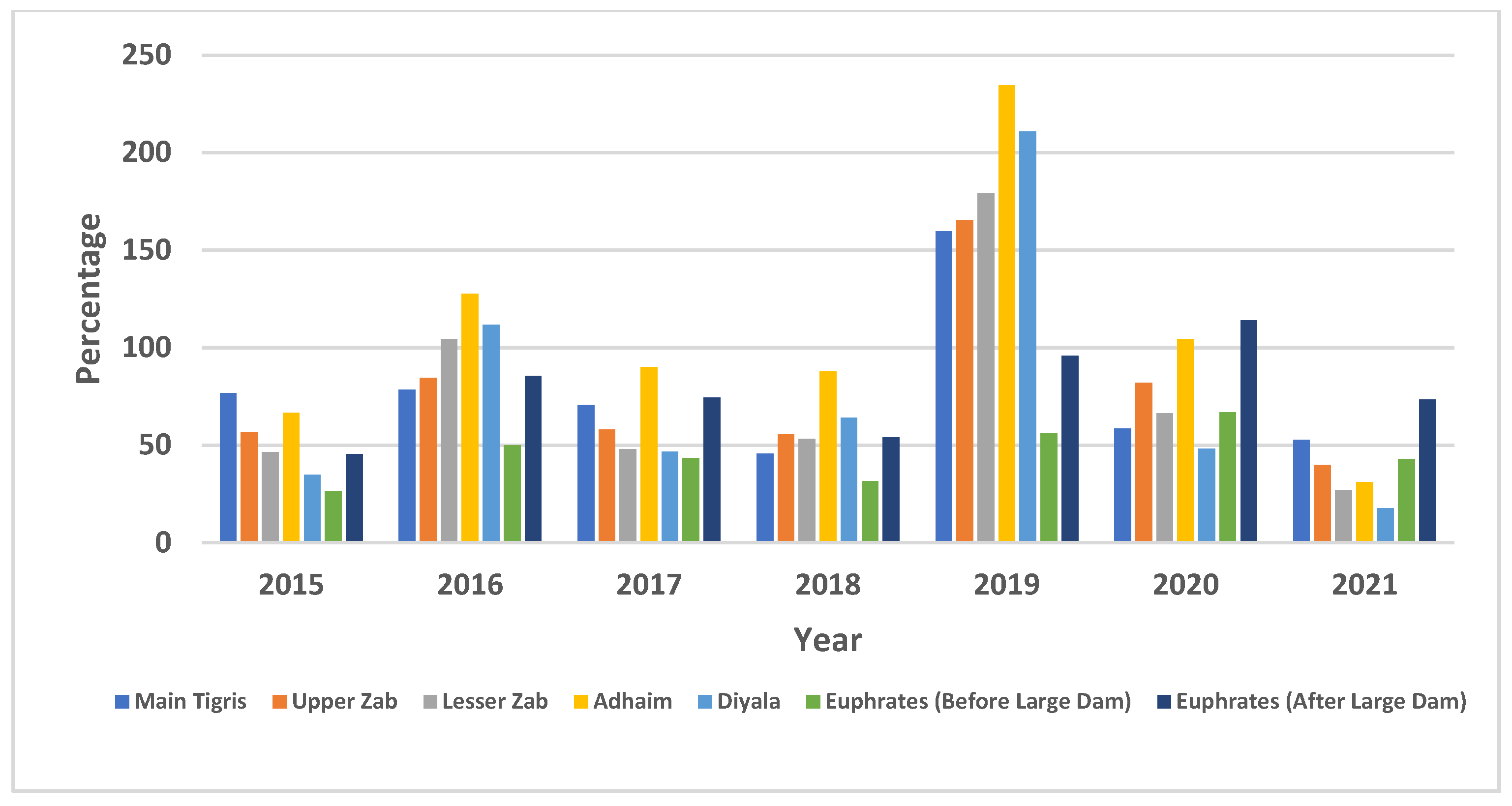
Furthermore, the current study highlights a significant reduction in inflow across the central and southern sections of the Tigris River inside Iraq, particularly in the south region at Kut, as shown in (Figure S1F). The assessment uses annual and seasonal flow data from mainstream flow gauge records across Iraq. The primary analysis draws on datasets and supporting information compiled from previous studies and published reports [26]. The flow records from the post-impact period (2015–2021) were compared to historical averages representing the natural flow regime to quantify the extent of water reduction. The comparison covers the Tigris River and its western tributaries, including the Upper and Lower Zab, Adhaim, and Diyala Rivers, as well as the main course of the Euphrates River. As presented in Figure 3, the graphs showing the percentage of annual flow relative to the long-term mean demonstrate substantial interannual variability in streamflow patterns. Notably, the Euphrates River exhibits a significant decline in mean annual flow of approximately 50% following the construction of large upstream dams and a subsequent shift in the flow regime. This reduction highlights the marked contrast in the percentage of annual flow during the period 2015–2021 when compared with the historical natural regime and the altered (impacted) flow regime across the two periods.
Moreover, the Standardized Drought Index (SDI) values were categorized into five drought classes, ranging from non-drought (SDI ≥ 0) to extreme drought (SDI < −2.0), thereby offering valuable insights into climate-driven and anthropogenic impacts on streamflow variability.
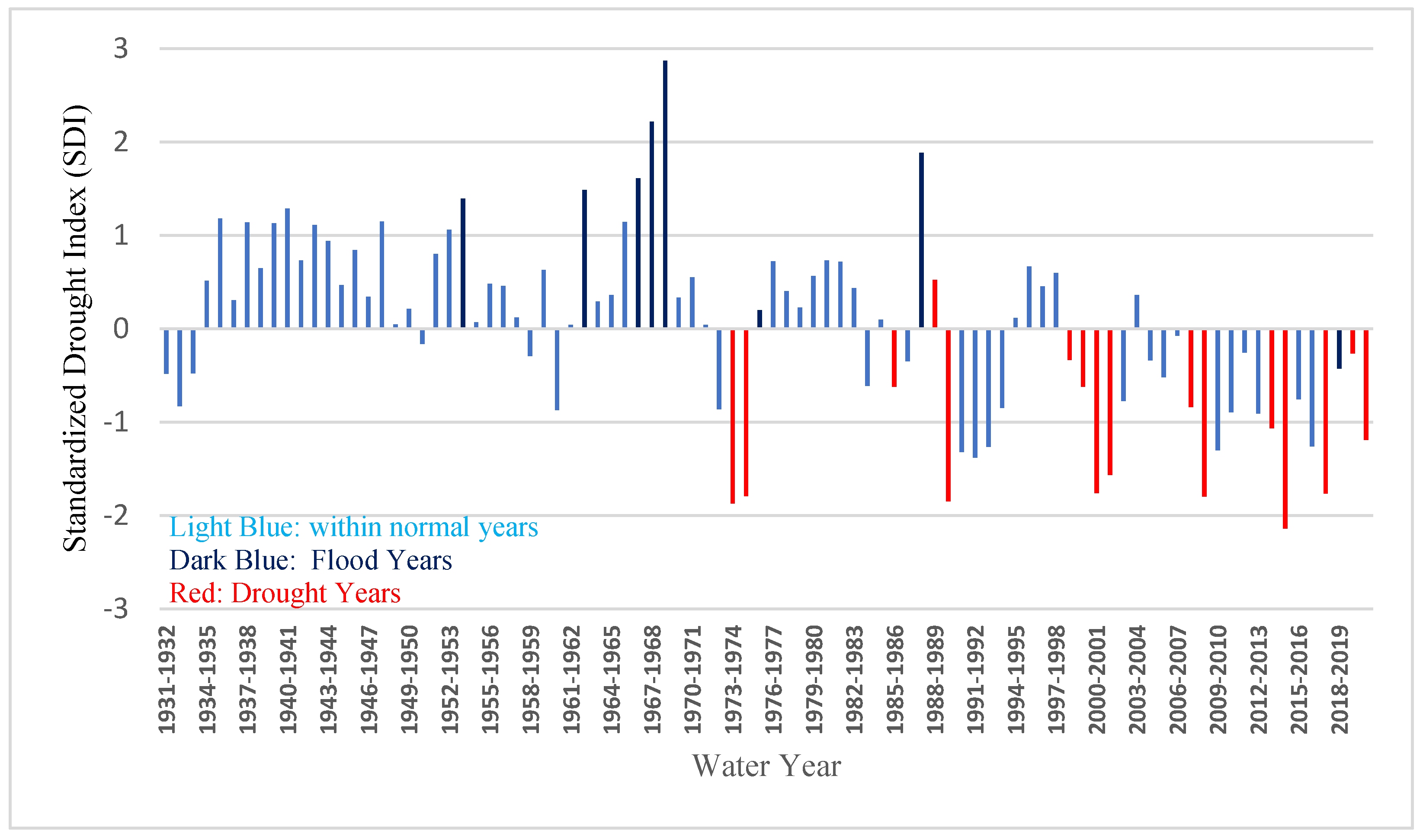
The SDI analysis for the Upper Tigris at Mosul also highlights these variations. Figure 4 indicates successive drought years between 2000 and 2021, except for the flood year 2019. Natural factors and human activities influenced these results, such as prolonged successive drought periods and upstream water control and withdrawals through a series of dams constructed by riparian countries.
The analysis of streamflow records for the Euphrates River inside Iraq, specifically at Husaybah City in the Al-Qa’im District of Al-Anbar Province, shows a significant reduction over time [21,27]. The recorded streamflow, which started in 1933, had an annual volume of about 30.00 BCM until 1972, but this decreased to approximately 23.5 BCM by 1990 and further declined to around 15.00 BCM by 2021.
Over the past two decades, the Euphrates River within Iraq has experienced notable reductions in streamflow, mainly due to upstream water regulation, cascade dam construction, and extensive withdrawals by riparian countries. These impacts are particularly evident during the third-period scenario (2000–2022), as detailed in the Supplementary Materials (Figure S1G). An analysis of the streamflow records in the Euphrates River at main key gauging stations, historically at Hit (1932–1974), Husaybah, and Haditha (1975-2022), reveals a consistent decline in both annual and mean monthly flows. Furthermore, successive drought years between 2000 and 2022, as shown in (Figure 5), which is based on the Standardized Drought Index (SDI), derived from a regenerated and combined sequence of the historical streamflow records from gauge stations along the Euphrates River within Iraq.
The analysis of the main Tigris and Euphrates inflows inside Iraq over the historical period 1933–2022 reveals significant changes. The total Tigris River flow showed a moderate reduction up to 1999, followed by a noticeable decline of about 31% over the last two decades (2000–2022) compared to its long-term annual inflows. On the other hand, the Euphrates River experienced a reduction of approximately 26.5% in 1999 and a substantial decline of 49.5% in 2021 relative to its long-term annual inflows.

5. Estimation of the General Water Consumption in Iraq

The current study highlights Iraq’s main stakeholders and water consumers, including the quantities of water allocated for various sectors (agricultural, domestic, industrial, and environmental) under various internal and external water stress conditions.
Based on the available studies and references, [21,26,28,29] suggest that the highest water demands or supplies come from the agricultural sector, accounting for about 60–80% depending on the hydrological water year conditions, while the domestic and industrial sectors represent approximately 9–12%, and environmental and water quality needs account for around 8–12% of the total available water resources. Additionally, total evaporation from water bodies and other losses are also considered.
Water supplies for each sector vary according to the hydrological conditions of the water year and the anticipated available strategies, such as live storage in main reservoirs and dams, weather and climate forecasting, and snow cover on the mountains of the upstream catchment area. These factors provide valuable insights into potential water resource inflows compared to assessments based on previous water years. However, Iraqi water resource management strategies prioritize ensuring the water supply for the drinking, domestic, and industrial sectors, as they directly link to human populations, inland fisheries, and animal husbandry.
Additionally, there is a focus on ensuring minimum water levels for municipalities and industrial intakes while maintaining the needs of environmental river ecosystems and improving water quality in rivers and wetlands.
Furthermore, water requirements for restoring marshlands in southern Iraq and freshwater needs along the Shatt al-Arab are essential to prevent saltwater intrusion. Total evaporation losses from water bodies are also a critical consideration. Based on these priorities and water conditions, the needs of other sectors, especially agriculture, are then assessed. Evaluations include determining agricultural demand for supplementary and irrigation water from the surface and available groundwater resources for the winter and summer seasons to plan and distribute proposed agricultural areas across the country.
The agricultural sector’s primary focus is on orchards, perennial trees, fields, vegetables, and fruits. Subsequently, the planned irrigation areas are determined for strategic crops, primarily wheat and barley, alongside rice in limited areas in the south due to high water requirements amid water scarcity. As an example, water use categories in Iraq for the year 2015 included the following: approximately 64% for the agricultural sector, 8% for municipalities and the industrial sector, 8% for wetland restoration, 5% for the Shatt al-Arab, and 1% for inland fisheries and animal husbandry. Additionally, evaporation losses accounted for about 13%, estimated at approximately 9.65 billion cubic meters [21].
The current study highlights the growing water demands in Iraq, driven by population growth, agricultural expansion, and rising water requirements across multiple sectors, while available water resources continue to decline. The long-term analysis, supported by various national and international studies and reports in addition to water strategy studies, reveals a significant future water deficit in the Tigris and Euphrates river basins. Iraq is projected to face an expanding gap between its available water resources and increasing demand due to upstream human activities and the impacts of climate change. Suppose current irrigation practices and sectoral water consumption remain unchanged. In that case, this gap between available water and various stakeholders’ water demands would grow from 5 to 11 billion cubic meters (BCM) between 2025 and 2035 [4,15,21,28,29,43,44].
Iraq is experiencing worsening water scarcity, threatening stability, water quality, and environmental sustainability. This further intensifies the country’s long-term water challenges and emphasizes the urgent requirements for sustainable water management solutions. Upstream water reduction and rising domestic demands drive the increasing water deficit within Iraq.
All these impacts necessitate a proactive plan to reduce the highest water demands, particularly in the agricultural sector. Without completing essential rehabilitation and reclamation efforts to enhance irrigation efficiency and decrease overall water consumption, Iraq will face significant challenges in meeting its water requirements. Additionally, a shift from traditional irrigation methods and water resource management to intelligent and integrated water resource systems is crucial. Management includes implementing AI and SCADAs for monitoring in real time and controlling key water releases and developing comprehensive decision support systems (DSSs) for managing surface and groundwater resources across Iraq.

6. History and Definition of Decision Support Systems (DSSs)

6.1. Overview of Decision Support Systems (DSSs)

Decision support systems (DSS) are computer-based tools that support complex decision-making and problem-solving processes [45] (p. 183), [46] (p. 740), [47] (p. 799), [48] (p. 112). Its foundational influence was Vannevar Bush’s 1945 concept of the “memex,” a device to enhance memory through rapid information retrieval [49]. Key developments followed, including Dantzig’s linear programming (1952), Engelbart’s oNLine System (NLS) in the 1960s, and Forrester’s SAGE and DYNAMO systems at MIT [49]. By the mid-1970s, DSSs became an established research field, later evolving into systems such as Executive Information Systems (EISs), Group DSSs (GDSSs), and Organizational DSSs (ODSSs). In the 1990s, innovations like data warehousing, OLAP, and web-based tools significantly broadened DSSs’ capabilities. Nevertheless, a DSS integrates multiple disciplines, including AI, databases, simulation, and telecommunications [50]. In water resources, the concept has evolved independently or as an interface for existing models [51]. While robust, DSSs should support but not replace expert decision-makers [52] (pp. 1–2) They may help structure information, simulate options, and guide actions. According to Mora et al. [53] (pp. xv–xvi), their main advantages include high-level support, flexibility, “what-if” analysis, and adaptability to specific decision-making requirements.

6.2. Decision Support Systems in Water Resource Management

Water is an essential resource for the sustainability and growth of all societies. Its availability is crucial to the very existence of these societies and the environment in which they prosper [54]. However, this availability depends on two key factors: first, access to water for beneficial uses, and second, obtaining the necessary quantity at the required quality precisely when it is needed [55]. These factors are influenced by how water is delivered, whether as rain or snow, as well as by its intensity, duration, and frequency.
In many cases, the full benefits of water resources also depend on natural conditions. These include the physical setting of the region, such as climate, weather patterns, topography, and geology [56]. Additionally, engineering structures, existing ecosystems [57], environmental constraints, and legal and regulatory frameworks play crucial roles. Furthermore, institutional policies significantly influence water resource management. In turn, cultural values and community preferences are also key factors shaping water use and management decisions.
Sustainable water management requires integrated policies informed by a clear understanding of water systems and the consequences of management decisions [58] (p. 13). However, human activities have often disrupted natural systems, leading to erosion, poor water quality, and reduced reservoir capacity [59] (p. 2). Moreover, in the case of Iraq, reliance on outdated irrigation techniques and excessive consumption further contribute to water scarcity, while the pollution of water bodies also remains a critical issue [60] (p. 10). Therefore, effective water governance must balance technical solutions with ecological awareness and responsible resource use.
Water pollution has worsened due to untreated industrial waste and urban wastewater. Furthermore, the return flows from agricultural lands have caused the chemical and biological contamination of these rivers and streams [61]. Poor water management and climate change intensify global water scarcity [62]. Extreme weather events like floods and droughts are becoming more frequent and severe [63]. Upstream developments and water projects, such as dams and irrigation expansions by upstream riparian countries, impact the shared basins of the Tigris and Euphrates Rivers. These activities and climate change lead to severe water scarcity and altered flow regimes in downstream countries like Iraq [64] (pp. 6–7) [65]. Freshwater scarcity, driven by population and industrial growth, demands science-based management [66].

6.3. Examples of DSS Use for Integrated Water Management

Integrated watershed planning and decision support systems (DSSs) are key to sustainable water use. In a practical application of a decision support system (DSS), the AQUATOOL-SIMGES model was used in Ecuador’s Tabacay River basin to support water management planning until 2030 under four scenarios. These included population growth, reservoir use, and changing agricultural demand [67]. Nevertheless, water management has evolved from basic experience-based methods to advanced, technology-supported approaches due to growing complexity and climate challenges [68] (pp. vii–viii), [69] (p. 2), [70]. Modern decision support systems (DSSs) now aid integrated water management by offering scenario-based planning [71] (pp. 2–3). These tools are widely used in regions such as Ireland, the Mediterranean, and US river basins for efficient resource management and climate adaptation [72] (pp. 2–3), [73] (pp. 2–5), [74] (pp. 2–4).
The current study highlights two key case studies that applied decision support systems (DSSs) for integrated water resource management: the Middle Rio Grande and Colorado’s Decision Support System (CDSS). These provide practical examples for implementation in Iraq’s Tigris and Euphrates river basins.

6.3.1. Use of DSS in Middle Rio Grande Integrated Water Management

The Middle Rio Grande River Basin uses an advanced water management system for semi-arid regions with under 10 inches of annual rainfall and competing demands from agriculture, urban use, industry, and the environment [75,76]. It relies on the Rio Grande, its tributaries, groundwater, and trans-mountain diversions from the Colorado River. River diversions, return flows, and seasonal reservoir releases support irrigation, with water delivery delays of up to seven days. The Middle Rio Grande Basin uses a decision support system (DSS) linked with a Supervisory Control and Data Acquisition System (SCADA) for automated and efficient water delivery [77] (pp. 187–204). Moreover, MRGCD oversees 1200 miles of canals and 200 miles of levees, and irrigates 70,000 acres. The DSS includes water demand, the supply network, and scheduling modules, all connected through a user-friendly interface to support real-time decision-making [78] (pp. 71–100).
The DSS operates in two modes: planning and operation. In planning mode, users input cropping patterns and related data to estimate irrigation demand and schedule canal diversions. The system uses available canal flows to generate optimal delivery schedules in operation mode using the open-source GNU Linear Programming Kit (GLPK) [77]. Integrated with SCADA, it automates water distribution through sensors, control structures, telemetry, and specialized software.
Figure 6A shows an example of a crested weir gauging station for water measurement with radio telemetry, and Figure 6B shows an automated Langemann gate [77] (pp. 194, 203).
Langemann-type gates regulate water levels or flow rates and are solar-powered for automated control and telemetry. They serve multiple functions, such as checks, turnouts, and spillways, including sensors for digital water level monitoring. The V-system supervisory Hydro-data Acquisition and Handling System (SHAHS) software streamlined automated water management in the MRGCD, improving efficiency, reducing diversions, and minimizing conflicts, aided by public outreach on scheduled water delivery [77] (pp. 191–194), [79] (pp. 2–5). The system improved irrigation efficiency, delivery reliability, and planning for future water demands. A public campaign that educated users on scheduled water delivery and encouraged communication between water managers and users helped to make it a success.

6.3.2. Use of DSS for Water Management in Colorado (USA)

Colorado’s Decision Support System (CDSS), developed by the Colorado Water Conservation Board (CWCB) and the Colorado Division of Water Resources (DWR) for Colorado’s five major river basins, supports informed water management within the Colorado River Basin [80,81]. The CDSS provides integrated tools for data management, modeling, and decision-making in planning, compact compliance, and water rights. Key components include HydroBase (data repository), spatial data tools (GIS), StateMod (surface water allocation model), and StateCU (agricultural water use estimator).
These systems provide access to quality-controlled data, HydroBase-centered databases, and GIS tools for evaluating water management strategies [82,83]. The frameworks support an integrated, upgradable state system, reflect current policies and regulations, and encourage information sharing among agencies and water users.

7. Integrated Comprehensive Water Management Strategy (ICWMS) and Introduction of Decision Support Systems (DSSs) in Iraq

7.1. Steps for Implementing the DSS Plan

In response to the growing water scarcity in Iraq, which threatens its stability and existence, the country must urgently develop and implement a new integrated water resource management strategy that modernizes existing infrastructure, optimizes water use for maximum efficiency, and includes clear objectives, a defined implementation timeline, adaptable scenarios, a staged execution plan with periodic reviews, and the introduction of a decision support system (DSS) based on the main steps of the DSS, which are shown in Table 1 below.
The primary goal of this strategy is to maximize water utilization efficiency in Iraq, drawing on the progress made in advanced countries while meeting all competing demands. Assessing global water usage trends helps achieve this goal. Agriculture consumes the largest share of freshwater worldwide, accounting for approximately 70% of all water withdrawals, though this varies regionally. For instance, in the United States, agriculture represents over 80% of their total water consumption (USDA, 2010) [31].
The productivity of irrigated land is approximately three times greater than rain-fed land (FAO, 2010) [84]. Thus, irrigation is a critical component of sustainable agricultural systems. As global food production continues to grow, so does the demand for water in agriculture, placing increasing pressure on irrigation systems and freshwater resources (UN, 2006) [85]. Agriculture also contributes to surface and groundwater degradation through runoff; thus, agriculture must efficiently use water for irrigation and the protection of water sources, utilizing techniques such as organic farming, micro-irrigation, and rainwater harvesting. Since the industry is responsible for 22% of global water use, it must adopt efficient methods to limit water consumption through tailored appliances and processes [86].
A potential target for water efficiency in Iraq could be 85% by 2050, depending on the outcomes of the water management strategy. However, it is important to note that Iraq is falling short of the FAO’s 2030 targets set in 2018 [87]. The authorities must dedicate significant efforts to catch up and achieve the final goals by 2050. Given the rapid global advancements in the application of AI across various sectors, it is important to leave room for improvements in the decision support system (DSS), with goals being adjusted accordingly during the upgrading process.
Upon implementation, the Integrated Comprehensive Water Management Strategy (ICWMS) should prioritize the optimization of water availability through two key measures: enhancing the Ministry of Water Resources’ capacity with advanced technical tools for negotiation, promoting the utilization of unconventional water resources such as desalination and rainwater harvesting [88]; and ensuring the enforcement of stringent water quality standards while fostering cooperation with riparian nations to safeguard the quality of water inflows into Iraq.

7.2. Implementing a DSS in the Integrated Comprehensive Water Management Strategy (ICWMS) for Iraq

The timeline for this initiative extends to 2050, with the work divided into successive stages aligned with the development and implementation of the Comprehensive Water Management Strategy (CWMS). In the first stage (2025–2030), decision support systems (DSSs) and SCADAs will be installed at the National Center for Water Resource Management (NCWRM) for automated operation and decision-making, while fieldwork will focus on restoring river courses and maintaining infrastructure, alongside the development of the ICWMS, including necessary data modules and software.
The second stage (2030–2035) will fully automate distribution and control structures in major irrigation networks, assuming modern standards achieve water-saving methods and efficient on-farm irrigation within the distribution networks. The DSS will accommodate various scenarios, including changes in Tigris and Euphrates inflows, climate change impacts, and population growth, ensuring optimal water management decisions are made based on real-time conditions.

7.3. Developing a General Framework for Decision Support Systems (DSSs) in Iraq’s Integrated Comprehensive Water Management Strategy (ICWMS)

The current study proposes a flexible framework for the sustainable planning and management of water resources in Iraq’s Tigris and Euphrates Rivers, addressing various internal and external multi-impact hazards. The framework aims to achieve a water balance based on sustainable water resource management principles and hydro-meteorological indicators. It adopts short- and long-term strategic perspectives, considering hydro-geopolitical conditions to mitigate the gap between water availability and multi-stakeholder requirements. By integrating these elements, the proposed framework strengthens resilience and promotes the efficient and sustainable utilization of existing water resources.

7.4. Water Budget

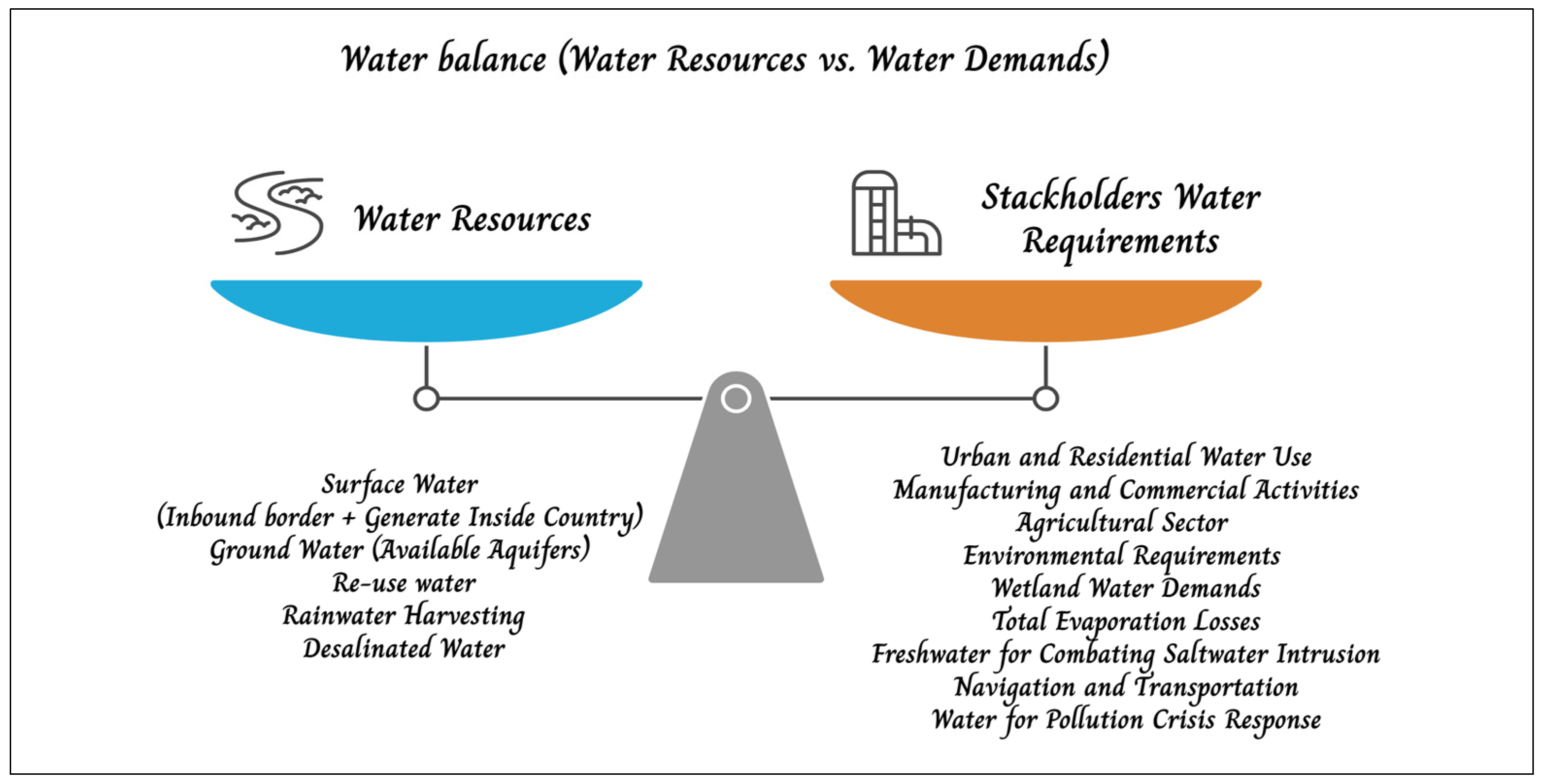
The current study highlights the central concept of water balancing between water resources and various stakeholders’ demands, which is shown in Figure 7 below.
The primary water resources include surface and groundwater, generated inside and outside the country for each river catchment basin. On the other hand, other non-conventional water resources, such as treated wastewater from drainage systems, can be reused for various purposes, including developing green belts around cities. Rainwater harvesting, particularly in desert areas, can contribute to groundwater recharge and support small water projects for domestic use. Additionally, desalinated seawater, especially in regions far from natural water sources, can contribute to an essential drinking water supply and other domestic requirements. In contrast, this study classified the multiple stakeholders’ water requirements and the priority of each sector.
Domestic and municipal water use receives the highest priority [89], as it directly relates to people’s needs for drinking and household purposes, alongside municipal services and manufacturing. The second priority is the environmental water requirements of rivers, which support ecosystems, biodiversity, and marshland or swamp areas. The agricultural sector represents the largest water-consuming sector within and outside the fields. Evaporation losses from water bodies such as rivers, lakes, and reservoirs cause substantial water loss, especially during Iraq’s hot, dry summers, depleting around 10 billion cubic meters (BCM) annually [4]. Evaporation intensifies water scarcity, further aggravated by reduced inflows, climate change, and rising demand. Essential mitigation strategies for sustainable water management involve restricting exposed water surfaces and optimizing reservoir operations, and these are essential for sustainable water management.
Other essential water allocations include maintaining the minimum water levels for navigation, ensuring environmental protection, and preventing saltwater intrusion, such as in the Shatt Al-Arab [90], in addition to addressing critical situations like diluting water pollution in case of oil spills or chemical leaks.

7.5. The Unified Platform with a Multi-Dimensional System for Sustainable Water Resource Management, Tigris and Euphrates River Systems, Iraq

This study suggests a unified platform system for sustainable water resource management, as shown in Figure 8 below. This system integrates available water resources and stakeholders’ water demands through hydrogeological simulation models to assess surface and groundwater availability. This system incorporates transboundary inflows and nationally generated water resources through hydrological and geological simulation models [91]. Geographic Information Systems (GISs) and remote sensing techniques enhance these models by enabling the assimilation of meteorological data, snow cover analysis, land use/land cover classification, and satellite-derived hydrological parameters. Hydrological models simulate water availability under various conditions, including droughts, standard years, and floods, while also forecasting the impacts of climate change on temperature, evapotranspiration, and precipitation under different projections of carbon emission scenarios. Additionally, the models account for anthropogenic impacts by assessing the potential changes in river flow regimes due to water withdrawals by upstream riparian countries, water storage through dams, regulation, and the expansion of irrigation.
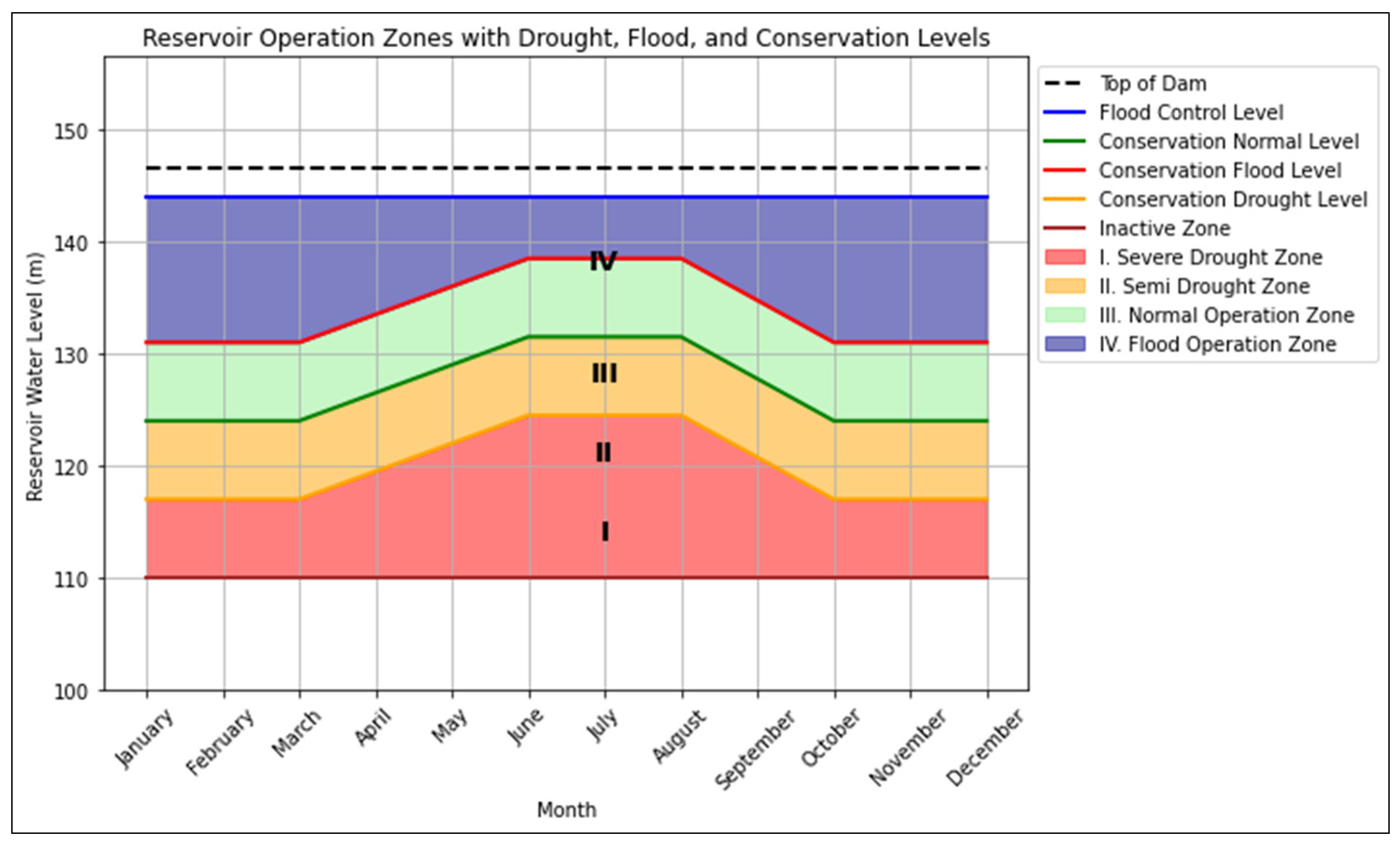
The second phase of the framework focuses on optimizing reservoir operations by employing multivariate optimization techniques and reservoir simulation models, such as HEC-ResSim, to improve rule curve operations. This approach replaces a single rule curve with multiple monthly rule curves, an advantage during extreme hydrological conditions such as droughts, floods, and average water years. The framework minimizes water deficits and penalties while meeting downstream demands by dynamically adjusting reservoir releases based on real-time data and interconnected reservoir storage. HEC-ResSim, a widely used reservoir simulation model, integrates multivariate optimization to evaluate and optimize operational strategies under various scenarios. This model ensures efficient water allocation during droughts by prioritizing critical demands and conserving storage. It maximizes flood control by adjusting releases to prevent downstream damage in flood scenarios. The model balances storage and releases for average water years to maintain optimal reservoir levels. Multiple rule curves enhance flexibility and adaptability, allowing for more precise and context-specific reservoir management, as Figure 9 below suggests. This integrated approach, combining advanced and multivariate optimization techniques with simulation modeling, significantly improves the resilience and efficiency of reservoir operations across diverse hydrological conditions [92,93,94].
These are further integrated with hydrodynamic flood routing models and standardized environmental and water quality indicators, enabling the simulation of various water resource management strategies under different hydrological scenarios [95]. These integrated approaches provide a robust decision support framework for sustainable short- and long-term water resource planning, helping to ensure resilience against climate variability and anthropogenic pressures on marshland and environmental river ecology [96].

7.6. General Framework of Decision Support System (DSS) for Tigris and Euphrates River Basins, Iraq

The proposed framework for the decision support system (DSS) for the Tigris and Euphrates river basins will address water management challenges holistically.
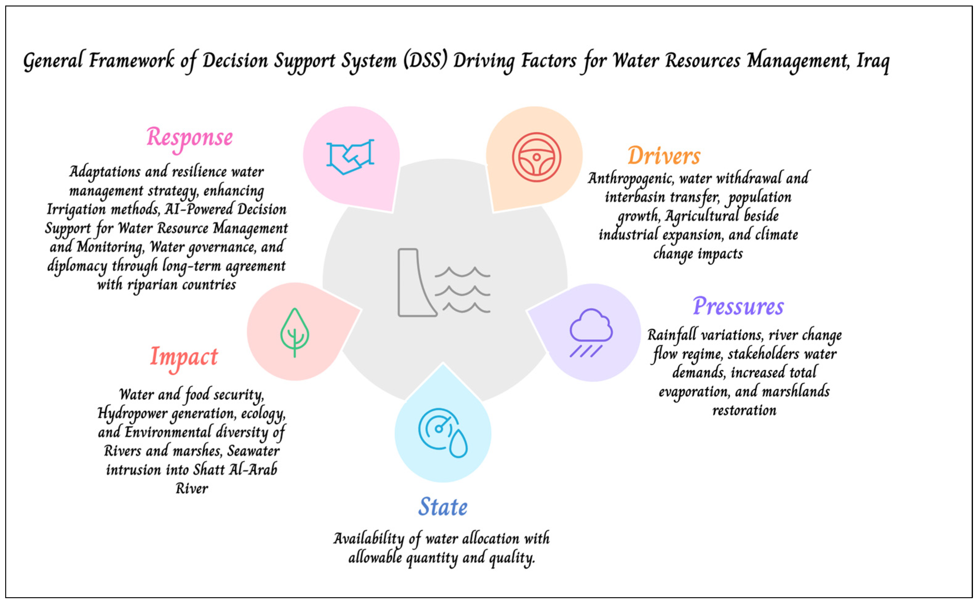
Inspired by the MULINO-DSS framework [97,98], it is structured around five interconnected factors: Driving Forces (D), Pressures (P), State (S), Impacts (I), and Responses (R) [99,100,101]. These factors provide a systematic way to analyze and manage the complex interactions within the river basins. Figure 10 and Table 2 illustrate the main factors of the DSS associated with water resource management inside Iraq.
This current study presents a comprehensive framework for analyzing and addressing water resource challenges in the transboundary Tigris and Euphrates river basins, focusing on Iraq as a downstream country. The core of this framework is a multi-dimensional system designed for sustainable water resource management. It integrates hydro-meteorological data, advanced simulation models, and a multi-dimensional analysis to optimize water management strategies. A decision support system (DSS) supports the framework, which systematically identifies key variables, influential factors, and strategic interventions essential for navigating the complexities of transboundary water governance. By leveraging data analytics, simulation modeling, and strategic optimization, the proposed DSS framework provides a scientifically grounded and integrated approach to managing the shared water resources of the Tigris and Euphrates. This approach addresses the region’s critical water challenges and ensures the sustainable allocation of resources. Furthermore, it enhances resilience, promotes socio-economic and environmental stability, and fosters cooperation among riparian states, ultimately contributing to more effective and equitable water governance.

8. Toward a Transboundary DSS for Iraq: A Phased Implementation Strategy

Iraq’s water resource sector is increasingly vulnerable to anthropogenic pressures, including upstream flow regulation, climate change impacts, institutional constraints, and rising agricultural, municipal, and environmental demands. These escalating challenges underscore the urgent need for a nationally integrated and regionally compatible decision support system (DSS) that supports real-time operational decision-making, long-term water planning, and informed transboundary cooperation. This study proposes a phased strategy for developing such a system, aimed at establishing a national platform for water governance that also serves as a foundation for regional negotiation and technical collaboration.
Iraq is dependent on inflows from upstream riparian countries; therefore, the effectiveness of the proposed DSS depends on its integration into a broader framework of bilateral, trilateral, and multilateral water agreements. Such cooperative arrangements are essential for facilitating hydrological data exchange, harmonizing reservoir operations, and establishing joint forecasting and risk assessment mechanisms. These measures would help shift Iraq’s current fragmented management model toward a more coordinated and equitable basin-wide governance approach.
Numerous international case studies offer transferable models for such a transformation. The Mekong DSS enables structured consultation between states through the Procedures for Notification, Prior Consultation, and Agreement (PNPCA), established under the 1995 Mekong Agreement [102]. The Danube DSS, implemented through the International Commission for the Protection of the Danube River (ICPDR), supports real-time flood forecasting, water quality monitoring, and regulatory compliance across 19 countries [103]. In the Nile Basin, the DSS developed by the Nile Basin Initiative provides scenario-based planning tools to evaluate dam impacts and climate adaptation strategies, thereby supporting ongoing negotiations among Egypt, Sudan, and Ethiopia [104]. Similarly, the Indus Waters Treaty (Al-Sindh) between India and Pakistan institutionalizes technical data exchange and the bilateral monitoring of shared rivers [105].
In line with these models, this study introduces a nationally tailored Multi-Hazard Risk Matrix, which is shown in Supplementary Materials (Table S1), structured using the DPSIR (Driving Forces–Pressures–State–Impact–Response) framework and fully integrated into the proposed DSS architecture. This matrix enables the simulation and prioritization of complex hydrological and institutional risks, including upstream flow reductions, extreme droughts, institutional fragmentation, flood exposure, and the degradation of ecological services. Previous studies in the Euphrates–Tigris basin have highlighted the geopolitical and institutional challenges facing transboundary cooperation and have emphasized the need to enhance stakeholder engagement and reduce conflict through regional agreements and improved coordination mechanisms [106].
The phased implementation of the DSS begins with the establishment of regional data-sharing agreements with upstream countries to support joint hydrological modeling and early warning systems. A centralized, GIS-based platform should be developed to integrate historical records, real-time hydrological and climatic observations, remote sensing outputs, and predictive modeling capabilities. The Multi-Hazard Risk Matrix will function as a core decision support tool within the DSS, enabling planners to simulate risk scenarios and prioritize mitigation strategies. Concurrently, real-time operational models should be calibrated for Iraq’s major reservoirs to enhance multi-purpose storage management and optimize seasonal releases under variable demand and climate stress.
In order to ensure system responsiveness and accuracy, a SCADA with AI system-enabled monitoring infrastructure should be deployed at key hydraulic installations, providing automated, high-frequency data on reservoir levels, canal diversions, and gate operations. These datasets will feed directly into the DSS, supporting real-time analytics and long-term simulations. Technical interoperability should be maintained by adopting open-source, standardized modeling platforms such as HEC-HMS, WEAP, SWAT, and Python-based tools, facilitating future integration with regional DSS platforms.
The DSS should be spatially expanded to cover key transboundary tributaries such as the Tigris, Euphrates, Karkha, and Karun Rivers and their associated dam and irrigation systems. This geographic extension will improve the spatial resolution of intra-basin assessments and support equitable allocation across administrative and ecological units.
Nevertheless, the outputs generated by the DSS, including flow forecasts, drought impact models, and dam operation simulations, should be leveraged to strengthen Iraq’s technical and legal positions in regional water negotiations. By aligning these outputs with the principles of the United Nations Watercourse Convention [107,108], Iraq can promote transparency, equity, and sustainability in the governance of its shared transboundary water resources.

9. Complementary Actions Required for the Success of ICWMS and DSS Introduction

An ambitious strategy like the one outlined requires complementary actions from the Government of Iraq to tackle the growing water crisis. These actions include the following:
(a)
Mobilizing the country’s financial and human resources to initiate and implement the strategy while creating legal frameworks that enable the National Center for Water Resource Management (NCWRM) to make decisions free from external pressures and corruption.
(b)
Establishing a governing authority, the Iraqi Federal Water and Environment Council (IFWEC), to coordinate efforts across ministries, resolve inter-agency conflicts, and oversee the effective implementation of national policies related to water resource management, environmental protection, and the mitigation of climate change impacts.
(c)
Conducting a comprehensive review of existing water laws by updating outdated regulations, introducing penalties for water misuse, and activating federal water law institutions to regulate water distribution between regions and ensure fair water appropriation.
(d)
Financial and Investment Strategies: Encouraging investment through annual governorate plans, private sector engagement, and partnerships with upstream countries. Encouragement includes fostering Regional and International Development Investments (RIDIs) in the agriculture, energy, and municipal sectors and securing international support through soft loans for farmers and sustainable development projects.
(e)
Infrastructure Rehabilitation and Efficiency Improvement: Rehabilitating irrigation systems, enhancing water distribution networks, promoting piped conveyance to reduce losses, and increasing irrigation efficiency to conserve water.
(f)
Technological Integration and Monitoring: Utilizing AI, GIS, remote sensing, satellite imagery, SCADA, and DSSs to support micro-irrigation, monitor water use, detect encroachments, forecast trends, and optimize distribution. These innovative technologies support data-driven decision-making inspired by successful models like the Colorado River Basin and New Mexico.
(g)
Water Diplomacy and Transboundary Cooperation: Establishment of the Iraqi Supreme Water Council (ISWC) to lead negotiations with upstream countries and ensure rational water use and a fair, equitable share of water among riparian countries through long-term agreements. This approach promotes shared benefits, addresses water scarcity impacts, and encourages regional cooperation. Academic institutions support it through education, research, and the development of integrated water–energy–environmental management and strategies to mitigate and adapt to climate change impacts.
(h)
Incorporate Water–Food–Energy–Environment (WFEE) nexus analysis into the DSS and ICWMS frameworks to enable integrated, cross-sectoral water planning that balances competing demands for irrigation, hydropower, ecosystem sustainability, and food security under conditions of climate variability and transboundary water constraints.
(i)
Community Engagement and Awareness: Raising public awareness of water conservation and climate change adaptation through education campaigns in schools, universities, and media platforms.

10. Conclusions

The water resource sector in Iraq is currently facing a critical situation marked by severe water scarcity across all sectors due to compounded impacts from anthropogenic activities and climate change. Contributing factors include reduced river flows from the Euphrates, Tigris, and their tributaries, with a 31% decrease in the Tigris and a 49.5% decline in the Euphrates by 2021. The lack of fair water-sharing agreements with neighboring countries (Turkey, Iran, and Syria), inefficient water management policies, and the adverse effects of climate change exacerbate the situation. Prolonged droughts cause farmers to abandon agricultural lands, desertification, urban migration, rising unemployment, poverty, and social instability, resulting in an uncertain future for food security. This study also projects a future water deficit of 7–20% between 2020 and 2035, which may worsen due to the increasing frequency of floods and successive drought years driven by climate change. Iraq, a country with a rapidly growing population, faces additional pressure on its water resources [109,110]. There is an urgent need for new water management policies and strategies. This study proposes an Integrated Comprehensive Water Management Strategy (ICWMS), incorporating decision support systems (DSSs) and automated controls for water distribution. The successful implementation of this strategy requires continuous updates, cooperation among government departments, a new legislative framework, and active participation from all stakeholders and the public to tackle these challenges and secure a sustainable future for Iraq. Fortunately, the Ministry of Water Resources of Iraq has recently become aware of the need for complete revision and comprehensive action to rectify the situation and, therefore, has embarked on developing a new strategy that considers all problems and obstacles. In this context, a workshop was held in Baghdad at the Ministry of Water Resources in October 2024 to discuss the required modifications for updating the existing water strategy. However, realizing such a water strategy requires significant effort, substantial investments, and a commitment to diligence. Moreover, it requires support from specialized international organizations and enlisting world-class consulting expertise.

Supplementary Materials

The following supporting information can be downloaded at https://www.mdpi.com/article/10.3390/w17121748/s1, Supplementary Materials (Figure S1): The Long-term monthly discharge for the key stations at (A) Mosul, (B) Upper Zab, (C) Lower Zab, (D) Diyala, (E) Baghdad, (F) Kut in the Tigris and tributary rivers, and (G) At Haditha-Hit on the Euphrates River, Iraq, at various historical periods (1933–2022). Supplementary Materials (Table S1): The Multi-Hazard Matrix with DSS-DPSIR integration—Iraq.

Author Contributions

Conceptualization, all authors; methodology, H.A.-H. and N.A.; software, H.A.-H.; validation, all authors; formal analysis, H.A.-H.; investigation, H.A.-H.; data curation, H.A.-H.; writing—original draft preparation, all authors; writing—review and editing, N.A. and N.A.-A.; visualization, all authors; supervision, K.B. and R.R. All authors have read and agreed to the published version of the manuscript.

Funding

This research was funded by [Széchenyi István University].

Data Availability Statement

This study integrates and analyzes various datasets collected and compiled from multiple sources, studies, and research. Most datasets are publicly available and have been cited in the manuscript, while others were compiled, and partially generated during the research. Additional datasets used in the analysis are available from the authors upon reasonable request.

Conflicts of Interest

The authors declare no conflicts of interest.

References

  1. Grigg, N.S. Two Decades of Integrated Flood Management: Status, Barriers, and Strategies. Climate 2024, 12, 67. [Google Scholar] [CrossRef]
  2. Alamanos, A. Sustainable Water Resources Management under Water-Scarce and Limited-Data Conditions. Cent. Asian J. Water Res. 2021, 7, 1–19. [Google Scholar] [CrossRef]
  3. Wen, S.; Feng, Z. Theoretical analysis and applications of artificial intelligence in hydrology and water resource management. Water Supply 2023, 23, 3–6. [Google Scholar] [CrossRef]
  4. Al-Ansari, N.; Ali, A.; Knutsson, S. Present Conditions and Future Challenges of Water Resources Problems in Iraq. J. Water Resour. Prot. 2014, 6, 1066–1098. [Google Scholar] [CrossRef]
  5. Algaze, G. Ancient Mesopotamia at the Dawn of Civilization: The Evolution of an Urban Landscape; University of Chicago Press: Chicago, IL, USA, 2008. [Google Scholar]
  6. Postgate, J.N. Early Mesopotamia: Society and Economy at the Dawn of History; Routledge: London, UK; New York, NY, USA, 1994. [Google Scholar]
  7. Tigris and Euphrates Rivers: Hydrology, Water Quality and Shortage, Water Projects and Geology. Spec. Issue J. Earth Sci. Geotech. Eng. 2019, 9. Available online: https://www.scienpress.com/journal_focus.asp?Sub_id=IV&main_id=59&volid=412 (accessed on 10 April 2024).
  8. Al Shami, A.H.M.; Al-Faraj, F.A.M.; Khoshnaw, H.A.; Barzangi, K.K. Stock-Taking Report for the Preparation of the World Bank’s Country Water Resources Assistance Strategy for the Republic of Iraq; FAO Investment Centre/World Bank: Rome, Italy, 2005; p. 29. [Google Scholar]
  9. Salman, S.A.; Shahid, S.; Sharafati, A.; Salem, G.S.A.; Ahmed, K.; Chung, E.-S. Projection of agricultural water stress for climate change scenarios: A regional case study of Iraq. Agriculture 2021, 11, 1288. [Google Scholar] [CrossRef]
  10. Saleh, D.K. Stream Gage Descriptions and Streamflow Statistics for Sites in the Tigris River and Euphrates River Basins, Iraq; US Geological Survey; US Department of the Interior: Reston, VA, USA, 2010; Volume 540.
  11. Alwan, I.A.; Karim, H.H.; Aziz, N.A. Agro-Climatic Zones (ACZ) Using Climate Satellite Data in Iraq Republic. IOP Conf. Ser. Mater. Sci. Eng. 2019, 518, 022034. [Google Scholar] [CrossRef]
  12. Kankal, M.; Nacar, S.; Uzlu, E. Status of Hydropower and Water Resources in the Southeastern Anatolia Project (GAP) of Turkey. Energy Rep. 2016, 2, 123–128. [Google Scholar] [CrossRef]
  13. Loucks, D.P.; van Beek, E. Water Resource Systems Planning and Management: An Introduction to Methods, Models, and Applications; Springer: Cham, Switzerland, 2017. [Google Scholar] [CrossRef]
  14. Faraj, D.M.; Abdulrahman, K.Z.; Al-Ansari, N.A. The impact of the Tropical Water Project on the operation of Darbandikhan dam. J. King Saud. Univ. Eng. Sci. 2024, 36, 385–390. [Google Scholar] [CrossRef]
  15. World Bank. Iraq—Country Water Resource Assistance Strategy: Addressing Major Threats to People’s Livelihoods; Report No. 36297-IQ; World Bank: Washington, DC, USA, 2006; pp. 1–90. [Google Scholar]
  16. Al-Ansari, N.; Adamo, N.; Hachem, A.H.; Sissakian, V.; Laue, J.; Abed, S.A. Causes of Water Resources Scarcity in Iraq and Possible Solutions. Engineering 2023, 15, 467–496. [Google Scholar] [CrossRef]
  17. Agriculture Reconstruction and Development Program for Iraq (ARDI). Strategy for Water and Land Resources in Iraq: Inception Report; United States Agency for International Development (USAID): Baghdad, Iraq, 2005.
  18. United Nations Development Programme (UNDP). Water Resources Decision Support System for the Ministry of Water Resources of Iraq: Draft Final Report; UNDP: Baghdad, Iraq, 2014. [Google Scholar]
  19. T-Zero. SWRLI—Strategy for Water and Land Resources in Iraq. Available online: https://t-zero.it/en/portfolio/swlri-strategy-for-water-and-land-resources-in-iraq/ (accessed on 10 April 2024).
  20. HydroNova. Strategy for Water and Land Resources in Iraq (SWRLI). Available online: https://hydronova.tech/project/swlri/ (accessed on 10 April 2024).
  21. Japan International Cooperation Agency (JICA). Data Collection Survey on Water Resource Management and Agriculture Irrigation in the Republic of Iraq; NTC International Co., Ltd.: Tokyo, Japan, 2016. [Google Scholar]
  22. Wikipedia. Ministry of Water Resources (Iraq). Available online: https://en.wikipedia.org/wiki/Ministry_of_Water_Resources_(Iraq) (accessed on 10 April 2024).
  23. Ministry of Water Resources. Iraq’s ‘Mission and Vision. Available online: https://mowr.gov.iq (accessed on 30 December 2024).
  24. National Centre for Water Resources Management, Iraq. Available online: https://wrm.mowr.gov.iq/ (accessed on 5 August 2023).
  25. United Nations Economic and Social Commission for Western Asia (UN-ESCWA); Bundesanstalt für Geowissenschaften und Rohstoffe (BGR). Inventory of Shared Water Resources in Western Asia; UN: Beirut, Lebanon, 2013. [Google Scholar]
  26. Iraq Ministry of Planning; Central Statistical Organization; Directorate of Agricultural Statistics. Water Resources Reports 2015–2020; Ministry of Planning: Baghdad, Iraq, 2020. Available online: https://www.cosit.gov.iq/ar/agri-stat/agri-other-3 (accessed on 5 April 2024).
  27. Sulaiman, S.O.; Kamel, A.H.; Sayl, K.N.; Alfadhel, M.Y. Water Resources Management and Sustainability over the Western Desert of Iraq. Environ. Earth Sci. 2019, 78, 495. [Google Scholar] [CrossRef]
  28. Alwash, A.; Istepanian, H.; Tollast, R.; Al-Shibaany, Z.Y. Towards Sustainable Water Resources Management in Iraq; Iraq Energy Institute: Baghdad, Iraq, 2018; Available online: https://iraqenergy.org/wp/wp-content/uploads/2018/09/Water-Report.pdf (accessed on 5 August 2024).
  29. Tollast, R.; Waters, N.; Krebs, L. Harsh Summer, Wet Winter? A Long-Term View of Iraq’s Water Resources; Iraq Energy Institute: Baghdad, Iraq, 2019; Available online: https://iraqenergy.org/wp-content/uploads/2022/11/Harsh-Summer-Wet-Winter-Long-Term-View-of-Iraq-Water-Resources.pdf (accessed on 5 August 2024).
  30. Issa, I.E.; Al-Ansari, N.; Sherwany, G.; Knutsson, S. Expected Future of Water Resources within Tigris–Euphrates Rivers Basin, Iraq. J. Water Resour. Prot. 2014, 6, 421–432. [Google Scholar] [CrossRef]
  31. U.S. Department of Agriculture, Economic Research Service. Irrigation & Water Use. Available online: https://www.ers.usda.gov/topics/farm-practices-management/irrigation-water-use (accessed on 10 April 2024).
  32. Al-Shahrabaly, Q.M. River Discharges for Tigris and Euphrates Gauging Stations; Ministry of Water Resources: Iraq, Baghdad, 2008.
  33. Tigkas, D.; Vangelis, H.; Tsakiris, G. DrinC: A software for drought analysis based on drought indices. Earth Sci. Inform. 2015, 8, 697–709. [Google Scholar] [CrossRef]
  34. Nalbantis, I.; Tsakiris, G. Assessment of hydrological drought revisited. Water Resour. Manag. 2009, 23, 881–897. [Google Scholar] [CrossRef]
  35. Ahmed Khoshnaw, A.R.; Karpuzcu, M. Optimisation of Multipurpose Reservoir Operation—Bekhme Dam, Greater Zab River Basin, Erbil Governorate and Duhok Governorate, Iraq. Polytech. J. 2018, 8, 75–93. [Google Scholar] [CrossRef]
  36. Rasheed, N.J.; Al-Khafaji, M.S.; Alwan, I.A. Variations of Streamflow and Sediment Yield in the Mosul–Makhool Basin, North Iraq under Climate Change: A Pre-Dam Construction Study. H2Open J. 2024, 7, 38–60. [Google Scholar] [CrossRef]
  37. Al-Ansari, N.; Adamo, N.; Sissakian, V.; Knutsson, S.; Laue, J. Is Mosul Dam the Most Dangerous Dam in the World? Review of Previous Work and Possible Solutions. Eng. Sci. Res. Publ. 2017, 9, 801–823. [Google Scholar] [CrossRef]
  38. Sissakian, V.K.; Adamo, N.; Al-Ansari, N. Badush Dam: Planned and Designed as a Protection Dam, NW Iraq. J. Univ. Duhok 2020, 32, 31–39. [Google Scholar] [CrossRef]
  39. Abdulwahid, M.S.A.; Al Thamiry, H.A. Hydraulic Analysis of the Samarra–Al Tharthar System. J. Eng. 2017, 23, 42–58. [Google Scholar] [CrossRef]
  40. Mohammed, R.; Scholz, M. Climate Change Scenarios for Impact Assessment: Lower Zab River Basin (Iraq and Iran). Atmosphere 2024, 15, 673. [Google Scholar] [CrossRef]
  41. Hussain, H.H.; Al Obaidy, A.I.; Hommadi, A.H.; Al Hudaib, H.T.; Al Masoodi, A.T.; Saeed, F.H.; Al Saeedi, N.N. Modifying the Spillway of Adhaim Dam, Reducing Flood Impact, and Saving Water. J. Water Manag. Model. 2022, 30, C485. [Google Scholar] [CrossRef]
  42. Al-Faraj, F.A.M.; Scholz, M. Assessment of Temporal Hydrologic Anomalies Coupled with Drought Impact for a Transboundary River Flow Regime: The Diyala Watershed Case Study. J. Hydrol. 2014, 517, 64–73. [Google Scholar] [CrossRef]
  43. United Nations World Water Assessment Programme (WWAP). The United Nations World Water Development Report 2018: Nature-Based Solutions for Water; UNESCO: Paris, France, 2018. [Google Scholar]
  44. Nama, A.H.; Alwan, I.A.; Pham, Q.B. Climate Change and Future Challenges to the Sustainable Management of the Iraqi Marshlands. Environ. Monit. Assess. 2024, 196, 35. [Google Scholar] [CrossRef]
  45. Le Bars, M.; Le Grusse, P. Use of a decision support system and a simulation game to help collective decision-making in water management. Comput. Electron. Agric. 2008, 62, 182–189. [Google Scholar] [CrossRef]
  46. Bruen, M. Systems Analysis—A New Paradigm and Decision Support Tools for the Water Framework Directive. Hydrol. Earth Syst. Sci. 2008, 12, 739–749. [Google Scholar] [CrossRef]
  47. Giupponi, C.; Sgobbi, A. Decision Support Systems for Water Resources Management in Developing Countries: Learning from Experiences in Africa. Water 2013, 5, 798–818. [Google Scholar] [CrossRef]
  48. Shim, J.P.; Warkentin, M.; Courtney, J.F.; Power, D.J.; Sharda, R.; Carlsson, C. Past, present, and future of decision support technology. Decis. Support Syst. 2002, 33, 111–126. [Google Scholar] [CrossRef]
  49. Power, D.J. A Brief History of Decision Support Systems. Decis. Support. Syst. 2007, 4, 1–18. Available online: http://dssresources.com/history/dsshistory.html (accessed on 5 April 2024).
  50. Hättenschwiler, P.; Gachet, A. Decision Support Systems. Available online: https://www.academia.edu/4691955/Decision_Support_Systems (accessed on 20 April 2024).
  51. Freie Universität Berlin. Integrated Water Resources Management—From Traditional Knowledge to Modern Techniques: Decision Support Systems (DSS). Available online: https://www.geo.fu-berlin.de/en/v/iwrm/index.html (accessed on 5 April 2024).
  52. Power, D.J. Decision Support Systems: Concepts and Resources for Managers; Quorum Books: Westport, CT, USA, 2002; pp. 1–257. [Google Scholar]
  53. Mora, M.; Forgionne, G.A.; Gupta, J.N.D. Decision-Making Support Systems: Achievements and Challenges for the New Decade; Idea Group Publishing: Hershey, PA, USA, 2002; pp. xv–xvi. [Google Scholar]
  54. Mperejekumana, P.; Shen, L.; Zhong, S.; Muhirwa, F.; Gaballah, M.S.; Nsigayehe, J.M.V. Integrating Climate Change Adaptation into Water-Energy-Food-Environment Nexus for Sustainable Development in East African Community. J. Clean. Prod. 2024, 434, 140026. [Google Scholar] [CrossRef]
  55. Sharma, S.K.; Vairavamoorthy, K. Urban Water Demand Management: Prospects and Challenges for the Developing Countries. Water Environ. J. 2009, 23, 210–218. [Google Scholar] [CrossRef]
  56. Gebre, T.; Kibru, T.; Tesfaye, S.; Taye, G. Analysis of Watershed Attributes for Water Resources Management Using GIS: The Case of Chelekot Micro-Watershed, Tigray, Ethiopia. J. Geogr. Inf. Syst. 2015, 7, 177–190. [Google Scholar] [CrossRef]
  57. Guo, L.; Wu, Y.; Huang, F.; Jing, P.; Huang, Y. An Approach to Complex Transboundary Water Management in Central Asia: Evolutionary Cooperation in Transboundary Basins under the Water-Energy-Food-Ecosystem Nexus. J. Environ. Manag. 2024, 351, 119940. [Google Scholar] [CrossRef]
  58. Alitane, A.; Bouziane, A.; Ouladsine, M.; Bourzami, A. Towards a decision-making approach of sustainable water resources management based on hydrological modeling: A case study in central Morocco. Sustainability 2022, 14, 10848. [Google Scholar] [CrossRef]
  59. Mostafazadeh, R.; Nasiri Khiavi, A. Changes in the characteristics of water quality parameters under the influence of dam construction. Environ. Dev. Sustain. 2024. [Google Scholar] [CrossRef]
  60. Jiang, D.; Al-Kayiem, H.H.; Baalousha, H.M.; Salih, I.A.; Li, L. Impacts of droughts and human activities on water quantity and quality: Remote sensing observations of Lake Qadisiyah, Iraq. Int. J. Appl. Earth Obs. Geoinf. 2024, 132, 104021. [Google Scholar] [CrossRef]
  61. Akhtar, N.; Syakir Ishak, M.I.; Bhawani, S.A.; Umar, K. Various Natural and Anthropogenic Factors Responsible for Water Quality Degradation: A Review. Water 2021, 13, 2660. [Google Scholar] [CrossRef]
  62. Salehi, M. Global Water Shortage and Potable Water Safety; Today’s Concern and Tomorrow’s Crisis. Environ. Int. 2022, 158, 106936. [Google Scholar] [CrossRef]
  63. Maity, R. Hydrological Alterations Under Climate Change: Global-Scale Challenges and Opportunities for Adaptation and Sustainable Development. In Civil Engineering Innovations for Sustainable Communities with Net Zero Targets; CRC Press: Boca Raton, FL, USA, 2024; pp. 102–128. [Google Scholar] [CrossRef]
  64. Lorenz, F.; Erickson, E.J. Strategic Water: Iraq and Security Planning in the Euphrates–Tigris Basin, Expanded Edition; Marine Corps University Press: Quantico, VA, USA, 2023; pp. 1–260. [Google Scholar]
  65. Rashid, H.; Rahim, A.A.; Anuar, H.M. Water Projects by Turkey and Iran: The Impacts on the Right of Iraq to Access Equitable Share of Water. Res. Militaris 2022, 12, 2699–2721. [Google Scholar]
  66. Khondoker, M.; Mandal, S.; Gurav, R.; Hwang, S. Freshwater Shortage, Salinity Increase, and Global Food Production: A Need for Sustainable Irrigation Water Desalination—A Scoping Review. Earth 2023, 4, 223–240. [Google Scholar] [CrossRef]
  67. Matovelle, C. Decision Support Systems for Water Resource Management Applied to Andean Supply Micro-Basins. WIT Trans. Ecol. Environ. 2019, 239, 55–65. [Google Scholar]
  68. Jain, S.K.; Singh, V.P. Water Resources Systems Planning and Management; Elsevier: Amsterdam, The Netherlands, 2003; pp. 7–8. [Google Scholar]
  69. Krishnan, S.R.; Nallakaruppan, M.K.; Chengoden, R.; Koppu, S.; Iyapparaja, M.; Sadhasivam, J.; Sethuraman, S. Smart Water Resource Management Using Artificial Intelligence—A Review. Sustainability 2022, 14, 13384. [Google Scholar] [CrossRef]
  70. Zolghadr-Asli, B.; Bozorg-Haddad, O.; Enayati, M.; Chu, X. A Review of 20-Year Applications of Multi-Attribute Decision-Making in Environmental and Water Resources Planning and Management. Environ. Dev. Sustain. 2021, 23, 14379–14404. [Google Scholar] [CrossRef]
  71. Hangan, A.; Chiru, C.-G.; Arsene, D.; Czako, Z.; Lisman, D.F.; Mocanu, M.; Pahontu, B.; Predescu, A.; Sebestyen, G. Advanced Techniques for Monitoring and Management of Urban Water Infrastructures—An Overview. Water 2022, 14, 2174. [Google Scholar] [CrossRef]
  72. Alamanos, A.; Rolston, A.; Papaioannou, G. Development of a Decision Support System for Sustainable Environmental Management and Stakeholder Engagement. Hydrology 2021, 8, 40. [Google Scholar] [CrossRef]
  73. Rizzo, A.; Banovec, P.; Cilenšek, A.; Rianna, G.; Santini, M. An Innovative Tool for the Management of the Surface Drinking Water Resources at European Level: GOWARE—Transnational Guide towards an Optimal Water Regime. Water 2020, 12, 370. [Google Scholar] [CrossRef]
  74. Sanchez-Plaza, A.; Broekman, A.; Retana, J.; Bruggeman, A.; Giannakis, E.; Jebari, S.; Krivograd-Klemenčič, A.; Libbrecht, S.; Magjar, M.; Robert, N.; et al. Participatory Evaluation of Water Management Options for Climate Change Adaptation in River Basins. Environments 2021, 8, 93. [Google Scholar] [CrossRef]
  75. Oad, R.; Garcia, L.; Patterson, D.; Kinzli, K.D. Efficient Irrigation Water Management and Use in the Middle Rio Grande. New Mexico Interstate Stream Commission. 2007. Available online: https://pubs.nmsu.edu/water/WTF1/index.html (accessed on 5 April 2024).
  76. Gensler, D.; Oad, R.; Kinzli, K.-D. Irrigation System Modernization: A Case Study of the Middle Rio Grande Valley. J. Irrig. Drain. Eng. 2009, 135, 169–176. [Google Scholar] [CrossRef]
  77. Kinzli, K.-D.; Gensler, D.; Oad, R. Linking a Developed Decision Support System with Advanced Methodologies for Optimized Agricultural Water Delivery. In Efficient Decision Support Systems-Practice and Challenges in Multidisciplinary Domains; Jao, C., Ed.; InTech: Vienna, Austria, 2011; ISBN 978-953-307-441-2. [Google Scholar]
  78. Kinzli, K.-D. Improving Irrigation System Performance through Scheduled Water Delivery in the Middle Rio Grande Conservancy District. Ph.D. Thesis, Colorado State University, Fort Collins, CO, USA, 2010; pp. 71–100. [Google Scholar]
  79. Bartolino, J.R.; Cole, J.C. Ground-Water Resources of the Middle Rio Grande Basin, New Mexico; U.S. Geological Survey Circular 1222; U.S. Department of the Interior: Reston, VA, USA, 2002.
  80. Colorado Division of Water Resources. Colorado’s Decision Support Systems (CDSS). Available online: https://cdss.colorado.gov/about-us (accessed on 1 August 2023).
  81. Colorado Division of Water Resources. Overview of the Colorado Decision Support System CRWAS. Available online: https://cdss.colorado.gov/ (accessed on 2 August 2023).
  82. Colorado Division of Water Resources. Colorado’s Decision Support System Workshop. Available online: https://dnrweblink.state.co.us/CWCBSearch/0/edoc/135256/CDSS_Workshop_June%202007.pdf (accessed on 2 August 2023).
  83. Colorado Division of Natural Resources. StateCUI Documentation: “CDSS Database (HydroBase)”. Available online: https://opencdss.state.co.us/statecu/latest/doc-user/SupportingUtilities/81/ (accessed on 13 November 2024).
  84. Food and Agriculture Organization of the United Nations (FAO). Water Management. Available online: https://www.fao.org/land-water/water/water-management/water-use-in-agriculture (accessed on 10 April 2024).
  85. United Nations (UN). Water, A Shared Responsibility: The United Nations World Water Development Report 2; UNESCO: Paris, France; Berghahn Books: New York, NY, USA, 2006; pp. 243–247. ISBN 92-3-104006-5. [Google Scholar]
  86. Gleick, P.H. Basic Water Requirements for Human Activities: Meeting Basic Needs. Water Int. 1996, 21, 83–92. [Google Scholar] [CrossRef]
  87. FAO; UN-Water. Progress on Water-Use Efficiency: Global Baseline for SDG 6 Indicator 6.4.1; FAO/UN-Water: Rome, Italy, 2018. [Google Scholar]
  88. UN-Water Analytical Brief on Unconventional Water Resources; United Nations: Geneva, Switzerland, 2020; ISBN 978-92-808-6103-7. Available online: https://www.unwater.org/publications/un-water-analytical-brief-on-unconventional-water-resources (accessed on 10 April 2024).
  89. Mumssen, Y.U.; Triche, T. (Eds.) with support from Sadik, N.; Dirioz, A.O.; Status of Water Sector Regulation in the Middle East and North Africa; World Bank: Washington, DC, USA, 2017. [Google Scholar]
  90. Al-Aesawi, Q.; Al-Nasrawi, A.K.M.; Jones, B.G.; Yang, S.-Q. Geomatic Freshwater Discharge Estimations and Their Effect on Saltwater Intrusion in Alluvial Systems: A Case Study in Shatt Al-Arab Estuary. Environ. Earth Sci. 2021, 80, 643. [Google Scholar] [CrossRef]
  91. Ntona, M.M.; Busico, G.; Mastrocicco, M.; Kazakis, N. Modeling Groundwater and Surface Water Interaction: An Overview of Current Status and Future Challenges. Sci. Total Environ. 2022, 846, 157355. [Google Scholar] [CrossRef]
  92. Badr, A.; Li, Z.; El-Dakhakhni, W. Dam System and Reservoir Operational Safety: A Meta-Research. Water 2023, 15, 3427. [Google Scholar] [CrossRef]
  93. Gao, D.; Chen, A.S.; Memon, F.A. A Systematic Review of Methods for Investigating Climate Change Impacts on Water-Energy-Food Nexus. Water Resour. Manag. 2024, 38, 1–43. [Google Scholar] [CrossRef]
  94. Parivar, P.; Saadatmand, M.; Dehghan Manshadi, Z.; Morovati Sharifabadi, A.; Malekinezhad, H. Evaluation of the Effect of Unsustainable Urban Development on Water Bankruptcy in Arid Regions Using the System Dynamics Method: The Case of Yazd, Iran. Sustain. Water Resour. Manag. 2023, 9, 166. [Google Scholar] [CrossRef]
  95. Kumar, V.; Sharma, K.V.; Caloiero, T.; Mehta, D.J.; Singh, K. Comprehensive Overview of Flood Modeling Approaches: A Review of Recent Advances. Hydrology 2023, 10, 141. [Google Scholar] [CrossRef]
  96. Albarakat, R.; Lakshmi, V.; Tucker, C.J. Using Satellite Remote Sensing to Study the Impact of Climate and Anthropogenic Changes in the Mesopotamian Marshlands, Iraq. Remote Sens. 2018, 10, 1524. [Google Scholar] [CrossRef]
  97. Giupponi, C.; Mysiak, J.; Fassio, A.; Cogan, V. MULINO-DSS: A Computer Tool for Sustainable Use of Water Resources at the Catchment Scale. Math. Comput. Simul. 2004, 64, 13–24. [Google Scholar] [CrossRef]
  98. Giupponi, C.; Balabanis, P.; Cojocaru, G.; Vázquez, J.F.; Mysiak, J. Decision Support Tools for Sustainable Water Management: Lessons Learned from Two Decades of Using MULINO-DSS. Camb. Prism. Water 2024, 2, e4. [Google Scholar] [CrossRef]
  99. Mysiak, J.; Giupponi, C.; Fassio, A. Decision Support for Water Resource Management: An Application Example of the MULINO DSS. In Proceedings of the iEMSs 2002 Conference on Integrated Assessment and Decision Support, Lugano, Switzerland, 24–27 June 2002; Volume 1, pp. 697–702. [Google Scholar]
  100. Souza, J.D.S.; Cirilo, J.A.; Bezerra, S.T.M.; Oliveira, G.A.; Freire, G.D.; Coutinho, A.P.; Cabral, J.J.S.P. Decision Support System for the Integrated Management of Multiple Supply Systems in the Brazilian Semiarid Region. Water 2023, 15, 223. [Google Scholar] [CrossRef]
  101. Kapetas, L.; Kazakis, N.; Voudouris, K.; McNicholl, D. Water Allocation and Governance in Multi-Stakeholder Environments: Insight from Axios Delta, Greece. Sci. Total Environ. 2019, 695, 133831. [Google Scholar] [CrossRef]
  102. Mekong River Commission (MRC). Agreement on the Cooperation for the Sustainable Development of the Mekong River Basin, 5 April 1995. Available online: https://www.mrcmekong.org (accessed on 20 April 2024).
  103. ICPDR. Danube River Basin Facts and Figures. International Commission for the Protection of the Danube River. 2009. Available online: https://www.icpdr.org (accessed on 22 April 2024).
  104. Nile Basin Initiative (NBI). Nile Basin DSS Project Overview. NBI Secretariat. 2020. Available online: https://nilebasin.org (accessed on 25 April 2024).
  105. United Nations. Indus Waters Treaty between India and Pakistan; United Nations Treaty Series; United Nations: New York, NY, USA, 1960; Volume 419, I-6032. [Google Scholar]
  106. Al-Muqdadi, S.W.H. Developing Strategy for Water Conflict Management and Transformation at Euphrates–Tigris Basin. Water 2019, 11, 2037. [Google Scholar] [CrossRef]
  107. United Nations. Convention on the Law of the Non-Navigational Uses of International Watercourses. 1997. Available online: https://legal.un.org/ilc/texts/instruments/english/conventions/8_3_1997.pdf (accessed on 25 April 2024).
  108. UNECE. The Water Convention: United Nations Economic Commission for Europe Guide to Transboundary Water Cooperation. 2021. Available online: https://unece.org (accessed on 20 May 2024).
  109. Saeed, F.H.; Al-Khafaji, M.S.; Al-Faraj, F.A.M.; Uzomah, V. Sustainable Adaptation Plan in Response to Climate Change and Population Growth in the Iraqi Part of Tigris River Basin. Sustainability 2024, 16, 2676. [Google Scholar] [CrossRef]
  110. WorldData.info. Population Growth 2014–2023. Available online: https://www.worlddata.info/populationgrowth.php (accessed on 15 August 2024).
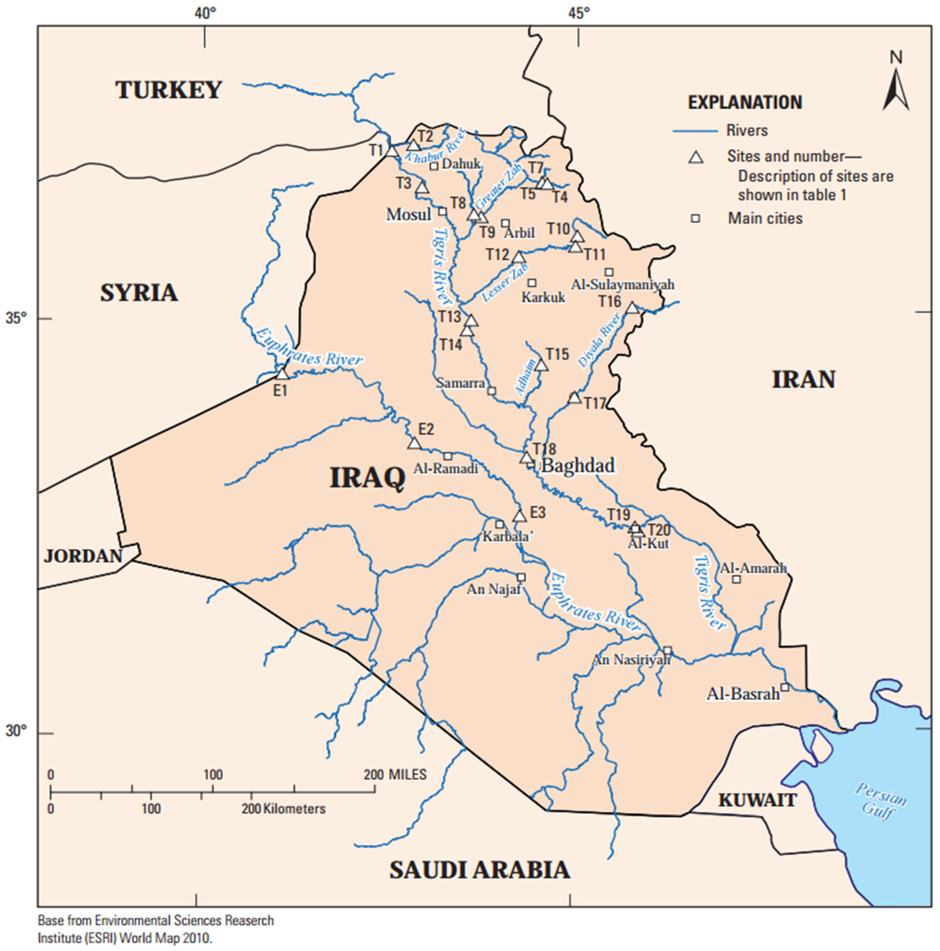
Figure 1. Tigris and Euphrates river basins with locations of streamflow-gaging stations, adopted from [10].
Water 17 01748 g001
Figure 2. The area percentage of (A) Tigris and (B) Euphrates River Basins, adopted and modified from [7].
Water 17 01748 g002
Figure 3. Percentage of annual flow from the mean of the long-term data adopted from [26].
Water 17 01748 g003
Figure 4. The Standardized Drought Index (SDI) for the main Tigris River at the Mosul site.
Water 17 01748 g004
Figure 5. The Standardized Drought Index (SDI) along the Euphrates River, Iraq (1933-2022).
Water 17 01748 g005
Figure 6. (A) Broad crested weir gauging station with radio telemetry; (B) automated Langemann gate [77].
Water 17 01748 g006
Figure 7. Water balance (resources versus demand).
Water 17 01748 g007
Figure 8. Unified platform with multi-dimensional system for sustainable water resource management, Tigris and Euphrates river systems, Iraq.
Water 17 01748 g008
Figure 9. Adaptive management of reservoir operation zones under conservation, flood, and drought scenarios.
Water 17 01748 g009
Figure 10. General framework of decision support system (DSS) for Tigris and Euphrates river basins, Iraq.
Water 17 01748 g010
Table 1. The main steps of the strategy plan.
CategoryDetails
(a) Objectives1. Food Security: Ensure adequate nutrition standards, considering population growth, declining soil conditions, and limited financial resources for food imports.
2. Internal Stability: Promote fair water distribution among stakeholders (farmers, industry, sanitation, environment), improve health standards, reduce local tensions, prevent migration, and ease pressures on local authorities.
3. International Relations: Avoid conflicts with riparian countries (Turkey, Iran, Syria) regarding Tigris and Euphrates water resources.
(b) Time Frame and StagingA 25-year strategy (up to 2050), divided into five 5-year stages with annual reviews for updating data and monitoring progress.
(c) Scenarios for Consideration1. Climate Change Scenarios: Account for potential impacts on water availability.
2. Water Sharing Scenarios: Consider scenarios with or without fair water-sharing agreements with riparian countries (Turkey, Iran, Syria).
(d) Introduction and Use of DSS1. Implement a Decision Support System (DSS) for water resource management.
2. Consider an updated strategy: limitations and possibilities. The installation will start immediately, with full automation by 2050.
Table 2. The main factors of the decision support system (DSS) are associated with the water resource management of the Tigris and Euphrates Rivers in Iraq.
FactorsDescriptions
Driving ForcesScarcity and limitation of water resources
Climate zone variability and climate change impact
Anthropogenic impact through excessive water withdrawal and inter-basin transfer
Urbanization and industrial expansion, agricultural water demands, and population growth
PressuresRainfall variations
Change in river flow regimes
Increased flash floods and successive drought years
Fulfilling the stakeholder’s water demands
Increased total evaporation losses
Environmental ecosystems
StateCurrent water resources’ status (quantity and quality)
ImpactsSurface and groundwater depletion
Water and food security
Soil salinity and land degradation
Increasing conflict over water allocation among provinces
Farmer and livestock migration
Fish farming, reed, and papyrus beneficiaries
Gross National Product (GNP)
Hydropower generation
Ecology and environmental diversity of rivers and marshes
Seawater intrusion into Shatt Al-Arab
ResponsesAdaptations and resilience strategies for climate change and anthropogenic impacts
Optimization of multi-purpose reservoir operation strategies
Evaluating the hydraulic structures and the requirement for new dams
Regulators and water harvesting
Flood, drought, and saltwater intrusion management
Enhancing irrigation systems and efficiency through the rehabilitation of and improvement in irrigation projects
Intelligent water infrastructure monitoring and management with SCADAs, in addition to water quality and environmental monitoring, integrating with remote sensing, GIS, and digital technologies.
Developing multi-hazard and early warning systems (EWSs) associated with water resource management
Reducing water encroachments
Enhancing treatments of drainage and wastewater outflow
Public awareness initiative for conservation of water resources
Strengthening institutional and legal frameworks for water management
Water governance and diplomacy through long-term agreements with riparian countries
Collaborating with international organizations
Consultation agencies, academic institutions, and private sector for sustainable water resources Management and development
Disclaimer/Publisher’s Note: The statements, opinions and data contained in all publications are solely those of the individual author(s) and contributor(s) and not of MDPI and/or the editor(s). MDPI and/or the editor(s) disclaim responsibility for any injury to people or property resulting from any ideas, methods, instructions or products referred to in the content.