Article

Attribution Analysis of Runoff Change in a Changing Environment: A Case Study of the Dawen River Basin

1
School of Mathematics & Computer Science, Wuhan Polytechnic University, Wuhan 430024, China
2
School of Water and Environment, Chang’an University, Xi’an 710064, China
3
Key Laboratory of Subsurface Hydrology and Ecological Effect in Arid Region of the Ministry of Education, Chang’an University, Xi’an 710064, China
4
Key Laboratory of Eco-Hydrology and Water Security in Arid and Semi-Arid Regions of Ministry of Water Resources, Chang’an University, Xi’an 710064, China
5
College of Environment and Life Sciences, Weinan Normal University, Weinan 714099, China
6
Key Laboratory for Ecology and Environment of River Wetlands in Shaanxi Province, Weinan Normal University, Weinan 714099, China
7
Powerchina Northwest Engineering Corporation, Xi’an 710065, China
*
Author to whom correspondence should be addressed.
Water 2025, 17(10), 1538; https://doi.org/10.3390/w17101538
Submission received: 7 April 2025 / Revised: 23 April 2025 / Accepted: 17 May 2025 / Published: 20 May 2025
(This article belongs to the Section Hydrology)

Abstract

:
Surface runoff change is significantly influenced by both human activities and climate change. Decoupling their respective contributions to runoff change represents a critical frontier in hydrological research and a pressing challenge for water resource management. This study focuses on the Dawen River Basin, a strategic area for ecological conservation and high-quality development in the lower Yellow River region. By integrating three methodological approaches—empirical models (Precipitation–Runoff Double Mass Curve), conceptual models (elasticity coefficient methods), and hydrological models (Soil and Water Assessment Tool, SWAT)—we systematically quantify the impacts of climate change and human activities on runoff change. A correlation analysis was first applied to screen independent runoff drivers and basin characteristic factors, followed by a random forest algorithm to rank their relative importance. This process informed the establishment of a comprehensive framework for runoff attribution analysis. Results demonstrate that hydrological modeling (SWAT) is the most appropriate method for the Dawen River Basin, revealing human activities as the dominant driver of runoff changes, accounting for 70% to 82%. These findings provide critical insights for guiding sustainable water resource planning and management in anthropogenically stressed basins under a changing environment.

1. Introduction

Since the 1950s, accelerated human socio-economic development has triggered significant global climate changes, primarily characterized by rising temperatures. In many regions, alterations in ice/snow melt and precipitation patterns have profoundly impacted water resources in terms of both quantity and quality [1,2]. Beyond climate change, human activities such as irrigation, afforestation, deforestation, and urbanization have further modified hydrological processes. For instance, afforestation reduces runoff [3]; urbanization increases surface runoff [4], shortens the lag time between precipitation and runoff (accelerating concentration times) [5], and amplifies peak flows [6]; and land use/cover changes significantly alter infiltration and evapotranspiration dynamics [7]. These interactions amplify hydrological extremes—including floods and droughts—generating unprecedented cascading risks to ecosystem integrity and regional socio-economic resilience [8,9,10,11,12,13,14,15,16]. Human interventions—including reservoir construction, urban water management, agricultural expansion, and urbanization—reshape hydrological processes, alter spatiotemporal water resource distributions, and interact in a complex manner with climate regulation [17,18,19]. The U.S. Geological Survey (USGS) recently updated its water cycle diagram after two decades, explicitly incorporating human activities [20]. This revision underscores the growing recognition of anthropogenic influences in hydrological research. Decoupling the contributions of human activities and climate change to runoff change has become a pivotal research topic [21,22]. As a critical component of the water cycle, runoff evolution profoundly influences water resource utilization across agriculture, industry, hydropower, and navigation. Researchers employ long-term runoff data to quantify variability and attribute total runoff changes to climate and human drivers within specific periods [23].
Most studies on quantifying the relative contributions of climate change and human activities to runoff variation focus on Chinese basins. For example, Xia et al. (2014) integrated Budyko hypothesis-based water–energy balance equations with the Penman-Monteith equation, revealing that human activities accounted for 87.4–89.5% of runoff reduction, substantially exceeding climate change’s 10.5–12.6% contribution [24]. In the Miyun Reservoir Basin, Ma et al. (2010) applied distributed hydrological and climate elasticity models, identifying climate change as responsible for 51–55% of runoff variation [25]. Zheng et al. (2009) used modified climate elasticity estimators in the Yellow River source region, attributing > 70% of runoff changes to LUCC and <30% to climate factors [26]. Wang et al. (2013) analyzed four sub-basins in the Haihe River Basin using hydrological sensitivity analysis, models, and elasticity methods, concluding that human activities dominated runoff reduction in three sub-basins, while climate change prevailed in the fourth [27]. International studies also highlight regional variability: Poelmans et al. (2011) linked 30% of runoff changes in central Belgium to climate via rainfall–runoff models [28]; D’Agostino et al. (2010) projected a 16–23% decline in runoff by 2050 in southern Italy’s Canale d’Aiedo Basin using hydrological models [29]; and Saidi et al. (2018) attributed 85% of alpine river runoff reduction in northwestern Italy to climate change using sensitivity and elasticity methods [30]. These divergent outcomes underscore the challenge of disentangling climate–human interactions, necessitating localized investigations. Current research predominantly relies on single-method approaches (e.g., hydrological model) to assess relative impacts, while multi-method evaluations remain rare. Few studies systematically analyze methodological applicability across basins, particularly for immediate human drivers (e.g., water abstraction, reservoir operations) whose impacts vary regionally. A standardized framework for method selection based on basin-specific characteristics is urgently needed.
The term “changing environment” in this study refers to both climate change and human activities. Mounting evidence confirms their synergistic effects on hydrological cycles [31,32,33,34,35,36], though spatial heterogeneity in these impacts reflects geographic and socioeconomic disparities [37]. Human activities fall into three categories: LUCC, reservoir operations, and water abstraction. Unsustainable practices—such as irrational land use, unregulated water abstraction, and poorly managed hydraulic infrastructure—exacerbate soil erosion, land degradation, water scarcity, and flood risks. Thus, comprehending the anthropogenic impacts on runoff is central to sustainable watershed management and water resource planning.

2. Materials and Methods
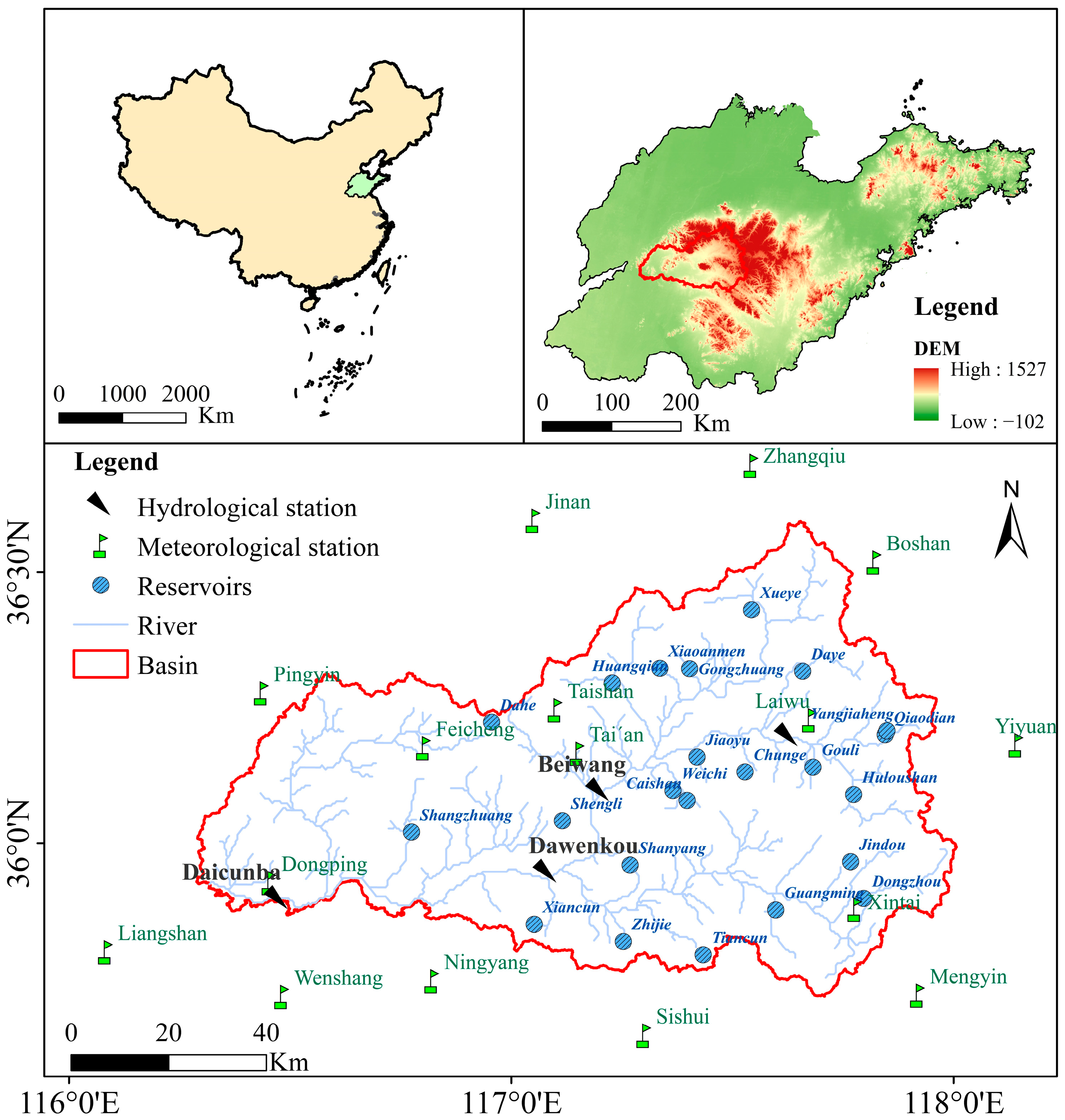
2.1. Study Area

The Dawen River, the largest tributary in the lower reaches of the Yellow River and one of China’s rare east-to-west flowing rivers, primarily traverses Laiwu City and Tai’an City in Shandong Province (Figure 1). With a total length of 231 km and a drainage area of 8944 km2, its upper reaches flow through mountainous and hilly terrain, while the middle-lower reaches form a plain before eventually converging into Dongping Lake. Dongping Lake, the sole crucial flood detention basin in the Yellow River Basin, functions as a key regulation hub for the South-to-North Water Diversion Project’s eastern route and the source of Shandong’s Jiaodong Water Transfer Project. The natural evolution of the Dawen River Basin has been profoundly altered by human activities including agricultural expansion, hydraulic engineering, and urbanization. With a land utilization rate approaching saturation, agriculture dominates the basin, encompassing wheat, corn, orchards, vegetable fields, and cash crops like peanuts and cotton. Since the 1950s, large-scale water conservancy projects have significantly altered the natural hydrological rhythms. By 2019, the basin accommodated 23 large and medium-sized reservoirs (mostly upstream) and over 100 small ones. These structures reduced downstream flood volumes by approximately 60%, drastically lowered sediment loads, diminished natural sediment transport capacity, and triggered elevated riverbed phenomena in certain reaches. The Dongping Lake Reservoir, constructed in 1958, plays a dual role in regulating floods from both the Dawen River and the Yellow River, accounting for 60% of the annual regulated runoff. In Tai’an’s water supply system, large-scale projects such as reservoirs, sluice gates, and pumping stations contribute 83.9% (872 million m3) of total supply, underscoring heavy reliance on surface water [38]. While modern irrigation infrastructure enhances efficiency, it exacerbates upstream–downstream conflicts—for instance, reduced ecological flow in plains due to upstream reservoir interception. The famed “Wenyang Farmland”, renowned for irrigation agriculture since antiquity, traces its water management legacy to the Yuan Dynasty’s water diversion projects and the Ming–Qing period’s “storage-regulation integration” philosophy embodied in the Daicunba. These historical strategies continue to influence contemporary flood control paradigms. The Dawen River Basin stands as an ideal region for studying runoff evolution under changing environments, offering insights into the interplay between anthropogenic interventions and hydrological dynamics.

2.2. Data

  • DEM Data
The digital elevation model (DEM) data for the Dawen River Basin were obtained from the China Geospatial Data Cloud platform, with a 30 m spatial resolution in GeoTIFF format. The raw elevation data underwent standardized preprocessing by using ERDAS IMAGINE 2023 (Hexagon Geospatial, Switzerland), including coordinate system unification and outlier removal, before being converted to the hierarchical data format (HDF5) for subsequent hydrological modeling.
  • Hydrometeorological Data
The Dawen River Basin runoff data are monthly runoff series covering the period from 1961 to 2019, obtained from four hydrological stations, Laiwu, Beiwang, Dawenkou and Daicunba. These data were acquired from the Shandong Provincial Hydrology Center. The meteorological dataset consists of daily observations spanning the years 1961 to 2019 from 16 meteorological stations within and around the Dawen River Basin, including precipitation, temperature (mean/maximum/minimum), wind speed at 2 m elevation, sunshine duration, and relative humidity. These data were obtained from the National Meteorological Information Center of the China Meteorological Administration (CNMA) and from the Climate Data from the Climate Information Center of the National Meteorological Information Center of the China Meteorological Administration (CMA). The data are primarily utilized for the analysis of the influencing factors of runoff change characteristics and model-driven raw data input. The dataset serves a dual purpose: ① diagnostic analysis of hydroclimatic drivers influencing water resource variability, and ② providing high-temporal-resolution forcing inputs for hydrological models.
  • Soil Data
Soil data for the Dawen River Basin were obtained from the Harmonized World Soil Database (HWSD; https://www.fao.org/soils-portal/data-hub/soil-maps-and-databases/harmonized-world-soil-database-v12 (accessed on 29 March 2025)), a global 1:1,000,000-scale spatial dataset, constructed by the Food and Agriculture Organization of the United Nations (FAO) and the International Institute for Applied Systems Analysis (IIASA). The soil type map of the Dawen River Basin was cropped using ArcGIS, with classification according to the FAO-90 system.
  • Land Use Cover Data
The multi-temporal land use raster dataset (30 m spatial resolution) for the study watershed was obtained from the Resource and Environmental Science and Data Center (RESDC) (https://www.resdc.cn (accessed on 5 April 2024)) of the Chinese Academy of Sciences, covering seven epochs (1980, 1990, 2000, 2005, 2010, 2015, and 2018). This dataset originates from the 1:100,000 National Land Use/Cover Database of China, developed through systematic interpretation of Landsat TM/OLI imagery combined with ground-truth validation and historical geographic archives.
  • Reservoir data
Due to data availability constraints, three reservoirs were selected for analysis: Guangming Reservoir (large-scale) and Huangqian and Dongzhou Reservoirs (medium-sized). The hydrological dataset of reservoirs in the Dawen River Basin primarily comprises fundamental parameters, monthly outflow records, operational data, and storage capacity of Dongzhou Reservoir, Guangming Reservoir, and Huangqian Reservoir. The fundamental parameters are from the compilation of three investigations and three determinations for large and medium-sized reservoirs in Shandong Province. The monthly outflow data of each reservoir was obtained from the Shandong Hydrological Center. The reservoir operation data and water storage volume were obtained from the reservoir management bureau, reflecting monthly water abstraction by users and reservoir regulation outcomes.
  • Consumptive water
The consumptive water data from 1987 to 2019 were primarily sourced from the Shandong Province Water Resources Bulletin, Tai’an City Water Resources Bulletin, and Laiwu City Water Resources Bulletin. Data for the period 1961–1986 were derived from comprehensive data collection and investigative analysis. The dataset covers administrative divisions within the Dawen River Basin (Taishan District, Daiyue District, Xintai City, Feicheng City, Ningyang County, Dongping County, Pingyin County, and Laiwu City), categorized under two classification frameworks: ① Usage categories: Agricultural, industrial, domestic, and ecological–environmental water supplementation. ② Source classifications: Surface water and groundwater (subdivided into shallow and deep aquifers).

2.3. Methods

2.3.1. Runoff Change Attribution Methodology

(1)
Precipitation–Runoff Double Mass Curve
The Double Mass Curve (DMC) was initially derived to assess the consistency of meteorological data in the Susquehanna River Basin [39,40]. River runoff is predominantly influenced by both human activities and climate change. To isolate the contribution of human activities by eliminating climate-induced variations (with precipitation serving as the primary manifestation of climate change), the Precipitation–Runoff Double Mass Curve method has been widely adopted [41,42]. This method divides hydrological series into two distinct periods based on runoff abrupt points: the Natural Period, which is characterized by minimal anthropogenic interference, where runoff is primarily driven by climate variability; and the Human Activity Period, marked by significant anthropogenic impacts, during which runoff reflects combined effects of climate change and human activities. The DMC quantitatively evaluates these impacts by plotting cumulative precipitation (independent variable) against cumulative runoff (dependent variable). A stable linear relationship in the curve indicates negligible human influence on runoff, whereas a slope change or deviation from linearity signifies altered hydrological dynamics due to anthropogenic interventions. This approach enables the attribution of runoff variations to either climatic factors or human actions, providing critical insights for watershed management and ecological restoration. The specific steps are as follows:
  • Establish Cumulative Precipitation–Runoff Linear Regression Equations
The hydrological series is partitioned into a baseline period and a human activity period based on runoff abrupt points. Linear regression equations are formulated for cumulative precipitation (independent variable) and cumulative runoff (dependent variable) before and after the abrupt point, expressed as follows:
Precipitation–Runoff Double Mass Curve (DMC):
R o r i g = a 1 P o r i g + b 1
In the equation above, R o r i g and P o r i g denote measured runoff and precipitation in the natural period, respectively; a1, b1 represent constant terms.
A regression Equation (1) was established using the pre-abrupt-point-year double mass curve of measured precipitation–runoff relationships. The cumulative measured precipitation series from the post-abrupt-point period was then input into this equation to calculate the reconstructed theoretical cumulative runoff series. The difference between measured and theoretical runoff values during the human activity period was quantified as the contribution of human activities to runoff variation.
  • Quantification of Runoff Change Attribution
The theoretical runoff values during the human activity period are calculated as follows:
R v a r R e c = a 1 P v a r + b 1
Δ R = Δ R C + Δ R H = R v a r R o r i g Δ R C = R v a r R e c R o r i g Δ R H = Δ R Δ R C = R v a r R e c R v a r ζ C = Δ R C Δ R × 100 % ζ H = 1 ζ C = Δ R H Δ R × 100 %
In Equations (2) and (3), R v a r Re c and R v a r denote the reconstructed theoretical runoff and measured runoff during the human activity period, respectively; Δ R represents the total runoff variation induced by environmental changes; Δ R C , Δ R H represents runoff variations attributed to climate change and human activities, respectively; R o r i g represents the measured runoff during the natural period (mm); ζ C , ζ H represent the contribution rates (%) of climate change and human activities to runoff change, respectively.
  • Evaluation Index
The coefficient of determination (R2) was employed to assess the performance of the Precipitation–Runoff Double Mass Curve. A threshold of R2 > 0.6 indicates that the regression equation is representative, with values closer to 1 signifying stronger precipitation–runoff correlations.
(2)
Elasticity Coefficient Method
The elasticity coefficient method based on the Budyko framework was employed to disentangle the impacts of human activities and climate change on runoff change. This approach utilizes the water balance equation, with precipitation and potential evapotranspiration as climatic factors, to compute the sensitivity of runoff to climatic change and subsequently quantify their contributions.
Long-term water balance equation based on the Budyko hypothesis:
R = P E Δ Q
In Equation (4), R denotes the runoff; P denotes the precipitation; E denotes the actual evapotranspiration; and Δ Q represents the watershed water storage change, assumed to be negligible over long-term periods.
Runoff can be expressed as a function of climatic factors (P, E0) and watershed characteristics (V):
R = f C , H = f P , E 0 , V
In Equation (5), C, H denote the contributions of climate change and human activities to runoff change; E 0 denotes the potential evapotranspiration (calculated via the Penman–Monteith equation); V represents the watershed characteristic parameter (integrating topography, land cover, and subsurface properties).
The climate-induced runoff change Δ R C is defined as follows:
Δ R C = f P Δ P + f E 0 Δ E 0 = R P Δ P + R E 0 Δ E 0
Runoff Elasticity to Climatic Factors ε :
ε = R R / X X
In Equation (7), X represents climatic factors (P, E0). Rewriting Equation (6) using elasticity coefficients gives the following:
Δ R C = Δ R P + Δ R E 0 = ε P Δ P P + ε E 0 Δ E 0 E 0 R
The ratio of actual evapotranspiration to precipitation (E/P) is expressed as a function of the aridity index (Budyko hypothesis integration):
F φ = E P
Combining Equations (4) and (9), the elasticity coefficients for P and E0 are derived:
ε P = 1 + φ F ( φ ) 1 F ( φ ) ε E 0 = φ F ( φ ) 1 F ( φ ) ε P + ε E 0 = 1
The relative contribution of climate change and human activities to runoff change are calculated as follows:
ζ C = Δ R C Δ R × 100 % ζ H = 1 ζ C
The method hinges on determining the F φ . This study adopted seven Budyko-type formulations (Table 1) to quantify the contributions of climate change and human activities to runoff change. The first four methods are parameter-free, while the latter three are parameterized. Multiple methods from each category were selected for cross-comparison to validate the results.
(3)
Hydrological model
The Dawen River Basin was modeled using the Soil & Water Assessment Tool (SWAT), with an input database comprising DEM, soil data, meteorological data, LUCC data, reservoir data, and consumptive water use data within the basin. The modeling time scale was divided into two phases based on an abrupt-point year (mutated year): the natural period (pre-abrupt-point phase, human activity is minimal and the period is assumed to be natural) and the human activity period. Two models were constructed: the natural model S1 for the natural period and the abrupt-period model S2 (with scenarios A1, A2, A3, and A4) for the human activity period (Table 2). Full model construction specifics are detailed in Appendix B.1. SWAT-CUP is a program for calibration of SWAT models, employed to perform bidirectional calibration and validation of model parameters across different periods. Time-partitioned modelling enhances performance, with detail results provided in Appendix B.2.
We then input the hydrometeorological data corresponding to the human activity period (post-abrupt-point years) into Model S1 to reconstruct the natural river runoff data not affected by human activities. The simulation scenarios are configured as detailed in Table 3.
The difference in simulated runoff value between the pre- and post-abrupt-point years (i.e., the natural period and human activity period) is attributed to climate change. The discrepancy between the observed runoff data and reconstructed runoff data during the human activities period is attributed to human activities. Based on the above scenario settings, a quantitative separation of climate change and human activity impacts is performed.
Contribution of climate change to runoff change:
Δ R = Δ R C + Δ R H = R v a r R o r i g Δ R C = R v a r , s i R e c R o r i g ζ C = Δ R C Δ R × 100 %
Contribution of human activities to runoff change:
Δ R H = Δ R Δ R C = R v a r , s i R e c R v a r , s i ζ H = 1 ζ C = Δ R H Δ R × 100 %
In the equation above, R var , s i Re c denotes reconstructed runoff during the human activity period Si, i = 1,2,3,4.
This study utilizes hydrological models to quantitatively separate the contributions of human activities and climate change to runoff change. Building on this foundation, it further separates the amount of contribution of each human activity to runoff change, which are LUCC, reservoir operation, consumptive water, and other anthropogenic factors. The human activity period (1977–2019) is divided into four periods: 1977–1990, 1991–2000, 2001–2010, and 2011–2019. Corresponding baseline models (A1, A2, A3, and A4) are established for each period. By designing appropriate scenarios based on these baseline models, the impacts of LUCC, reservoir operations, and consumptive water use activities on runoff change can be separated.
Initially, the baseline model of four periods was established, with the input data comprising the corresponding hydrometeorological data, land use/cover data, reservoir operation data, and consumptive water use data of each era. Subsequently, the baseline model of each era was utilized as the benchmark, and the consumptive water and reservoir operation were sequentially stripped off, with the model being run. The specific separation of each human activity scenario setting is shown in Table 4. The impact of each human activity component is calculated as follows:
Δ R u s e r = R ( A m , 1 ) R ( A m ) Δ R r e s = R ( A m , 2 ) R ( A m , 1 ) Δ R L U C C = R ( A m , 3 ) R ( A m , 2 ) Δ R O t h e r = Δ R H Δ R u s e r Δ R r e s Δ R L U C C
where R ( A m , i ) represent the simulated runoff volume for multiple scenarios corresponding to each era using A1–A4 as the baseline model; Δ R u s e r represents the impact of consumptive water use activities on the runoff change; Δ R r e s indicates the impact of reservoir operation on the runoff change; and Δ R L U C C represents the impact of land use/cover on the runoff change. Δ R O t h e r denotes the impact of other human activities on the runoff change.
Calculation of the contribution of each human activity to runoff change:
ζ u s e r = Δ R u s e r Δ R H × ζ H × 100 % ζ r e s = Δ R r e s Δ R H × ζ H × 100 % ζ L U C C = Δ R L U C C Δ R H × ζ H × 100 % ζ O t h e r = Δ R O t h e r Δ R H × ζ H × 100 %
where ζ u s e r , ζ r e s , ζ L U C C and ζ O t h e r represent the contribution of consumptive water activities, reservoir operation, land use/cover change, and other human activities, respectively, to runoff change.

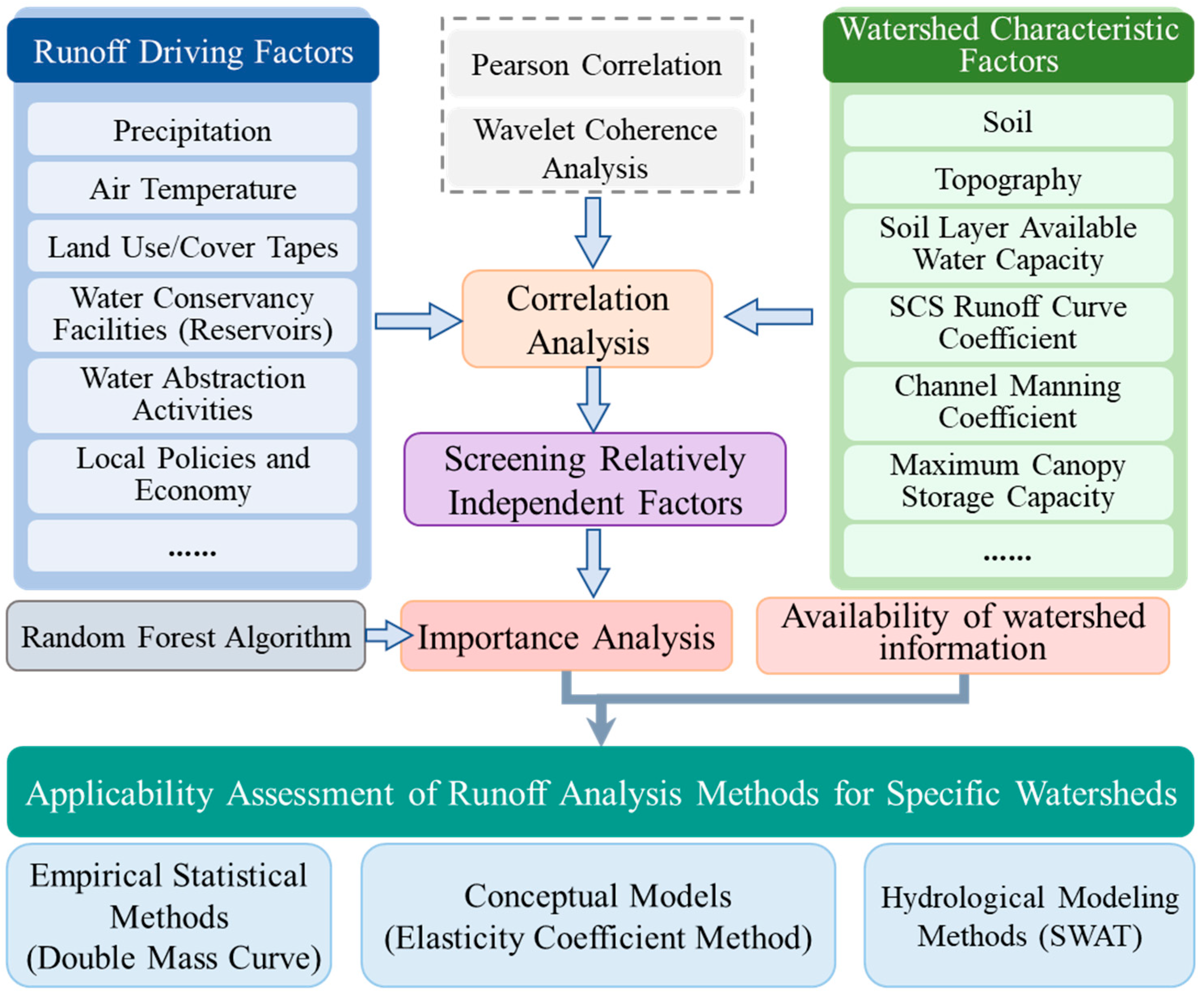
2.3.2. Framework for Adaptability Assessment of Runoff Change Attribution Methods

Runoff generation arises from complex hydrological processes influenced by both driving factors and basin-specific attributes. Existing runoff attribution methods diverge in their selection of driving factors and basin characteristics, often prioritizing limited parameters. Evaluating parameter significance thus serves as a critical metric for assessing the applicability of these methods across heterogeneous basins. The random forest algorithm, which partitions data into random subsets to identify optimal feature variables, exhibits superior integrative performance and is widely adopted for quantifying the relative importance of drivers (e.g., runoff, water quality).
This paper employs three types of approaches, namely the empirical statistical method (exemplified by the Precipitation–Runoff Double Mass Curve), the conceptual model method (represented by the elasticity coefficient), and the hydrological model method (represented by SWAT), to quantitatively separate whether the dominant factor influencing runoff change is climate change or human activities. To evaluate their basin-specific applicability, a framework is established based on parametric significance (Figure 2). First, a comprehensive set of runoff drivers and basin characteristics is selected. Pearson correlation and wavelet coherence analyses are applied to filter statistically independent variables. Subsequently, random forest is utilized to rank the relative importance of factors in explaining runoff change, thereby systematically assessing the suitability of each attribution method within the study basin.

3. Results and Discussion

3.1. Delineation of Baseline and Change Periods

The representative indicators for climate change were selected as precipitation and temperature. Time series of climate indices (including 27 extreme climate indices calculated using RClimDex, based on daily-scale mean precipitation, mean temperature, daily maximum and minimum temperatures) were subjected to abrupt change detection using multiple statistical methods (Mann–Kendall test, Pettitt test, cumulative anomaly analysis, and Regime Shift Detection; see the referenced literature [43] for details). The results indicated that the abrupt change in precipitation-related indices predominantly occurred during the mid-to-late 1970s, while the abrupt change in temperature-related indices clustered in the late 1980s. In the Dawen River Basin, most large-to-medium reservoirs were constructed between the 1960s and 1970s, with expansions or retrofits completed in the 1970s. Regional water consumption stabilized after the 1990s, driven by economic development and policy adjustments. Runoff data from four hydrological stations (Laiwu, Beiwang, Dawenkou, and Daicunba) along the upper to lower reaches exhibited abrupt transitions between 1975 and 1977 [44]. The S1 model simulations generated 1961–2019 runoff series for all sub-basins (Figure 3). Observed and simulated runoff exhibited strong consistency before the 1976 change point, while simulations systematically overestimated observed values post-1976. Synthesizing these findings, 1976 was identified as the abrupt year. Consequently, the baseline period was defined as 1961–1976, and the change period as 1977–2019.

3.2. Precipitation–Runoff Double Mass Curve

This study constructed double mass curves using observed precipitation and runoff data (1961–2019) from the Dawen River Basin. Four sub-basins—Laiwu, Beiwang, Dawenkou, and Daicun Dam—spanning the upper to lower reaches were selected. Area-weighted average precipitation within each station’s sub-basin was calculated via the Thiessen polygon method, and station-specific Precipitation–Runoff Double Mass Curves were established. The study period was divided into a baseline period (S1: 1961–1976) and a human activity period (S2: 1977–2019), with S2 further segmented into four sub-periods: A1 (1977–1990), A2 (1991–2000), A3 (2001–2010), and A4 (2011–2019).
As shown in Figure 4, regression equations for the baseline period exhibited high explanatory power (R2 = 0.92–0.98), confirming robust linear relationships between cumulative precipitation and runoff. Quantitative separation of climate change and human activities impacts using the double mass curve method (Table A1, Figure 5) revealed consistent runoff reductions across all sub-basins during S2 compared to S1. Human activities accounted for 77%, 78%, 53%, and 72% of runoff change (1977–2019) at the four sub-basins, respectively, underscoring their dominant role in the basin. Notably, the A3 period (2001–2010) exhibited anomalous contributions, likely due to extensive retrofitting of water conservancy projects—particularly in the Dawenkou sub-basin, where human activities contributed −70% to runoff changes, reflecting heightened engineering interventions. These results demonstrate that human activities are the primary driver of runoff change in the Dawen River Basin, highlighting significant human-induced hydrological modifications.

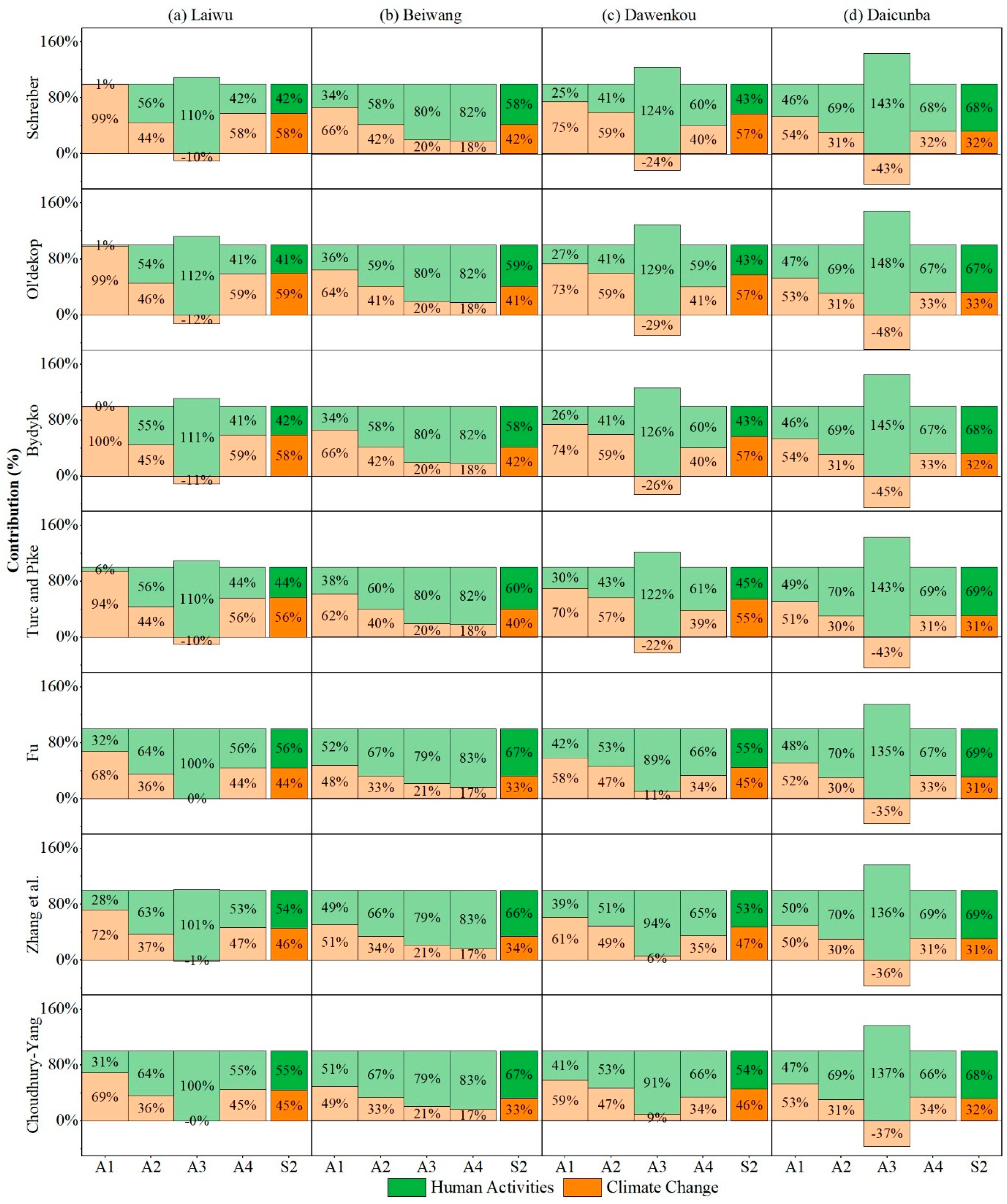
3.3. Elasticity Coefficient Method

This study utilized observed precipitation and runoff data (1961–2019) along with potential evapotranspiration (ET0) calculated via the Penman–Monteith formula in the Dawen River Basin. Seven Budyko hypothesis-based elasticity coefficient methods were employed to quantitatively assess the impacts of climate change and human activities on runoff change (Table A2, Figure 6). Non-parametric elasticity methods revealed that a 1% decrease in precipitation would reduce runoff by 2.51–2.90%, while a 1% increase in potential evapotranspiration would decrease runoff by 1.51–1.90%. Parametric elasticity methods indicated that a 1% precipitation reduction led to runoff declines of 1.75–2.91%, whereas a 1% potential evapotranspiration increase resulted in runoff reductions of 0.75–1.91%.
For the Laiwu sub-basin, climate change dominated runoff change during the full study period (S2, approximately 58%). During period A1, climate change accounted for >94% of runoff changes using non-parametric methods and approximately 70% via parametric methods. Human activities became predominant in A2 (non-parametric: approximately 55%; parametric: approximately 64%) and overwhelmingly dominated A3. Divergent results emerged in A4, with non-parametric methods implicating climate change while parametric methods identified human activities as primary. In the Beiwang sub-basin, human activities dominated S2 runoff changes (58–67%). All seven methods demonstrated increasing human activities contribution from A1 (34–52%) to A4 (82–83%). For the downstream sub-basins (Dawenkou and Daicunba), the influence of human activities progressively intensified from A1 to A2 and A4, while completely dominating A3. In S2, non-parametric methods attributed Dawenkou’s runoff changes primarily to climate change (57%) versus parametric methods emphasizing the impact of human activities (54%). Daicunba’s S2 runoff changes were predominantly human-driven (approximately 68%).
Collectively, human activities constituted the primary driver of runoff change in the Dawen River Basin. While climate change dominated during A1, anthropogenic factors prevailed in A2–A4, with escalating influence of human activities over time. Non-parametric methods generally yielded higher climate change contributions than parametric approaches across identical spatiotemporal scales, reflecting parametric methods’ enhanced incorporation of underlying surface conditions.

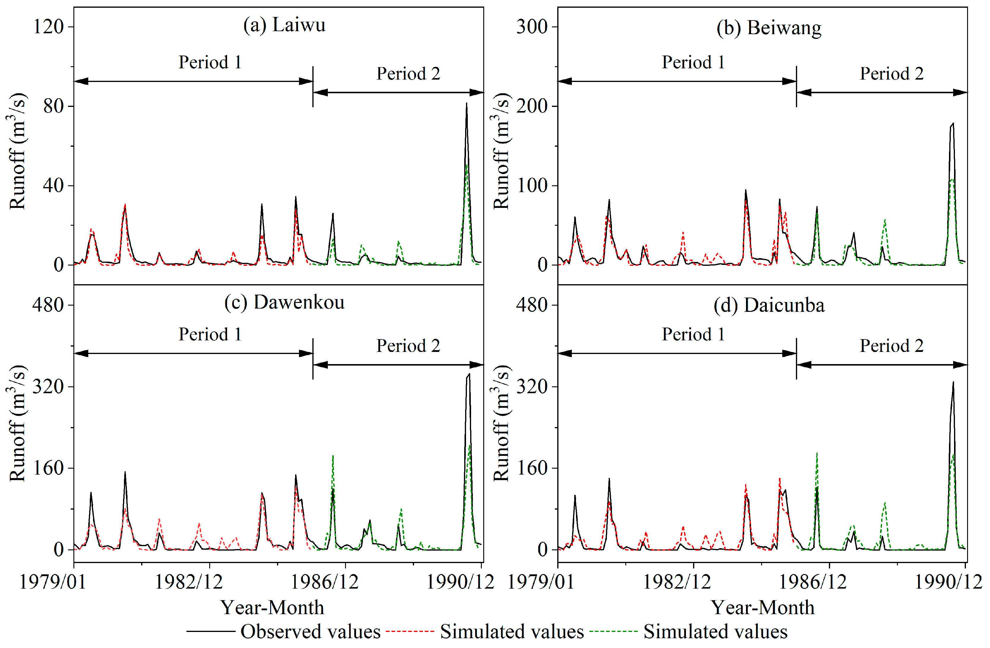
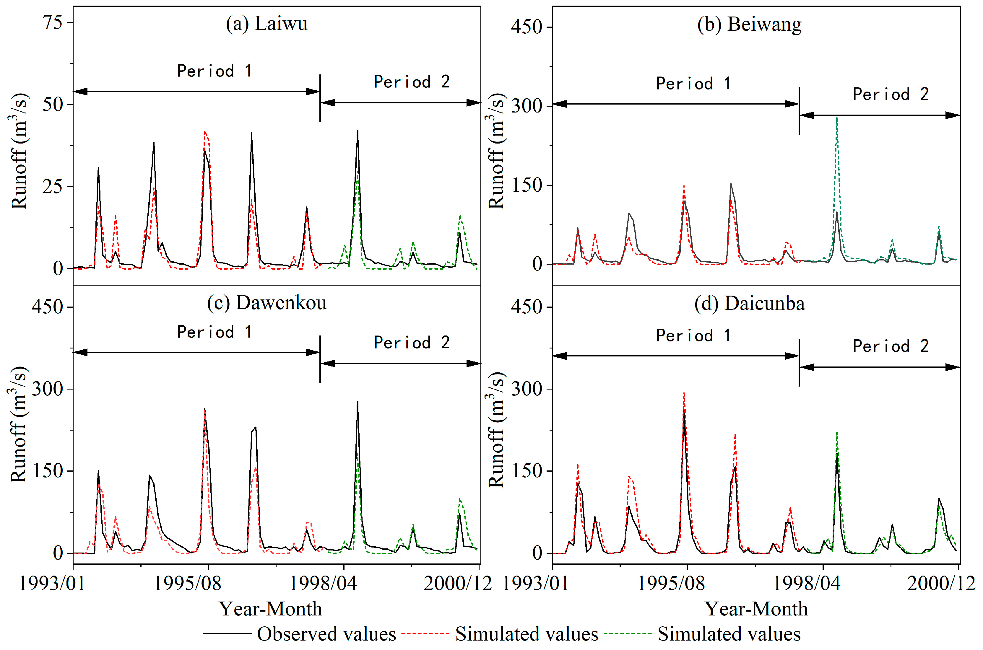
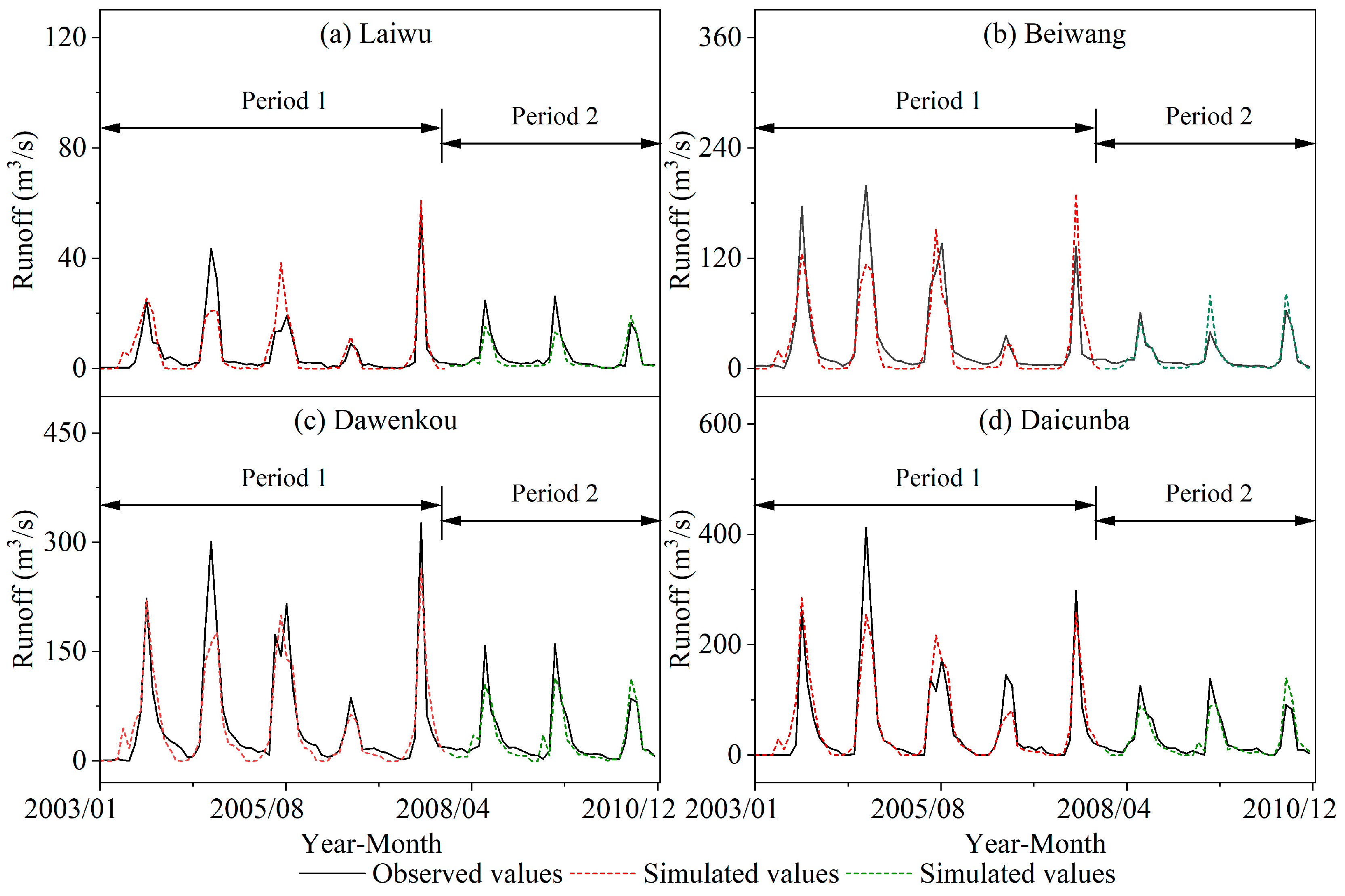
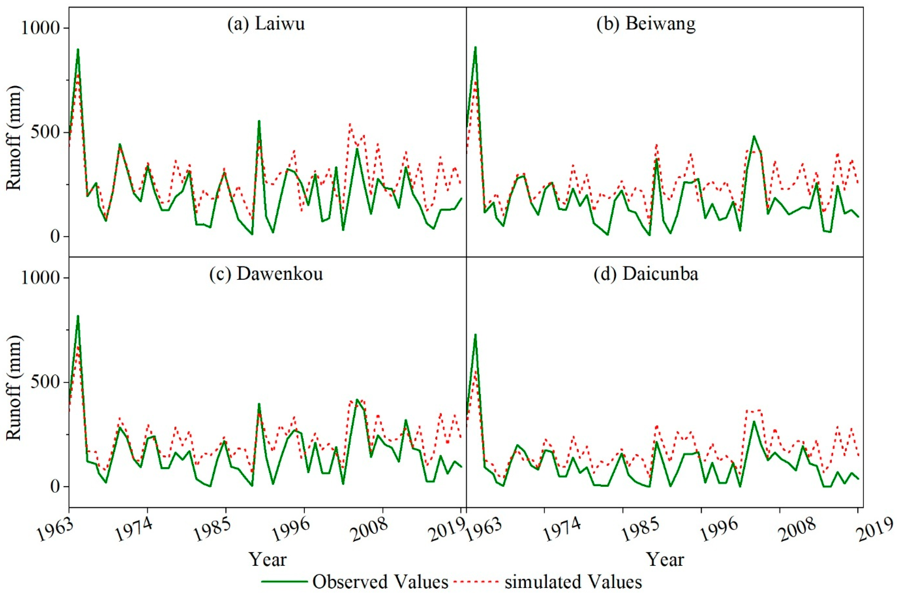
3.4. Hydrological Model

(1)
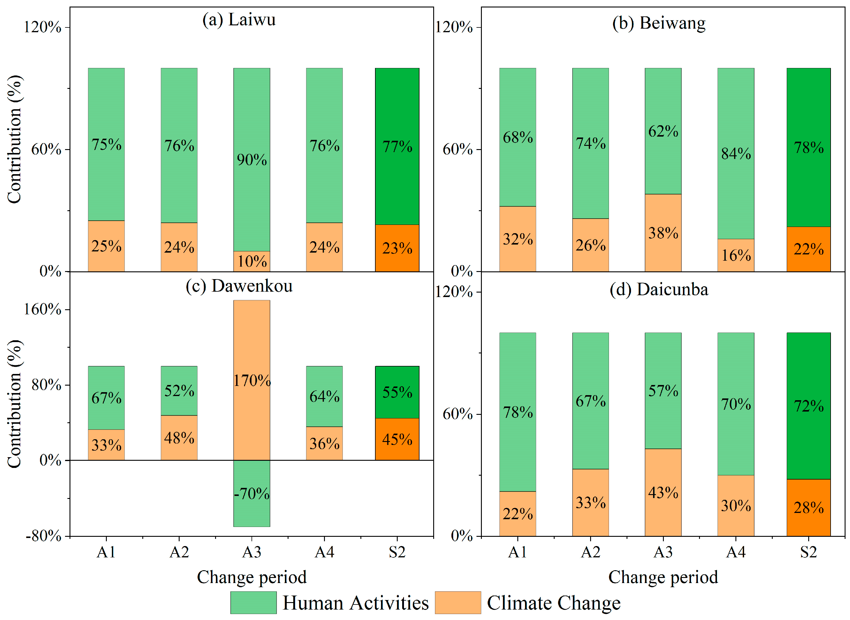
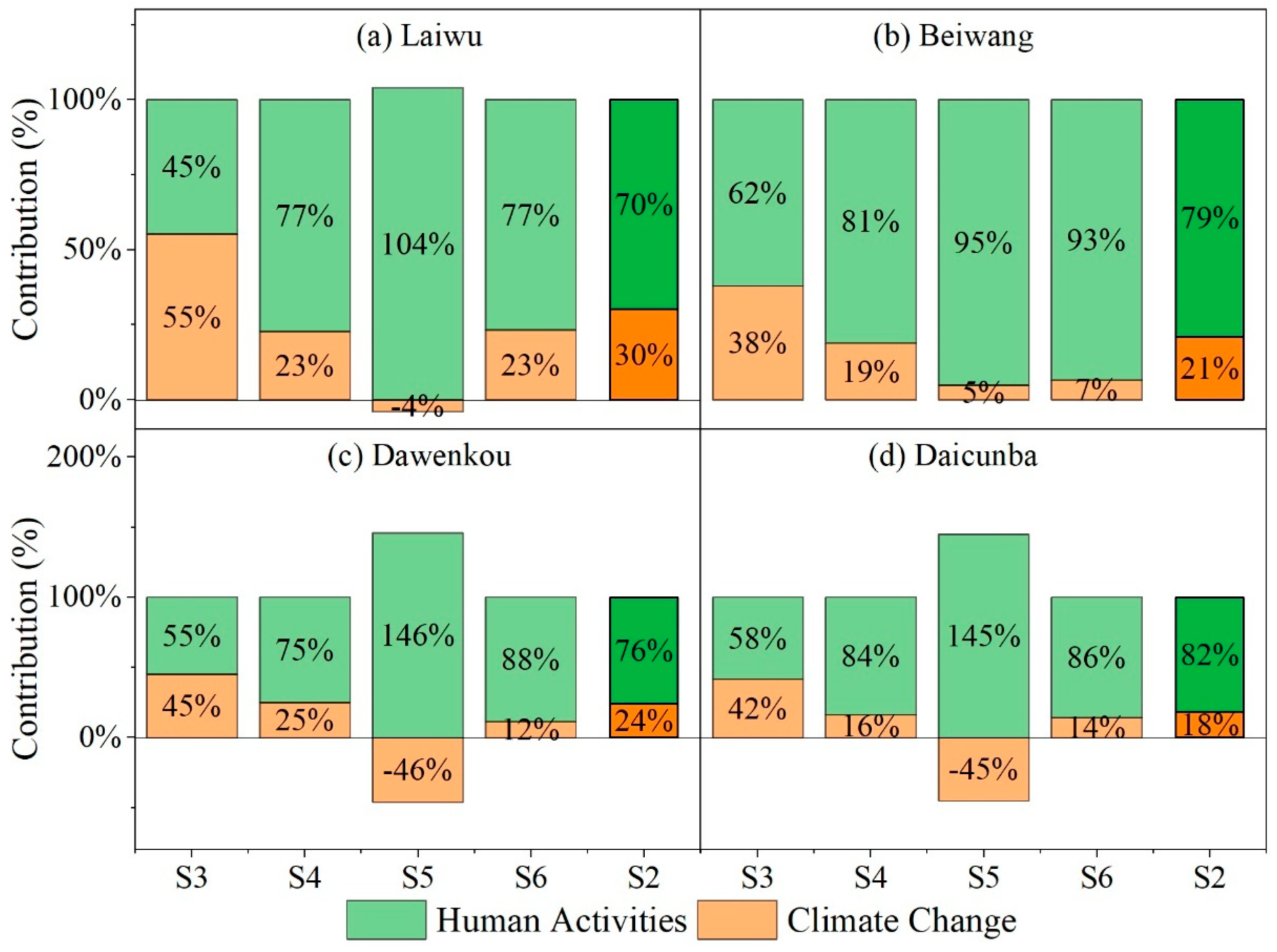
Separation of Climate Change and Human Activity Contributions to Runoff Changes
The quantitative contributions of climate change and human activities to runoff changes during the change period are summarized in Table A3 and Figure 7. In the S2 period, human activities dominated runoff changes across all four sub-basins, accounting for 70–82%. Excluding the S5 period, the proportional impact of human activities progressively increased during the S3, S4, and S6 periods. Notably, runoff changes during S5 were almost entirely driven by human activities (contributing > 95%), attributed to intensified anthropogenic disturbances near the Dawenkou hydrological station, which is situated at the confluence of the southern tributary of the Dawen River Basin. These results collectively demonstrate a temporal escalation in the influence of human activities, particularly over the past two decades, during which their contributions consistently exceeded 77%.
(2)
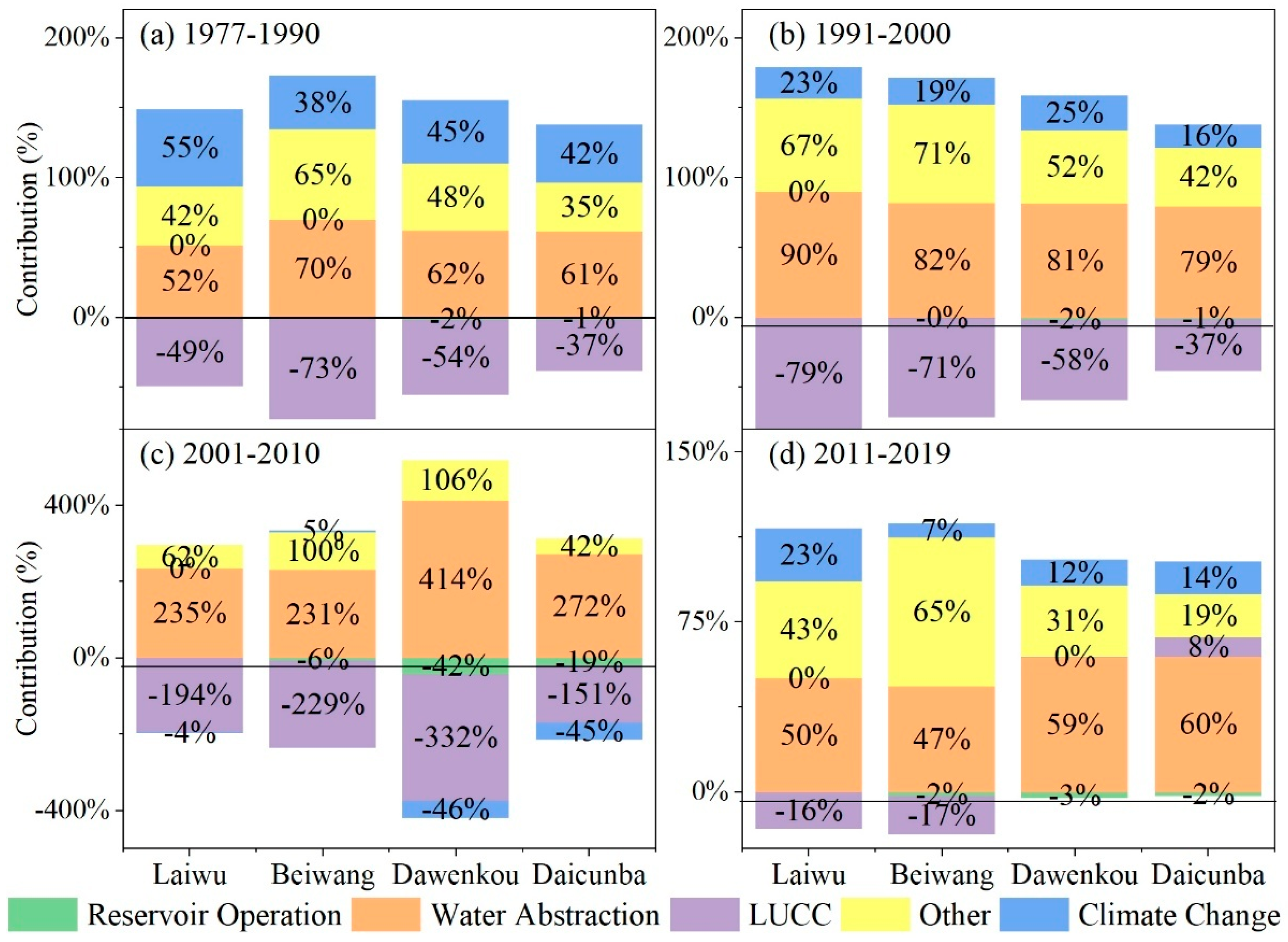
Separation of Human Activity-Specific Contributions to Runoff Changes
As established, human activities dominate runoff changes in the Dawen River Basin. To quantify the contributions of specific anthropogenic drivers, scenario modeling (Table 4) was implemented to disentangle impacts from water abstraction and consumption, reservoir operation, LUCC, and other human activities, with results summarized in Table A4 and Figure 8. Among these drivers, water consumption activities and other human activities exerted positive contributions (amplifying runoff reduction), primarily driven by water consumption activities, while reservoir operation and LUCC showed negative contributions (mitigating runoff reduction), dominated by LUCC followed by reservoir operation. Temporally, all human activities drivers exhibited an initial increase followed by a decline in their contributions, peaking during 2001–2010 and reaching minimal levels in 2011–2019. Specifically, water abstraction contributed 52–70% (1977–1990), 79–90% (1991–2000), and 47–60% (2011–2019), but surged anomalously to 231–414% during 2001–2010. Reservoir operation showed modest contributions (−2% to −1%) in 1977–1990, 1991–2000, and 2011–2019, but reached −42% and −19% at Dawenkou and Daicunba sub-basins during 2001–2010. LUCC contributed −49% (1977–1990) and −79% (1991–2000) at Laiwu sub-basin, while other sub-basins displayed comparable values: [−71%, −73%], [−54%, −58%], and [−37%, −37%] for these periods, escalating to −332–−151% during 2001–2010, before declining to −16–8% post-2010. Other human activities exhibited contributions of 35–65% (1977–1990), 42–71% (1991–2000), 42–106% (2001–2010), and 19–65% (2011–2019). Temporal variations in anthropogenic contributions may be attributed to the following: (1) post-1990 shifts in water abstraction and consumption patterns due to enhanced public water conservation awareness; (2) stringent water resource management policies implemented since 2002; (3) limited regulatory capacity of reservoir operation under low precipitation conditions (2011–2019); and (4) cumulative impacts of small-scale hydraulic infrastructure, particularly dams along main channels.

3.5. Integrated Comparison of Tri-Method Results

This study employed three methodological approaches—an empirical statistical model (Precipitation–Runoff Double Mass Curve), a conceptual model (elasticity coefficient method), and a hydrological model (SWAT)—to quantitatively separate the contributions of climate change and human activities to runoff changes. A comprehensive comparison of results from these methods is illustrated in Figure 9. All approaches consistently identified human activities as the dominant driver of runoff changes across the Dawen River Basin, aligning with previous findings in this basin [45].
During the 1977–1990 period, both the double mass curve method and SWAT model unequivocally demonstrated that human activities contributed substantially more to runoff reduction (67–78% and 45–62%, respectively) than climate change (22–33% and 38–55%). However, the elasticity coefficient method yielded divergent results, attributing runoff decline primarily to climate change, with human activity contributions calculated via non-parametric Budyko-based methods (2–51%) markedly lower than those from parametric approaches. This discrepancy likely stems from differences in mechanistic assumptions and parameterization schemes among methods, underscoring the profound influence of methodological choices on conclusions.
From 1991 to 2000, all three methods converged in identifying human activities as the principal driver of runoff reduction. The double mass curve and SWAT model showed human activity contributions (52–76% and 75–84%) vastly exceeding those of climate change (24–48% and 16–25%), with slightly stronger anthropogenic impacts observed upstream. While the elasticity coefficient method also supported human activities as dominant, non-parametric Budyko-based calculations yielded lower human activity contributions (42–70%) than parametric methods, reaffirming systematic methodological disparities.
The 2001–2010 period revealed pronounced spatial heterogeneity in double mass curve results across the sub-basin. Upstream-to-downstream gradients in human activity contributions were observed at Laiwu (91%), Beiwang (62%), and Daicunba (57%), whereas Dawenkou exhibited negative contributions (−70%), indicating complex nonlinear regional dynamics. Elasticity coefficient methods showed near-identical human activity contributions (79% and 80%) at Beiwang, contrasting with other stations where anthropogenic impacts overwhelmingly dominated, even as climate change exerted positive effects in some areas. SWAT modeling confirmed human activities as primary drivers, though upstream contributions were smaller than downstream, and climate change enhanced runoff in the mid-to-lower sub-basin, likely reflecting regional variations in anthropogenic intensity and climatic conditions.
During 2011–2019, both the double mass curve and SWAT model continued to identify human activities as dominant, with upstream contributions (64–84% and 77–93%) marginally exceeding downstream values. Elasticity coefficient methods showed comparable human activity contributions at Beiwang (82% and 83%) and Daicunba (68% and 67%), while Laiwu exhibited near-equal impacts from human activities and climate change. These results reinforce the overarching anthropogenic influence while revealing nuanced spatial heterogeneity.
Over the entire 1977–2019 period, the double mass curve and SWAT model consistently prioritized human activities as the primary factor, with slightly greater upstream contributions. Elasticity coefficient methods aligned with this conclusion but systematically produced lower human activity estimates via non-parametric Budyko approaches than parametric ones. This consensus underscores the critical role of human activities in hydrological cycles, while methodological discrepancies highlight limitations in capturing complex processes.
Multi-method consensus on human activities dominance: All four methods identified human activities as the primary driver of runoff reduction (55–90% contribution). The double mass curve method attributed 72–78% of runoff changes to human activities at Laiwu, Beiwang, and Daicunba sub-basins during 1977–2019, except at Dawenkou (55%), likely due to its location at the confluence of main and southern tributaries. Temporal heterogeneity emerged: human activities dominated most periods (75–76%), peaking at 90% in Laiwu during 2001–2010—a dry phase when upstream headwater regions exhibited heightened sensitivity to water abstraction. Non-parametric elasticity methods attributed runoff declines to climate change (55–59%) in Laiwu and Dawenkou but emphasized human activities (58–69%) in Beiwang and Daicunba, with anthropogenic contributions increasing temporally across all sub-basins except 2001–2010. Parametric elasticity methods aligned with non-parametric results but uniformly prioritized human activities (54–69%). The SWAT model confirmed human activities as dominant (70–82%), with increasing anthropogenic influence over time and climate-driven runoff augmentation during 2001–2010. In summary, multi-method analyses robustly demonstrate the predominant role of human activities in driving runoff reduction, particularly over extended timescales and across most stations. However, inter-method variations emphasize the necessity of critically evaluating methodological assumptions and constraints to refine mechanistic understanding of climate change and human activity impacts on hydrological systems.
Overall, the results from the Precipitation–Runoff Double Mass Curve method exhibit discernible discrepancies compared to those derived from the Elasticity Coefficient Method and SWAT model, whereas the latter two methods demonstrate more consistent trend alignment. The double mass curve method exclusively considers precipitation and runoff variables, leveraging their statistical correlation for simplified calculations. While computationally efficient, its limited consideration of hydrological variables renders its outcomes primarily indicative. In contrast, the Elasticity Coefficient Method incorporates potential evapotranspiration (ET0) alongside precipitation and runoff, better approximating actual basin-scale hydrological processes. Notably, the Parametric Budyko-based Elasticity Coefficient Method introduces parameters representing underlying surface characteristics, yielding systematically higher estimated contributions of human activities to runoff reduction than the non-parametric Budyko-based variant. The SWAT model further advances this paradigm by explicitly simulating spatially distributed hydrological processes (e.g., infiltration, groundwater recharge, land-surface interactions), surpassing the simplified parameterization of underlying surface conditions in parametric elasticity approaches. Consequently, SWAT-derived estimates of human activity contributions to runoff reduction exceed those from elasticity-based methods. This methodological hierarchy reveals a critical pattern: the granularity of underlying surface representation directly correlates with the magnitude of attributed anthropogenic impacts, suggesting that more physiographically detailed models amplify the quantified role of human activities in driving hydrological change.

3.6. Methodological Adaptation Framework for Runoff Attribution in Specific Basins

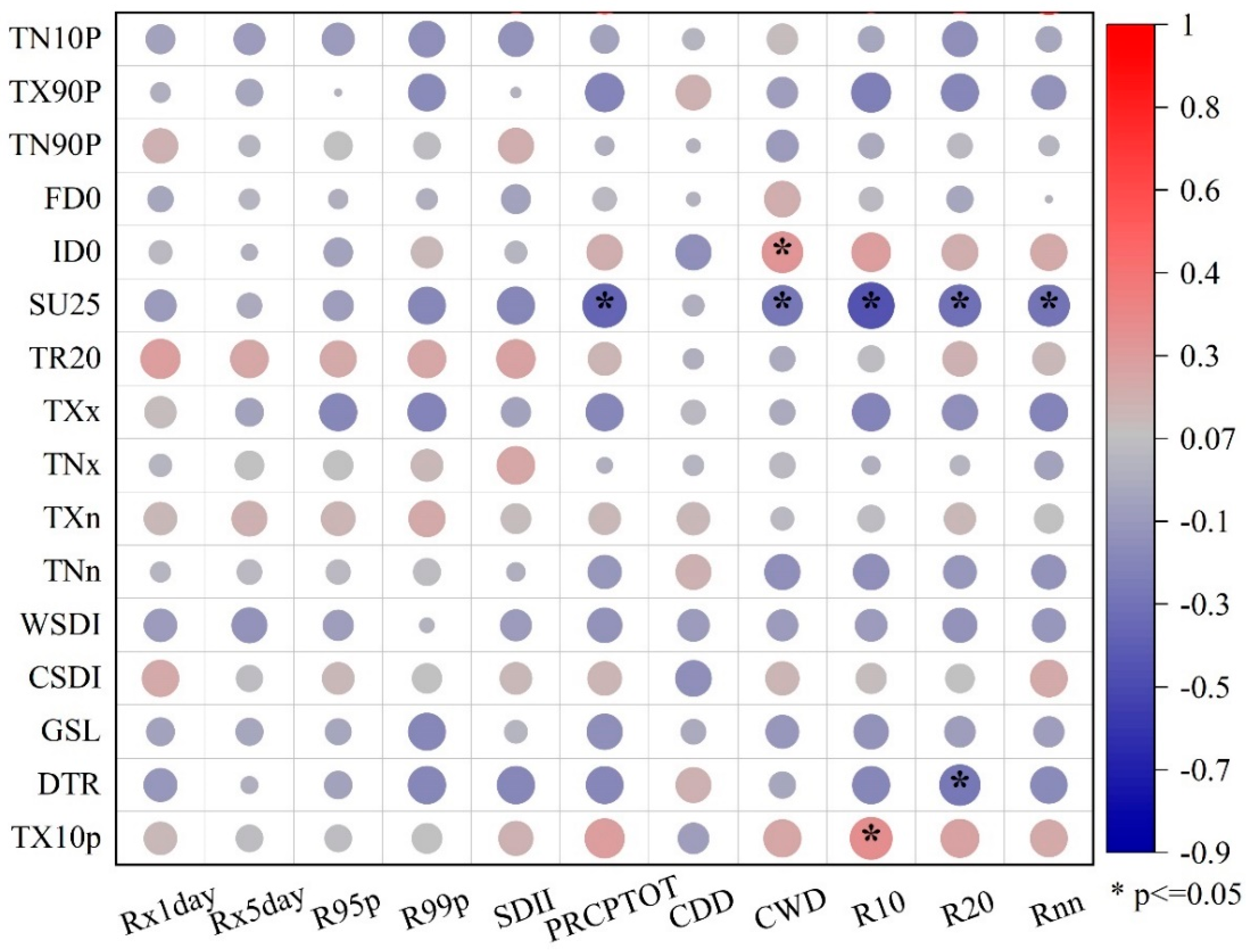
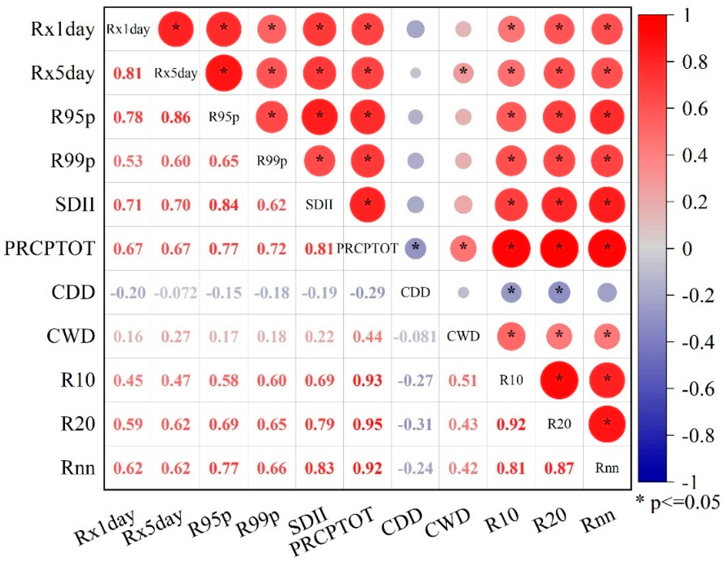
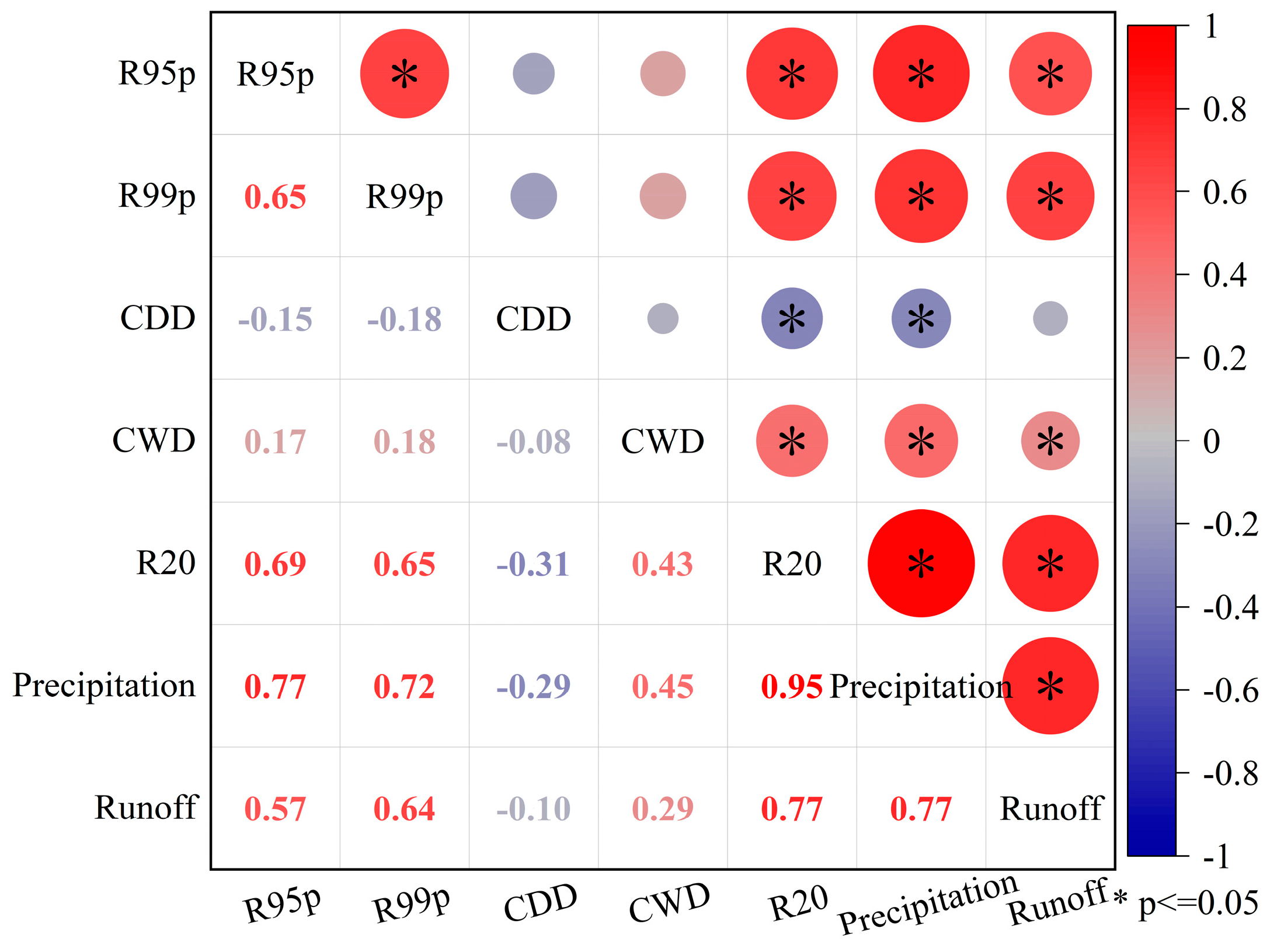
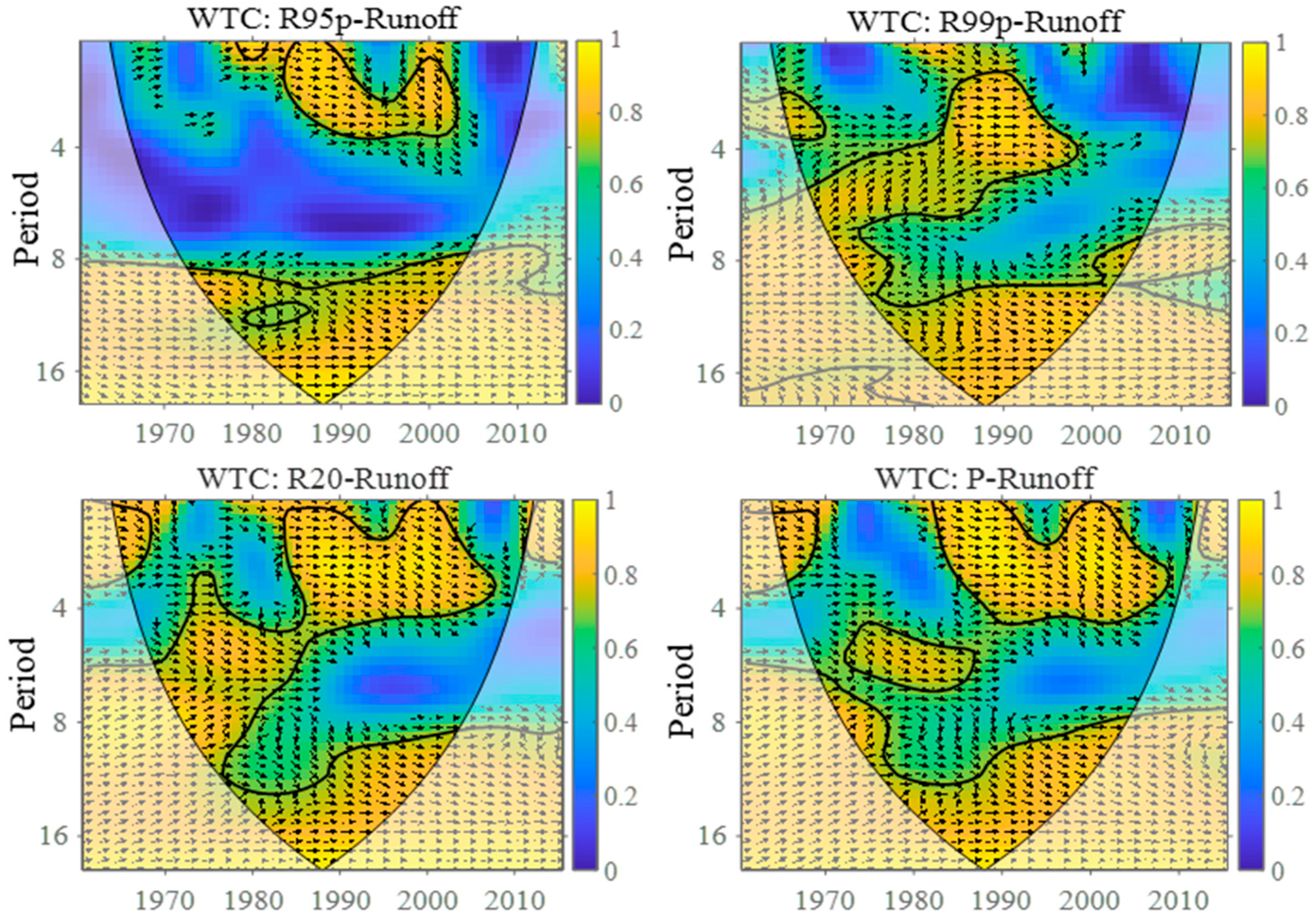
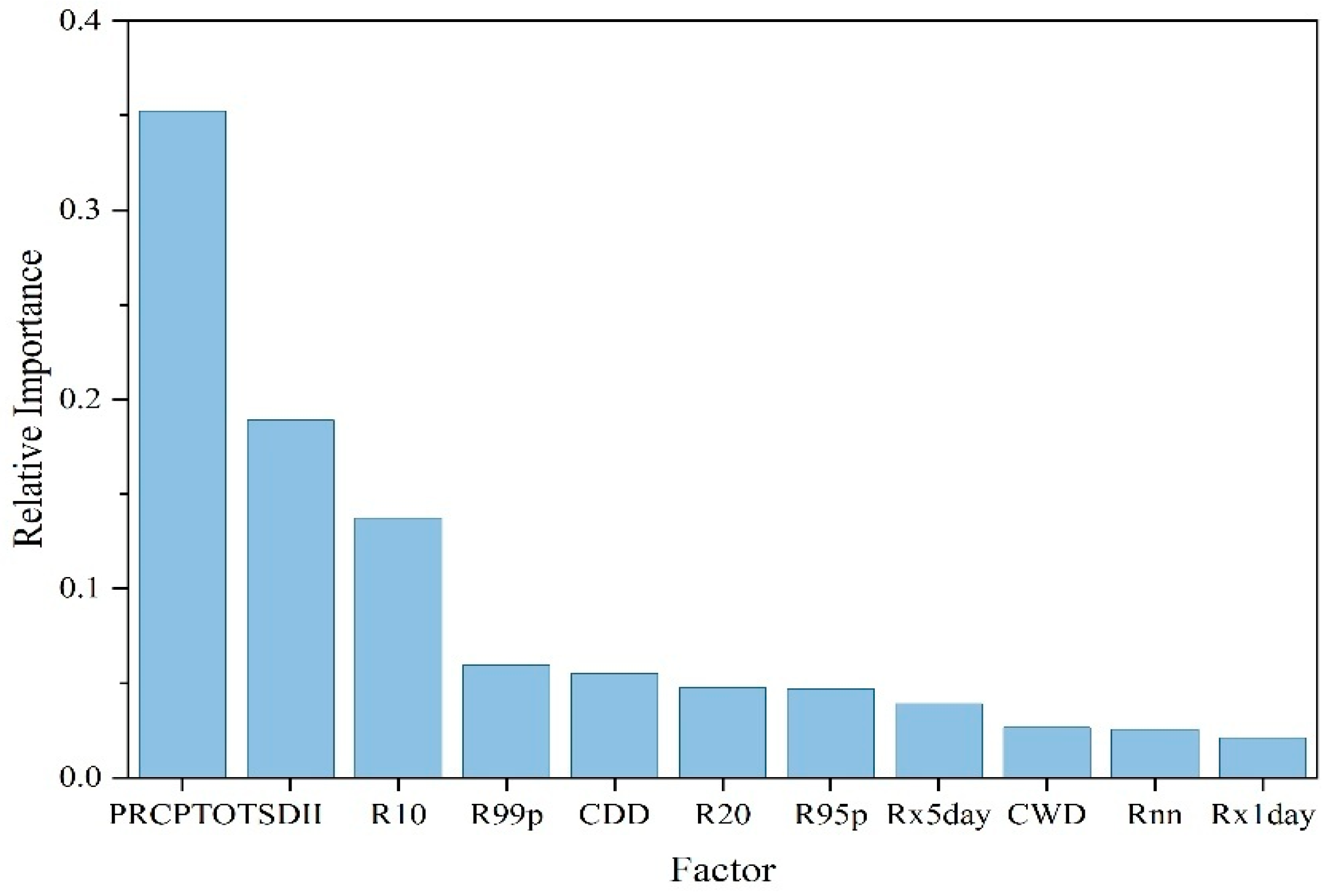
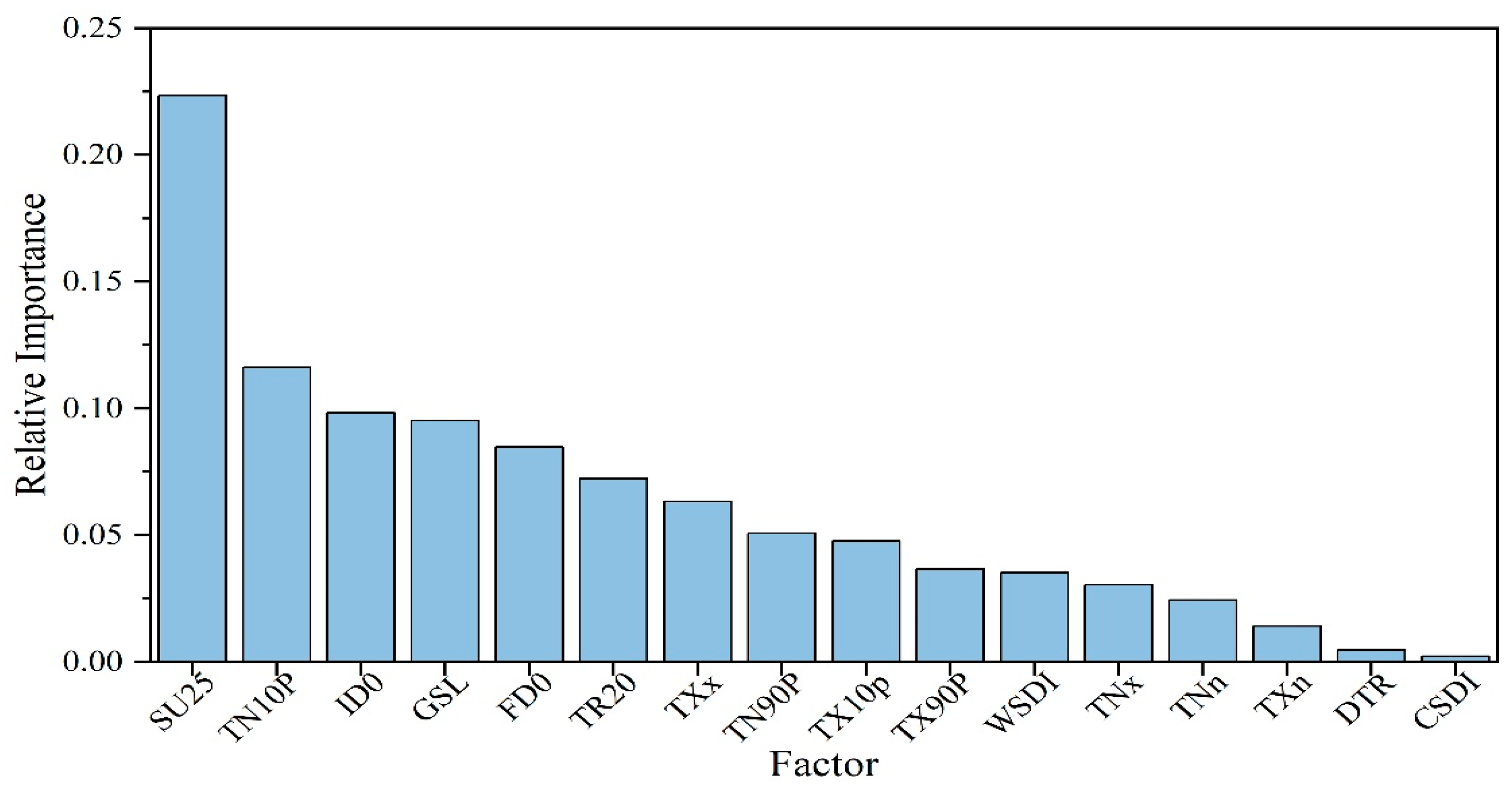
3.6.1. Identification of Runoff Change Drivers

Climate factors influencing runoff dynamics include precipitation, air temperature (daily maximum and minimum temperatures), evapotranspiration, solar radiation, relative humidity, atmospheric pressure, and wind speed. Precipitation serves as the primary source of runoff, while temperature and evapotranspiration modulate intermediate processes of precipitation-to-runoff conversion, interacting with other meteorological variables. Extreme precipitation indices and extreme temperature indices, derived from daily precipitation, maximum temperature, and minimum temperature data using the RClimDex model (Table A5 lists 16 extreme temperature and 11 extreme precipitation indices), exhibit minimal direct correlation. Among 176 calculated correlation coefficients, only eight showed statistical significance (Figure 10). Given this independence assumption between extreme precipitation and temperature indices, precipitation and temperature were selected as the dominant climate change factors for runoff attribution analysis.
(1)
Precipitation Factors
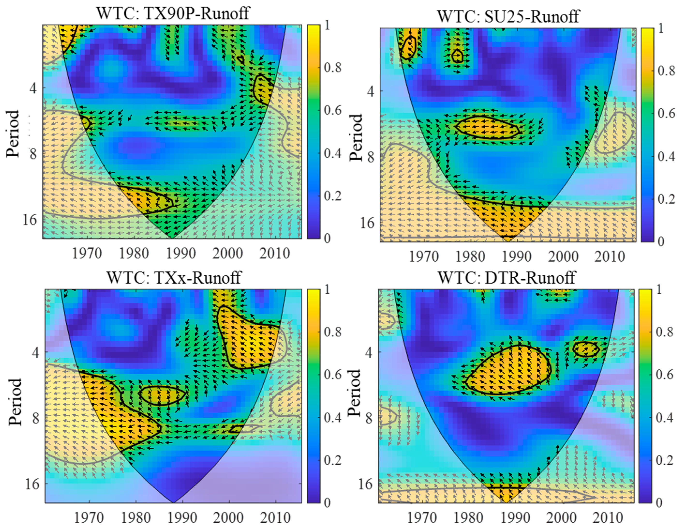
Correlation analysis of extreme precipitation indices is illustrated in Figure 11. Results demonstrate strong correlations (coefficients > 0.77) between runoff and indices including R95p, Rx1day, Rx5day, SDII, PRCPTOT, and Rnn (number of heavy precipitation days). R99p exhibits moderate correlations with other indices (0.53–0.72). CDD and CWD show weak correlations: CDD ranges from −0.31 to −0.07, and CWD from −0.08 to 0.51. Notably, R20, R10, and Rnn display exceptionally high inter-correlations (>0.87). Based on these findings, five extreme precipitation indices (R95p, R99p, CDD, CWD, R20) and annual precipitation at Daicunba Station were selected to assess precipitation impacts on runoff evolution.
As demonstrated in Figure 12, runoff exhibits correlations of 0.77, 0.77, 0.64, 0.57, and 0.29 with annual precipitation, R20, R99p, R95p, and CWD, respectively, ranked in descending order. In contrast, CDD shows a weak negative correlation with runoff (−0.10). These results confirm that runoff dynamics are closely linked to annual precipitation totals and intense rainfall events.
Wavelet coherence analysis was conducted between annual runoff and four precipitation indices with relatively strong correlations: R95p, R99p, R20, and annual precipitation (Figure 13). A higher wavelet coherence coefficient indicates stronger correlation strength between variables. Phase relationships are denoted as follows: “→”: In-phase oscillation (positive correlation); “←”: Anti-phase oscillation (negative correlation); “↑”: Runoff leads precipitation indices by a 90° phase shift; “↓”: Runoff lags precipitation indices by a 90° phase shift. The results (Figure 6) demonstrate strong correlations between all four precipitation indices and runoff. Specifically, annual precipitation, R20, R99p, and R95p exhibit progressively weakening correlation strengths with runoff, consistent with Pearson correlation analysis. On longer timescales (>10 years), all precipitation indices show persistent and highly correlated relationships with runoff across the entire study period. In contrast, short-term correlations (interannual scales) lack temporal continuity but display heightened coherence during 1990–2000. Nearly all precipitation indices exhibit positive phase relationships with runoff, with runoff showing a slight lag relative to precipitation drivers.
The relative importance ranking of 11 precipitation characteristics to runoff (Figure 14) reveals that annual precipitation dominates as the most influential factor, followed by SDII and R10. In contrast, Rx1day exhibits the lowest relative importance.
(2)
Temperature Factors
Compared to inter-precipitation index correlations, temperature indices exhibit weaker mutual associations. As shown in Figure 15, TN10p demonstrates moderate correlations (absolute coefficients ≥ 0.54) with TX10p, TN90p, FD0, TR20, TNn, CSDI, GSL, and DTR. TX90p correlates notably (absolute coefficients ≥ 0.55) with TN90p, SU25, and WSDI. ID0 shows stronger correlations (≥0.61) with TX0p, TXn, and TNn. TNx only weakly correlates with TN90p (absolute coefficient 0.53), while TXx exhibits minimal correlations (absolute coefficients < 0.4) with other indices. Consequently, TN10p, TX90p, ID0, TXx, and TNx are identified as relatively independent temperature drivers. Most temperature indices show weak correlations with runoff, with only TX90p, SU25, and TXx passing statistical significance tests. This suggests that high-temperature extremes exert greater hydrological influence than low-temperature events, likely due to their amplified effects on evapotranspiration and subsequent suppression of precipitation-to-runoff conversion efficiency.
Wavelet coherence analysis was performed between annual runoff and temperature indices with relatively strong correlations: TX90p, SU25, TXx, and DTR (Figure 16). Results demonstrate alignment with Pearson correlation outcomes, wherein SU25 exhibits the closest linkage to runoff. On short-term scales, TXx shows significant coherence with runoff post-2000. Long-term scales reveal persistent correlations between SU25, DTR, and runoff across the entire temporal domain. Notably, TXx and SU25 display intensified phase synchronization during 1995–2010, while DTR–runoff interactions exhibit intermittent coherence modulated by decadal climatic oscillations.
The relative importance ranking of 16 extreme temperature indices to runoff (Figure 17) identifies SU25 as the most critical factor, followed by TN10p, ID0, GSL, and FD0. This hierarchy suggests that cold-temperature-related indices exhibit higher relative importance within the Dawen River Basin.

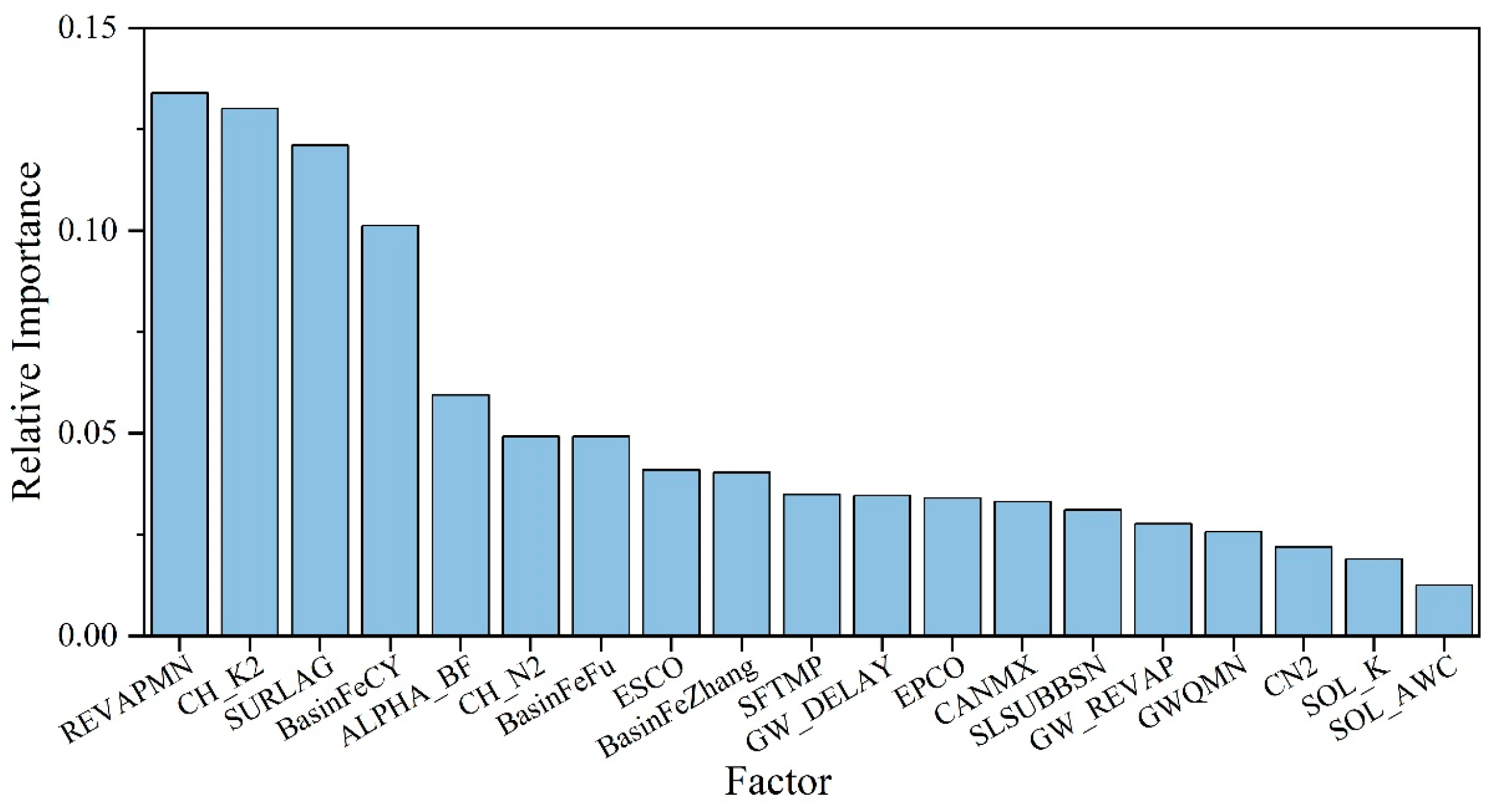
3.6.2. Basin Characteristic Factors

In methodologies for disentangling climate change and human activity impacts, three Budyko framework-based elasticity coefficient approaches (Fu, Zhang, and Choudhury–Yang equations) incorporate basin-specific parameters termed BasinFeFu, BasinFeZhang, and BasinFeCY. The SWAT model employs 16 parameters to characterize basin attributes: SOL_AWC (soil available water capacity), SOL_K (saturated hydraulic conductivity), CN2 (SCS runoff curve number), ALPHA_BF (baseflow alpha factor), GW_DELAY (groundwater delay time), GWQMN (threshold water level for baseflow), REVAPMN (threshold depth for re-evaporation from shallow aquifer), GW_REVAP (groundwater revap coefficient), CH_K2 (effective hydraulic conductivity), CH_N2 (Manning’s roughness coefficient), SLSUBBSN (average slope length), EPCO (plant uptake compensation factor), ESCO (soil evaporation compensation factor), CANMX (maximum canopy storage), SURLAG (surface runoff lag time), and SFTMP (snowfall temperature).
Correlation analysis of these 19 basin characteristic parameters (Figure 18) revealed strong interdependencies: CN2 correlated significantly (|r| ≥ 0.73) with SOL_K, GW_REVAP, CH_K2, CH_N2, CANMX, SURLAG, and SFTMP; ALPHA_BF showed high correlations (r ≥ 0.85) with EPCO and ESCO; GWQMN exhibited robust linkages (|r| ≥ 0.74) with SOL_AWC, GW_DELAY, and SLSUBBSN; and BasinFeZhang demonstrated near-perfect correlations (r ≥ 0.89) with BasinFeFu, REVAPMN, and BasinFeCY. Consequently, four relatively independent parameters—CN2, ALPHA_BF, GWQMN, and BasinFeZhang—were selected.
Random forest-based importance ranking (Figure 19) identified REVAPMN, CH_K2, SURLAG, BasinFeCY, ALPHA_BF, and CH_N2 as critical drivers of runoff changes, highlighting the dominance of groundwater–channel interactions and anthropogenic basin modifications in hydrological dynamics.

3.6.3. Adaptability Assessment of Runoff Attribution Methods

The complexity of basin-scale runoff dynamics stems from their multifaceted drivers, which are categorized into driving factors (climate elements and human activities) and basin characteristic factors (reflecting underlying surface attributes). In this study, runoff driving factors include 11 extreme precipitation indices (e.g., R95p, R99p), 16 extreme temperature indices (e.g., TN10p, TX90p), water abstraction in the Dawen River Basin (WatUseDai), and land use categories (cropland, forest, pasture, urban, bare land). Basin characteristic factors encompass SWAT model calibration parameters (e.g., CN2, ALPHA_BF) and Budyko framework-derived parameters (BasinFeFu, BasinFeZhang, BasinFeCY).
Random forest-based importance ranking of these factors reveals three key insights (Figure 20): (1) Annual precipitation (PRCPTOT) overwhelmingly dominates runoff variability, validating the use of the Precipitation–Runoff Double Mass Curve—a traditional statistical method relying solely on precipitation and runoff time series—to quantify contributions of climate change and human activities to runoff changes. During periods with near-normal precipitation and water abstraction, double mass curve results align closely with SWAT model outputs, offering a simplified yet reliable approach when human activity factors rank lower in importance. (2) Water abstraction ranks third in importance, exhibiting spatiotemporal heterogeneity across sub-basins. During dry periods (e.g., 2001–2010), intensified abstraction altered runoff directionality (augmentation or reduction), rendering non-parametric elasticity methods or double mass curve less reliable, necessitating parametric elasticity coefficient methods or hydrological modeling to capture nonlinear interactions. (3) Secondary drivers include ID0, R95p, R99p, TNx, TN10p, and CDD, highlighting the dual influence of precipitation extremes and thermal dynamics. BasinFeZhang, ranking ninth, underscores the integrative role of underlying surface properties, while land use types and human-modified parameters exhibit lower importance. This dichotomy illustrates that single climate change factors can directly alter runoff, whereas cumulative basin-scale adjustments are required to manifest hydrological impacts. Post-exclusion of precipitation/temperature factors, water abstraction and basin characteristics emerge as dominant residual drivers.
For the Dawen River Basin, the prominence of water abstraction (rank 3) and BasinFeZhang (rank 9) necessitates hydrological modeling (SWAT) for robust attribution. In other basins, preliminary analysis of local drivers and characteristics—combined with data availability—should guide method selection, prioritizing approaches aligned with the highest-ranked factors (e.g., elasticity methods for precipitation-dominated systems, SWAT for groundwater–channel interaction systems).
For the Dawen River Basin, the high rankings of water abstraction (rank 3) and basin characteristic parameter BasinFeZhang (rank 9) indicate that hydrological modeling (SWAT) is the most suitable method for runoff attribution analysis. In other basins, preliminary assessments of local runoff driving factors and basin characteristic factors should be conducted. Method selection must integrate parameter importance ranking results with data availability, prioritizing approaches that align with dominant drivers.

4. Conclusions

This study conducted relative importance analysis on precipitation factors, temperature factors, and basin characteristic factors within runoff drivers, establishing a methodological adaptability framework for runoff change attribution. Using the Dawen River Basin as a case study, three approaches—Precipitation–Runoff Double Mass Curve, non-parametric/parametric elasticity coefficient methods, and the SWAT hydrological model—were employed to quantify contributions of climate change and human activities to runoff changes. First, climate change and human activities were broadly separated, followed by SWAT-based disaggregation of specific human activities (e.g., land use change, reservoir operation, water abstraction). Key findings include the following: ① Multi-method consensus on human activities dominance: All four methods identified human activities as the primary driver of runoff reduction (55–90% contribution). ② Quantitative separation of the effects of various human activities on runoff change: SWAT-based analysis revealed divergent impacts: consumptive water use consistently reduced runoff (primary contributor), and LUCC increased runoff in the Dawenkou and Daicunba reservoirs by 19–42%. Limited reservoir data (3 of 23 major reservoirs modeled) likely underestimated these impacts. ③ Methodological adaptability framework: In other basins, the selection of runoff-related parameters (i.e., runoff drivers and basin characteristic factors) should first be based on the accessibility of basin-specific data. The relative importance of these parameters is then evaluated via random forest ranking, with method selection guided by the ranking results. For preliminary identification of dominant runoff change drivers, elasticity coefficient methods are prioritized, with a choice between parametric and non-parametric approaches depending on data availability. In basins with extremely limited data, the Precipitation–Runoff Double Mass Curve serves as a viable alternative. Where detailed understanding of runoff change factors—particularly the contribution of various human activitiesis required, priority should be given to hydrological modeling, though its practical implementation entails greater operational complexity.

Author Contributions

Conceptualization, C.H., Z.Y. and Y.Y.; Data curation, X.Y. and Y.Y.; Formal analysis, H.M. and Y.Y.; Investigation, H.M., Y.Y. and J.Z.; Methodology, C.H., Z.Y. and Y.Y.; Resources, X.Y. and J.Z.; Software, Chuan Huang, Z.Y., X.Y. and H.M.; Validation, Z.Y. and X.Y.; Visualization, C.H. and X.Y.; Writing—original draft, C.H.; Writing—review and editing, Z.Y. All authors have read and agreed to the published version of the manuscript.

Funding

This research was funded by the Shaanxi Provincial Department of Education service local special project, grant number 23JE003, the Shaanxi Province natural science basic research program, grant number 2024JC-YBQN-0274, Project “Simulation and Regulation of Water and Salt Process in the Irrigation Districts of Lower Yellow River Basin under the High-quality Development” supported by the National Natural Science Foundation of China, grant number U22A20555. This study was awarded funding from the Provincial College Students’ Innovation and Entrepreneurship Training Program.

Data Availability Statement

The original contributions presented in this study are included in the article. Further inquiries can be directed to the corresponding author.

Acknowledgments

We thank the anonymous reviewers for their constructive feedback.

Conflicts of Interest

Author Huan Ma was employed by the company Powerchina Northwest Engineering Corporation. The remaining authors declare that the research was conducted in the absence of any commercial or financial relationships that could be construed as a potential conflict of interest.

Appendix A

Table A1. Climate–human runoff attribution: Double Mass Curve analysis.
Sub-BasinPeriodObserved
Precipitation (mm)
Observed
Runoff (mm)
Reconstructed Runoff (mm) ζ C ζ H
MeanChangeMeanChange
LaiwuBaseline Period1961–1976748.66/293.98////
Change Periods1977–1990619.53−129.13174.17−119.81263.9225%75%
1991–2000675.79−72.87180.64−113.34266.3324%76%
2001–2010728.47−20.19226.53−67.45287.0910%90%
2011–2019658.72−89.94153.36−140.62259.6024%76%
1977–2019666.15−82.51183.49−110.49268.9623%77%
BeiwangBaseline Period1961–1976702.49/248.39////
Change Periods1977–1990586.88−115.61119.21−129.19207.6932%68%
1991–2000640.77−61.72142.57−105.83221.1326%74%
2001–2010676.67−25.82208.96−39.44233.5238%62%
2011–2019663.73−38.76130.39−118.00229.0516%84%
1977–2019643.79−58.70153.28−95.11227.3222%78%
DawenkouBaseline Period1961–1976722.15/225.80////
Change Periods1977–1990609.75−112.41114.50−111.30189.3133%67%
1991–2000647.56−74.59145.82−79.99187.6648%52%
2001–2010703.69−18.46212.94−12.86203.93170%−70%
2011–2019659.72−62.44129.29−96.51191.1936%64%
1977–2019651.94−70.21147.65−78.16190.7745%55%
DaicunbaBaseline Period1961–1976724.97/174.44////
Change Periods1977–1990616.27−108.7066.07−108.38151.0822%78%
1991–2000653.64−71.3484.95−89.49145.1733%67%
2001–2010722.18−2.80141.71−32.73160.4043%57%
2011–2019642.42−82.5567.44−107.00142.6830%70%
1977–2019655.06−69.9188.34−86.10150.1228%72%
Table A2. Climate–human runoff attribution: Elasticity Coefficient Method.
MethodSub-BasinPeriodParameterɛPɛE0∆RP/mm∆RE0/mm∆RC/mm∆RH/mm∆R ζ C ζ H
SchreiberLaiwu1977–1990/2.80−1.80−142.0322.95−119.08−0.73−119.8199%1%
1991–2000/2.64−1.64−75.4125.19−50.22−63.12−113.3444%56%
2001–2010/2.51−1.51−19.8726.396.53−73.98−67.45−10%110%
2011–2019/2.72−1.72−96.0514.52−81.53−59.09−140.6258%42%
1977–2019/2.67−1.67−86.5122.67−63.84−46.65−110.4958%42%
Beiwang1977–1990/2.90−1.90−110.5424.31−86.23−43.98−130.2166%34%
1991–2000/2.81−1.81−74.3422.81−51.53−72.00−123.5342%58%
2001–2010/2.71−1.71−35.2123.97−11.25−45.89−57.1420%80%
2011–2019/2.74−1.74−48.9224.17−24.75−110.95−135.7018%82%
1977–2019/2.80−1.80−70.8323.85−46.98−65.83−112.8142%58%
Dawenkou1977–1990/2.86−1.86−100.6917.76−82.93−28.37−111.3075%25%
1991–2000/2.75−1.75−64.2616.96−47.30−32.69−79.9959%41%
2001–2010/2.60−1.60−15.0318.093.06−15.92−12.86−24%124%
2011–2019/2.73−1.73−53.3414.60−38.75−57.76−96.5140%60%
1977–2019/2.75−1.75−61.2116.99−44.22−33.81−78.0357%43%
Daicunba1977–1990/2.83−1.83−75.6015.46−60.14−51.90−112.0554%46%
1991–2000/2.70−1.70−47.3518.50−28.85−64.31−93.1631%69%
2001–2010/2.54−1.54−1.7417.4715.73−52.13−36.40−43%143%
2011–2019/2.73−1.73−55.3019.53−35.77−74.90−110.6732%68%
1977–2019/2.70−1.70−46.4417.53−28.90−60.87−89.7732%68%
Ol’dekopLaiwu1977–1990/2.78−1.78−141.0122.69−118.32−1.49−119.8199%1%
1991–2000/2.74−1.74−78.4226.81−51.61−61.73−113.3446%54%
2001–2010/2.70−1.70−21.4229.828.41−75.86−67.45−12%112%
2011–2019/2.76−1.76−97.5614.88−82.68−57.95−140.6259%41%
1977–2019/2.75−1.75−89.0923.75−65.34−45.15−110.4959%41%
Beiwang1977–1990/2.80−1.80−106.6823.01−83.66−46.54−130.2164%36%
1991–2000/2.78−1.78−73.5922.45−51.14−72.39−123.5341%59%
2001–2010/2.76−1.76−35.9124.71−11.19−45.95−57.1420%80%
2011–2019/2.77−1.77−49.4024.54−24.86−110.84−135.7018%82%
1977–2019/2.78−1.78−70.3723.61−46.76−66.05−112.8141%59%
Dawenkou1977–1990/2.79−1.79−98.2117.09−81.12−30.18−111.3073%27%
1991–2000/2.77−1.77−64.6217.11−47.52−32.47−79.9959%41%
2001–2010/2.73−1.73−15.7719.543.77−16.63−12.86−29%129%
2011–2019/2.77−1.77−53.9914.88−39.11−57.40−96.5141%59%
1977–2019/2.77−1.77−61.7317.22−44.51−33.52−78.0357%43%
Daicunba1977–1990/2.79−1.79−74.4415.09−59.34−52.70−112.0553%47%
1991–2000/2.76−1.76−48.3419.11−29.23−63.93−93.1631%69%
2001–2010/2.71−1.71−1.8619.4717.61−54.00−36.40−48%148%
2011–2019/2.76−1.76−56.0619.96−36.10−74.57−110.6733%67%
1977–2019/2.76−1.76−47.3818.10−29.28−60.49−89.7733%67%
BudykoLaiwu1977–1990/2.81−1.81−142.3223.02−119.30−0.52−119.81100%0%
1991–2000/2.68−1.68−76.8325.95−50.88−62.47−113.3445%55%
2001–2010/2.59−1.59−20.5127.817.30−74.76−67.45−11%111%
2011–2019/2.75−1.75−97.0314.76−82.27−58.35−140.6259%41%
1977–2019/2.71−1.71−87.8223.22−64.60−45.89−110.4958%42%
Beiwang1977–1990/2.88−1.88−109.6524.01−85.64−44.57−130.2166%34%
1991–2000/2.81−1.81−74.4222.85−51.57−71.96−123.5342%58%
2001–2010/2.74−1.74−35.6224.41−11.21−45.92−57.1420%80%
2011–2019/2.76−1.76−49.3224.47−24.84−110.86−135.7018%82%
1977–2019/2.80−1.80−70.9923.94−47.06−65.76−112.8142%58%
Dawenkou1977–1990/2.85−1.85−100.2617.65−82.61−28.69−111.3074%26%
1991–2000/2.77−1.77−64.6817.13−47.55−32.44−79.9959%41%
2001–2010/2.66−1.66−15.3618.743.38−16.24−12.86−26%126%
2011–2019/2.76−1.76−53.8214.80−39.02−57.49−96.5140%60%
1977–2019/2.77−1.77−61.6817.20−44.48−33.55−78.0357%43%
Daicunba1977–1990/2.83−1.83−75.5315.44−60.09−51.95−112.0554%46%
1991–2000/2.73−1.73−47.9218.85−29.07−64.09−93.1631%69%
2001–2010/2.61−1.61−1.7918.3116.52−52.92−36.40−45%145%
2011–2019/2.75−1.75−55.8219.83−36.00−74.67−110.6733%67%
1977–2019/2.74−1.74−46.9917.86−29.12−60.65−89.7732%68%
Turc–PikeLaiwu1977–1990/2.64−1.64−133.7920.88−112.91−6.90−119.8194%6%
1991–2000/2.58−1.58−73.8624.35−49.50−63.84−113.3444%56%
2001–2010/2.53−1.53−20.0426.776.73−74.19−67.45−10%110%
2011–2019/2.61−1.61−92.2413.61−78.63−61.99−140.6256%44%
1977–2019/2.59−1.59−84.0421.64−62.41−48.08−110.4956%44%
Beiwang1977–1990/2.67−1.67−101.6221.32−80.31−49.90−130.2162%38%
1991–2000/2.64−1.64−69.8520.67−49.18−74.35−123.5340%60%
2001–2010/2.61−1.61−33.9322.58−11.35−45.79−57.1420%80%
2011–2019/2.62−1.62−46.7522.48−24.27−111.43−135.7018%82%
1977–2019/2.64−1.64−66.7621.72−45.04−67.77−112.8140%60%
Dawenkou1977–1990/2.66−1.66−93.4215.79−77.63−33.67−111.3070%30%
1991–2000/2.62−1.62−61.2015.69−45.51−34.48−79.9957%43%
2001–2010/2.57−1.57−14.8317.702.87−15.73−12.86−22%122%
2011–2019/2.62−1.62−51.0813.62−37.46−59.05−96.5139%61%
1977–2019/2.62−1.62−58.4315.78−42.65−35.38−78.0355%45%
Daicunba1977–1990/2.65−1.65−70.7113.92−56.80−55.25−112.0551%49%
1991–2000/2.61−1.61−45.6617.45−28.21−64.95−93.1630%70%
2001–2010/2.54−1.54−1.7517.5315.78−52.18−36.40−43%143%
2011–2019/2.61−1.61−53.0218.26−34.76−75.91−110.6731%69%
1977–2019/2.61−1.61−44.7616.53−28.23−61.54−89.7731%69%
FuLaiwu1977–19901.931.80−0.80−91.5010.25−81.25−38.56−119.8168%32%
1991–20002.051.90−0.90−54.4013.88−40.52−72.82−113.3436%64%
2001–20101.971.80−0.80−14.3114.10−0.20−67.25−67.450%100%
2011–20192.142.00−1.00−70.578.43−62.14−78.48−140.6244%56%
1977–20192.001.86−0.86−60.3111.69−48.61−61.87−110.4944%56%
Beiwang1977–19902.091.97−0.97−75.0612.41−62.65−67.55−130.2148%52%
1991–20002.142.00−1.00−53.0012.65−40.35−83.18−123.5333%67%
2001–20101.881.75−0.75−22.7810.55−12.24−44.90−57.1421%79%
2011–20192.302.15−1.15−38.4216.00−22.42−113.28−135.7017%83%
1977–20192.081.95−0.95−49.3212.58−36.74−76.07−112.8133%67%
Dawenkou1977–19902.272.14−1.14−75.1510.84−64.31−46.99−111.3058%42%
1991–20002.162.02−1.02−47.019.81−37.20−42.79−79.9947%53%
2001–20101.941.80−0.80−10.389.00−1.38−11.48−12.8611%89%
2011–20192.312.16−1.16−42.139.76−32.38−64.14−96.5134%66%
1977–20192.152.01−1.01−44.859.85−35.00−43.03−78.0345%55%
Daicunba1977–19902.862.72−1.72−72.5914.51−58.08−53.97−112.0552%48%
1991–20002.792.61−1.61−45.7817.52−28.26−64.90−93.1630%70%
2001–20102.472.27−1.27−1.5614.4512.89−49.29−36.40−35%135%
2011–20193.002.83−1.83−57.4820.75−36.73−73.94−110.6733%67%
1977–20192.742.57−1.57−44.1216.15−27.98−61.80−89.7731%69%
Zhang et al.Laiwu1977–19900.231.93−0.93−97.9311.87−86.07−33.75−119.8172%28%
1991–20000.412.03−1.03−58.0415.84−42.20−71.14−113.3437%63%
2001–20100.311.91−0.91−15.1415.950.81−68.26−67.45−1%101%
2011–20190.532.13−1.13−75.379.58−65.79−74.83−140.6247%53%
1977–20190.341.99−0.99−64.4513.43−51.02−59.47−110.4946%54%
Beiwang1977–19900.442.13−1.13−81.1114.43−66.67−63.54−130.2151%49%
1991–20000.512.15−1.15−56.8914.50−42.39−81.14−123.5334%66%
2001–20100.181.86−0.86−24.1512.02−12.13−45.01−57.1421%79%
2011–20190.782.27−1.27−40.4417.57−22.87−112.83−135.7017%83%
1977–20190.432.10−1.10−53.0414.53−38.51−74.30−112.8134%66%
Dawenkou1977–19900.712.27−1.27−79.9312.14−67.79−43.51−111.3061%39%
1991–20000.552.15−1.15−50.2511.15−39.10−40.89−79.9949%51%
2001–20100.271.91−0.91−11.0310.27−0.76−12.10−12.866%94%
2011–20190.792.27−1.27−44.2910.69−33.60−62.91−96.5135%65%
1977–20190.542.15−1.15−47.9311.19−36.74−41.29−78.0347%53%
Daicunba1977–19901.942.59−1.59−69.1513.42−55.73−56.32−112.0550%50%
1991–20001.722.52−1.52−44.1516.51−27.64−65.52−93.1630%70%
2001–20101.092.31−1.31−1.5814.8613.28−49.68−36.40−36%136%
2011–20192.282.61−1.61−52.9118.20−34.71−75.96−110.6731%69%
1977–20191.622.50−1.50−42.9515.44−27.50−62.27−89.7731%69%
Choudhury–YangLaiwu1977–19901.211.84−0.84−93.3910.73−82.66−37.15−119.8169%31%
1991–20001.341.93−0.93−55.3514.39−40.96−72.38−113.3436%64%
2001–20101.261.83−0.83−14.5014.530.03−67.48−67.450%100%
2011–20191.432.04−1.04−72.028.78−63.24−77.38−140.6245%55%
1977–20191.291.90−0.90−61.4012.15−49.25−61.24−110.4945%55%
Beiwang1977–19901.372.02−1.02−76.9213.03−63.89−66.32−130.2149%51%
1991–20001.422.05−1.05−54.2113.23−40.99−82.54−123.5333%67%
2001–20101.161.78−0.78−23.1910.99−12.20−44.93−57.1421%79%
2011–20191.592.20−1.20−39.2716.66−22.61−113.09−135.7017%83%
1977–20191.361.99−0.99−50.4013.15−37.26−75.56−112.8133%67%
Dawenkou1977–19901.552.19−1.19−77.0511.36−65.69−45.61−111.3059%41%
1991–20001.442.06−1.06−48.0210.23−37.79−42.19−79.9947%53%
2001–20101.231.83−0.83−10.559.33−1.22−11.64−12.869%91%
2011–20191.602.21−1.21−43.0610.16−32.90−63.61−96.5134%66%
1977–20191.442.05−1.05−45.8010.26−35.54−42.49−78.0346%54%
Daicunba1977–19902.142.79−1.79−74.5915.14−59.45−52.60−112.0553%47%
1991–20002.072.67−1.67−46.8618.19−28.67−64.49−93.1631%69%
2001–20101.762.31−1.31−1.5914.8913.31−49.71−36.40−37%137%
2011–20192.282.91−1.91−58.9221.55−37.37−73.30−110.6734%66%
1977–20192.022.63−1.63−45.1616.77−28.39−61.38−89.7732%68%
Table A3. Quantitative separation of climate change and human activities results by the SWAT model.
Sub-BasinScenario SetupObserved Runoff (mm)Simulated Runoff (mm)Climate ChangeHuman Activities
MeanChangeChange (mm)ContributionChange (mm)Contribution
Laiwu1961–1976 S1293.13/310.49////
1977–2019 S2183.49−127.00272.20−38.2930%−88.7170%
1977–1990 S3174.17−136.32235.19−75.3055%−61.0245%
1991–2000 S4180.64−129.85280.87−29.6223%−100.2377%
2001–2010 S5226.53−83.96313.773.28−4%−87.24104%
2011–2019 S6153.36−157.13273.96−36.5323%−120.6077%
Beiwang1961–1976 S1356.77/394.05////
1977–2019 S2217.15−176.90356.68−37.3721%−139.5279%
1977–1990 S3192.50−201.54317.56−76.4938%−125.0562%
1991–2000 S4201.97−192.08357.70−36.3419%−155.7481%
2001–2010 S5296.02−98.03389.24−4.815%−93.2295%
2011–2019 S6184.72−209.32380.20−13.857%−195.4893%
Dawenkou1961–1976 S1304.30/356.16////
1977–2019 S2209.35−146.81320.44−35.7124%−111.1076%
1977–1990 S3162.21−193.95268.54−87.6145%−106.3355%
1991–2000 S4206.58−149.58318.42−37.7325%−111.8575%
2001–2010 S5301.67−54.49381.1424.99−46%−79.47146%
2011–2019 S6183.16−172.99335.97−20.1812%−152.8188%
Daicunba1961–1976 S1235.74/284.53////
1977–2019 S2125.15−159.39255.46−29.0718%−130.3182%
1977–1990 S393.59−190.94205.16−79.3842%−111.5658%
1991–2000 S4120.35−164.18257.50−27.0316%−137.1684%
2001–2010 S5200.76−83.77322.2237.69−45%−121.46145%
2011–2019 S695.54−188.99257.26−27.2714%−161.7286%
Table A4. Quantitative separation of various human activities using the SWAT model.
Sub-BasinScenario SetupSimulated Values (mm)Contribution of Human Activities: Magnitudes and RatesClimate Change (mm)
Human ActivitiesWater Withdrawal and UseReservoir OperationLUCCOther Factors
(mm)(%)(mm)(%)(mm)(%)(mm)(%)(mm)(%)(mm)(%)
LaiwuBaseline model A1121.78−61.0245%−70.5452%0.000%66.75−49%−57.2342%−75.3055%
A1,1192.32
A1,2192.32
A1,3125.57
Baseline model A2177.32−100.2377%−116.5090%0.000%102.83−79%−86.5667%−29.6223%
A2,1293.83
A2,2293.83
A2,3191.00
Baseline model A3222.84−87.24104%−197.71235%0.000%162.49−194%−52.0262%3.28-4%
A3,1420.55
A3,2420.55
A3,3258.06
Baseline model A4113.20−120.6077%−78.9050%0.000%25.46−16%−67.1643%−36.5323%
A4,1192.10
A4,2192.10
A4,3166.64
BeiwangBaseline model A1115.44−125.0562%−140.6370%0.000%146.54−73%−130.9665%−76.4938%
A1,1256.07
A1,2256.07
A1,3109.53
Baseline model A2139.22−155.7481%−157.3482%0.280%136.89−71%−135.5671%−36.3419%
A2,1296.56
A2,2296.28
A2,3159.39
Baseline model A3207.60−93.2295%−226.54231%6.09−6%224.87−229%−97.64100%−4.815%
A3,1434.13
A3,2428.05
A3,3203.18
Baseline model A4107.65−195.4893%−97.7447%3.89−2%35.42−17%−137.0465%−13.857%
A4,1205.40
A4,2201.51
A4,3166.09
DawenkouBaseline model A1102.80−106.3355%−120.3862%3.45−2%104.03−54%−93.4448%−87.6145%
A1,1223.17
A1,2219.72
A1,3115.69
Baseline model A2128.77−111.8575%−121.8981%2.41−2%86.02−58%−78.4052%−37.7325%
A2,1250.66
A2,2248.24
A2,3162.22
Baseline model A3215.13−79.47146%−225.57414%22.94−42%180.76−332%−57.61106%24.99−46%
A3,1440.69
A3,2417.75
A3,3236.99
Baseline model A478.99−152.8188%−102.7559%4.77−3%−0.770%−54.0631%−20.1812%
A4,1181.74
A4,2176.97
A4,3177.74
DaicunbaBaseline model A172.08−111.5658%−117.4161%2.36−1%70.63−37%−67.1535%−79.3842%
A1,1189.49
A1,2187.12
A1,3116.49
Baseline model A2102.14−137.1684%−130.1979%1.66−1%61.02−37%−69.6542%−27.0316%
A2,1232.33
A2,2230.67
A2,3169.65
Baseline model A3163.12−121.46145%−228.24272%15.77−19%126.57−151%−35.5642%37.69−45%
A3,1391.36
A3,2375.59
A3,3249.02
Baseline model A441.27−161.7286%−113.1760%3.25−2%−15.788%−36.0219%−27.2714%
A4,1154.45
A4,2151.19
A4,3166.97
Table A5. Climate indicators from the Expert Team on Climate Change Detection and Indices (ETCCDMI).
IDIndicator NameDefinitionsUnits
TN10pCool nightsPercentage of days when TN < 10th percentileDays
TX10pCool daysPercentage of days when TX < 10th percentileDays
TN90pWarm nightsPercentage of days when TN > 90th percentileDays
TX90pWarm daysPercentage of days when TX > 90th percentileDays
FD0Frost daysAnnual count when TN (daily minimum) < 0 °CDays
SU25Summer daysAnnual count when TX (daily maximum) > 25 °CDays
ID0Ice daysAnnual count when TX (daily maximum) < 0 °CDays
TR20Tropical nightsAnnual count when TN (daily minimum) > 20 °CDays
TXxMax TmaxMonthly maximum value of daily maximum temp°C
TNxMax TminMonthly maximum value of daily minimum temp°C
TXnMin TmaxMonthly minimum value of daily maximum temp°C
TNnMin TminMonthly minimum value of daily minimum temp°C
WSDIWarm spell duration indicatorAnnual count of days with at least 6 consecutive days when TX > 90th percentileDays
CSDICold spell duration indicatorAnnual count of days with at least 6 consecutive days when TN < 10th percentileDays
DTRDiurnal temperature rangeMonthly mean difference between TX and TN°C
GSLGrowing season LengthAnnual (1 January to 31 December in NH, 1 July to 30 June in SH) count between first span of at least 6 days with TG > 5 °C and first span after 1 July (1 January in SH) of 6 days with TG < 5 °CDays
RX1dayMax 1-day precipitation amountMonthly maximum 1-day precipitationMm
Rx5dayMax 5-day precipitation amountMonthly maximum consecutive 5-day precipitationMm
R95pVery wet daysAnnual total PRCP when RR > 95th percentileMm
R99pExtremely wet daysAnnual total PRCP when RR > 99th percentilemm
SDIISimple daily intensity indexAnnual total precipitation divided by the number of wet days (defined as PRCP ≥ 1.0 mm) in the yearMm/day
PRCPTOTAnnual total wet-day precipitationAnnual total PRCP in wet days (RR ≥ 1 mm)mm
CDDConsecutive dry daysMaximum number of consecutive days with RR < 1 mmDays
CWDConsecutive wet daysMaximum number of consecutive days with RR ≥ 1 mmDays
R10Number of heavy precipitation daysAnnual count of days when PRCP ≥ 10 mmDays
R20Number of very heavy precipitation daysAnnual count of days when PRCP ≥ 20 mmDays
RnnNumber of days above nn mmAnnual count of days when PRCP ≥ nn mm, nn is a user-defined thresholdDays

Appendix B

Appendix B.1. The Construction of the SWAT Model

We constructed two SWAT models for the Dawen River Basin:
Natural period (1961–1976; S1 Model):
Input datasets included: 30 m DEM; soil database; 1980 LUCC; daily hydrometeorological records (precipitation, temperature, wind speed, solar radiation, relative humidity) from 1961–1976; monthly operational data of Huangqian (1964–1976) and Guangming (1965–1976) reservoirs; and water abstraction records (1961–1976). The S1 model underwent rigorous parameter calibration and validation.
Human activity period (1977–2019):
Four time-stratified SWAT configurations were developed:
A1 (1977–1990): 1990 LUCC; 1977–1990 daily hydrometeorology; operational records of Huangqian, Guangming (1977–1990), and Dongzhou (1979–1990) reservoirs; contemporaneous water abstraction data.
A2 (1991–2000): 2000 LUCC; 1991–2000 datasets with tri-reservoir (Huangqian, Guangming, Dongzhou) operations; contemporaneous water abstraction data.
A3 (2001–2010): 2010 LUCC data; 2001–2010 hydrometeorology, reservoir operations and water abstraction data.
A4 (2011–2019): 2018 LUCC; 2011–2019 hydrometeorology, reservoir operations and water abstraction data.

Appendix B.2. The Performance of the SWAT Model

Model performance was evaluated using three metrics: relative error (Re), coefficient of determination (R2), and Nash-Sutcliffe efficiency (NSE). Optimal simulation fidelity is achieved when values approach unity for R2 and NSE, while Re approaches zero. Established validation criteria require Re < 25%, R2 > 0.6, and NSE > 0.5—thresholds satisfied by all models in this study (Table A6). Monthly-scale comparisons between observed and simulated runoff are presented in Figure A1, Figure A2, Figure A3, Figure A4 and Figure A5.
Table A6. Model performance.
ModelPeriodLaiwuBeiwangDawenkouDaicunba
ReR2NSEReR2NSEReR2NSEReR2NSE
S11963–19762.3%0.840.840.4%0.840.848.9%0.790.797.8%0.830.81
1963–19708.5%0.870.8510.3%0.860.842.7%0.810.794.2%0.860.81
1971–197623.3%0.850.8219.0%0.890.8219.8%0.850.7815.4%0.870.82
A11979–199021.9%0.840.8010.1%0.790.788.4%0.770.7317.7%0.730.72
1979–198521.1%0.860.841.4%0.780.780.7%0.790.7816.9%0.720.71
1986–199022.9%0.860.7921.2%0.840.7817.1%0.770.7218.8%0.750.73
A21993–200015.8%0.770.7616.4%0.770.7620.7%0.810.7811.2%0.880.87
1993–199719.5%0.770.7619.7%0.780.7624.4%0.820.798.2%0.860.86
1998–20006.2%0.770.766.2%0.790.7510.6%0.780.7622.4%0.920.90
A32003–20106.1%0.750.7312.2%0.800.7910.5%0.850.840.5%0.840.84
2003–20072.0%0.760.7315.0%0.790.789.7%0.850.842.8%0.840.84
2008–201023.4%0.790.751.0%0.860.7112.9%0.830.826.1%0.820.81
A42013–201920.2%0.940.9215.7%0.960.9516.0%0.960.953.1%0.920.92
2013–201620.1%0.970.9121.8%0.980.9518.1%0.970.9515.8%0.930.92
2017–201920.3%0.930.935.7%0.970.9313.2%0.970.9615.0%0.970.91
Figure A1. Observed and simulated runoff values in all sub-basins (1961–1976).
Water 17 01538 g0a1
Figure A2. Observed and simulated runoff values in all sub-basins (1977–1990).
Water 17 01538 g0a2
Figure A3. Observed and simulated runoff values in all sub-basins (1991–2000).
Water 17 01538 g0a3
Figure A4. Observed and simulated runoff values in all sub-basins (2001–2010).
Water 17 01538 g0a4
Figure A5. Observed and simulated runoff values in all sub-basins (2010–2019).
Water 17 01538 g0a5

References

  1. Berg, P.; Moseley, C.; Haerter, J.O. Strong Increase in Convective Precipitation in Response to Higher Temperatures. Nat. Geosci. 2013, 6, 181–185. [Google Scholar] [CrossRef]
  2. IPCC. IPCC Climate Change 2014 Synthesis Report Summary Chapter for Policymakers; IPCC: Geneva, Switzerland, 2014. [Google Scholar]
  3. Brown, A.E.; Zhang, L.; McMahon, T.A.; Western, A.W.; Vertessy, R.A. A Review of Paired Catchment Studies for Determining Changes in Water Yield Resulting from Alterations in Vegetation. J. Hydrol. 2005, 310, 28–61. [Google Scholar] [CrossRef]
  4. Wang, S.; Zhang, Z.; McVicar, T.R.; Guo, J.; Tang, Y.; Yao, A. Isolating the Impacts of Climate Change and Land Use Change on Decadal Streamflow Variation: Assessing Three Complementary Approaches. J. Hydrol. 2013, 507, 63–74. [Google Scholar] [CrossRef]
  5. Prowse, T.D.; Beltaos, S.; Gardner, J.T.; Gibson, J.J.; Granger, R.J.; Leconte, R.; Peters, D.L.; Pietroniro, A.; Romolo, L.A.; Toth, B. Climate Change, Flow Regulation and Land-Use Effects on the Hydrology of the Peace-Athabasca-Slave System; Findings from the Northern Rivers Ecosystem Initiative. Environ. Monit. Assess. 2006, 113, 167–197. [Google Scholar] [CrossRef]
  6. Ma, Z.; Kang, S.; Zhang, L.; Tong, L.; Su, X. Analysis of Impacts of Climate Variability and Human Activity on Streamflow for a River Basin in Arid Region of Northwest China. J. Hydrol. 2008, 352, 239–249. [Google Scholar] [CrossRef]
  7. Zhang, X.; Zhang, L.; Zhao, J.; Rustomji, P.; Hairsine, P. Responses of Streamflow to Changes in Climate and Land Use/Cover in the Loess Plateau, China. Water Resour. Res. 2008, 44, 1–12. [Google Scholar] [CrossRef]
  8. Soldini, L.; Darvini, G. Extreme Rainfall Statistics in the Marche Region, Italy. Hydrol. Res. 2017, 48, 686–700. [Google Scholar] [CrossRef]
  9. Wang, S.; McVicar, T.R.; Zhang, Z.; Brunner, T.; Strauss, P. Globally Partitioning the Simultaneous Impacts of Climate-Induced and Human-Induced Changes on Catchment Streamflow: A Review and Meta-Analysis. J. Hydrol. 2020, 590, 125387. [Google Scholar] [CrossRef]
  10. Libertino, A.; Ganora, D.; Claps, P. Evidence for Increasing Rainfall Extremes Remains Elusive at Large Spatial Scales: The Case of Italy. Geophys. Res. Lett. 2019, 46, 7437–7446. [Google Scholar] [CrossRef]
  11. Zhang, X.; Zwiers, F.W.; Hegerl, G.C.; Lambert, F.H.; Gillett, N.P.; Solomon, S.; Stott, P.A.; Nozawa, T. Detection of Human Influence on Twentieth-Century Precipitation Trends. Nature 2007, 448, 461–465. [Google Scholar] [CrossRef]
  12. Xia, J.; Chen, J.; She, D. Impacts and Countermeasures of Extreme Drought in the Yangtze River Basin in 2022. J. Hydraul. Eng. 2022, 53, 1143–1153. [Google Scholar] [CrossRef]
  13. Chahine, M.T. The Hydrological Cycle and Its Influence on Climate. Nature 1992, 359, 373–380. [Google Scholar] [CrossRef]
  14. Du, H.; Xia, J.; Yan, Y.; Lu, Y.; Li, J. Spatiotemporal Variations of Extreme Precipitation in Wuling Mountain Area (China) and Their Connection to Potential Driving Factors. Sustainability 2022, 14, 8312. [Google Scholar] [CrossRef]
  15. Engel, T.; Fink, A.; Knippertz, P. Extreme Flooding in the West African Cities of Dakar and Ouagadougou—Atmospheric Dynamics and Implications for Flood Risk Assessments. EGUGA 2017, 19, 11983. [Google Scholar]
  16. Wallemacq, P.; House, R. Economic Losses, Poverty & Disasters: 1998–2017; UNDRR: Geneva, Switzerland, 2018. [Google Scholar] [CrossRef]
  17. Milly, P.C.D.; Dunne, K.A.; Vecchia, A.V. Global Pattern of Trends in Streamflow and Water Availability in a Changing Climate. Nature 2005, 438, 347–350. [Google Scholar] [CrossRef]
  18. Sharifi, A.; Mirchi, A.; Pirmoradian, R.; Mirabbasi, R.; Tourian, M.J.; Haghighi, A.T.; Madani, K. Battling Water Limits to Growth: Lessons from Water Trends in the Central Plateau of Iran. Environ. Manag. 2021, 68, 53–64. [Google Scholar] [CrossRef]
  19. Salmoral, G.; Willaarts, B.A.; Troch, P.A.; Garrido, A. Drivers Influencing Streamflow Changes in the Upper Turia Basin, Spain. Sci. Total Environ. 2015, 503–504, 258–268. [Google Scholar] [CrossRef]
  20. The Water Cycle|U.S. Geological Survey. Available online: https://www.usgs.gov/special-topics/water-science-school/science/water-cycle (accessed on 3 April 2025).
  21. Jaramillo, F.; Destouni, G. Local Flow Regulation and Irrigation Raise Global Human Water Consumption and Footprint. Science 2015, 350, 1248–1251. [Google Scholar] [CrossRef]
  22. Song, X.; Zhang, J.; Zhan, C.; Liu, C. Review for Impacts of Climate Change and Human Activities on Water Cycle. J. Hydraul. Eng. 2013, 44, 779–790. [Google Scholar] [CrossRef]
  23. Xia, J.; Zhan, C.; Zeng, S.; Zou, L.; She, D.; Zuo, Q. Theoretical Method and Practical Exploration of Yangtze River Simulator Construction. Shuili Xuebao/J. Hydraul. Eng. 2022, 53, 505–514. [Google Scholar] [CrossRef]
  24. Xia, J.; Zeng, S.; Du, C.; Zhan, H. Quantifying the Effects of Climate Change and Human Activities on Runoff in the Water Source Area of Beijing, China. Hydrol. Sci. J. 2014, 59, 1794–1807. [Google Scholar] [CrossRef]
  25. Ma, H.; Yang, D.; Tan, S.K.; Gao, B.; Hu, Q. Impact of Climate Variability and Human Activity on Streamflow Decrease in the Miyun Reservoir Catchment. J. Hydrol. 2010, 389, 317–324. [Google Scholar] [CrossRef]
  26. Zheng, H.; Zhang, L.; Zhu, R.; Liu, C.; Sato, Y.; Fukushima, Y. Responses of Streamflow to Climate and Land Surface Change in the Headwaters of the Yellow River Basin. Water Resour. Res. 2009, 45, 1–12. [Google Scholar] [CrossRef]
  27. Wang, W.; Shao, Q.; Yang, T.; Peng, S.; Xing, W.; Sun, F.; Luo, Y. Quantitative Assessment of the Impact of Climate Variability and Human Activities on Runoff Changes: A Case Study in Four Catchments of the Haihe River Basin, China. Hydrol. Process. 2013, 27, 1158–1174. [Google Scholar] [CrossRef]
  28. Poelmans, L.; Van Rompaey, A.; Ntegeka, V.; Willems, P. The Relative Impact of Climate Change and Urban Expansion on Peak Flows: A Case Study in Central Belgium. Hydrol. Process. 2011, 25, 2846–2858. [Google Scholar] [CrossRef]
  29. D’Agostino, D.R.; Trisorio, L.G.; Lamaddalena, N.; Ragab, R. Assessing the Results of Scenarios of Climate and Land Use Changes on the Hydrology of an Italian Catchment: Modelling Study. Hydrol. Process. 2010, 24, 2693–2704. [Google Scholar] [CrossRef]
  30. Saidi, H.; Dresti, C.; Manca, D.; Ciampittiello, M. Quantifying Impacts of Climate Variability and Human Activities on the Streamflow of an Alpine River. Environ. Earth Sci. 2018, 77, 690. [Google Scholar] [CrossRef]
  31. Arnell, N.W. Climate Change and Global Water Resources. Glob. Environ. Change 1999, 9, S31–S49. [Google Scholar] [CrossRef]
  32. Cheng, S.J.; Wang, R.Y. An Approach for Evaluating the Hydrological Effects of Urbanization and Its Application. Hydrol. Process. 2002, 16, 1403–1418. [Google Scholar] [CrossRef]
  33. Bronstert, A.; Niehoff, D.; Brger, G. Effects of Climate and Land-Use Change on Storm Runoff Generation: Present Knowledge and Modelling Capabilities. Hydrol. Process. 2002, 16, 509–529. [Google Scholar] [CrossRef]
  34. Foley, J.A.; DeFries, R.; Asner, G.P.; Barford, C.; Bonan, G.; Carpenter, S.R.; Chapin, F.S.; Coe, M.T.; Daily, G.C.; Gibbs, H.K.; et al. Global Consequences of Land Use. Science 2005, 309, 570–574. [Google Scholar] [CrossRef] [PubMed]
  35. Oki, T.; Kanae, S. Global Hydrological Cycles and World Water Resources. Science 2006, 313, 1068–1072. [Google Scholar] [CrossRef] [PubMed]
  36. Liang, W.; Bai, D.; Wang, F.; Fu, B.; Yan, J.; Wang, S.; Yang, Y.; Long, D.; Feng, M. Quantifying the Impacts of Climate Change and Ecological Restoration on Streamflow Changes Based on a Budyko Hydrological Model in China’s Loess Plateau. Water Resour. Res. 2015, 51, 6500–6519. [Google Scholar] [CrossRef]
  37. Li, T.; Xia, J. Analysis of the Influence of Climate and Vegetation Change on Runoff Inthe Middle and Upper Reaches of the Pearl River Basin Based on Budyko Hypothesis. Adv. Earth Sci. 2018, 1248–1258. [Google Scholar] [CrossRef]
  38. People’s Government of Taishan District, Tai’an City. Notice on Issuing and Implementing the Modern Water Network Construction Plan of Taishan District, Tai’an City (2021–2035) (No. Taishan Zheng Zi [2022] 7) [Government Document]. 2022. Available online: http://www.sdtaishan.gov.cn/art/2022/12/27/art_181324_11765.html (accessed on 22 April 2025).
  39. Buishand, T.A. Some Methods for Testing the Homogeneity of Rainfall Records. J. Hydrol. 1982, 58, 11–27. [Google Scholar] [CrossRef]
  40. Searcy, J.K.; Hardison, C.H. Double-Mass Curves, Manual of Hydrology: Part 1. General Surface-Water Techniques, With a Section “Fitting Curves to Cyclic Data”; Geological Survey Water-Supply Paper 1541-B; Searcy, J., Ed.; United States Government Printing Office: Washington, DC, USA, 1960; pp. 1540–1545. [Google Scholar]
  41. Zhang, L.; Ma, J.; Zhang, Q.; Yu, R.; Ren, B.; Wang, Y.; Zhang, Y. Characteristics of Runoff-Sediment Variation of Dongting Lake in Recent Six Decades and Lts Relationship with Human Activities. J. Chang. River Sci. Res. 2021, 38, 14–20. [Google Scholar]
  42. Peng, T.; Jia, Y.; Liu, H. KHU Soon-Thiam Attribution of Runoff Attenuation in the Yongding River Basin Upstream of the Sanjiadian. Hydro-Sci. Eng. 2022, 1, 67–76. [Google Scholar]
  43. Xia, J.; Yang, X.Y.; Liu, J.; Wang, M.; Li, J. Dominant Change Pattern of Extreme Precipitation and Its Potential Causes in Shandong Province, China. Sci. Rep. 2022, 12, 858. [Google Scholar] [CrossRef]
  44. Yang, X.; Xia, J.; Liu, J.; Li, J.; Wang, M.; Li, Y. Evolutionary Characteristics of Runoff in a Changing Environment: A Case Study of Dawen River, China. Water 2023, 15, 636. [Google Scholar] [CrossRef]
  45. Wang, G.; Zhang, J.; Guan, X.; Bao, Z.; Liu, Y.; He, R.; Jin, J.; Liu, C.; Chen, X. Quantifying Attribution of Runoff Change for Major Rivers in China. Adv. Water Sci. 2020, 31, 313–323. [Google Scholar]
Figure 1. Overview map of the Dawen River Basin.
Water 17 01538 g001
Figure 2. Framework for adaptability assessment of runoff change attribution methods.
Water 17 01538 g002
Figure 3. Observed and simulated runoff values in all sub-basins (1961–1962: model warm-up period).
Water 17 01538 g003
Figure 4. Precipitation–runoff double mass curves in all sub-basins.
Water 17 01538 g004
Figure 5. The relative contributions of climate change and human activities to runoff changes across all sub-basins by the precipitation–runoff double mass curves.
Water 17 01538 g005
Figure 6. The relative contributions of climate change and human activities to runoff changes across all sub-basins by the Elasticity Coefficient Method.
Water 17 01538 g006
Figure 7. Quantitative separation of climate change and human activity results by the SWAT model.
Water 17 01538 g007
Figure 8. Quantitative separation of various human activities using the SWAT model.
Water 17 01538 g008
Figure 9. Quantitative separation of the contributions of climate change and human activities to runoff change using multiple methods.
Water 17 01538 g009
Figure 10. Correlation of extreme precipitation and extreme temperature indicators.
Water 17 01538 g010
Figure 11. Correlation coefficient plots of extreme precipitation indicators.
Water 17 01538 g011
Figure 12. Correlation of precipitation indicators and runoff.
Water 17 01538 g012
Figure 13. Wavelet coherence analysis of precipitation indicators and runoff.
Water 17 01538 g013
Figure 14. The relative importance ranking of precipitation indicators for runoff.
Water 17 01538 g014
Figure 15. Correlation between extreme temperature indicators and runoff.
Water 17 01538 g015
Figure 16. Wavelet coherence analysis of extreme temperature indicators and runoff.
Water 17 01538 g016
Figure 17. The relative importance ranking of extreme temperature indicators for runoff.
Water 17 01538 g017
Figure 18. Correlation of watershed characteristic factors.
Water 17 01538 g018
Figure 19. Relative importance of watershed characteristic factors.
Water 17 01538 g019
Figure 20. Relative importance of driving factors and watershed characteristic factors.
Water 17 01538 g020
Table 1. Function used in the Budyko hypothesis.
FunctionDescriptionInstructions
Schreiber F ( φ ) = 1 e φ No parameters
Ol’dekop F ( φ ) = φ t a n h ( 1 φ )
Budyko F ( φ ) = φ t a n h ( 1 φ ) ( 1 e φ ) 1 / 2
Tirc–Pike F ( φ ) = 1 1 + φ 2
Fu F ( φ ) = 1 + φ 1 + φ m 1 / m One parameter
Zhang et al. F ( φ ) = 1 + w φ 1 + w φ + φ 1
Choudhury–Yang E = P E 0 P w + E 0 w 1 / w
Table 2. Temporal division of hydrological model construction in Dawen River Basin.
ModelPeriodWarm-Up PeriodValidation PeriodCalibration Period
Natural Period S11960~19761961~19621963~19691970~1977
Human Activity Period S2A11977~19901977~19791980~19851986~1990
A21991~20001989~19901991~19951996~2000
A32001~20101999~20002001~20052006~2010
A42011~20192009~20102011~20152016~2019
Table 3. Scenario-based quantitative separation of climate change and human activities.
Scenario NameHydrometeorological DataReservoir and Consumptive Water Use DataLUCC Data
Natural Period S11961–19761961–19761980
Human Activity Period S21977–20191961–19761980
Human Activity Period S31977–19901961–19761980
Human Activity Period S41991–20001961–19761980
Human Activity Period S52001–20101961–19761980
Human Activity Period S62011–20191961–19761980
Table 4. Separate scenario settings of various human activities in each era.
ScenarioPeriodLUCCReservoir OperationConsumptive Water Activities
Baseline A11977–199019901
A1,1× 2
A1,2××
A1,31977–19901980××
Baseline A21991–20002000
A2,1×
A2,2××
A2,31991–20001980××
Baseline A32001–20102010
A3,1×
A3,2××
A3,32001–20101980××
Baseline A42011–20192018
A4,1×
A4,2××
A4,32011–20191980××
Notes: 1 √ indicates that data are available. 2 × indicates that data are not available.
Disclaimer/Publisher’s Note: The statements, opinions and data contained in all publications are solely those of the individual author(s) and contributor(s) and not of MDPI and/or the editor(s). MDPI and/or the editor(s) disclaim responsibility for any injury to people or property resulting from any ideas, methods, instructions or products referred to in the content.

