
Methodologies for Locating Suitable Areas for Rainwater Harvesting in Arid Regions: A Review

 ,
,  and
and 
Abstract
:1. Introduction
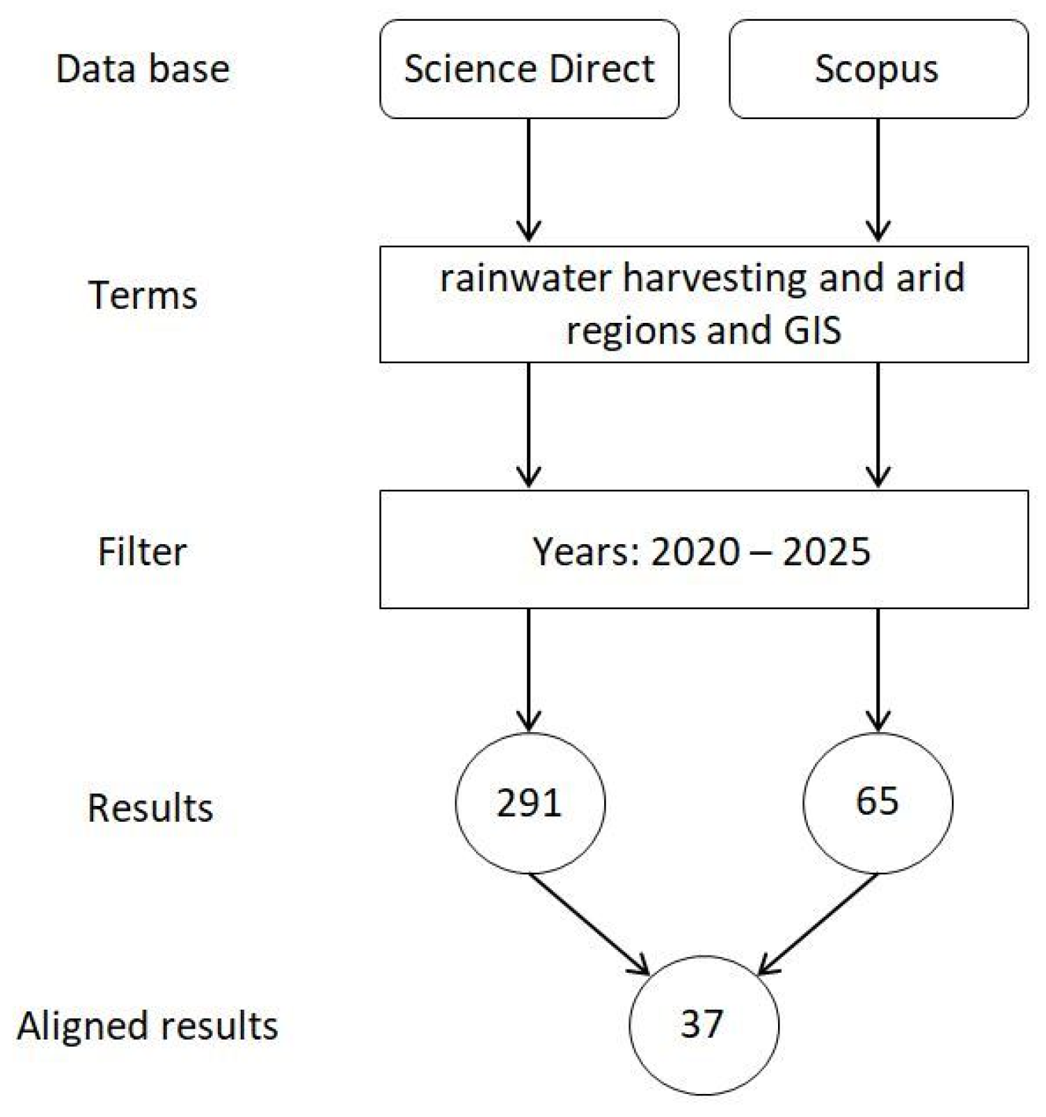
2. Materials and Methods
3. Results and Discussion
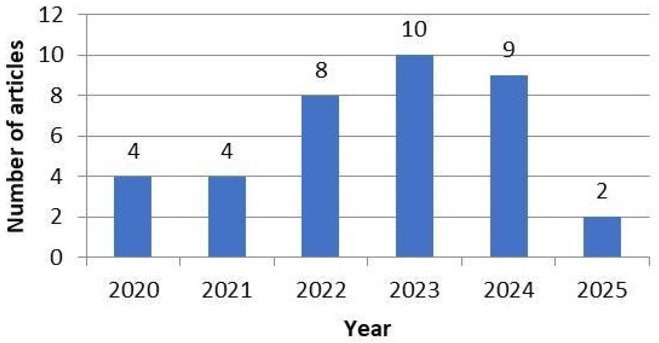
3.1. Framing of Articles
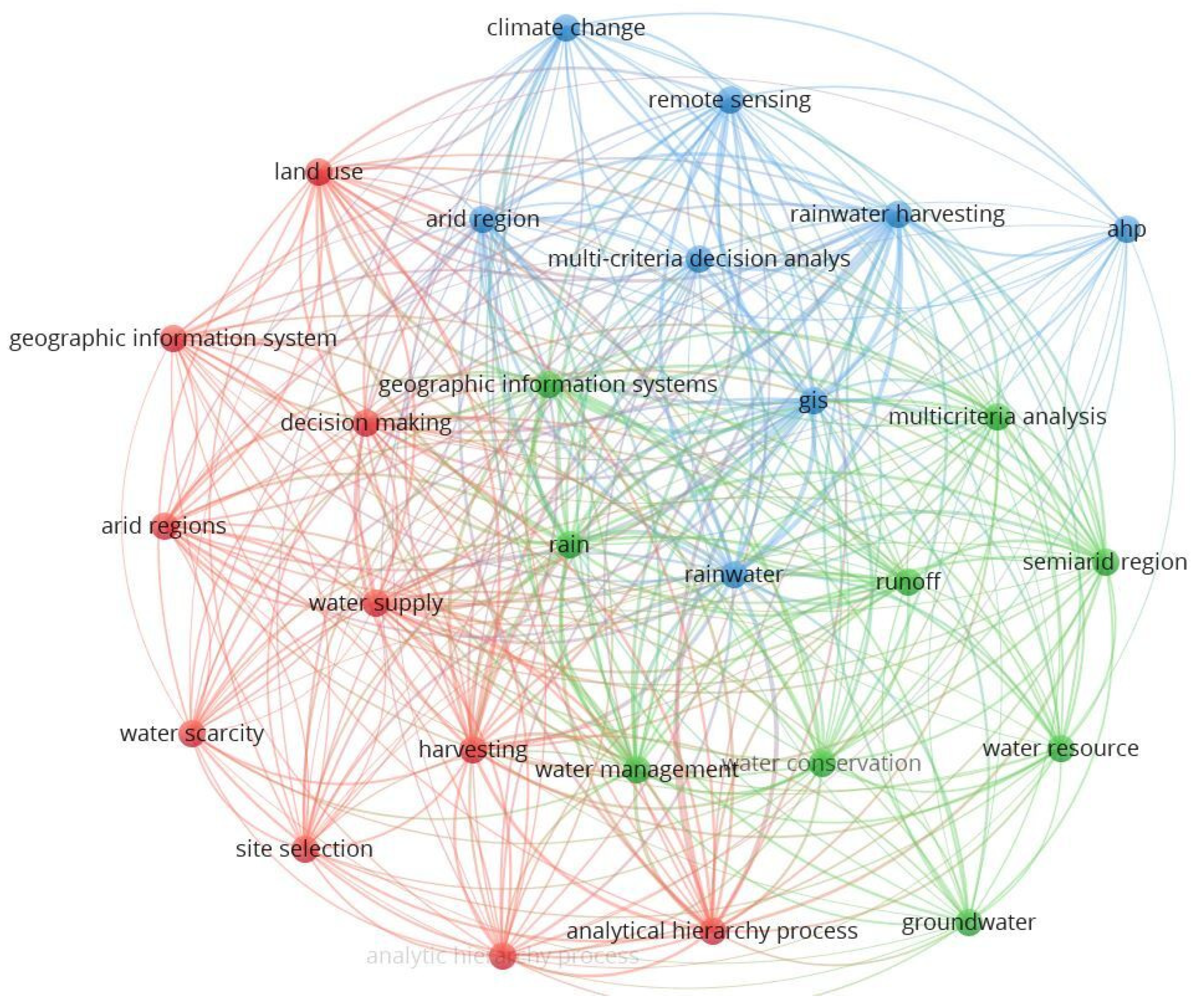
3.2. Methods
3.2.1. Thematic Layers
3.2.2. Weighting Methods
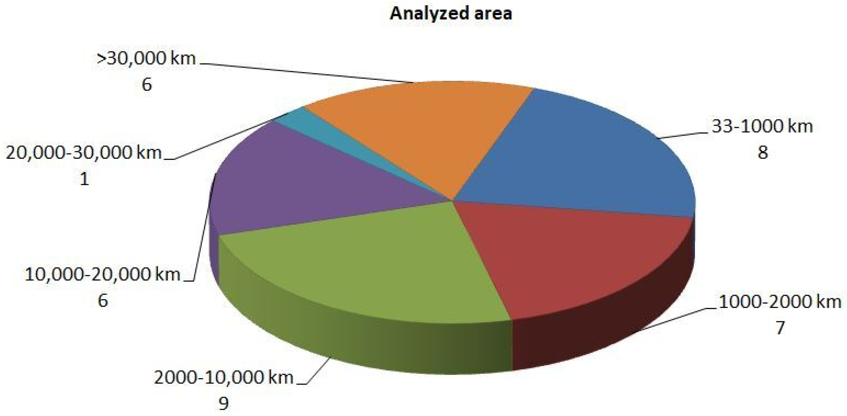
3.2.3. Analysis of Results
4. Conclusions
Author Contributions
Funding
Data Availability Statement
Acknowledgments
Conflicts of Interest
References
- Rosa, L.; Chiarelli, D.D.; Rulli, M.C.; Dell’Angelo, J.; D’Odorico, P. Global agricultural economic water scarcity. Sci. Adv. 2020, 6, eaaz6031. [Google Scholar] [CrossRef]
- UN-Water. The United Nations World Water Development Report 2024: Water for Prosperity and Peace. 2024. Available online: https://unesdoc.unesco.org/ark:/48223/pf0000388948 (accessed on 12 December 2024).
- Asif, Z.; Chen, Z.; Sadiq, R.; Zhu, Y. Climate change impacts on water resources and sustainable water management strategies in North America. Water Resour. Manag. 2023, 37, 2771–2786. [Google Scholar] [CrossRef]
- Ahmad, A.; El-Shafie, A.; Razali, S.F.M.; Mohamad, Z.S. Reservoir optimization in water resources: A review. Water Resour. Manag. 2014, 28, 3391–3405. [Google Scholar] [CrossRef]
- Zhong, R.; Chen, A.; Zhao, D.; Mao, G.; Zhao, X.; Huang, H.; Liu, J. Impact of international trade on water scarcity: An assessment by improving the Falkenmark indicator. J. Clean. Prod. 2023, 385, 135740. [Google Scholar] [CrossRef]
- Richey, A.S.; Thomas, B.F.; Lo, M.H.; Reager, J.T.; Famiglietti, J.S.; Voss, K.; Swenson, S.; Rodell, M. Quantifying renewable groundwater stress with GRACE. Water Resour. Res. 2015, 51, 5217–5238. [Google Scholar] [CrossRef] [PubMed]
- Burek, P.; Satoh, Y.; Fischer, G.; Kahil, M.T.; Scherzer, A.; Tramberend, S.; Nava, L.F.; Wada, Y.; Eisner, S.; Wiberg, D.; et al. Water Futures and Solution-Fast Track Initiative; IIASA: Laxenburg, Austria, 2016. [Google Scholar]
- Gaupp, F.; Hall, J.; Dadson, S. The role of storage capacity in coping with intra-and inter-annual water variability in large river basins. Environ. Res. Lett. 2015, 10, 125001. [Google Scholar] [CrossRef]
- IPCC. Fact Sheets|Climate Change 2022: Impacts, Adaptation and Vulnerability. In Fact Sheet; IPCC: Geneva, Switzerland, 2022. [Google Scholar]
- Do, S.K.; Nguyen, B.Q.; Tran, V.N.; Grodzka-Łukaszewska, M.; Sinicyn, G.; Lakshmi, V. Investigating the Future Flood and Drought Shifts in the Transboundary Srepok River Basin Using CMIP6 Projections. IEEE J. Sel. Top. Appl. Earth Obs. Remote Sens. 2024, 17, 7516–7529. [Google Scholar]
- Tapas, M.R.; Do, S.K.; Etheridge, R.; Lakshmi, V. Investigating the impacts of climate change on hydroclimatic extremes in the Tar-Pamlico River basin, North Carolina. J. Environ. Manag. 2024, 363, 121375. [Google Scholar]
- Aeschbach-Hertig, W.; Gleeson, T. Regional strategies for the accelerating global problem of groundwater depletion. Nat. Geosci. 2012, 5, 853–861. [Google Scholar] [CrossRef]
- Wada, Y.; Van Beek, L.P.; Van Kempen, C.M.; Reckman, J.W.; Vasak, S.; Bierkens, M.F. Global depletion of groundwater resources. Geophys. Res. Lett. 2010, 37, L20402. [Google Scholar] [CrossRef]
- Preeti, P.; Jakhar, S.; Rahman, A. Rainwater harvesting in Australia using an Australia-wide model: A preliminary analysis. In Proceedings of the 2nd International Conference on Water and Environmental Engineering 2019, (iCWEE-2019), Dhaka, Bangladesh, 19–23 January 2019; Volume 19. [Google Scholar]
- de Sá Silva, A.C.R.; Bimbato, A.M.; Balestieri, J.A.P.; Vilanova, M.R.N. Exploring environmental, economic and social aspects of rainwater harvesting systems: A review. Sustain. Cities Soc. 2022, 76, 103475. [Google Scholar] [CrossRef]
- Rahman, A.; Dbais, J.; Islam, S.M.; Eroksuz, E.; Haddad, K. Rainwater harvesting in large residential buildings in Australia. In Urban Development; IntechOpen: Rijeka, Croatia, 2012; pp. 159–178. [Google Scholar]
- Concha Larrauri, P.; Campos Gutierrez, J.P.; Lall, U.; Ennenbach, M. A city wide assessment of the financial benefits of rainwater harvesting in Mexico City. JAWRA J. Am. Water Resour. Assoc. 2020, 56, 247–269. [Google Scholar] [CrossRef]
- Lindoso, D.P.; Eiró, F.; Bursztyn, M.; Rodrigues-Filho, S.; Nasuti, S. Harvesting water for living with drought: Insights from the Brazilian human coexistence with semi-aridity approach towards achieving the sustainable development goals. Sustainability 2018, 10, 622. [Google Scholar] [CrossRef]
- Tolossa, T.T.; Abebe, F.B.; Girma, A.A. Rainwater harvesting technology practices and implication of climate change characteristics in Eastern Ethiopia. Cogent Food Agric. 2020, 6, 1724354. [Google Scholar] [CrossRef]
- Quadros, C.S. Rainwater Harvesting Case Study: FCT/UNL Campus. Master’s Thesis, Universidade NOVA de Lisboa, Lisbon, Portugal, 2010. [Google Scholar]
- Barron, J.; Salas, J.C. Rainwater Harvesting: A Lifeline for Human Well-Bein; UNEP/Earthprint: Nairobi, Kenya, 2009. [Google Scholar]
- Che-Ani, A.I.; Shaari, N.; Sairi, A.; Zain, M.F.M.; Tahir, M.M. Rainwater harvesting as an alternative water supply in the future. Eur. J. Sci. Res. 2009, 34, 132–140. [Google Scholar]
- Ejegu, M.A.; Yegizaw, E.S. Potential rainwater harvesting suit-able land selection and management by using GIS with MCDA in Ebenat District, Northwestern Ethiopia. J. Degrad. Min. Lands Manag. 2020, 8, 2537. [Google Scholar] [CrossRef]
- Adham, A.; Riksen, M.; Ouessar, M.; Ritsema, C.J. A methodology to assess and evaluate rainwater harvesting techniques in (semi-) arid regions. Water 2016, 8, 198. [Google Scholar] [CrossRef]
- Mahmoud, S.H.; Tang, X. Monitoring prospective sites for rainwater harvesting and stormwater management in the United Kingdom using a GIS-based decision support system. Environ. Earth Sci. 2015, 73, 8621–8638. [Google Scholar] [CrossRef]
- Prasad, H.C.; Bhalla, P.; Palria, S. Site suitability analysis of water harvesting structures using remote sensing and GIS–A case study of Pisangan watershed, Ajmer District, Rajasthan. Int. Arch. Photogramm. Remote Sens. Spat. Inf. Sci. 2014, 40, 1471–1482. [Google Scholar] [CrossRef]
- Al-Ghobari, H.; Dewidar, A.Z. Integrating GIS-based MCDA techniques and the SCS-CN method for identifying potential zones for rainwater harvesting in a semi-arid area. Water 2021, 13, 704. [Google Scholar] [CrossRef]
- Othman, A.A.; Al-Maamar, A.F.; Al-Manmi, D.A.M.A.; Liesenberg, V.; Hasan, S.E.; Obaid, A.K.; Al-Quraishi, A.M.F. GIS-based modeling for selection of dam sites in the Kurdistan Region, Iraq. ISPRS Int. J. Geo-Inf. 2020, 9, 244. [Google Scholar] [CrossRef]
- FAO. Land and Water Development Division. In Digital Soil Map of the World and Derived Soil Properties; Land and Water Development Division, FAO: Rome, Italy, 2003. [Google Scholar]
- Mwenge Kahinda, J.; Sejamoholo, B.B.P.; Taigbenu, A.E.; Boroto, J.R.; Lillie, E.S.B.; Taute, M.; Cousins, T. Water Resources Management in Rainwater Harvesting: An Integrated Systems Approach; Water Research Commission Report No. 1563/1/08; Water Research Commission: Pretoria, South Africa, 2008. [Google Scholar]
- Terêncio, D.; Sanches, L.F.; Cortes, R.M.V.; Moura, J.P.; Pacheco, F. Sustentabilidade e armazenamento em Sistemas de Aproveitamento de Águas Pluviais à escala da bacia hidrográfica para utilizações agroflorestais. In X Congresso Ibérico de Gestão e Planeamento da Água: 20 Anos de Continuidade de Uma Nova Cultura da Água. Fluxos de Água, Fluxos de Vida; Fundación Nueva Cultura del Agua: Zaragoza, Spain, 2018; pp. 1–11. [Google Scholar]
- Bichança, M.d.F. Bacias de Retenção em Zonas Urbanas Como Contributo Para a Resolução de Situações Extremas: Cheias Secas. Master’s Thesis, Universidade do Porto, Porto, Portugal, 2006. [Google Scholar]
- de Carvalho, G.D.G.; Sokulski, C.C.; da Silva, W.V.; de Carvalho, H.G.; de Moura, R.V.; de Francisco, A.C.; Da Veiga, C.P. Bibliometrics and systematic reviews: A comparison between the Proknow-C and the Methodi Ordinatio. J. Informetr. 2020, 14, 101043. [Google Scholar] [CrossRef]
- Hashim, H.Q.; Sayl, K.N. Detection of suitable sites for rainwater harvesting planning in an arid region using geographic information system. Appl. Geomat. 2021, 13, 235–248. [Google Scholar] [CrossRef]
- Ahmad, R.; Gabriel, H.F.; Alam, F.; Zarin, R.; Raziq, A.; Nouman, M.; Young, H.-W.V.; Liou, Y.A. Remote sensing and GIS based multi-criteria analysis approach with application of AHP and FAHP for structures suitability of rainwater harvesting structures in Lai Nullah, Rawalpindi, Pakistan. Urban Clim. 2024, 53, 101817. [Google Scholar] [CrossRef]
- Hassan, W.H.; Mahdi, K.; Kadhim, Z.K. Optimal rainwater harvesting locations for arid and semi-arid regions by using MCDM-based GIS techniques. Heliyon 2025, 11, e42090. [Google Scholar] [CrossRef] [PubMed]
- Alwan, I.A.; Aziz, N.A.; Hamoodi, M.N. Potential water harvesting sites identification using spatial multi-criteria evaluation in Maysan Province, Iraq. ISPRS Int. J. Geo-Inf. 2020, 9, 235. [Google Scholar] [CrossRef]
- Hasan, M.M.; Talha, M.; Akter, M.M.; Ferdous, M.T.; Mojumder, P.; Roy, S.K.; Nasher, N.R. Assessing the performance of machine learning and analytical hierarchy process (AHP) models for rainwater harvesting potential zone identification in hilly region, Bangladesh. J. Asian Earth Sci. 2025, 13, 100189. [Google Scholar] [CrossRef]
- Mouhoumed, R.M.; Ekmekcioğlu, Ö.; Özger, M. A holistic multi-tiered decision framework for evaluating rainwater harvesting potential in arid regions: A case study of the southeastern basin of Djibouti. Groundw. Sustain. Dev. 2024, 25, 101090. [Google Scholar] [CrossRef]
- Bera, A.; Mukhopadhyay, B.P. Identification of suitable sites for surface rainwater harvesting in the drought prone Kumari River basin, India in the context of irrigation water management. J. Hydrol. 2023, 621, 129655. [Google Scholar] [CrossRef]
- Aziz, S.; Dasti, M.Y.; Abrar, M.; Mumtaz, F.; Tariq, A. Satellite-based rainwater harvesting sites assessment for Dera Ghazi Khan, Punjab, Pakistan. Environ. Sci. Pollut. Res. 2024, 31, 45399–45413. [Google Scholar] [CrossRef]
- Ezzeldin, M.; Konstantinovich, S.E.; Igorevich, G.I. Determining the suitability of rainwater harvesting for the achievement of sustainable development goals in Wadi Watir, Egypt using GIS techniques. J. Environ. Manag. 2022, 313, 114990. [Google Scholar] [CrossRef] [PubMed]
- Abdelkareem, M.; Mansour, A.M.; Akawy, A. Securing water for arid regions: Rainwater harvesting and sustainable groundwater management using remote sensing and GIS techniques. Remote Sens. Appl. Soc. Environ. 2024, 36, 101300. [Google Scholar] [CrossRef]
- Moumane, A.; Enajar, A.A.; Ghazali, F.E.E.; Khouz, A.; Karmaoui, A.; Al Karkouri, J.; Batchi, M. GIS, remote sensing, and analytical hierarchy process (AHP) approach for rainwater harvesting site selection in arid regions: Feija Plain case study, Zagora (Morocco). Appl. Geomat. 2024, 16, 861–880. [Google Scholar] [CrossRef]
- Abdulrahman, K.Z.; Aziz, S.F.; Karakouzian, M. A Novel Rainfall Classification for Mapping Rainwater Harvesting: A Case Study in Kalar, Iraq. Water 2024, 16, 3311. [Google Scholar] [CrossRef]
- Halder, S.; Bose, S. Addressing water scarcity challenges through rainwater harvesting: A comprehensive analysis of potential zones and model performance in arid and semi-arid regions–A case study on Purulia, India. HydroResearch 2024, 7, 201–212. [Google Scholar] [CrossRef]
- Gavhane, K.P.; Mishra, A.K.; Sarangi, A.; Singh, D.K.; Sudhishri, S. Targeting of rainwater harvesting structures using geospatial tools and analytical hierarchy process (AHP) in the semi-arid region of Rajasthan (India). Environ. Sci. Pollut. Res. 2023, 30, 61682–61709. [Google Scholar] [CrossRef]
- Hart, K. Rainwater harvesting suitability of ground tanks located on stock watering places across Western NSW. Aust. Geogr. 2024, 1, 513–526. [Google Scholar] [CrossRef]
- Alharbi, R.S.; Arunakumaren, N.J.; Mattar, Y.E.; Loni, O.A.; Althobaiti, M.A.; Alshehri, B.M.; Alharbi, R.J.; Alnemari, A.H. Identifying Potential Areas for Rainwater Harvesting in Saudi Arabia. In Proceedings of the International Conference on Climate Change and Ocean Renewable Energy, online, 4–7 November 2022; Springer Nature: Cham, Switzerland, 2022; pp. 129–144. [Google Scholar]
- Alene, A.; Yibeltal, M.; Abera, A.; Andualem, T.G.; Lee, S.S. Identifying rainwater harvesting sites using integrated GIS and a multi-criteria evaluation approach in semi-arid areas of Ethiopia. Appl. Water Sci. 2022, 12, 238. [Google Scholar] [CrossRef]
- Rawat, A.; Panigrahi, N.; Yadav, B.; Jadav, K.; Mohanty, M.P.; Khouakhi, A.; Knox, J.W. Scaling up indigenous rainwater harvesting: A preliminary assessment in Rajasthan, India. Water 2023, 15, 2042. [Google Scholar] [CrossRef]
- Matomela, N.; Li, T.; Ikhumhen, H.O. Siting of Rainwater Harvesting Potential Sites in Arid or Semi-arid Watersheds Using GIS-based Techniques. Environ. Process 2020, 7, 631–652. [Google Scholar] [CrossRef]
- Alrawi, I.; Chen, J.; Othman, A.A.; Ali, S.S.; Harash, F. Insights of Dam site selection for rainwater harvesting using GIS: A case study in the Al-Qalamoun Basin, Syria. Heliyon 2023, 9, e19795. [Google Scholar] [PubMed]
- Aly, M.M.; Sakr, S.A.; Zayed, M.S. Selection of the optimum locations for rainwater harvesting in arid regions using WMS and remote sensing. Case Study: Wadi Hodein Basin, Red Sea, Egypt. Alex. Eng. J. 2022, 61, 9795–9810. [Google Scholar]
- Abdelkareem, M.; Mansour, A.M.; Akawy, A. Delineating the potential areas of rainwater harvesting in arid regions using remote sensing and GIS techniques. Water 2023, 15, 3592. [Google Scholar] [CrossRef]
- Noori, S.; Ghasemlounia, R.; Noori, A.M. Site suitability in water harvesting management using remote sensing data and GIS techniques: A case study of Sulaymaniyah Province, Iraq. In Climate Change, Agriculture and Society: Approaches Toward Sustainability; Springer International Publishing: Cham, Switzerland, 2023; pp. 227–257. [Google Scholar]
- Ahmed, S.O.; Bilgili, A.V.; Cullu, M.A.; Ernst, F.; Abdullah, H.; Hamad, T.A.; Aziz, B.S. Using Geographic Information Systems and Multi-Criteria Decision Analysis to Determine Appropriate Locations for Rainwater Harvesting in Erbil Province, Iraq. Water 2023, 15, 4093. [Google Scholar] [CrossRef]
- Suni, Y.P.K.; Sujono, J.; Istiarto. Identifying potential sites for rainwater harvesting ponds (e mbung) in Indonesia’s semi-arid region using GIS-based MCA techniques and satellite rainfall data. PLoS ONE 2023, 18, e0286061. [Google Scholar]
- Alkaradaghi, K.; Hamamin, D.; Karim, H.; Al-Ansari, N.; Ali, S.S.; Laue, J.; Ali, T. Geospatial technique integrated with MCDM models for selecting potential sites for harvesting rainwater in the semi-arid region. Water Air Soil Pollut. 2022, 233, 313. [Google Scholar]
- Aghaloo, K.; Chiu, Y.R. Identifying optimal sites for a rainwater-harvesting agricultural scheme in iran using the best-worst method and fuzzy logic in a GIS-based decision support system. Water 2020, 12, 1913. [Google Scholar]
- Al-Sababhah, N. The Application of the Analytic Hierarchy Process and GIS to Map Suitable Rainwater Harvesting Sites in (Semi-) Arid Regions in Jordan. Int. J. Geoinform. 2023, 19, 31–44. [Google Scholar]
- Patel, A.; Chaudhari, N. Enhancing water security through site selection of water harvesting structures in semi-arid regions: A GIS-based multiple criteria decision analysis. Water Supply 2023, 23, 4149–4165. [Google Scholar]
- Manaouch, M.; Sadiki, M.; Fenjiro, I. Integrating GIS-based FAHP and WaTEM/SEDEM for identifying potential RWH areas in semi-arid areas. Geocarto Int. 2022, 37, 8882–8905. [Google Scholar] [CrossRef]
- Musaed, H.; El-Kenawy, A.; El Alfy, M. Morphometric, meteorological, and hydrologic characteristics integration for rainwater harvesting potential assessment in Southeast Beni Suef (Egypt). Sustainability 2022, 14, 14183. [Google Scholar] [CrossRef]
- Tahvili, Z.; Khosravi, H.; Malekian, A. Locating suitable sites for rainwater harvesting (RWH) in the central arid region of Iran. Sustain. Water Resour. Manag. 2021, 7, 10. [Google Scholar] [CrossRef]
- Setiawan, O.; Nandini, R. Identification of suitable sites for rainwater harvesting using GIS-based multi-criteria approach in Nusa Penida Island, Bali Province, Indonesia. In IOP Conference Series: Earth and Environmental Science 2022; IOP Publishing: Bristol, UK, 2022; Volume 1039, p. 012010. [Google Scholar]
- Shadeed, S.; Judeh, T.; Riksen, M. Rainwater harvesting for sustainable agriculture in high water-poor areas in the West Bank, Palestine. Water 2020, 12, 380. [Google Scholar] [CrossRef]
- Hamad, S.; Patel, N. Surface Water Potential and Suitable Sites Identification for RWH in the Semi-Arid and Arid Watershed of Wadi Sammalus, Northeast Libya Using GIS and Remote Sensing Approach. In Environmental Applications of Remote Sensing and GIS in Libya; Springer International Publishing: Cham, Switzerland, 2022; Volume 1, pp. 145–173. [Google Scholar]
- Alzghoul, M.; Al-Husban, Y. Rainwater harvesting and storage in Asir, Kingdom of Saudi Arabia, using spatial modeling and geographic information systems. Desalination Water Treat. 2021, 233, 19–29. [Google Scholar] [CrossRef]


| Reference | Cited | Year | JCR | IndO | Ranking |
|---|---|---|---|---|---|
| Hashim and Sayl [34] | 50 | 2021 | 2.5 | 112.5 | 1 |
| Ahmad et al. [35] | 9 | 2024 | 6 | 105 | 2 |
| Al-Ghobari and Dewidar [27] | 41 | 2021 | 3.3 | 104.3 | 3 |
| Hassan et al. [36] | 0 | 2025 | 3.4 | 103.4 | 4 |
| Alwan et al. [37] | 49 | 2020 | 3 | 102 | 5 |
| Hasan et al. [38] | 0 | 2025 | 1.7 | 101.7 | 6 |
| Mouhoumed et al. [39] | 4 | 2024 | 4.9 | 98.9 | 7 |
| Bera and Mukhopadhyay [40] | 13 | 2023 | 5.9 | 98.9 | 8 |
| Aziz et al. [41] | 1 | 2024 | 5.8 | 96.8 | 9 |
| Ezzeldin et al. [42] | 17 | 2022 | 8 | 95 | 10 |
| Abdelkareem et al. [43] | 1 | 2024 | 3.8 | 94.8 | 11 |
| Moumane et al. [44] | 2 | 2024 | 2.5 | 94.5 | 12 |
| Abdulrahman et al. [45] | 0 | 2024 | 3.3 | 93.3 | 13 |
| Halder and Bose [46] | 3 | 2024 | 0 | 93 | 14 |
| Gavhane et al. [47] | 7 | 2023 | 5.8 | 92.8 | 15 |
| Hart [48] | 0 | 2024 | 2.1 | 92.1 | 16 |
| Alharbi et al. [49] | 0 | 2024 | 0 | 90 | 17 |
| Alene et al. [50] | 14 | 2022 | 5.8 | 89.8 | 18 |
| Rawat et al. [51] | 6 | 2023 | 3.3 | 89.3 | 19 |
| Matomela et al. [52] | 35 | 2020 | 3.4 | 88.4 | 20 |
| Alrawi et al. [53] | 4 | 2023 | 3.4 | 87.4 | 21 |
| Aly et al. [54] | 11 | 2022 | 6.2 | 87.2 | 22 |
| Abdelkareem et al. [55] | 3 | 2023 | 3.3 | 86.3 | 23 |
| Noori et al. [56] | 6 | 2023 | 0 | 86 | 24 |
| Ahmed et al. [57] | 2 | 2023 | 3.3 | 85.3 | 25 |
| Suni and Sujono [58] | 1 | 2023 | 3.3 | 84.3 | 26 |
| Alkaradaghi et al. [59] | 10 | 2022 | 3.6 | 83.6 | 27 |
| Aghaloo and Chiu [60] | 30 | 2020 | 3.3 | 83.3 | 28 |
| Al-Sababhah [61] | 3 | 2023 | 0 | 83 | 29 |
| Patel and Chaudhari [62] | 1 | 2023 | 1.9 | 82.9 | 30 |
| Manaouch et al. [63] | 7 | 2022 | 3.5 | 80.5 | 31 |
| Musaed et al. [64] | 3 | 2022 | 3.6 | 76.6 | 32 |
| Tahvili et al. [65] | 14 | 2021 | 2.1 | 76.1 | 33 |
| Setiawan and Nandini [66] | 5 | 2022 | 0 | 75 | 34 |
| Shadeed et al. [67] | 21 | 2020 | 3.3 | 74.3 | 35 |
| Hamad and Patel [68] | 0 | 2022 | 0 | 70 | 36 |
| Alzghoul and Al-Husban [69] | 1 | 2021 | 1 | 62 | 37 |
| Layer | Number of Articles |
|---|---|
| Slope | 35 |
| Land use/land cover (LULC) | 28 |
| Rainfall | 26 |
| Soil | 25 |
| Drainage density | 25 |
| Runoff/surface potential | 14 |
| Stream order | 9 |
| Topographic wetness index (TWI) | 8 |
| Distance to road | 7 |
| Lineament | 7 |
| Vegetation | 7 |
| Curve number (CN) | 6 |
| Elevation | 6 |
| Geological formation | 5 |
| Road network | 4 |
| Faults | 4 |
| Area Range (km2) | Reference | Study Area (km2) | Number of Layers |
|---|---|---|---|
| 33–1000 | Suni and Sujono [58] | 34 | 9 |
| Setiawan and Nandini [66] | 193 | 8 | |
| Ahmad et al. [35] | 235 | 5 | |
| Gavhane et al. [47] | 600 | 5 | |
| Alkaradaghi et al. [59] | 605 | 10 | |
| Matomela et al. [52] | 630 | 6 | |
| Al-Ghobari and Dewidar [27] | 681 | 6 | |
| Abdelkareem et al. [43] | 726 | 13 | |
| 1000–2000 | Moumane et al. [44] | 1146 | 8 |
| Mouhoumed et al. [39] | 1358 | 12 | |
| Hamad and Patel [68] | 1511 | 5 | |
| Abdulrahman et al. [45] | 1746 | 5 | |
| Abdelkareem et al. [55] | 1890 | 13 | |
| Hashim and Sayl [34] | 1953 | 7 | |
| Bera and Mukhopadhyay [40] | 1976 | 12 | |
| 2000–10,000 | Hassan et al. [36] | 2194 | 7 |
| Al-Sababhah [61] | 2633 | 13 | |
| Alrawi et al. [53] | 3366 | 9 | |
| Ezzeldin et al. [42] | 3580 | 11 | |
| Manaouch et al. [63] | 4351 | 5 | |
| Shadeed et al. [67] | 5860 | 7 | |
| Halder and Bose [46] | 6259 | 6 | |
| Tahvili et al. [65] | 8300 | 8 | |
| Alene et al. [50] | 9004 | 7 | |
| 10,000–20,000 | Musaed et al. [64] | 10,646 | 5 |
| Aly et al. [54] | 11,600 | 8 | |
| Aghaloo and Chiu [60] | 12,981 | 12 | |
| Hasan et al. [38] | 13,184 | 11 | |
| Ahmed et al. [57] | 14,837 | 7 | |
| Alwan et al. [37] | 16,072 | 7 | |
| 20,000–30,000 | Patel and Chaudhari [62] | 21,674 | 10 |
| >30,000 | Aziz et al. [41] | 38,778 | 5 |
| Alzghoul and Al-Husban [69] | 77,007 | 10 | |
| Noori et al. [56] | 125,552 | 5 | |
| Hart [48] | 314,429 | 4 | |
| Rawat et al. [51] | 342,239 | 6 | |
| Alharbi et al. [49] | 2,150,000 | 4 |
| Method | Article | Number of Articles |
|---|---|---|
| Analytic Hierarchy Process (AHP) | Al-Ghobari and Dewidar [27]; Hassan et al. [36]; Alwan et al. [37]; Bera and Mukhopadhyay [40]; Aziz et al. [41]; Gavhane et al. [47]; Hart [48]; Alharbi et al. [49]; Alene et al. [50]; Rawat et al. [51]; Alrawi et al. [53]; Abdelkareem et al. [55]; Noori et al. [56]; Ahmed et al. [57]; Suni and Sujono [58]; Patel and Chaudhari [62]; Setiawan and Nandini [66]; Shadeed et al. [67]; Hamad and Patel [68]; Alzghoul and Al-Husban [69]; Abdelkareem et al. [43]; Moumane et al. [44] | 20 |
| Fuzzy Analytic Hierarchy Process (FAHP) | Ahmad et al. [35]; Mouhoumed et al. [39]; Abdulrahman et al. [45]; Aghaloo and Chiu [60]; Manaouch et al. [63] | 5 |
| Weighted Linear Combination (WLC) | Hashim and Sayl [34]; Matomela et al. [52]; Aly et al. [54]; Alkaradaghi et al. [59] | 4 |
| Boolean Approach | Hashim and Sayl [34]; Matomela et al. [52] | 2 |
| Decision Support System (DSS) | Aghaloo and Chiu [60]; Al-Sababhah [61] | 2 |
| Hydrologic Modeling | Ezzeldin et al. [42]; Musaed et al. [64] | 2 |
| Machine Learning (ML) | Hasan et al. [38]; Halder and Bose [46] | 2 |
| Best–Worst Method (BWM) | Aghaloo and Chiu [60] | 1 |
| Fuzzy-Based Index (FBI) | Alkaradaghi et al. [59] | 1 |
| RandomForest (RF) | Halder and Bose [46] | 1 |
| TOPSIS Multi-Criteria | Tahvili et al. [65] | 1 |
| VlseKriterijumska Optimizacija I Kompromisno Resenje (VIKOR) | Mouhoumed et al. [39] | 1 |
| WaTEM/SEDEM | Manaouch et al. [63] | 1 |
| Watershed Modeling | Musaed et al. [64] | 1 |
| Naïve Bayes (NB) | Hasan et al. [38] | 1 |
| Boosted Regression Trees (BRTs) | Hasan et al. [38] | 1 |
| K-Nearest Neighbor (KNN) | Hasan et al. [38] | 1 |
| Reference | Weight (%) | ||||
|---|---|---|---|---|---|
| Rainfall | LULC | Slope | Drainage | Soil | |
| Ahmad et al. [35] | 34 | 11 | 28 | 22 | 5 |
| Hassan et al. [36] | 25 | 6 | 14 | - | 10 |
| Mouhoumed et al. [39] | 23.53 | 6.09 | 19.13 | 2.82 | - |
| Bera and Mukhopadhyay [40] | 6.4 | 18.6 | 23.6 | 12.4 | 9 |
| Ezzeldin et al. [42] | - | 7 | 14 | 9 | - |
| Abdelkareem et al. [43] | 68 | - | 82 | 109 | - |
| Moumane et al. [44] | - | 4.2 | 21.1 | 5.9 | 9.9 |
| Abdulrahman et al. [45] | 40 | 6 | 27 | 10 | 17 |
| Halder and Bose [46] | 29 | 10 | 22 | 6 | 15 |
| Gavhane et al. [47] | - | 13 | 30 | 4 | 8 |
| Hart [48] | - | - | 20 | 40 | 40 |
| Alene et al. [50] | - | 6 | 26 | 10 | 16 |
| Rawat et al. [51] | 10 | 43 | 5 | 17 | 22 |
| Matomela et al. [52] | - | - | 20 | 18 | - |
| Alrawi et al. [53] | 5 | 18 | 22 | - | 10 |
| Aly et al. [54] | - | - | 29.57 | 6.27 | - |
| Abdelkareem et al. [55] | 70 | - | 126 | 112 | - |
| Noori et al. [56] | - | 7 | 27 | 13 | 20 |
| Ahmed et al. [57] | 20 | 10 | 10 | 6 | 10 |
| Alkaradaghi et al. [59] | 28 | 8.8 | 3.4 | - | 5.5 |
| Aghaloo and Chiu [60] | 38 | 8 | 23 | 4 | 15 |
| Al-Sababhah [61] | 18.8 | 2.5 | 12.6 | - | 4.9 |
| Musaed et al. [64] | 19 | 21 | 47 | - | - |
| Setiawan and Nandini [66] | - | 13 | 24 | 7 | 21 |
| Shadeed et al. [67] | 28 | 16 | 12 | - | 10 |
| Reference | Suitability (%) | ||
|---|---|---|---|
| High or Very High | Moderate | Low or Unsuitable | |
| Hashim and Sayl [34] | 6 | 4 | 90 |
| Ahmad et al. [35] | 58.29 | 40 | 1.71 |
| Al-Ghobari and Dewidar [27] | 24 | 110 | 60 |
| Hassan et al. [36] | 31.8 | 68.6 | 34 |
| Alwan et al. [37] | - | - | - |
| Hasan et al. [38] | - | - | - |
| Mouhoumed et al. [39] | 17.99 | 16.87 | 49.09 |
| Bera and Mukhopadhyay [40] | 20.26 | 32.74 | 47 |
| Aziz et al. [41] | 42 | 58 | |
| Ezzeldin et al. [42] | 19 | 25 | 40 |
| Abdelkareem et al. [43] | 31 | 27 | 42 |
| Moumane et al. [44] | 5.24 | 67.65 | 27.09 |
| Abdulrahman et al. [45] | 29 | 28 | 43 |
| Halder and Bose [46] | 57 | - | 10 |
| Gavhane et al. [47] | 32 | - | - |
| Hart [48] | 50.68 | 47.95 | 1.37 |
| Alharbi et al. [49] | - | - | - |
| Alene et al. [50] | 0.02 | 14.85 | 82.86 |
| Rawat et al. [51] | 3.6 | 8.2 | 21.3 |
| Matomela et al. [52] | 26 | 30 | 12.6 |
| Alrawi et al. [53] | 26.2 | 7.8 | 66 |
| Aly et al. [54] | - | - | |
| Abdelkareem et al. [55] | 58.51 | 21.26 | 20.21 |
| Noori et al. [56] | 61 | 11 | 28 |
| Ahmed et al. [57] | 44.16 | 35.69 | 20.15 |
| Suni and Sujono [58] | 27 | 61 | 13 |
| Alkaradaghi et al. [59] | 52.3 | 30.7 | 14.6 |
| Aghaloo and Chiu [60] | - | - | - |
| Al-Sababhah [61] | 12.31 | - | 55.77 |
| Patel and Chaudhari [62] | - | - | - |
| Manaouch et al. [63] | - | - | - |
| Musaed et al. [64] | - | - | - |
| Tahvili et al. [65] | 45.48 | 54.2 | |
| Setiawan and Nandini [66] | 38 | - | - |
| Shadeed et al. [67] | 61 | - | - |
Disclaimer/Publisher’s Note: The statements, opinions and data contained in all publications are solely those of the individual author(s) and contributor(s) and not of MDPI and/or the editor(s). MDPI and/or the editor(s) disclaim responsibility for any injury to people or property resulting from any ideas, methods, instructions or products referred to in the content. |
© 2025 by the authors. Licensee MDPI, Basel, Switzerland. This article is an open access article distributed under the terms and conditions of the Creative Commons Attribution (CC BY) license (https://creativecommons.org/licenses/by/4.0/).
Share and Cite
Silva, F.F.C.; Pacheco, F.A.L.; Sanches Fernandes, L.F. Methodologies for Locating Suitable Areas for Rainwater Harvesting in Arid Regions: A Review. Water 2025, 17, 1500. https://doi.org/10.3390/w17101500
Silva FFC, Pacheco FAL, Sanches Fernandes LF. Methodologies for Locating Suitable Areas for Rainwater Harvesting in Arid Regions: A Review. Water. 2025; 17(10):1500. https://doi.org/10.3390/w17101500
Chicago/Turabian StyleSilva, Franco Felix Caldas, Fernando António Leal Pacheco, and Luís Filipe Sanches Fernandes. 2025. "Methodologies for Locating Suitable Areas for Rainwater Harvesting in Arid Regions: A Review" Water 17, no. 10: 1500. https://doi.org/10.3390/w17101500
APA StyleSilva, F. F. C., Pacheco, F. A. L., & Sanches Fernandes, L. F. (2025). Methodologies for Locating Suitable Areas for Rainwater Harvesting in Arid Regions: A Review. Water, 17(10), 1500. https://doi.org/10.3390/w17101500