Article

The Hydrogeochemical Characteristics and Formation Mechanisms of the High-Salinity Groundwater in Yuheng Mining Area of the Jurassic Coalfield, Northern Shaanxi, China

1
Key Laboratory of Coal Resources Exploration and Comprehensive Utilization, Ministry of Natural Resources, Xi’an 710021, China
2
Shaanxi Coal and Chemical Technology Research Institute Co., Ltd., Xi’an 710010, China
*
Author to whom correspondence should be addressed.
Water 2025, 17(10), 1459; https://doi.org/10.3390/w17101459
Submission received: 7 April 2025 / Revised: 26 April 2025 / Accepted: 2 May 2025 / Published: 12 May 2025
(This article belongs to the Section Hydrogeology)

Abstract

:
In the Yuheng mining area (Jurassic coalfield, northern Shaanxi, China), the Yan’an Formation groundwater is characterized by elevated salinity, posing challenges for mine water pollution control and regional water resource management. However, the spatial distribution patterns and formation mechanisms of this high-salinity groundwater remain poorly studied. This study integrates hydrogeochemical data from 18 coal mines, analyzing the spatial salinity variations, major ion compositions and isotopic signatures. Combined with the evolution characteristics of ancient sedimentary environments and the composition analysis of rock salt minerals in the coal rock interlayers, the formation mechanism of high salinity water was explored. The results indicate that the groundwater mineralization degree of the Yan’an Formation in the Jurassic strata encountered in the Yuheng mining area is the highest, showing a decreasing trend upwards. On the plane, the western and northern regions are generally higher than the eastern and southern regions. The highest mineralization level of groundwater can reach 36.25g/L, and the high mineralization hydrochemical type is mainly SO4-Na·Ca type, with occasional Cl-Na type in areas with extremely high mineralization level. The cause analysis shows that the highly mineralized groundwater in the Yuheng mining area comes from atmospheric precipitation, which infiltrates and dissolves salt rocks. In addition, the mining area is located in the arid area of northern Shaanxi, with insufficient water supply and no obvious structural faults, and has good sealing properties, thus exhibiting the characteristics of high mineralization. These mechanisms provide a formation model for the high-salinity groundwater in Jurassic coal-bearing strata, offering critical implications for predictive hydrogeochemical modeling and sustainable water management in arid mining regions.

1. Introduction

As the backbone of China’s primary energy structure (currently contributing 66.6% of national energy consumption), coal resources fundamentally underpin both national economic development and energy security, particularly given China’s unique geological endowment characterized by “coal abundance versus petroleum scarcity” [1]. The Jurassic Coalfield in northern Shaanxi boasts proven reserves exceeding 150 billion metric tons. The Jurassic coalfield in Northern Shaanxi boasts proven reserves exceeding 150 billion metric tons. Nevertheless, large-scale coal extraction in this region faces critical environmental paradoxes. Located within ecologically fragile arid to semi-arid regions plagued by chronic water scarcity, this area exhibits fundamental tensions between large-scale extraction of thick coal seams and sustainable conservation of vulnerable Quaternary Aquifer Systems [2,3,4]. Within the Yuheng mining area (3800 km2 core production zone), groundwater systems in coal-bearing strata exhibit distinct hypersalinity characteristics, and the discharge of highly mineralized water can cause the pollution of surface water and soil, as well as damage the ecological environment [5,6,7,8,9,10]. Studying the hydrochemical characteristics, occurrence patterns, and causal mechanisms of highly mineralized water can provide important references for the treatment of underground water extracted from coal mines and the protection of the ecological environment.
Contemporary hydrogeological investigations demonstrate that the spatial distribution of coal mine water systems is predominantly governed by regional structural frameworks. In North China’s coal basins, systematic characterization has revealed transient hydraulic connectivity between Ordovician karst aquifers and Carboniferous–Permian coal measures, evidenced by measurable hydraulic gradients (0.08‰) facilitating vertical leakage recharge. Contrastingly, the Jurassic coalfields in northern Shaanxi exhibit a distinctive hydrostratigraphic architecture where laterite aquitards spatially coupled with Quaternary aquifers regulate recharge dynamics. Field measurements document intact laterite permeability coefficients of 0.002–0.008 m/d, yet structural weakening zones exhibit 2–3 orders of magnitude higher conductivity, posing contamination risks through aquitard breaching [11,12,13]. Hydrogeochemical profiling delineates polyphase mineralization mechanisms. In Shaanxi’s coal measures, pyrite–gypsum redox reactions generate hypersaline mine water (TDS 5–15 g/L, maximum 23.5 g/L), with Ca2+/SO42− equivalent ratios (1:1.8) confirming gypsum dissolution dominance. Southern high-sulfur deposits exhibit Acidithiobacillus-mediated acid mine drainage (pH 3.5–5.0) through FeS2 bio-oxidation, producing Fe3+-SO42− acidic systems with Eh values below −150 mV [12,13,14,15]. The intensive extraction of thick seams (8–15 m) induces fracture zones extending 20–30 times the mining height, creating hydraulic shortcuts between roof aquifers and surface water. The Yushen mining complex exemplifies the severe impacts, with individual mines discharging >7 million m3 annually, correlating to groundwater level declines of 1.5–3.0 m/a [11]. Emerging challenges include the following: (1) >25% uncertainty in deep 3D hydrogeological models due to structural heterogeneity; (2) the knowledge gaps in microbially catalyzed mineral dissolution kinetics; (3) Piper diagram limitations for hypersaline waters (TDS > 10 g/L) manifesting as 70% data clustering in high-Cl domains; and (4) 40% of dewatered resources remain unutilized, intensifying water–energy nexus conflicts [16,17,18]. Strategic priorities emphasize developing coupled hydrogeochemical transport models enhanced by machine learning algorithms, deploying distributed fiber-optic sensing networks for real-time monitoring, and advancing zero-liquid-discharge technologies integrating membrane crystallization with salt recovery.
Research on the formation mechanisms of highly mineralized water in coal mines holds significant scientific importance for water environment management and ecological security in mining areas. In this study, we employed an integrated hydrochemical sampling–testing methodology, focusing on the hydrogeological units of the Jurassic coalfield in the Yuheng mining area, in northern Shaanxi. We collected three-dimensional layer-controlled groundwater mineralization data from 18 typical mines (totaling 362 samples). Through a multi-parameter hydrochemical analysis, stable isotopic fingerprinting techniques (δD-δ18O), and sedimentary facies-controlled numerical inversion, we established a spatial heterogeneity model for high-TDS water, revealing that its formation mechanisms dominated by water–rock interactions at paleo-depositional interfaces (gypsum/salt layer dissolution contribution>68%), modern mining-induced fracture network permeability variations (hydraulic conductivity increased by 2–3 orders of magnitude), and climate–ecological degradation (31% reduction in groundwater recharge). These findings provide theoretical support for tracing mineralization sources, predicting high-salinity mine water distribution, and optimizing pollution prevention strategies. This research advances salt resource recovery technologies to mitigate water scarcity while reducing secondary contamination risks to aquifers and soil ecosystems. Furthermore, by elucidating water–rock reaction patterns under coupled mining–geological stresses, it offers critical engineering guidance for building deep mining water hazard prevention systems and achieving coordinated water-energy resource management in mining regions.

2. Hydrogeological Setting

The Yuheng mining area is geologically situated in the central sector of Yulin City, Shaanxi Province, administratively spanning Yuyang District, Hengshan County, and Jingbian County. It occupies the central-western core of the Jurassic coalfield in northern Shaanxi (Figure 1a). The area is bounded by the Yushen mining area to the north, the Yuxi River and the outcrop boundary of the No. 3 coal seam to the east, the provincial border between Shaanxi and Inner Mongolia to the west, and the Yitai-Zhongyin Railway to the south. The Wuding River bifurcates the mining zone into two sub-regions: the ‌Yuheng North Area‌ (38°30′ N to the Wuding River) and the ‌Yuheng South Area‌ (south of the Wuding River to the Taiyuan–Zhongyin Railway).
Structurally, the mining area lies within the central-southern Shaanbei Slope of the Ordos Basin, characterized by a monoclinic framework with localized flexural deformation zones in the southeastern sector. Subsurface investigations reveal concealed faults and low-relief anticlines in adjacent regions (Figure 1a). Stratigraphically, the NE-SW trending formations exhibit a gentle dip angle (<5°), sequentially comprising Triassic (basal unit), Jurassic (coal-bearing horizons), Cretaceous, Neogene, and Quaternary Systems. Detailed lithological profiles and thickness variations are cataloged in Table 1.
Hydrologically, surface drainage converges via the Yuxi River tributaries into the Wuding River, ultimately discharging into the Yellow River, with pronounced seasonal discharge variability (Figure 1b). The groundwater regime is categorized into two distinct systems: Cenozoic unconsolidated aquifers, comprising porous and fissure–porous groundwater within Quaternary–Neogene gravel layers, and Mesozoic clastic bedrock aquifers, featuring fissure-porous phreatic water and interlayer confined water in Jurassic–Cretaceous sandstone sequences. Spatial distributions and hydrogeochemical parameters are systematically tabulated in Table 1.

3. Sample Collection and Analytical Testing

Water samples were collected in high-density polyethylene (HDPE) bottles with hermetic plastic screw caps, which were pre-rinsed five times using in situ groundwater from the target aquifer to mitigate exogenous contamination.
Hydrochemical characterization was conducted using via inductively coupled plasma optical emission spectrometry (ICAP6500DUO ICP-OES) for major ions (K+, Na+, Ca2+, Mg2+, and SO42−) and trace elements (B, Li, and Sr), achieving long-term instrumental precision of 2.0% with relative standard deviations (RSDs) of 1.9–2.6%. Anion concentrations (Cl, Br, and HCO3) were quantified using an ICS-5000+ ion chromatograph, validated by ion balance errors of 1.2–2.6% (with a mean 1.8%). The stable isotope analysis was conducted employing a isotope ratio mass spectrometer (MAT253,Thermo Fisher Scientific, Waltham, MA, USA) system: hydrogen isotopes (δD) were measured by equilibrating 0.2 mL aliquots with He/H2 (98:2) at 28 °C for 1 h, while oxygen isotopes (δ18O) were measured by utilizing 0.5 mL aliquots under He/CO2 (99.7:0.3) at 28 °C for 18 h, followed by chromatographic separation at 70 °C. Calibration against VSMOW standards yielded uncertainties of ±2.0‰ (δD) and ±0.3‰ (δ18O). The tritium (3H) analysis involved electrolytic enrichment (150 g distilled water + 2 g Na2O2, 120 h electrolysis to ~15 g residual) and vacuum distillation, with detection performed using a Quantulus1220 liquid scintillation spectrometer (detection limit: 1 TU; precision: ±0.05 TU).
Sedimentary reconstruction integrated sand-to-mud ratios, well-logging data, and core petrography, cross-referenced with hydrogeochemical evolution and groundwater dynamics to determine the origin of the high-salinity groundwater in the Yan’an Formation.

4. Analytical Test Results

This study implements systematic multi-phase sampling and statistical data compilation over a thirty-year investigation period. Through comprehensive monitoring across 18 mine fields in the Yuheng Jurassic Coalfield, we have assembled 137 mineralization datasets and 101 hydrochemical datasets characterizing the Yan’an Formation. The isotopic analyses included 34 hydrogen–oxygen (δD and δ1⁸O) and 16 tritium (3H) datasets, utilizing gas equilibration (Gasbench II) and liquid scintillation spectrometry (Quantulus1220, PerkinElmer, Suomen tasavalta). The groundwater salinity data (109 sets) spanned five stratigraphic units: Quaternary (17 sets, 0.14–0.66 g/L, avg. 0.31 g/L), the Luohu Formation (6 sets, 0.32–0.75 g/L, avg. 0.47 g/L), the Anding Formation (23 sets, 0.37–9.38 g/L, avg. 3.58 g/L), the Zhiluo Formation (24 sets, 0.98–36.25 g/L, avg. 5.35 g/L), and the Yan’an Formation (39 sets, 1.23–36.25 g/L, avg. 7.47 g/L). Statistical validation via Pearson correlation confirmed a salinity gradient increasing from the Quaternary System to the deeper Yan’an Formation, with data aggregation and unit conversions compliant with China’s Geological Survey standards. Multi-parameter ranges and mean values were calculated using RSD-controlled methods (RSD < 5%), ensuring reproducibility and alignment with hydrogeochemical modeling requirements (Table 2).
Overall, the Jurassic groundwater in the Yuheng mining area has the characteristic of high mineralization. The mineralization test and analysis data were plotted, and the planar distribution of the mineralization in the Yan’an, Zhiluo, and Anding Formations is shown in Figure 2.
Upon an analysis was conducted on horizontal distribution characteristics of the Jurassic groundwater in the Yuheng mining area, and it was found that the mineralization was higher in the western and central areas of the mining area than it is in the eastern and northern regions. The formation of three high-value centers of mineralization was observed. the The Yan’an Formation demonstrated a high mineralization value of 10.00 g/L, and this was exceeded by the following: the high-value centers of Hengshan Polo, Hongshiqiao and Weiqiang high-value centers, which reached up to 36.25 g/L, the high-value centers of northwestern Wusu Haize and Hongshiqiao–Weijiasheng, and high-value centers of Hongdunjie and Haizetan in the southwestern part.
The mineralization value of the groundwater in the Jurassic stratum decreased vertically from the bottom up. The Yan’an Formation exhibited the highest mineralization values, with most of them being higher than 8.00 g/L, with an average of 7.45 g/L; and the groundwater belonged to the category of brackish and saline water. The groundwater of the Zhi Luo Formation showed an average mineralization value of 5.35 g/L; 5.35 g/L, this area mostly comprised slightly brackish and saline water, with the western area containing saline water and some of the eastern area containing freshwater. The groundwater of the Anding Formation group showed an average mineralization value of 3.58 g/L; this area mainly comprised slightly salty water, with some of the area comprising salty water or fresh water.

5. Discussion

5.1. Typical Characteristic Ion Distribution

The hydrochemical classification of groundwater is primarily based on ionic composition combinations and mineralization degree (M), integrated with genetic environments for comprehensive categorization. Typically, the levels of six major ions in groundwater (Na+, Ca2+, Mg2+, HCO3, SO42, and Cl, with K+ combined with Na+) and mineralization serve as the classification criteria. By combining anions and cations with concentrations exceeding a 25% milliequivalent per liter, 49 hydrochemical types are defined (e.g., HCO3-Ca type and Cl-Na type). A Piper trilinear diagram of the hydrochemical composition of the groundwater at different levels in the Yuheng mining area (Figure 3) shows the following: The hydrochemical type of the groundwater gradually changes from the HCO3-Ca type to the SO4-Na or Cl-Na type from the top to the bottom. The groundwater of the Quaternary System and the Luohe Formation is located in the middle and left parts of the rhombus of the Piper trilinear diagram. Additionally, the groundwater in the Quaternary System predominantly exhibits HCO3-Ca hydrochemical facies, whereas the Cretaceous Luohe Formation is mainly of the HCO3-Na type, with some of it being of the HCO3-Na type. The groundwater of the Jurassic Anding Formation is dominated by the HCO3-Na·Ca type, and the main reservoir of highly mineralized water in the Jurassic Yan’an Formation is dominated by the SO4-Na type. The groundwater of the Zhiluo Formation is located at the right end of the rhombus. and the groundwater of the Jurassic Yan’an Formation is dominated by the SO4-Na and the SO4-Na·Ca types. The Jurassic Yan’an Formation, which is the main reservoir of highly mineralized water, is dominated by the SO4-Na type. Although the SO4-Na type is dominant, the Cl-Na type water is observed in the Hengshan–Boro Kamchat area and the Weiqiang coal mining area with extremely high mineralization. Individual samples from the Shixtai Kamchat area, which has relatively low mineralization, indicate SO4-Ca-type water chemistry, and individual samples from the Fanjiahe coal mine indicate HCO3-Ca-type water. The Yan’an Formation’s hypersaline groundwater exhibits a characteristic anion suite dominated by SO4², Cl, and HCO3. Notably, peak mineralization zones demonstrate extreme ionic concentrations, with sulfate levels peaking at 6.39g/L and chloride attaining 21.69g/L in maximum mineralized sectors. The Cl and SO42− increase with an increase in the degree of mineralization, and showing a good correlation with the degree of mineralization. The main cations are Na+, Ca2+, and Mg2+. Na+ content was the highest, at up to 5.99 g/L, which also showed an excellent linear relationship with mineralization degree, indicating that a high mineralization degree may be related to the dissolution of salt minerals and the concentration of the water body by evaporation.
A Na-K-Mg equilibrium map of the Jurassic groundwater in the Yuheng mining area shows that most of the data from the high-mineralization layers fall into some equilibrium zones (Figure 4), indicating strong sealing or weak groundwater circulation and a renewal ability.

5.2. Combination Characteristics of Hydrochemical Parameters

The characteristics of the combination of hydrochemical parameters can reveal the origin of groundwater [19,20,21,22,23,24]; given that the Yan’an Formation is the main layer containing high-mineralization water, this study focuses on an analysis of the characteristics of the combination of the hydrochemical parameters of groundwater samples from the Yan’an Formation. Accordingly, a γCa + Mg/γHCO3 + SO4 value is used to determine the source of groundwater with Ca and Mg. Values greater than one indicate these ions mainly come from the dissolution of carbonate minerals. Values less than one indicate they mainly come from the dissolution of silicate minerals or sulfate minerals, and values equal to one indicate the source of is a mixed dissolution of the two [25,26]. For most of the samples tested in this paper, the value of γCa + Mg/γHCO3 + SO4 is less than one, indicating that the Ca and Mg ions mainly come from the dissolution of silicate minerals or the dissolution of sulfate minerals. The value of the commonly used sodium-chloride coefficient (γNa+/γCl) indicates the cause of groundwater; for standard seawater, the γNa+/γCl is 0.85~0.87. The rock salt dissolution and filtration cause of a groundwater γNa+/γCl is one, the atmospheric water infiltration of a groundwater γNa+/γCl is greater than one, and the water–rock interactions involving the impact of sedimentary water have a γNa+/γCl of less than 0.87, according to the paper by Yuheng. In this paper, the stratigraphic water of the Yan’an Formation in the mining area as a whole has a high NaCl coefficient related to water infiltration and leaching, (γNa+/γCl) (Figure 5). The atmospheric water infiltration leaching of rock salt minerals such as magnetite is directly related to what causes the sedimentary basins of ancient water bodies to concentrate near where the magnetite precipitation of the brackish water stage occurs, which is conducive to the organic matter of a coal formation. The calcium and magnesium coefficient (γCa2+/γMg2+) can reflect the closure of the formation of stratum water, usually the longer the groundwater burial time, the better the closure, the higher the degree of metamorphism, and the greater the calcium and magnesium coefficient. The calcium and magnesium coefficient of deep water is generally greater than three. The calcium and magnesium coefficient of the underground body of the coal mine of the Yan’an group in the Yuheng mining area is higher overall, indicating that the stratum closure is better, which provides a good reduction of the coal-forming environment. The desulfurization coefficient (100γSO42−/2γCl) reveals the redox environment of deep geothermal water. The reaction of sulfate reduction is very common in groundwater, and the desulfurization effect can reduce sulfate to hydrogen sulfide as the main product. The desulfurization effect occurs in a reduction environment, so the desulfurization coefficient can be used as an environmental indicator, usually the better the groundwater closure, the smaller the desulfurization coefficient. The desulfurization coefficient serves as a valuable environmental indicator due to its dependence on reducing conditions during the desulfurization process. A lower desulfurization coefficient typically reflects better groundwater confinement, as shown by an inverse relationship between these parameters. Our investigation reveals that groundwater samples from the Yan’an Formation coal mine in the Yuheng mining area exhibit significantly higher desulfurization coefficients (Figure 5) compared to regional groundwater averages in the same formation. This elevated coefficient observed in the formation water may be attributed to atmospheric water infiltration and subsequent leaching of sulfate-bearing rocks within the Yan’an Formation.
Gibbs [27], through a systematic analysis of the hydrochemical characteristics of different water bodies (oceans, rivers, lakes, atmospheric precipitation, etc.) around the world, concluded that the main factors controlling the source of solutes in the natural surface water and groundwater are rock weathering, atmospheric deposition, evaporation–crystallization etc., of which the designed semi-logarithmic coordinate diagrams can be used to identify the hydrochemical genesis of the water bodies. The groundwater Cl/(Cl + HCO3) in the Yan’an Formation of the Yuheng mining area ranges from 0.09 to 0.98, Na+/(Na+ + Ca2+) ranges from 0.25 to 0.95, and TDS ranges from 1.24 to 36.2 g/L. As can be seen from the Gibbs plot (Figure 6), the distribution of the groundwater data is predominantly in the evaporation-concentration-type intervals in the upper-right corner, which is indicative of the source of the evaporation-crystallization solutes. According to the end-element diagram method proposed by Gaillardet [28], after analyzing the groundwater of the Yan’an Formation in the Yuheng mining area (Figure 7), it can also be observed that the groundwater data of the Yan’an Formation in the Yuheng mining area are mostly distributed in the lower-left corner, indicating that the solute source is mainly related to evaporative rock salt solubility filtration.

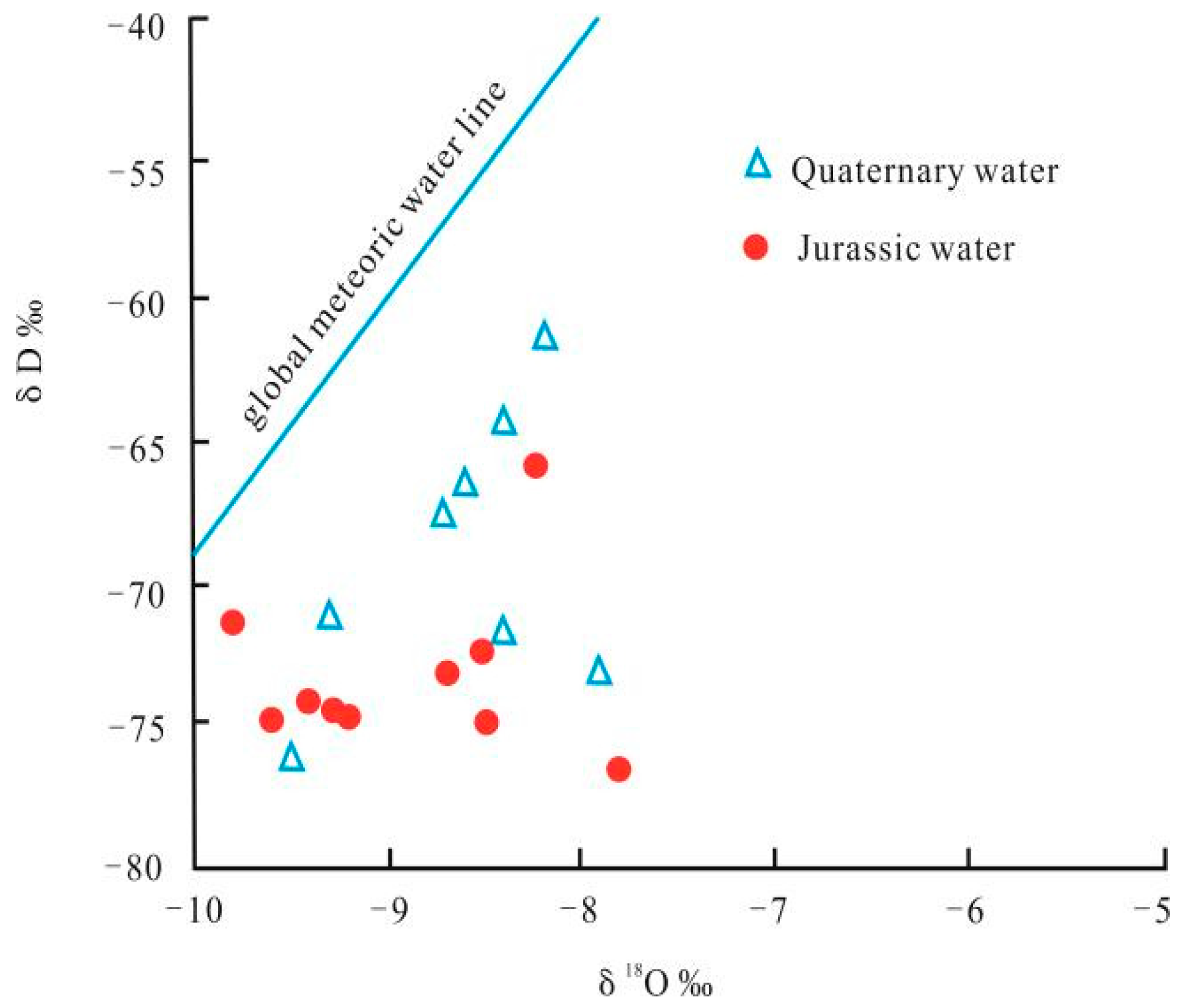
5.3. Hydrogen and Oxygen Isotope Characteristics

The hydrogen and oxygen isotopic composition of groundwater serves as a valuable indicator of its origin and evolutionary dynamics, thereby enabling the tracing of its sources and circulation mechanisms. A hydrogen and oxygen isotope analysis was conducted on the groundwater of the Quaternary and Yan’an formations in four coal mines, Yuan Datan, Wei Qiang, Xiaojihan, and Balasu, located in the Yuheng mining area of northern Shaanxi. According to the correlation graph of the hydrogen–oxygen isotope composition in geothermal water (Figure 8), it can be clearly observed that the δD-δ18O coordinates of the groundwater in the Yuheng mining area are located near the atmospheric precipitation line in northern Shaanxi, indicating that groundwater mainly comes from atmospheric precipitation and surface water supply. The distribution of the hydrogen and oxygen isotope composition in the groundwater is relatively concentrated, with δD ranging from −77.3‰ to −70.8‰, with an average value of −72.6‰, and δ18O ranging from −10.9‰ to −9.8 ‰, with an average value of −10.4‰. An analysis of the hydrogen and oxygen isotope characteristics indicates the origin of the formation of water is atmospheric precipitation in t. Compared with the low salinity formation water in the Quaternary, the hydrogen isotope of high-salinity water in the Jurassic coalfield is relatively lighter, while the oxygen isotope is heavier. The hydrogen isotope of the saline water in the Jurassic coalfield is lower, indicating that it may have been a dry and cold environment at that time. The slightly lower evaporation intensity led to a relatively weak hydrogen isotope drift. Due to the longer burial time, the water–rock reaction occurred more fully, resulting in saline water with a lighter hydrogen isotope composition but a heavier oxygen isotope composition.

5.4. Age of High Mineralization Water Age

This article employs the tritium content analysis of water samples based on Clark and Peter’s (1997) [29] proposed empirical classification scheme for groundwater age in mainland China. The empirical classification of groundwater age is shown in Table 3. Groundwater samples from the Yan’an Formation and the Quaternary Systems of the Yuan Datan, Wei Qiang, Xiaojihan, and Balasu coal mines, respectively, groundwater samples were tested for tritium content, and the tritium content in the groundwater of the Yan’an Formation was mostly in the range of 1.0–5 TU, belonging to the category of mixed water in the sub-modern and recent periods.

5.5. Primitive Sedimentary Environment

In the Yan’an period, the Jurassic coalfield in northern Shaanxi Province as a whole was a terrestrial fluvial and lacustrine deposition, and it mainly developed a fluvial depositional system, a deltaic depositional system, and a lacustrine depositional system [30,31,32,33]. In this study, the Yan’an Formation in the Yuheng mining area is analyzed using single and continuous well profiles of typical boreholes in the Yan’an Formation, such as zk707, zk701, zk505, and zk303. Drawing on the stratigraphic sequences of the Yan’an Formation and the analyses of the sedimentary phases of the Yan’an Formation in previous studies [26,27,28], the Yan’an Formation in the Yuheng mining area is classified into the three stratigraphic sequences of Ⅰ, Ⅱ, and Ⅲ from the bottom to the top, which correspond to the early, middle, and late depositional periods of Yan’an. Additionally, the sandstone and mudstone of each period are analyzed in depth and classified, and detailed sand and mudstone statistics are obtained for each period. Contour maps of surface stratigraphic thickness, sand and mudstone thickness, and sand-to-mud ratios are drawn to analyze the paleo-sedimentary environment of the Yan’an period and to construct a sedimentary phase diagram of the Yan’an Formation in the Yuheng mining area for each period (Figure 9).
The sedimentary period of the Yan’an Formation in the Yuhong mining area represents a continental, arid, lake sedimentary environment. During this period, the mining area was situated along the lake’s edge. From the early to the late stage, the lake progressively shrank, and by the late stage, a restricted lake developed in the southeastern part of the mining area. A comparative analysis of the sedimentary facies map (Figure 9) and the mineralization distribution map shows a clear correlation between sedimentary facies distribution and mineralization. In the western, southwestern, and central regions, where shallow or restricted lakes are formed, the groundwater mineralization levels are generally higher. In contrast, groundwater mineralization is lower in the northern and eastern regions, where delta, river, or alluvial plain deposits are present. The lake shrinkage sedimentary environment creates favorable conditions for the development of evaporite salts.

5.6. Analysis of Rock Salt Minerals in Coal Rock Interlayers

Saltstone minerals are found in the coal rocks of the Yan’an Formation in the Yuchang mining area of the northern Shaanxi Province, with gypsum dominating the rock salt minerals (Table 4), accounting for an average of more than 85%, followed by pyrite, rhodochrosite, and a small number of clay minerals, and each sample has a very low content of hard gypsum. Rhodochrosite is a typical rock-forming mineral, and lake-marsh-phase rhodochrosite is often symbiotic with coal seams, while pyrite is formed by a sulfate reduction reaction, reflecting the fact that the Yan’an Formation has relatively reduced preservation conditions. The salt minerals deposited during the Yan’an period reveals that those easily soluble in water have been dissolved in the groundwater.

5.7. Formation Mechanism of High-Salinity Water

In summary, the ionic distribution and compositional signatures of the highly mineralized groundwater in the study area suggest a dual solute origin; one that is predominantly derived from evaporite dissolution (particularly sulfate-rich minerals) with supplementary contributions from silicate weathering. A stable isotope analysis (δ2H and δ1⁸O) of the groundwater unequivocally demonstrates its meteoric origin, while radiometric age-dating analyses reveal the contemporary groundwater is a mixed system containing both sub-modern and recent hydrological components.
The saline groundwater reservoir is stratigraphically constrained within primary evaporite depositional sequences. The mining area’s structural framework exhibits remarkable simplicity, characterized by an absence of significant fault systems. This hydrogeological configuration results in the following: (1) attenuated surface water infiltration due to limited preferential pathways, (2) weak hydraulic connectivity between aquifers, (3) a strong vertical confinement of individual groundwater units, and (4) protracted groundwater residence times with sluggish circulation dynamics. These collective findings indicate that the elevated salinity in the Yuheng mining area (northern Shaanxi) primarily stems from prolonged water–rock interactions between meteoric water and evaporitic strata, amplified by regional aridity, a limited recharge potential, and exceptional geological confinement.
The spatial mineralization patterns reflect both sedimentological and structural controls. The elevated salinity zones are spatially correlated with the following: paleo-depositional facies favorable for evaporite precipitation, and the structural traps in the southeastern mining sector where concealed faults and a southwestward regional dip (2–3°) create hydrogeological stagnation. This structural depression facilitates solute accumulation while inhibiting natural discharge, thereby enhancing groundwater salinity through extended evaporative concentration and mineral dissolution processes.

6. Conclusions

In this study, the following conclusions can be drawn:
(1)
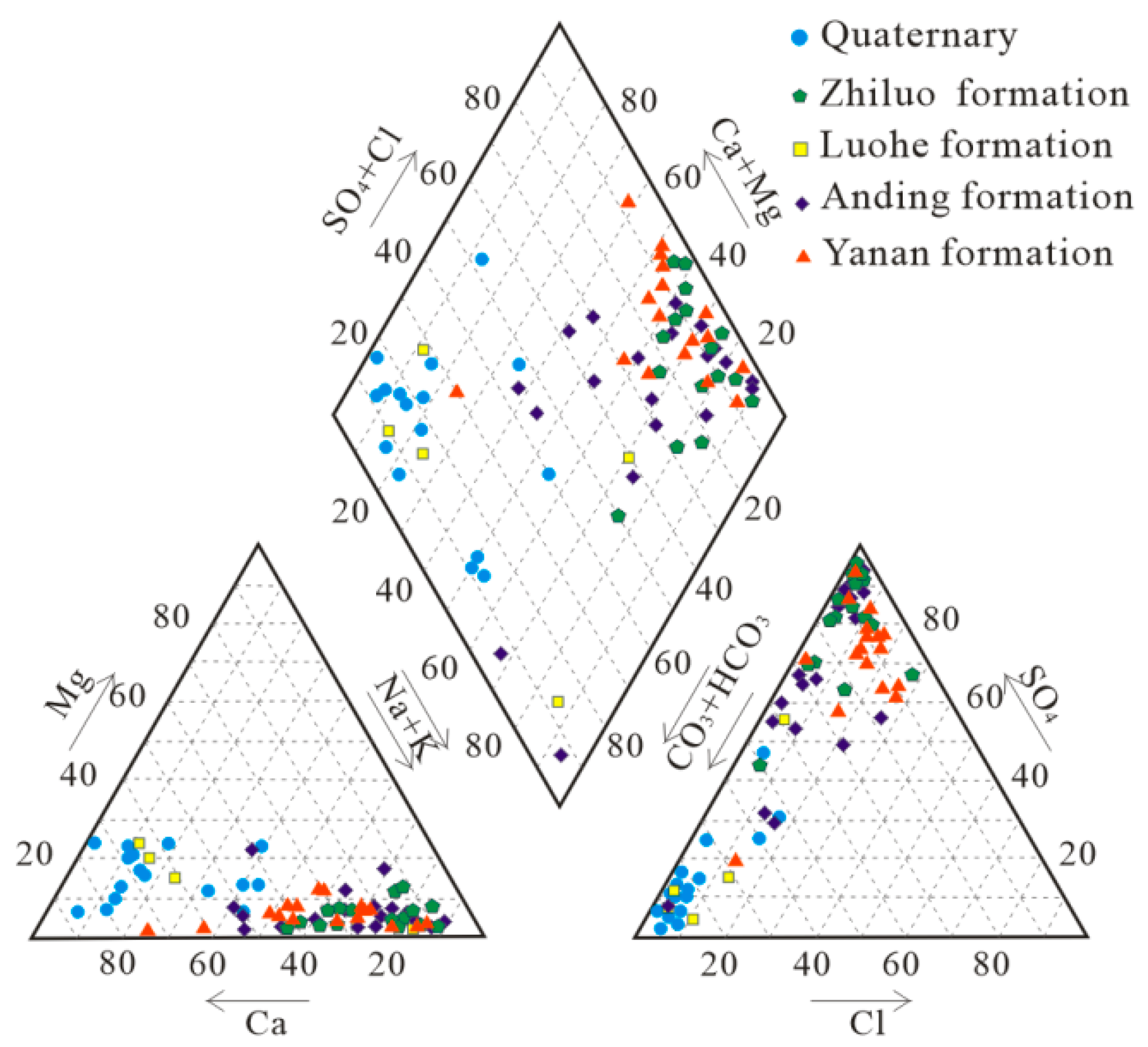
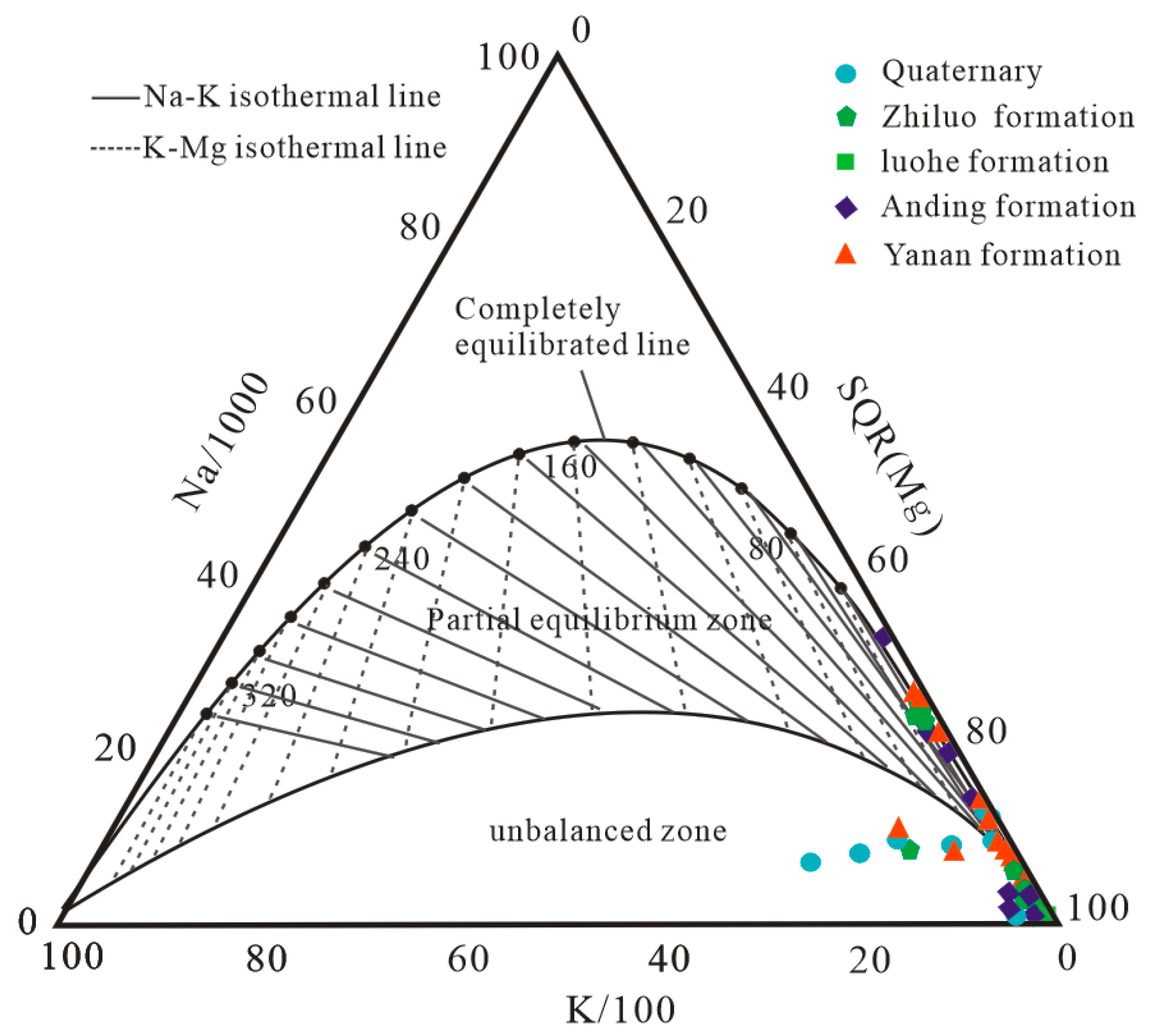
The mineralization degree (TDS) of the groundwater in the Yuheng mining area of northern Shaanxi increases from the Quaternary to Jurassic strata (1.23–36.20 g/L, with an average of 9.39 g/L), and the hydrochemical type gradually changes from HCO3-Ca type to SO4-Na type. The low sodium–calcium ratio and unsaturated salt mineral characteristics indicate that its hydrogeochemical evolution is in the immature to semi mature stage.
(2)
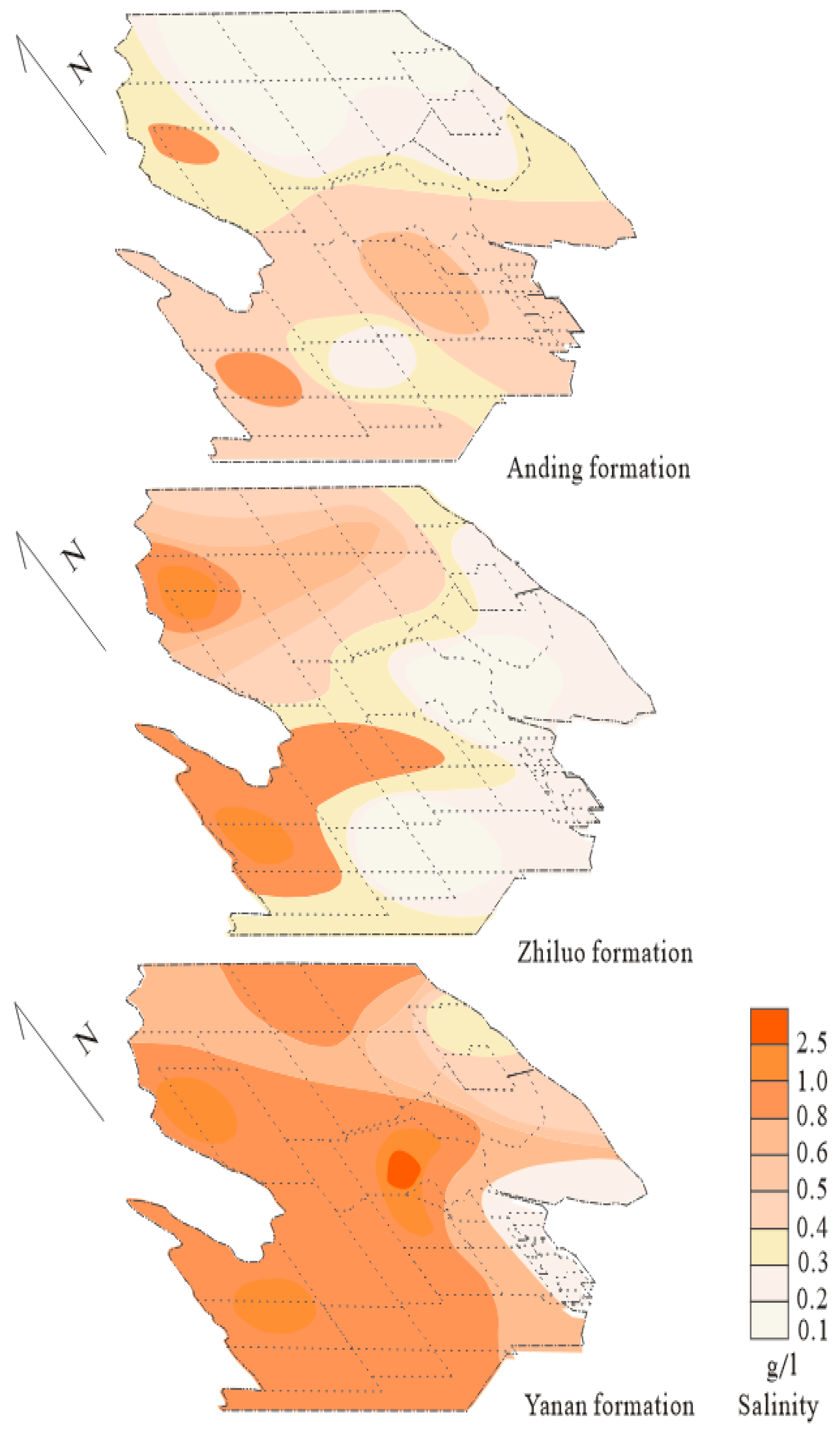
The highly mineralized groundwater in the Jurassic strata of the Yuheng mining area mainly exists in the Yan’an Formation, which is brackish water, saline water, and even saline water, gradually decreasing upwards. Some parts of the Zhiluo Formation and the Anding Formation area exhibit characteristics of brackish water. On the plane, the overall southwestern region is higher than the northeastern region, with the highest mineralization in the Hengshan-Boluo mining field and Weiqiang coal mining area in the central region. The Wusuhaize exploration area, Hongshiqiao-Weijiamao exploration area in the northwest, the Hongdunjie and Haizetan mining fields in the southwest have secondary high-value centers.
(3)
The highly mineralized water in the Yan’an Formation of the Yuheng Mining Area in northern Shaanxi comes from atmospheric precipitation, which is a mixture of sub modern water and recent water. The highly mineralized water is formed by the infiltration of atmospheric precipitation into the Jurassic strata and the leaching of sedimentary rock salt. Due to the strong sealing of the strata and the location in arid areas with insufficient recharge, the groundwater circulation alternates slowly, showing the characteristics of high mineralization. The distribution of water mineralization is controlled by the structure and primary sedimentation.

Author Contributions

Conceptualization, Y.H. and H.Z.; Methodology, Y.H. and H.Z.; Software, Y.H.; Validation, Y.W.; Formal analysis, L.Z.; Resources, Y.J.; Data curation, H.Z. Investigation, Y.H.; Writing—original draft Y.H; Writing—review & editing, H.Z. and Y.J.; Supervision, Y.W. All authors have read and agreed to the published version of the manuscript.

Funding

The project was financially supported by Natural Science Foundation of Shaanxi Province, China (2021JLM-14) and National Key Research and Development Program of China (2022YFC2904301).

Data Availability Statement

Dataset available on request from the authors.

Conflicts of Interest

Authors Hongchao Zhao and Yue Wang were employed by the company Shaanxi Coal and Chemical Technology Research Institute Co., Ltd. The remaining authors declare that the research was conducted in the absence of any commercial or financial relationships that could be construed as a potential conflict of interest.

References

  1. Dang, X.; Zhang, M.; Dong, Y. Research on protection and exploitation of groundwater resources in Northern Shaanxi Jurassic Coalfield. Front. Geol. 2010, 17, 200–207. [Google Scholar]
  2. Zhang, D.; Li, W.; Lai, X.; Fan, G.-W.; Liu, W.-Q. Development on basic theory of water protection during coal mining in northwest of China. China Coal Soc. 2017, 042, 36–43. [Google Scholar]
  3. Sun, K.; Fan, L.; Xia, Y.; Li, C.; Chen, J.; Wu, B.; Peng, J. Research on carrying capacity of geological environment based on the concept of water-preserved coal mining. J. China Coal Soc. 2019, 44, 830–839. [Google Scholar]
  4. Deng, N.; Yang, P.; Lin, P.; Li, F.; Lei, S.; Ma, F.; Zhou, Y.; Yuan, X. Study on zone chart of engineering geological conditions of protected water resources during coal mining in Yushen Mining Area. Coal Sci. Technol. 2017, 9, 167–174. [Google Scholar]
  5. Jin, D.; Wang, T.; Zhao, B.; Li, D.; Zhou, Z.; Shang, H. Distribution characteristics and formation mechanism of high salinity groundwater in northeast Ningdong Coalfield. Coal Geol. Explor. 2022, 50, 118–127. [Google Scholar]
  6. Ma, X.; Cheng, Z.; Cui, J.; Han, J.; Yin, C. Risk assessment of roof water inrush in No. 8 coal seam of Jurassic system Yan’an Formation in the first mining area of Xinzhuang Coal Mine in Ningzheng Mining Area. Coal Sci. Technol. 2023, 51 (Suppl. S1), 298–309. [Google Scholar]
  7. Dong, S.; Wang, H.; Huang, X.; Wang, H.; Cao, H.; Wang, X.; Zhang, Y.; Miao, H. Research on active water conservation technology in open-pit coal mine based on ecological protection groundwater level. Coal Sci. Technol. 2021, 49, 49–57. [Google Scholar]
  8. Sun, W.; Li, W.; Ning, D.; Ren, L. Current states, prediction and prevention suggestions for water hazard accidents in China’s coal mines. Coal Geol. Explor. 2023, 51, 185−194. [Google Scholar]
  9. Jin, D.; Liu, Q.; Wang, L.; Ding, X. Development and prospect of coal deposit hydrogeology. Coal Geol. Explor. 2009, 37, 28–31,36. [Google Scholar]
  10. Li, W.; Sun, H. Variation characteristics and cause of mine water quality in Malan coal mine. Coal Geol. Explor. 2013, 41, 46–49. [Google Scholar]
  11. Xiao, C. Hydrogeology; Geological Publishing House: Bath, UK, 2010. [Google Scholar]
  12. Ning, C.; Xing, M. Research on the law of watering and risk of Confined water-inrush From I5 Coal seam floor. Sci. Technol. Inf. 2012, 23, 400–401. [Google Scholar]
  13. Wu, J.; Wu, M.; Shen, J. Hydraulic Characteristics of limestone aquifer in Ji group coal floor and its impact to coal mine water filling in NO.12 Mine of Pingdingshan Coal mining group corporation. Zhongzhou Coal 2009, 10, 23–25. [Google Scholar]
  14. Hou, E.; Tong, R.; Wang, S.; Feng, J.; Chen, T. Prediction method for the water enrichment of weathered bedrock based on Fisher model in Northem Shaaxi Jurassic coal field. J. China Coal Soc. 2016, 41, 2312–2318. [Google Scholar]
  15. Zhao, C.; Jin, D.; Li, Z.; Shen, X.; Wang, H.; Wang, S.; Xu, F.; Wang, Q. Analysis of overlying aquifer water inrush above mining seam in Yushen mining area. J. China Coal Soc. 2021, 46, 523–533. [Google Scholar]
  16. Tarasenko, I.; Kholodov, A.; Zinkov, A.; Chekryzhov, I. Chemical composition of groundwater in abandoned coal mines: Evidence of hydrogeochemical evolution. Appl. Geochem. 2022, 137, 105210. [Google Scholar] [CrossRef]
  17. Fang, G.; Yang, J. Research on hydrogeochemical characteristics in Balasu well field of Yuheng mining area. Saf. Coal Mines 2019, 50, 56–62. [Google Scholar]
  18. Wang, S. Hydrogeochemical characteristics and forming reason of Ordovician limestone groundwater in Zhuoshan Coalfield. Coal Sci. Technol. 2022, 50, 180–188. [Google Scholar]
  19. Fan, L.; Ma, W.; Chang, B.; Sun, K.; Miao, Y.; Lu, B.; Tian, S.; Yang, L. Hydrochemical characteristics and formation mechanism of groundwater in Yushenfu Mining Area. Coal Sci. Technol. 2023, 51, 383–394. [Google Scholar]
  20. Li, W.; Gao, C.; Zhang, T.; Zhang, X. Analysis of hydrogeological characteristics and water filling conditions of Xiaojihan mine field in Yuheng mining area, northern Shaanxi. Geol. Shaanxi 2014, 32, 84–90. [Google Scholar]
  21. Ma, Z.; Li, J.; Zhai, M.; Wu, M.; Xu, Y. A comparative study of isotopic hydrogeochemistry of geothermal fluids of sedimentary basin type and volcanic type. Hydrogeol. Eng. Geol. 2019, 46, 9–18. [Google Scholar]
  22. Li, T.; Tan, H.; Fan, Q. Hydrochemical Characteristics and Origin Analysis of the Underground Brines in West Qaidam Basin. J. Salt Lake Res. 2006, 14, 26–32. [Google Scholar]
  23. Sun, H.; Wang, G.; Lin, W. Distribution characteristics and enrichment mechanism of TDS geothermal water in Xining Basin. Bull. Geol. Sci. Technol. 2022, 41, 278–287. [Google Scholar]
  24. Zhang, C.; Hou, X.; Li, X.; Wang, Z.; Gui, C.; Zuo, X. Hydrogeochemical characteristics and evolution mechanism of karst groundwater in the catchment area of the Sangu Spring. Hydrogeol. Eng. Geol. 2021, 48, 62–71. [Google Scholar]
  25. Cai, C.; Mei, B.; Li, W. Fliud migration and alteration: Constraints chemistry of Palaeozoic oil field water in central Tarim. Pet. Explor. Dev. 1997, 24, 18–22. [Google Scholar]
  26. Li, J.; Li, T.; Peng, X.; Han, Y.; Li, Z.; Ma, H. Hydrogeochemical behaviors of oil field water in the Tertiary in western Qaidarn Basin. Oil Gas Geol. 2014, 35, 50–55. [Google Scholar]
  27. Gibbs, R.J. Mechanisms controlling world water chemistry. Science 1970, 170, 1088–1091. [Google Scholar] [CrossRef]
  28. Gaillardet, J.; Dupré, B.; Louvat, P.; Allegre, C.J. Global silicate weathering and CO2 consumption rates deduced from the chemistry of large rivers. Chem. Geol. 1999, 159, 3–31. [Google Scholar] [CrossRef]
  29. Cllark, I.C.; Peter, F. Environmental Isotopes in Hydrogeology; Lewis Publishers: New York, NY, USA, 1997. [Google Scholar]
  30. Wang, S.; Zhang, Y. The formation and evolution of Ordos Basin and the law of coal accumulation. Front. Geol. 1999, 6, 147–155. [Google Scholar]
  31. Wang, D.; Shao, L.; Li, Z. Palaeogeographic characteristics of the Middle Jurassic Yan an Age in northern Shaanxi Province. J. Palaeogeogr. 2012, 14, 451–460. [Google Scholar]
  32. Wang, H.; Ma, L. Study on sediment environment and rock mechanics characteristics of the delta plain of Jurassic coalfield in northern Shaanxi. Coal Geol. Explor. 2019, 47, 61–69. [Google Scholar]
  33. Ma, L. Study on distribution characteristics and sedimentary genesis of sulfur in coal taking southern Yuheng Mining Area of Ordos Basin as a case. Coal Sci. Technol. 2020, 48, 200–209. [Google Scholar]
Figure 1. Location and regional geological structure (a,b) of Yuheng mining area.
Water 17 01459 g001
Figure 2. Salinity concentration distribution of the ground water of Jurassic strata in Yuheng mining area.
Water 17 01459 g002
Figure 3. Piper diagram of the ground water of Jurassic strata in the Yuheng mining area.
Water 17 01459 g003
Figure 4. Na-K-Mg triangular diagram of the ground water of Jurassic strata in the Yuheng mining area.
Water 17 01459 g004
Figure 5. Relationship of chemical ion coefficients in Yan’an Formation of Yuheng mining area, in northern Shaanxi.
Water 17 01459 g005
Figure 6. Gibbs diagram of Yan’an Formation in Yuheng mining area (a,b), in northern Shaanxi.
Water 17 01459 g006
Figure 7. Diagrams of the relationships between Ca2+/Na+ and Mg2+/Na+, Ca2+/Na+ and HCO3/Na+of ground water in Yan’an Formation of Yuheng mining area (a,b), in northern Shaanxi.
Water 17 01459 g007
Figure 8. δD-δ18O plot showing the stable isotope composition of geothermal waters in Yuheng mining area.
Water 17 01459 g008
Figure 9. Sedimentary facies map of the Yan’an Formation in the Jurassic coalfield of the Yuheng mining area (I. Early sedimentation of Yan’an Formation; II. Mid stage sedimentation of Yan’an Formation; III. Late middle stage sedimentation of Yan’an Formation).
Water 17 01459 g009
Table 1. Stratigraphic system of Yuheng mining area.
Stratigraphic SystemThickness
/m
LithologyGroundwater TypeAquifer GroupDistribution Area
BoundaryLineSeriesSet
NeozoicQuaternaryQ4 0~30Alluvial sand gravel layer and aeolian sandy landLoose
rocks
pores
fissure
diving
Valley alluvium divingRiver Valley Terrace Area
Q3Malan0~50Loose silty clayPore diving in alluvial lacustrine depositsDesert beach area
Sarawusu0~107Silty sandy loam, sub-clay
Q2Liushi0~220Sandy clay thin sub-clayLoess fissure pore divingHuangtuliangmao District
Q1Wucheng0~36Silty clay containing calcareous concretion/Poor water richness/
NeoproterozoicN2Jingle0~100Layered sandy clay, with calcareous concretion layer/Poor water richness/
MesozoicCretaceousK1Luohe0~340Coarse grained sandstone, gluteniteDebris
rocks
fissure
pores
diving
and layer
Sandstone fissure, pore divingGenerally distributive
JurassicJ2Anding0~170Sandy mudstone, fine sandstone, local coarse conglomerateFissure diving in bedrock weathering zoneFissure diving is developed in bedrock weathering zone, confined water is widely distributed below the weathering zone, and fissure diving is developed in burnt rock area
Zhiluo0~250Coarse or medium coarse sandstone, fine sandstone, siltstone, silty mudstoneInterlayer confined water
Yan’an103~395Coarse grained sandstone, fine sandstone, siltstone, silty mudstone, mudstone, carbonaceous mudstone, coal seamInterlayer confined water; burnt rock fissure diving
J1Fu county0~130Medium-thick sandstone, sandy mudstone, black thin carbonaceous mudstoneInterlayer confined water
TriassicT3Wayaobao0~450Sandstone, siltstone, mudstone, mudstone with coal lineInterlayer confined water; burnt rock fissure diving
Table 2. Statistics on groundwater mineralization of each coal mine in Yuheng mining area.
Coal Mine or Mine FieldAquifer formationSample
Size
Mineralization
g/L
Coal Mine or Mine FieldAquifer formationSample
size
Mineralization
g/L
DahaizeQuaternary 10.26YuandatanQuaternary 30.23~0.66
Luohe 10.39Luohe 10.65
Anding 10.83Anding 20.97~1.49
Zhiluo 15.13Zhiluo 22.47~4.21
Yan’an 34.97~5.27Yan’an 43.82~5.72
BalasuQuaternary 10.27WusuhaizeQuaternary 20.33~0.46
Luohe 10.35Luohe 20.37~0.74
Anding 20.47~0.50Anding 19.12
Zhiluo 14.58Zhiluo 25.13~10.30
Yan’an 24.24~6.15Yan’an 25.840~10.97
HongshixiaQuaternary 20.25~317.00HuanghaojieQuaternary 10.23
Anding 10.370Anding 10.38
Zhiluo 11.28Zhiluo 10.78
Yan’an 23.59~3.70Yan’an 36.42~9.58
XiaojihanQuaternary 10.22Hengshan-
Boluo
Quaternary 10.33
Luohe 10.32Anding 10.55
Anding 10.48Zhiluo 20.55~0.70
Yan’an 27.68~9.48Yan’an 26.35~36.25
ZhaoshipanQuaternary10.22ShiliutaiQuaternary 30.17~0.25
Anding 22.36~2.93Anding 20.86~1.49
Zhiluo 10.52Zhiluo 10.47
Yan’an 19.10Yan’an 14.56
HaizetanAnding 19.38LuheAnding 15.84
Zhiluo 110.36Zhiluo 15.97
Yan’an 27.41~10.85Yan’an 34.76~9.99
LeilongwanAnding 22.69~4.67TawanAnding 22.68~3.20
Zhiluo 17.62Zhiluo 10.33
Yan’an 23.63~8.88Yan’an 25.32~9.55
Hongshiqiao
-Weijiamao
Anding 22.63~9.13WeiqiangAnding 21.25~5.84
Zhiluo 23.11~4.06Zhiluo 34.67~8.69
Yan’an 26.48~8.97Yan’an 44.87~10.53
FanjiaheQuaternary 10.14KekegaiZhiluo 16.83
Zhiluo 10.97
Yan’an 21.04~1.23
Table 3. Tritium age division of groundwater in continental areas and tritium values in target areas.
Age Experience DivisionTritium Value in Target Area
Tritium Test RangeAge DomainMine Fields/Coal MinesLayerSample
Size
Tritium Test RangeData Sources
<0.8 TUSub-Modern Water, recharged before 1652YuandatanQuaternary System217.8~26.2 TUTests in this article
Yan’an Formation31.7~5.7 TU
0.8 TU~4 TUSub-modern water and recently supplied mixed waterWeiqiangLuohe Formation225.2~26.1 TU
Yan’an Formation52.1~15.6 TU
5~15 TUModern water (<5~10 years )XiaojihanQuaternary System317.1~27.2 TU
15~30 TUGroundwater containing some nuclear explosion tritiumYan’an Formation33.8~5.3 TU
>30 TUContaining a considerable amount of the water supply from the 1960s
or the water supply from the 1970s
BalasuQuaternary System/11.6~27.9 TUDr. Fang Gang [17]
Luohe Formation/1.0~1.9 TU
>50 TUMainly the water supply from the 1960sYan’an Formation/1.0~2.1 TU
Table 4. Compositions and contents of sediment minerals of halite in coal seam of Yuheng mining area in northern Shaanxi.
Sample
Number
Mineral Composition/%
GypsumClay MineralSiderite PyriteAnhydrite
YDT-0180.866.55.61.1
YDT-0287.63.84.73.90
YDT-0386.40.33.56.73.1
WQ-0185.75.34.73.50.8
WQ-0286.34.13.26.40
average value85.43.94.55.21
Disclaimer/Publisher’s Note: The statements, opinions and data contained in all publications are solely those of the individual author(s) and contributor(s) and not of MDPI and/or the editor(s). MDPI and/or the editor(s) disclaim responsibility for any injury to people or property resulting from any ideas, methods, instructions or products referred to in the content.

