Article

Water Demand Determination for Landscape Using WUCOLS and LIMP Mathematical Models

1
Alamoudi Water Research Chair, King Saud University, P.O. Box 2460, Riyadh 11451, Saudi Arabia
2
Department of Agricultural Engineering, College of Food & Agriculture Sciences, King Saud University, P.O. Box 2460, Riyadh 11451, Saudi Arabia
*
Authors to whom correspondence should be addressed.
Water 2025, 17(10), 1429; https://doi.org/10.3390/w17101429
Submission received: 12 March 2025 / Revised: 29 April 2025 / Accepted: 8 May 2025 / Published: 9 May 2025

Abstract

:
The conflicts among the landscape water demand and other urban water requirements are motivating improvements in water sustainability in arid urban areas. The accurate estimation of urban landscape plants’ evapotranspiration (ETPLT) is crucial for effective irrigation management practices. This study examined two factor-based approaches—the Water Use Classification of Landscape Species (WUCOLS) and the Landscape Irrigation Management Program (LIMP)—in conjunction with the formula developed by Penman–Monteith to calculate the landscape irrigation water demand in Saudi Arabia. The reference evapotranspiration (ETr) was calculated utilizing 40 years of recorded meteorological data from various locations in Saudi Arabia. Notable variations in ETr were observed both geographically between different regions and seasonally within regions. The highest, lowest, and moderate ETr values were recorded in Riyadh, Mecca, and Asir, measuring 9.5, 6.7, and 5.3 mm, respectively. Regarding the decoupling approaches, the moderate species factor (Ks) of WUCOLS was compared to the three levels of managed stress (Ksm) in LIMP, categorized as “low, moderate, and high”. The statistical analysis revealed a significant advantage of Ks moderate over Ksm low, with a 37.5% reduction in the average ETPLT. Although no significant differences were observed between moderate Ks and Ksm, the ETPLT derived from WUCOLS was 16.7% lower than that from LIMP. Conversely, the advantage shifted towards Ksm high, which demonstrated a 20% decrease in the ETPLT estimates. These results support the Saudi Green Initiative by furnishing essential data for sustainable water management in arid regions, promoting a science-driven approach to enhance water use efficiency and alleviate water scarcity.

1. Introduction

Water is the basis of life, being generally accepted as a fundamental component [1]. This highlights a major issue facing the planet nowadays: guaranteeing the availability of safe and clean water. Several factors determine the water issue: population increases, climate change, and unsustainable water consumption resulting from certain policies [2]. Estimates from the United Nations’ Department of Water Administration indicate that worldwide water stress—defined as the ratio of water taken for industrial, agricultural, and household usage to the available water—was at a reasonable level of 18.2% in 2020 [3]. On the other hand, by 2022, 2.4 billion people lived in places where certain events caused significant water stress. Moreover, 51 of the 164 examined nations and territories are expected by the World Resources Institute (WRI) to have high to very high degrees of water stress by 2025. This amounts to 31% of the world’s population overall [4].
For instance, the West Asia and North Africa (WANA) region, characterized by extensive arid landscapes, is experiencing a notable decline in both cultivable land and agricultural biodiversity. The primary factors contributing to this deterioration include overgrazing, deforestation, unsustainable agricultural practices, and industrial activities, as noted by El Kharraz and El-Sadek [5]. A major issue for WANA countries is the severe scarcity of freshwater resources. The annual per capita renewable water supply in this region is approximately 1500 cubic meters, significantly lower than the global average of over 7000 cubic meters [6]. By 2025, the per capita water availability is expected to fall below 700 cubic meters, placing considerable strain on water security and sustainable development [7,8].
Regarding the regional level, the previously mentioned problems and challenges also apply to the Kingdom of Saudi Arabia (KSA). Saudi Arabia is one of the warmest desert countries on Earth [9]. Hence, it is a prime example of the relentless effects of natural aridity [10]. Saudi Arabia’s agricultural industry is marked by the notable depletion of groundwater supplies out of necessity due to the extreme conditions in this arid region [11]. This change in water sourcing policies was implemented to meet the immediate demands of agriculture but has resulted in a concerning reality: the partial depletion of groundwater, which is the main source of freshwater in the area. Furthermore, this is not a renewable resource [12]. The index on groundwater shortages classifies Saudi Arabia as a very high-risk region, thereby supporting this assertion [13]. The World Resources Institute (WRI) forecasts show that the whole Arabian Peninsula lies under the very high sector, expected to use at least 80 percent of the accessible water by 2050 [4].
Notwithstanding these severe conditions, the Kingdom of Saudi Arabia is working to raise urban citizens’ quality of living. The Saudi Green Initiative is a major project in progress in the Kingdom of Saudi Arabia [14]. This project seeks to create several parks and gardens, as well as planting ten billion trees [15]. In these cases, irrigation experts are rather important, since their knowledge is necessary to reach the project’s goals and guarantee the sustainability of water supplies. Sustainable water development’s main goal is to encourage efficient water management methods, making conservation and pollution control the first priority [2]. This means using technology and methods for water reuse [16], recycling [17], and rainwater collection [18]. In addition to refining irrigation management practices to maximize irrigation water consumption [19], sustainable water development’s main objective is to meet the growing water demand of the world’s population while maintaining the limited water resources, in turn guaranteeing that the needs of the next generations are not compromised [2]. This directly marks Earth Overshoot Day, which is the moment in the calendar year when the human utilization of natural resources and ecosystem services exceeds the Earth’s ability to replenish these resources within the same year [20].
While determining the precise amount of water needed for landscape plants to maintain their quality, landscaping managers should take into account reducing losses from deep percolation or runoff onto impermeable surfaces. Three plans have been suggested by Snyder and Pedras [21] to eliminate these losses and achieve the optimal situation. These measures are maximizing the distribution uniformity (DU), avoiding runoff through appropriate application rates and durations, and applying the appropriate quantity of water to satisfy plants’ needs. They mostly seek to guarantee sufficient water application to satisfy the needs of plants, and estimating the precise volume of water lost by soil evaporation and plant transpiration helps to achieve this goal. Urban environments provide more complex estimates of evapotranspiration (ET) than rural environments because of the greater variety of plant species, the prevalence of small, isolated green areas, and the numerous microclimates [22]. Choosing the suggested drought-resistant plants might not ensure the expected water savings. This results from homeowners and landscape designers sometimes being unaware of their plants’ water needs [23].
Knowing the water requirements of plants represents a tremendous challenge in the complicated field of environmental management. Various plant species have somewhat varying water needs. Although certain species are more likely to thrive with minimal moisture, others require a great deal of water, even in the middle of summer. This variability highlights the challenge of satisfying the water needs of landscape vegetation [19,24]. The interplay among irrigation techniques and plant physiology hinders the discovery of optimal watering strategies. Drought-resistant species [25] could be irrigated for several purposes: to ensure survival, to protect esthetic qualities by controlled development, or to encourage robust vegetative expansion. Every aim requires a tailored watering schedule suited for the specific physiological and ecological features of the involved plants [26]. Allen and Dukes [27] claim that, given the great volume of water consumed in residential and urban settings and the great value of the water used, the demands and utilization of these environments have become major factors. Water resources are limited [28]; hence, it is necessary to maximize their use while preserving the health of landscape plants. To provide a scientific resolution to this complex problem, the evapotranspiration of landscape plants (ETPLT) may be quantified, mostly with a decoupled landscape coefficient approach.
The ultimate goal of the current work is to investigate the effectiveness of the WUCOLS [23] and LIMP [21] approaches in conjunction with the Penman–Monteith (PM) formula [19] to revolutionize the knowledge of landscape plants’ essential water requirements by providing a scientific basis for sustainable water resource management. The present investigation seeks to achieve this goal by obtaining precise estimates of the evapotranspiration (ETPLT) of landscape vegetation. It is difficult to identify an appropriate crop coefficient for various topographies; this complexity undoubtedly influences water demand estimation [29]. The use of the WUCOLS and LIMP models is expected to fill this gap and contribute to rationalizing water consumption in arid regions—specifically in KSA, where freshwater scarcity is a major concern.
Given the abovementioned difficulties, this study aims to investigate how much the WUCOLS and LIMP methods differ in estimating landscape water needs in arid regions—specifically in Saudi Arabia—and which one produces superior results. The answer to this question provides a sensible framework to maximize and reduce irrigation water consumption. Specifically, the investigation relies on four decades of real meteorological data, which serve as the foundation for the calculation of ETr. Furthermore, this work applies the results to real-world scenarios. Scholars, city designers, developers, and legislators will find immense value in this strategy. Hence, this study will provide the impetus to initiate a new phase of sustainable water resource management in particularly dry areas, offering a scientific basis for sustainable water resource management, thereby benefiting society, the economy, and the environment. The results will give decision-makers an overall picture before initiating programs based on afforestation and landscaping. This will help them to decide on suitable architectural designs and ideal irrigation water volumes. This creative research could change the water needs of landscape plants, provide a strong solution to the complex problems in this field, and enable stakeholders to make wise judgments and apply sustainable water management techniques.

2. Materials and Methods

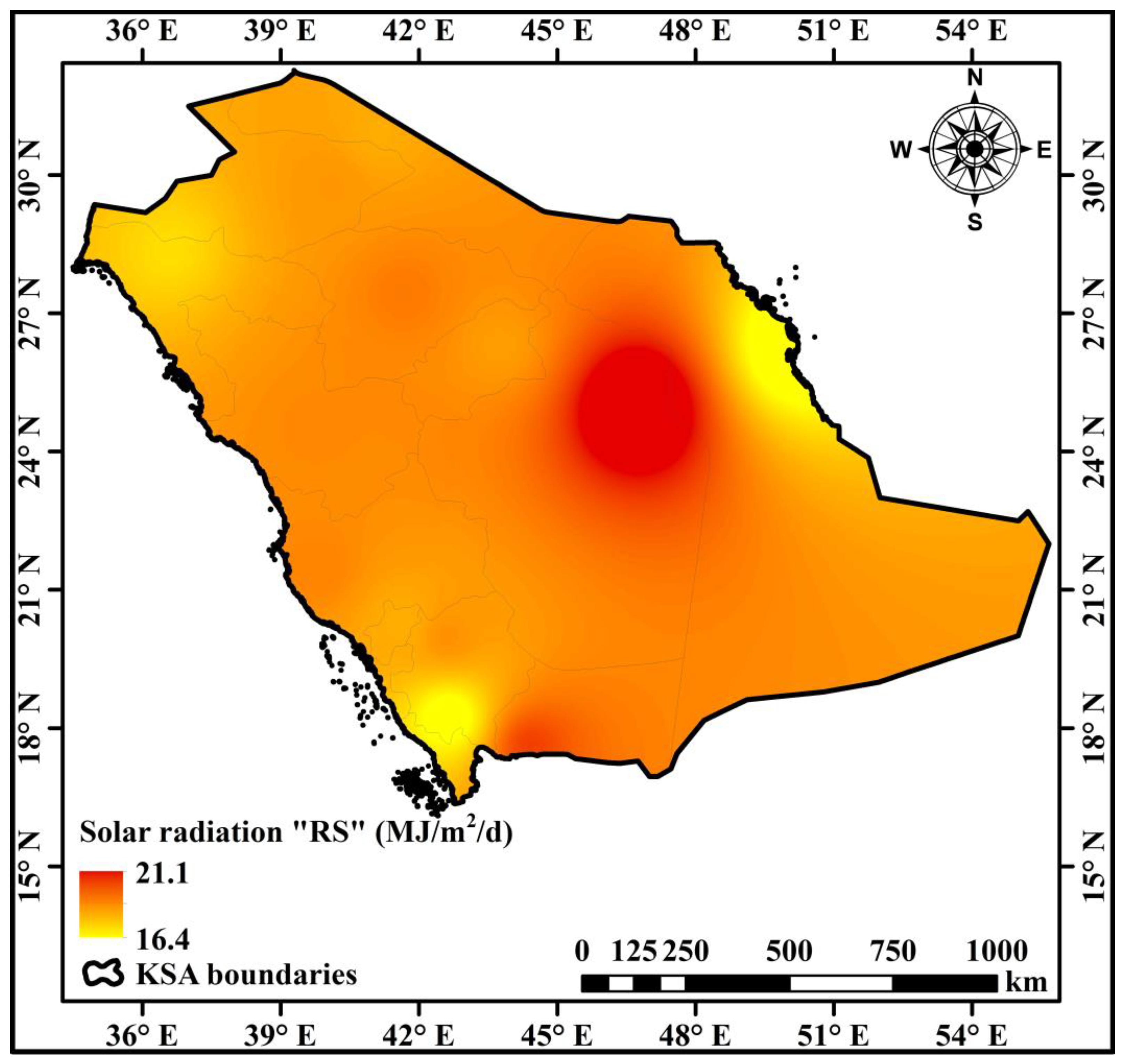
2.1. Study Area Description

Comprising around 2.25 million km2 (Figure 1), the Kingdom of Saudi Arabia (KSA) is among the largest nations in Asia. KSA is the largest nation in the Arabian Peninsula, with about 75% of the land area [18]. Over its vast area, the terrain shows notable variety. With 13 administrative areas, Saudi Arabia boasts unique features like a varied size, population density, climate, and soil types. Saudi Arabia has a varied geography, ranging from hilly regions to coastal plains near its borders to a large central desert [30]. KSA stretches roughly 2100 km from north to south and 2000 km from east to west [31]. The topography and geology of the Arabian Peninsula are distinctive, with the well-known geological structure, the Arabian Shield [32]. The Red Sea defines the western peninsula shore. Comprising much of the southern peninsula, the 650,000 km2 Rub’ al Khali—also known as the Empty Quarter—is regarded as the largest contiguous sand desert in the world. It includes the land of Saudi Arabia, Oman, the United Arab Emirates, and Yemen. With some reaching 250 m, the shifting Rub’ al Khali dunes reflect geological occurrences from ancient times. With its high temperatures and scant rainfall, the severe environment of the desert makes it essentially uninhabitable and underdeveloped.
This vast study area corresponds to the Köppen–Geiger classification of a hot arid desert climate (BWh), distinguished by colder, more humid winters and extreme, dry summers [18]. The temperatures dip between 14 °C and 24 °C in the winter months, i.e., December through February; during the prime summer months of June through August, they typically range from 43 °C to 54 °C. With around 8.2 million people and an annual growth rate of 2.7% [33], Riyadh, the capital, reflects the fast urbanization and development of the country. Ranked among the fastest-growing metropolises globally, Riyadh boasts a range of public and private properties, as well as extensive infrastructure, including roads, airports, bridges, rivers, and highways. Saudi Arabia’s critical water resources justify its relevance as a case study. In this arid area, desalinated water, some renewable aquifers, and non-renewable groundwater from deep wells constitute the major water supplies [34]. Saudi Arabia is a suitable case study for an analysis of the balance between the water supply and demand in dry areas because of the unique interaction among geographical, climatic, and demographic elements [19].

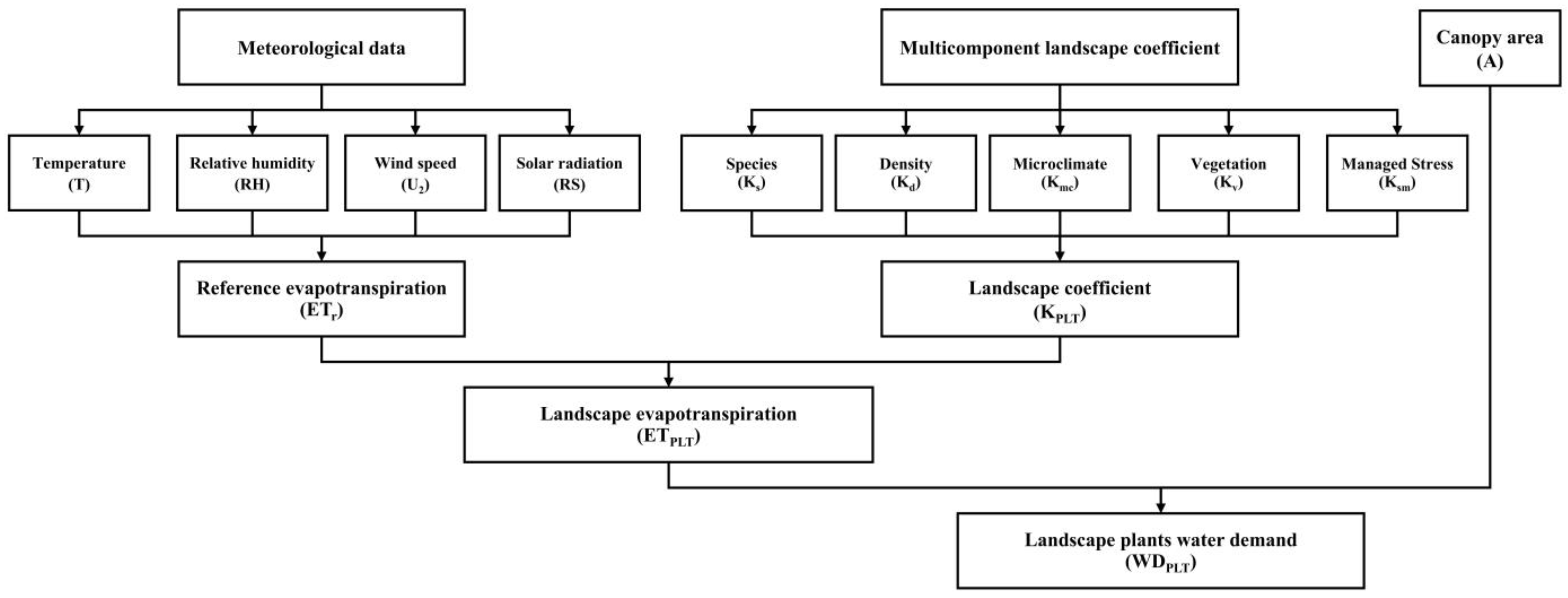
2.2. Decoupled Landscape Coefficient (KPLT) Approaches

Two main factors define both agricultural and landscape systems. Because of the variety of plant types and species, as well as the erratic spatial layouts, quantifying the evapotranspiration (ET) in landscape systems becomes difficult. Secondly, although the major goal of agricultural irrigation systems is to maximize the biomass output [27], the main reason for landscape irrigation is typically to improve the esthetic appeal of the landscape. The water needs of several landscape plants were assessed in this work using two methods. The first was the Water Use Classification of Landscape Species (WUCOLS) produced by Costello [23]. The second was the Landscape Irrigation Management Program (LIMP) defined by Snyder and Pedras [21]. Figure 2 shows the methodological flowchart applied in determining the water requirements of landscape vegetation.
The calculations were based on the following guiding equation:
E T P L T = K P L T × E T r
where ETPLT represents the landscape evapotranspiration (mm/d), ETr stands for the reference evapotranspiration (mm/d), and, finally, (KPLT) is the multicomponent landscape coefficient, a dimensionless coefficient developed to provide a dependable estimation of ETPLT.
Landscape coefficients are utilized to measure the water necessary to sustain a landscape in an esthetically pleasing or functionally adequate state. The landscape coefficient serves as an alternative method of assessing water loss in a region, quantifying the water required to maintain the landscape quality.

2.2.1. WUCOLS Approach

Measuring ET in composite plantings is difficult given the interactions in the environment and the variety of plant species found there. The density of plants across different environments shows notable change. Young landscapes have a smaller leaf area than mature ones, which reduces their capacity to absorb radiation. Adult landscapes usually show higher transpiration rates than their younger equivalents. The sunlight absorption of a landscape with trees surrounded by ground cover or shrubs surpasses the water demand for trees that are mulched over. Microclimates may arise in a variety of settings, from hot, sunny, or windy locales to shaded or sheltered areas. These variations are reflected in crop coefficients [35] and affect ET in ways that do not align with the homogeneous appearances of large areas of vegetation.
For a landscape, the evapotranspiration (ET) depends on the species grown, the density of the vegetation, and the microclimate conditions. One may determine the landscape coefficient as follows:
K P L T = K S × K d × K m c
where Ks, known as the species factor, considers differences in the species-specific water needs stated as a fraction of the reference evapotranspiration (ETr). The water use in mixed-species landscapes varies among groundcover, shrub, and tree species. Costello [23] offers information about several particular plant species to build a complete species factor for the landscape.
By acknowledging that the water loss from dense plantings is probably greater than that from sparse ones, the density factor, or Kd, clarifies the variations in vegetation density among landscape plants. It entails computing, for a given amount of land, the ground cover percentage. The assigned Kd values depend on the degree of vegetation and canopy cover. When the canopy cover falls between 70% and 100%, monoculture plantings—including trees—show a small Kd value. In cases with mixed plant types, where one type is dominant, Kd is given depending on the canopy cover of the dominant vegetation. Low Kd values usually indicate canopy coverage below 70%; for shrubs and groundcover, it is below 90% [23]. For trees, this also applies. On the other hand, plants showing complete canopy cover (100%) have higher Kd values, which is especially important in the Kingdom of Saudi Arabia, considering the variety of vegetation. Studies on agricultural orchards highlight these needs, such as the work of Waller and Yitayew [26].
Kmc, which is the microclimate factor, pertains to microclimatic conditions that are prevalent in urban environments. Urban elements, including buildings, structures, and asphalt, substantially affect the foliar and air temperatures, wind patterns, and humidity levels. If the landscape resembles ETr conditions (open region), Kmc is established at 1.0. For plants situated in shady or wind-sheltered locations, the Kmc values vary from 0.5 to 0.9. A quantitative method for the determination of microclimatic parameters is absent [23,26]. Table 1 presents a comprehensive breakdown of these parameters [14,19,23].

2.2.2. LIMP Approach

A comparable yet more quantitative method of estimating the formulated KPLT has been proposed, which utilizes different ranges for the KPLT components compared to those used by Costello [23]. Snyder and Eching [36] have modified the WUCOLS procedure to obtain the Landscape Irrigation Management Program (LIMP).
In LIMP, ETPLT is calculated using the following equation:
E T P L T = K P L T × E T r
considering
K P L T = K v × K d × K m c × K s m
by substituting Equation (3) with
E T P L T = ( E T r × K m c ) × K v × K d × K s m
we obtain
E T P L T = E T r l × K v × K d × K s m
The local reference evapotranspiration (ETrl) represents the estimated ETr for the local climate, assuming that weather data can be collected over a well-irrigated grass surface to determine the ETr specifically for this climate.
Kv (vegetation factor) is calculated as
K v = E T v E T r
where ETv represents the evapotranspiration of well-irrigated vegetation with over 70% ground shading. It is roughly analogous to a well-watered crop coefficient in agricultural contexts. Although the literature on Kv values is limited, some estimates can be obtained using the WUCOLS approach [23]. In WUCOLS, the Ks values should be similar to Kv for vegetation that is generally well-watered [21].
The only categorized estimation for Kv was proposed by G. Allen and L. Wright [37], who assigned a range of 0.7–1.2 for general species types (Table 2) under a high density and a full water supply [22]. The value of Kv can exceed 1 when landscape plants are taller and rougher than the standard 0.12 m reference grass [27]. It is assumed that plant physiological changes are not significant throughout the year, so a single value could be used for Kv all year round [38]. For the current work, since ETv had not been measured, we could not estimate Kv in situ; therefore, we used the Kv values proposed by G. Allen and L. Wright [37].
Kd (density factor): In LIMP, the Kd coefficient signifies the ratio of the ET of vegetation with less than 70% ground shading to that of vegetation with 70% or more ground shading. The density coefficient in LIMP is estimated using the following equation [39]:
K d = sin π C g 140
where Cg represents the percentage of ground shaded by green vegetation, when this value is below 70%. It is assumed that, once the midday shading surpasses 70%, most solar radiation is intercepted by vegetation, leaving no additional energy for evaporation in canopies with more than 70% shading. Therefore, Kd equals sin π / 2 = 1 [21,22,38].
Kmc (microclimate factor): The microclimate coefficient is used to adjust the ET from reference surfaces to reflect the local microclimatic conditions. Urban environments often create unique microclimates that can lead to varying irrigation needs across the landscape. In LIMP, microclimates are addressed by comparing the regional ETr with a standardized reference ET (ETrl), representing the expected standardized reference ET in the local microclimate. The microclimate factor (Kmc) is then calculated as
K m c = E T r l E T r
Regional climate data are generally supplied by a regional or statewide automated weather station network to estimate ETr. The weather station site is usually chosen to ensure that the data accurately represent the region. Local microclimate data, either estimated or measured, are used to determine ETrl using the same standardized reference ET equations applied for the regional ETr. In the absence of a weather station onsite or in the case of difficulties in obtaining such data, G. Allen and L. Wright [37] have proposed reliable guideline values for Kmc assignment (Table 2).
Ksm (managed stress factor): The managed stress coefficient (Ksm) is the ratio of the ET of stressed vegetation to that of non-stressed vegetation. Therefore,
K s m = E T s m E T v
It is a deliberately managed stress factor that can be estimated through the experience and observations of local horticulturists [27]. In LIMP, the Ksm coefficient is an empirical coefficient that is equal to the mean ratio [21]. It was categorized for general landscape plant types by G. Allen and L. Wright [37] into three levels of high, average, and low stress, as mentioned in Table 2. During this study, the values of Ksm were assumed based on the values proposed by G. Allen and L. Wright [37].

2.3. Reference Evapotranspiration (ETr) Estimation

Determining irrigation plans and the volumes of water needed for efficient soil penetration [40] depends considerably on the rate of water consumption by plants. The lack of accurate knowledge of plants’ water use makes effective irrigation system management somewhat difficult [35]. Various mathematical models have been created in the domains of environmental science and agriculture to measure the reference evapotranspiration (ETr), a vital statistic in evaluating water demands in crops [41]. Among these models, the Penman–Monteith equation has become somewhat popular as it can provide approximations that strongly match recorded observations. Many studies have evaluated several ETr equations; a study by Howell and Steiner [42] provides a clear example. Under the conditions studied, their comparison of many ETr models for full-cover, well-watered sorghum and winter wheat highlighted the Penman–Monteith model as offering the most accurate projections. Later studies by Allen and Jensen [43] and Allen and Pereira [44] have confirmed the Penman–Monteith approach’s dependability and positioned it as the recommended technique in computing the reference crop water usage.
This study used the Penman–Monteith model as its main analytical instrument, given the strong empirical evidence and the general agreement among scholars on its effectiveness. This model is especially useful in producing consistent ETr estimations as it can capture the intricate interactions among climatic factors and crop water needs. By using the Penman–Monteith equation, this study conforms to the present best practices in the area, and it enables significant comparisons with other studies using this widely accepted approach.
This work builds upon the Penman–Monteith model by using the improved formula presented by Ezzeldin and Alazba [19], enhancing its applicability for different plant heights. Essential to our computational approach, the updated equation is given in Equation (11). We used a reference plant height of 15 cm to ensure consistency in our study.
E T r = λ 1 Δ Δ + γ * R n G + γ Δ + γ * K e s e a
ETr stands for the reference evapotranspiration (mm/d) in this formulation; λ is the latent heat of vaporization (MJ/kg); the slope of the saturation vapor pressure–temperature curve (in kPa/°C) is indicated by the variable ∆; and γ* is the adjusted psychrometric constant (kPa/°C). Moreover, Rn represents the net radiation computed at the crop surface (MJ/m2/d); G relates to the soil heat flux density at the surface (MJ/m2/d); the psychrometric constant is γ (kPa/°C); and K is determined by the formula 1.854 × 1 0 5 × λ / r a T + 273 (MJ/m2/d/kPa). Additionally, es represents the saturation vapor pressure (kPa); ea is the mean real vapor pressure (kPa); T represents the air temperature (°C); and ra denotes the aerodynamic resistance (s/m).
Particularly in dry settings, this equation helps to estimate the reference evapotranspiration, which is a vital statistic in measuring the water demand in landscape plants. Using this scientifically strong formula, the current work aimed to clarify the intricate dynamics of water use, thereby providing the basis for future discoveries and insights [19].

2.4. Water Depth Demand Estimation (WDD)

This study focused on estimating the daily landscape water depth demand (WDD), an important metric in assessing water consumption in landscape plants. WDD was calculated using Equation (12), as outlined by Waller and Yitayew [26]:
W D D = E T P L T W A E × ( 1 L R )
In this context, ETPLT stands for the landscape evapotranspiration (mm); WAE indicates the water application efficiency, an essential component of water management; and LR refers to the leaching requirement, which influences the overall water usage. This study sought to estimate the optimal WDD (mm/d). For this estimation, this research assumed the water application efficiency (WAE) to be 100% and the leaching requirement (LR) to be 0%. These assumptions established a foundation for the analysis of the daily landscape water depth demand under specific conditions.

2.5. Data Source

The meteorological data utilized for the current work were obtained from the National Center for Meteorology of Saudi Arabia, which manages the official weather stations. These data included the temperature, relative humidity, solar radiation, and wind speed. It is noteworthy that the data comprised measured historical data covering 4 decades—specifically, from 1980 to 2021. This huge dataset was systematically collected, organized, and meticulously prepared for subsequent calculations. The dataset encompassed meteorological information across the 13 regions of KSA. Across this extensive time period, the analysis computed the monthly average daily data for each region. This extensive collection of measured data, as opposed to re-analyzed outputs from models, served as the basis of this study and was employed to derive significant and applicable conclusions regarding the landscape irrigation water demand in arid climates.

2.6. Statistical Analysis Between WUCOLS and LIMP

To comprehend the significant differences between the ETPLT values estimated by the decoupling approaches, the independent-sample T-test [45] was used with respect to WUCOLS (moderate Ks) and LIMP (low, moderate, and high Ksm). This test was performed for the daily average ETPLT on a monthly basis using GraphPad Prism 9.4.1. The hypotheses, tested at a confidence level of 95% [46], were as follows.
H0:
There is no significant difference between the ETPLT values estimated by the WUCOLS and LIMP approaches.
H1:
There is a significant difference between the ETPLT values estimated by the WUCOLS and LIMP approaches.

3. Results

3.1. Enhancing Water Management in Arid Climates

Effectively managing irrigated urban landscapes in the context of drought induced by climate change requires the development of innovative water management strategies. Conventional methods of estimating the landscape water demand frequently lack precision and regional relevance, highlighting the necessity of a paradigm shift. In contrast to agricultural crops or turfgrass, urban landscape plantings generally consist of multiple species within a single irrigation zone, each possessing unique water requirements. Furthermore, the vegetation density can vary considerably, with certain plantings exhibiting significantly larger leaf areas, resulting in enhanced evapotranspiration (water loss). To accurately assess water loss, it is essential that a landscape coefficient incorporates these variations in vegetation density. Furthermore, differences in microclimates can affect plants’ water loss significantly. Research indicates that plants situated in paved areas can experience up to 50% more water loss compared to the same species planted in park settings. Similarly, research conducted in California has demonstrated that plants situated in shaded environments experience 50% less water loss compared to those in exposed fields. These variations in water loss induced by microclimatic conditions must be incorporated into a reliable landscape coefficient [23].
This study compared two climate-based approaches, utilizing local reference evapotranspiration (ETr) data and a reliable landscape plant coefficient (KPLT) (refer to Table 1 and Table 2). The ETr values ranged from 5.3 to 9.5 mm. This approach recognizes the complex relationship between the plant water demand and local climate, providing a logical method of estimating water requirements.

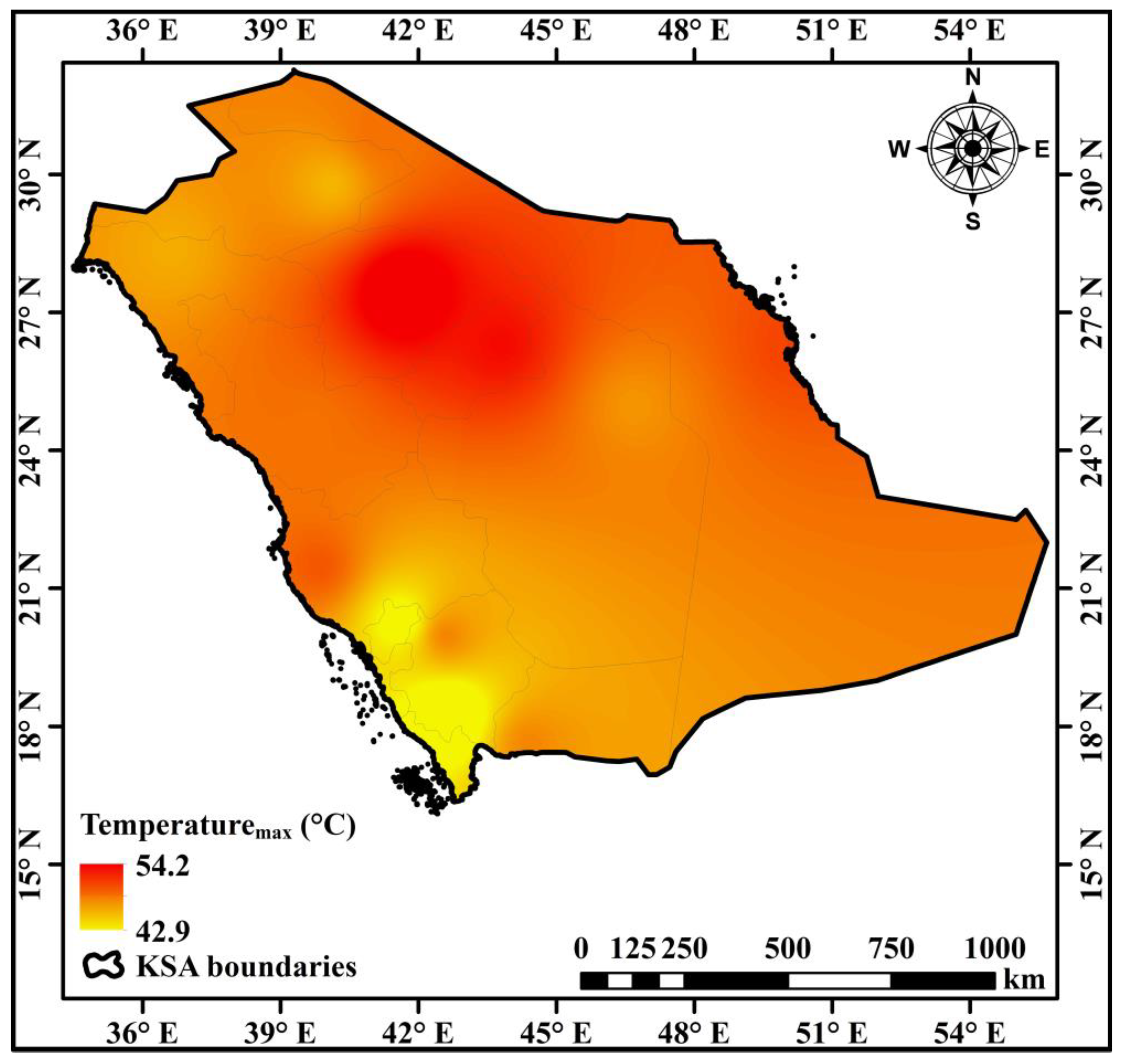
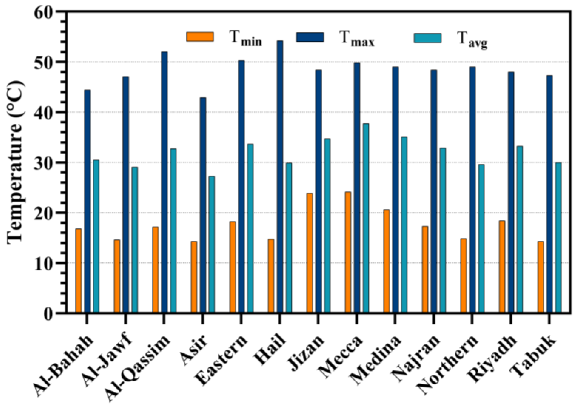
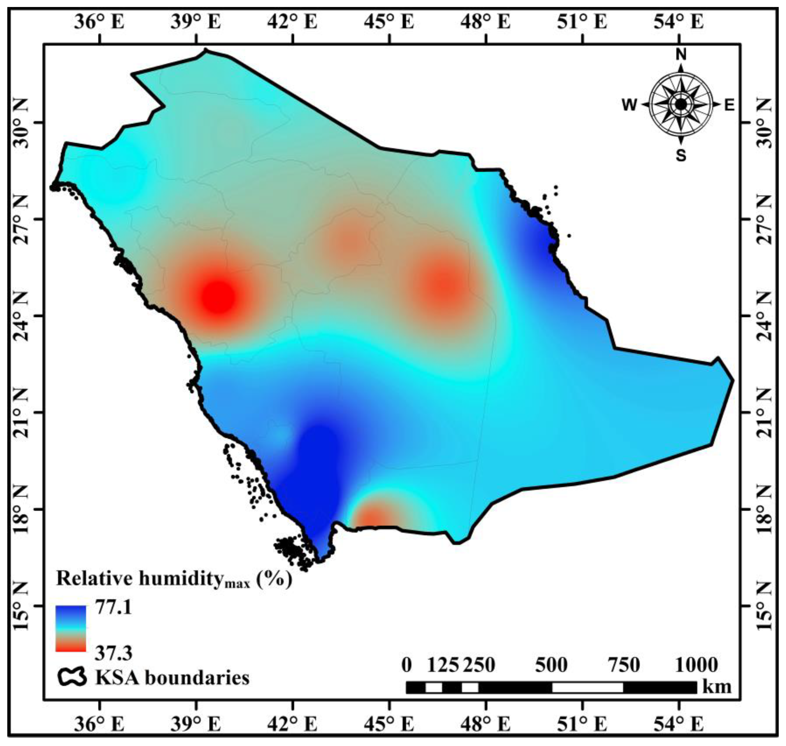
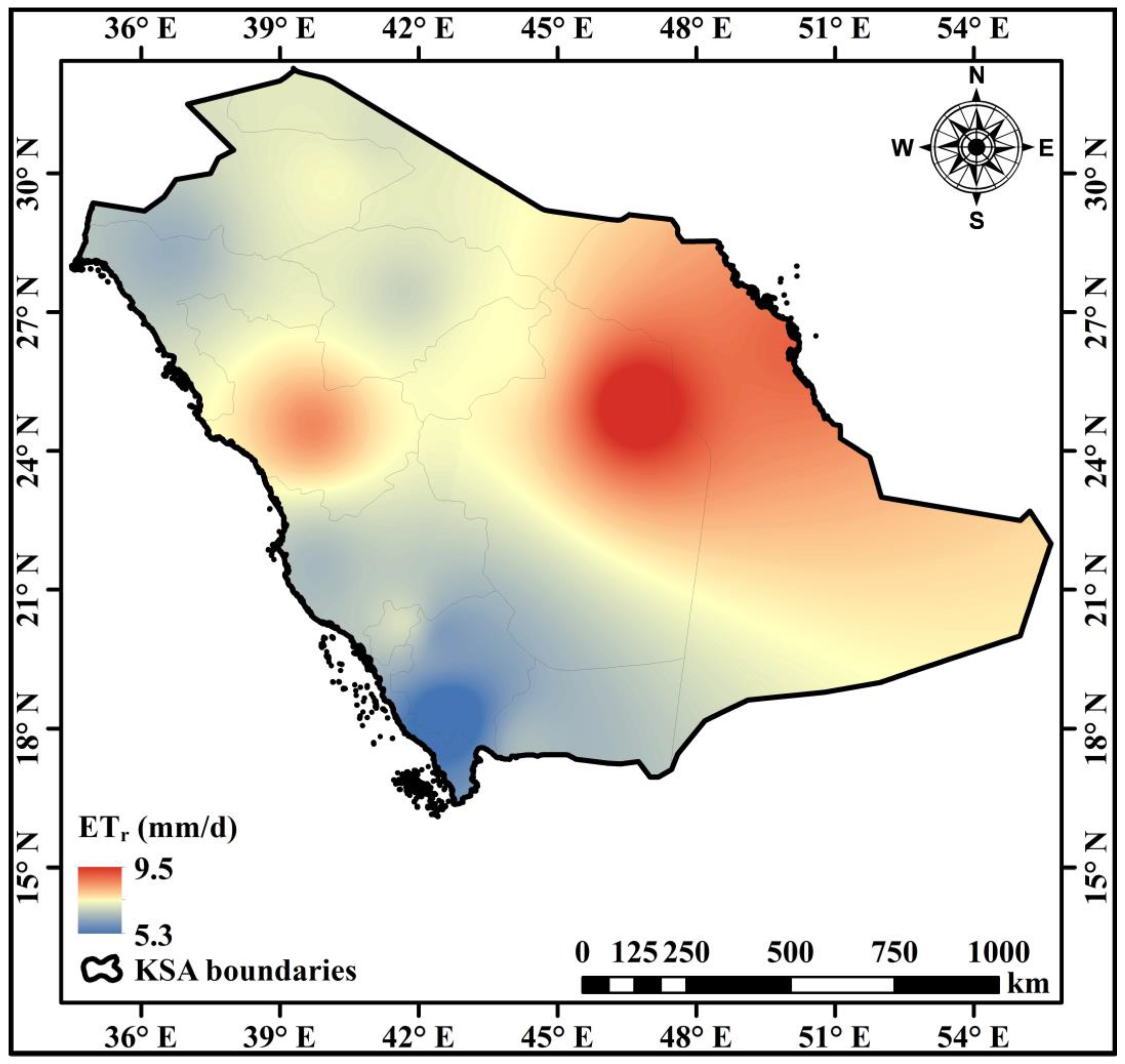
3.2. Historical Climatic Parameters

Localized ETr data are crucial in estimating the landscape water demand. A comprehensive analysis of 40 years of meteorological records from 13 regions within the Kingdom of Saudi Arabia reveals significant climatic diversity. Figure 3 presents the monthly average ETr for various regions in Saudi Arabia. The temperature map in Figure 4 classifies the temperatures into low, moderate, and high categories, highlighting the region’s substantial temperature fluctuations and the necessity of tailored landscape water management strategies. The recorded maximum temperatures ranged from 42.9 to 54.2 °C, indicating a pronounced thermal gradient. Figure 5 provides a detailed historical overview of the maximum, average, and minimum temperatures across the Kingdom from 1980 to 2021, illustrating the extensive temperature variations in Saudi Arabia. Notably, Asir recorded the lowest minimum temperature at 14.3 °C, while Hail reached the highest maximum temperature of 54.2 °C.
Regarding the humidity, Figure 6 and Figure 7 display a map of the relative humidity alongside historical data on the maximum, average, and minimum relative humidity for all regions of the Kingdom of Saudi Arabia from 1980 to 2021. The climatic analysis reveals significant variations in relative humidity across the kingdom. Medina reports the lowest minimum relative humidity at 14.9%, while Asir demonstrates the highest maximum relative humidity at 77.1%. Furthermore, maps depicting the wind speed and solar radiation underscore additional climatic differences, which are essential in comprehending the dynamics of the water demand. Figure 8 illustrates the Kingdom’s wind speed at a height of 2 m, with values ranging from 2.0 to 4.2 m/s. The solar radiation, the key energy source for evapotranspiration [26], is shown in Figure 9, with the measurements ranging from 16.4 MJ/m2/day at the Eastern Borders to 21.1 MJ/m2/day in Riyadh.

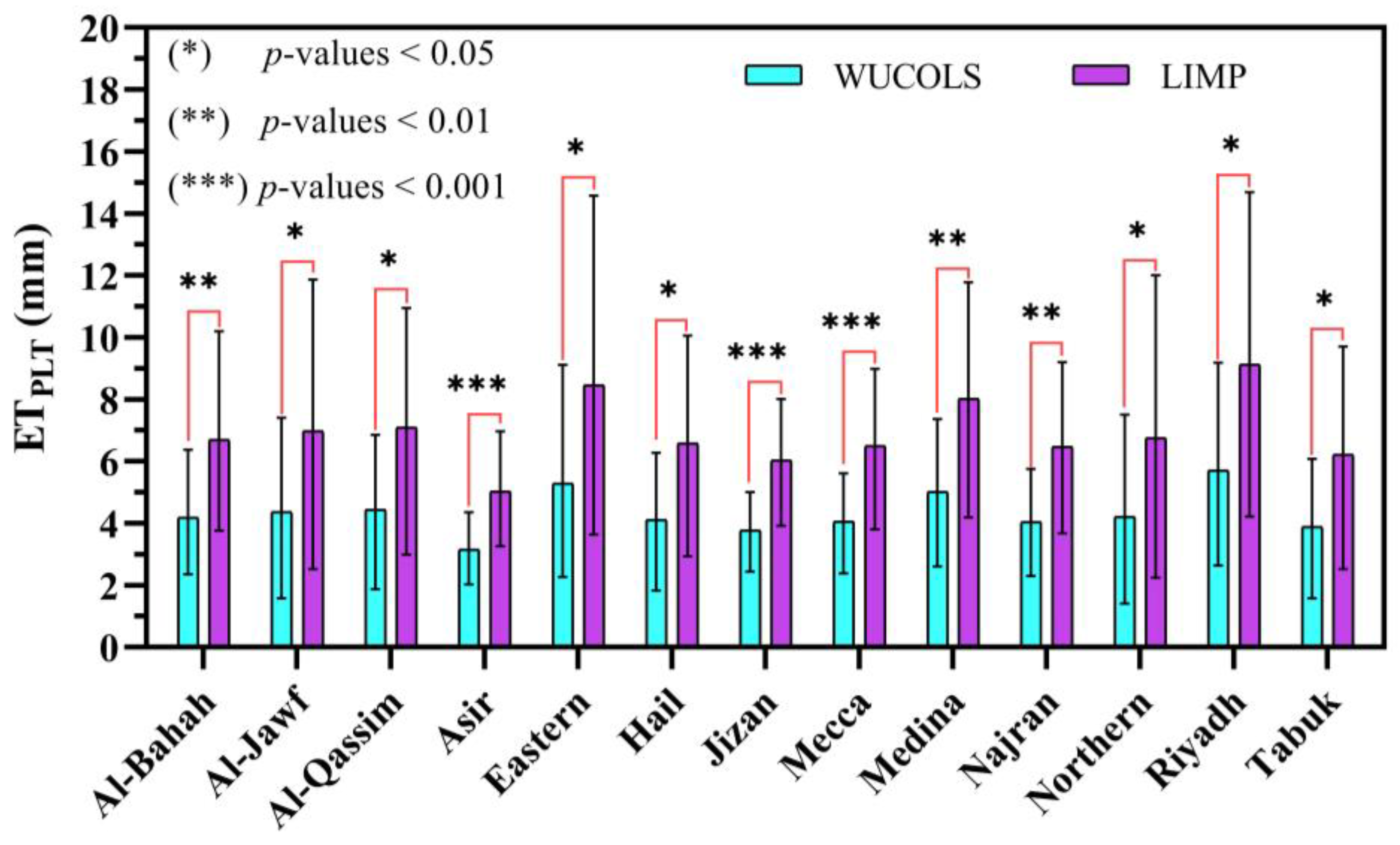
3.3. Landscape Water Demand Estimation

The variability in the ETr values is a significant finding that influences the estimation of the water demand. Desert territories, characterized by elevated ETr values, stand in stark contrast to coastal and mountainous territories. Additionally, various species of plants demonstrate distinct rates of ET, reinforcing the need for a more nuanced approach to water demand estimation. Table 3 and Table 4 present the landscape plant evapotranspiration (ETPLT) monthly average values for the KSA regions as determined by both WUCOLS and LIMP, covering the periods from January to June and July to December, respectively.
Regarding LIMP and WUCOLS, a comparison of their means was performed with an independent-sample T-test to determine which one could enhance the irrigation water sustainability through reducing ETPLT. In the figures, significant ETPLT differences at the 5% level are flagged with one or more asterisks (*). One asterisk (*) corresponds to a p-value of less than 0.05. Two asterisks (**) indicate p-values of less than 0.01. Three asterisks (***) correspond to p-values of less than 0.001. Otherwise, results marked as not significant (ns) indicate p-values exceeding 0.05. The comparison considered the species and managed stress factors. The results of the statistical analysis between the daily average ETPLT on a monthly basis for the KSA regions with respect to WUCOLS (moderate Ks) and LIMP (low, moderate, and high Ksm) are displayed in Figure 10, Figure 11 and Figure 12, respectively.
This study provides a scientifically grounded framework for the estimation of landscape water requirements in arid regions. By incorporating climate-based approaches and taking into account various plant traits, this research establishes a basis for sustainable and efficient water management in such landscapes. The findings demonstrate the versatility of the landscape coefficient formula across different contexts, offering valuable insights for both novice and seasoned managers. The deeper comprehension of the species and managed stress improves the accuracy of water demand estimates, which is essential for effective landscape water management in arid climates.
This study highlights the vital importance of effective water management strategies in alleviating the effects of climate change and water scarcity in the KSA territories. By calculating the water requirements of landscape plants through a Penman–Monteith-based method in conjunction with two decoupling approaches, this research offers valuable insights toward enhancing water use in hyper-arid regions. The results carry significant implications and pave the way for future exploration. If the proposed strategies are implemented on a broader scale, they could greatly improve the water use efficiency throughout Saudi Arabia. Such enhancements would yield both environmental and economic advantages. Environmentally, optimizing water usage could foster more sustainable urban environments, alleviating the pressure on scarce water resources and supporting biodiversity. Economically, more efficient water management could lower expenses related to water supply and irrigation, allowing resources to be allocated to other essential sectors.

4. Discussion

Although the implementation of ET-based scheduling to enhance irrigation water efficiency has recently seen significant progress, there remains a need to refine ET estimation in areas characterized by diverse microclimates and heterogeneous vegetation, as it is not feasible to measure ET through conventional techniques in this context [21]. This paper describes and compares the Water Use Classification of Landscape Species (WUCOLS) and the Landscape Irrigation Management Program (LIMP) model to address these problems.
By deepening our comprehension of the landscape irrigation water demand, we can make a substantial contribution to sustainable water resource management. The water saved through such rationalizing efforts could be subsequently redirected to satisfy the increasing requirements of the burgeoning population, in addition to supporting national development projects. Ultimately, a holistic and cohesive strategy for water resource management—one that considers the specific requirements of both the farming and landscaping sectors—is essential in tackling the intricate and complex challenges posed by water insufficiency [19].
The oversight of irrigated urban landscapes has become a major challenge, especially as it intersects with the demands posed by droughts driven by climate change. To preserve the ecological and economical significance of these areas while adapting to decreasing water supplies, effective water management strategies for landscapes are crucial. Central to these approaches is the vital task of accurately determining the plant water needs of the landscape, which could be satisfactorily addressed by irrigation, thereby meeting essential performance standards. Traditional approaches to estimating water requirements for landscapes have frequently lacked clarity in their conceptual frameworks and, on occasion, have proven unsuitable for specific regional contexts [47].
This highlights the necessity of a fundamental change in urban irrigation management techniques and rationalization policies. Precisely assessing the landscape irrigation water demands (WDPLT) and their associated irrigation demands is essential. In this regard, this research explored various mathematical models to estimate the water demand for landscape plants (WDPLT), emphasizing methodological rigor and justifiability. This study contrasted two climate-based approaches that rely on localized reference evapotranspiration (ETr) data and a reliable landscape plant coefficient (KPLT). These methods provide a logical and robust way to assess water demands. They are grounded in the essential principle that the water demands of plants are closely connected to the distinct features of the local climate. ETr, as a measure, encompasses the overall evapotranspiration, either by evaporation from the soil surface or by transpiration from plants [48].
By taking these climate-related factors into account, future studies can produce more accurate assessments of the water requirements for landscape plants. These plants are often subjected to deficit irrigation, implying that they obtain a lower volume of water than their natural demands. In landscape management, it is a common to intentionally introduce a certain level of hydric stress into basic ET estimation [27]. This approach aims to reduce water usage without greatly affecting plants’ health or esthetic quality. Such considerations are crucial in sustaining and efficiently managing landscape water

4.1. Historical Climatic Parameters

The foundation of the method of assessing the landscape irrigation water demand is site-specific reference evapotranspiration (ETr) data sourced from a trustworthy provider. This information acts as the climatic benchmark in understanding the irrigation water needs of plants in the hyper-arid landscapes of the Kingdom of Saudi Arabia (KSA). An examination of meteorological data collected for four decades from the 13 territories of KSA revealed remarkable variation in climatic conditions. The temperature (T), wind speed (U2), relative humidity (RH), and solar radiation (RS) have shown notable fluctuations.
To enhance the comprehension of these climatic variabilities, the regions of KSA were classified meteorologically into three distinct classes, reflecting the administrative divisions. These classes were established according to climate parameters that are crucial in influencing the landscape irrigation water demand. As shown in Figure 4, the temperature map clearly demonstrates the thermal spectrum across KSA. The maximum temperatures recorded varied from 42.9 to 54.2 °C, indicating a significant thermal gradient. For clarification, this thermal spectrum was divided into three categories. As noted, the high category comprises the eastern region, Al-Qassim, and Hail, all of which display comparable temperature characteristics. In contrast, the low thermal category includes regions such as Asir and Al-Baha, which exhibit similar thermal traits. The moderate thermal category covers Riyadh, Al-Jawf, Jizan, Najran, Medina, Tabuk, the northern region, and Mecca. This research offers a detailed summary of the minimum, maximum, and average temperatures documented from 1980 to 2021. This timespan highlights the significant temperature variations within KSA. The highest maximum temperature of 54.2 °C was noted in Hail, while Asir recorded the lowest minimum temperature of 14.3 °C, as shown in Figure 5.
The relative humidity map (Figure 6) is an essential element in understanding the dynamics of the arid climate. Territories such as Madinah, Riyadh, Najran, and Al-Qassim together encompass a significant portion of the study region, belonging to the low category, with levels between 37.3% and 44.9%. Conversely, the highest relative humidity was recorded in the eastern, Jizan, and Asir regions, with 66.3% to 77.1%, together accounting for 32% of KSA. Finally, regions like Hail, Al-Jawf, the Northern Borders, Tabuk, Al-Baha, and Mecca, despite covering a reduced geographical extent, are classified within the moderate range of relative humidity, with 49.4% to 58.2%. Figure 7 offers an overview of the extremes of the relative humidity in KSA. Medina registered the lowest minimum relative humidity of 14.9%, highlighting its dry environment. Conversely, Asir shows the peak maximum relative humidity at 77.1%, indicating its comparatively increased humid conditions.
The wind speed across the kingdom at a 2 m height is illustrated in Figure 8, displaying a range of 2.0 to 4.2 m per second (m/s). This extensive spectrum of wind speeds is divided into three distinct classes, each exhibiting distinct regional representation. The “high” wind speed class, primarily represented by Al-Jawf, the eastern region, and Riyadh, features wind speeds of 3.6, 4.0, and 4.9 m/s, respectively. Conversely, the “low” wind speed class, including Mecca, Najran, Tabuk, and Al-Qassim, was identified with wind speeds of 2.0, 2.4, 2.8, and 2.9 m/s, respectively. Finally, territories like Asir, Medina, Jizan, Hail, the Northern Borders, and Al-Bahah are located within the “moderate” wind speed class with 3.0, 3.1, 3.2, 3.2, 3.3, and 3.4 m/s, respectively.
In Figure 9, we demonstrate the complexities of solar radiation across various regions of KSA. The map illustrates the unique distributions of the solar irradiance levels, which are crucial in estimating the landscape water demand. Hail, Najran, and Riyadh, covering 32% of the Kingdom’s area, display elevated levels of solar radiation, ranging from 18.7 to 21.1 MJ/m2/day. In contrast, the eastern region, Asir, and Tabuk, which together make up 39% of the Kingdom’s terrestrial area, are classified within the “low” solar radiation category. Here, the solar radiation values were 16.4, 16.7, and 17.5 mega-joules per square meter per day (MJ/m2/day), respectively. Meanwhile, the “moderate” solar radiation category, which spans from 18.0 to 18.6 MJ/m2/day, includes regions such as Al-Bahah, the Northern Borders, Al-Qassim, Al-Jawf, Jizan, Medina, and Mecca, comprising 29% of the Kingdom’s area. These areas exhibit relatively stable solar irradiance levels in relation to those in the “high” and “low” categories. These results highlight the significant climatic diversity present within KSA. The differences in solar radiation and the wind speed levels across various regions are crucial in influencing the landscape irrigation water demand. The interplay among these climatic variables and the water requirements will be examined in greater detail in the following section to deepen our comprehension of the dynamics of the arid climate and its effects on landscape irrigation water management strategies.

4.2. Landscape Water Demand Estimation

A significant finding of the analysis relates to the considerable fluctuations in the reference evapotranspiration (ETr) values. This variation is apparent not only within a single region across the year but also among different regions during the same month, as demonstrated in Figure 13. This fluctuation in ETr is attributed to the ever-changing characteristics of the elements that the ETr algorithm comprises, in addition to the topographic variations in terms of elevation. Figure 13 offers a visual representation of the distribution of the KSA territories according to their specific ETr ranges. Mountainous regions like Asir report the lowest ETr values, with Asir showing a minimal ETr of 5.3 mm. In sharp contrast, desert areas, which account for a substantial 63% of the Kingdom’s land mass, exhibit the highest ETr values. For instance, Riyadh distinguishes itself with an ETr value of 9.5 mm. Meanwhile, the coastal region of Mecca, situated near the Red Sea, falls within the moderate ETr range, featuring an ETr value of 6.8 mm.
It is essential to acknowledge that, under the same climatic conditions, various plant species display differing evapotranspiration (ET) rates, resulting in unique water requirements. This variation stems from the inherent physiological traits of the plants and their individual reactions to environmental influences. As mentioned in the Introduction, KSA has placed significant emphasis on the sustainable management of its scarce water resources. This can be accomplished through the management of water stress in plants [29]. To pursue this objective, we explored the potential for the implementation of different levels of water stress on mixed plant species.
Figure 10, Figure 11 and Figure 12 show the statistical analysis of the daily average ETPLT on a monthly basis for the KSA regions concerning WUCOLS (Ks, moderate) and LIMP (low, moderate, and high Ksm), respectively. Assigning a suitable KPLT for each territory involved the consideration of both approaches, utilizing the species, density, and microclimate for WUCOLS and the vegetation, density, microclimate, and managed stress for LIMP. The selected KPLT values are consistent with the landscape designs outlined in the Saudi Green Initiative, which usually require a mixture of plants forming at least two vegetation tiers [14]. To ensure a reliable comparison and comprehensive coverage, the analysis considered three levels of Ksm values [37] compared to the moderate well-watered Ks value [23] representing the predominant plants in KSA, thereby accommodating diverse scenarios.
As shown in Figure 10, the independent-sample T-test resulted in a significant difference in the ETPLT estimations between moderate Ks and low Ksm for all KSA regions. Some p-values were less than 0.05 (Al-Jawf: 0.0348, Al-Qassim: 0.0169, Eastern: 0.0273, Hail: 0.0137, Northern Borders: 0.0476, Riyadh: 0.0151, and Tabuk: 0.0204). In addition, the p-values of 0.0038, 0.0043, and 0.0013 were observed in Al-Baha, Medina, and Najran, respectively. Finally, the level of significance between WUCOLS and LIMP was raised, where a p-value of less than 0.001 was recorded for some regions (Asir: 0.0002, Jizan: 0.0002, and Mecca: 0.0009), which was reflected in a 37.5% decrease in the ETPLT value. By increasing the level of managed stress (Figure 11), the mean ETPLT calculated by the WUCOLS and LIMP models for all regions was found to be statistically not significant for all regions within KSA, where the p-values exceeded 0.05 for all regions. In this case, the landscape manager’s expertise becomes crucial, as they must decide which approach would save more water. This could be achieved by comparing the means of both the WUCOLS and LIMP approaches for each region. For the current case, the ETPLT obtained using WUCOLS was 16.67% lower than the ETPLT obtained by LIMP. Finally, the high Ksm in Figure 12 indicates no significant difference compared to the moderate Ks for all KSA regions except Asir and Jizan, where the p-values were 0.0429 and 0.0369, respectively. Although most regions had non-significant values, this case contrasted the previous one, where the ability to rationalize the landscape plants’ water demand favored the LIMP methodology, as the ETPLT means were less than those of WUCOLS, with around 20%.
The outcomes of the current study reveal that both WUCOLS and LIMP, as mathematical models, may offer a reliable method for more accurate ETPLT estimation. Moreover, it was found that decoupling Ks (WUCOLS) into Kv and Ksm (LIMP) could result in sustainable landscape irrigation management practices, especially when applying high managed stress. This finding aligns with Allen and Howell [49], who stated that the integration of plant species and managed water stress into Ks could result in inaccuracies when estimating the species coefficient. In this study, it is believed that the performance of the LIMP model was not strong enough compared with that of the WUCOLS model due to the absence of field measurements for the LIMP KPLT components. This interpretation is in alignment with the findings of Shojaei and Gheysari [46], who investigated the performance of the WUCOLS and LIMP models in the determination of urban landscape irrigation inside two sites, a botanical garden and a sparse forest park. Their findings revealed that the estimated water requirements for the WUCOLS model were 5% and 44% lower yearly, respectively, than those of LIMP. Shojaei and Gheysari [46] stated that using the values of Kv proposed by Allen and Howell [49] for the LIMP method may introduce errors and/or bias to the outcomes, as Kv is not measured locally.
The superior performance of WUCOLS has been highlighted in other research. Nouri and Glenn [50] performed a soil water balance (SWB) analysis and determined that plants consumed 1084 mm/year, which was close to the ETPLT based on the enhanced vegetation index (EVI) from the Moderate-Resolution Imaging Spectroradiometer (MODIS), which was 1088 mm/year. Meanwhile, the WUCOLS ETPLT was only 802 mm/year, around 26% lower than the SWB and EVI (MODIS) values. In the same vein, Elkatoury and Alazba [14] compared the WUCOLS model to a developed plant coefficient method (PCM). The developed PCM relied on using vegetation indices (VIs). The normalized difference vegetation index (NDVI) and leaf area index (LAI) were used instead of Ks and Kd, respectively. The results revealed that the average NDVI and LAI values were in agreement with the WUCOLS ranges and classifications. On the other hand, it is believed that using remote sensing technologies (RST) would enhance the performance of both the WUCOLS and LIMP models through providing the precise determination of each Ks, Kv, and Kd. However, RST require a great deal of knowledge and scientific tools to accomplish this goal, which may not be available to many landscape managers. However, mathematical models are considered easy to apply and affordable, either by obtaining KPLT values through field measurements or by depending on provided tabulated values.
To further clarify the practical application of KPLT with respect to both the WUCOLS and LIMP models, let us examine specific scenarios that demonstrate its use with mixed planting (≥2 layers). For the WUCOLS model, the Ks values were obtained from the Water Use Classification of Landscape Species manual [24], while the Kd and Kmc values were established based on the unique planting and site conditions [19]. Table 1 offers a succinct overview of the values assigned to each factor for ease of reference. In the case of the LIMP model, the Kv, Kd, Kmc, and Ksm values were sourced from G. Allen and L. Wright [37] (see Table 2). For further details, Table 3 and Table 4, along with the assigned plant-specific coefficients (KPLT), illustrate the estimated landscape evapotranspiration (ETPLT) values for all regions throughout the year.

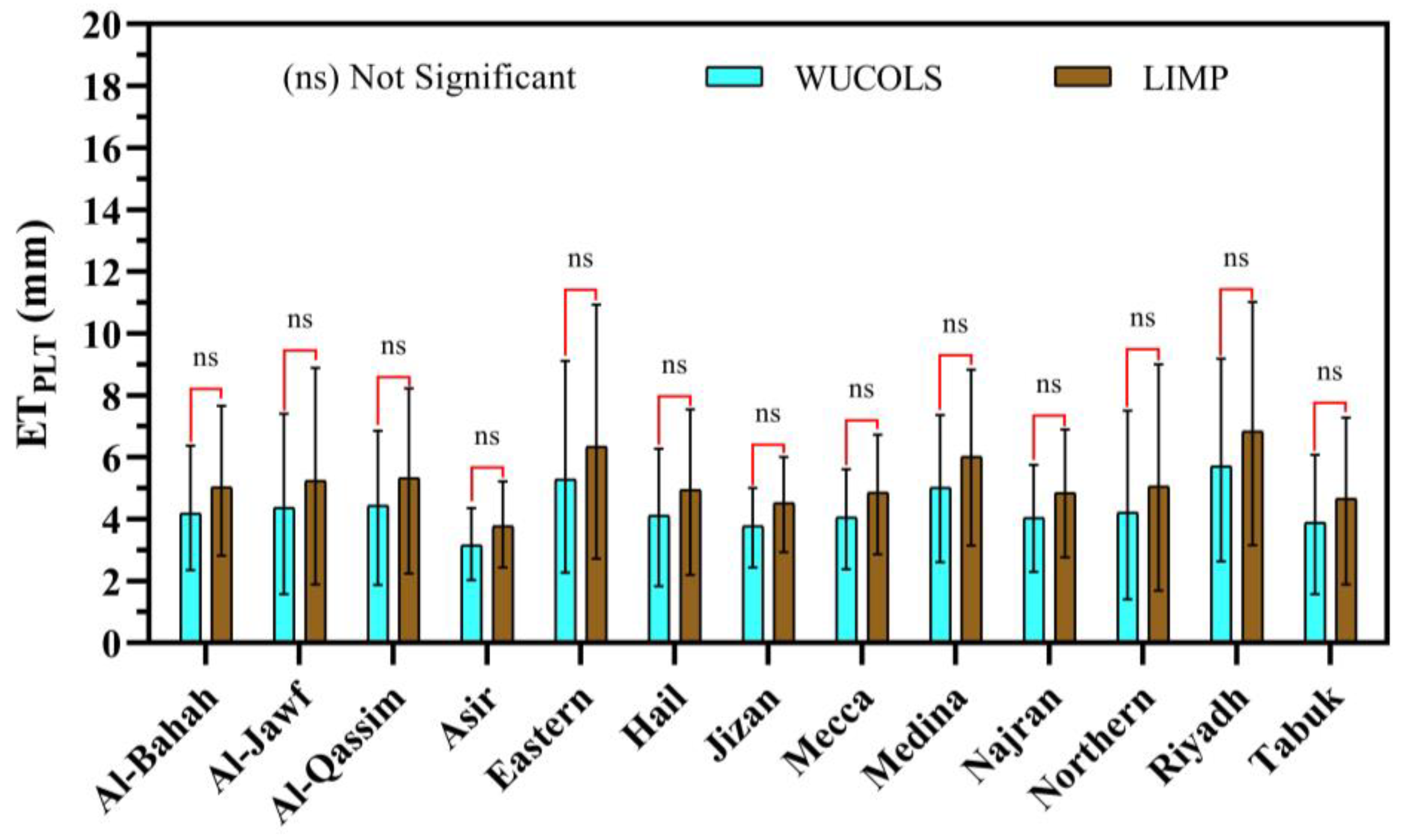
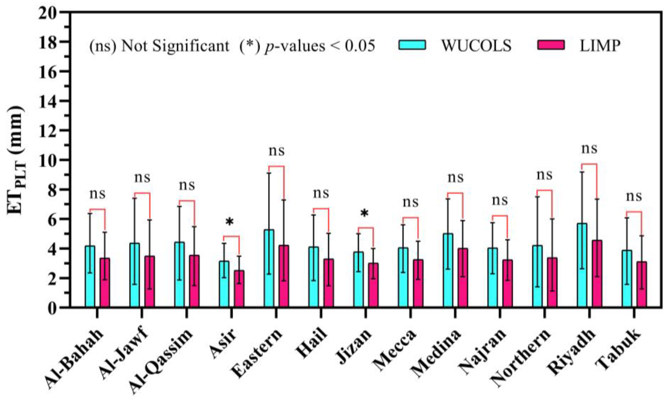
4.3. Exploring KPLT Component Scenarios: WUCOLS vs. LIMP

To further demonstrate the importance of each element within the decoupled KPLT formulas, this study delineates several distinct scenarios, each illustrating the contribution of Ks against the Ksm levels. According to Costello [23] and Ezzeldin and Alazba [19], when addressing mixed plantings, a moderate value for Ks can be allocated. The Kv for mixed species with (0.7–1) coverage remains constant at 1.2, while the Kd for canopies providing over 70% shading is set at 1. These scenarios clarify the complex interactions among the species (Ks), vegetation (Kv), density (Kd), microclimate (Kmc), and managed stress (Ksm) in establishing the landscape evapotranspiration (ETPLT) for various plantings in the Kingdom of Saudi Arabia (KSA). The ornamental plants selected for this research included species commonly utilized in KSA, spanning various categories such as trees (Tr), shrubs (Sh), and groundcover (GC). By analyzing a wide range of ornamental plants, we aimed to offer a thorough understanding of the water requirements across different plant types prevalent in the unique landscapes of KSA.
  • Case 1: Exploring Ks (moderate) vs. Ksm (low) scenario
A mixed planting of Acacia nilotica, Acasia iteaphylla, and Amaranthus tricolor, in a square park in Riyadh.
WUCOLS Analysis: According to the manual of Riyadh Plants, Acacia nilotica, Acasia iteaphylla, and Amaranthus tricolor fall into the low Ks category, with a designated range of 0.1 to 0.3. In this scenario, the planting is both mixed and mature, resulting in a moderate Ks value of 0.4, 0.5, or 0.6 being assigned. The upper value of 0.6 is allocated to reflect a well-watered condition. The planting is deemed mature, exhibiting full canopy coverage (70 to 100%). Given that it is mixed and comprises three layers of vegetation, it is categorized as having a high density (Kd = 1.2). The microclimatic conditions correspond to the ETr parameter, distinguished by direct sun exposure, an open environment, and minimal wind, yielding an average Kmc value of 1.
K P L T = 0.5 × 1.2 × 1 = 0.6
The subsequent step entails calculating the landscape evapotranspiration (ETPLT) using Equation (1), utilizing the ETr values presented in Figure 3. For the Riyadh region in July, the ETr value is 15.3 mm/day.
E T P L T = 0.6 × 15.3 = 9.18   m m / d a y
LIMP Analysis: In this scenario, the planting is both mixed and mature; thus, a constant value of 1.2 is assigned for Kv. The planting is regarded as mature, exhibiting full canopy coverage (70 to 100%) and is categorized as having a high density (Kd = 1). The microclimatic conditions correspond with the ETr parameters, distinguished by full sun exposure, an open space, and minimal wind, yielding an average Kmc value of 1. For this case, the landscape manager opted to apply a low intentional managed stress level (Ksm = 0.8).
K P L T = 1.2 × 1 × 1 × 0.8 = 0.96
The subsequent step entails calculating ETPLT as follows:
E T P L T = 0.96 × 15.3 = 12.24   m m / d a y
The results from the statistical analysis of ETPLT (Figure 10) for the Riyadh region clearly indicate a significant difference between the ETPLT values estimated by the WUCOLS model (moderate Ks) and the LIMP model (low Ksm), favoring the WUCOLS model. This finding is supported by Equations (14) and (16), which show that the ETPLT estimated by WUCOLS is around 25% lower than that calculated by LIMP.
  • Case 2: Exploring Ks (moderate) vs. Ksm (moderate) scenario
A mixed mature planting of Cassia fistula, Acacia ligulate, and Alcea rosea in a public park in Riyadh.
WUCOLS Analysis: The current scenario comprises a mixed planting of Cassia fistula, Acacia ligulate, and Alcea rosea, categorized as high-, low-, and moderate-Ks plants, respectively, based on the Manual of Riyadh Plants. For this case, a mid-range Ks value of 0.5 is assigned. It is a combination of mature plantings, thereby demonstrating complete canopy coverage and a high density (Kd = 1.2). The microclimatic conditions reflect the ETr conditions, distinguished by full sun exposure, an open space, and ordinary winds, yielding an average Kmc value of 1.
K P L = 0.5 × 1.2 × 1 = 0.6
The subsequent step entails calculating ETPLT as follows:
E T P L = 0.6 × 15.3 = 9.18   m m / d a y
LIMP Analysis: In this scenario, the planting is both mixed and mature; thus, a constant value of 1.2 is assigned for Kv. The planting is regarded as mature, exhibiting full canopy coverage (70 to 100%), and is classified as having a high density (Kd = 1). The microclimatic conditions correspond with the ETr parameters, distinguished by full sun exposure, an open space, and minimal wind, resulting in an average Kmc value of 1. For this case, the landscape manager opted to apply a moderate intentional managed stress level (Ksm = 0.6).
K P L T = 1.2 × 1 × 1 × 0.6 = 0.72
The subsequent step entails calculating ETPLT as follows:
E T P L T = 0.72 × 15.3 = 11.06   m m / d a y
The related result of the ETPLT statistical analysis for the current case (Figure 11) was flagged as non-significant (ns). This multiplies the landscape managers’ choices in selecting a model that fits their situation. For this case, it is clearly indicated that the choice is in favor of the WUCOLS model, as obtained through Equations (18) and (20), which show that the ETPLT estimated is around 17% lower than that calculated by LIMP.
  • Case 3: Exploring Ks (moderate) vs. Ksm (high) scenario
A mixed planting of Albizia lebbeck, Gardenia augusta, and Alocasia macrorrhiza at a public park in Riyadh.
WUCOLS Analysis: This scenario comprises a mixture of plants all with high Ks; the landscape manager has assigned a mid-range Ks value of 0.5. These plants are mature, have 100% canopy coverage, and belong to three different vegetation tiers. Consequently, this signifies a high-density planting, with a Kd value of 1.2 assigned. Additionally, the microclimate of the site is regarded as moderate, and a Kmc value of 1 is designated.
K P L T = 0.5 × 1.2 × 1 = 0.6
The subsequent step entails calculating ETPLT as follows:
E T P L T = 0.6 × 15.3 = 9.18   m m / d a y
LIMP Analysis: The planting is both mixed and mature; thus, a constant value of 1.2 is assigned for Kv. The planting is regarded as mature, exhibiting full canopy coverage (70 to 100%), and is classified as having a high density (Kd = 1). The microclimatic conditions correspond with the ETr parameters, distinguished by full sun exposure, an open space, and minimal wind, resulting in an average Kmc value of 1. For this case, the landscape manager opted to apply a high managed stress level (Ksm = 0.4).
K P L T = 1.2 × 1 × 1 × 0.4 = 0.48
The subsequent step entails calculating ETPLT as follows:
E T P L T = 0.48 × 15.3 = 7.34   m m / d a y
The related result of the ETPLT statistical analysis for the current case (Figure 12) was also flagged as non-significant (ns). In contrast to the previous case, the landscape manager’s decision may be in favor of the LIMP model as its value is around 20% lower than that calculated by WUCOLS, as obtained in Equations (22) and (24).
These field situations illuminate how the KPLT values are designated and employed in practice within the context of the WUCOLS and LIMP models. They highlight the significance of comprehending the various species, the differing vegetation densities, the effects of microclimatic fluctuations, and the role of intentionally managed stress in landscapes. It is essential to recognize that, in numerous instances, different irrigation zones may possess unique landscape coefficients. This study presents a method that assigns KPLT factor values in the mid-range of each category, which can be especially beneficial for managers with limited experience in these areas. For seasoned managers, adjusting these values becomes practical based on the specific conditions and needs.

5. Conclusions

Water conservation is a fundamental principle in the field of landscape design and management in arid climates. The decoupling methods for the landscape coefficient accommodate variations in the plant species, density, local climate, vegetation type, and managed stress. While both the WUCOLS and LIMP models provide factor-based estimations of the urban landscape water demand, significant differences exist in their coefficients and ranges. For example, the Kd coefficient in the LIMP model is calculated with greater precision than in the WUCOLS model. Furthermore, the Ks coefficient in the WUCOLS model incorporates the influences of both plant species and water stress, whereas the LIMP model treats these as distinct factors. These models can facilitate the achievement of water management objectives for landscapes that are increasingly focused on water rationalization, while preserving the overall vegetation vitality and esthetics. The comparative analysis of a moderate Ks with both low and high Ksm for ETPLT estimation indicated that the WUCOLS model yielded estimates that were 37.5% and 16.7% lower, respectively, than those obtained using the LIMP model. Moreover, the findings of this research reveal that the LIMP model could result in a 20% reduction in water usage at mixed planting locations by applying high levels of intentionally managed stress. Consequently, the WUCOLS model may potentially underestimate the landscape plant water demand. In contrast, the LIMP model appears more reliable due to its capacity to incorporate water stress into irrigation management, a factor that the WUCOLS model does not explicitly address.
The decoupling methods are somewhat complex in estimating the water requirements of landscapes that exhibit high variability, specifically when calculating ETr. This limitation can be addressed by integrating software applications where component coefficients can be selected from tables or determined through field measurements. In addition, the upper limit of 1.00 when modifying coefficients Kd, Kmc, and Ksm would simplify their estimation and reduce the associated uncertainties. In contrast, ETr estimation represents an inevitable limitation, where its considered local-based value depends on the local elevation and climatic parameters. The current research addressed such practical problems through mathematical models by determining ETPLT precisely utilizing a certified model. This was then used to calculate the irrigation water requirements for landscape plants in arid regions by translating them into water depths and water volumes. Considering the significant issue of water scarcity, intensified by urbanization and climate change in arid regions like Saudi Arabia, it is recommended to consider effective rainfall when preparing irrigation plans, where landscape plants managed in the high-stress category are not irrigated and rely on rainfall. In scenarios where water is applied, it is suggested to ensure that the average stress factor over the entire interval aligns with the desired value for Ksm by extending the irrigation interval to allow for progressively greater stress as the soil water diminishes between irrigations. It is also recommended to use alternative water sources, such as treated wastewater, for restricted and unrestricted landscape irrigation in arid areas. Moreover, it is strongly recommended to use drought-tolerant and native plants. Finally, further studies that implement real measurements of the decoupled approach’s components—Ks, Kd, Kmc, Kv, and Ksm—or implement field measurements of the actual landscape coefficients (i.e., lysimeters) are required.

Author Contributions

Conceptualization, M.E. and F.R.; data curation, M.E. and F.R.; formal analysis, M.E. and F.R.; investigation, F.R.; methodology, A.A.A., M.E. and F.R.; project administration, A.A.A.; software, M.E. and F.R.; supervision, A.A.A.; validation, M.E. and F.R.; visualization, M.E. and F.R.; writing—original draft, M.E. and F.R.; writing—review and editing, A.A.A., M.A.M., A.E.-S., M.E., F.R. and N.A. All authors have read and agreed to the published version of the manuscript.

Funding

This project was funded by the National Plan for Science, Technology and Innovation (MAARIFAH), King Abdulaziz City for Science and Technology, Kingdom of Saudi Arabia, award number (WAT1152) and the APC was funded by (MAARIFAH).

Data Availability Statement

The data can be provided by the appropriate author upon reasonable request.

Acknowledgments

This project was funded by the National Plan for Science, Technology and Innovation (MAARIFAH), King Abdulaziz City for Science and Technology, Kingdom of Saudi Arabia, Award Number (WAT1152).

Conflicts of Interest

No conflicts of interest are declared by the authors in relation to the publication of this research.

References

  1. Westall, F.; Brack, A. The Importance of Water for Life. Space Sci. Rev. 2018, 214, 50. [Google Scholar] [CrossRef]
  2. Al-Malki, W.M.; Al-Shamsan, S.I.; Al-Alewi, A.F.; Al-Shebil, M.A.; Al-Naser, I.S. Water problem and its implications for sustainable development. J. Econ. Adm. Leg. Sci. 2024, 8, 56–66. [Google Scholar]
  3. United Nations. Clean Water and Sanitation. 2022. Available online: https://unstats.un.org/sdgs/report/2023/Goal-06/ (accessed on 28 April 2025).
  4. Armstrong, M. Where Water Stress Will Be Highest by 2050. 2024. Available online: https://www.statista.com/chart/26140/water-stress-projections-global/ (accessed on 1 March 2025).
  5. El Kharraz, J.; El-Sadek, A.; Ghaffour, N.; Mino, E. Water scarcity and drought in WANA countries. Procedia Eng. 2012, 33, 14–29. [Google Scholar] [CrossRef]
  6. Oweis, T.; Hachum, A. Water harvesting and supplemental irrigation for improved water productivity of dry farming systems in West Asia and North Africa. Agric. Water Manag. 2006, 80, 57–73. [Google Scholar] [CrossRef]
  7. Gallardo, A.H.; Tase, N. Hydrogeology and geochemical characterization of groundwater in a typical small-scale agricultural area of Japan. J. Asian Earth Sci. 2007, 29, 18–28. [Google Scholar] [CrossRef]
  8. Partey, F.K.; Land, L.A.; Frey, B.; Premo, E.; Crossey, L. Final Report on the Geochemistry of Bitter Lake National Wildlife Refuge, Roswell, New Mexico; New Mexico Bureau of Geology and Mineral Resources: Socorro, NM, USA, 2011. [Google Scholar]
  9. McCabe, M.; AlShalan, M.; Hejazi, M.; Beck, H.; Maestre, F.T.; Guirado, E.; Peixoto, R.S.; Duarte, C.M.; Wada, Y.; Al-Ghamdi, S. Climate Futures Report: Saudi Arabia in a 3 Degrees Warmer World; KAUST, AEON Collective, KAPSARC: Thuwal, Kingdom of Saudi Arabia, 2023. [Google Scholar]
  10. Radwan, F.; Alazba, A. Integrated Hydrologic Study of the Arid and Semi-arid Regions using RST and GIS in the Riyadh Metropolitan Area, Saudi Arabia. J. Geol. Soc. India 2021, 97, 539–554. [Google Scholar] [CrossRef]
  11. Radwan, F.; Alazba, A.A.; Mossad, A. Flood risk assessment and mapping using AHP in arid and semiarid regions. Acta Geophys. 2019, 67, 215–229. [Google Scholar] [CrossRef]
  12. Al-Zahrani, K.H.; Baig, M. Water in the Kingdom of Saudi Arabia: Sustainable management options. J. Anim. Plant Sci. 2011, 21, 601–604. [Google Scholar]
  13. Armstrong, M. Where Groundwater Is (Not) Scarce. 2022. Available online: https://www.statista.com/chart/27274/water-stress-scarcity-current-situation/ (accessed on 1 March 2025).
  14. Elkatoury, A.; Alazba, A.A. Irrigation Water Demand Management-Based Innovative Strategy: Model Application on the Green Riyadh Initiative, Saudi Arabia. Water 2024, 16, 3559. [Google Scholar] [CrossRef]
  15. SGI. SGI Target: Grow 10 Billion Trees Across Saudi Arabia. 2021. Available online: https://www.sgi.gov.sa/about-sgi/sgi-targets/greening-saudi/ (accessed on 28 April 2025).
  16. Silva, J.A. Wastewater treatment and reuse for sustainable water resources management: A systematic literature review. Sustainability 2023, 15, 10940. [Google Scholar] [CrossRef]
  17. Al-Othman, A.A.; Kaur, P.; Imteaz, M.A.; Hashem Ibrahim, M.E.; Sillanpää, M.; Mohamed Kamal, M.A. Modified bio-electrocoagulation system to treat the municipal wastewater for irrigation purposes. Chemosphere 2022, 307, 135746. [Google Scholar] [CrossRef] [PubMed]
  18. Radwan, F.; Alazba, A.A. Suitable sites identification for potential rainwater harvesting (PRWH) using a multi-criteria decision support system (MCDSS). Acta Geophys. 2023, 71, 449–468. [Google Scholar] [CrossRef]
  19. Ezzeldin, M.; Alazba, A.A.; Alrdyan, N.; Radwan, F. Rationalizing Irrigation Water Consumption in Arid Climates Based on Multicomponent Landscape Coefficient Approach. Earth Syst. Environ. 2024, 9, 277–298. [Google Scholar] [CrossRef]
  20. Carlsen, L. Sustainability: An ethical challenge: The overexploitation of the planet as an exemplary case. Sustainability 2024, 16, 3390. [Google Scholar] [CrossRef]
  21. Snyder, R.L.; Pedras, C.; Montazar, A.; Henry, J.M.; Ackley, D. Advances in ET-based landscape irrigation management. Agric. Water Manag. 2015, 147, 187–197. [Google Scholar] [CrossRef]
  22. Shojaei, P.; Gheysari, M.; Myers, B.; Esmaeili, H. Quantifying microclimatic conditions: An attempt to more accurately estimate urban landscape water requirements. Urban For. Urban Green. 2020, 54, 126767. [Google Scholar] [CrossRef]
  23. Costello, L.R.; Matheny, N.P.; Clark, J.R.; Jones, K.S. A Guide to Estimating Irrigation Water Needs of Landscape Plantings in California, the Landscape Coefficient Method and Wucols III; University of California Cooperative Extension, California Department of Water Resources: Sacramento, CA, USA, 2000. Available online: https://cimis.water.ca.gov/Content/PDF/wucols00.pdf (accessed on 11 November 2022).
  24. WUCOLS. Water Use Classification of Landscape Plants. 2022. Available online: https://ccuh.ucdavis.edu/wucols (accessed on 11 November 2022).
  25. Khajeddin, S.; Matinkhah, S.; Jafari, Z. A drought resistance index to select drought resistant plant species based on leaf water potential measurements. J. Arid Land 2019, 11, 623–635. [Google Scholar] [CrossRef]
  26. Waller, P.; Yitayew, M. Landscape Irrigation Design and Management. In Irrigation and Drainage Engineering; Springer: Berlin/Heidelberg, Germany, 2016; pp. 271–288. [Google Scholar]
  27. Allen, R.G.; Dukes, M.D.; Snyder, R.L.; Kjelgren, R.; Kilic, A. A review of landscape water requirements using a multicomponent landscape coefficient. Trans. ASABE 2020, 63, 2039–2058. [Google Scholar] [CrossRef]
  28. Alodah, A. Towards sustainable water resources management considering climate change in the case of Saudi Arabia. Sustainability 2023, 15, 14674. [Google Scholar] [CrossRef]
  29. Nouri, H.; Beecham, S.; Kazemi, F.; Hassanli, A.M. A review of ET measurement techniques for estimating the water requirements of urban landscape vegetation. Urban Water J. 2013, 10, 247–259. [Google Scholar] [CrossRef]
  30. Jaber, S.M.; Abu-Allaban, M.M.; Sengupta, R. Spatial and temporal patterns of indicators of climate change and variability in the Arab world in the past four decades. Sci. Rep. 2023, 13, 15145. [Google Scholar] [CrossRef] [PubMed]
  31. Sadry, B.N.; Abdel Maksoud, K.M.; Zahabnazouri, S. Geotourism Development in the Middle East: A Comparative Study of Iran, Saudi Arabia, Oman and Jordan. In Tourism Planning and Development in the Middle East; CABI GB: Wallingford, UK, 2022; pp. 126–141. [Google Scholar]
  32. Alsharhan, A.S.; Kendall, C.G.S.C. Paleozoic sequence stratigraphy, depositional systems, and hydrocarbon habitats across the Arabian plate. AAPG Bull. 2021, 105, 1149–1198. [Google Scholar] [CrossRef]
  33. Radwan, F.; Alazba, A.A.; Mossad, A. Analyzing the geomorphometric characteristics of semiarid urban watersheds based on an integrated GIS-based approach. Model. Earth Syst. Environ. 2020, 6, 1913–1932. [Google Scholar] [CrossRef]
  34. Baig, M.B.; Alotibi, Y.; Straquadine, G.S.; Alataway, A. Water resources in the Kingdom of Saudi Arabia: Challenges and strategies for improvement. In Water Policies in MENA Countries. Global Issues in Water Policy; Springer: Cham, Switzerland, 2020; pp. 135–160. [Google Scholar]
  35. Eisenhauer, D.E.; Martin, D.L.; Heeren, D.M.; Hoffman, G.J. Irrigation Systems Management; American Society of Agricultural and Biological Engineers (ASABE): St. Joseph, MI, USA, 2021. [Google Scholar]
  36. Snyder, R.; Eching, S. Landscape Irrigation Management Program—IS005 Quick Answer; University of California: Los Angeles, CA, USA, 2004. [Google Scholar]
  37. Allen, R.G.; Wright, J.L.; Pruitt, W.O.; Pereira, L.S.; Jensen, M.E. Chapter 8. Water Requirements. In Design and Operation of Farm Irrigation Systems, 2nd ed.; American Society of Agricultural and Biological Engineers: St. Joseph, MI, USA, 2007; pp. 208–288. [Google Scholar]
  38. Snyder, R.L.; Eching, S. Urban landscape evapotranspiration. J Landsc. Water use. Calif. Water Plan Update 2005, 4, 691–693. [Google Scholar]
  39. Richard, L.S. Landscape Irrigation Scheduling Trends in California—From WUCOLS to LIMP. In 5th National Decennial Irrigation Conference Proceedings, 5–8 December 2010, Phoenix Convention Center, Phoenix, Arizona USA; ASABE: St. Joseph, MI, USA, 2010. [Google Scholar]
  40. Alazba, A.A.; Matter, M.A.; El-Shafei, A.; Radwan, F.; Ezzeldin, M.; Alrdyan, N. Comparative Analysis of ANN, GEP, and Water Advance Power Function for Predicting Infiltrated Water Volume in Furrow of Permeable Surface. Water 2025, 17, 1304. [Google Scholar] [CrossRef]
  41. Fitriani, V.; Bowo, C.; Mandala, M.; Gandri, L. Comparison of Empirical Methods to Estimated Reference Evapotranspiration. J. Ilm. Rekayasa Pertan. Dan Biosist. 2024, 12, 177–192. [Google Scholar]
  42. Howell, T.; Steiner, J.; Schneider, A.; Evett, S.; Tolk, J. Evapotranspiration of Irrigated Winter Wheat, Sorghum, and Corn; American Society of Agricultural Engineers (ASAE): Michigan, IN, USA, 1994. [Google Scholar]
  43. Allen, R.G.; Jensen, M.E.; Wright, J.L.; Burman, R.D. Operational estimates of reference evapotranspiration. Agron. J. 1989, 81, 650–662. [Google Scholar] [CrossRef]
  44. Allen, R.G.; Pereira, L.S.; Raes, D.; Smith, M. Crop Evapotranspiration-Guidelines for Computing Crop Water Requirements-FAO Irrigation and Drainage Paper 56; Food and Agriculture Organization of the United Nations: Rome, Italy, 1998; Volume 300, p. D05109. [Google Scholar]
  45. Pollock, P.H., III; Edwards, B.C. An IBM® SPSS® Companion to Political Analysis; CQ Press: Washington, DC, USA, 2025. [Google Scholar]
  46. Shojaei, P.; Gheysari, M.; Nouri, H.; Myers, B.; Esmaeili, H. Water requirements of urban landscape plants in an arid environment: The example of a botanic garden and a forest park. Ecol. Eng. 2018, 123, 43–53. [Google Scholar] [CrossRef]
  47. Kjelgren, R.; Beeson, R.C.; Pittenger, D.P.; Montague, T. Simplified landscape irrigation demand estimation: SLIDE rules. Appl. Eng. Agric. 2016, 32, 363–378. [Google Scholar]
  48. Pittenger, D. Methodology for Estimating Landscape Irrigation Demand Review and Recommendations. 2014. Available online: https://scholar.google.com.eg/scholar?hl=ar&as_sdt=0%2C5&q=48.+Pittenger%2C+D.+Methodology+for+Estimating+Landscape+Irrigation+Demand&btnG= (accessed on 28 April 2025).
  49. Allen, R.G.; Howell, T.; Snyder, R. Irrigation Water Requirements. In Irrigation, 6th ed.; Irrigation Association: Falls Church, VA, USA, 2011; pp. 93–172. [Google Scholar]
  50. Nouri, H.; Glenn, E.P.; Beecham, S.; Chavoshi Boroujeni, S.; Sutton, P.; Alaghmand, S.; Noori, B.; Nagler, P. Comparing three approaches of evapotranspiration estimation in mixed urban vegetation: Field-based, remote sensing-based and observational-based methods. Remote Sens. 2016, 8, 492. [Google Scholar] [CrossRef]
Figure 1. Study area map: (a) global map (adapted from Google Earth), (b) location map of Saudi Arabia.
Water 17 01429 g001
Figure 2. Applied methodology for estimation of landscape plants’ water demands.
Water 17 01429 g002
Figure 3. Boxplot of the daily average reference evapotranspiration (ETr), on a monthly basis, for various regions in Saudi Arabia.
Water 17 01429 g003
Figure 4. The maximum daily temperature map of the study area.
Water 17 01429 g004
Figure 5. The maximum, average, and minimum temperatures (°C) of all regions between 1980 and 2021.
Water 17 01429 g005
Figure 6. The average maximum daily relative humidity map of the investigated area.
Water 17 01429 g006
Figure 7. The maximum, average, and minimum relative humidity (%) of all regions between 1980 and 2021.
Water 17 01429 g007
Figure 8. The daily average wind speed map at a 2 m height across the entire country.
Water 17 01429 g008
Figure 9. The daily average solar radiation map of the studied area.
Water 17 01429 g009
Figure 10. Statistical analysis of the daily average ETPLT on a monthly basis for Saudi Arabian regions with respect to WUCOLS (moderate Ks) and LIMP (low Ksm).
Water 17 01429 g010
Figure 11. Statistical analysis of the daily average ETPLT on a monthly basis for Saudi Arabian regions with respect to WUCOLS (moderate Ks) and LIMP (moderate Ksm).
Water 17 01429 g011
Figure 12. Statistical analysis of the daily average ETPLT on a monthly basis for Saudi Arabian regions with respect to WUCOLS (moderate Ks) and LIMP (high Ksm).
Water 17 01429 g012
Figure 13. The daily average reference evapotranspiration (ETr) map for various Saudi Arabian regions.
Water 17 01429 g013
Table 1. WUCOLS coefficient values [14,19,23].
FactorLowModerateHigh
Species (Ks)0.1–0.30.4–0.60.7–0.9
Density (Kd)0.5–0.911.1–1.3
Microclimate (Kmc)0.5–0.911.1–1.4
Table 2. LIMP coefficient values [37].
Vegetation CategoryKvKmcKsm
Low (b)Mod. (c)High (d)LowMod.High
Trees1.150.51.01.40.80.60.4
Shrubs, desert species0.700.51.01.30.60.40.3
Shrubs, non-desert species0.800.51.01.30.80.60.4
Groundcover1.000.51.01.20.80.50.3
Annuals0.900.51.01.20.80.70.5
Mixture: trees, shrubs, and groundcover (a)1.200.51.01.40.80.60.4
Turfgrass: cool season 0.900.81.01.20.90.80.7
Turfgrass: warm season 0.900.81.01.20.80.70.6
Notes: (a) Mixed plantings comprise two or three vegetation species where a single vegetation type does not predominate. (b) Sites shaded or protected from wind. (c) Sites’ conditions are equivalent to those used for ETr measurements. (d) Sites exposed to direct winds, heat inputs from adjacent sources, and/or reflected light.
Table 3. The daily average landscape plant evapotranspiration (ETPLT) on a monthly basis for various Saudi Arabian regions based on the WUCOLS and LIMP methodologies (January to June).
RegionJanuaryFebruaryMarch
WUCOLSLIMPWUCOLSLIMPWUCOLSLIMP
LMHLMHLMHLMHLMHLMH
Al-Bahah0.942.363.773.772.831.891.203.004.804.803.602.401.443.605.765.764.322.88
Al-Jawf0.631.572.522.521.891.260.902.263.613.612.711.811.313.295.265.263.942.63
Al-Qassim0.751.872.982.982.241.491.042.614.184.183.132.091.413.535.655.654.242.83
Asir0.822.063.303.302.471.651.002.493.983.982.991.991.213.014.824.823.622.41
Eastern0.912.273.633.632.721.811.102.754.394.393.292.201.543.866.186.184.633.09
Hail0.751.883.013.012.261.501.012.534.044.043.032.021.333.345.345.344.002.67
Jizan0.982.443.913.912.931.951.132.824.514.513.382.251.373.435.505.504.122.75
Mecca0.952.383.823.822.861.911.202.994.794.793.592.401.523.806.096.094.573.04
Medina1.052.614.184.183.142.091.333.335.335.334.002.671.754.376.996.995.243.49
Najran0.982.453.933.932.941.961.273.175.075.073.802.541.553.866.186.184.643.09
Northern Borders0.581.462.332.331.751.170.852.123.393.392.541.701.243.114.974.973.732.48
Riyadh1.062.644.234.233.172.111.443.615.775.774.332.881.904.757.597.595.703.80
Tabuk0.661.652.642.641.981.320.932.333.723.722.791.861.313.275.225.223.922.61
RegionAprilMayJune
WUCOLSLIMPWUCOLSLIMPWUCOLSLIMP
LMHLMHLMHLMHLMHLMH
Al-Bahah1.593.986.376.374.783.181.854.627.387.385.543.692.375.939.499.497.124.74
Al-Jawf1.844.597.357.355.513.672.335.839.339.337.004.672.766.8911.0211.028.275.51
Al-Qassim1.854.627.397.395.553.702.436.099.749.747.304.872.736.8410.9410.948.205.47
Asir1.313.275.235.233.922.611.493.735.965.964.472.981.744.356.966.965.223.48
Eastern2.025.058.088.086.064.042.847.1111.3711.378.535.693.649.1114.5714.5710.937.29
Hail1.784.457.127.125.343.562.235.588.928.926.694.462.486.219.939.937.454.97
Jizan1.614.036.446.444.833.221.804.497.197.195.393.591.944.857.777.775.833.88
Mecca1.824.547.277.275.453.632.065.148.228.226.174.112.245.618.988.986.734.49
Medina2.115.288.458.456.334.222.486.219.939.937.454.962.837.0911.3411.348.505.67
Najran1.704.256.806.805.103.401.944.857.767.765.823.882.165.408.648.646.484.32
Northern Borders1.784.467.137.135.353.572.375.929.479.477.104.742.786.9411.1111.118.335.55
Riyadh2.406.019.629.627.214.812.987.4611.9411.948.955.973.588.9514.3314.3310.747.16
Tabuk1.754.387.017.015.263.512.155.378.598.596.444.302.416.039.659.657.234.82
Table 4. The daily average landscape plant evapotranspiration (ETPLT) on a monthly basis for various Saudi Arabian regions based on the WUCOLS and LIMP methodologies (July to December).
RegionJulyAugustSeptember
WUCOLSLIMPWUCOLSLIMPWUCOLSLIMP
LMHLMHLMHLMHLMHLMH
Al-Bahah2.556.3710.2010.207.655.102.385.959.529.527.144.762.055.138.218.216.164.10
Al-Jawf2.967.4111.8611.868.895.932.716.7810.8510.858.145.432.265.659.039.036.784.52
Al-Qassim2.746.8510.9510.958.225.482.586.4410.3110.317.735.152.185.468.738.736.554.37
Asir1.634.086.536.534.903.261.453.635.815.814.362.911.513.786.046.044.533.02
Eastern3.518.7914.0614.0610.547.033.057.6112.1812.189.146.092.546.3510.1610.167.625.08
Hail2.516.2810.0510.057.545.032.355.879.399.397.044.692.025.068.098.096.074.05
Jizan2.005.018.018.016.014.001.864.647.437.435.573.711.714.286.856.855.143.43
Mecca2.145.368.578.576.434.282.005.018.028.026.014.011.844.597.357.355.513.68
Medina2.947.3611.7811.788.835.892.817.0311.2511.258.445.632.416.049.669.667.244.83
Najran2.305.759.209.206.904.602.165.418.668.666.494.331.904.747.587.585.693.79
Northern Borders3.007.5012.0012.009.006.002.636.5610.5010.507.885.252.145.348.548.546.414.27
Riyadh3.679.1814.6814.6811.017.343.318.2613.2213.229.926.612.626.5510.4710.477.855.24
Tabuk2.436.079.719.717.284.862.285.699.119.116.834.551.914.777.637.635.723.82
RegionOctoberNovemberDecember
WUCOLSLIMPWUCOLSLIMPWUCOLSLIMP
LMHLMHLMHLMHLMHLMH
Al-Bahah1.644.116.586.584.933.291.142.864.574.573.432.290.942.353.763.762.821.88
Al-Jawf1.654.116.586.584.943.290.962.403.833.832.871.920.651.612.582.581.941.29
Al-Qassim1.694.226.766.765.073.381.132.814.504.503.382.250.761.903.043.042.281.52
Asir1.223.054.894.893.662.440.922.293.673.672.751.830.812.033.253.252.441.63
Eastern1.934.827.717.715.783.851.353.375.405.404.052.700.952.373.803.802.851.90
Hail1.593.976.356.354.763.180.972.423.883.882.911.940.731.832.932.932.201.47
Jizan1.513.796.066.064.543.031.203.014.824.823.612.411.002.493.993.992.992.00
Mecca1.593.986.366.364.773.181.162.904.654.653.482.320.952.383.813.812.861.91
Medina1.874.687.507.505.623.751.393.485.575.574.182.781.092.714.344.343.262.17
Najran1.443.605.765.764.322.881.092.734.364.363.272.180.922.303.683.682.761.84
Northern Borders1.493.735.965.964.472.980.832.083.333.332.501.670.561.402.242.241.681.12
Riyadh1.944.847.757.755.813.881.423.565.705.704.272.851.052.634.214.213.162.10
Tabuk1.363.395.435.434.072.710.862.143.433.432.571.710.631.582.522.521.891.26
Disclaimer/Publisher’s Note: The statements, opinions and data contained in all publications are solely those of the individual author(s) and contributor(s) and not of MDPI and/or the editor(s). MDPI and/or the editor(s) disclaim responsibility for any injury to people or property resulting from any ideas, methods, instructions or products referred to in the content.

