Abstract
For decades, there has been ongoing discussion about whether centralized or decentralized wastewater management systems are better. Decision-makers need to define the best option but do not always have the necessary tools to develop, compare, and identify the most appropriate solution. To address this, studies have been conducted on a settlement level. In this study, the main focus was to develop and optimize wastewater management scenarios for a region containing rural areas, where data scarcity was an issue, by extracting scenario-relevant information from the region using a satellite image and its calibration using locally available data. We selected a study region in India containing 184 villages with a total population of around 210,000 and covering an area of around 400 km2. The study considered three different scenarios for the study area: centralized, decentralized, and an optimized scenario, which consists of a hybrid system involving partly decentralized and partly semi-centralized (clustered) infrastructure. The study developed a systematic approach for defining an optimized cluster of villages by considering the cost trade-off between the wastewater treatment plant (WWTP) capacity and sewer network layout. The results showed that the clustered and decentralized scenarios were nearly equal in terms of cost (around EUR 118 million), while the centralized scenario showed a relatively high cost of EUR 168 million. Potential applications and further development of the method were also considered. The proposed methodology may aid global wastewater management by estimating and optimizing infrastructure costs needed to fulfill Sustainable Development Goal 6 (SDG#6) in rural regions.
1. Introduction
Improving safe access to water and sanitation is defined as the United Nations’ (UN) sixth Sustainable Development Goal (SDG#6) [1]. As of 2022, more than half of the world’s population still lacks access to safe sanitation, indicating that SDG#6 may not be achieved despite recent efforts [2]. One of the main challenges related to SDG#6 is the considerable amount of investment required for long-term wastewater infrastructure in a short period [3]. However, there is currently a lack of planning tools for comprehensive analysis, spatial planning, scenario development, and cost estimates [4], despite several tools being developed and published recently. Investment decisions must be made based on studies and plans that reflect local conditions and needs to determine the most cost-effective solution for wastewater management [3].
While cities and urban areas are often prioritized for wastewater infrastructure implementation, this is not the case for rural regions due to their local and regional characteristics, such as the remoteness of settlements and relatively low population density within a large area [5,6]. In addition, the lack of sufficient data to carry out planning and estimation has been a hurdle for rural regions [7]. In contrast, cities have a high population density in a relatively small area, making implementation projects accessible to a higher population [7]. Urban areas also face higher risks from untreated wastewater in terms of human hygiene and health [8] due to the high population dwelling within a small area. Moreover, the improved data availability and planning capacity in urban areas compared to rural regions allow better planning and decision-making [9,10].
Traditionally, centralized systems are mostly used in urban settings [11], whereas decentralized infrastructures are applied in rural areas [12]. It has been reported that in traditional centralized systems, more than 80% of the investment costs are related to the sewer infrastructure [13]. In addition, centralized wastewater management systems are reported to be less flexible toward demographic changes, such as rapid growth or shrinkage of the population [14]. Despite their inflexibility, centralized systems are often the most cost-effective solution in densely populated urban areas [11]. In contrast, rural areas with a centralized system must rely on much longer sewer networks, making them unsuitable for this environment [15]. However, centralized sanitation infrastructure in rural areas, consisting of overextended networks and a common treatment plant, is typical in developed countries [16]. To investigate which system offers the best solution for a given local condition, different tools, approaches, and methods are necessary. This approach enables the development of various wastewater management scenarios and allows for the cost comparison of these solutions.
Recently, researchers have addressed the lack of planning and analysis tools by developing various methods to identify the most suitable solution on different scales [3,17,18,19]. These tools can be helpful for pre-planning and identifying the most appropriate sanitation solution to achieve SDG#6 at a local level, whereas other more indicator-based estimates have been used at a national level [20]. While such estimates are important at both the local and national levels, more comprehensive analysis and planning are needed to close the gap at the regional level.
In this context, the main objective of this study is to develop an approach that is used to address two main challenges that rural regions currently face regarding the infrastructure planning process: (1) to carry out preliminary planning for wastewater infrastructure in case of lack of available data, and (2) to identify the most suitable wastewater management scenario on a regional scale. The following measures have been taken to develop the approach.
The first step was to select a study area in India with a total area of about 400 km2. The number of inhabitants and villages was unknown and needed to be determined for this study. Second, the lack of available data in a rural region was handled by extracting the data needed for the analysis from satellite data (imagery), and the extracted data was adjusted and calibrated with local information before being used as input data for the scenario development process. Third, the pre-planning, scenario development, and optimization were carried out using a network analysis tool. Finally, a cost analysis was carried out to identify the region’s most appropriate wastewater management solution. The optimization was based on the cost trade-off between the capacity of the WWTP and the design layout of the trunk sewer network on a regional scale close to the clustered villages.
2. Materials and Methods
In this study, the analysis was carried out by defining the wastewater management scenarios, which was followed by the data collection and processing. Subsequently, the scenarios were spatially developed using a geographic information system (GIS). Then, the cost analysis was carried out combined with the identification/development of the optimized solution. The cost analysis considers the quantity of the infrastructure (such as the length and diameter of trunk lines and the size of the WWTP) extracted from GIS for each scenario and the investment as well as reinvestment and operation and maintenance (O&M) costs over the lifetime of the system [3].
Similarly to Khurelbaatar et al. [3], the current study focused on a data-scarce region in India. The main data source was a recent satellite image and globally available information to calibrate the data. In addition, this study aimed to develop wastewater management solutions for a region rather than a locality, and individual villages were considered to be wastewater sources. In comparison, previous studies developed scenarios for villages by considering individual buildings as sources of wastewater. Similar to the developed GIS-based decision support tool ALLOWS (Assessment of Local Lowest-cost Wastewater Solution) [17], this study also considered roads as the main route for the sewer network and trunk lines. The number of scenarios was adapted to the region and included (i) a decentralized scenario, (ii) a centralized scenario, and (iii) an optimized (clustered) scenario, which consists of part decentralized and partly semi-centralized infrastructure. The “Network Analysis” tool of ArcGIS was used as a new approach for designing and optimizing sewer networks.
2.1. Study Area
Countries like India, with a high population and rapid demographic growth, are prone to wastewater-related risks [12,21]. The study region with an area of about 400 km2 was selected in Aligarh District—Uttar Pradesh State, India (Figure 1) [22]. The study area (28°7′26.05″ N–28°0′28.75″ N, 78°15′32.87″ E–78°31′57.97″ E) was located in the Ganga River basin, which is of great importance to India owing to its historical, cultural, religious, ecological and economic background [23]. The lack of available data (except satellite imagery) and wastewater infrastructure, combined with the strong interest of funding agencies and local stakeholders to alleviate the current situation, made the study area suitable for developing and testing this new approach. In addition, the region has undergone rapid demographical development (30% population increase in the last decade [24]) and contains diverse settlements, including urban, semi-urban, and rural areas.
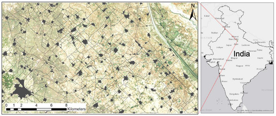
Figure 1.
Location of the study area.
2.2. Scenario Definition
For this study, three scenarios were developed to identify the optimal solution for wastewater management in the region of interest.
- Decentralized scenario: Each village is served by one WWTP;
- Centralized scenario: All villages in the study region are connected to a common centralized WWTP. Wastewater from the villages is conveyed to the centralized treatment plant through a combination of trunk lines and pumping stations;
- Clustered scenario: Based on the other two scenarios, they are the baseline for developing optimized clusters regarding the size of WWTPs and sewer network layout.
The economy of scale is reflected in the construction and O&M costs of WWTPs. The larger the population served, the lower the costs per inhabitant [18]. For this study, this meant that as the number of villages connected to a centralized WWTP increased, the specific costs decreased compared to decentralized WWTPs. This opened up the possibility of using the potential savings in WWTPs to invest in sewer networks to reduce the number of WWTPs, thus creating the clustered scenario. Given the economy of scale, the starting point for this study was to compare the fully decentralized and fully centralized systems to determine the cost difference in WWTPs and use this as a boundary condition to determine which villages could be clustered according to the length of trunk lines that could be funded with the available cost using Equation (1) and also shown in Figure 2.
where:
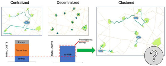
Figure 2.
Principal scenario development scheme.
ACCLUSTER: Available Cost for Cluster Network;
CDWWTP: Cost of Decentralized WWTP;
CCWWTP: Cost of Centralized WWTP.
All the scenarios were based on network analysis techniques to increase the size of the WWTPs and find the best level of clustering that lowered the cost of both the decentralized and centralized scenarios.
2.3. Data Requirement
The current study focused on developing wastewater management scenarios that could be modeled with minimal incorporation of local and regional data. Instead, it focused on using globally available data as much as possible. Khurelbaatar et al. [3] used a reduced data version of the ALLOWS tool and defined the minimum data required for scenario development as follows:
- Region of interest (ROI): Study region;
- Digital elevation model (DEM): A DEM with a resolution of 15 m × 15 m [25] was used in this study;
- Buildings: A satellite image [26] was used to digitize the buildings in each village;
- Roads: A satellite image [25] was used to manually delineate roads within the village and between villages for the whole study region;
- Population: Local statistical data [24];
- Water consumption: The average water consumption (Liters) per capita per day (80 Lpcd) was taken from MHFW [24]. Combined with the estimated population of the villages, the wastewater production for each village was determined;
- Costs: Investment and O&M costs associated with wastewater infrastructure, such as sewer pipes, pump stations, forced mains, and WWTPs [27].
2.4. Image Classification and Extraction of Data
For existing infrastructure, image classification of a recent satellite image from Microsoft Bing Maps was used [26]. The image was processed using the image classification tool of ArcGIS Pro Version 2.7.3 [28]. Image classification was an iterative process using training data to identify infrastructure relevant to the study, such as buildings and roads, with the highest possible accuracy. The study area was first divided into 53 subdivisions (Supplementary Figure S1), and training samples were developed for buildings, roads and agricultural areas in each of the sub-areas (Supplementary Figure S2). The image classification process was then carried out using the configurations listed in Supplementary Table S1.
After image classification, the raster image was converted into feature data (polygon), and information of interest, most importantly buildings, was extracted (Figure 3). The boundary of each village was delineated using the buffer tool of ArcGIS Pro Version 2.7.3 [28].

Figure 3.
Image classification process: (a) raw satellite image, (b) image classification process, and (c) conversion to feature and extraction of the data. Delineation of roads was completed manually and processed so the feature data could later be used for the network analysis tool.
2.5. Estimation of Population for the Study Area
The number of buildings was integrated into the feature data as an attribute at the village level. In the next step, data on the villages were compared to a Google map and the names of the villages were added manually. The last census conducted in the area was in 2011 [24] and provided information on 85 of the 184 villages identified in the study region. First, the population forecast [24] was used to estimate the population for each identified village for the year 2021, the assumed approximate date of the satellite image. An average number of inhabitants per building was calculated for the 85 villages whose names and numbers of inhabitants were recorded in the census. This average population per building was then applied to other unidentified villages for which the number of buildings was already known to estimate the total population for each village as well as for the entire study region (Supplementary Table S2). In the next step, the estimated and reported populations were projected to 2036 according to the “Population Projection for India and states 2011–2036” [24]. Based on the population and reported water consumption of 80 Lcpd [29], the total wastewater production for the villages was calculated (Equation (2)).
2.6. Technical Details of the Sewer Network
The sewer network design was based on “The Manual on Sewerage and Sewage Treatment Systems of India” [29]. The peak flow of the sewer network was calculated using Equation (2).
where:
QD: peak flow (m3/s);
Rc: return coefficient (0.8 according to [30]);
P: projected population;
Wc: water consumption (m3/(day × inhabitant));
Pf: peak factor.
Peak factors were selected according to the size of the village. For villages with less than 20,000 inhabitants, Pf = 3 is recommended, whereas for settlements between 20,000 and 50,000 inhabitants, Pf = 2.5 is recommended. For urban settlements with more than 50,000 inhabitants, Pf = 2.25 was considered according to CPHEEO [29] (Supplementary Table S3). After calculating the peak flow, the size of trunk lines for each village was defined, along with the minimum slope, as listed in Table 1.

Table 1.
Pipe size and corresponding minimum slope [29].
The minimum depth of a trunk line was considered to be 1 m in accordance with CPHEEO [29], whereas the maximum depth was around 5 m. When the level of the gravity trunk line reached 5 m in depth, a lift station was considered to be installed. The average distance between the lifting stations for each village was calculated based on the size of the trunk and the minimum slopes. The average distance between manholes was considered to be 100 m.
As this study focused primarily on developing regional solutions rather than local management options, the sewer network within the village was assumed to be in place. Therefore, these technical details were only applied to the trunk-line network connecting the villages.
2.7. Developing the Trunk-Line Network Using the ArcGIS Network Analysis Tool
The network dataset was created from all existing roads in the study area. The network analysis tool used in this study (location–allocation, service area, and closest facility) was not specifically designed for wastewater network analysis but for road travel cases. However, relevant factors were included, such as the longest potential length of the trunk line, including a lifting station as a function of the cost of overall wastewater infrastructure, and the analysis was adapted to generate the trunk-line network between villages in the study area. Elements of the network dataset created for this study are mentioned below:
- Edges: Connected elements such as junctions and represented the links through which wastewater was transported;
- Junctions: Represented villages and nodes along the roads, connected to edges, and facilitated navigation from one edge to another;
- Travel distance: The pipe length potentially assigned to each village.
Edges and junctions form the basic structure of a network. Connectivity in the network dealt with the interconnection of edges and junctions, thus showing possibilities for transporting wastewater from the producer villages to WWTPs.
2.8. Economic Assessment
Unlike previous studies using the ALLOWS tool, where the economic assessment was conducted after the scenarios were developed [3,18], the economic assessment in this study was conducted alongside the scenario development process. The spatial data of the scenarios are summarized in Figure 4.
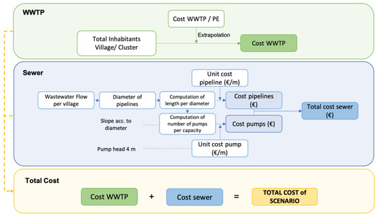
Figure 4.
Procedure to determine the investment costs of different scenarios.
The capital, reinvestment, and operation and maintenance (O&M) costs of the wastewater infrastructure were estimated using local and international benchmark costs (Supplementary Table S4 for WWTPs, Supplementary Table S5 for the trunk-line network, and Supplementary Table S6 for pumping stations). The net present value of each scenario was calculated according to DWA [31]. The analysis period was considered to be 60 years, and the discount rate was 3% per annum. The discounting factor for individual cost items (DFACIC) and discounting factor for uniform cost series (DFACS) were calculated as described in Supplementary Table S7. The lifespan of the wastewater infrastructure is shown in Supplementary Table S8.
Sequencing batch reactor (SBR) technology was selected for all the scenarios in the study that were solely based on the cost data availability. The investment, reinvestment, and O&M costs were defined according to Ettenauer’s [27] estimates for different sizes of WWTP (Supplementary Table S4).
2.9. Decentralized Scenario
The fully decentralized scenario assumed that each of the 184 villages had its own WWTP, so no expenditure was needed to install pipes and pumping systems to connect the villages. The location of the WWTP was assumed to be within the boundary of each village, and its size was derived from the projected population. Investment, O&M, and reinvestment costs were computed from the SBR cost functions shown in Supplementary Table S4 and were calculated for each WWTP and village. The present value was determined over the analysis period of 60 years. The sum of the costs of each WWTP yielded the total cost of the decentralized scenario, and their present value was determined for later comparison with the other scenarios.
2.10. Centralized Scenario
In the centralized scenario, a trunk-line network was designed that connected all villages to a common (centralized) WWTP. The location of the centralized WWTP was selected based on the lowest cost criterion. The location–allocation tool of ArcGIS Pro Version 2.7.3 [28] was applied to the created network dataset to determine the location of the centralized WWTP. Weighted impedance minimization was considered, and the lowest amount of wastewater that must be transported through the shortest length of pipe was sought. Once the location of the WWTP was determined, the exact length of the trunk line per diameter for the entire network was determined using the network analysis tools (copy traversed source features, closest facilities—ArcGIS Pro Version 2.7.3). This also considered the changing pipe size as villages were gradually connected to the network. In a final step, spatial data, such as the length of trunk lines with various diameters, number of manholes, number and size of pumping stations, and size of the centralized WWTP, were summarized for the economic assessment.
2.11. Clustered Scenario
One of the crucial points in developing the clustered scenario was defining which villages could be combined into a cluster and connected to a common WWTP without exceeding the costs of the other scenarios. For this purpose, the difference in treatment cost between the decentralized and centralized scenarios was calculated. The cost difference divided by the total population was used to estimate the potential savings per inhabitant in the region (Figure 5), and then the potential savings for each village were estimated by multiplying it by the estimated total population of the village. The resulting value indicated the money that village could spend on a trunk line to connect to other towns. The length of the trunk line was determined as a ratio between available money for each village and the cost per meter of the trunk line. Based on the previously calculated size and slope of the trunk line, the number of lifting stations and associated costs and trunk-line length were updated.
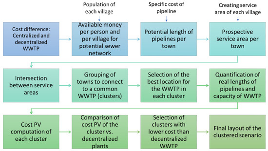
Figure 5.
Definition process of clusters.
Next, a prospective area (called service area) was created around each town using the service area command of the network analysis tool of ArcGIS Pro Version 2.7.3. [28], which indicated the initial maximum distance that a village could reach by building a trunk line along the roads (edges) (Figure 5).
Overlap between the service areas of different villages showed that these villages could potentially be connected to a common WWTP, thus forming a cluster (Figure 6).
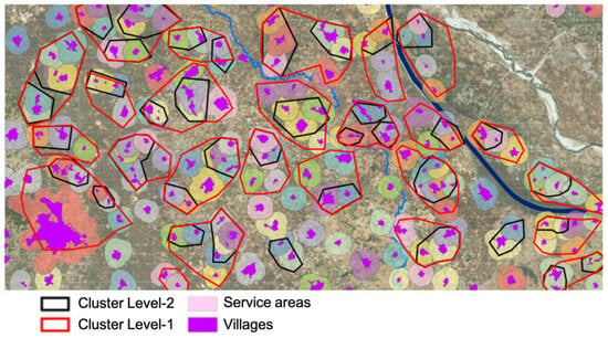
Figure 6.
Indicative service areas for clustering the towns.
Once a cluster had been identified (Figure 6), the WWTP location was defined for each cluster using the location-allocation tool. Next, the trunk-line network was created to estimate the actual size of the wastewater infrastructure, such as the trunk line and lifting stations. All costs were then calculated in the same way as in the other two scenarios (Figure 4). Finally, the net present value of the estimated costs was determined. After the economic assessment, the net present value of each cluster was compared to the net present values of the decentralized WWTP in individual villages. If the clusters showed lower costs compared to the decentralized scenario, the cluster was selected as more cost-efficient, whereas if the reverse was true, the decentralized treatment option was included in the scenario.
3. Results
3.1. Population and Villages in the Study Area
During the image classification process, the buildings in each village were identified. Based on the villages that could be identified on the map (85 out of 184) and cross-referenced with the census data, the average population per building was estimated to be 5.3 in 2021. Assuming this number for the remaining villages, the population for the entire study area (Figure 7) was estimated to be 218,241 in 2021. After applying the census projection, the projected population for 2036 was calculated as 391,324.
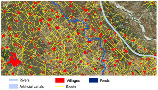
Figure 7.
Study area with data needed for the analysis.
Although there was a large city with about 65,000 inhabitants in the study area, more than 80% of the villages had less than 2500 inhabitants (Supplementary Table S2). The total length of the road network connecting the villages was about 1200 km.
3.2. Scenarios
In the decentralized scenario, all villages relied on individual WWTPs located within the village boundaries (Figure 7). This meant 185 WWTPs were considered for settlements of 50 to 65,000 inhabitants. The centralized scenario consisted of a centralized WWTP with a size of ca. 400,000 person equivalent (PE), a total pipeline network of 376 km, and 428 pumping stations of different sizes (Figure 8a). In the clustered scenario, 41 villages were grouped into 12 clusters. For the remaining 143 villages, the decentralized solution was more cost-efficient than any cluster (Figure 8b).
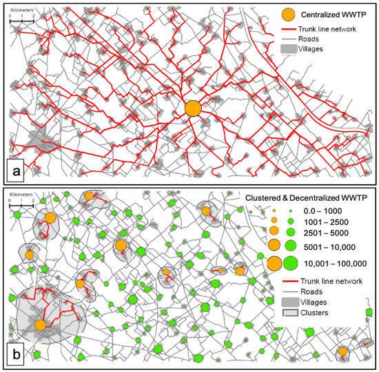
Figure 8.
Developed scenarios presented as (a) centralized and (b) clustered, including the layout of wastewater infrastructure.
In terms of population, 38% of the population was included in the clusters, leaving the remaining 62% for the decentralized solution. Figure 9 shows the net present value of the scenarios over the analysis period.
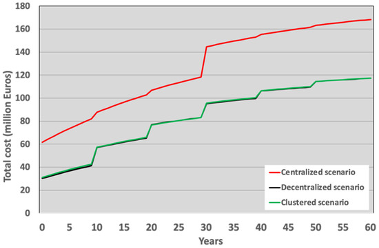
Figure 9.
Net present value (NPV) of the cost development over the analysis period.
The centralized scenario had the highest cost (EUR 168.35 million) throughout the assessment period, while the decentralized (EUR 118.42 million) and clustered (EUR 118.15 million) scenarios presented nearly similar behavior in terms of cost development (Figure 9 and Table 2). This was mainly because the construction of the optimized (clustered) scenario was based on the potential cost surplus generated by reducing the number of individual WWTPs through centralization. Regarding the composition of costs for the centralized scenario, 27% of the total cost was for the WWTP, 55% for the trunk-line network and 18% for lift stations (Table 2 and Figure 10).

Table 2.
Net present value of infrastructure costs over the analysis period of 60 years (in EUR millions).
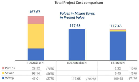
Figure 10.
Total project cost comparison (without land cost).
For the clustered scenario, almost 93% of the total cost was for WWTPs, while a fraction of the cost was dedicated to the trunk line and pumping stations (Table 2 and Figure 10). Regarding cost types, the investment cost (IC) for WWTPs was the lowest for all scenarios, ranging from 10% (centralized scenario) to 23% (decentralized scenario) (Table 2 and Supplementary Figure S3). The highest costs were associated with O&M and reinvestment (RIC) for the trunk-line network and pumping stations for the centralized scenario and WWTPs in the remaining two scenarios (Table 2 and Supplementary Figure S3).
4. Discussion
The development of the scenarios and economic assessment showed that the clustered scenario gave the best combination of decentralized and clustered WWTPs, provided that the costs were slightly lower than that of the decentralized scenario. That means the clustered scenario offered the level of centralization from an economic perspective in terms of both WWTP size and trunk-line network design. Since the development of the clustered scenario was based on optimization of the size of WWTPs and layout of the trunk-line network against the minimum cost threshold of the decentralized scenario, the two scenarios were nearly similar in terms of cost, showing a difference of only EUR 0.27 million. In other words, the network of the clustered scenario was expanded without surpassing the cost of the decentralized option. Meanwhile, the centralized scenario showed a cost difference of around EUR 50 million over the analysis period compared to the other two scenarios.
The results of the study showed that the total costs of a scenario were strongly dependent on the complexity of the trunk-line network, particularly the length of the trunk-line network and number of pumping stations involved. Similar conclusions were drawn by Khurelbaatar et al. [3], who investigated wastewater management options within settlements. Maurer et al. [32] also reported a similar cost constellation. In the centralized scenario in this study, the WWTP accounted for only 9% of the investment cost, while in the long run, the cost of the WWTP increased to about 27% of the total costs. Similar results have been reported by Maurer et al. [32] and Shapiro and Rogers [33].
Aubron et al. [34] conducted a similar analysis for a region with rural and peri-urban areas by considering two scenarios: decentralized and clustered. While the decentralized scenario was developed in a similar manner to the present study, the clustered scenario was developed manually. Their results showed that the decentralized scenario was preferred due to the involvement of a series of pumping stations and trunk-line networks for the clustered scenario. This might have resulted from the manual development of the clustered scenario, a process that was systematically approached within the current study. Although a number of studies have addressed the same issue, they were conducted on a much smaller scale [3,17,18,19,35]. Conversely, on a much larger scale, Hutton and Varughese [20] provided country-level cost estimates to fulfill SDG#6. Our study aimed to provide a systematic analysis method that could help scale up wastewater management analysis at a regional level, bridging the gap between local-scale analysis tools [3,17,18] and country-scale cost estimates [20].
Similar to Khurelbaatar et al. [3], scenario development in the present study was conducted with minimum input data to overcome the problem of data scarcity globally, especially in rural regions. In this way, we explored the possibility of developing plausible scenarios for wastewater management without first conducting extensive data collection, relying mainly on globally available data.
In this study, only three scenarios were developed. The main objective was to develop solutions for regional wastewater management by finding optimized approaches between fully centralized and fully decentralized solutions. However, in combination with other tools like ALLOWS, many more scenarios could be developed, such as an on-site solution within each village. Also, additional wastewater treatment technologies, such as constructed wetlands [22], could be included in the scenario development, making the analysis more complex. In conjunction with different treatment technologies, the issue of the reuse of treated effluent could be addressed in the scenarios. Particularly in rural regions, wastewater is a viable resource for agriculture [36], and a higher level of decentralization offers greater opportunities to maximize the benefits of reuse.
On the contrary, centralized wastewater treatment plants are less prone to fluctuations in quality and quantity of wastewater influent, which allows a stable treatment performance and, hence, an important point towards environmental protection. In addition, the quality of the treated effluent often can be better monitored and hence managed compared to the smaller wastewater treatment plants [37]. These values can be added to the analysis to rank the scenarios according to the cost and other factors.
In the current study, the development of the wastewater infrastructure and hence the wastewater management scenarios and their optimization were the main focus, so the economic analysis only included the cost comparison of the scenarios. However, this approach can be used to calculate the costs with higher accuracy and can also include aspects like sensitivity analysis and cost-benefit ratio to focus more on the uncertainties of the solutions. The same applies to the general data-related outcome of the approach; as the level of detail increases, more realistic results can be achieved. With detailed input data, the accuracy of such analysis can be increased, which will narrow the range of uncertainty. Since the approach is dealing with regions with low data availability, cost data must be handled carefully. The scenarios and their rankings are especially highly dependent on the cost assumptions and cost data. This can be handled by using some local cost range, e.g., increased or decreased cost for sewer network depending on the type of soil or by relying on the global cost database [3,20].
The current study involved a terrain that is relatively flat, thus enabling a simplified assumption and estimation of pumping stations and gravity pipe networks. However, for regions with hilly and mountainous terrains, a more sophisticated approach to developing the trunk-line networks must be considered, including, e.g., pressurized and/or vacuum pipe networks.
Once the methodology is manually set, scenario development and optimization could be automated so that the analysis could cover even larger areas [38] than that of the current study. The processes that could be automated in scenario development include dimensioning the trunk-line network, estimating the distance between pumping stations, and identifying and creating clusters and cluster networks.
This approach establishes the basis for a scenario comparison using multi-criteria analysis. Other criteria might include social acceptance, reuse priority, risk assessment, desired quality of the treated effluent, environmental protection, etc. since the cost is not the only deciding factor when planning and implementing wastewater infrastructure. Overall, the approach is designed to support the decision-making process by providing preliminary planning and scenario development rather than detailed planning.
5. Conclusions
This study presented a novel approach that can be used to assess which type of wastewater management system is the most appropriate from a regional perspective, building on the recurring discussion that no single answer meets the needs of all settlements. The study region represents a typical rural region characterized by a lack of data availability. This study explains the step-by-step methodology to generate the input data and to carry out preliminary planning, scenario development, scenario optimization, and cost analysis of wastewater management solutions in the region. Three regional wastewater management scenarios were developed: centralized, decentralized, and optimized (clustered). Based on the cost assessment, the centralized scenario showed the highest cost, while the costs associated with decentralized and optimized scenarios were nearly the same.
The study focused on a data-scarce rural region in order to enable transferability to implement in other regions. An important contribution was the scale of application, as previous similar studies have mainly focused on small areas or portions of settlements, especially in urban areas or growing urban conglomerates.
As many reports highlight the importance of the preliminary planning stage, this approach is developed with the intention of being used as a preliminary planning and decision support tool for local and international decision-makers and stakeholders. Finally, this approach may aid global wastewater management by estimating and optimizing infrastructure costs needed to fulfill SDG#6 in rural regions.
Supplementary Materials
The following supporting information can be downloaded at: https://www.mdpi.com/article/10.3390/w16050694/s1, Supplementary Table S1: Workflow for the image classification process using the classification Wizard ArcMap; Supplementary Table S2: Population of the villages; Supplementary Figure S1: Division of the study area in sub-areas to facilitate the classification process; Supplementary Figure S2: Training samples in one of the villages of the study area; Supplementary Table S3: Peak factor for the various population sizes; Supplementary Table S4: Cost of the WWTP (SBR) in EUR; Supplementary Table S5: Cost of trunk lines; Supplementary Table S6: Cost of lifting stations (max. pump head 5 m); Supplementary Table S7: Parameters of cost calculation; Supplementary Table S8: Infrastructure lifespan in the cost estimation; Supplementary Table S9: Assumptions in land cost estimation; Supplementary Figure S3: Participation per type of cost and infrastructure.
Author Contributions
Conceptualization, M.v.A., T.A., G.K. and J.F.; methodology, G.K.; formal analysis, S.P.R.R.; supervision, G.K.; data curation, G.K., S.P.R.R. and N.K.; writing—original draft preparation, G.K. and S.P.R.R.; writing—review and editing, K.Z.R. and M.B.; project administration, N.K. and R.A.M.; funding acquisition, T.A. and N.K. All authors have read and agreed to the published version of the manuscript.
Funding
This research was funded by the European Union through its Horizon 2020 research and innovation program, grant number 821410 and the Department of Science and Technology in India through the DST/IMRCD/India-EU Water Call2—PAVITR project.
Data Availability Statement
The data presented in this study are available on request from the corresponding author, K.Z.R., khaja.rahman@ufz.de.
Acknowledgments
The authors are grateful to Julian David Reyes Silva, a research associate at Technical University Dresden, Germany, and Moritz Sanne at Helmholtz Centre for Environmental Research (UFZ), Leipzig, Germany, for their valuable support and insights at different stages of this study. The authors’ appreciation also goes to the Research Fellows at the Aligarh Muslim University (AMU) for their literature survey and for providing local data from India for this study.
Conflicts of Interest
The authors declare no conflicts of interest. The funders had no role in the design of the study; in the collection, analyses, or interpretation of data; in the writing of the manuscript; or in the decision to publish the results.
References
- UN. Transforming Our World: The 2030 Agenda for Sustainable Development (A/RES/70/1); United Nations: New York, NY, USA, 2015. [Google Scholar]
- UN. SDG 6 Synthesis Report 2018 on Water and Sanitation; United Nations: New York, NY, USA, 2018. [Google Scholar] [CrossRef]
- Khurelbaatar, G.; Al Marzuqi, B.; Van Afferden, M.; Muller, R.A.; Friesen, J. Data reduced method for cost comparison of wastewater management scenarios—Case study for two settlements in Jordan and Oman. Front. Environ. Sci. 2021, 9, 137. [Google Scholar] [CrossRef]
- Gregory, R.; Failing, L.; Harstone, M.; Long, G.; McDaniels, T.; Ohlson, D. Structured Decision Making: A Practical Guide to Environmental Management Choices; John Wiley & Sons, Inc.: Hoboken, NJ, USA, 2012. [Google Scholar] [CrossRef]
- UNICEF; WHO. State of the World’s Sanitation: An Urgent Call to Transform Sanitation for Better Health, Environments, Economies and Societies; Programme Division/WASH: New York, NY, USA, 2021. [Google Scholar]
- UN. The Sustainable Development Goal 6 Global Acceleration Framework; United Nations, UN-Water: Geneva, Switzerland, 2020. [Google Scholar]
- Pramit, V.; Raghubanshi, A.S. Urban sustainability indicators: Challenges and opportunities. Ecol. Indic. 2018, 93, 282–291. [Google Scholar] [CrossRef]
- Graham, J.; Gurian, P.; Corella-Barud, V.; Avitia-Diaz, R. Peri-urbanization and in-home environmental health risks: The side effects of planned and unplanned growth. Int. J. Hyg. Environ. Health 2004, 207, 447–454. [Google Scholar] [CrossRef] [PubMed]
- Lüthi, C.; McConville, J.; Kvarnström, E. Community-based approaches for addressing the urban sanitation challenges. Int. J. Urban Sustain. Dev. 2012, 1, 49–63. [Google Scholar] [CrossRef]
- Lüthi, C.; Kraemer, S. User perceptions of participatory planning in urban environmental sanitation. J. Water Sanit. Hyg. Dev. 2012, 2, 157–167. [Google Scholar] [CrossRef]
- Gijzen, H.J.; Bijlsma, M. Technical Measures. In Strategy Options for Sewage Management to Protect the Marine Environment; UNEP/GPA: The Hague, The Netherlands, 2020; pp. 33–58. [Google Scholar]
- Li, W.; Zheng, T.; Ma, Y.; Liu, J. Analysis of suitable private-secondary-main sewer diameters in rural areas based on cost model and hydraulic calculation. J. Environ. Manag. 2021, 281, 111925. [Google Scholar] [CrossRef] [PubMed]
- Maurer, M.; Rothenberger, D.; Larsen, T.A. Decentralised wastewater treatment technologies from a national perspective: At what cost are they competitive? Water Sci. Technol. Water Supply 2006, 5, 145–154. [Google Scholar] [CrossRef]
- Maurer, M.; Herlyn, A. Zustand, Kosten und Investitionsbedarf der Schweizerischen Abwasserentsorgung; Eawag: Düdendorf, Switzerland, 2006. (In German) [Google Scholar]
- Clark, R. Optimum Scale for Urban Water Systems; Tech. Rep. 5 in the Water Sustainability in Urban Areas Series; Water Resources Group, Department of Environment and Natural Resources: San Antonio, TX, USA, 1997.
- World Health Organization; Regional Office for Europe & United Nations Economic Commission for Europe. Sanitation in the Pan-European Region: 12–13 February 2019, Bonn, Germany: Meeting Report. Available online: https://apps.who.int/iris/handle/10665/346914 (accessed on 7 June 2021).
- van Afferden, M.; Cardona, J.A.; Lee, M.Y.; Subah, A.; Müller, R.A. A new approach to implementing decentralized wastewater treatment concepts. Water Sci. Technol. 2015, 72, 1923–1930. [Google Scholar] [CrossRef] [PubMed]
- Eggimann, S.; Truffer, B.; Maurer, M. To Connect or not to connect? Modelling the optimal degree of centralisation for wastewater infrastructures. Water Res. 2015, 84, 218–231. [Google Scholar] [CrossRef]
- Huang, Y.; Wu, L.; Li, P.; Li, N.; He, Y. What’s the cost-effective pattern for rural wastewater treatment? J. Environ. Manag. 2022, 303, 114226. [Google Scholar] [CrossRef]
- Hutton, G.; Varughese, M. The Costs of Meeting the 2030 Sustainable Development Goal Targets on Drinking Water, Sanitation, and Hygiene; World Bank Group, Water and Sanitation Program: Washington, DC, USA, 2016. [Google Scholar] [CrossRef]
- Kamal, A.S.M.; Goyer, K.; Koottatep, T.; Amin, A.T.M.N. Domestic wastewater management in South and Southeast Asia: The potential benefits of a decentralised approach. Urban Water J. 2008, 5, 345–354. [Google Scholar] [CrossRef]
- Hänel, M.; Khurelbaatar, G.; Jespersen, E.; Upadhyay, A.; Acosta, A.; Khalil, N.; Brix, H.; Arias, C.A. Application Potential of Wastewater Fertigated Short Rotation Coppice Systems in a Selected Region (Aligarh, UP, India). Recycling 2023, 8, 75. [Google Scholar] [CrossRef]
- Dwivedi, S.; Mishra, S.; Tripathi, R.D. Ganga water pollution: A potential health threat to inhabitants of Ganga basin. Environ. Int. 2018, 117, 327–338. [Google Scholar] [CrossRef] [PubMed]
- MHFW. Population Projections for India and States 2011–2036; Ministry of Health & Family Welfare: New Delhi, India, 2019.
- Alaska Satellite Facility, ASF Radiometrically Terrain Corrected ALOS PALSAR Products, Revision 1.2, 2015. Available online: https://asf.alaska.edu/wp-content/uploads/2019/03/rtc_product_guide_v1.2.pdf (accessed on 7 June 2021).
- Microsoft. Bing Maps. 2018. Available online: https://www.bing.com/maps?osid=e102f622-c8c2-4e5e-aa26 (accessed on 7 June 2021).
- Ettenauer, K. Adaption of Cost Functions of Water and Sanitation Technologies for India. Master’s Thesis, Institute of Sanitary Engineering, University of Natural Resources and Life Sciences (BOKU), Vienna, Austria, 2021. [Google Scholar]
- ESRI. ArcGIS Pro; Version 2.7.3; ESRI: Redlands, CA, USA, 2020. [Google Scholar]
- CPHEEO—Central Public Health & Environmental Engineering Organisation; Ministry of Housing and Urban Affairs; Government of India. Obtenido de Manual on Sewerage and Sewage Treatment Systems. Part A: Engineering. Chapter 3. Design and Construction of Sewers. 2013. Available online: http://cpheeo.gov.in/cms/manual-on-sewerage-and-sewage-treatment.php (accessed on 7 June 2021).
- Sperling, M.v.; de Lemos Chernicaro, C.A. Biological Wastewater Treatment in Warm Climate Regions; IWA Publishing: London, UK, 2005; Volume 1, ISBN 1843390027. [Google Scholar]
- DWA. Deutsche Vereinigung für Wasserwirtschaft, Abwasser und Abfall e.V. Dynamic Cost Comparison Calculations for Selecting Least-Cost Projects in Water Supply and Wastewater Disposal DCCC—Guidelines for Project Designers; The German Association for Water, Wastewater and Waste (DWA): Hennef, Germany, 2011; ISBN 9783941897052. [Google Scholar]
- Maurer, M.; Wolfram, M.; Anja, H. Factors affecting economies of scale in combined sewer systems. Water Sci. Technol. 2010, 62, 36–41. [Google Scholar] [CrossRef] [PubMed]
- Shapiro, M.; Rogers, P. Analyzing the impact of land use on sewer service area planning. J. Am. Water Resour. Assoc. 1978, 14, 1340–1356. [Google Scholar] [CrossRef]
- Aubron, T.; van Afferden, M.; Khurelbaatar, G.; Müller, R. Development and testing of a GIS-based planning tool for creating decentralized sanitation scenarios. Terr. Environ. Sci. 2019, 2, 125–157. [Google Scholar]
- CLARA TOOL. BOKU University Vienna, BIOZAUL S.L., EcoSan Club Consulting OG, CLARA Simplified Planning Tool V 1.5. User Manual, 2014. Available online: https://sswm.info/sites/default/files/reference_attachments/CASIELLES%20et%20al%202014%20CLARA%20SPT.pdf (accessed on 7 June 2021).
- Jamwal, P.; Thomas, B.K.; Lele, S.; Srinivasan, V. Addressing water stress through wastewater reuse: Complexities and challenges in Bangalore. In Proceedings of the 5th Global Forum on Urban Resilience & Adaptation, Bonn, Germany, 29–31 May 2014; Available online: http://hdl.handle.net/10625/53874 (accessed on 7 June 2021).
- Bunce, J.T.; Graham, D.W. A Simple Approach to Predicting the Reliability of Small Wastewater Treatment Plants. Water 2019, 11, 2397. [Google Scholar] [CrossRef]
- Friesen, J.; Sanne, M.; Khurelbaatar, G.; van Afferden, M. “OCTOPUS” principle reduces wastewater management costs through network optimization and clustering. One Earth 2023, 6, 1227–1234. [Google Scholar] [CrossRef]
Disclaimer/Publisher’s Note: The statements, opinions and data contained in all publications are solely those of the individual author(s) and contributor(s) and not of MDPI and/or the editor(s). MDPI and/or the editor(s) disclaim responsibility for any injury to people or property resulting from any ideas, methods, instructions or products referred to in the content. |
© 2024 by the authors. Licensee MDPI, Basel, Switzerland. This article is an open access article distributed under the terms and conditions of the Creative Commons Attribution (CC BY) license (https://creativecommons.org/licenses/by/4.0/).