Article

Water Renewal Time in Lakes with Transformed Water Distribution in the Catchment Areas

1
Department of Hydrology and Climatology, Maria Curie-Skłodowska University, Aleja Kraśnicka 2 cd, 20-718 Lublin, Poland
2
Department of Hydrobiology and Protection of Ecosystems, University of Life Sciences, 13 Akademicka St., 20-950 Lublin, Poland
*
Author to whom correspondence should be addressed.
Water 2024, 16(3), 384; https://doi.org/10.3390/w16030384
Submission received: 8 December 2023 / Revised: 20 January 2024 / Accepted: 22 January 2024 / Published: 24 January 2024

Abstract

:
Water exchange in lake basins is a very important process in regulating the health of the aquatic environment, e.g., by shaping algal blooms. Thus, knowledge of the process is also required to develop management strategies. The paper presents a dynamic of water renewal time in the Uściwierz chain of lakes, in which the natural hydrological connectivity of the catchment areas has been altered due to human impact. Calculations of water renewal were limited to the part of the lake basin corresponding to the active (dynamic) retention layer. A comparative analysis of the rate of potential water renewal, based on the structure difference index, was used as an indicator of the degree of anthropogenic transformation of water distribution in the lake catchments. The smallest differences in the structure of the water renewal rate between the neighboring lakes in the chain system were observed in the cold period, and the largest differences were observed in the warm period. The results showed that the shorter the timescale (5-day period), the higher the similarity in the structure of the water renewal rate between the lakes. Very large differences between the structure of the potential water renewal rate in Lakes Uściwierz and Bikcze indicated a significant transformation of the water cycle down the lake chain. The water renewal rate proved to be a good indicator of the degree of anthropogenic transformation in the catchments located in close proximity.

1. Introduction

Evaluating water exchange processes in lakes is an important issue [1]. It reflects catchment hydrology and indicates flow paths and storage, as well as lakes’ water quality, as biogeochemical reactions are time-dependent [2,3]. Water renewal provides information about the proportions and dynamics of ions dissolved in the lake waters, as well as the intensity of dilution and concentration processes in the aquatic system [4,5]. The intensity of water exchange processes controls both the ion concentration and the accumulative capacity of a water body [6,7,8]. Therefore, it has been recognized by the European Union (EU) in the European Water Framework Directive 2000/60/CE [9] as an important hydro-morphological indicator of the water quality of lakes. Two first-order hydrodynamic processes of water transport in lakes are water residence time and flushing time [10]. Residence time determines both mixing and transport processes and the time available for biochemical transformations [11]. Flushing time is considered to be a strong predictor of phosphorous retention in lakes [12,13]. There are many ways to estimate water exchange ratios, such as hydrodynamic models [14], traces [15], or measured values of water balance elements.
Calculations of either residence time or flushing time are based on the following two assumptions: (i) the lake is formed as a stretch of river; thus, a uniform flow is observed, and (ii) the lake is considered to be a continuously stirred tank reactor (CSTR) [16]. These assumptions bring about other issues. Seasonal flow variations in lakes’ tributaries are often observed; hence, the water transit time through lakes may vary considerably over time [17]. These calculations are often based on the assumption that lake volume is constant throughout the year [18], yet in these highly dynamic systems, many seasonal and short-term fluctuations in inflow and outflow rates (and thereby lake volume) are observed [19]. Moreover, continuous stirring may only be observed in shallow lakes [20], whereas deep lakes become stratified [21]. Consequently, new methods of measuring water exchange have been introduced, both experimental [22] and theoretical, to calculate more realistic water renewal times. It has been noted that water exchange calculations in deep lakes should be limited to the mean epilimnion [23,24]. This is due to the fact that in stratified lakes, both inflow and outflow influence a narrow range of depths [25]. We address this problem in our approach to calculating renewal time.
This paper presents a new concept of water exchange estimation that has been introduced to analyze hydrologic and anthropogenic transformations in the Uściwierz chain of lakes, located in Eastern Poland. It is very important to accurately assess renewal time because it is regarded as a major factor in influencing the health of aquatic systems, and knowledge of water exchange is required to develop management strategies [26,27]. Moreover, managing water exchange processes can be used as a means of restoration to reduce cyanobacterial blooms and other environmental problems faced by lakes [28].
The main objective of the study was to determine the impact of the man-made transformations of surface water distribution on the rate of water exchange in the Uściwierz Lake catchment system. We hypothesized that the rate of potential water renewal was a factor indicating the degree of anthropogenic transformation of water conditions. We also assumed that the adjacent location of each lake in the chain system would lead to similarities in terms of water exchange processes, taking into account typical fluvial inertia (varying in space).

2. Materials and Methods

2.1. Study Site

The lakes under study are a part of the Łęczna-Włodawa Lake District, located in Eastern Poland. The Uciwierz Lake system consists of four shallow water bodies located in the southern part of the Lake District. Under natural conditions, the Uściwierz chain of lakes functioned as a single catchment and lake system [29], in which downstream lakes were supplied with water after exceeding the retention capacity of the basins and the direct catchment areas of the chain lakes. The low diversity of topographic relief and the need to drain excess water (especially in spring after the thaw period) led to the digging of drainage ditches in the 1960s. The dense drainage system of deep ditches has effectively changed the natural distribution of the waters and the lakes’ functioning in both quantitative and qualitative terms [30]. A wide peat bog zone adjacent to the Uściwierz Lakes is a reservoir of water that supplies the lake basins [31]. It is rare for the drainage ditches in this system to touch the lake basin; they most often drain an adjacent area, indirectly affecting the natural changes in the lakes’ water levels. Such hydrotechnical solutions rendered it extremely difficult to balance surface and shallow subsurface water resources in the whole cascade. It should be assumed that the period of surplus water in the upstream lake was the moment when the input to the lower lake increased. Similarly, the lower lake, after exceeding its retention capacity, began feeding the next downstream lake in the chain system. This natural mechanism of water allocation is characterized by certain inertia that results from the catchment features (geological structure, relief, land use, etc.). Originally, the Uściewierz chain of lakes was only drained to the west of the Piwonia River (Wieprz River reaches), but due to anthropogenic transformations of the water outflow, the upper part of the system now releases some of the water to the north, to the Włodawka River (a tributary of the Bug). Therefore, determining the degree of anthropogenic transformation of the entire Uściewierz chain of lakes remains a fundamental problem.
The lakes were characterized by alternating variations in morphometric characteristics (Figure 1).
The surface area, volume, and relative depth of an uppermost lake were greater than in a lower (second-order) lake. Similarly, a third-order lake was larger than the next downstream lake in the chain. All of the lakes had flat-bottomed basins of relatively shallow depth (Table 1).
Uściwierz Lake had the largest area. Human impacts in the catchments have led to a greater number of drainage ditches, modifying surface water distribution. However, the groundwater table, which is harmonious with the topographic surface, has not been altered by human activity [29,32].
The direction of groundwater runoff is in line with the inclination towards the drainage base, the Wieprz River valley in the west. The catchment areas of the Uściewierz Lakes are small, and the watersheds are low, usually zonal (difficult to determine, covering a wide belt). Lake Bikcze, the lowest lake in the chain, was embanked to turn it into a storage reservoir in the 1960s. However, apart from cutting off the basin from its catchment (the embankment system), this role was not fulfilled, and hydrological conditions (both inlet and outlet) significantly influence lake water quality [33]. For this reason, holiday homes have not been developed in this lake’s catchment. However, the other lakes are constantly under significant pressure from tourism in the summer.
Lakes’ inflows and outflows showed inter-annual variation in terms of discharge. The highest values were observed in late winter–early spring, whereas the lowest were observed in summer (Table 2).
The hydrometeorological conditions (precipitation and discharge) of the study period were close to the average values for the area. The annual sum (from August 17 to July 18) of precipitation amounted to 490.3 mm, whereas the average annual precipitation in the Bezek gauging station (data from the Polish Institute of Meteorology and Water Management) amounted to 498 mm.

2.2. Hydrological and Limnological Measurements

The average daily water flow rates in all the streams feeding or draining the studied lakes were used to analyze the rate of potential water renewal. The water levels of both streams and lakes were measured using automatic ultrasound gauges. The average daily water level was an arithmetic average of 48 measurements (every 30 min). Discharge, corresponding to average daily water levels, was measured with a Valeport 801 EM flow meter.
Calculations of water exchange were conducted with reference to the active (dynamic) retention layer (R), corresponding to the lake basin volume and equal to the difference in extreme values (maximum and minimum lake volume in each month of the study period):
R = V m a x V m i n
The rate of water renewal was calculated by taking into account the elements of horizontal water exchange, inflow (I), and outflow (O). Effective water exchange was also considered, corresponding to the principle of equivalence of the quantity of the inflow and outflow in the lake basin (I = O). Only under such conditions may a portion of drained water be replaced by the same volume of fresh inflowing water; thus, the water is renewed. When I > O, an increase in water level (and lake volume) is observed, which nevertheless does not fully implement potential water renewal (as the surplus between inflow and outflow constitutes basin retention, not exchange). Similarly, when I < O, a decrease in water level occurs, which also means that not all of the inflowing and draining water participates in the exchange process. A lack of equivalence of water inflow and outflow may occur due to the presence of other forms of water input and output, e.g., precipitation or evaporation.
Taking into account the aforementioned conditions, an index of potential water renewal rate was proposed based on the ratio of the radii of a cylinder with a volume equal to the calculated active retention of the lake basin (R) and the radii of a cylinder with a volume equal to the daily inflow/outflow (r). The height of the cylinders was deemed equal to the thickness of the active retention zone. The actual water renewal value obtained was converted into a potential value, determining the time (in days) of total water renewal in the volume of the active retention layer.
W r = R r = V L h V I / O h
where R and r—radius of a cylinder with a volume equal to the active retention of the lake and the volume of daily inflow/outflow; VL—lake volume; VI/O—the volume of daily inflow/outflow; h—the height of the cylinders.
The volumes of the Uściwierz Lakes were obtained from bathymetric plans conducted on ice in the winter of 2017 and 2018. The depths were measured using a weight probe, while the locations of points were marked using a GPS receiver under clear sky conditions. In the larger lakes (Uściwierz, Sumin, and Bikcze Lakes), the depth was sampled every 200 m; in the smaller lakes (Lake Rotcze), every 100 m, the points were evenly distributed to cover both the deepest part of the lake basin and the near-shore areas. All of the bathymetric calculations were made using Didger 5.0 and Surfer 25 computer programs.

2.3. Statistical Analyses

A statistical distribution series of water renewal rates was used to calculate the structure difference index (SDI). The abundance of the series, determined by the range, is attained from the average time of water inflow (in days) between the farthest lakes in the Uściwierz chain lake system. The average time amounted to five days. To validate this hydrologic approach, wider intervals (10-day period and monthly) were also tested.
The SDI was calculated as follows:
S D I = i = 1 k min ( w 1 i , w 2 i )
where:
w 1 i , , w 2 i = n i n
w1i, w2i—structure indices of the first and second populations, respectively; ni—an abundance of the interval; n—population abundance.
On each occasion, two neighboring lakes were compared: Sumin and Rotcze Lakes (S/R); Rotcze and Uściwierz Lakes (R/U); and Uściwierz and Bikcze Lakes (U/B).
The abundance distribution characterizing the average rate of water renewal in the lake basin did not contain empty compartments. The SDI values ranged from 0 to 1. The closer the value was to zero, the less different the compared structures were in terms of the feature being examined. The SDI values ranging from 0 to 0.1 indicated insignificant differences (the examined lakes differ very slightly due to the structure of the water renewal rate).
The total role of differences in the structure of the water renewal rate was presented using Ferret’s triangle. For each time-scale (month, 10-day period, and 5-day period), a relative share of the SDI value of the pairs of compared lakes (S/R, R/U, and U/B) was determined. The sum of the SDI values of the three compared pairs of lakes accounted for 100%. The concentration of points in the apex zone corresponding to the compared adjacent lakes indicated significant differences in the structure of water renewal resulting from human pressure (changes in water distribution).
The analysis of water level variability was carried out using the coefficient of variation Cv, expressed by the ratio of the standard deviation “σ” to the average annual water level “ H ¯ ”. This is a precise and objective measure of variability.
C v = σ H ¯ = ( H i H ¯ ) 2 n 1 H ¯

3. Results

The temporal variation in the lakes’ area and volume during the study period is presented in Table 3.
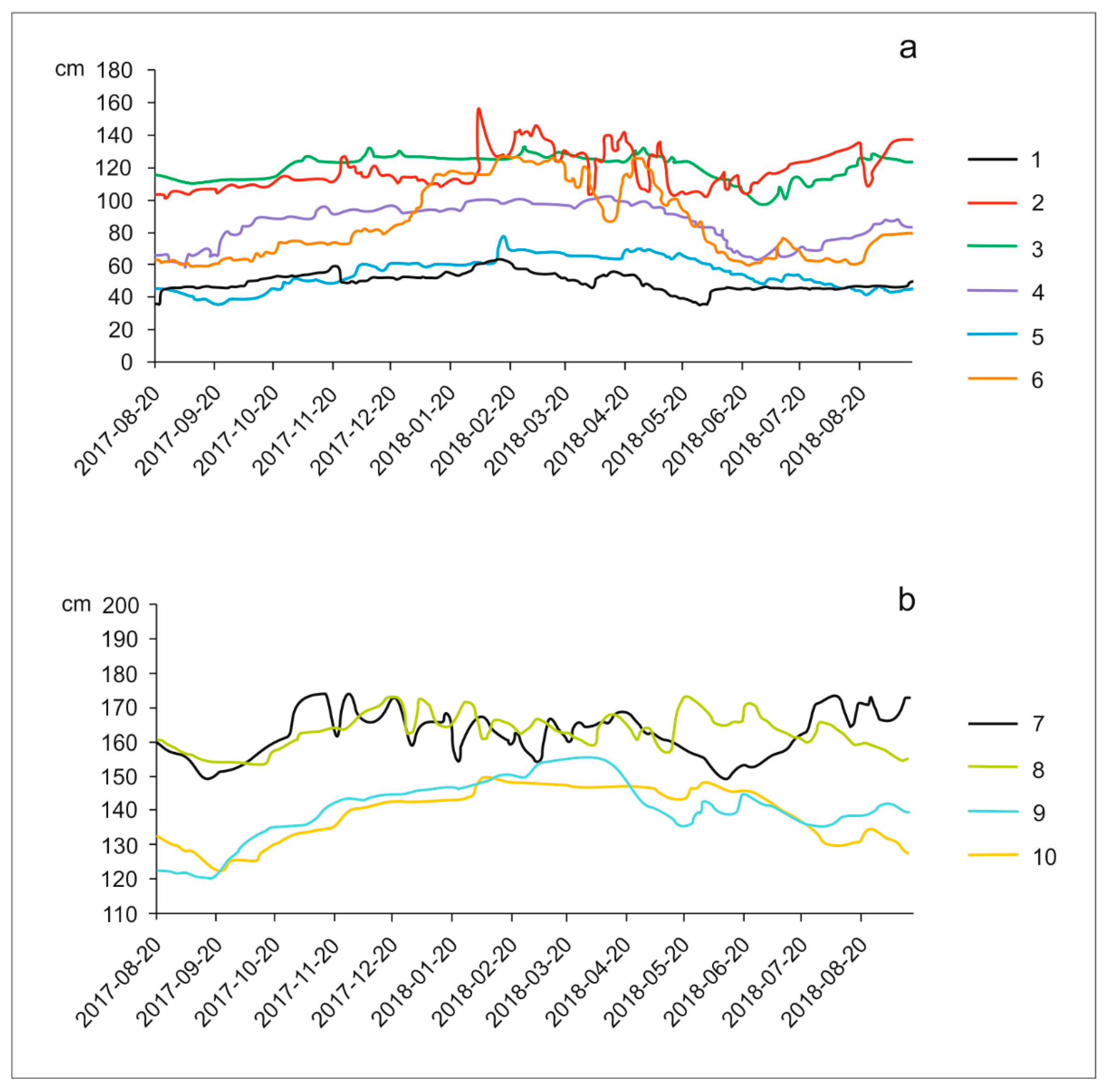
The water level dynamics of both inlets and outlets showed clear seasonality (Figure 2a). In late winter and spring, an increase could be seen in water levels and, therefore, in the corresponding discharges of streams.
Water level dynamics, expressed by the coefficient of variation “cv”, ranged in streams from 6.8% at the inflow of Lake Rotcze to 26.1% at the outflow of Lake Sumin to the north. In lakes, the highest value of the coefficient of variation (6.6%) was observed in Lake Bikcze, which is located downstream, whereas the lowest Cv value (4.4%) was found in Lake Rotcze. In general, the variability in water levels and rate flows varied spatially. The lakes’ water levels, corresponding to their storage capacities, were more stable than those of the streams (Figure 2b). Similar to the streams, the water levels of the lakes also showed seasonal variability. In general, the lowest water stages occurred at the turn of summer and autumn (from August to October), while the highest stages were observed in early spring (from March to May). Hydrographs of the water levels of the Lakes Sumin and Rotcze, as well as Uściwierz and Bikcze, showed similarity in the course.
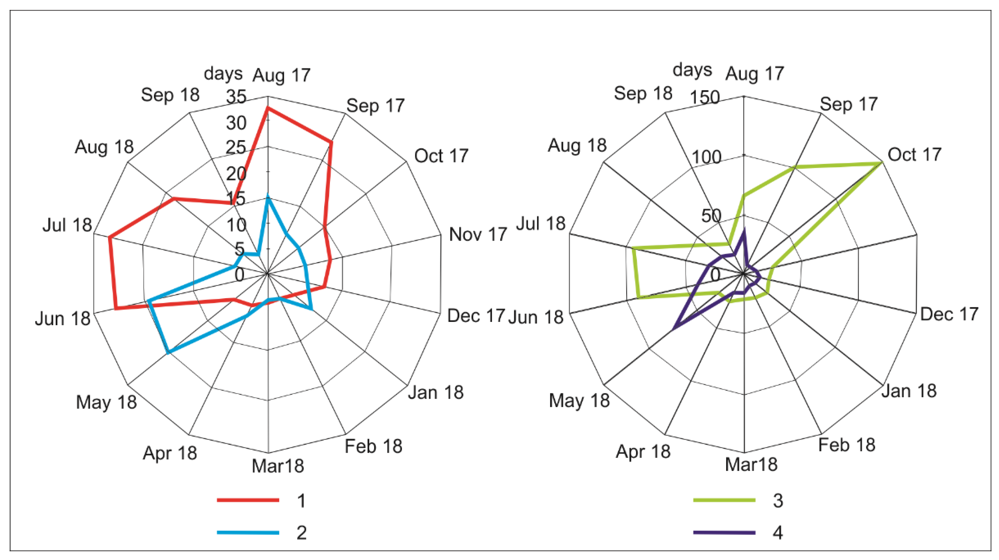
The rates of potential water renewal differed considerably in the study lakes (Figure 3).
In Lake Sumin, the time of water exchange ranged from four to 39 days and was the most stable among the studied lakes. Water renewal in Lake Rotcze was the least stable, taking from two to 386 days. Lakes Uściwierz and Bikcze exhibited a similar exchange rate during the study period, from three to 149 days and from one to 144 days, respectively. In the case of Lakes Sumin and Rotcze, the longest time of water exchange occurred in the early autumn of 2017 and the summer of 2018, while in the case of Uściwierz and Bikcze, extremes occurred about a month earlier (Figure 3).
The smallest differences in the structure of the water renewal rate (SDI) between the neighboring lakes in the chain system (regardless of the time interval) were observed in the cold period (from November to April), while the largest differences were seen in the warm period (from May to August). The results revealed that the shorter the timescale (pentads), the higher the similarity in the structure of the water renewal rate between neighboring lakes (Table 4).
When comparing monthly periods, a high degree of similarity in the renewal rate structure was recorded in about 50% of the observations. For five-day periods, the level of similarity increased to approximately 80% (Table 3). Regardless of the timescale, an increase in SDI values downstream in the chain of lakes was observed (Figure 4). All of the results calculated for longer periods (months and 10 days) were located in the central part of Ferret’s triangle, while in the case of five-day periods, an increase in point dispersion occurred. The higher dispersion (the highest SDI) of the water renewal rate was observed when the Lakes Bikcze and Uściwierz were compared (Figure 4).

4. Discussion

In the Uściwierz chain of lakes, the quantity of river supply (quick flow) was found to be of considerable interpretative importance. Due to the low topographic relief of the catchment areas and the groundwater table that reflects the shape of the topographic surface [34], the groundwater recharge role, which equalizes the storage capacity of lake basins, is modified by the surface runoff. The highest dynamic of the streams’ water levels and discharges in winter has been previously described in the Łęczna-Włodawa Lake District [35]. In winter, in the lake catchment systems of the Polesie region, which are located in close vicinity to the Cretaceous hummocks (Garbatówka Hummock in the case of study lakes), intensive groundwater recharge, as well as mid-winter thaws and snowmelt, can be observed [36]. High-flow events due to thaws and snowmelt are rather common in the temperate climatic zone in general [37]. Water level inter-annual fluctuations were found to be rather typical in the Łęczna-Włodawa Lake District and to be the result of both precipitation and river supply [38]. The similarity of the hydrographs in pairs—Rotcze and Sumin Lakes, as well as Uściwierz and Bikcze Lakes—might be related to their distance from the carbonate Garbatówka hummock. Water exchange in lakes is a dynamic process and often shows seasonal variations [39,40,41]. Inter-annual variability and the month of the extreme value occurrence were similar to the fluctuation of flushing time described by Ferencz [32], calculated for the Rotcze and Sumin Lakes. This suggests that the hydrological conditions of the study area were close to average. As mentioned previously, the amount of atmospheric input was typical for average conditions. The water exchange ratio is commonly used as a water quality indicator [42], but it may also be a good indicator of the conditions (modifications) of lake catchment environments. In lakes in a chain, the interdependence of phenomena determined by the water input (such as water level fluctuations, flushing time rate, etc.) is usually observed [43]. Therefore, under natural or quasi-natural conditions, such lakes should alternately feed and drain the lake basins located upstream and downstream of them. With regard to the Sumin and Rotcze Lakes, this process has been described by Ferencz and Dawidek [44]. Taking into account the delay in water input between the lakes in the chain, the process of water exchange, especially the water volume corresponding to the active retention capacity of the basin, should be similar in all of the lakes. The high level of hydrological activity in the catchment intensifies the process of equivalent water renewal. This is confirmed by the example of Lake Sumin, whose water renewal rate was the most stable in the study period. It was the only water body in the chain of lakes with one inflow and two outflows. On the other hand, the highest variability of potential water renewal has occurred in Lake Rotcze, where surface input and output of water have been impeded. According to previous studies [45], sensitivity to short-term variations in flushing is related to the lakes’ morphometry (area and volume). Thus, Uściwierz is the only lake in the chain that may be considered relatively insensitive to water exchange fluctuations. The SDI values of the potential water renewal rate of the lakes varied across both time and space. The timescale of interest is believed to be an important issue when calculating the water exchange rate in lakes [46]. Andradóttir et al. [47] have proposed daily residence times as the most accurate. By contrast, we argue that the timescale should be calculated by taking into account the hydrologic distance (time of water transit between distant lakes). In the lakes under study, this was the 5-day period (pentad). The importance of selecting an appropriate time interval was confirmed by the results obtained for the 10- and 30-day periods. In these cases, an overly long period resulted in the homogenization of the results and significantly hindered the identification of individual features of particular lakes. The Uściwierz Lake system has been under substantial human pressure since the mid-20th century [48]. The scale of anthropogenic transformations, consisting mainly of changing both the direction and the rate of water distribution, was effectively defined by the SDI. In cases of a clear discrepancy in the structure of the potential water renewal rate, such differences should be associated with human influence, especially with modifications to water distribution. The similarity of water exchange processes, as expected in the case of neighboring lakes in a chain under natural and/or quasi-natural conditions, was observed in Lakes Sumin, Rotcze, and Uściwierz. Very large differences in the study period. between the structure of the potential water renewal rate in Lakes Uściwierz and Bikcze indicated a significant transformation of the water cycle down the chain system. Although the density of the drainage network has increased in all of the lake catchments over time, only in Lake Bikcze have radical hydro-technical manipulations led to the isolation of the lake basin from the natural area of water alimentation [49].
The analysis of the periods of the smallest and greatest differences in the structure of water renewal showed that, like in other lakes in the chain, described, for example, by Soranno et al. [50], the more intensive the flushing, the higher the degree of synchrony between the lakes. The analysis also demonstrated the importance of genetically different forms of water input from various origins into the lake basin. The lowest differences in the SDI values during the cold period confirmed an increasing role of underground recharge in shaping and equalizing the rate of horizontal water exchange, as described in other transformed lakes under high human pressure by El-Zahairy et al. [51]. In the summer, characterized by high SDI values, the role of surface runoff increased.

5. Conclusions

This paper focused on the potential water renewal rate as an indicator of the degree of anthropogenic transformation of the lake catchment systems. The structure difference index (SDI) of the water exchange rate was used to objectively and precisely indicate areas with the most significant modifications to natural water outflow. In the case of the Uściwierz chain of lakes, where the entire system has been transformed, determining the intensity of human pressure is difficult to achieve and requires the use of an objective measure. The SDI also enables researchers to distinguish periods of particularly visible consequences of human pressure on the water cycle. It is a key to sustainable water management in lake basins.

Author Contributions

Conceptualization, J.D. and B.F.; methodology, J.D. and B.F.; software, B.F.; validation, J.D.; formal analysis, J.D.; investigation, J.D. and B.F.; resources, J.D. and B.F.; data curation, J.D.; writing—original draft preparation, J.D. and B.F.; writing—review and editing, J.D. and B.F.; visualization, J.D. and B.F.; supervision, J.D.; project administration, J.D. and B.F.; funding acquisition, B.F. All authors have read and agreed to the published version of the manuscript.

Funding

The research has been supported by Grant NCN 2015/17/D/ST10/02105 of the National Science Centre (NCN), Poland.

Data Availability Statement

The data that support the findings of this study are available on request from the corresponding author, Beata Ferencz.

Conflicts of Interest

The authors declare no conflicts of interest.

References

  1. Česonienė, L.; Šileikienė, D.; Dapkienė, M. Relationship between the Water Quality Elements of Water Bodies and the Hydrometric Parameters: Case Study in Lithuania. Water 2020, 12, 500. [Google Scholar] [CrossRef]
  2. Ramon, C.L.; Ulloa, H.N.; Doda, T.; Bouffard, D. Flushing the lake littoral region: The interaction of differential cooling and mild winds. Water Resour. Res. 2022, 58, e2021WR030943. [Google Scholar] [CrossRef]
  3. Zhao, X.; Liu, X.; Xing, Y.; Wang, L.; Wang, Y. Evaluation of water quality using a Takagi-Sugeno fuzzy neural network and determination of heavy metal pollution index in a typical site upstream of the Yellow River. Environ. Res. 2022, 211, 113058. [Google Scholar] [CrossRef] [PubMed]
  4. Godoy, R.F.B.; Kuroda, C.Y.; Radomski, F.A.D.; de la Cruz Guerra, B. Eutrophication: A threat to freshwater reservoirs and human health. Multidiscip. Rev. 2019, 2, e2019007. [Google Scholar] [CrossRef]
  5. Palanques, A.; Guillén, J.; Puig, P.; Grimalt, J.O. Effects of flushing flows on the transport of mercury-polluted particulate matter from the Flix Reservoir to the Ebro Estuary. J. Environ. Manag. 2020, 260, 110028. [Google Scholar] [CrossRef]
  6. Janssen, A.B.G.; van Wijk, D.; van Gerven, L.P.A.; Bakker, E.S.; Brederveld, R.J.; DeAngelis, D.L.; Janse, J.H.; Mooij, W.M. Success of lake restoration depends on spatial aspects of nutrient loading and hydrology. Sci. Total Environ. 2019, 679, 248–259. [Google Scholar] [CrossRef]
  7. Björnerås, C.; Persson, P.; Weyhenmeyer, G.A.; Hammarlund, D.; Kritzberg, E.S. The lake as an iron sink—New insights on the role of iron speciation. Chem. Geol. 2021, 584, 120529. [Google Scholar] [CrossRef]
  8. Morison, M.Q.; Higgins, S.N.; Webster, K.L.; Emilson, E.J.S.; Yao, H.; Casson, N.J. Spring coherence in dissolved organic carbon export dominates total coherence in Boreal Shield forested catchments. Environ. Res. Lett. 2022, 17, 014048. [Google Scholar] [CrossRef]
  9. EC, Parliament Council. Directive of the European Parliament of the Council. 2000/60/EC; Brussels, Belgium. 2000. Available online: https://eur-lex.europa.eu/eli/dir/2000/60/oj (accessed on 12 November 2023).
  10. Monsen, N.E.; Cloern, J.E.; Lucas, L.V.; Monismith, S.G. The use of flushing time, residence time, and age as transport time scales. Limnol. Oceanogr. 2002, 47, 1545–1553. [Google Scholar] [CrossRef]
  11. van Wijk, D.; Teurlincx, S.; Brederveld, R.J.; de Klein, J.J.M.; Janssen, A.B.G.; Kramer, L.; van Gerven, L.P.A.; Kroeze, C.; Mooij, W.M. Smart Nutrient Retention Networks: A novel approach for nutrient conservation through water quality management. Inland. Waters 2021. [Google Scholar] [CrossRef]
  12. Moyle, M.; Boyle, J.F. A method for reconstructing past lake water phosphorus concentrations using sediment geochemical records. J. Paleolimnol. 2021, 65, 461–478. [Google Scholar] [CrossRef]
  13. Ury, E.A.; Arrumugam, P.; Herbert, E.R.; Badiou, P.; Page, B.; Basu, N.B. Source or sink? Meta-analysis reveals diverging controls of phosphorus retention and release in restored and constructed wetlands. Environ. Res. Lett. 2023, 18, 083002. [Google Scholar] [CrossRef]
  14. Pham Van, C.; De Brye, B.; De Brauwere, A.; Hoitink, A.J.F.; Soares-Frazao, S.; Deleersnijder, E. Numerical Simulation of Water Renewal Timescales in the Mahakam Delta, Indonesia. Water 2020, 12, 1017. [Google Scholar] [CrossRef]
  15. Masse-Dufresne, J.; Barbecot, F.; Baudron, P.; Gibson, J. Quantifying floodwater impacts on a lake water budget via volume-dependent transient stable isotope mass balance. Hydrol. Earth Syst. Sci. 2021, 25, 3731–3757. [Google Scholar] [CrossRef]
  16. Carleton, J.N.; Lee, S.S. Modeling lake recovery lag times following influent phosphorus loading reduction. Environ. Model. Softw. 2023, 162, 105642. [Google Scholar] [CrossRef] [PubMed]
  17. Sikder, M.S.; Wang, J.; Allen, G.H.; Sheng, Y.; Yamazaki, D.; Song, C.; Ding, M.; Crétaux, J.F.; Pavelsky, T.M. Lake-TopoCat: A global lake drainage topology and catchment database. Earth Syst. Sci. Data 2023, 15, 3483–3511. [Google Scholar] [CrossRef]
  18. Londe, L.R.; Novo, E.M.L.M.; Barbosa, C.; Araujo, C.A.S. Water residence time affecting phytoplankton blooms: Study case in Ibitinga Reservoir (São Paulo, Brazil) using Landsat/TM images. Braz. J. Biol. 2017, 76, 664–672. [Google Scholar] [CrossRef]
  19. Kohzu, A.; Matsuzaki, S.S.; Komuro, S.; Komatsu, K.; Takamura, N.; Nakagawa, M.; Imai, A.; Fukushima, T. Identifying the true drivers of abrupt changes in ecosystem state with a focus on time lags: Extreme precipitation can determine water quality in shallow lakes. Sci. Total Environ. 2023, 881, 163097. [Google Scholar] [CrossRef]
  20. Adhar, S.; Barus, T.A.; Nababan, E.S.N.; Wahyuningsih, H. Trophic state index and spatio-temporal analysis of trophic parameters of Laut Tawar Lake, Aceh, Indonesia. Aquacult. Aquar. Conserv. Legis. 2023, 16, 342–355. [Google Scholar]
  21. Vagle, S.; Carmack, E. Annual patterns of stratification, mixing and ventilation in long, deep, seasonally ice-covered François lake, British Columbia, Canada. Front. Earth Sci. 2023, 11, 1090124. [Google Scholar] [CrossRef]
  22. Pilotti, M.; Simoncelli, S.; Valerio, G. A simple approach to the evaluation of the actual water renewal time of natural stratified lakes. Water Resour. Res. 2014, 50, 2830–2849. [Google Scholar] [CrossRef]
  23. Boehrer, B.; Schultze, M. Stratification of lakes. Rev. Geophys. 2008, 46, RG2005. [Google Scholar] [CrossRef]
  24. Salas De Leon, D.A.; Alcocer, J.; Ardiles Gloria, V.; Quiroz-Martinez, B. Estimation of the eddy diffusivity coefficient in a warm monomictic tropical lake. J. Limnol. 2016, 75, 161–168. [Google Scholar] [CrossRef]
  25. George, D.G.; Hurley, M.A. Using a continuous function for residence time to quantify the impact of climate change on the dynamics of thermally stratified lakes. J. Limnol. 2003, 62, 21–26. [Google Scholar] [CrossRef]
  26. Alhamarna, M.Z.; Tandyrak, R. Lakes restoration approaches. Limnol. Rev. 2021, 21, 105–118. [Google Scholar] [CrossRef]
  27. Enawgaw, Y.; Wagaw, S. Phytoplankton communities and environmental variables as indicators of ecosystem productivity in a shallow tropical lake. J. Freshw. Ecol. 2023, 38, 2216244. [Google Scholar] [CrossRef]
  28. Erratt, K.J.; Creed, I.F.; Trick, C.G. Harmonizing science and management options to reduce risks of cyanobacteria. Harmful Algae 2022, 116, 102264. [Google Scholar] [CrossRef]
  29. Kowalewski, G. Over 200 years of drainage practices and lake level drawdown in the Uściwierskie Lowering (Łęczna-Włodawa Lakeland). Limnol. Rev. 2012, 12, 179–190. [Google Scholar] [CrossRef]
  30. Grzywna, A.; Nieścioruk, K. Changes of hydrographic network of uściwierskie lowering according to cartographic materials. J. Ecol. Eng. 2016, 17, 148–153. [Google Scholar] [CrossRef]
  31. Sender, J.; Urban, D.; Różańska-Boczula, M.; Garbowski, M. Factors Influencing Helophyte Distribution in Lakes (Eastern Poland). Water Resour. 2020, 47, 315–324. [Google Scholar] [CrossRef]
  32. Ferencz, B. The Lake-Catchment Systems of Three Łęczna-Włodawa Lakes with Cretaceous Rocks in Their Catchment Areas; Manuscript of UAM: Poznań, Poland, 2011. [Google Scholar]
  33. Toporowska, M.; Ferencz, B.; Dawidek, J. Impact of lake-Catchment processes on phytoplankton community structure in temperate shallow lakes. Ecohydrology 2018, 11, e2017. [Google Scholar] [CrossRef]
  34. Ferencz, B.; Toporowska, M.; Dawidek, J. Temporal and vertical relations between various environmental factors in the largest lake of Łeczna-Włodawa lake district (Eastern Poland). Water 2019, 11, 1263. [Google Scholar] [CrossRef]
  35. Lenard, T.; Ejankowski, W.; Poniewozik, M. Responses of Phytoplankton Communities in Selected Eutrophic Lakes to Variable Weather Conditions. Water 2019, 11, 1207. [Google Scholar] [CrossRef]
  36. Dawidek, J.; Pęczuła, W.; Ferencz, B. The role of catchment and in-lake processes in shaping trophic conditions of the shallow lake Syczyńskie (Eastern Poland). Ecoh Hydrob. 2009, 9, 193–200. [Google Scholar] [CrossRef]
  37. Berggren, M.; Klaus, M.; Selvam, B.P.; Ström, L.; Laudon, H.; Jansson, M.; Karlsson, J. Quality transformation of dissolved organic carbon during water transit through lakes: Contrasting controls by photochemical and biological processes. Biogeosciences 2018, 15, 457–470. [Google Scholar] [CrossRef]
  38. Adamczuk, M.; Pawlik-Skowrońska, B.; Solis, M. Do anthropogenic hydrological alterations in shallow lakes affect the dynamics of plankton? Ecol. Indic. 2020, 114, 106312. [Google Scholar] [CrossRef]
  39. Ferencz, B.; Dawidek, J. Water exchange of three shallow Łęczna-Włodawa Lakes. Limnol. Rev. 2012, 12, 65–72. [Google Scholar] [CrossRef]
  40. Wu, Z.; Zhang, D.; Cai, Y.; Wang, X.; Zhang, L.; Chen, Y. Water quality assessment based on the water quality index method in Lake Poyang: The largest freshwater lake in China. Sci. Rep. 2017, 7, 17999. [Google Scholar] [CrossRef]
  41. Knapp, A.S.; Milewski, A.M. Spatiotemporal Relationships of Phytoplankton Blooms, Drought, and Rainstorms in Freshwater Reservoirs. Water 2020, 12, 404. [Google Scholar] [CrossRef]
  42. Lenard, T.; Ejankowski, W. Natural water brownification as a shift in the phytoplankton community in a deep hard water lake. Hydrobiologia 2017, 787, 153–166. [Google Scholar] [CrossRef]
  43. McDonald, C.P.; Lathrop, R.C. Seasonal shifts in the relative importance of local versus upstream sources of phosphorus to individual lakes in a chain. Aquat. Sci. 2016, 79, 385–394. [Google Scholar] [CrossRef]
  44. Ferencz, B.; Dawidek, J. The flushing time based on underground supply in the uppermost located Łęczna—Włodawa Lakes. Scott. Geogr. J. 2014, 130, 243–251. [Google Scholar] [CrossRef]
  45. Kuriata-Potasznik, A.B.; Szymczyk, S. Variability of the water availability in a river lake system—A case study of Lake Symsar. J. Water Land. Dev. 2016, 31, 87–96. [Google Scholar] [CrossRef]
  46. Li, Y.; Zhang, Q.; Yao, J. Investigation of residence and travel times in a large floodplain lake with complex lake-river interactions: Poyang Lake (China). Water 2015, 7, 1991–2012. [Google Scholar] [CrossRef]
  47. Andradóttir, H.O.; Rueda, F.J.; Armengol, J.; Marcé, R. Characterization of residence time variability in a managed monomictic reservoir. Water Resour. Res. 2012, 48, W11505. [Google Scholar] [CrossRef]
  48. Suchożebrska, M.; Chabudziński, Ł. Anthropogenic Transformations of the Hydrographical Network in Lake Catchment Areas of the Uściwierz Lowering (Łęczna Włodawa Lake District). Limnol. Rev. 2007, 7, 225–231. [Google Scholar]
  49. Sender, J. Impact of the Drainage System on Water Vegetation of the Lowland Lakes (Eastern Poland). Turk. J. Fish. Aquat. Sci. 2018, 18, 611–622. [Google Scholar] [CrossRef] [PubMed]
  50. Soranno, P.A.; Webster, K.E.; Riera, J.L.; Kratz, T.K.; Baron, J.S.; Bukaveckas, P.A.; Kling, G.W.; White, D.S.; Caine, N.; Lathrop, R.C.; et al. Spatial variation among lakes within landscapes: Ecological organization along lake chains. Ecosystems 1999, 2, 395–410. [Google Scholar] [CrossRef]
  51. El-Zehairy, A.A.; Lubczynski, M.W.; Gurwin, J. Interactions of artificial lakes with groundwater applying an integrated MODFLOW solution. Hydrogeol. J. 2018, 26, 109–132. [Google Scholar] [CrossRef]
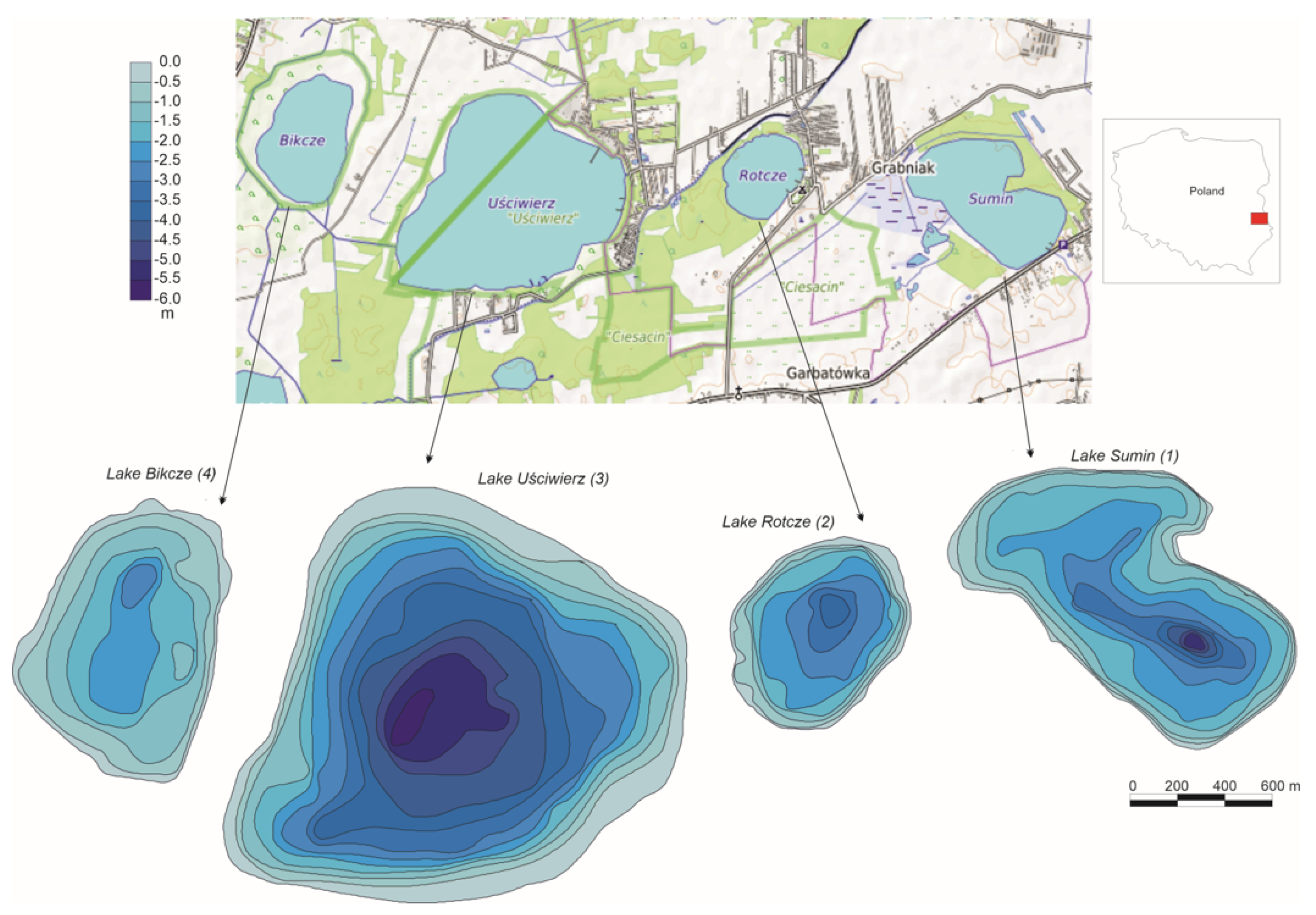
Figure 1. Location and morphometry of the study lakes (1–4) lakes order in the chain system.
Water 16 00384 g001
Figure 2. Water level (cm) fluctuation of: (a) streams and (b) lakes. 1—inflow into Bikcze Lake; 2—outflow from Bikcze Lake; 3—inflow into Rotcze Lake; 4—western inflow into Sumin Lake; 5—Southern inflow into Sumin Lake; 6—outflow from Sumin Lake; 7—Sumin Lake; 8—Rotcze Lake; 9—Bikcze Lake; 10—Uściwierz Lake.
Water 16 00384 g002
Figure 3. Renewal time of the study lakes. 1. Lake Sumin; 2. Lake Bikcze; 3. Lake Uściwierz; 4. Lake Rotcze.
Water 16 00384 g003
Figure 4. Differences in the structure of the water renewal rate between the neighboring lakes in the chain system. S/R—compared Lakes Sumin and Rotcze; R/U—compared Lakes Rotcze and Uściwierz; U/B—compared Lakes Uściwierz and Bikcze; 1—monthly period; 2—10-day period; 3—5-day period.
Water 16 00384 g004
Table 1. Morphometric characteristics of the study lakes.
Lake SuminLake RotczeLake UściwierzLake Bikcze
Area (m2)959,796437,4762,385,872710,900
Volume (m3)1,612,475766,7435,960,849804,612
Maximum depth (m)5.43.95.922.7
Mean depth (m)1.681.752.491.13
Length (m)146384721811206
Width (m)10036751875860
Shoreline (m)4355250561063347
Table 2. Hydrometeorological conditions (monthly sums of precipitation (mm) and average monthly discharge (L/s)).
Aug 17Sep 17Oct 17Nov 17Dec 17Jan 18Feb 18Mar 18Apr 18May 18Jun 18Jul 18Aug 18
Monthly sums of precipitation
79.854.595.861.231.517.016.95.55716.348.16.7121.6
Average discharge
1.6.208.7518.9529.7221.7128.2154.9926.0124.094.127.158.448.79
2.2.515.0217.5031.4932.9518.66117.70105.0780.3322.5515.9154.5074.42
3.1.971.362.788.7013.329.1810.8512.5310.439.481.370.976.01
4.1.322.4515.5423.3827.7529.8240.7436.0641.9022.854.161.376.31
5.3.001.372.856.7316.8519.1138.6333.5933.7131.0311.067.063.24
6.2.512.204.366.6813.4275.26122.04110.8068.8344.073.654.153.83
Notes: 1—inflow into Bikcze Lake; 2—outflow from Bikcze Lake; 3—inflow into Rotcze Lake; 4—western inflow into Sumin Lake; 5—southern inflow into Sumin Lake; 6—outflow from Sumin Lake.
Table 3. Variability of lakes’ areas (m2) and volume (m3) during the study period.
Lake SuminLake RotczeLake UściwierzLake Bikcze
Min. area934,907417,1152,243,524665,933
Max. area985,657437,4762,633,107759,038
Min. volume1,483,141657,0055,381,452632,739
Max. volume1,856,186879,4202,633,107988,482
Table 4. Percentage of compartments that meet the condition of a very small difference (SDI < 0.1) due to the water renewal rate.
U/BR/US/R
Month42.948.657.1
10-day period56.460.079.5
5-day period73.482.388.6
Disclaimer/Publisher’s Note: The statements, opinions and data contained in all publications are solely those of the individual author(s) and contributor(s) and not of MDPI and/or the editor(s). MDPI and/or the editor(s) disclaim responsibility for any injury to people or property resulting from any ideas, methods, instructions or products referred to in the content.