Article

Analysis of the Relationship Between Groundwater Dynamics and Changes in Water and Salt in Soil Under Subsurface Pipe Salt Drainage Technology

1
Institute of Agricultural Resources and Environment, Ningxia Academy of Agricultural and Forestry Sciences, Yinchuan 750002, China
2
National Agricultural Environment Observation and Experiment Station in Yinchuan, Yinchuan 750002, China
3
Institute of Crop Research, Ningxia Academy of Agricultural and Forestry Sciences, Yinchuan 750002, China
*
Authors to whom correspondence should be addressed.
These authors contributed equally to this work.
Water 2024, 16(24), 3597; https://doi.org/10.3390/w16243597
Submission received: 5 November 2024 / Revised: 27 November 2024 / Accepted: 9 December 2024 / Published: 13 December 2024

Abstract

:
Groundwater conditions are crucial for understanding the evolution of soil salinization. The installation of subsurface pipes significantly alters both the distribution of water and salt in the soil and the groundwater depth; these dynamics and their interrelationships warrant further investigation. To clarify the relationship between groundwater dynamics and changes in water and salt in soil under subsurface pipe salt drainage conditions in the Yinchuan region of Ningxia, groundwater observation wells and soil sample monitoring points were established in Pingluo County. A combined approach of in situ monitoring and laboratory testing was employed to analyze changes in groundwater depth and salinity and their effects on water and salt in soil. The findings revealed that changes in groundwater depth and salinity exhibited clear seasonal patterns. The groundwater depth was deepest at 1.97 m in October and shallowest at 1.62 m in July. The salinity was highest at 22.28 g/L in April and lowest at 18.24 g/L in August. In summer, the groundwater was shallower and had lower salinity, while in other seasons, it was deeper with higher salinity. Soil salinity was lowest in July at 4.58 g/kg and highest in April at over 5.5 g/kg. It decreased with increasing groundwater depth, demonstrating a linear relationship. Additionally, soil salinity and groundwater salinity exhibited synchronous fluctuations, exhibiting an exponential relationship. Based on these observations, a model was developed to describe the relationship among groundwater salinity, groundwater depth, and soil salinity under subsurface pipe salt drainage conditions in the Yinbei region of Ningxia. This model was validated against measured data, yielding a correlation coefficient R2 of 0.7238. These findings provide a reference for analyzing the relationship between soil salinity and groundwater in similar regions.

1. Introduction

Soil salinization is a significant factor contributing to soil degradation, reduced crop yields, and ecological deterioration [1,2], which severely hinders sustainable agricultural development. Saline soils in China are primarily distributed in coastal, north, northeast, and northwest regions of China, covering an area of over 3.5 × 10⁸ hm2 [3,4]. As an important reserve of cultivated land, the rational use of saline soils is crucial for ensuring food security and maintaining farmland red line.
Ningxia is located in the arid inland region of northwest China, where the northern Yellow River irrigation area is influenced by climatic and human factors. It features a high evaporation-to-precipitation ratio, low topography, high groundwater levels, and significant upward movement of salts [5], resulting in severe soil salinization. The area of salinized farmland is approximately 1.4 × 10⁶ hm2 and accounts for 32.5% of total area [6]. Salt sources, media, and driving forces are the main factors contributing to soil salinization, where climate, groundwater, and surface cover are key driving forces of water and salt migration in soil [7]. Groundwater serves as both a source and a carrier of salts. When groundwater is shallow, soil moisture and groundwater exchange frequently. Under evaporation, high-salinity groundwater rises through capillaries, and water evaporation causes salts to accumulate on the surface, leading to soil salinization [8]. When differences in groundwater salinity are minimal, a shallower groundwater depth can exacerbate soil salt accumulation. Conversely, when groundwater depth remains constant, higher groundwater salinity will lead to greater soil salt accumulation. Phreatic evaporation is a fundamental driving factor for soil salt migration in the arid inland regions of northwest China. In particular, the scarcity of rainfall and the high evaporation rates in these arid regions lead to pronounced vertical movement of groundwater. Continuous evaporation of moisture at the wet–dry interface in the soil leads to the accumulation of salts [9]. In the Bohai Rim Plain region of eastern China, significant changes in soil salinity occur when the groundwater depth is less than 3 m; however, changes are minimal at depths greater than 3 m. Soil salinity exhibits minimal changes when groundwater salinity is below 2 g/L. An increasing trend is observed when groundwater salinity ranges between 2 and 5 g/L, and a marked increase occurs when groundwater salinity exceeds 5 g/L. Thus, groundwater conditions are critical to the evolution of soil salinization.
Current research on groundwater and soil salinity is predominantly conducted through site-point monitoring and model simulations. By integrating laboratory simulations with outdoor experiments, more reliable conclusions can be drawn. The data fitting from outdoor monitoring in arid regions indicates that the salinity of saline soils exhibits exponential and linear relationships with groundwater depth and salinity, respectively. In addition, the highest correlation was observed between surface soil salinity and groundwater depth [10]. Researchers in recent years have proposed techniques such as straw burying for salt isolation [11,12,13] and subsurface pipe (or ditch) salt drainage [14,15]. Subsurface pipes that serve as underground drainage facilities effectively reduce soil salinity and control groundwater levels to prevent the return of salts. Consequently, they have become essential infrastructure in high-standard farmland construction projects and have been extensively implemented [16,17]. Due to the flat and low-lying topography of the Yellow River irrigation area in China, the high groundwater level contributes significantly to soil salinization. Some studies have demonstrated that groundwater is deeper in April and shallower in November, with higher salinity at smaller groundwater depths and lower salinity at greater groundwater depths [18]. Soil salinity is closely related to groundwater conditions. Current studies on groundwater under subsurface pipe salt drainage conditions primarily focuses on simulation aspects [19]. Discrepancies arising from climatic differences between northern and southern regions of China can be addressed by employing monitoring and numerical analysis of soil and groundwater in the field. The installation of subsurface pipes results in new distribution patterns of water and salt in the soil, as well as changes in groundwater depth; thus, their changing rules and interrelationships require further study. However, there is limited research on the dynamics of soil salinity and groundwater in the Yinbei irrigation area of Ningxia under these conditions. The relationships between groundwater depth, groundwater salinity, and soil salinity in this region require further investigation.
To this end, a combined approach of in situ monitoring and laboratory testing was employed to analyze changes in groundwater depth and salinity and their effects on water and salt in the soil. Monitoring points were established in the experimental area at Qianjin Farm in Pingluo County, Ningxia, where buried subsurface pipes were installed. By monitoring variations in groundwater dynamics and changes in water and salt in the soil, we clarified the interactions among water and salt in soil, groundwater depth, and groundwater salinity under subsurface pipe salt drainage conditions. Additionally, we developed a relational model linking soil salinity, groundwater depth, and groundwater salinity, which provides a reference for analyzing the relationship between soil salinity and groundwater in this region.

2. Materials and Methods

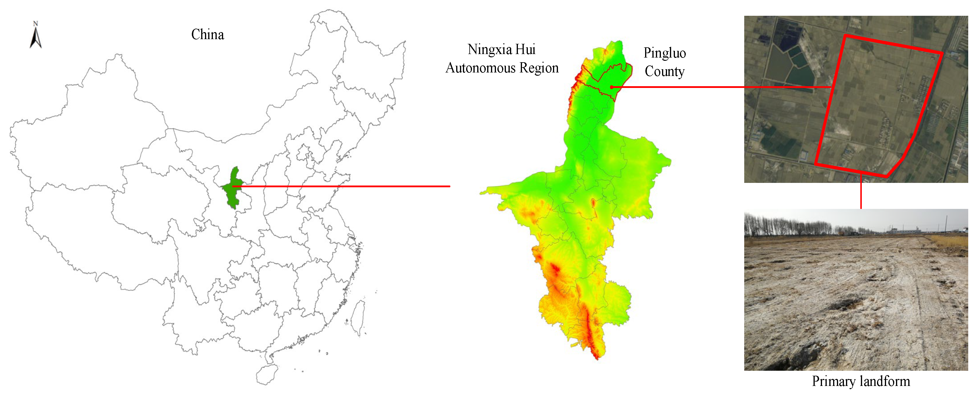
2.1. Overview of Experimental Area

The experimental area is located at Qianjin Farm (106°31′ E, 38°51′ N) in Pingluo County, Shizuishan City, Ningxia Hui Autonomous Region, China, and belongs to the Yellow River irrigation area (see Figure 1). It is characterized by flat, low-lying terrain, high groundwater levels, and severe soil salinization. This region has an arid continental climate and is part of the arid to semi-desert salinization area of the upper and middle reaches of the Yellow River. Rainfall is scarce and unevenly distributed throughout the year, with the majority occurring from July to September. The average annual precipitation and evaporation are 185 mm and 1841 mm, respectively. The experimental area is characterized by flat, low-lying terrain, which facilitates the accumulation of water and salt that results in high groundwater levels and high salinity in the region. Meanwhile, prolonged reliance on flood irrigation has led to deep leakage and higher groundwater levels. Before the installation of subsurface drainage pipes, groundwater levels in the experimental area ranged from 1.2 to 1.5 m, and the groundwater salinity exceeded 15 g/L. These conditions led to severe soil salinization within the experimental area. In addition, the experimental area has an arid continental climate, where intense evaporation during rare precipitation leads to the surface accumulation of soil salts and noticeable salt efflorescence in spring.
The clay particles (<0.002 mm), silt particles (0.002–0.02 mm), and sand particles (0.02–2.0 mm) of the soil in experimental area account for 13.5%, 26.9%, and 59.6%, respectively. This particle distribution classifies the soil texture as sandy loam. Additionally, the soil exhibits salinity, bulk density, and pH value ranging from 6.1 to 10.11 g/kg, 1.36 to 1.68 g/cm³, and 8.55 to 10.10, respectively, as detailed in Table 1.

2.2. Experimental Design and Implementation Process

In 2022, a high-standard farmland construction project was implemented in the experimental area, with uniform installation of subsurface pipe salt drainage facilities. The subsurface pipes were buried at depths ranging from 1.3 to 1.5 m, with a spacing of 60 m between subsurface pipes and a slope of 3‰. The crops cultivated in this area primarily include corn and sorghum. In the fall of 2022, an 8.0 hm2 section of the experimental area was selected as the research site, where 12 groundwater observation wells were installed (see Figure 2). The distance between the monitoring points and the subsurface pipes was 30 m. Monitoring of groundwater depth and salinity began in April 2023. Soil sampling points were established around the observation wells, where soil cores were collected at depths of 0–20 cm, 20–40 cm, and 40–60 cm using a soil drill for determining the moisture content and salinity of the soil. The observation wells were constructed using PVC pipes with a diameter of 110 mm and a length of 4.0 m. The lower ends of the pipes were randomly perforated with holes measuring 10 mm in diameter, and these holes were wrapped with filter screen to prevent the intrusion of soil particles. Water samples were collected on a monthly basis, and soil samples from depths ranging from 0 to 60 cm were simultaneously collected around the observation wells, with each soil sample collected in triplicate.

2.3. Sample Collection and Parameter Determination

Collected soil samples were cleaned of debris, air-dried, and then ground and sieved [6]. Water salinity was measured using a conductivity meter (Mettler Toledo S230, METTLER TOLEDO, Switzerland. Bought it in Shanghai, China), and groundwater depth was determined using a water level meter [10]. Soil moisture content was measured using the drying method [20]. A soil-to-water ratio of 1:5 was shaken thoroughly to obtain the supernatant for pH measurement with a pH meter, while soil conductivity was measured using a conductivity meter, which was then converted into soil salinity [20].

3. Results

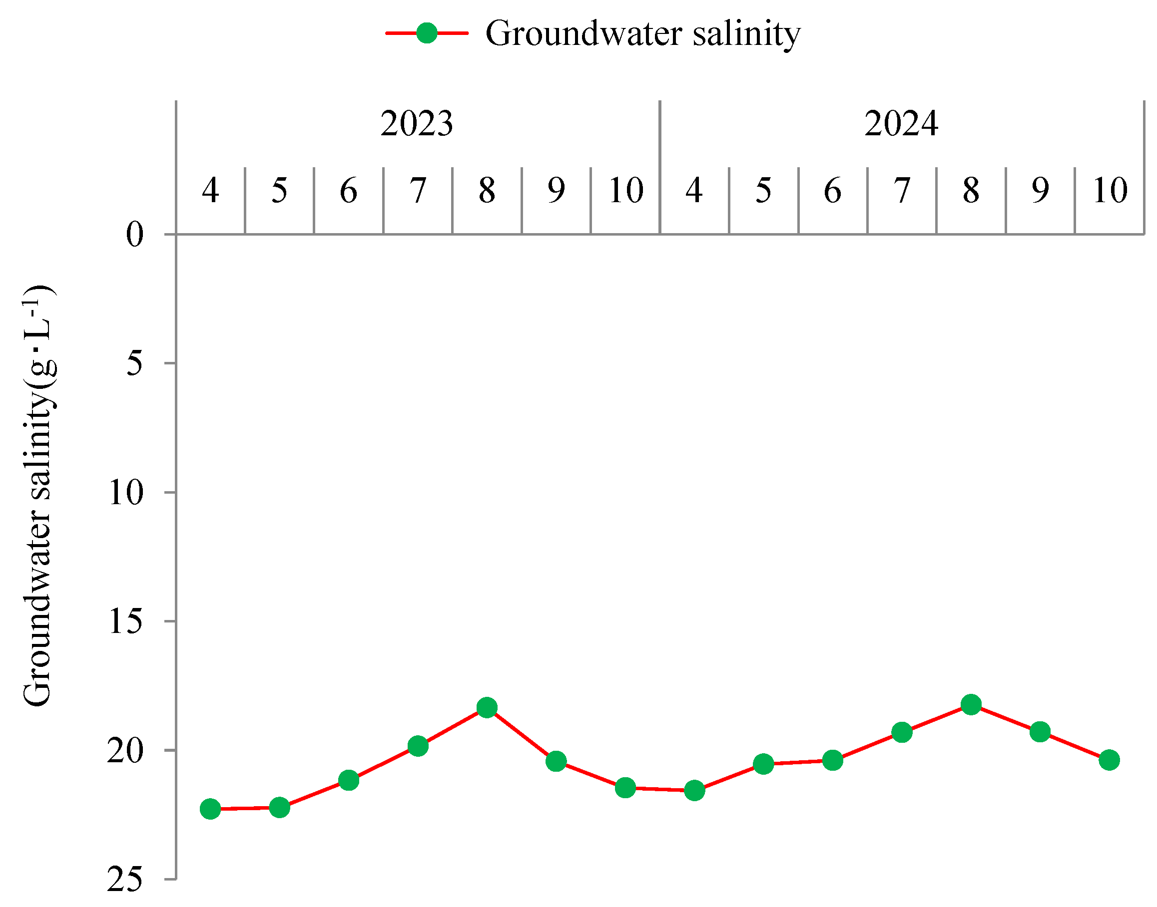
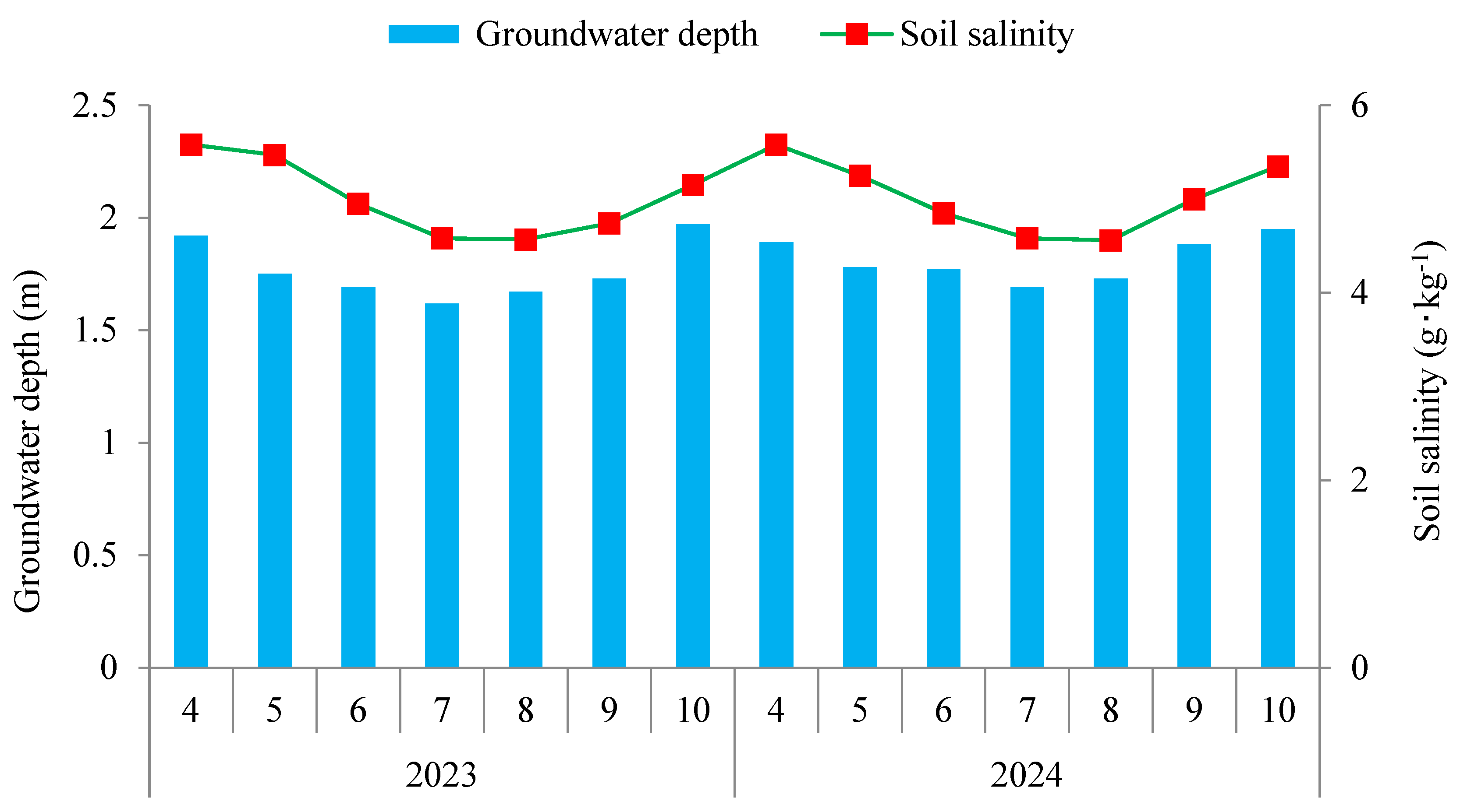
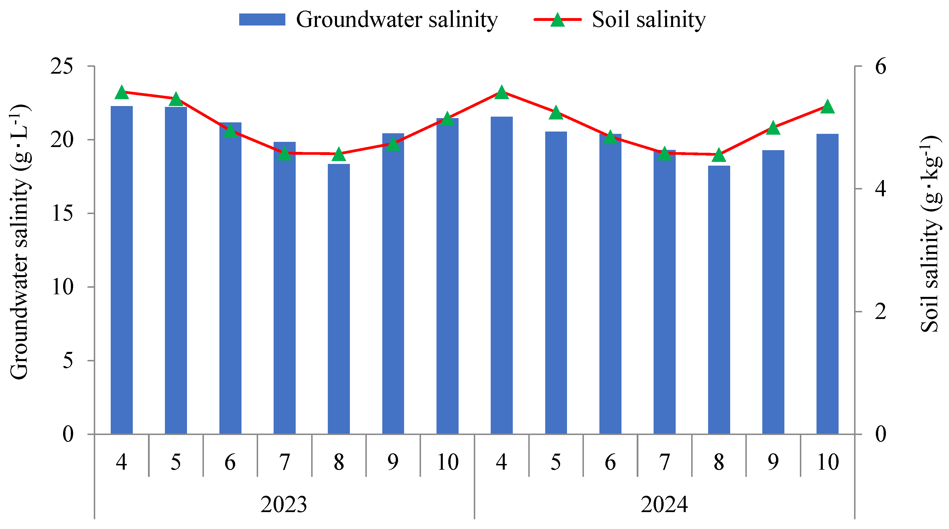
3.1. Changes in Groundwater Depth and Groundwater Salinity

This research focused on the changes in soil water, salt, and groundwater during the corn growing season from April to October in northwest China. In the experimental area, groundwater was shallower in summer and deeper in other seasons. In October 2023, groundwater depth reached its deepest at 1.97 m, while in July 2023, it was at its shallowest at 1.62 m, indicating seasonal variations throughout the year (see Figure 3). During the summer, irrigation and rainfall contributed to relatively shallow groundwater levels. Following autumn, except for winter irrigation, reduced precipitation and intense surface evaporation led to a gradual deepening of the groundwater level in the experimental area. In April 2023, groundwater salinity peaked at 22.28 g/L, while in August 2024, it was at its minimum of 18.24 g/L (see Figure 4). Groundwater salinity in the experimental area also showed seasonal variations, and it was lower in summer and higher in other seasons. In summer, artificial irrigation and rainfall contributed to the replenishment and dilution of groundwater, resulting in lower depth and salinity.

3.2. Relationship Between Soil Moisture Content and Groundwater

Groundwater is closely related to soil moisture content. The shallow groundwater leads to frequent moisture exchange between soil and groundwater, affecting soil water movement. The variations in soil moisture content, groundwater depth, and groundwater salinity during the crop growing seasons from April to October over two years were utilized to analyze their interrelationships. In July 2023, soil moisture content was highest at 21.5%, while shallowest groundwater depth recorded was 1.62 m. The relationship between soil moisture content and groundwater depth in the 0–60 cm soil depth showed that when groundwater was shallow, soil moisture content was high, and vice versa (see Figure 5). In July 2024, groundwater salinity reached its maximum of 21.4 g/L, and there was no significant correlation observed between soil moisture content and groundwater salinity within the 0–60 cm soil depth (see Figure 6).

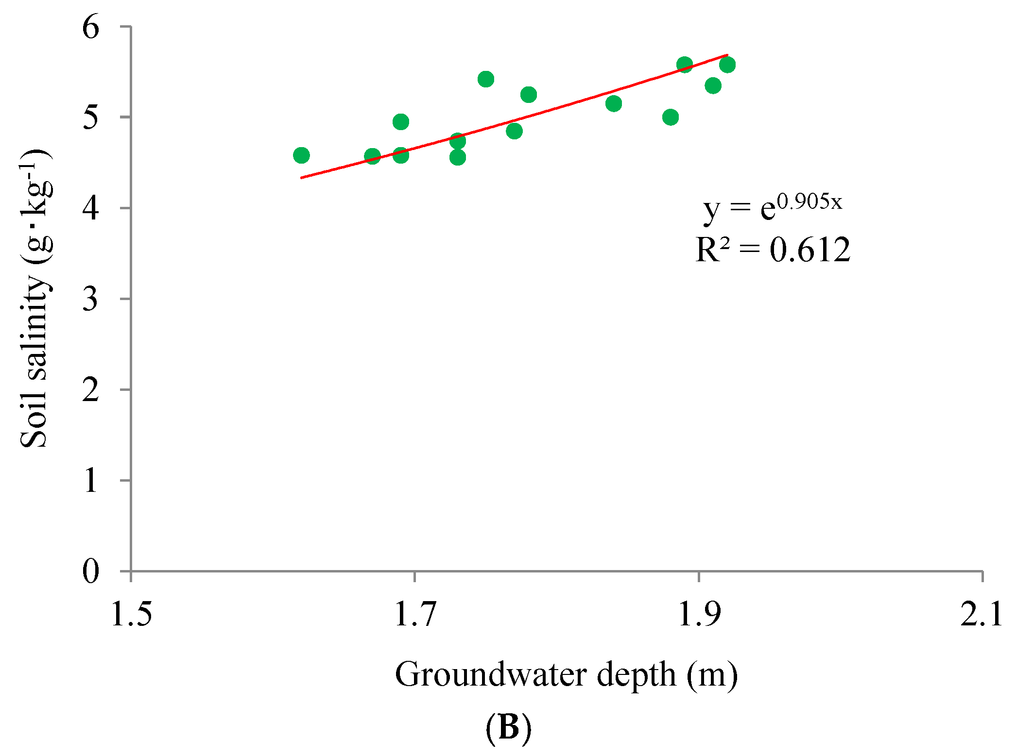
3.3. Relationship Between Soil Salinity and Groundwater Depth

In arid low-lying saline soil regions, groundwater is the primary factor affecting soil salinity. Shallow groundwater, scarce rainfall, and intense evaporation in arid regions cause groundwater to rise through capillaries. As water evaporates, salts are left and accumulate on the surface, leading to severe surface salinization. The variations in soil salinity and groundwater depth during the crop growing seasons from April to October over two years were employed to clarify their interrelationships. In July 2023, the groundwater was shallowest at 1.62 m, and the soil salinity was lowest at 4.58 g/kg. In both 2023 and 2024, soil salinity peaked in April, exceeding 5.5 g/kg (see Figure 7). During the summer, artificial irrigation or rainfall in summer leached soil salts, while leaching water helped replenish groundwater, causing its depth to decrease. In the absence of irrigation, surface evaporation and crop transpiration deepened the groundwater, while evaporation caused salts to migrate upwards with soil water, resulting in salt accumulation. Soil desalinization occurred as groundwater depth decreased; conversely, soil salinization occurred as groundwater depth increased. Therefore, maintaining groundwater depth at an appropriate level can enhance salt leaching and avoid salt return. There were functional relationships between soil salinity and groundwater depth, where the correlation coefficients R2 for linear and exponential function fittings were 0.663 and 0.612, respectively (Figure 8). A higher correlation coefficient R2 for the linear function suggested a better linear relationship between soil salinity and groundwater depth compared to the exponential relationship.

3.4. Relationship Between Soil Salinity and Groundwater Salinity

High-salinity groundwater is one of the primary sources of soil salts. This is particularly true in arid low-lying areas, where variations in groundwater depth are minimal, and the high-salinity groundwater is the key factor affecting soil salinity. The variations in soil salinity and groundwater salinity during the crop growing seasons from April to October over two years were used to elucidate their interrelationships. Groundwater salinity in the experimental area was closely related to soil salinity, which was primarily characterized by synchronous fluctuations: as groundwater salinity decreased, soil salinity decreased, and vice versa (Figure 9). There were functional relationships between soil salinity and groundwater salinity, where the correlation coefficients R2 for linear and exponential function fittings were 0.6257 and 0.6846, respectively (Figure 10). A higher correlation coefficient R2 for the exponential function suggested a better exponential relationship between soil salinity and groundwater salinity compared to the linear relationship.

3.5. Relationship Among Soil Salinity, Groundwater Depth, and Groundwater Salinity

In arid low-lying saline soil regions, groundwater depth and groundwater salinity significantly affect soil salinity. The above analyses demonstrated that soil salinity exhibits a linear relationship with groundwater depth and an exponential relationship with groundwater salinity, which can be expressed as follows:
S = a 1 × n
S = a 2 × e b m
where S is the soil salinity in g/kg; a1, a2, and b are constants; n is the groundwater salinity in g/L; and m is groundwater depth in m.
Multiplying Equations (1) and (2) yields the exponential expression that describes the relationship between soil salinity, groundwater salinity, and groundwater depth.
S 2 = a × n × e b m
where a is the constant.
Dividing both sides of Equation (3) by groundwater salinity n yields the relationship between the ratio (N) of the square of soil salinity to groundwater salinity and the groundwater depth (m):
N = S 2 / n = a × e b m
The relationship between the ratio (N) of the square of the measured soil salinity to groundwater salinity and the groundwater depth (m) is established, as depicted in Figure 11.
Figure 10 indicates an exponential relationship between the N and groundwater depth, with a correlation coefficient R2 of 0.7238. This finding suggests that the exponential model effectively describes the relationship between the ratio of the square of soil salinity to groundwater salinity and the groundwater depth. In the experimental area, a significant relationship was observed between soil salinity and both groundwater depth and salinity. Based on the collected data on groundwater depth and salinity, the established relationship can be utilized to analyze soil salinity.

4. Discussion

Climate, topography, groundwater, surface vegetation, and irrigation facilities collectively form an interconnected and interdependent ecosystem that influences regional water and salt dynamics in soil [21]. The experimental area experiences an arid continental climate. It has an average annual precipitation of 185 mm and an average annual evaporation of 1841 mm, respectively. During the summer, artificial irrigation and rainfall contributed to the replenishment and dilution of groundwater, resulting in shallower depth and lower salinity. Specifically, artificial irrigation or rainfall leached soil salts, while leaching water helped replenish groundwater, causing its depth to decrease. Soil desalinization occurred as groundwater depth decreased; conversely, soil salinization occurred as groundwater depth increased.
A previous study demonstrated that groundwater is deeper in April and shallower in November in paddy fields, with higher salinity observed at lower groundwater depths and lower salinity at higher depths [18]. In our research, groundwater was deepest in October and shallowest in July. Groundwater salinity was highest in April and lowest in August. This variation can be attributed to different cropping patterns; in Ningxia, rice is typically planted in late April or early May, and irrigation practices differ. No irrigation occurs until late April, and intense evaporation in the spring leads to deepening groundwater. Rice is harvested in October, followed by winter irrigation in November, resulting in shallow groundwater level. The diversity in crop management results in differing changes in groundwater depth.
The experimental area, characterized by low topography, high groundwater levels, and sparse surface vegetation, is located in the arid inland region of northwest China. In the absence of irrigation, strong surface evaporation occurs, and moisture in the soil profile migrates to the upper soil layer in the form of capillary water under the combined action of temperature and matric potential gradients [22]. Salts migrate upward with moisture acting as both the medium and carrier, with capillary water remaining in a liquid state during this process. Once soil moisture content reaches the capillary rupture point, water vaporizes, which causes salts to crystallize and accumulate on the surface, thereby leading to surface accumulation of soil salts [23]. Groundwater depth and salinity directly affect soil salinization. Regions with a higher groundwater depth exhibit effective leaching and desalination, thus reducing the risk of salt return. In contrast, regions with shallow groundwater experience inadequate leaching and a higher likelihood of salt return. Shallow, high-salinity groundwater regions are more prone to secondary soil salinization [24]. Before installing the subsurface pipes, groundwater depth in the experimental area ranged from 1.2 to 1.5 m, resulting in severe secondary soil salinization. After installation, groundwater depth significantly decreased, with a depth greater than 1.6 m (Figure 3). In the experimental area, soil salinity increased as groundwater depth decreased, exhibiting a linear relationship. Additionally, soil salinity increased with rising groundwater salinity, demonstrating an exponential relationship. A decrease in groundwater depth shortened the “migration path” for soil salinity [25], while high-salinity groundwater served as a “salt source” [26]. The low rainfall and high evaporation under arid conditions led to an increasing trend in soil salinity in this region. Therefore, employing subsurface pipe salt drainage technique to lower and control groundwater levels in low-lying saline soil regions can effectively manage and sustain the utilization of saline soils.
In the Bohai Rim Plain region of eastern China, soil salinity undergoes significant changes when the groundwater depth is less than 3 m, whereas changes are minimal at depths greater than 3 m. Soil salinity exhibits minimal changes when groundwater salinity is below 2 g/L, shows an increasing trend when groundwater salinity is 2–5 g/L, and experiences a marked increase when groundwater salinity exceeds 5 g/L [27]. The critical groundwater depth in the Bohai Rim Plain region of eastern China is 3 m, while it is 1.7 m in the inland region of northwest China [28]. This difference is attributed to climatic variations, as the eastern coastal areas experience a subtropical monsoon climate, whereas northwest China exhibits an arid continental climate, resulting in significant differences in evaporation-to-precipitation ratios. Well-developed irrigation and drainage facilities are essential for maintaining regional soil water–salt balance. Efficient drainage systems can facilitate the removal of leaching water from farmland, thereby reducing soil salinity and effectively controlling groundwater levels to prevent the salts returning. Prior to improvement, the drainage ditches in the experimental area were severely collapsed, resulting in poor drainage and a groundwater depth of 1.2–1.5 m. The preliminary plan for the experimental area involved establishing a comprehensive irrigation and drainage system, wherein subsurface pipes were installed perpendicular to the ditches for effective salt drainage. Additionally, the ditches were deepened to 2.5 m, which significantly promoted farmland drainage while controlling groundwater depth. Overall, both groundwater depth and salinity influence the spatial and temporal distribution of soil salinity in the experimental area.
The implementation of high-standard farmland construction projects has facilitated the widespread adoption of high-efficiency water-saving irrigation technologies. The results from this study corroborate that while flood irrigation can leach soil salt, it also raises groundwater levels and increase the risk of soil secondary salinization. Particularly in the arid area of northwest China, challenges such as water shortage, drought climate, and large saline-alkali soils are prevalent. Therefore, efficient and rational utilization of water resources is crucial. By employing water-saving irrigation measures, a suitable water and salt environment can be created for crop root systems in agricultural areas, while simultaneously facilitating the migration of soil salts in non-crop areas to achieve effective salt management. In northern China, areas without greenhouse facilities do not cultivate crops during winter; hence, flooding irrigation during this period can effectively wash away soil salts and prevent salt return in spring. This approach not only enhances water resource utilization but also contributes to the efficient improvement and utilization of saline-alkali land, thus securing food security.
This study examined the changes in soil water, salt, and groundwater during the corn growing season from April to October in northwest China. It is noteworthy that changes in soil water and salt during the frozen period were not considered due to the absence of crop growth and artificial irrigation. Therefore, investigating the changes in soil and groundwater during both frozen and non-frozen periods presents an innovative research direction for this area. Future efforts will focus on monitoring these changes more closely.

5. Conclusions

A combined approach of in situ monitoring and laboratory testing was employed to analyze the relationship between groundwater dynamics and changes in water and salt in soil under subsurface pipe salt drainage technology within the Yellow River irrigation area of Ningxia, China. The conclusions are as follows.
(1)
Both the groundwater depth and salinity in the experimental area exhibited seasonal variations. Specifically, the groundwater exhibited lower salinity and depth in summer, while it had higher salinity and depth in other seasons. The maximum groundwater depth recorded was 1.97 m in October, while the minimum was 1.62 m in July. Groundwater salinity was highest at 22.28 g/L in April and lowest at 18.24 g/L in August.
(2)
Soil salinity was lowest at 4.58 g/kg in July and highest at over 5.5 g/kg in April in the experimental area. Soil salinity was positively correlated with groundwater salinity (an exponential relationship) and negatively correlated with groundwater depth (a linear relationship). On the basis of these findings, a relationship between soil salinity, groundwater salinity, and groundwater depth in the low-lying saline soil region of Yellow River irrigation area of Ningxia, was established. This model was validated with actual measurements, resulting in a correlation coefficient R2 of 0.7238.

Author Contributions

Investigation, X.W. and J.C.; Data curation, J.S. and L.F.; Writing—original draft, X.W. and J.S.; Writing—review and editing, X.W.; Visualization, L.F. and J.C. All authors have read and agreed to the published version of the manuscript.

Funding

This research was funded by Ningxia Hui Autonomous Region key research and development project (2023BCF01050); National Natural Science Foundation (42367043); Ningxia Natural Science Foundation (2024AAC03373); Agricultural Science and Technology Independent Innovation of Ningxia Hui Autonomous Region (NGSB-2021-11-03); and Observation and Monitoring of Basic Long-Term Scientific and Technological Work in Agriculture (NAES091AE18).

Data Availability Statement

Data are contained within the article.

Conflicts of Interest

The authors declare no conflicts of interest.

References

  1. Tarolli, P.; Luo, J.; Park, E.; Barcaccia, G.; Masin, R. Soil salinization in agriculture: Mitigation and adaptation strategies combining nature-based solutions and bioengineering. iScience 2024, 27, 108830. [Google Scholar] [CrossRef] [PubMed]
  2. Cuevas, J.; Daliakopoulos, I.; Moral, F.; Hueso, J.; Tsanis, I. A review of soil-improving cropping systems for soil salinization. Agronomy 2019, 9, 295. [Google Scholar] [CrossRef]
  3. Yang, J.; Yao, R.; Wang, X.; Xie, W.; Zhang, X.; Zhu, W.; Zhang, L.; Sun, R. Research on Salt-affected Soils in China: History, Status Quo and Prospect. Acta Pedol. Sin. 2022, 59, 10–27. (In Chinese) [Google Scholar]
  4. James, O. History of the roles of gypsum in soil reclamation and establishment of SAR/EC water quality guidelines. In Proceedings of the First IUSS Conference on Sodic Soil Reclamation, Changchun, China, 30 July–2 August 2021. [Google Scholar]
  5. Liu, T.; Wang, B.; Xiao, H.; Wang, R.; Yang, B.; Cao, Q.; Cao, Y. Differentially improved soil microenvironment and seedling growth of Amorpha fruticosa by plastic, sand and straw mulching in a saline wasteland in northwest China. Ecol. Eng. 2018, 122, 126–134. [Google Scholar] [CrossRef]
  6. Wang, X.; Shen, J.; Fan, L.; Zhang, Y. Research on Salt Drainage Efficiency and Anti-Siltation Effect of Subsurface Drainage Pipes with Different Filter Materials. Water 2024, 16, 1432. [Google Scholar] [CrossRef]
  7. Zhang, X.; Shu, C.; Wu, Y.; Ye, P.; Du, D. Advances of coupled water-heat-salt theory and test techniques for soils in cold and arid regions: A review. Geoderma 2023, 432, 116378. [Google Scholar] [CrossRef]
  8. Hassani, A.; Azapagic, A.; Shokri, N. Global predictions of primary soil salinization under changing climate in the 21st century. Nat. Commun. 2021, 12, 6663. [Google Scholar] [CrossRef]
  9. Fan, L.; Shen, J.; Wang, X.; Zhang, Y. Effects of Ditch Water and Yellow River Irrigation on Saline-Alkali Characteristics of Soil and Paddy. Water 2024, 16, 2598. [Google Scholar] [CrossRef]
  10. Li, C.; Gao, X.; Li, S.; Bundschuh, J. A review of the distribution, sources, genesis, and environmental concerns of salinity in groundwater. Environ. Sci. Pollut. Res. 2020, 27, 41157–41174. [Google Scholar] [CrossRef]
  11. Chen, M.; Wang, G.; Jing, Y.; Zhou, J.; Song, J.; Chang, F.; Yu, R.; Wang, J.; Wang, W.; Sun, X.; et al. Straw interlayer improves sunflower root growth: Evidence from moisture and salt migration and the microbial community in saline-alkali soil. J. Integr. Agric. 2024, 11, 3870–3881. [Google Scholar] [CrossRef]
  12. Chang, F.; Zhang, H.; Song, J.; Yu, R.; Zhang, X.; Li, H.; Wang, J.; Kan, Z.; Li, Y. Once-middle amount of straw interlayer enhances saline soil quality and sunflower yield in semi-arid regions of China: Evidence from a four-year experiment. J. Environ. Manag. 2023, 344, 118530. [Google Scholar] [CrossRef] [PubMed]
  13. Lu, P.; Bainard, L.; Liu, J. Bio-fertilizer and rotten straw amendments alter the rhizosphere bacterial community and increase oat productivity in a saline–alkaline environment. Sci. Rep. 2020, 10, 19896. [Google Scholar] [CrossRef] [PubMed]
  14. Ritzema, H.; Abdel-Dayem, S.; El-Atfy, H.; Nasralla, M.; Shaheen, H. Challenges in modernizing the subsurface drainage systems in Egypt. Agric. Water Manag. 2023, 288, 108484. [Google Scholar] [CrossRef]
  15. Soe, Y.; Shinogi, Y.; Taniguchi, T. Changes in Certain Paddy Soil Properties under Perforated Sheet Pipe as Subsurface Shallow Drainage. Jpn. Agric. Res. Q. JARQ 2022, 56, 59–66. [Google Scholar] [CrossRef]
  16. Askri, B.; Khodmi, S.; Bouhlila, R. Impact of subsurface drainage system on waterlogged and saline soils in a Saharan palm grove. Catena 2022, 212, 106070. [Google Scholar] [CrossRef]
  17. Ghane, E.; Dialamel, B.; Abdalaal, Y.; Ghane, M. Knitted-sock geotextile envelopes increase drain inflow in subsurface drainage systems. Agric. Water Manag. 2022, 274, 107939. [Google Scholar] [CrossRef]
  18. Yang, J.; Sun, Z.; Wang, X. Analysis of Annual Spatial and Temporal Variation Characteristics of Groundwater Depth, Salinity and Salt ions of Crack Alkaline Land. Water Sav. Irrig. 2016, 3, 45–48. (In Chinese) [Google Scholar]
  19. Liu, Y.; Ao, C.; Zeng, W.; Srivastava, A.; Gaiser, T.; Wu, J.; Huang, J. Simulating water and salt transport in subsurface pipe drainage systems with HYDRUS-2D. J. Hydrol. 2021, 592, 125823. [Google Scholar] [CrossRef]
  20. Wang, X.; Zhang, Y.; Fan, L.; Shen, J. Salt Drainage Efficiency and Anti-Clogging Effects of Subsurface Pipes Wrapped with Geotextiles. Water 2024, 16, 1392. [Google Scholar] [CrossRef]
  21. Negacz, K.; Malek, Z.; Vos, A.; Vellinga, P. Saline soils worldwide: Identifying the most promising areas for saline agriculture. J. Arid. Environ. 2022, 203, 104775. [Google Scholar] [CrossRef]
  22. Abedi-Koupai, J.; Ansari, S.; Mostafazadeh-Fard, B.; Shayannejad, M.; Mosaddeghi, M. Experimental study and numerical simulation of soil water and salt transport under dry drainage conditions. Environ. Earth Sci. 2020, 79, 89. [Google Scholar] [CrossRef]
  23. Wang, Z.; Chen, R.; Li, W.; Zhang, J.; Zhang, J.; Song, L.; Wang, J.; Li, H.; Mou, H.; Li, Z.; et al. Mulched drip irrigation: A promising practice for sustainable agriculture in China’s arid region. Npj Sustain. Agric. 2024, 2, 17. [Google Scholar]
  24. Haj-Amor, Z.; Hashemi, H.; Bouri, S. Soil salinization and critical shallow groundwater depth under saline irrigation condition in a Saharan irrigated land. Arab. J. Geosci. 2017, 10, 301. [Google Scholar]
  25. Liu, P.; Zhang, G.; Cui, S.; Nie, Z.; Cui, H.; Wang, Q. Effects of Groundwater Level Control on Soil Salinity Change in Farmland around Wetlands in Arid Areas: A Case Study of the Lower Reaches of the Shiyang River Basin, China. Water 2023, 15, 1308. [Google Scholar] [CrossRef]
  26. Cui, H.; Bai, J.; Du, S.; Wang, J.; Keculah, G.; Wang, W.; Zhang, G.; Jia, J. Interactive effects of groundwater level and salinity on soil respiration in coastal wetlands of a Chinese delta. Environ. Pollut. 2021, 286, 117400. [Google Scholar]
  27. Zhou, Z.; Zhang, G.; Wang, J.; Yan, M. Spatial pattern of soil salinity and soil salinization in area around Bohai Sea. Trans. Chin. Soc. Agric. Eng. 2010, 26, 15–20+385. (In Chinese) [Google Scholar]
  28. Zhang, Y.; Hou, K.; Qian, H.; Gao, Y.; Fang, Y.; Xiao, S.; Tang, S.; Zhang, Q.; Qu, W.; Ren, W. Characterization of soil salinization and its driving factors in a typical irrigation area of Northwest China. Sci. Total Environ. 2022, 837, 155808. [Google Scholar]
Figure 1. Geographical position of experimental area (The colors red, yellow, and green represent the mountains, hills, and plains in Ningxia, respectively).
Water 16 03597 g001
Figure 2. Monitoring site of the experimental area (the dashed blue line indicates the subsurface pipe, and the black dots indicate the monitoring points, the red line square is the experimental area).
Water 16 03597 g002
Figure 3. Variations in groundwater depth.
Water 16 03597 g003
Figure 4. Variations in groundwater salinity.
Water 16 03597 g004
Figure 5. Relationship between soil moisture and groundwater depth.
Water 16 03597 g005
Figure 6. Relationship between soil moisture and groundwater salinity.
Water 16 03597 g006
Figure 7. Variations in soil salinity and groundwater depth.
Water 16 03597 g007
Figure 8. The fitted relationships between soil salinity and groundwater depth. (A) Linear relationship fitting. (B) Exponential relationship fitting.
Water 16 03597 g008aWater 16 03597 g008b
Figure 9. Variations in soil salinity and groundwater salinity.
Water 16 03597 g009
Figure 10. The fitted relationships between soil salinity and groundwater salinity. (A) Linear relationship fitting. (B) Exponential relationship fitting.
Water 16 03597 g010
Figure 11. Relationship between N and groundwater depth.
Water 16 03597 g011
Table 1. Saline-alkali properties of soil.
Soil Depth
(cm)
Soil TextureField Capacity
(%)
Bulk Density
(g·cm−3)
Porosity
(%)
Salinity
(g·kg−1)
pH Value
0–20sandy loam18.721.3648.6810.118.55
20–40sandy loam19.261.5143.027.799.24
40–60sandy loam19.871.6238.876.2110.10
60–80sandy loam20.251.6836.605.889.37
80–100sandy loam20.341.5940.006.109.29
Disclaimer/Publisher’s Note: The statements, opinions and data contained in all publications are solely those of the individual author(s) and contributor(s) and not of MDPI and/or the editor(s). MDPI and/or the editor(s) disclaim responsibility for any injury to people or property resulting from any ideas, methods, instructions or products referred to in the content.

