Article

Origin of Intercrystalline Brine Formation in the Balun Mahai Basin, Qaidam: Constraints from Geochemistry and H-O-Sr Isotopes

1
School of Geological Engineering, Qinghai University, Xining 810016, China
2
Key Laboratory of Cenozoic Resource & Environment in North Margin of the Tibetan Plateau, Xining 810016, China
3
Qinghai Institute of Salt Lake Research, Chinese Academy of Sciences, Xining 810008, China
4
SDI Xinjiang Lop Nur Potash Salt Co., Ltd., Hami 839000, China
5
Institute of Advanced Studies, China University of Geosciences, Wuhan 430074, China
6
The Fourth Geological Exploration Institute of Qinghai Province, Xining 810016, China
7
Qinghai Key Laboratory of Shale Gas Resources, Xining 810016, China
8
Qinghai Geological and Mineral Exploration and Development Bureau, Xining 810016, China
9
School of Earth Resources, China University of Geosciences, Wuhan 430074, China
*
Author to whom correspondence should be addressed.
Water 2024, 16(22), 3286; https://doi.org/10.3390/w16223286
Submission received: 30 September 2024 / Revised: 7 November 2024 / Accepted: 13 November 2024 / Published: 15 November 2024
(This article belongs to the Special Issue Saline Water and Brine Geochemistry)

Abstract

:
The Balun Mahai Basin (BLMH), located in the northern Qaidam Basin (QB), is endowed with substantial brine resources; however, the genetic mechanisms and potential of these brine resources remain inadequately understood. This study investigated the intercrystalline brine (inter-brine) in BLMH, performing a comprehensive geochemical analysis of elemental compositions and H-O-Sr isotopes. It evaluated the water source, solute origin, evolutionary process, and genetic model associated with this brine. Moreover, a mass balance equation based on the 87Sr/86Sr isotopic ratio was developed to quantitatively evaluate the contributions of Ca-Cl water and river water to the inter-brine in the study area. The results suggest that the hydrochemical type of inter-brine in the north part of BLMH is Cl-SO4-type and in the south part is Ca-Cl-type. The solutes in brine are mainly derived from the dissolution of minerals such as halite, sylvite, and gypsum. The hydrochemical process of brine is controlled by evaporation concentration, water–rock interaction, and ion exchange interaction. Hydrogen and oxygen isotopes suggest that the inter-brine originates from atmospheric precipitation or ice melt water and has experienced intense evaporation concentration and water–rock interaction. The strontium isotopes suggest that the inter-brine was affected by the recharge and mixing of Ca-Cl water and river water, which controlled the spatial distribution and formation of brine hydrochemical types. The analysis of ionic ratios suggest that the inter-brine is derived from salt dissolution and filtration, characterized by poor sealing and short sealing time in the salt-bearing formation. The differences in hydrochemical types and spatial distribution between the north and the south are fundamentally related to the replenishment and mixing of these two sources, which can be summarized as mixed origin model of “dissolution and filtration replenishment + deep replenishment” in BLMH.

1. Introduction

There is an increasing international competition for strategic mineral resources, such as boron, lithium, and potassium [1]. The scale of mineral resource mining and the degree of supply guarantee severely restrict the development of modern agriculture, advanced industry, and clean industry. Despite its own large mineral resources, China continues to exhibit a significant reliance on foreign strategic mineral resources [2,3]. Potassium is a fundamental component of agricultural fertilizers, serving as an essential input for plant growth and food production. It is the lifeblood of national agricultural productivity and is classified as a strategic mineral resource that is critically scarce in China [4]. Lithium is an emerging strategic essential mineral resource, and lithium ore is an important raw material for the lithium battery industry. It is significant for ensuring China’s energy security and is known as “the energy metal of the 21st century” [5,6]. Boron is a chemical, non-metallic strategic mineral resource. In addition to its application in traditional fields, it is now applied to strategic emerging industries such as information technology, new energy, and high-end manufacturing [7]. Underground brine is rich in boron, lithium, potassium, rubidium, cesium, bromine, iodine, and heavy metals like lead, zinc, copper, and other valuable elements [2,8,9,10,11,12,13].
The QB has a typical structural environment of “high mountain and deep basin [8].” Beneficial components are carried into the basin by surface water and groundwater resulting from weathering of surrounding rocks and leaching of salt-bearing strata. This process enriches the basin with elements such as potassium, sodium, magnesium, lithium, boron, bromine, and iodine, establishing it as a primary resource enrichment area for salt lakes in our country [2,10]. Previous studies on Quaternary modern salt lake deposits in QB [14], the clastic pore brine deposit [15], and the Paleogene–Neogene salt deposit [16] redefined the stratigraphic framework of the basin and identified the distribution characteristics, occurrences and resource potential of each salt deposit. Clay-type lithium deposits are widely distributed in the Quaternary Holocene–Middle Pleistocene salt-bearing strata in BLMH. The ore-bearing clay layers, brine, and solid salt deposits are found to occur together. At the same time, the clay layers can act as the country rocks of salt deposits and react with the inter-brine of the ore layer to selectively adsorb the salt-forming ions. The study of the genesis mechanism of inter-brine is of great significance for understanding the enrichment mechanism of rare and light metal ores in clay strata. So far, the genetic mechanism, source of water, and solute of inter-brine in the study area and its relationship with deep brine and lithium-rich clay rock mineralization are unclear [11,12,13]. Based on the comparative study of hydrochemical composition and strontium isotopic characteristics in BLMH inter-brine, the genetic evolution mechanism, water source, and salt-forming element solute origin of inter-brine were explored, and the contribution of deep water and river water to inter-brine was quantitatively estimated. This study provides scientific guidance for the study of brine resources and the enrichment and mineralization mechanism of clay-type lithium deposits in QB.

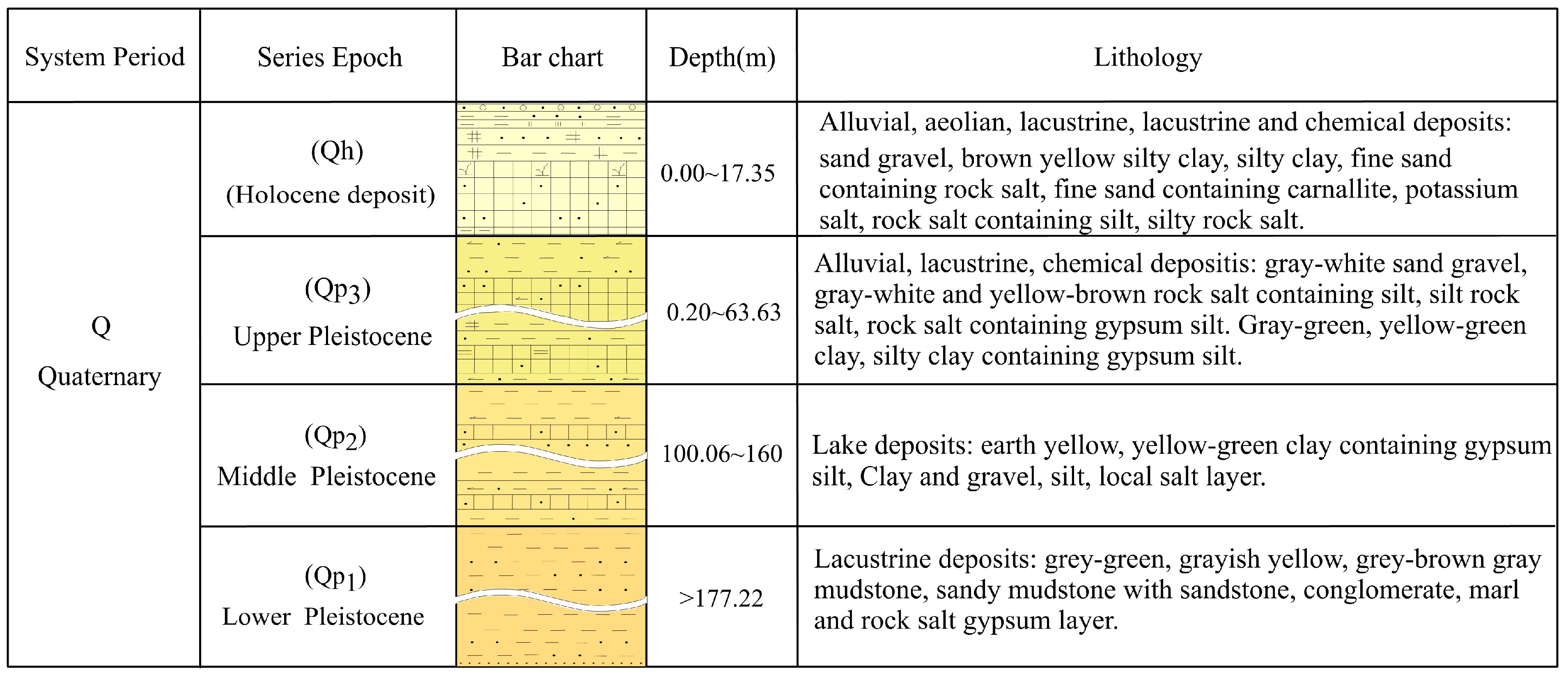
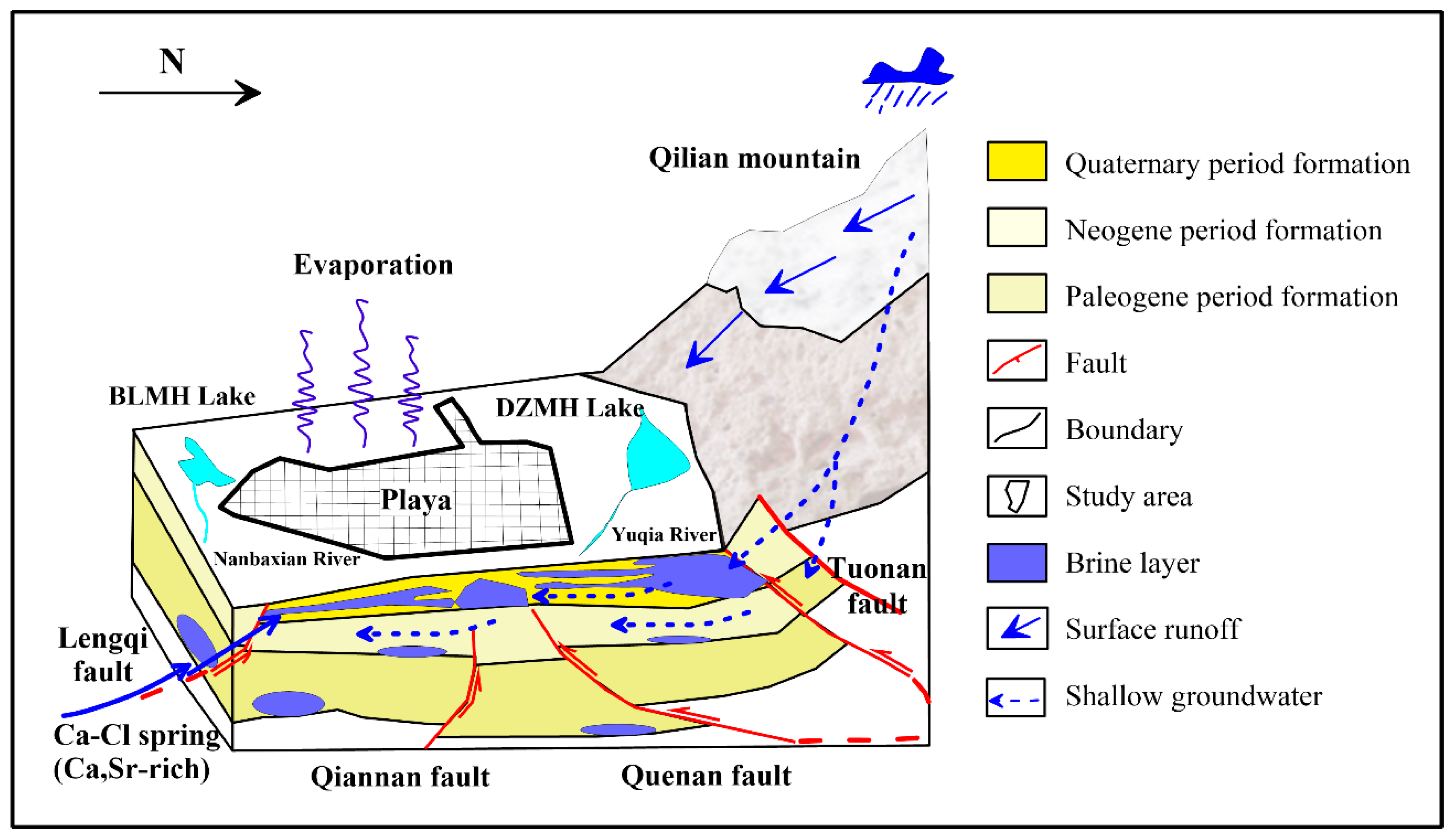
2. Geology and Hydrological Setting

The QB, situated in the northwest of Qinghai Province, is a deep alpine basin formed by the giant mountain discontinuity depression structure in the northeastern part of the Qinghai–Tibet Plateau, and it is one of the three major inland basins in China. The Qilian Mountains in the north encompass the basin, the Kunlun Mountains in the south, and the Altun Mountains in the west. Tectonic movements along the Kunbei fault, the Zongwulong fault, and the Altun fault form a catchment basin spreading in the northwest–southeast direction [17,18,19,20]. The terrain within the basin is relatively flat, and in the lower-lying areas between the hills and the deserts, closed inland salt lake secondary basins of varying sizes are formed. These salt lake secondary basins are the main accumulation areas in QB, where large areas of loose Quaternary deposits and chemical salt deposits occur, thereby providing corresponding spaces for the occurrence of underground brine.
The study area is located in the Mahai (MH) Basin, a secondary tectonic basin northeast in QB (Figure 1a). The geographical coordinates are 94°03′–94°16′ E, 38°03′–38°15′ N. The study area is north of Saishiteng Mountain, and the south side is a hilly basin and plain covered with saline soil. The majority of the study area is a flat salt lake sedimentary plain exhibiting a topography that is high at the borders and low in the center. It is a closed basin where the major water streams and salts from the surrounding area converge. The BLMH represents a secondary salt-forming basin from the Pleistocene–Holocene epoch, which is an integral component of MH (Figure 1b). Therefore, the study area’s stratigraphy, structure, and sedimentary characteristics basically follow the geological characteristics of MH [21]. The tectonics of BLMH are relatively straightforward, dominated by Cenozoic folds, with the development of fold and fracture tectonics. All the faults are active neotectonic faults which have existed since the late Himalayan period. Geophysical data confirm hidden faults on the north side of BLMH. The largest one is the Tuonan fault (F1), which develops parallel to the Saishiteng Mountain fold belt, and the faults generally strike NW. According to the remote sensing data, there are two main fault zones in the basin, the northeast Quenan fault (F2) and the northwest Qiannan fault (F3), which constitute the main structures limiting the BLMH. In the south of the study area, there is also a NW-trending Lengqi fault (F4). The sedimentary characteristics of the Quaternary strata, the characteristics of ore bodies, the salt deposits, and the brines in the study area are evidently influenced by the fracture zones. It is apparent that faults are integral to the processes of mineralization and inter-brine seepage within the study area.
Quaternary strata are dominant in BLMH, with the Holocene (Qh) and Late Pleistocene (Qp3) strata exposed at the surface [20]. The Middle Pleistocene (Qp2) and Early Pleistocene (Qp1) strata are only observed in the middle and lower portions of the boreholes. The relationships between the various stratigraphic units are primarily defined by the presence of conformable and unconformable contacts (Figure 2). A comparative analysis of Quaternary sedimentary features indicates that the BLMH has undergone a transition from deep to shallow water conditions. Alluvial facies, shallow lacustrine facies, and lacustrine facies were mainly developed in the Early Pleistocene (Qp1), when salt lake facies were rarely developed. The Middle Pleistocene (Qp2) mainly developed shallow lacustrine facies, mainly silty (gypsum) clay with silt and rock salt facies. The strata developed in the Late Pleistocene (Qp3) consist of shallow lake facies, and it was mainly clay, silt and silt clay interbedded lithofacies. In comparison to the Middle Pleistocene, the extent of the salt lake facies was expanded, while the area of lacustrine facies was reduced. Holocene (Qh) strata developed only in the central and eastern regions, mainly as salt lake facies and lacustrine facies, whose development area was reduced. The lithology was medium-coarse-grained salt containing silt and locally containing carnallite and potassium salt [22,23]. As a whole, the climate changed from a relatively humid semi-arid environment in the Early Pleistocene to an arid environment in the Holocene, and the lake basin area changed from middle (Qp1) to large (Qp2–Qp3) to small (Qh).
The BLMH has typical arid climate characteristics of an inland desert type. The rivers developed around the study area are all internal water systems. Yuqia River is the largest perennial river in MH, originating from the north slope of Daken Osaka and the south slope of Tuergen Osaka [24]. The river is mainly fed by ice melt water and groundwater in high mountain areas. The Nanbaxian River is formed by groundwater overflowing on the surface. From the source to the downstream, springs can be seen along both sides of the river bed in a linear pattern, flowing into BLMH Lake. The BLMH Lake is the only surface water body in the region and belongs to the final drainage area in the regional hydrogeological unit. According to the occurrence conditions, hydrological properties, and hydraulic characteristics of groundwater, regional groundwater can be divided into four basic types: loose rock pore water, chemical rock inter-brine, clastic rock fracture pore water, and bedrock fracture water [25]. The inter-brine studied in this paper mainly occur in the Quaternary Holocene–Mid-Pleistocene salt-bearing strata, which constitute a nearly horizontal lacustrine sedimentary system, in which the salt minerals, such as rock salt and gypsum, are dominant. The structure of these sediments is loose, the pores and gaps are fully developed, and the stratum thickness is significant, providing spatial primary conditions for groundwater storage. The dry climate conditions accelerate the evaporation and consumption of groundwater, and these favorable external conditions promote brine formation.

3. Sampling and Analytical Methods

Ten samples of inter-brines were collected from newly drilled boreholes in July 2023. The sampling depth is generally about 10 meters. As the same time, one sample of BLMH Lake water and three samples of Nanbaxian River waters were collected. The distribution of sampling points is shown in Figure 1c. The collected brine and water samples were subsequently filtered through a 0.45 μm filter (cellulose acetate) into pre-cleaned 200 mL bottles. Parafilm was used to seal the bottle tightly to avoid isotopic fractionation.
The content in samples were determined at the Analysis and Test Center of Qinghai Salt Lake Research Institute, Chinese Academy of Sciences. All analyses were conducted within one week of sampling. The concentrations of K+, Na+, Ca2+, Mg2+, Cl, SO42−, and Sr2+ were determined using inductively coupled plasma–optical emission spectrometry (ICP-OES), with an error of less than 5%; trace elements B3+, Li+, and Br were determined by inductively coupled plasma–mass spectrometry (ICP-MS) with an analytical accuracy of over ±5%. The Sr2+ was determined by atomic absorption spectrometry (GBC-908) with an analytical accuracy of over ±5%. The error of ion balance is within ±5%, which indicates that the test results are reliable.
The H-O-Sr isotopes were determined in the Analytical Testing Research Center of the Beijing Institute of Nuclear Industry and Geology. The instruments used were a Flash EA elemental analyzer and MAT253 mass spectrometer. H isotopes were determined by the zinc reduction method (analytical precision better than 1.0‰), O isotopes were determined by the carbon-dioxide–water balance method (analytical precision better than 0.2‰), and the results were standardized to the standard mean ocean water (SMOW). The final results of the obtained hydrogen–oxygen isotopic ratios were expressed as δDV-SMOW (‰) and δ18OV-SMOW (‰). The analytical precision of the strontium isotopic ratios was ±1.0 × 10⁻⁶ (2σSD), and the mass fractionation corrections for all Sr isotopic ratios were based on 86Sr/88Sr = 0.1194, with analytical errors for each sample in the ±2.0 × 10⁻⁵ (2σSD) range for each sample.

4. Results

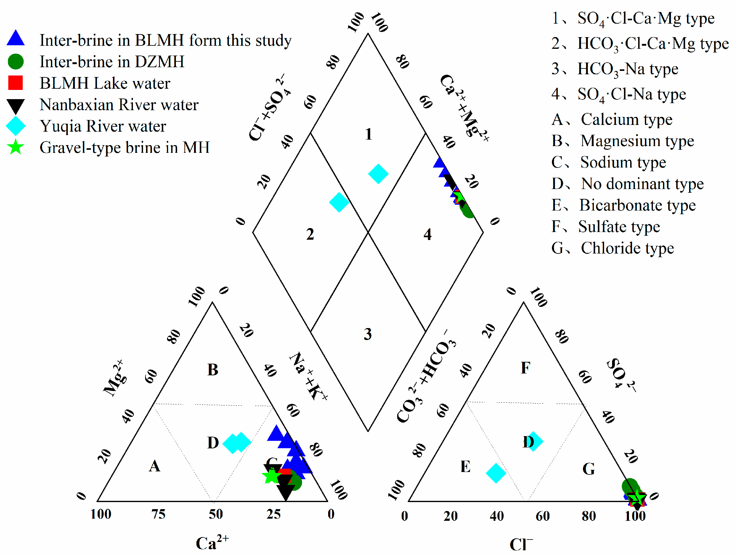
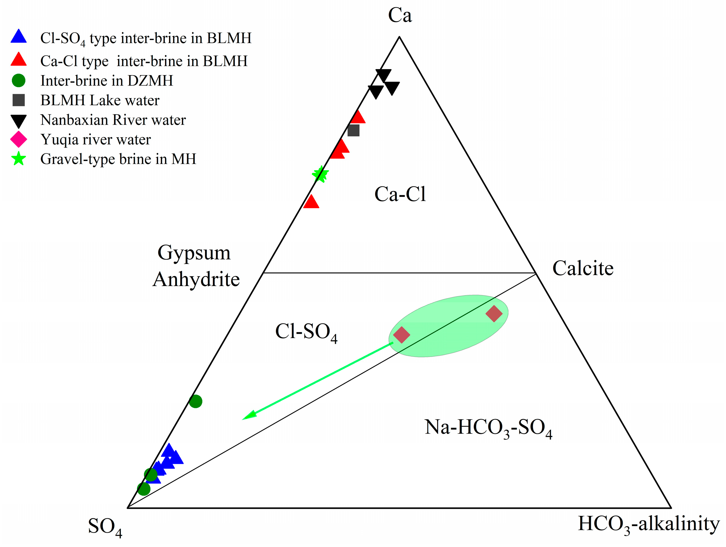
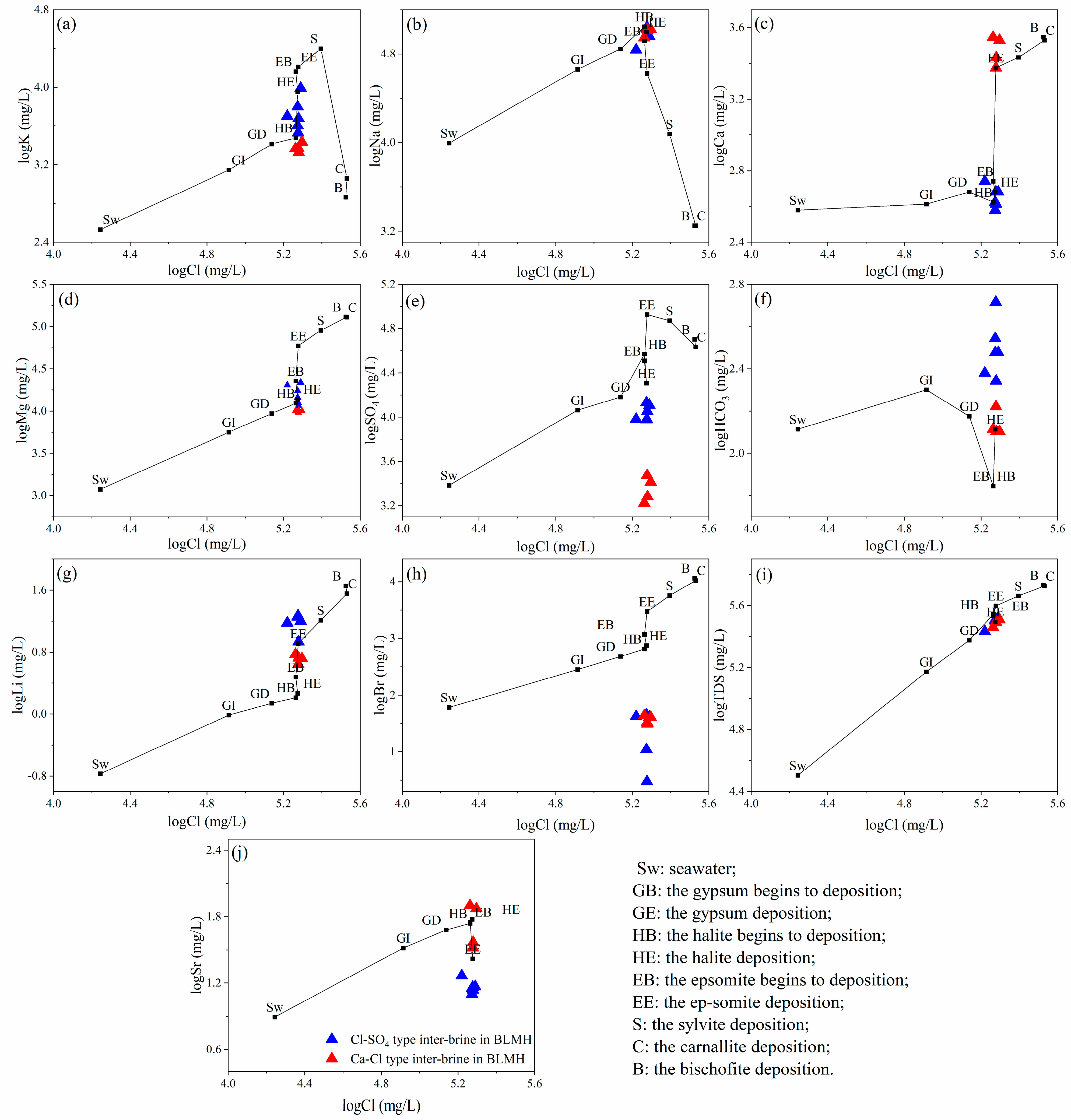
4.1. Chemical Composition of Brine

The chemical compositions of all the water samples are shown in Table 1. The pH of the brine samples was 7.40~8.07, and the total salt content (TDS) was 271.00~331.00 g/L (only ZK8024 and ZK8431 were lower than 300 g/L). These values indicate a weakly alkaline brine with a high degree of mineralization. The Na+ cation was dominant at 68.80~110.00 g/L, and the Cl anion was dominant at 166.00~198.09 g/L. The pH of BLMH Lake water was 7.32, and the TDS was 252.50 g/L. The Na+ cation was dominant at 80.50 g/L, and the Cl anion was dominant at 157.00 g/L. The pH of Nanbaxian river samples were 7.39~7.90, and the TDS were 73.85~153.70 g/L. The Na+ cation was dominant at 23.90~46.80 g/L, and the Cl anion was dominant at 44.18~84.55 g/L.
Compared with data from previous studies, the water of Yuqia River [26] was found to be relatively enriched in Ca and HCO3. The inter-brine in the northern part of the study area has chemical characteristics similar to those of Dezong Mahai (DZMH) inter-brine [27]. In contrast, the inter-brine in the south part of the study area and the water of Nanbaxian River and BLMH Lake have similar chemical characteristics to anticlinal brine in Lenghu and gravel-type brine in MH. This difference in the chemical characteristics may be due to a different type of genesis.
The Piper diagram shows the hydrochemistry of the water samples in MH (Figure 3). The hydrochemical type of the inter-brine in the study area, the water of the Nanbaxian River and the BLMH Lake, the inter-brine in DZMH, the anticlinal brine in Lenghu (LH), and the gravel-type brine in MH are of the Cl-Na type [28,29,30]. The water of the Yuqia River is of the HCO3-SO4-Na type. The average Li content of inter-brines in the northern part of the study area (15.63 mg/L) was higher than that of inter-brines in the southern part (5.20 mg/L) and reached the industrial index of comprehensive utilization (13.1 mg/L). The Br content was 32.11 mg/L on average, which is well below the limit for standard industrial use (150.00 mg/L) and much lower than the seawater (67.00 mg/L), which is quite normal for a typical inland salt lake. The average Sr content of inter-brines in the northern part of the study area (14.72 mg/L) and the southern part (55.94 mg/L) was higher than that of Yuqia River (0.54 mg/L). This suggests that the brine was recharged by deep water with high strontium content [27].

4.2. Isotope Composition of Brine

The H and O isotopes analysis results of the inter-brines showed a variation in δDV-SMOW values between −41.20 to −5.50‰, and the δ18OV-SMOW values varied from −2.00~6.50‰. The δDV-SMOW values of the BLMH Lake and the Nanbaxian River are 1.30 and −2.00‰, and the δ18OV-SMOW values are 3.09 and 7.00‰. Different water samples from MH had different hydrogen and oxygen isotope values. Those in the Yuqia River waters were −69.85 and −9.92 ‰; those in DZMH inter-brine were −21.5 and 2.07‰; those in LH anticlinal brine were −37.45 and 3.18‰; those in MH gravel-type brine were −78.92 and −11.16‰, respectively.
The 87Sr/86Sr ratio of the Yuqia River is 0.71151~0.71183 [31]. The 87Sr/86Sr ratio of rock salt and gypsum samples ranged from 0.71126~0.71153 in MH, and the strontium isotopic composition of Paleogene terrigenous salt rocks ranged from 0.7115~0.7116 [32,33]. The 87Sr/86Sr ratio (0.71137~0.71145) of confined brine in MH is similar to that of surface Tertiary halite (0.71138~0.71145), indicating that this halite provides a solute source for the brine. The 87Sr/86Sr ratio of inter-brines in the study area ranged from 0.71164~0.71176, with an average value of 0.711687 (n = 10), which is higher than the 87Sr/86Sr ratio of rock salt and gypsum in MH. This indicates that the brine may be affected by the mixed recharge of water from different sources (Figure 4a).

5. Discussion

5.1. Hydrochemical Compositions

Based on the chemical divide principle established by Hardie and Eugster, three hydrochemical types are identified: Cl-SO4, Ca-Cl, and Na-HCO3-SO4 types [34]. The hydrochemical types of inter-brines in the study area are classified as Cl-SO4 and Ca-Cl types, with a line from ZK7423-ZK8024 as the boundary, between Cl-SO4-type brine in the north and Ca-Cl-type brine in the south. The DZMH inter-brines are classified as Cl-SO4 type, and the water of the Nanbaxian River and BLMH Lake, anticlinal brine in LH, and gravel-type brine in MH are classified as Ca-Cl-type. The route of Yuqia River water is at the boundary between the Na-HCO3-SO4-type and the Cl-SO4-type, which is close to the inter-brine in the Ca-SO4-HCO3 plot, suggesting that the Yuqia River water serves as a primary recharge source for the inter-brine in BLMH (Figure 5).
The seawater evaporation trajectory (SET) can reflect the sequence of salt precipitation in natural water bodies during evaporation and the origin of brine in sedimentary basins. The Cl as a conservative element in groundwater circulation can be used to explain the origin of groundwater and hydrogeochemical processes [35,36,37].
In a log K vs. log Cl plot (Figure 6a), data for Cl-SO4-type brine in the study area are located near the SET, indicating that K in the brine may come from leaching of halite and sylvite. Data for Ca-Cl-type brine are located below SET, indicating that K is relatively deficient compared to Cl. Potassium in this brine may be derived from the partial leaching of halite and sylvite. Still, the dissolved amount is lower than Cl-SO4-type brine, so there is more potassium potential in the northern part of the study area. In a log Na vs. log Cl plot, data for Cl-SO4 and Ca-Cl-type brine are located near SET (Figure 6b), indicating that the Na of the brine may come from the leaching of rock salt. In a log Ca vs. log Cl plot (Figure 6c) and a log Mg vs. log Cl plot (Figure 6d), data for Cl-SO4-type brine are located near SET. Because the dissolution of rock salt does not affect their content, Ca and Mg in the brine must derive from other minerals. For basin fluids, whether seawater evaporation or rock salt dissolution, Ca enrichment is related to the strong water–rock interaction experienced by the fluid [37]. At the same time, Ca is enriched with respect to Cl, and Mg is deficient relative to Cl in Ca-Cl-type brine. This indicates that Ca-Cl-type brine may be recharged by deep water, while dolomitization contributes to a decrease in Mg content and an increase in Ca content. In a log SO4 vs. log Cl plot (Figure 6e), data for Cl-SO4 and Ca-Cl-type brine are located below SET, suggesting that SO4 has a deficit relative to Cl. It is hypothesized that the brine may have been replenished by deep water, and sulfate reduction caused SO4 to decrease. In a log HCO3 vs. log Cl plot (Figure 6f), data for Cl-SO4- and Ca-Cl-type brine are located above the SET (Figure 6f). This indicates that HCO3 is relatively enriched compared to Cl, and the brine may be recharged by surface water, but Cl-SO4-type brines are affected by a higher proportion of fresh water. Lithium does not participate in diagenesis and is mainly enriched in authigenic magnesite and Li-bearing silicates. In a log Li vs. log Cl plot (Figure 6g), data for Cl-SO4-type brine are located above SET. This indicates that Li is more enriched than Cl- and Ca-Cl-type brine and should be given more attention in future research and resource evaluation. The Cl of rock salt leaching water and the mixed water of seawater and atmospheric precipitation is enriched relative to Br. In a log Br vs. log Cl plot (Figure 6h), data for Cl-SO4 and Ca-Cl-type brine are located below the SET, and Cl is enriched relative to Br. This indicates that the brine is derived from atmospheric precipitation recharge, and the primary source of solute is the leaching of rock salt. In a log TDS vs. log Cl plot (Figure 6i), data for Cl-SO4 and Ca-Cl-type brine are located near the SET. This suggests that the brine is subject to intense evaporation and concentration, and the leaching of rock salt is the main factor for the increase in the salinity of the brine. In a log Sr vs. log Cl plot (Figure 6j), data for Cl-SO4 brine are located below the SET, i.e., Sr is deficient relative to Cl. This indicates that the recharge effect of surface water has low strontium content. Strontium of Ca-Cl-type brine are located above the SET. This indicates that Sr is relatively enriched compared to Cl. It is inferred that the brine has deep source characteristics; the deep water with high strontium rises along the fault to recharge the brine [38,39].
The ternary phase diagram of Ca-SO4-HCO3 can reflect the evolution of the chemical composition of groundwater. The possible sources of sulfate in the brines are oxidation of sulfide minerals or natural sulfur, leaching of wind-blown gypsum, and dissolution of buried gypsum/anhydrite [40,41]. As shown in Figure 5, Cl-SO4-type brine in the study area and DZMH inter-brine fall in the Cl-SO4 region and cluster toward the corner SO4. This suggests that the brine received the input of dissolved gypsum and anhydrite. The Ca-Cl-type brine, water of BLMH Lake and Nanbaxian River, anticlinal brine in LH, and gravel-type brine in MH fall in the Ca-Cl region. This indicates that the above brine may be recharged by deep water, for which the fault provides a potential channel for the upward movement.
In conclusion, evaporation, concentration, and rock salt dissolution control the main hydrogeochemical processes of the inter-brine in the study area. The brine solutes are mainly derived from the dissolution of minerals such as halite, sylvite, and gypsum. The extensive development of halite and gypsum in the Quaternary strata in the study area also indirectly confirms this conclusion. The brine is all derived from atmospheric precipitation recharge but are affected by water recharge from different depths, consistent with the geological characteristics of deep and hidden faults in the study area.

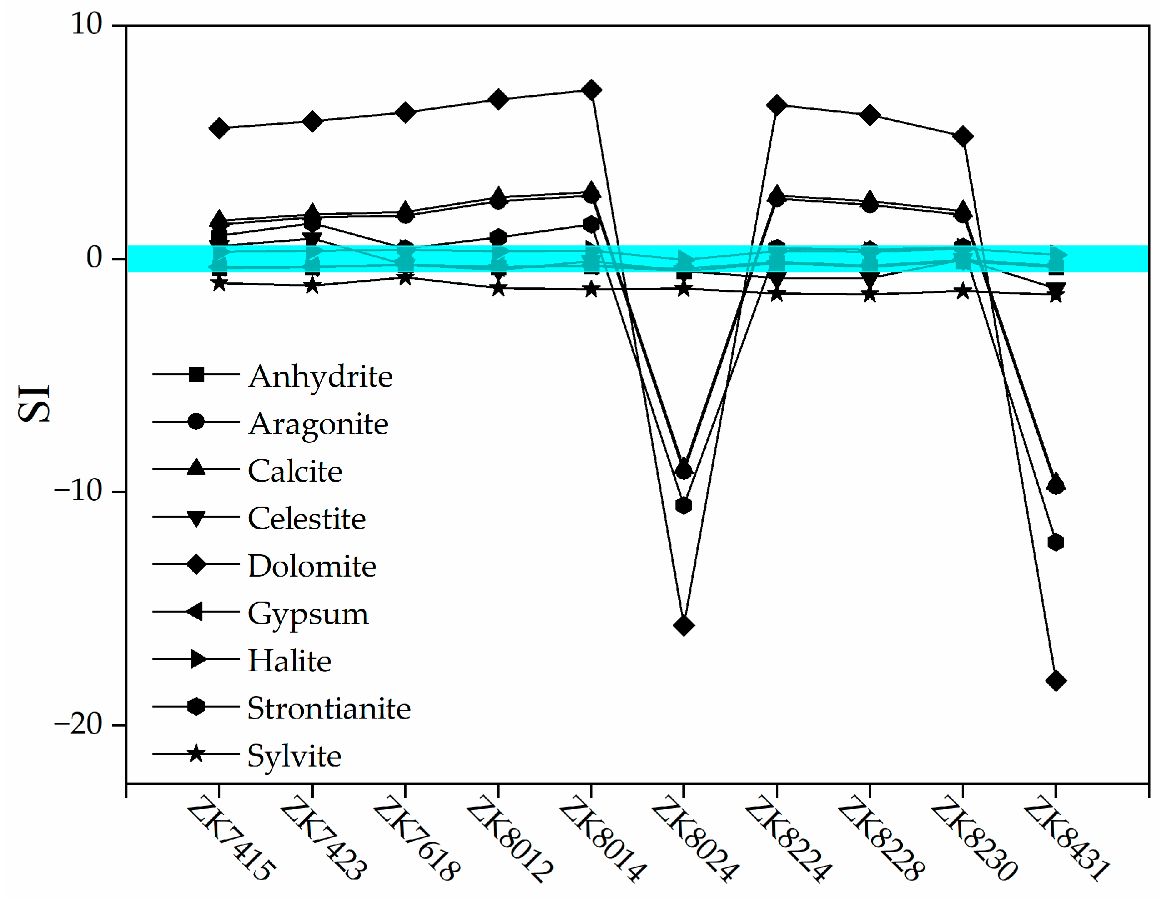
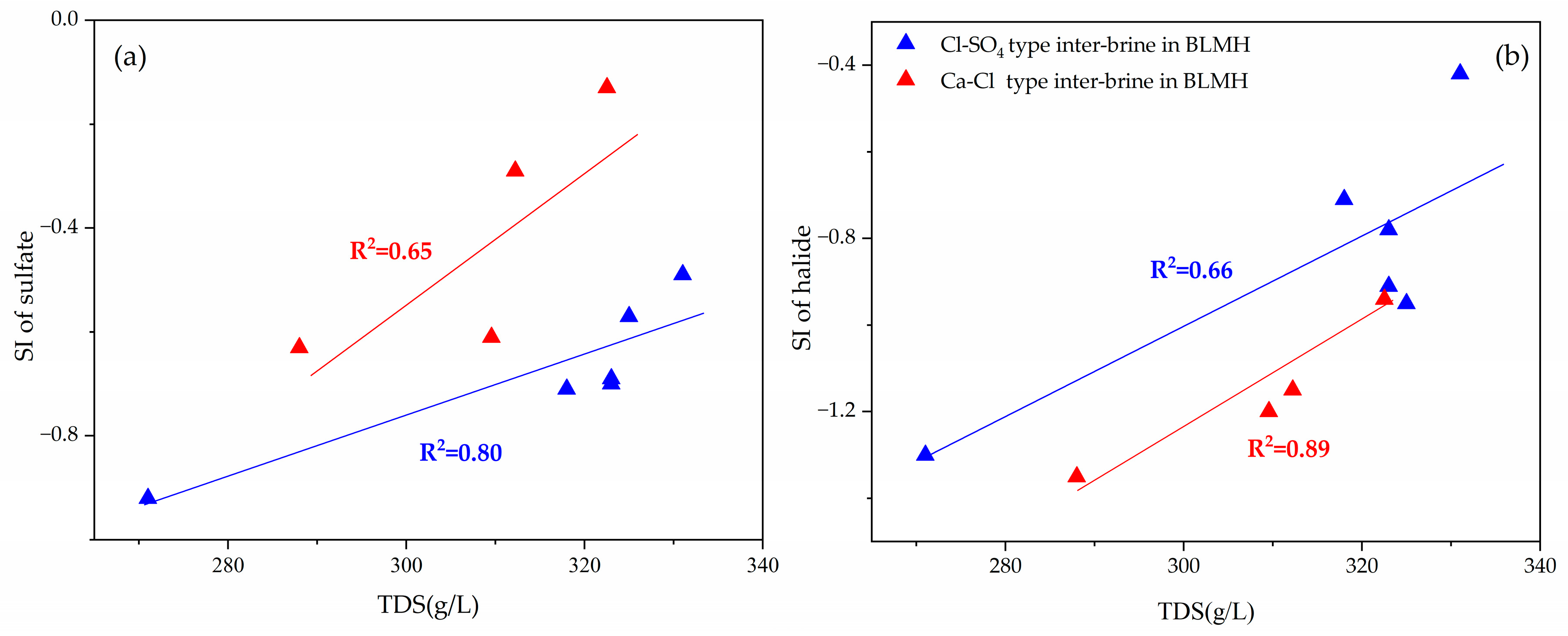
5.2. Hydrogeochemical Interactions

(1)
Ion Exchange Interaction
The (Ca2++Mg2+-SO42−-HCO3) vs. (Na++K+-Cl) plot is usually used to determine whether an ion exchange interaction occurs. It is suggested that groundwater near the Y = −X line has experienced a strong ion exchange interaction [42]. Most of the inter-brine fall near the Y = −X line (Figure 7a), suggesting that the weakly alkaline environment promotes an ion exchange interaction in the brine. The chloro-alkaline index (CAI) index can be used to analyze the direction and strength of ion exchange in groundwater [43]. The calculation formulas are expressed by Equations (1) and (2):
CAI 1 = ( Cl K + Na + ) / Cl
CAI 2 = ( Cl K + Na + ) / ( SO 4 + HCO 3 )
When K+ and Na+ are adsorbed, and Ca2+ and Mg2+ are desorbed in groundwater, CAI is positive; otherwise, CAI is negative. The larger the CAI absolute value, the higher the degree of cation alternating adsorption occurs. As can be seen in Figure 7b, CAI of inter-brine is greater than zero. K+ and Na+ from brine are adsorbed, and their concentrations decrease, while Ca2+ and Mg2+ concentrations increase due to desorption. This indicates that ion exchange interaction plays a major role in controlling the chemistry of inter-brine in the study area.
(2)
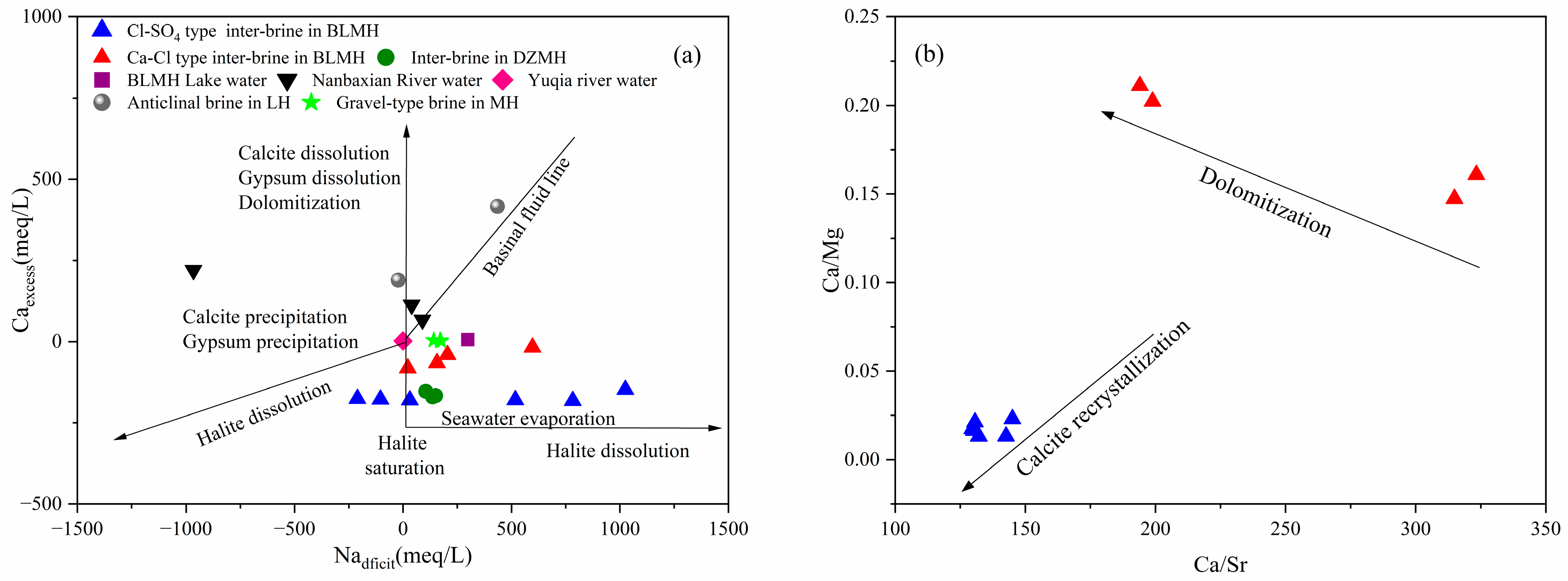
Water–rock Interaction
Studies have shown that water–rock interaction in sedimentary basins mainly includes four processes: albitization of plagioclase and potassium feldspar, dissolution or precipitation of halite, dissolution or precipitation of gypsum, anhydrite or calcite, and dolomitization [44,45]. Groundwater mineral saturation index (SI) can reflect the degree of water–rock interaction and indicate the saturation state of minerals in groundwater, which is defined as follows:
SI = log ( IAP / K )
The IAP is the ionic activity product, and the K is the equilibrium constant of the mineral at saturation temperature. An SI between −0.5 and 0.5 is generally believed to be a state of dissolution equilibrium; SI > 0.5 indicates that minerals are in the oversaturated state, i.e., minerals are stable with respect to solution and tend to precipitate; SI < −0.5 indicates that minerals are not in equilibrium with the solution, and tend to dissolve [46,47].
Based on the PHREEQC 3.7.3 program, the SI values of halite, sylvite, gypsum, anhydrite, aragonite, calcite, celestite, dolomite, and strontianite in the inter-brine were calculated. As shown in Figure 8, halite, gypsum, and anhydrite are close to equilibrium with the brine in this area (SI mean values are 0.30, −0.26, and −0.31, respectively). Sylvite is always in the unsaturated state (SI mean value is −1.27), which indicates that the brine will dissolve it to a large extent. The saturated states of aragonite, calcite, and dolomite in the majority of brine samples indicate that the dissolution of calcite and dolomite serves as the primary source of Ca2+, Mg2+, and HCO3 in the brine. Celestite is in a state not far from equilibrium, whereas strontianite is in a state of saturation. This indicates that the source of Sr2+ may be related to the dissolution of celestite, which is consistent with the geological environment of celestite in the northeast QB. There is a strong correlation between SI values of inter-brine, halide minerals, and sulfate minerals (Figure 9a,b). This suggests that the brine mainly leaches minerals such as halite, sylvite, gypsum, and anhydrite, which are typically present in the Holocene and Middle Pleistocene salt-bearing strata in the study area.
The Nadeficit chart can be used to describe the composition of brine and the water–rock interaction [45,48]. The specific equations are as follows:
Ca excess = Ca meas Ca / Cl sw × Cl meas × 2 / 40.08
Na deficit = Na / Cl sw × Cl meas Na meas / 22.99
In the formula, Cl is used to standardize the concentration of cation because it is typically not affected by water–rock interaction; Cameas, Nameas, and Clmeas indicate the concentration of ions in the fluid; (Ca/Cl)sw and (Na/Cl)sw indicate the ion concentration ratio of seawater.
In the Caexcess vs. Nadeficit plot (Figure 10a), the data of the vast majority waters in the MH Basin are located between the trend line of halite precipitation and the trend line of dissolution of calcite/gypsum and dolomitization. Elucidate the synergistic impact of halite dissolution and water–rock interactions on the brine in the study area. The Ca-Cl-type inter-brine, the water of Nanbaxian River and BLMH Lake, the anticlinal brine in LH, and the gravel-type brine in MH are located near the basinal fluid line. This suggests that ion exchange interaction has occurred in these brines. In sedimentary basins, dolomitization is a common diagenetic process leading to depletion of Mg and enrichment of Ca in the fluid. However, as can be seen from the Ca/Mg vs. Ca/Sr plot [49] (Figure 10b), the dolomitization influence on the Ca-Cl-type brine is significantly stronger than that in Cl-SO4-type brine. This indicates that dolomitization contributes significantly to the composition of the Ca-Cl-type brine. Summarizing, halite dissolution, ion exchange interaction, and dolomitization affect the inter-brine in the study area.

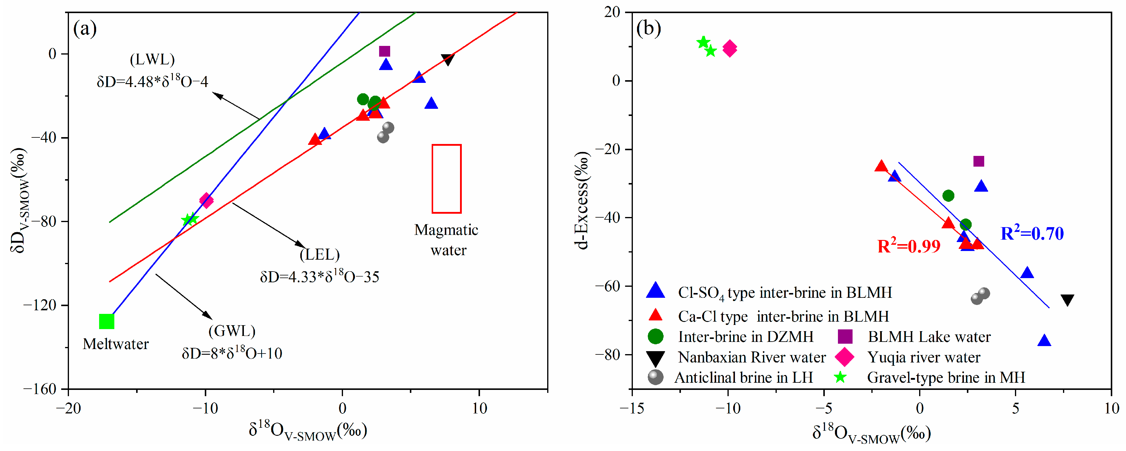
5.3. Hydrogen and Oxygen Isotopes

The hydrogen and oxygen isotopes can give important indications in the study of the salt-forming evolution of underground brine and their material sources [50,51]. The H and O isotopes of inter-brine were all at the lower right of the Global Water Line (GWL: δD = 8 δ18O + 10) and the Local Water Line (LWL: δDV-SMOW = 8.29 δ18OV-SMOW + 7.44) [29,30,50], far from the reference range of magmatic water (Figure 11a), suggesting that the source of brine may be atmospheric precipitation or ice and snow meltwater. The hydrogen and oxygen isotopes of Yuqia River water, DZMH inter-brine, and inter-brine in the study area are also located near the local evaporation line (LEL: δDV-SMOW = 4.33 δ18OV-SMOW − 35). This suggests that they may have been subjected to strong evaporation and that these water bodies may have come from snowmelt in Qilian Mountains.
The hydrogen and oxygen isotopes of different water sample types from the MH basin show two very different clusters, one that falls exactly on the GWL and the other that is closer to the LEL (Figure 11a). The δDV-SMOW and δ18OV-SMOW values increase from one cluster to another, i.e., δDV-SMOW and δ18OV-SMOW gradually increase from recharge to evaporation, and their changes conform to the evolution trend of δDV-SMOW and δ18OV-SMOW in a closed environment, as proposed. These findings suggest strong evaporation and concentration in inter-brine. The inter-brine in the study area has prominent characteristics of “low deuterium and high oxygen.” This feature may be the result of evaporation and water–rock interactions. At the same time, there is a positive correlation between δ18OV-SMOW and δDV-SMOW in brine in the study area, indicating that water–rock interactions are not the leading cause of the positive deviation of δ18OV-SMOW. The results show that the inter-brine in BLMH is mainly characterized by evaporation concentration and isotopic fractionation.
Due to different water vapor sources, migration processes, and meteorological factors, global atmospheric precipitation presents variations in δDV-SMOW and δ18OV-SMOW fractionation, resulting in differences between GML and LML in slope and intercept. The deuterium is defined as d-Excess = δDV-SMOW − 8δDV-SMOW [52], which can measure the degree of departure from hydrogen–oxygen isotope balance fractionation in atmospheric precipitation and can indicate the intensity of the fractionation during evaporation. The deuterium surplus value in water is mainly affected by water source and water–rock interaction [53,54]. The d-Excess value of inter-brine in the study area ranges from −76.10 to −24.80‰, with an average value of −45.22‰. The linear relationship between δ18OV-SMOW and d-Excess value presents a well-fitting negative correlation (Figure 11b). It is confirmed that the intense evaporation and concentration leads to the enrichment of hydrogen and oxygen isotopes in inter-brine, which is related to the local arid climate and scarce rainfall. The water–rock interaction also occurs in inter-brine, and isotopic exchange occurs after the atmospheric precipitation is injected into the ground, which increases the δ18OV-SMOW value in inter-brine and ultimately leads to a decrease in the d value, proportional to the extent of water–rock interaction. The above results show that the “low deuterium and high oxygen” inter-brine in BLMH originates from atmospheric precipitation or meltwater of ice and snow and is further subjected to water–rock interactions, evaporation, and concentration.

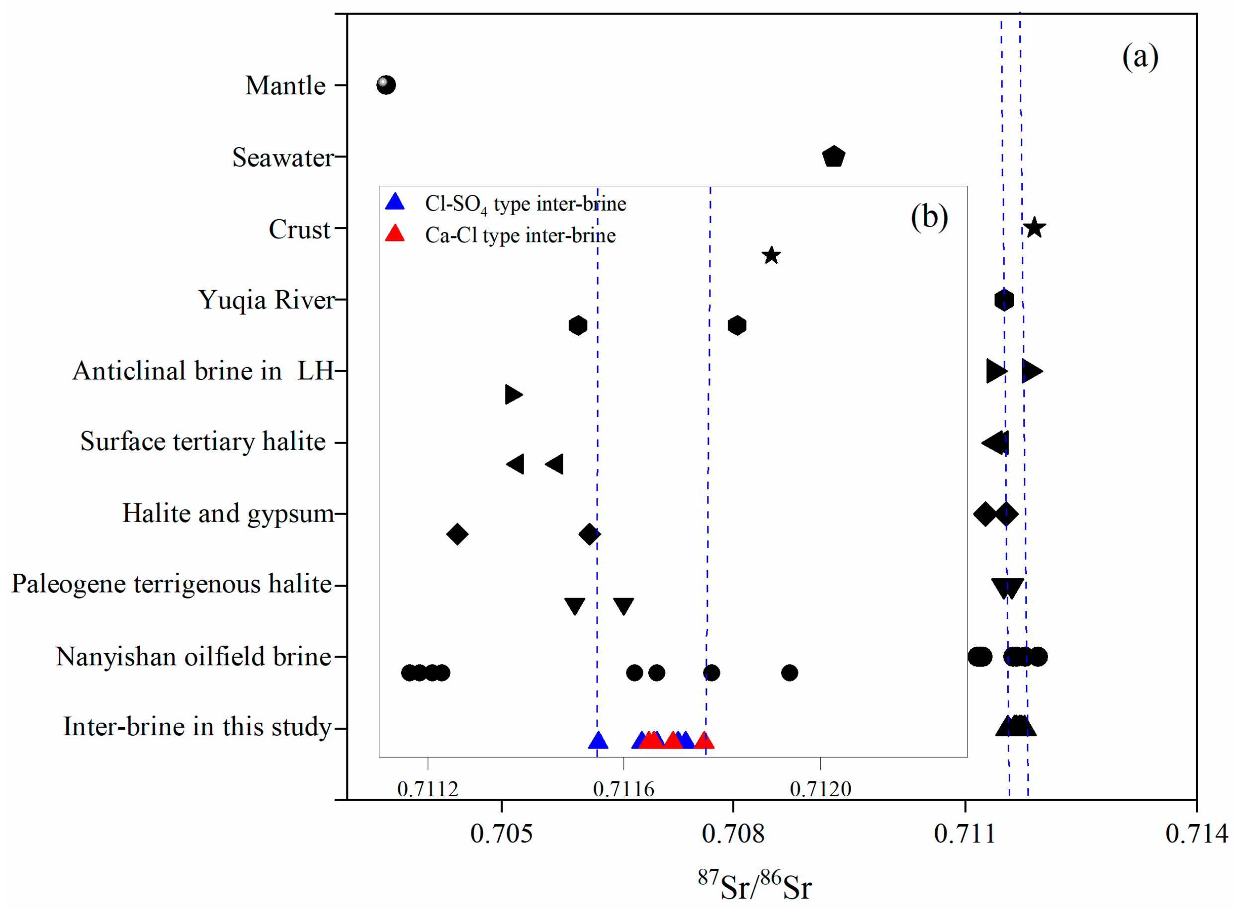
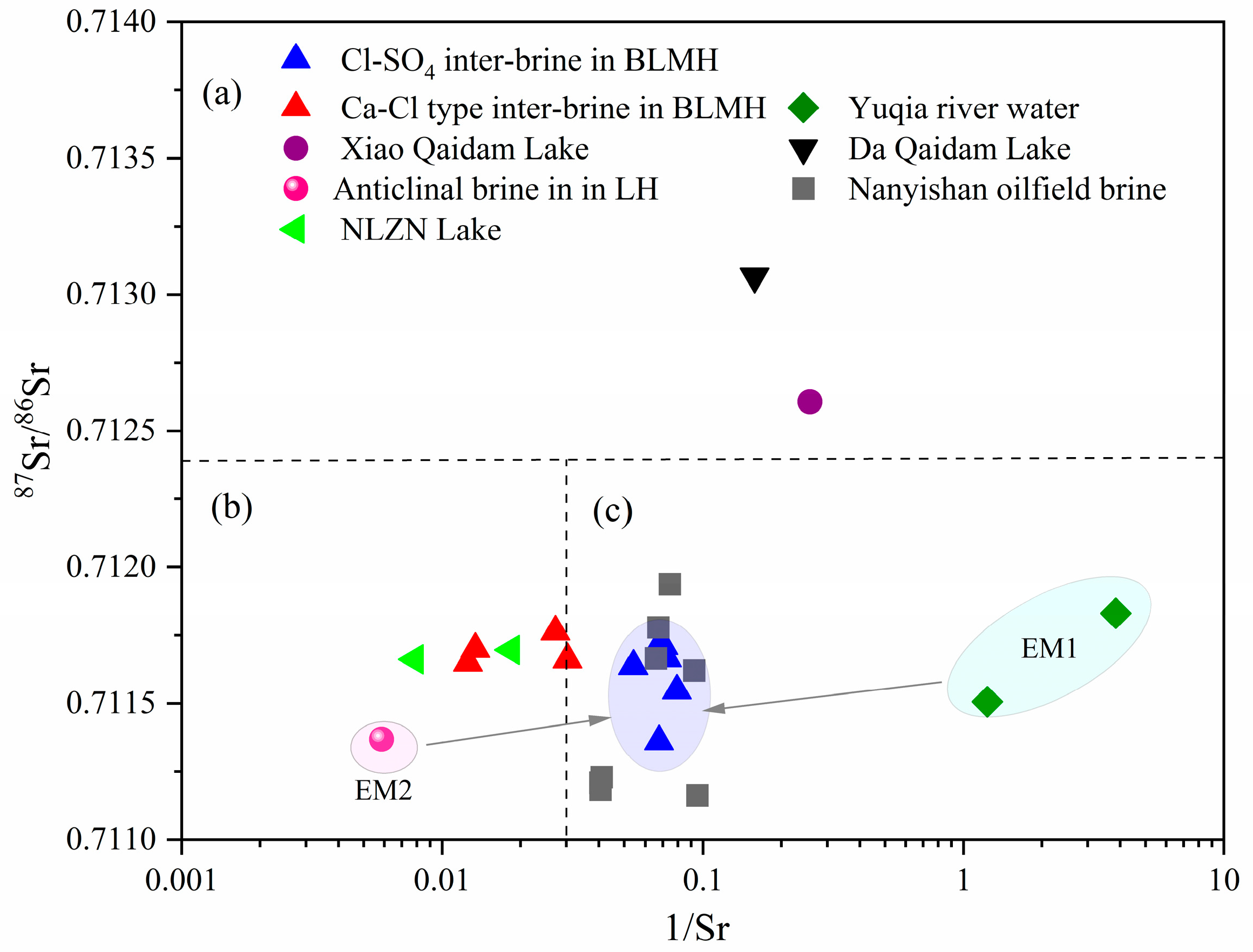
5.4. Strontium Isotopes

Strontium isotopic ratios are similar to the isotopic composition of the interacting bedrock and are not affected by fractionation or mineral precipitation. It can provide important information about the source of solute, water–rock interaction, and water-mixing ratio of different end members [38,39,55,56].
According to the strontium content and its isotope ratio, three geochemical regions were drawn (Figure 12). The water of the Da Qaidam Lake and the Xiao Qaidam Lake showed high 87Sr/86Sr values. The Ca-Cl inter-brine in the study area and the Niulang Zhinv Lake water showed similar high Sr content and low 87Sr/86Sr characteristics, suggesting a common origin. The deep Ca-Cl water rises to the surface along the faults between the Paleogene–Neogene and Quaternary strata. The Cl-SO4-type inter-brine, Nanyishan oilfield water, and Yuqia River water in the study area show low Sr concentration and 87Sr/86Sr.
The Yuqia River is primarily a river formed by the exfiltration of groundwater, with surrounding rocks contributing to the lake basin through processes of weathering and leaching which are facilitated by both groundwater and surface flow. The high 87Sr/86Sr value (average 0.720 ± 0.005) of the strontium isotope in silicate rocks should be the result of the influence of it, so it is speculated that river water is related to the recharge of the water reacting with the surrounding rocks. The 87Sr/86Sr value range is 0.71164~0.71173 between the Yuqia River and the anticlinal brine in LH (Figure 4b). The concentration of Sr in Yuqia River and inter-brine is lower but different from 87Sr/86Sr of halite and gypsum. Therefore, it is speculated that the source of brine in the northern part of the study area is the mixing of the Yuqia River and deep water.
The 87Sr/86Sr value of Cl-SO4-type inter-brine in BLMH should mainly be a mixture of the 87Sr/86Sr value of two end members. To quantify the contribution ratio of Yuqia River and anticlinal brine in LH, the mass balance equation based on 87Sr/86Sr is as follows:
Sr 87 / Sr 86 R × F R + Sr 87 / Sr 86 S × F S = Sr 87 / Sr 86 B
F R + F S = 1
where (87Sr/86Sr)R, (87Sr/86Sr)S, and (87Sr/86Sr)B represent the 87Sr/86Sr values of Yuqia River water, anticline brine, and inter-brine in the study area, respectively; FR and FS are the contribution ratios of Yuqia River water and anticline brine. The results show that the contribution ratio of Yuqia River water to the brine in the northern part of the study area is 58%~77%, which has an essential influence on the formation of brine deposit as the primary recharge source. Anticline brine contribution to this area’s brine is 23%~42%, and the overflow along the deep and large fault zone seriously affects the formation of brine deposits (Table 2). The differences in hydrochemical types and spatial distributions in the study area are fundamentally linked to the recharge and mixing of these two sources, which play a crucial role in forming and evolving Cl-SO4 type inter-brine in BLMH.

5.5. Formation and Evolution

The origin of underground brine is complex, and according to its source, it can be divided into sedimentary brine (preserved after the deposit of saline strata), salt karst brine filtration (surface water or groundwater infiltration into the formation and leaching evaporite), and brine of mixed origin (mixing of different water bodies) [56,57,58]. In the chemical composition of groundwater, there are obvious differences in some ionic ratios of groundwater formed from different sources or under different conditions. Therefore, the ion ratios are often used to determine the origin of groundwater.
The Cl is a relatively stable component in solution, and other ionic ratios do not change due to desalination [36]. The Na/Cl molar ratio can reflect the enrichment degree of sodium salt in brine, the degree of formation sealing, and the degree of formation water activity [59]. The Br × 103/Cl density ratio can not only reflect the degree of brine’s evaporation and concentration but also can be used as a clue to sylvite occurrence [60]. The higher the ion ratio, the higher the concentration of brine. It is generally reported that the Na/Cl molar ratio in standard seawater is 0.87, and the Br × 103/Cl density ratio is 3.4. The coefficient decreases to about 0.86 when rock and potassium salt are present in the groundwater bedrock. The Na/Cl molar ratios of the underground brine in the study area ranged from 0.64~0.90, and Br × 103/Cl density ratios ranged from 0.02~0.25, indicate that inter-brine in the study area is of rock-salt-leaching origin (Figure 13). The low Na/Cl molar ratio is caused by the leaching of halite and sylvite in the formation.
The Ca/Mg molar ratio serves as an indicator of both the sealing duration and the sealing characteristics of underground brine. The calcium magnesium coefficient of deep underground brine is generally greater than 3, and if it is less than 3, it indicates that the underground brine has poor sealing and short sealing time in the salt-bearing formation [61]. The Ca/Mg molar ratio in inter-brine of Cl-SO4 type are 0.01~0.02, indicating that the brine has a short sealing time and poor sealing property. It is consistent with the wide distribution of loose deposits and chemical salt sediments in Quaternary strata. The Ca/Mg molar ratio of Ca-Cl-type inter-brine are 0.15~0.21, which is higher than that of Cl-SO4-type inter-brine. This indicates that inter-brine in the southern part of the study area has a longer formation time, which is consistent with the hydrochemical composition rich in Ca2+, poor in Mg2+ and SO42−, indirectly confirming the existence of deep water recharge. Fault development plays a vital role in the percolation of inter-brine in BLMH.
The SO4 × 50/Cl density ratio can be used to judge the sealing degree of the underground brine reservoir. Sulfate decomposition occurs in a reducing environment, resulting in a decrease in SO4 content. When the value is smaller and closer to 0, it indicates that the sealing and reducing properties of the brine reservoir are more pronounced [62]. The Cl/Mg molar ratio can reflect the degree of water–rock interaction and ion exchange interaction of groundwater during migration [60]. The higher the coefficient, the better the sealing condition of the brine and the longer the sealing time. In the study area, the SO4 × 50/Cl density ratio of Cl-SO4-type brine are 1.86~2.65, the Cl/Mg molar ratio are 2.78~5.54, the SO4 × 50/Cl density ratio of Ca-Cl-type brine are 0.34~0.58, and the Cl/Mg molar ratio are 6.19~6.68. This suggests that the reduction in Cl-SO4-type brine is not complete, the sealing condition is poor, and the sealing time is short. The effect of shallow surface oxidation is more substantial. At the same time, the Ca-Cl-type brine has better sealing conditions and the presence of sulfate reduction, which indirectly confirms that the brine originates from deep water.
Since the Quaternary period, the Himalayan movement is still in continuous progress, the Tertiary fold belt in and around the northern side of MH is relatively stable, and the relative subsidence of BLMH has formed a large number of folds and faults [63,64,65,66,67]. The fifth Neotectonic movement began 30,000 years ago and was a large-scale movement. The BLMH is located in the closed and arid MH. The groundwater originated from the atmospheric precipitation and ice melt water in the high Qilian Mountains in the north and east, and the vast stratified loose deposits provided considerable space for groundwater storage. The dry climate provides a good external condition for the formation of brine, and the dissolution and intense evaporation and concentration of rock salt, potassium salt, and gypsum make the salinity of inter-brine increase and enable the enrichment of mineral elements in the study area. The recharge and mixing of Ca-Cl water and river water is vital in forming and evolving inter-brine in BLMH. In the northern part of the study area, the primary recharge sources are Yuqia River water and shallow groundwater flowing through alluvial fans. The salt marsh zone is affected by sedimentary differentiation, which causes changes in material composition. In the northern part of the study area, the Cl-SO4 type has evolved, with high contents of K and Mg. This has an essential influence on the formation of brine deposits in this area. The Ca-Cl water input along the Lengqi fault zone in the southern part of the study area seriously affect the formation of brine deposits. The differences in hydrochemical types and spatial distribution in the northern and southern regions are fundamentally related to the recharge and mixing of these two sources, i.e., salt rock dissolution and filtration replenishment and deep replenishment contribute to the basic features of inter-brine in BLMH (Figure 14).

6. Conclusions

Based on the study of chemical water characteristics and H-O-Sr isotopic signatures of inter-brine in BLMH, one can draw the following conclusions:
(1)
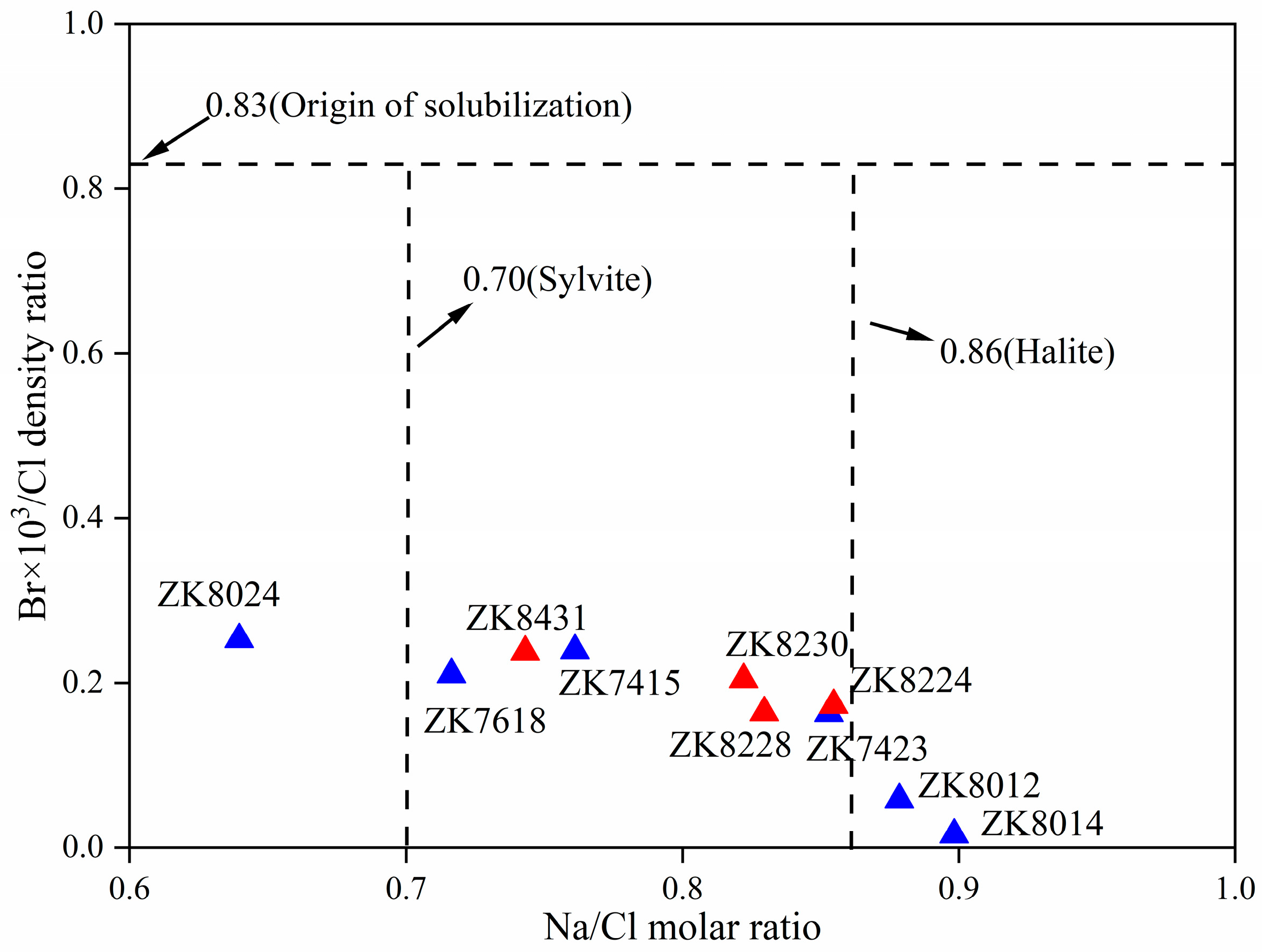
Hydrochemical characteristics suggest that the inter-brine in the study area belong to the high-salinity, weakly alkaline brine. The hydrochemical types are separated by the ZK7423-ZK8024 line, with Cl-SO4-type brine to the north and Ca-Cl-type brine to the north. The brine is mainly controlled by evaporation and concentration, rock salt dissolution, and ion exchange interaction. Dissolution of halite, sylvite, and gypsum provides a solute source for inter-brine.
(2)
Hydrogen and oxygen isotope studies suggest that the “low deuterium and high oxygen” inter-brine in the study area comes from atmospheric precipitation or meltwater of ice and snow. Isotope drift and deuterium surplus phenomena suggests that the brine is subject to water–rock interactions, evaporation, and concentration.
(3)
Studies on strontium isotopes suggests that the recharge and mixing of Ca-Cl water and Yuqia River water play a crucial role in forming and evolving Cl-SO4-type inter-brine in BLMH. A mass balance equation based on strontium isotopes allows for quantitatively estimating the contribution of the Yuqia River water as 58%~77% and the contribution of the anticline brine as 23%~42% in inter-brine.
(4)
The ionic ratios suggests that the inter-brine has poor sealing conditions. The water–rock and ion exchange interactions occur during the migration process. These features are typical of water of rock-salt-leaching origin, which can be summarized as the mixed origin model of “dissolution and filtration replenishment + deep replenishment” in BLMH.

Author Contributions

N.F.: writing—review and editing, writing—original draft, visualization, methodology, investigation, conceptualization. X.Q.: writing—review and editing, funding acquisition. Y.M., D.Z. and C.D.: funding acquisition. T.P., J.C., Z.J., Q.L., E.R. and C.L.: Provide method; funding acquisition. F.Z.: Preliminary data processing and experimental operation. All authors have read and agreed to the published version of the manuscript.

Funding

This research was funded by the Geological Exploration Project of the Qinghai Provincial Geological and Mineral Exploration and Development Bureau (63000000024T000002987), the Open Project of Qinghai Key Laboratory of Salt Lake Geology and Environment (2024-KFKT-B07), the Open Project of Salt Lake Chemical Engineering Research Complex, Qinghai University (2024-DXSSZZ-01), the Geological Exploration Project of Qinghai (2023085027ky002), and the Student Research Training Program of Qinghai University (SRT202430).

Data Availability Statement

All the data are presented in the Tables.

Acknowledgments

The authors provide their most sincere gratitude to the editors and reviewers for their contributions to the improvement of this article.

Conflicts of Interest

Author Xiwei Qin was employed by the company SDI Xinjiang Lop Nur Potash Salt Co., Ltd. The remaining authors declare that the research was conducted in the absence of any commercial or financial relationships that could be construed as a potential conflict of interest.

References

  1. Al Rawashdeh, R. World peak potash: An analytical study. Resour. Policy 2020, 69, 101834. [Google Scholar] [CrossRef]
  2. Liu, C.L.; Lowenstein, T.K.; Wang, A.; Zheng, C.; Yu, J. Brine: Genesis and Sustainable Resource Recovery Worldwide. Annu. Rev. Environ. Resour. 2023, 48, 371–394. [Google Scholar] [CrossRef]
  3. Song, X.; Geng, Y.; Zhang, Y.; Zhang, X.; Gao, Z.; Li, M. Dynamic potassium flows analysis in China for 2010–2019. Resour. Policy 2022, 78, 102803. [Google Scholar] [CrossRef]
  4. Zheng, M.P.; Hou, X.H.; Yu, C.Q.; Li, H.P.; Yi, W.H.; Zhang, Z.; Deng, X.L.; Zhang, Y.S.; Guo, T.W.; Wei, Z.; et al. The leading role of salt formation theory in the breakthrough and important progress in potash deposit prospecting. Acta Geosci. Sin. 2015, 36, 129–139. [Google Scholar]
  5. Choubey, P.K.; Kim, M.S.; Srivastava, R.R.; Lee, J.C. Advance review on the exploitation of the prominent energy-storage element: Lithium. Part I: From mineral and brine resources. Mine. Eng. 2016, 89, 119–137. [Google Scholar] [CrossRef]
  6. Munk, L.A.; Hynek, S.A.; Bradley, D.C.; Boutt, D.; Labay, K.; Jochens, H. Lithium brines: A global perspective. Rev. Econ. Geol. 2016, 18, 339–365. [Google Scholar]
  7. Jurikova, H.; Ring, S.J.; Henehan, M.J.; Neugebauer, I.; Schröder, B.; Müller, D.; Schwab, M.J.; Tjallingii, R.; Brauer, A.; Blanchet, C. Boron geochemistry reveals the evolution of Dead Sea brines. Earth Planet. Sc. Lett. 2023, 622, 118403. [Google Scholar] [CrossRef]
  8. Yuan, J.Q.; Huo, C.Y.; Cai, K.Q. The high mountain-deep basin saline environment—A now cenetic model of salt deposits. Geol. Rev. 1983, 29, 159–165. [Google Scholar]
  9. Liu, W.G.; Xiao, Y.K.; Peng, Z.C.; An, Z.S.; He, X.X. Boron concentration and isotopic composition of halite from experiments and salt lakes in the Qaidam Basin. Geochim. Cosmochim. Ac. 2000, 64, 2177–2183. [Google Scholar] [CrossRef]
  10. He, M.Y.; Luo, C.G.; Yang, H.J.; Kong, F.C.; Li, Y.L.; Deng, L.; Zhang, X.Y.; Yang, K.Y. Sources and a proposal for comprehensive exploitation of lithium brine deposits in the Qaidam Basin on the northern Tibetan Plateau, China: Evidence from Li isotopes. Ore Geol. Rev. 2020, 117, 103277. [Google Scholar] [CrossRef]
  11. Christmann, P.; Gloaguen, E.; Labbe, J.F.; Melleton, J.; Piantone, P. Global lithium resources and sustainability issues. In Lithium Process Chemistry; Elsevier: Amsterdam, The Netherlands, 2015; pp. 1–40. [Google Scholar]
  12. Gilalana, L.A.; Monge, M. Lithium: Production and estimated consumption. Evidence of persistence. Resour. Policy 2019, 60, 198–202. [Google Scholar] [CrossRef]
  13. Baspineiro, C.F.; Franco, J.; Flexer, V. Potential water recovery during lithium mining from high salinity brines. Sci. Total Environ. 2020, 720, 137523. [Google Scholar] [CrossRef] [PubMed]
  14. Zhao, Y.J.; Jiao, P.C.; Wang, M.Q.; Zhang, D.Y.; Zhu, Z.G.; Hu, Y.F. Characteristics, reservoir physical properties and water-rich areas of Li-rich brine in Yiliping Salt Lake, Qaidam Basin. Acta Geol. Sin. 2021, 95, 2062–2072. [Google Scholar]
  15. Kong, F.C.; Yang, Y.K.; Luo, X.; Sha, Z.J.; Wang, J.P.; Ma, Y.J.; Ling, Z.Y.; He, B.Y.; Liu, W.P. Deep hydrothermal and shallow groundwater borne lithium and boron loadings to a mega brine lake in Qinghai Tibet Plateau based on multi-tracer models. J. Hydrol. 2021, 598, 126313. [Google Scholar] [CrossRef]
  16. Ren, Q.H.; Li, B.K.; Zhang, Y.; Wu, H.T. Origin and evolution of inter-brine in the northern Qaidam Basin based on hydrochemistry and stable isotopes. Front. Environ. Sci. 2023, 11, 1106181. [Google Scholar] [CrossRef]
  17. Yin, A.; Harrison, T.M. Geologic evolution of the Himalayan-Tibetan orogen. Annu. Rev. Earth Planet. Sci. 2000, 28, 211–280. [Google Scholar] [CrossRef]
  18. Walter, L.M.; Stueber, A.M.; Huston, T.J. Br-Cl-Na systematics in Illionis basin fluids: Constraints on fluid origin and evolution. Geology 1990, 18, 315–318. [Google Scholar] [CrossRef]
  19. Wang, E.; Burchfiel, B.C. Late Cenozoic right-lateral movement along the Wenquan Fault and associated deformation: Implications for the kinematic history of the Qaidam Basin, Northeastern Tibetan Plateau. Int. Geol. Rev. 2004, 46, 861–879. [Google Scholar] [CrossRef]
  20. Pan, T.; Chen, J.Z.; Ding, C.W.; Ma, Y.L.; Liang, H.; Xue, S.; Zhang, T.; Du, X.C. Supernormal enrichment of lithium, rubidium and cesium in Salt Lake clays of Qaidam Basin and their development potential. Geol. China 2023, 50, 1925–1927. [Google Scholar]
  21. Wang, Z.Q.; Hu, X.M.; Wu, Y.B.; Wang, C.Y. Sedimentology and evolution of sedimentary facies for the Cenozoic in the Mahai Region on the Northern Margin of the Qaidam Basin. Acta Geol. Sichuan 2011, 30, 129–131. [Google Scholar]
  22. Ding, C.W.; Ma, Y.L.; Chen, J.Z.; Ren, W.K.; Du, X.C.; Zhang, T.; Zhao, H.D.; Zhang, F.G. Mineralogy of clay deposits and geochemical characteristics of rare and scattered elements in the Balun Mahai Salt Lake, Qaidam Basin. J. Salt Lake Sci. 2024, 32, 32–39. [Google Scholar]
  23. Wang, W.; Jiang, S.Y.; Ge, W.; Zhang, Q.D.; Liu, T.; Zhang, X.K. Main geological characteristics and genesis of clay-type lithium deposits deposited in lacustrine facies. Bull. Miner. Petro. Geochem. 2024, 43, 64–78. [Google Scholar]
  24. Hu, S.Y.; Zhao, Q.S.; Wang, G.C.; Zhang, J.W.; Feng, J. Hydrochemical dynamic characteristics and evolution of underground brine in the Mahai Salt Lake of the Qaidam Basin Qinghai-Tibet Plateau. Acta Geol. Sin-Engl. 2018, 05, 1981–1990. [Google Scholar] [CrossRef]
  25. Ma, X.; Wang, Q.Q.; Zhao, Y.J.; Xuan, Z.Q. Since the middle Pleistocene sedimentary characteristics and environment evolution and enrichment of brine in the east Salt Lake of Mohair. Geol. Chem. Miner 2018, 40, 1–6. [Google Scholar]
  26. Zhu, P.C. Study on Groundwater Circulation Model of Yuqia-Mahai Basin in the Middle and Lower Reaches of Yuqia River. Master’s Thesis, Jilin University, Changchun, China, 2015. [Google Scholar]
  27. Yang, F.K.; Fan, Q.S.; Han, G.; Wang, W.L.; Liu, J.B.; Bai, H.K. Origin and Evolution of Deep K-Rich Confined Brine in Mahai Basin, Qinghai-Tibet Plateau. Aquat. Geochem. 2024, 30, 239–258. [Google Scholar] [CrossRef]
  28. Li, W.X.; Zhang, X.Y.; Miao, W.L.; Li, Y.S.; Tang, Q.L.; Wang, P.; Li, Y.; Zhu, G.Q. Hydrochemical charateristics of Oilfield Waters in Lenghu No. 3 Structure Area of North Edge of Qaidam Basin. J. Salt Lake Sci. 2016, 24, 12–18. [Google Scholar]
  29. Yue, X.; Liu, X.X.; Lu, L.; Zhang, X.D.; Fan, Z.L.; Yu, X.L. Hydrochemical characteristics and origin of deep pore brine deposits in Mahai Baisn. Acta Geol. Sin. 2019, 37, 532–540. [Google Scholar]
  30. Zhao, Y.J.; Wang, N.; Shen, L.J.; Li, R.Q.; Liu, C.L.; Jiao, P.C.; Hu, Y.F.; Zhao, X.F. Contribution of deep material sources to shallow potash formation of the Quaternary Mahai Salt Lake in the Qaidam Basin: Evidence from isotopes and trace elements. Ore Geol. Rev. 2024, 171, 106166. [Google Scholar] [CrossRef]
  31. Liu, Y.D.; Yang, Y.B.; Song, B.W.; Galy, A.; Zhang, F.; Jin, Z.D.; Zhang, G.B.; Ye, C.C.; Fang, X.M. Hydrothermal systems with radiogenic Sr in the North Qaidam ultrahigh-pressure metamorphic belt, NE Tibetan Plateau and implications for regional dissolved Sr budget. Appl. Geochem. 2022, 138, 105214. [Google Scholar] [CrossRef]
  32. Shi, G.C.; Zhang, X.Y.; Li, Y.S.; Tang, Q.L.; Miao, W.L.; Li, W.L.; Xue, Y.; Li, Y. Hydrochemical components and their distribution characteristics of oilfield waters in No. 4 structure of Lenghu, Qaidam Basin. J. Salt Lake Res. 2016, 24, 19–25. [Google Scholar]
  33. Li, Y.W.; Li, J.S.; Fan, Q.S.; Wang, M.X.; Shan, F.S. Origin of Deep inter-brines from Dayantan Mine Area in Qaidam Basin. J. Salt Lake Res. 2019, 27, 82–88. [Google Scholar]
  34. Hardie, L.A.; Eugster, H.P. The evolution of closed-basin brines. Mineral. Soc. Amer. Spec. Pap. 1970, 3, 273–290. [Google Scholar]
  35. Carpenter, A.B. Origin and Chemical Evolution of Brines in Sedimentary Basins. In Proceedings of the SPE Annual Technical Conference and Exhibition, Houston, TX, USA, 1–3 October 1978; p. 7504. [Google Scholar]
  36. Zhou, X.; Li, C.J. Seawater evaporation trajectory and its application. Earth Sci. 1995, 4, 410–414. [Google Scholar]
  37. Cartwright, I.; Weaver, T.R.; Fifield, L.K. Cl/Br ratios and environmental isotopes as indicators of recharge variability and groundwater flow: An example from the southeast murray basin. Australia. Chem. Geol. 2006, 231, 38–56. [Google Scholar] [CrossRef]
  38. Fan, Q.S.; Ma, H.Z.; Lai, Z.P.; Tan, H.B.; Li, T.W. Origin and evolution of oilfield brines from Tertiary strata in western Qaidam Basin: Constraints from 87Sr/86Sr, δD, δ18O, δ34S and water chemistry. Chin. J. Geochem. 2010, 29, 446–454. [Google Scholar] [CrossRef]
  39. Fan, Q.S.; Lowenstein, T.K.; Wei, H.C.; Yuan, Q.; Qin, Z.J.; Shan, F.S.; Ma, H.Z. Sr isotope and major ion compositional evidence for formation of Qarhan Salt Lake, western China. Chem. Geol. 2018, 497, 128–145. [Google Scholar] [CrossRef]
  40. Risacher, F.; Alonso, H.; Salazar, C. The origin of brines and salts in Chilean salars: A hydrochemical review. Earth-Sci. Rev. 2003, 63, 249–293. [Google Scholar] [CrossRef]
  41. Risacher, F.; Alonso, H. Geoquimica del Salar de Atacama: 2. Evolucion de las aguas. Rev. Geol. Chile 1996, 23, 123–134. [Google Scholar]
  42. Xiao, J.; Jin, Z.D.; Wang, J.; Zhang, F. Hydrochemical characteristics, controlling factors and solute sources of groundwater within the Tarim River Basin in the extreme arid region, NW Tibetan Plateau. Quatern. Int. 2015, 380, 237–246. [Google Scholar] [CrossRef]
  43. Scholler, H. Qualitative evaluation of groundwater resources. In Methods and Techniques of Groundwater Investigation and Development; UNESCO: Paris, France, 1967; pp. 54–83. [Google Scholar]
  44. Lee, D.M.; Criss, R.E. Na-Ca-Cl Relations in Basinal Fluids. Geochim. Cosmochim. Ac. 1996, 60, 2743–2752. [Google Scholar]
  45. Zhou, X.M.; Sun, T.; Shen, W.Z.; Shu, L.S.; Niu, Y.L. Petrogenesis of Mesozoic granitoids and volcanic rocks in South China: A response to tectonic evolution. Episodes 2006, 29, 26–33. [Google Scholar] [CrossRef] [PubMed]
  46. Mazor, E.; Drever, J.I.; Finley, J. Hydrochemical implications of Groundwater Mixing: An from the southern Laramie Basin, Wyoming. Waer Resour. Res. 1993, 29, 193–205. [Google Scholar] [CrossRef]
  47. Singh, A.K.; Raj, B.; Tiwari, A.K.; Mahato, M.K. Evaluation of hydrogeochemical processes and groundwater quality in the Jhansi district of Bundelkhand region, India. Environ. Earth Sci. 2013, 70, 1225–1247. [Google Scholar] [CrossRef]
  48. Kloppmann, W.; Négrel, P.; Casanova, J.; Klinge, H.; Schelkes, K.; Guerrot, C. Halite dissolution derived brines in the vicinity of a Permian salt dome (N German Basin). Evidence from boron, strontium, oxygen, and hydrogen isotopes. Geochim. Cosmochim. Ac. 2001, 65, 4087–4101. [Google Scholar] [CrossRef]
  49. Bouaicha, F.; Dib, H.; Bouteraa, O.; Manchar, N.; Boufaa, K.; Chabour, N.; Demdoum, A. Geochemical assessment, mixing behavior and environmental impact of thermal waters in the Guelma geothermal system, Algeria. Acta Geochim. 2019, 38, 683–702. [Google Scholar] [CrossRef]
  50. Chacko, T.; Deines, P. Theoretical calculation of oxygen isotope fractionation factors in carbonate systems. Geochim. Cosmochim. Acta 2008, 72, 3642–3660. [Google Scholar] [CrossRef]
  51. Craig, H. Isotopic variations in meteoric waters. Science 1961, 133, 1702–1703. [Google Scholar] [CrossRef]
  52. Dansgaard, W. Stable isotope in precipitation. Tellus 1964, 16, 436–468. [Google Scholar] [CrossRef]
  53. Clark, I.D.; Fritz, P. Environmental Isotopes in Hydrogeology; CRC Press: Boca Raton, FL, USA, 2013; pp. 38–45. [Google Scholar]
  54. Longinelli, A.; Sighinolfi, G.; de Michele, V.; Selmo, E. δ18O and chemical composition of Libyan Desert Glass, country rocks, and sands: New considerations on target material. Meteorit. Planet. Sci. 2011, 46, 218–227. [Google Scholar] [CrossRef]
  55. Tan, H.B.; Rao, W.B.; Ma, H.Z.; Chen, J.S.; Li, T.W. Hydrogen, oxygen, helium and strontium isotopic constraints on the formation of oilfield waters in the western Qaidam Basin, China. J. Asian Earth Sci. 2011, 40, 651–660. [Google Scholar] [CrossRef]
  56. Zhang, P.X. Salt Lake in Qaidam Basin; Science Press: Beijing, China, 1987; pp. 1–235. [Google Scholar]
  57. Han, J.B.; Xu, J.X.; Liu, J.B.; Zhong, Y.; Xu, K.; Ma, H.Z. Research progress of underground brine hydrogeology. J. Salt Lake Res. 2018, 26, 79–84. [Google Scholar]
  58. Fan, Q.S.; Ma, H.Z.; Tan, H.B.; Xu, J.X.; Li, T.W. Characteristics and genesis of brine in western Qaidam Basin. Geochemistry 2007, 06, 601–611. [Google Scholar]
  59. Fontes, J.C.; Matray, J.M. Geochemistry and origin of formation brines from the Paris Basin, France: 1. Brines associated with Triassic salts. Chem. Geol. 1993, 109, 149–175. [Google Scholar] [CrossRef]
  60. Fan, Q.S.; Ma, H.Z.; Tan, H.B.; Li, T.W.; Xu, J.X. Hydrochemical characteristics of brines and potassium-prospecting researches in Western Qaidam Basin. Acta Geo. Sin. 2007, 28, 446–455. [Google Scholar]
  61. Zhou, X.; Cao, Q.; Yin, F.; Guo, J.; Wang, X.C.; Zhang, Y.S.; Wang, L.D.; Shen, Y. Characteristics of the brines and hot springs in the Triassic carbonates in the high and steep fold zone of the eastern Sichuan Basin. Acta Geolo. Sin. 2015, 89, 1908–1920. [Google Scholar]
  62. Li, Q.K.; Fan, Q.S.; Wang, J.P.; Qin, Z.J.; Zhang, X.R.; Wei, H.C.; Du, Y.S.; Shan, F.S. Hydrochemistry, distribution and formation of lithium-rich brines in salt lakes on the Qinghai-Tibetan Plateau. Minerals 2019, 9, 528. [Google Scholar] [CrossRef]
  63. Jiao, P.C.; Zhang, J.W.; Yao, F.J.; Zhao, L. Deep brine potassium exploration and research progress of Mahai Potash Deposit. Miner. Depos. 2016, 6, 1305–1308. [Google Scholar]
  64. Yin, J.G.; Wei, J.H.; Li, Q.; Ayantobo, O.O. Regional Characteristics and Impact Factors of Change in Terrestrial Water Storage in Northwestern China from 2002 to 2020. IEEE J. Sel. Top. Appl. Earth Obs. Remote Sens. 2023, 16, 386–398. [Google Scholar] [CrossRef]
  65. Yang, N.; Zhou, P.P.; Wang, G.C.; Zhang, B.; Shi, Z.M.; Liao, F.; Li, B.; Chen, X.L.; Guo, L.; Dang, X.Y.; et al. Hydrochemical and isotopic interpretation of interactions between surface water and groundwater in Delingha, Northwest China. J. Hydrol. 2021, 598, 126243. [Google Scholar] [CrossRef]
  66. Zhang, C.H.; Lv, A.F.; Jia, S.F.; Qi, S.S. Longterm multisource satellite data fusion reveals dynamic expansion of lake water area and storage in a hyperarid basin of China. J. Hydrol. 2022, 610, 127888. [Google Scholar] [CrossRef]
  67. Fan, Q.S.; Ma, H.Z.; Tan, H.B.; Li, T.W. Geochemistry Characteristics of Sulfur Isotope in Oilfield Brine of the Western Qaidam Basin. Bull. Mineral. Petrol. Geochem. 2009, 28, 137–142. [Google Scholar]
Figure 1. (a) The QB is located in the northeast of the Qinghai–Tibet Plateau. (b) Geologic structure schematic map of BLMH [20]. (c) Isopach map and sampling location of inter-brine in BLMH (F1—Tunan fault, F2—Quenan fault, F3—Qiannan fault, F4—Lengqi fault).
Water 16 03286 g001
Figure 2. Composite column map of Quaternary stratigraphy in BLMH [20,22].
Water 16 03286 g002
Figure 3. Piper plot showing the major ionic concentrations of different samples in MH.
Water 16 03286 g003
Figure 4. (a) The 87Sr/86Sr ratios of different types of brine and salt layers in MH. (b) The 87Sr/86Sr ratios of inter-brines in BLMH.
Water 16 03286 g004
Figure 5. Ternary Ca-SO4-HCO3-alkalinity plot showing the chemical composition of distinct waters in MH.
Water 16 03286 g005
Figure 6. logK (a), logNa (b), logCa (c), logMg (d), logSO4 (e), logHCO3 (f), logLi (g), logBr (h), logTDS (i), and logSr (j) vs. logCl plots showing the inter-brine in BLMH [35,36].
Water 16 03286 g006
Figure 7. (a) (Ca2++Mg2+) − (SO42− + HCO3) vs. (Na+ + K+ − Cl); (b) CAI1 vs. CAI2 plots showing the inter-brine in BLMH.
Water 16 03286 g007
Figure 8. Mineral saturation index plot showing the inter-brine in BLMH.
Water 16 03286 g008
Figure 9. TDS for sulfate (a) and halide (b) minerals plots showing the inter-brine in BLMH.
Water 16 03286 g009
Figure 10. (a) The Caexcess vs. Nadeficit; (b) Ca/Mg vs. Ca/Sr plots showing the inter-brine in MH.
Water 16 03286 g010
Figure 11. (a) Hydrogen and oxygen isotopes of brines; (b) δ18OV-SMOW vs. d-Excess in MH.
Water 16 03286 g011
Figure 12. The relationship of 87Sr/86Sr ratios and 1/Sr of waters in MH and its surrounding area. EM 1 (End member 1) is water in the Yuqia River; EM 2 (End member 2) is anticlinal brine in the LH. NLZV Lake: Niulang Zhinv Lake. (a) The high 87Sr/86Sr ratios; (b) high Sr concentrations; (c) low Sr concentrations.
Water 16 03286 g012
Figure 13. The relationship between Br × 103/Cl density ratio and Na/Cl molar ratio of inter-brine in BLMH.
Water 16 03286 g013
Figure 14. The diagram of inter-brine source and origin in BLMH.
Water 16 03286 g014
Table 1. Major and trace elements content composition table of inter-brine in BLMH.
Num.pHTDSK+Na+Ca2+Mg2+ClSO42−HCO3Li+BrSr2+δDδ18O87Sr/86Sr
g/Lg/Lg/Lg/Lg/Lg/Lg/Lg/Lmg/Lmg/Lmg/L
ZK74157.86318.006.2792.700.3817.30188.0013.500.3018.2045.0012.60−5.503.200.711700
ZK74237.64323.004.76105.000.4111.60190.0011.300.228.5031.0013.75−27.402.300.711666
ZK76188.07331.009.7990.500.4821.80195.0012.800.3015.8041.0014.75−24.106.500.711661
ZK80127.99323.003.99107.000.4214.50188.009.470.3517.9011.0014.20−38.60−1.300.711710
ZK80148.05325.003.37110.000.4812.50189.009.530.5218.403.0014.50−11.605.600.711725
ZK80247.40271.005.0268.800.5520.20166.009.580.2415.0042.0018.50−28.502.500.711637
ZK82247.72312.212.34105.052.379.66189.712.980.174.4032.8533.00−41.20−2.000.711661
ZK82287.78309.542.12102.232.7110.11190.201.910.135.3031.2036.75−29.801.500.711763
ZK82307.72322.542.70105.503.3810.03198.092.580.135.2040.5074.50−23.903.000.711700
ZK84317.55288.002.3288.103.5210.00183.001.670.135.9043.5079.50−28.602.400.711650
L-17.32252.502.0680.503.457.21157.001.890.203.90--1.303.09-
N-017.39137.600.7945.003.133.2884.550.850.152.0022.80-−2.007.70-
N-027.4073.850.4423.903.210.8544.590.580.430.602.50----
N-037.90153.700.6546.805.355.6844.180.960.181.9010.00----
Table 2. The estimated result of recharge and mixing ratio of river water and Ca-Cl water of Cl-SO4 type inter-brine in BLMH.
Num.ZK7415ZK7423ZK7618ZK8012ZK8014ZK8024
FR71.6564.2963.2073.8177.0658.01
FS28.3535.7136.8026.1922.9441.99
Disclaimer/Publisher’s Note: The statements, opinions and data contained in all publications are solely those of the individual author(s) and contributor(s) and not of MDPI and/or the editor(s). MDPI and/or the editor(s) disclaim responsibility for any injury to people or property resulting from any ideas, methods, instructions or products referred to in the content.

