
A New Open Channel Flow Correction Method Based on Different Boundary Combinations in Hydraulic Modeling

Abstract
1. Introduction
2. Related Work
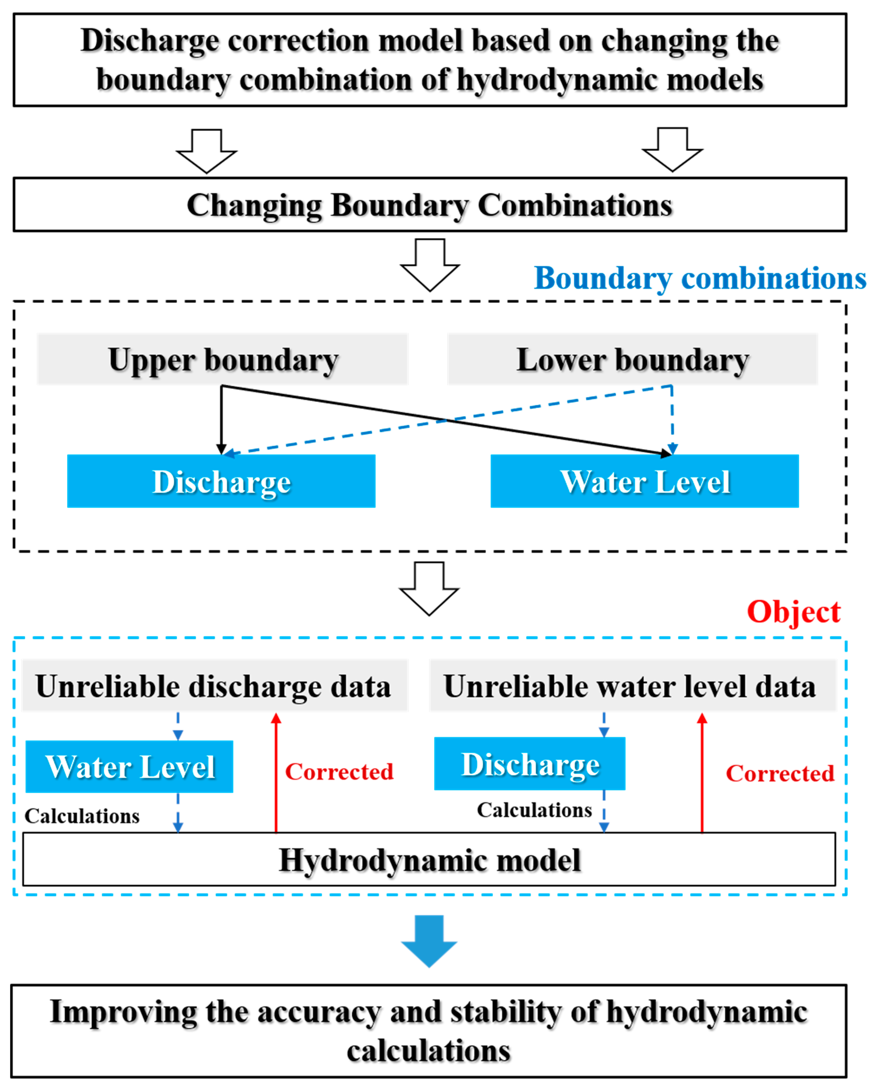
3. Methodology
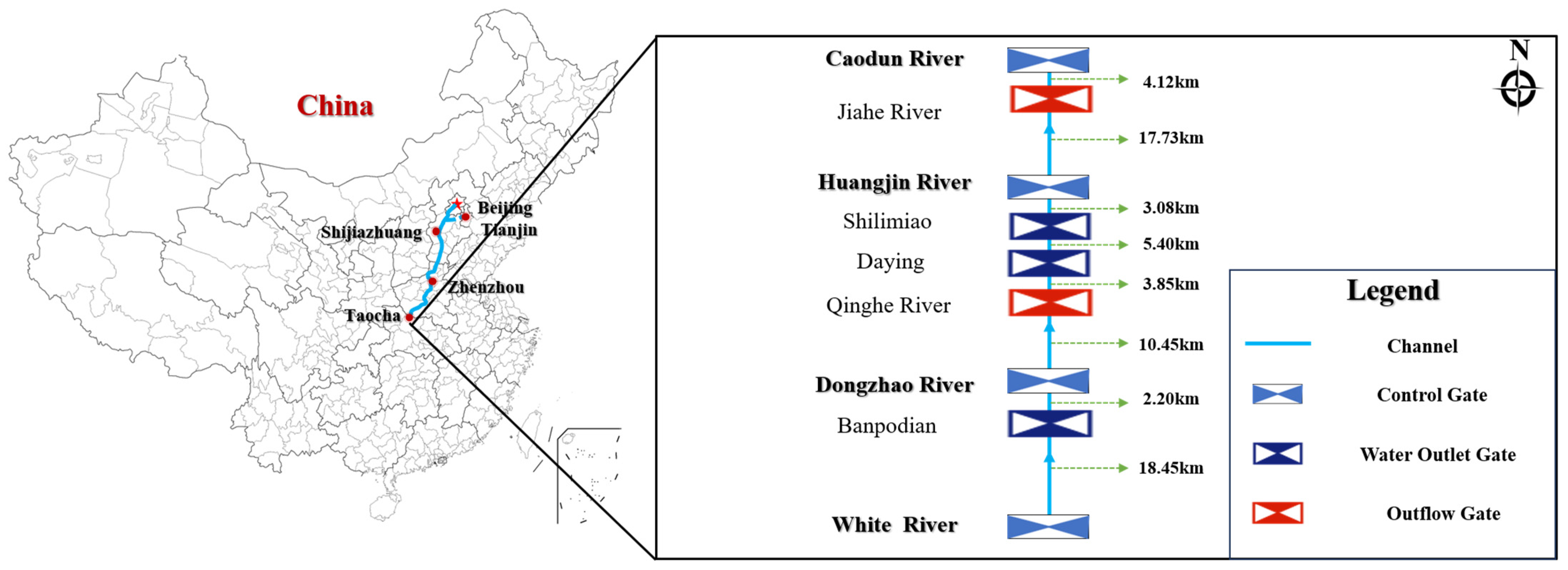
3.1. Study Area
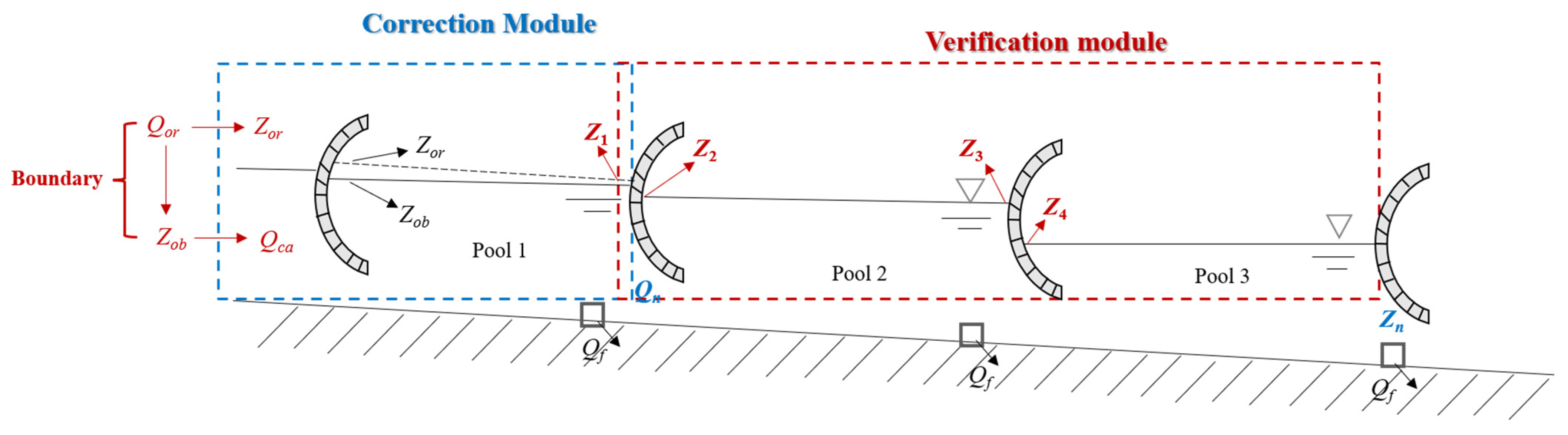
3.2. One-Dimensional Hydrodynamic Model
3.3. Evaluation Indicators
4. Results and Discussion
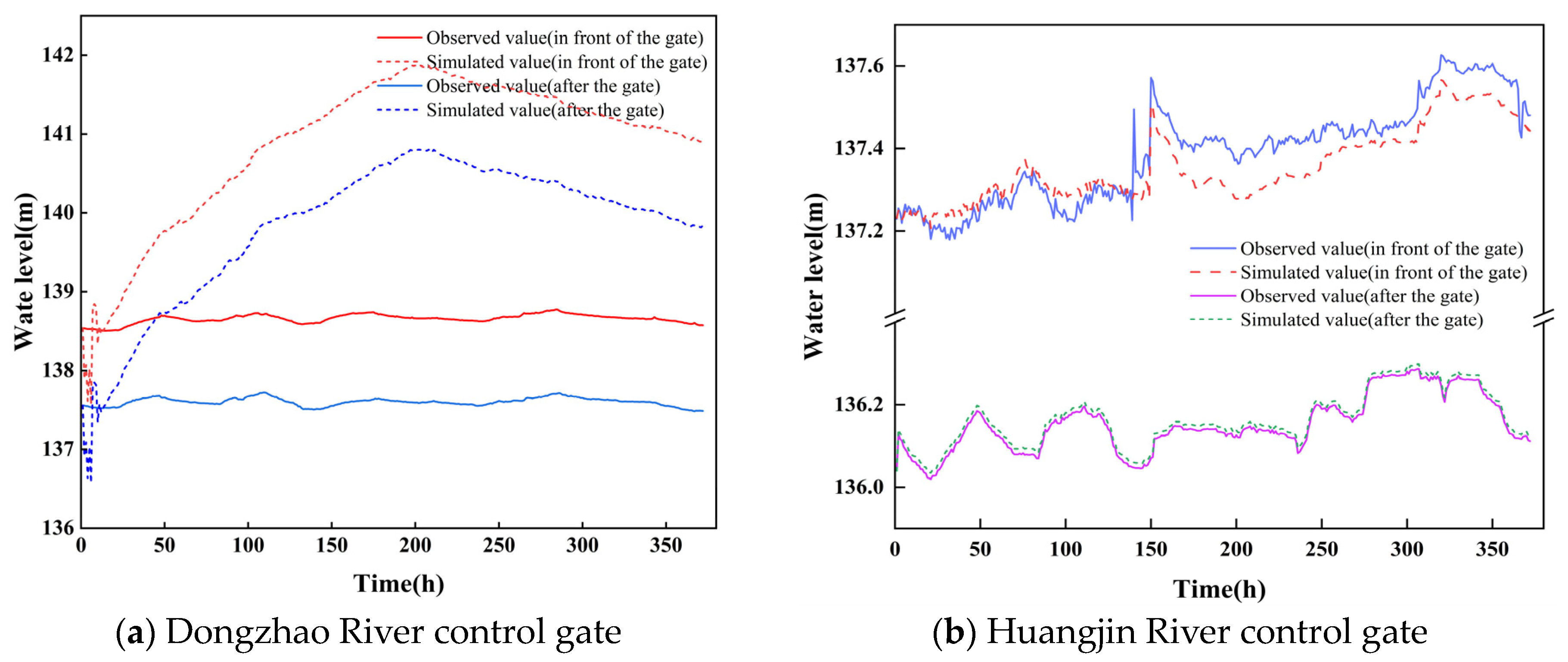
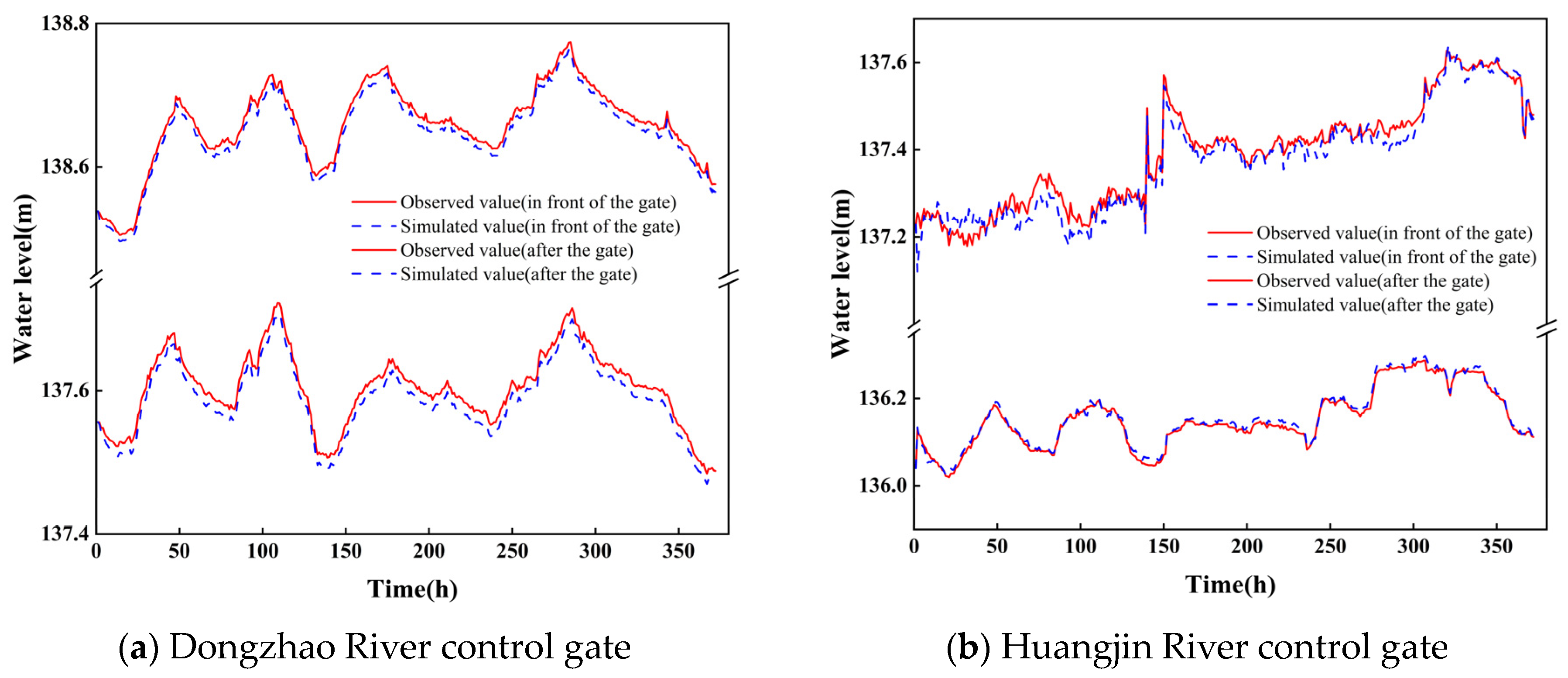
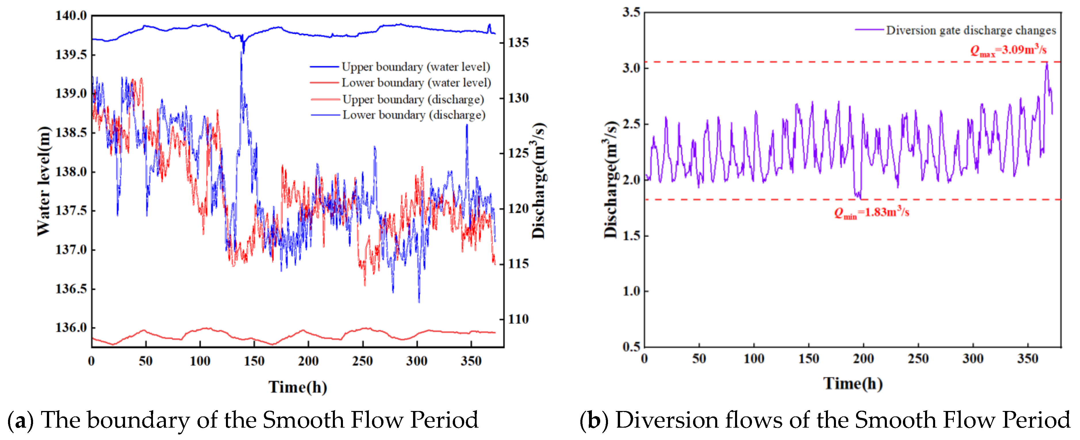
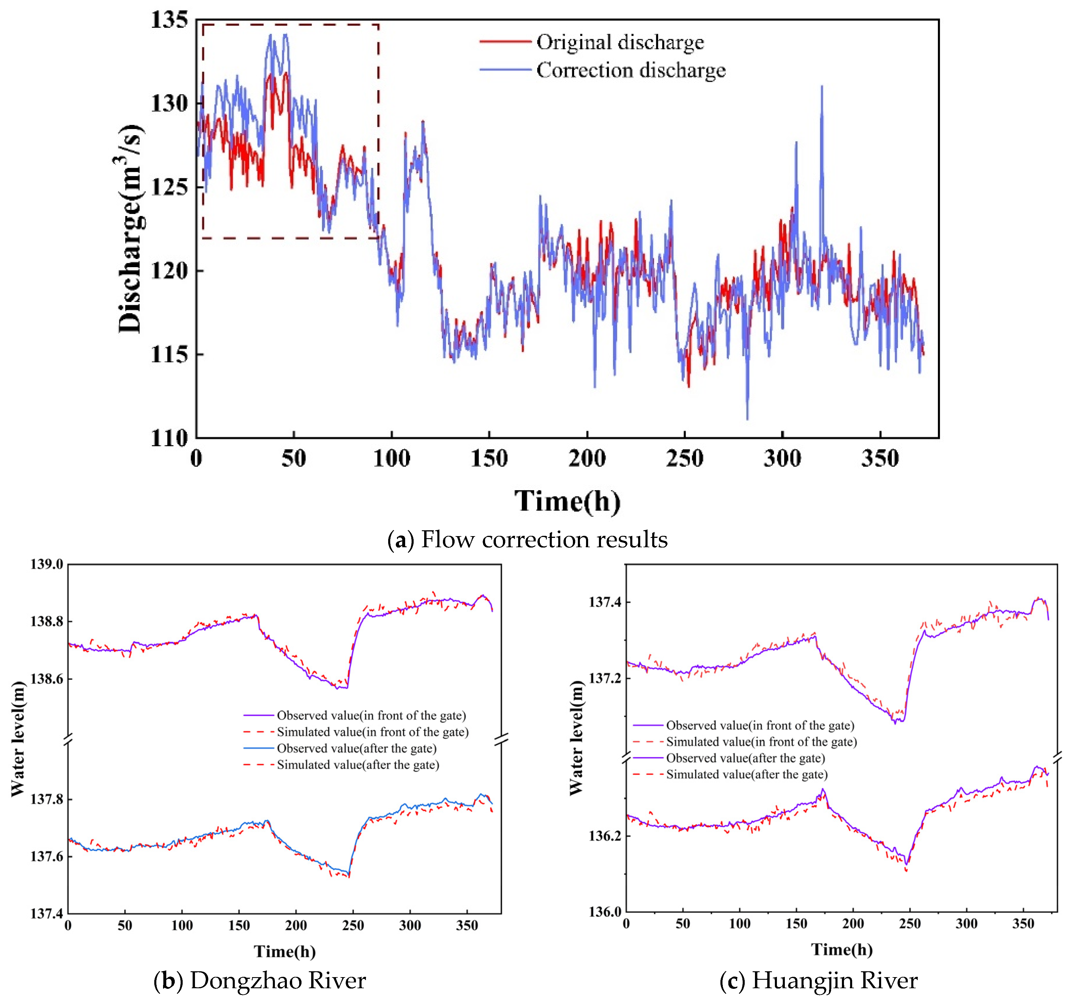
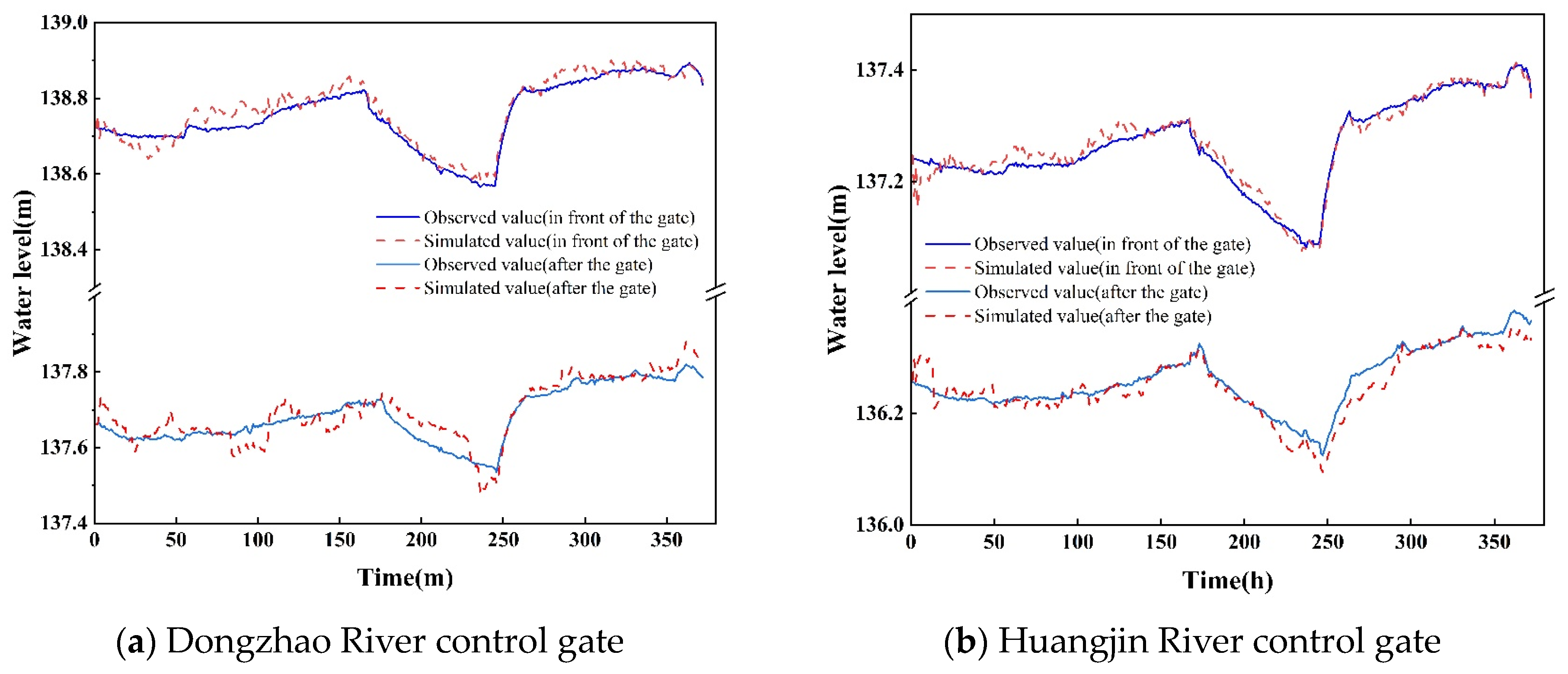
4.1. Flow Adjustment Period Throttle Gate Overflow Correction Results
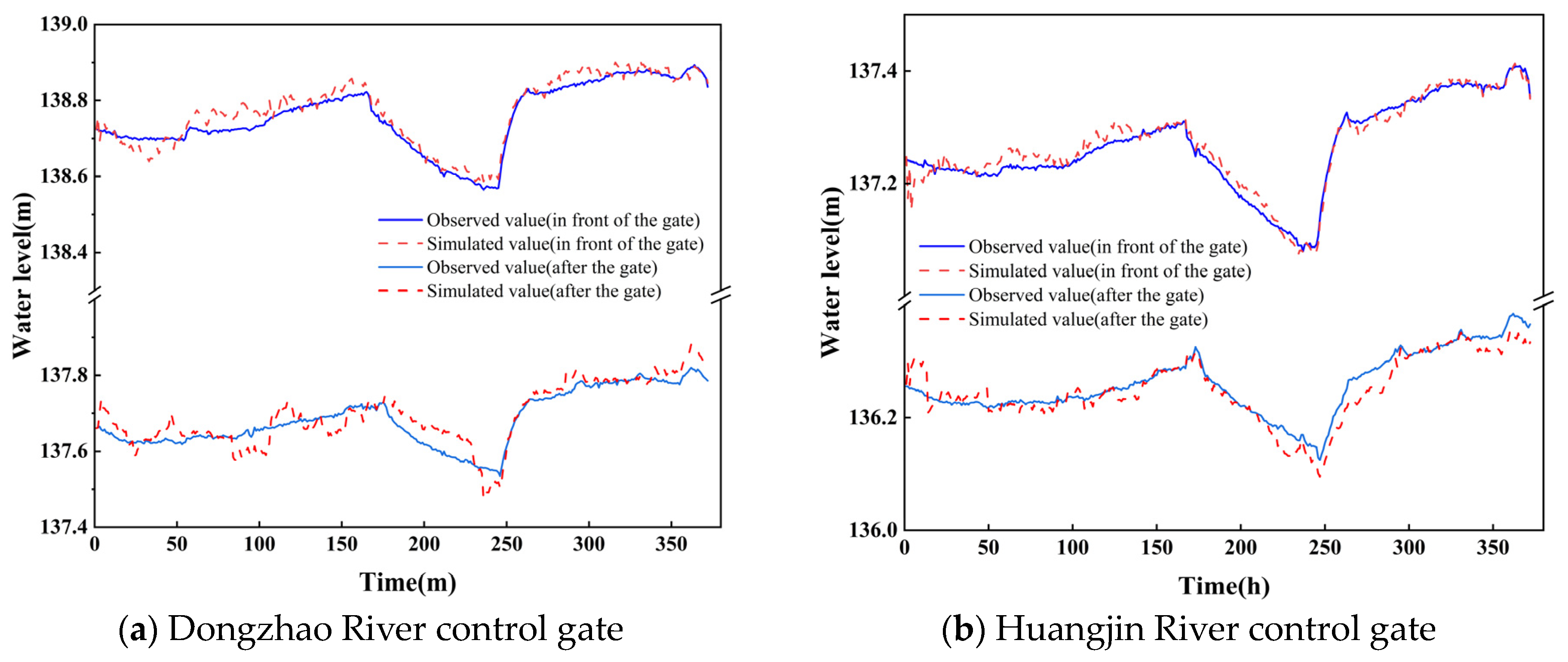
4.2. Corrected Results of Throttle Gate Overflow during the Smooth Flow Period
4.3. Discussion
5. Conclusions
- In the flow adjustment period, using the method proposed in this paper, the hydrodynamic model can be well avoided because of the inaccuracy of the monitoring data, which leads to the inaccuracy of the hydrodynamic model calculation. Comparing the hydrodynamic results of the corrected flow rate and the original flow rate, it can be found that the maximum R2 can be improved by 0.72, the NSE can be improved by 0.84, and the RMSE can be reduced by 1.65 m.
- In the process of flow stabilization, comparing the modified and original hydrodynamic results, it can be found that although the overall hydrodynamic simulation accuracy of the method proposed in this paper is not very significant, it is more accurate in capturing the location of the flow, which may be monitored abnormally, and making corrections to ensure that the local hydrodynamic simulation is better so that the results are more responsive to the water level-flow relationship of the channel. The results are more reflective of the water level-flow relationship of the channel.
Author Contributions
Funding
Data Availability Statement
Conflicts of Interest
References
- Wang, Q.; Zhou, H.; Liang, G.; Xu, H. Optimal Operation of Bidirectional Inter-Basin Water Transfer-Supply System. Water Resour. Manag. 2015, 29, 3037–3054. [Google Scholar] [CrossRef]
- Long, Y.; Xu, G.; Ma, C.; Chen, L. Emergency control system based on the analytical hierarchy process and coordinated development degree model for sudden water pollution accidents in the Middle Route of the South-to-North Water Transfer Project in China. Environ. Sci. Pollut. Res. 2016, 23, 12332–12342. [Google Scholar] [CrossRef] [PubMed]
- Wang, J.B.; Zhao, J.S.; Lei, X.H.; Wang, H.; Wei, J.; Liao, W. Inverse simulation of ungauged branch inflow based on the EnKF. J. Hydraul. Eng. 2019, 50, 11189–11199. (In Chinese) [Google Scholar]
- Elshorbagy, A.; Simonovic, S.P.; Panu, U.S. Estimation of missing streamflow data using principles of chaos theory. J. Hydrol. 2002, 255, 123–133. [Google Scholar] [CrossRef]
- Ge, C.C.; Gao, Y.J.; Miao, X.Y.; Wang, H.B. A hybrid data cleaning framework using Markov logic networks. IEEE Trans. Knowl. Data Eng. 2022, 34, 2048–2062. [Google Scholar] [CrossRef]
- Kong, L.; Song, P.; Ji, Q.; Zhu, S.; Li, J. Water level predictive control in multi-cascade pools with large control interval demand based on constraint methods. J. Hydrol. 2021, 603, 127024. [Google Scholar] [CrossRef]
- Yan, P.R.; Zhang, Z.; Lei, X.H.; Zhu, J.; Wang, H.; Tan, Q.F. A simple method for the control time of a pumping station to ensure a stable water level immediately upstream of the pumping station under a change of the discharge in an open channel. Water 2021, 13, 355. [Google Scholar] [CrossRef]
- Wei, J.Y.; Liao, W.H.; Zhang, Z.; Wang, J.B.; Wang, H. Improved 1-D hydrodynamic simulation of reservoir release based on coarse resolution topography data using ISS-SRC-assisted ensemble Kalman filter. J. Hydrol. 2021, 588, 125036. [Google Scholar] [CrossRef]
- Zhang, X.Q.; Bao, W.M. Dynamic correction of local inflow based on coupling the Xinjiang model and the hydrodynamic model. China Rural. Water Hydropower 2008, 6, 37–41. (In Chinese) [Google Scholar]
- Kong, L.; Li, Y.; Tang, H.; Yuan, S.; Yang, Q.; Ji, Q.; Li, Z.; Chen, R. Predictive control for the operation of cascade pumping stations in water supply canal systems considering energy consumption and costs. Appl. Energy 2023, 341, 121103. [Google Scholar] [CrossRef]
- Li, J.Z.; Guo, X.L.; Gong, T.L.; Wang, J.; Wang, T.; Li, H. A method estimating natural runoff in regions with no or less data. J. Hydraul. Eng. 2018, 49, 1420–1428. (In Chinese) [Google Scholar]
- Lebecherel, L.; Andreassian, V.; Perrin, C. On regionalizing the Turc-Mezentsev water balance formula. Water Resour. Res. 2013, 49, 7508–7517. [Google Scholar] [CrossRef]
- Bozzi, S.; Passoni, G.; Bernardara, P.; Goutal, N.; Arnaud, A. Roughness and Discharge Uncertainty in 1D Water Level Calculations. Environ. Model. Assess. 2015, 20, 343–353. [Google Scholar] [CrossRef]
- Kong, L.; Chen, R.; Tang, H.; Yuan, S.; Yang, Q.; Ji, Q. Ensemble data assimilation for open channel water level forecasting under flow disturbances: A synthetic data study. J. Hydrol. 2023, 625, 130116. [Google Scholar] [CrossRef]
- Xu, M.; Van Overloop, P.J.; Van De Giesen, N.C. On the study of control effectiveness and computational efficiency of reduced Saint-Venant model in model predictive control of open channel flow. Adv. Water Resour. 2011, 34, 282–290. [Google Scholar] [CrossRef]
- Liu, W.; Guan, G.; Tian, X.; Cao, Z.; Chen, X. Exploiting a Real-Time Self-Correcting Digital Twin Model for the Middle Route of the South-to-North Water Diversion Project of China. J. Water Resour. Plan. Manag. 2023, 149, 04023023. [Google Scholar] [CrossRef]
- Zhou, L.; Qiao, Y.; Zhang, Z.; Han, Z.; Lei, X.; Qin, Y.; Wang, H. Development of a novel outlier index for real-time detection of water level outliers for open-channel water transfer projects. J. Hydroinform. 2023, 25, 1072–1083. [Google Scholar] [CrossRef]
- Firat, M.; Turan, M.E. Monthly river flow forecasting by an adaptive neuro-fuzzy inference system. Water Environ. J. 2009, 24, 116–125. [Google Scholar] [CrossRef]
- Yaseen, Z.M.; Naganna, S.R.; Sa’adi, Z.; Samui, P.; Ghorbani, M.A.; Salih, S.Q.; Shahid, S. Hourly River Flow Forecasting: Application of Emotional Neural Network Versus Multiple Machine Learning Paradigms. Water Resour. Manag. 2020, 34, 1075–1091. [Google Scholar] [CrossRef]
- Wang, H.; Wang, J.H. Sustainable utilization of China’s water resources. Bull. Chin. Acad. Sci. 2012, 27, 352–358+331. (In Chinese) [Google Scholar]
- Jiang, Y.Z.; Zhao, H.L.; Dong, Y.J. Key technology research of water resources operation for Middle Route Project of South-to-North Water Diversion Project. S. N. Water Transf. Water Sci. Technol. 2007, 5, 1–5. (In Chinese) [Google Scholar]
- Zhu, J.; Zhang, Z.; Lei, X.; Jing, X.; Wang, H.; Yan, P. Ecological scheduling of the middle route of south-to-north water diversion project based on a reinforcement learning model. J. Hydrol. 2021, 596, 126107. [Google Scholar] [CrossRef]


| Name of the Control Gate | R2 | RMSE | NSE | ||
|---|---|---|---|---|---|
| Dongzhao River | Water level | In front of the gate | 0.23 | 1.73 | 0.13 |
| After the gate | 0.21 | 1.34 | 0.14 | ||
| Huangjin River | Water level | In front of the gate | 0.84 | 0.19 | 0.88 |
| After the gate | 0.95 | 0.05 | 0.96 | ||
| Name of the Control Gate | R2 | RMSE | NSE | ||
|---|---|---|---|---|---|
| Dongzhao River | Water level | In front of the gate | 0.95 | 0.05 | 0.97 |
| After the gate | 0.93 | 0.06 | 0.95 | ||
| Huangjin River | Water level | In front of the gate | 0.91 | 0.09 | 0.90 |
| After the gate | 0.97 | 0.02 | 0.99 | ||
| Name of the Control Gate | R2 | RMSE | NSE | ||
|---|---|---|---|---|---|
| Dongzhao River | Original discharge | In front of the gate | 0.94 | 0.05 | 0.94 |
| After the gate | 0.95 | 0.06 | 0.92 | ||
| Corrected discharge | In front of the gate | 0.95 | 0.04 | 0.94 | |
| After the gate | 0.97 | 0.03 | 0.95 | ||
| Huangjin River | Original discharge | In front of the gate | 0.96 | 0.03 | 0.94 |
| After the gate | 0.97 | 0.02 | 0.95 | ||
| Corrected discharge | In front of the gate | 0.97 | 0.03 | 0.96 | |
| After the gate | 0.97 | 0.03 | 0.95 | ||
| Name of the Control Gate | R2 | RMSE | NSE | ||
|---|---|---|---|---|---|
| Dongzhao River | Original discharge | In front of the gate | 0.94 | 0.05 | 0.94 |
| After the gate | 0.95 | 0.05 | 0.94 | ||
| Neural network | In front of the gate | 0.95 | 0.04 | 0.94 | |
| After the gate | 0.95 | 0.04 | 0.94 | ||
| Huangjin River | Original discharge | In front of the gate | 0.96 | 0.03 | 0.94 |
| After the gate | 0.96 | 0.03 | 0.94 | ||
| Neural network | In front of the gate | 0.97 | 0.03 | 0.96 | |
| After the gate | 0.97 | 0.03 | 0.96 | ||
Disclaimer/Publisher’s Note: The statements, opinions and data contained in all publications are solely those of the individual author(s) and contributor(s) and not of MDPI and/or the editor(s). MDPI and/or the editor(s) disclaim responsibility for any injury to people or property resulting from any ideas, methods, instructions or products referred to in the content. |
© 2024 by the authors. Licensee MDPI, Basel, Switzerland. This article is an open access article distributed under the terms and conditions of the Creative Commons Attribution (CC BY) license (https://creativecommons.org/licenses/by/4.0/).
Share and Cite
Chen, M.; Wei, W.; Zhang, Z.; Xue, L.; Kong, L.; Li, H.; Liu, Y.; Liu, H. A New Open Channel Flow Correction Method Based on Different Boundary Combinations in Hydraulic Modeling. Water 2024, 16, 284. https://doi.org/10.3390/w16020284
Chen M, Wei W, Zhang Z, Xue L, Kong L, Li H, Liu Y, Liu H. A New Open Channel Flow Correction Method Based on Different Boundary Combinations in Hydraulic Modeling. Water. 2024; 16(2):284. https://doi.org/10.3390/w16020284
Chicago/Turabian StyleChen, Mingrui, Wentao Wei, Zhao Zhang, Linan Xue, Lingzhong Kong, Haichen Li, Yuxin Liu, and Hairuo Liu. 2024. "A New Open Channel Flow Correction Method Based on Different Boundary Combinations in Hydraulic Modeling" Water 16, no. 2: 284. https://doi.org/10.3390/w16020284
APA StyleChen, M., Wei, W., Zhang, Z., Xue, L., Kong, L., Li, H., Liu, Y., & Liu, H. (2024). A New Open Channel Flow Correction Method Based on Different Boundary Combinations in Hydraulic Modeling. Water, 16(2), 284. https://doi.org/10.3390/w16020284