Article

Flooding Hazard Vulnerability Assessment Using Remote Sensing Data and Geospatial Techniques: A Case Study from Mekkah Province, Saudi Arabia

Department of Civil Engineering, College of Engineering, King Saud University, P.O. Box 800, Riyadh 11421, Saudi Arabia
*
Author to whom correspondence should be addressed.
Water 2024, 16(19), 2714; https://doi.org/10.3390/w16192714
Submission received: 24 August 2024 / Revised: 13 September 2024 / Accepted: 18 September 2024 / Published: 24 September 2024
(This article belongs to the Special Issue Research on Watershed Ecology, Hydrology and Climate)

Abstract

:
Flash floods are catastrophic phenomena that pose a serious risk to coastal infrastructures, towns, villages, and cities. This study assesses the risk of flash floods in the ungauged Mekkah province region based on specific and effective morphometric and topographic features characterizing the study region. Shuttle Radar Topography Mission (SRTM) data were employed to construct a digital elevation model (DEM) for a detailed analysis, and the geographical information systems software 10.4 (GIS) was utilized to assess the linear, area, and relief aspects of the morphometric parameters. The ArcHydro tool was used to prepare the primary parameters, including the watershed border, flow accumulation, flow direction, flow length, and stream ordering. The study region’s flash flood hazard degrees were assessed using several morphometric characteristics that were measured, computed, and connected. Two different and effective methods were used to independently develop two models of flood vulnerability behaviors. The integrated method analysis revealed that most of the eastern and western parts of the studied province provide high levels of flood vulnerability. Due to it being one of the most helpful topographic indices, the integrated flood vulnerability final map was overlayed with the topographic position index (TPI). The integrated results aided in understanding the link between the general basins’ morphometric characteristics and their topographical features for mapping the different flood susceptibility locations over the entire studied province. Thus, this can be applied to investigate a surface-specific reduction plan against the impacts of flood hazards in the studied landscape.

1. Introduction

Periodically, our world has suffered from great destruction that has affected both properties and lives. Flooding hazards have arisen as one of the most common major events among sudden natural hazards. Extreme rainfall hazards generally result from flooding due to rapid-onset, high-intensity rainfall in a short duration, causing high- and sudden-velocity flows [1,2,3,4,5]. Since the water level reaches its peak very fast, local response groups face difficulties predicting the situation and have very little time to offer warning strategies [5,6,7]. Although there have been great efforts made by governments and societies to manage this critical issue, they struggle to report suitable models for prediction and management [1,8,9]. Flooding hazards are now suggested to be the most frequent hazards due to climatic changes and other environmental factors. This is because climatic changes are widely known to force most flood events to occur [10,11,12]. Thus, it is necessary to gather, process, and analyze high-resolution hydrological and geomorphological data and to create comprehensive models that can aid in preparing a strategy that effectively mitigates flood hazards [8,13]. Due to the acceleration in flooding hazard damage and the loss of lives, great attention has been paid to this topic. Studying recent flooding events can provide valuable insights into how different causes, activities, and behaviors influence flooding in different locations. Recent studies investigated and discussed rainfall distribution patterns, runoff hydrographs, dam break analyses, flood hazard simulations, stream characterizations, and moisture conditions in various locations in Saudi Arabia, including the Medina area [14], Mekkah region [15], Jeddah City [16,17], southwestern parts of Saudi Arabia [18], and some basins in the western part of Saudi Arabia [19].
Various methods have been used to assess flooding issues effectively. Geomorphological and geological conditions were investigated and modeled to assess flood hazards for some urban locations in Greece [20]. Morpho-hydrological analysis techniques were used to preliminarily map a flash flood in northwestern Saudi Arabia [21]. Groundwater characteristics, rainfall intensity, and flooding effects were studied to investigate their influence on the socio-economic situation in Pakistan [22,23]. Additionally, advanced techniques including remote sensing and geographic information systems were utilized to calculate the total water quantity in the Peshawar basin in Pakistan [24]. Flash flood hazard properties were investigated and evaluated along the Red Sea coast in Egypt between the cities of El-Qussier and Mersa-Alam [25]. The geomorphic characteristics of landscapes are changing due to the impact of rainfall from storms and flooding hazards. Several analog and numerical studies were focused on flood hazards, providing various answers to many vague questions [26,27]. Thus, gathering, arranging, and analyzing reliable and accurate information may help in building a significant model of flood hazards. These output models should help decision-makers prepare effective plans to mitigate the negative effects of such natural hazards. Modern techniques and analyses have proven to have the ability to extract valuable information and reliable maps to provide significant models of flooding hazards [8,25,28]. Morphometric parameters such as the stream order, stream length, stream number, stream frequency, drainage density, form factor, texture ratio, basin relief, basin elevation ratio, infiltration number, and ruggedness number are very powerful keys in studying flood hazards effectively.
Mekkah province is among the thirteen provinces in the Kingdom of Saudi Arabia. By area, it is the third-largest province in the Saudi Kingdom, with an area of 153.128 km2 (Figure 1). It occupies a large area within the southwestern part of Saudi Arabia. It is located at 18°33′ N to 23°40′ N and along the eastern Red Sea coast to 43°49′ E. This studied province covers several cities, including Mekkah, Rabigh, Thuwal, Jeddah, Khurmah, Taif, Turban, Al Khurma, Rayan, Al-Lith, and Al-Qunfudhah (Figure 1). Additionally, Mekkah province is a part of the Hejaz region in western Saudi Arabia that stretches from Jordan in the north to the Asir region in the south along the Arabian Peninsula’s rugged Red Sea coast (Figure 1). Mekkah province always receives significant attention from the Saudi government, which is forcing them to undertake extreme efforts to develop and protect against any natural hazards. Therefore, most environmental studies are supported and motivated by the Saudi government. This work aims to (a) provide a significant flood hazard assessment model using the quantitative analysis of several valuable and applicable morphometric analyses; (b) test the extracted anomalous data in order to understand the flood hazard causes and behaviors; (c) expand our understanding of the morphological signatures recorded by the flash flood hazard impact; and finally, (d) create a final and comprehensive model to help decision-makers implement suitable plans for developing such a very important region.

2. Study Province Description

Mekka province is one of the most significant regions in Saudi Arabia due to its religious and historical significance. This important region is characterized by high population density and economic importance as the kingdom of Saudi Arabia’s commercial and logistic center. It is located in the middle part of the western region of Saudi Arabia, connecting the Red Sea with the land. The administrative borders of Mekkah province are delineated by Al-Madinah province to the north, Riyadh province to the east, Asir province to the south, and the Red Sea major rift to the west (Figure 1).
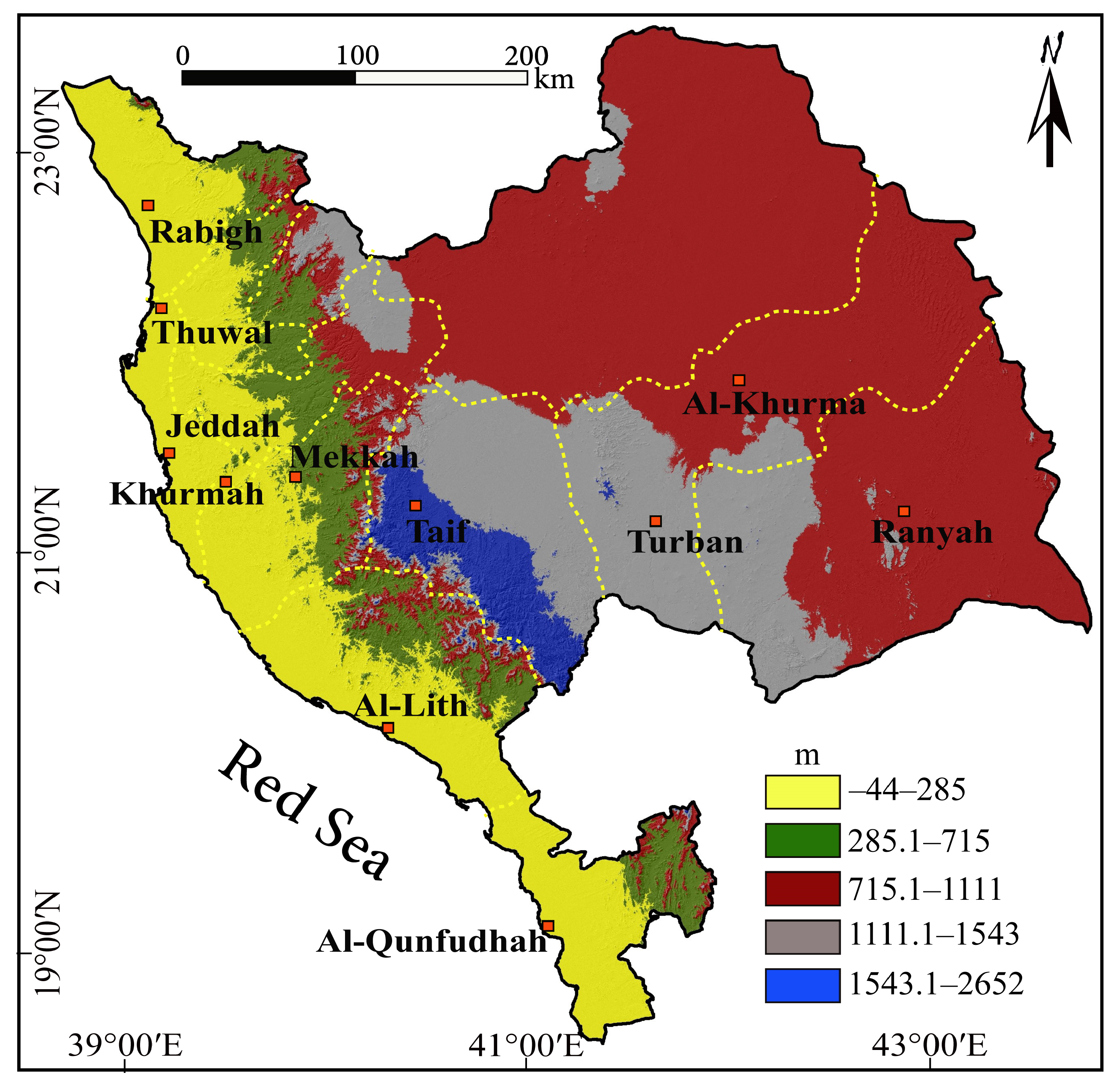
The lithological or geological characteristics of different basins are very important keys that aid in expanding our knowledge about the impact of the morphometric signatures on the morpho-hydrological conditions of drainage basins. The effect of these morphometrics can be seen in the drainage pattern and hydrographic basin geometry, which dictates the best places for water harvesting as well as the severity of flash floods [29]. Generally, geological times of Mekkah province range between Precambrian and Quaternary [29]. Due to the geological description of Saudi Arabia [30], Mekkah province covers a crucial region of the Arabian Shield, which forms the mountain range of the Red Sea coastal plain. The geology framework of Mekkah province is represented by several different rock units. Most of Mekkah province is occupied by Quaternary sand, silt, gravel, conglomerate, evaporites, and coral limestone. They cover more than half of Mekkah province’s geological map (Figure 2). The second major rock unit on the map is basalt igneous activity. It occupies significant portions of the northern, eastern, and southern parts of the geological map (Figure 2). Figure 2 illustrates the rest of the geological units and their distributions. As illustrated in Figure 3, Mekkah province’s topographical framework can be classified into five different reliefs, which range from −40 to 2652 m. The terrain heights are concentrated along the middle part of the study province as a narrow zone along the NW-SE direction with an elevation range between 1543.1 and 2652 m amsl. This zone represents the mountain range and upstream parts of the hydrographic framework of the study province. The low relief zone elevation scale ranges from −44 to 285 m. The lowest terrain areas run along the coastal plain of the Red Sea, providing elevations between −40 and 285 amsl. These very low areas are characterized by a mild slope, providing conditions suitable for easy flooding.
Mekkah province experiences hot and dry climate conditions in summers and warm and dry conditions in winters, similar to typical coastal desert regions [29]. During the summer months, the highest temperature reaches 44 °C, while the lowest temperatures are below 30 °C. Figure 4 presents the mean annual rainfall recorded in Mekkah province. Data illustrated in this figure are for time between 1970 and 2010 (https://www.mewa.gov.sa/en/Pages/default.aspx, accessed on 12 May 2024). During this period, the maximum and minimum annual rainfall amounts recorded were 228 and 10 mm, respectively. Additionally, Mekkah province received 85.4 mm as an average annual rainfall with a standard deviation of 62.4 mm. The analysis of the previous data showed an abrupt change in the annual rainfall amount marked by the year 1988, where the rainfall record was 125 mm. The period between 1989 and 2010 recorded a mean annual value of 50 mm. This abrupt change in the rainfall amount of Mekkah province could be due to rising air temperatures, expanding desertification, and an increase in the frequency of extreme weather events, including heat waves, droughts, floods, and storms, all of which are signs of climate change. Additionally, not every region is equally impacted by climate change; some are more severely affected than others [29]. The average annual rainfall records between 2011 and 2020 were mapped and are illustrated in Figure 5. The highest amount of rainfall is concentrated in the middle of Mekkah province, while the lowest amounts were recorded along the Red Sea coast (https://crudata.uea.ac.uk/cru/data/hrg/, accessed on 20 May 2024). The majority of Mekkah province’s rainy season falls between November and April, according to meteorological records [15].

3. Materials and Methods

The analysis of this work was run depending on different vector and raster data. A 30 m spatial resolution 1-arc second digital elevation model (DEM) Shuttle Radar Topography Mission (SRTM) was obtained from the USGS geological survey website (https://earthexplorer.usgs.gov/, were accessed on 1 July 2024) to investigate Mekkah province. Additionally, topographical maps were gathered and prepared to aid in extracting the results of this work. Spatial analysis tools in the Arc-GIS 10.4 software package and prepared data were used for morphometric analysis over the entire area of Mekkah province. The four topographical sheets that were obtained were first turned into TIFF files and then each georeferenced separately using the ArcGIS 10.4 software. The legends on the topographical sheets obtained in this way could lead to matching mistakes during digitization. The mosaic tool in ArcGIS software was then used to clip and combine the georeferenced toposheets into a single composite topographical sheet that covered the whole study area. Accordingly, the combined toposheet was digitalized to produce the basin’s stream network. As previously mentioned, the toposheet has many missing stream linkages that were later filled in using network analysis of the DEM. The methodology applied in the current work went through several processing steps (Figure 6). The pre-processing division was tasked with preparing and fixing the raw data of the study province. Several studies outlined how precise basin delineation is necessary for flood hazard assessment and management approaches, as this will lead to the correct determination of stream flow routes and their contributing areas [25,31,32,33,34]. Several hydrology preprocessing tools, such as fill sinks, flow direction, flow accumulation, snap-pour, stream order, stream feature, and watershed were run to manipulate the combined DEM and topographical data. In the current study, stream network generation from DEM revealed a significant geographical deviation from ground truth, particularly close to the outlets of the basins. This could be explained by the relatively minor relief fluctuation in the flood plain area. It takes a lot of time and work to perform morphometric analysis on the digital drainage network. Even with the aid of sophisticated computing tools like ArcGIS, processes like stream ordering for each segment, its naming, merging, and dividing stream segments at suitable locations take a long time. The original DEM is reconditioned and burnt-in using the digital stream networks from the toposheets. The sink fill algorithm and interpolation techniques were used to patch missing data and preprocess the DEM to minimize inaccuracies. Next, using the Arc-GIS “Hydrology” tool, the restored DEM was utilized to draw the boundaries of the drainage network, stream order network, and watershed. The flow directions in the research region were ascertained by utilizing the D8 (eight directions) flow direction method. Water can move from one raster cell to its eight adjacent cells in accordance with this procedure. The algorithm determines which adjacent cell has the steepest downslope and, based on the flow directions, assigns an integer code between 1 and 255. Identifying the “cell threshold” value, or the number of raster cells needed to begin a stream grid, is one of the most crucial stages in defining a drainage network. Because the threshold value and drainage density are negatively correlated, a higher threshold value will translate into fewer streams. A value of 75 (number of cells) was determined to be suitable for the research area after thorough visual comparisons between the drainage network from the topographical sheet and streams created with different thresholds. Note that for the topographical sheet at different scales, the ideal threshold value is 75 cells; this number will change for topographical sheets at other sizes. In the current work, Mekkah province was divided into 80 basins with greater than the fourth stream orders (Figure 7). The extracted values of the basins’ geometry features, including basin total area, perimeter, length, and average elevation, demonstrated that the largest total area and perimeter were calculated for basin 80 in the eastern part of the study province as 39,718.41 km2 and 1565.12 km, respectively (Table S1 in Supplementary Data). On the other hand, basin 10 in the west gives the smallest values for the total area and perimeter as 55.93 km2 and 67.94 km, respectively (Table S1 in Supplementary Data). The geometrical analysis of the study province also showed that the longest and shortest basins were observed as 177.84 km and 12.67 km for basins 61 and 71, respectively (Table S1 in Supplementary Data). Table S1 in the Supplementary Data provides all information about total area, perimeter, basin length and width, and height for all 80 basins. Despite the updated GIS tools’ ability to manipulate data and speed up computation, morphometric studies continue to provide challenges for academics. The linear, areal, and relief characteristics of Mekkah province and its 80 basins have been ascertained using an automated morphometric toolkit for ArcGIS written in the Python language, created by the author in Ref. [35]. The minimal amount of data needed for this toolbox is a projected coordinate system digital elevation model (DEM), a stream order shapefile, and a watershed border. In contrast to DEM obtained from optical ASTER, the SRTM DEM is derived using the radar system, which is less impacted by weather conditions. Nevertheless, errors can occur in any DEM, regardless of the data source and processing method. Topographic representations known as digital elevation models (DEMs) include intrinsic inaccuracies that add up to uncertainty. The level of uncertainty related to applying the morphometric indices on the assessment of the flooding hazards was reduced by the DEM resolution. Unlike prior studies, we do not place a level of uncertainty on our geomorphic indices [36,37].
Morphometric indices, which are the core of this study, are tabulated in Table 1. In the current study, the processing work steps were carried out due to two major techniques, including basin classes and ranked techniques. Every single technique or method was applied broadly to understand variations in flooding hazard characteristics [21,31,33]. Therefore, every method demonstrates the ability to assess the flooding hazards by itself. In the current study, we applied an integration between the two quantitative analysis methods to model their results and assess the compatibility level between them. Additionally, the study also aimed to combine the final map produced from these two merged methods with an effective topographic index (Topographic Position Index, TPI) (Table 2). This final model aimed to define the flooding hazard susceptibility levels of the study province through classifying it into different levels of flooding hazards (Figure 7).

3.1. Basin Class Method

This method is applied to examining and calculating several effective morphometric indices (Table 1). It aims to understand the relative variation between these indices and assign them to different relative hazard levels. To ensure consistency, the morphometric indices of each basin are categorized into low, moderate, and high flood susceptibilities using a 1–3 scale. This technique works by categorizing values that are very close to each other in digits; thus, three classes are produced. A new averaged value is given for each index of all the basins concerning the nature of the range within a single morphometric index (− or + relation about flash flood level scale). The flood vulnerability levels for each basin are then assigned in a final flood susceptibility map by extracting a cumulative value digit.

3.2. Ranked Method

One of the most crucial methods for mapping the possibility of flooding hazards is the ranking system that is known as a linear method. This method was applied and developed by authors in Refs. [8,38] using an effective strategy for assessing the flood hazard levels of landscapes. The core of this method is to scale the flooding hazards into six different levels using the following equations. For each basin in the research province, the levels are adjusted to match the morphometric indices that were obtained [8]. In this method, the flooding hazard levels are classified into 6 classes as extreme, very high, high, moderate, low, and very low flood hazard classes, respectively. The ranked technique applies using a geometric relation developed by the author in Ref. [39]. To establish a directly proportional and an inversely proportional relationship, respectively, the following geometric relations are created for the indices.
Flooding hazard level = [4 × (X − Xmin.)/(Xmax. − Xmin.)] + 1
Flooding hazard level = [4 × (X − Xmax.)/(Xmin. − Xmax.)] + 1
where X represents the morphometric index values for each individual basin, and the parameters Xmax. and Xmin. provide the highest and lowest values of the calculated index using the suggested basins. The flash flood evaluation scale was adjusted and reset into three risk categories, giving number 1 (low level), number 2 (moderate level), and number 3 (high level), to provide a consistent approach for the methodologies used in this study. As a result, the following modified geometric proportional relationship is used to apply the computations of this approach as direct and inverse, respectively.
Flooding hazard level = [2 × (X − Xmin.)/(Xmax. − Xmin.)] + 1
Flooding hazard level = [2 × (X − Xmax.)/(Xmin. − Xmax.)] + 1

3.3. Integrated Approach

An integrated approach between two effective flooding hazard assessments is applied in this study for the first time. In the current study, we aim to increase the degree of confirmation in understanding flooding hazard signals and features. The results of every method were classified into three classes of flooding hazard susceptibility; therefore, in the integrated methodology, we combine the classes for every single basin and assign the average to map the final flooding hazard classes for the study province.

3.4. Morphmetric Indices

Investigating the basic flood vulnerability indicators, in addition to understanding the nature and origin of the drainage basins, is the core of the morphometric analysis model [25,40]. Several studies have examined how drainage basin morphometry plays a significant role in the frequency and intensity of flood occurrences due to the significant influence of morphometric behaviors on the various hydrological impacts of the study province [8,40].
Table 1. Morphometric indices applied in this study.
Morphometric IndicesIndices FormulaReferences
Area (A) It defines the total area from drainage divide to basin boundary[41,42]
Perimeter (P)It defines the horizontal projection of its water divide[21]
Basin length (Lb)It measures the maximum basin length parallel to the main basin river[25,43]
Stream number (Ns)Ns = N1 + N2 + N3 + ………Nn[43]
Stream length (Ls)Ls = L1 + L2 + L3 + ………Ln[28]
Stream order (Os)Hierarchical rank equation[26]
Bifurcation ratio (Rb)Rb = Ns/Ns + 1, where Ns is the streaming number value of any order and Ns + 1 is the streaming number value for the next highest order[42]
Stream frequency (Fs)Fs = Ns/A[44]
Form factor (F)F = A/Lb2[40]
Texture ratio (Rt)Rt = Ns/P[45]
Drainage density (Dd)Dd = Ld/A[43]
Infiltration number (If)If = Fs/Dd[46]
Basin relief (Br)Br = Hmax. − Hmin., where Hmax. is the highest elevation point in the basin and Hmin. is the lowest one.[42]
Ruggedness number (Nr)Nr = Dd × (Br/1000)[47]
Elevation relief ratio (Rr)Rr = Br/Lb[43]
Table 2. Topographic index applied in this study.
Topographic IndexIndex FormulaReferences
Topographic position index (TPI) T P I = M 0 n = 0 n ( M n n ) , where M0 is elevation of the model point, Mn is the elevation of the grid, and n is the total number of surrounding points applied in these topographic processes. [48]

3.5. Validation Analysis of Morphmetric Indices

Generally, the morphometric parameter analysis sheds light on how the drainage basins’ hydrological systems react to intense rainfall events. Understanding the drainage basins’ potential for flash flooding and avoiding the damage the hazard may cause is made easier with the help of this knowledge. This knowledge is essential for preventing the hazard’s devastation and for comprehending the drainage basins’ potential for flash flooding. This effective analysis has been applied to simulate the relative flooding susceptibility of basins of variable sizes in each study landscape. Several studies have demonstrated a strong correlation between basin morphometry and basin physiogeographic and hydrological processes, which allows one to deduce from quantitative morphometric analysis the main hydrological behavior of a basin, including flooding, soil erosion, topography, groundwater recharge, and geologic and lithologic formation [22,28,31,32,49,50]. Therefore, this small discussion implies that the analysis of the morphometric parameters is valid, providing sufficient hydrological and geomorphological information that can effectively help in assessing the different flooding hazards in different locations.

4. Results and Discussion

This section is responsible for presenting the results of all processing that has been carried out in this study, in addition to a comprehensive discussion explaining and illustrating the different strategies for flood hazard assessment in the Mekkah province region.

4.1. Morphmetric Indices

In the current study, several effective morphometric indices were examined, calculated, and analyzed. The following subtitles provide an analysis and discussion of the computed findings of the quantitative analysis of the morphometric indices, average calculated values, topographic position analysis, and flood vulnerability levels.

4.1.1. Stream Number Index (Ns)

Generally, drainage basins with a high number of drainage streams experience high runoff conditions and high peak flows of intense rainfall [43,51,52]. Stream number index results present the densest drainage network for the largest basin (Basin 73), while the least dense network is assigned for basin 8, with just one stream segment, supplying the conditions with the lowest runoff capability (Table S2 in the Supplementary Data, Figure 8).

4.1.2. Stream Order Index (Os)

The stream order index acts as one of the most significant hydro-geomorphological indices for assigning and examining the extent of basin water channels. It is employed to display the drainage streams and rivers in a ranking order [8,40]. In the current work, 80b basins of Mekkah province present six different orders, from order I to order VI. Table S2 in Supplementary Data shows the distribution of the six different orders over the study basins. Only one basin (basin 73) provides the highest orders, while basin 8 presents just order 1. Order 5 is displayed in basins 26, 40, 46, 53, 60, and 72, in addition to basin 73. Additionally, order 2 is recorded in all basins except basin 8. For more information about the distribution of the rest of the orders, see Table S2 in Supplementary Data. Significant stream orders, as determined by the investigated relief features, typically indicate the presence of large streams and rivers in the basins that are fed by a variety of small rivers and streams, offering significant potential for flow velocities and water discharge.

4.1.3. Stream Length Index (Ls)

It is known that the stream length index is a dimensional indicator that shows the typical size of the water network and how it affects catchment surfaces [8,53]. Computation involves dividing the overall length of streams and rivers in a specified sequence by the total number of segment lengths in the sequence. All basins together have a total stream length of 10,462.75 km. In the current study, the shortest stream length was computed for basin 8 as 2.90 km, while the longest stream length was assigned to basin 73 as 4379.04 km. Significantly, the stream length index is one of the key indicators used to gauge surface runoff conditions. Long Lu is a sign of high runoff and minimal infiltration [40]. The results show that the stream number index, which has its highest and lowest values recorded in basins 73 and 8, respectively, is the key to consistency with the results (Table 3, Figure 8).

4.1.4. Bifurcation Ratio Index (Rb)

Bifurcation ratio index is one of the most useful morphometrics for determining the degree of basin drainage ramification [21,54]. This index, which measures the ratio of rivers and streams of a given order (Nu) to all rivers and streams of the next highest order (Nu + 1), is expressed as a dimensionless index. In relation to this investigation, basins 6, 20, 23, and 78 have greater bifurcation ratio values than the other basins, at 8.5, 9, 8, and 8, respectively, Alternatively, the lowest values of this index are observed for basins 4 and 10 as 2 (Table 3 Figure 8). According to the author’s discussion in Refs. [25,53], the bifurcation ratio often yields the highest values over drainage basins that are dissected and hilly and the lowest values over basins that are rolling or flat. As a result, both the northeastern and southern regions of the research area have signals of strong runoff conditions, and these signals offer the possibility of minimal lag times for producing floods during periods of intense rainfall.

4.1.5. Stream Frequency Index (Fs)

The overall calculated stream frequency index value for all study basins in this work is 33.754. The northern and northwestern basins of the study province, including basins 53, 54, 57, 63, and 64, have the greatest values of the Fs index. The lowest value obtained from this analysis was for basin 8 as 0.091 (Table 3, Figure 8). The Fs index, which is frequently employed in flooding hazard studies, shows that high values typically suggest a high volume of runoff transmission, which is a function of high-relief features, dispersed vegetation cover, and impermeable soil and rock surfaces [28,42,55].

4.1.6. Form Factor (F)

The form factor can be represented as a ratio between the basin’s area and basin length squared. [56]. According to the analysis findings of this study, the eastern part of the study terrain, which covers basins 72 and 73, has the greatest values of this index, at 1.609 and 1.306, respectively. The lowest value of the form factor index was recorded as 0.126 for basin 4, which is in the southern part of the study province (Table 3, Figure 8). Based on the analysis of this index, authors in Refs. [53,56] proposed that low F values represent low discharge volumes, while high values imply high volumes of discharge in short-duration occurrences.

4.1.7. Texture Ratio Index (Rt)

In morpho-hydrological studies, climate, slope, rainfall, vegetation cover, relief, rock, and soil types all affect the texture ratio (Rt) index [8,53,57]. In terms of this index, hard rock reliefs (consolidated formations) typically generate coarse texture, whereas soft formations covered in vegetation and connected to very low topographic relief provide fine texture [57]. In the current study, the Rt index was divided into four different texture classes as fine, intermediate, and coarse textures. The values of the Rt index range from 0.033 (basin 47) to 89.57 (basin 14). According to the analysis of this factor, three basins have conditions of coarse textures, while thirteen basins are intermediate in terms of texture characteristics. On the other hand, 64 basins are recorded as fine-textured basins. These findings state that nearly three-quarters of the study basins have fine textural conditions and indicate a weak peak discharge generation response (Table 3, Figure 8).

4.1.8. Drainage Density Index (Dd)

Drainage density index was first identified and utilized by the author in Ref. [40]. He investigated and applied this index to define the different characteristics of a basin. The Dd index was also defined by the authors in Refs. [58,59] as the ratio of the overall length of streams to the entire area of a basin. The drainage density index was additionally defined by authors in Ref. [53] as the total length of all studied orders divided by the basin area under investigation. In the current study, basin 57 at the northern part of the study province gives the highest Dd density value as 171.31, while the lowest value of this index was recorded for basin 8 as 11.32 (Table 3). Hence, it seems that basin 57 is likely generating the most runoff.

4.1.9. Infiltration Number Index (If)

The infiltration number (If) index has been widely used in recent morpho-hydrological research for better understanding the infiltration characteristics of various water bodies [45,53]. In the present study, just one basin provides a high value of infiltration number (basin 30), while five basins show the lowest values of this index (basins 4, 10, 18, 47, and 56). Accordingly, 74 basins with moderate infiltration number index values lead the authors to consider this study province as a region with suitable conditions for a moderate rate of infiltration characteristics and amount of runoff [50]. Thus, we can neglect the relatively minimal and maximal infiltration characteristics in the study province.

4.1.10. Basin Relief Index (Br)

Understanding the studied basins’ overall river denudation, runoff volume, and landform changes provides a relatively significant model with the use of basin relief (Br) index. The observed values derived from this index indicate that basins 5, 6, 19, 26, 32, 35, 39, and 40 have the greatest values of this index, with respective values of 2690, 2218, 2636, 2669, 2613, 2608, 2614, and 2332 (Table 3, Figure 8). When assessing the probability levels of flooding events, the values taken from this index are highly helpful and efficient. High levels often imply a high degree of flood probability signals, while low values show little chance of any flooding hazard.

4.1.11. Ruggedness Number Index (Nr)

The degree of slope length and steepness, defining the extent of the instability in the terrain, is described by the roughness number (Rn) index [43,60,61]. The Nr index values for the current work range from 2.66 as the lowest value for basin 65 to 228.42 as the highest value for basin 5 (Table 3). Basins with high Nr values typically have long, steep slopes, high levels of erosion, high rapid peak flow signals, and flash flood possibilities [8,28]. For basins 5, 19, 26, 32, 35, 39, and 73 the greater roughness values were recorded as 2.28, 2.02, 1.98, 1.72, 1.73, 1.74, and 2.03, respectively (Table 3, Figure 8 for basin positions). Thus, basins 5, 19, 26, 32, 35, 39, and 73 have a rugged relief surface and they are strongly susceptible to the action of soil erosion. According to Ref. [53], topography and landscapes were divided into three categories based on Rn: flat topography (Nr<1), undulating topography (Nr between 1 and 2), and badland topography (Nr > 2).

4.1.12. Elevation Relief Ratio Index (Rr)

The elevation relief ratio index is one of the most common relief factors that present the basin topographical characteristics [53]. In the current study, values of Rr range from 3.75 (lowest) for basin 74 to 84.75 (highest) for basin 5 (Table 3, Figure 8). Regardless of variations in topography scale, the relief ratio index aids in comprehending the comparison of relative relief in catchments [21]. Higher Rr values then correspond to lower lag time values, unexpected peak discharge, and a higher likelihood of flood events [21,28].

4.2. Flooding Hazard Due to Watershed Level Method

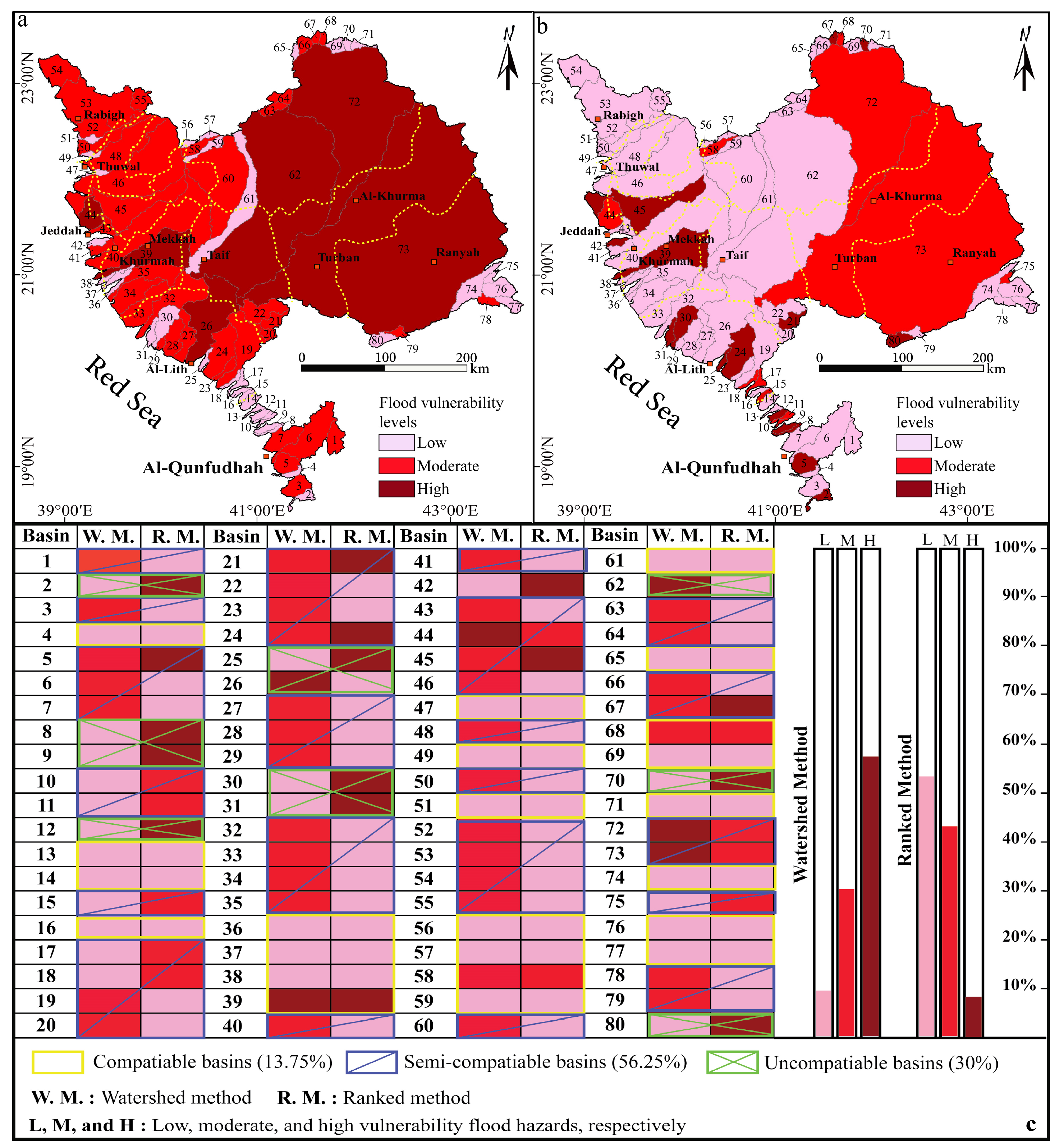
Although various flood hazards have been evaluated using the primitive watershed level method in various environmental localities, it was specifically used to look at the flash warning signals in the province we investigated. This analysis concluded that, in comparison to the other basins, basins 26, 39, 44, 62, 72, and 73 demonstrate the highest conditions of discharge volume, and they are more vulnerable to severe flash floods due to the various cumulative values computed from the applied indices. This group of basins constitutes about 77,673.46 km2 (58.75%), with 3224.36 km2, 2357.05 km2, 747.47 km2, 17,501.69 km2, 14,124.18 km2, and 39,718 km2 for the previously described basins (Figure 9a). Hence, it has been noted that these basins have a high level of flash flood vulnerability. Low signals of flooding hazard vulnerability were assigned for basins 2 (8:18), 25, 30, 31, 36, 37, 38, 42, 47, 49, 56, 57, 59, 65, 69, 70, 71, (74:77), and 80. They cover around 9.42% of the total study province (12,466.35 km2). The rest of the basins indicate moderate conditions for flood vulnerability. They occupy around 52,069.42 km2 (31.82%). Considering this approach, high signals of flood vulnerability prevail mainly over the eastern part of the study province in the Taif, Turban, Ranyah, and Al-Khurmah zones (Figure 9a). Additionally, Mekkah and Khurmah cities are covered by these high signals. In the current study, the watershed level method provides just a very small area for the low flooding vulnerability signals.

4.3. Flooding Hazard Due to Ranked Method

One of the methods most often used for identifying flood potentialities and assessing flash flood hazards is the ranked method [8]. This technique was initially applied by an author of Ref. [39] as a novel linear approach to statistics and data analysis for natural hazard assessment. He suggested the levels of flood risk using this linear equation as a scale. Three classes were identified by the ranking method scale in this study; class 1 indicates the low class, class 2 indicates the moderate class, and class 3 indicates the highest flood risk signals. According to the findings of this method, 15 basins (B. 2, B. 5, B. 8, B. 9, B. 12, B. 21, B. 24, B. 25, B. 30, B. 31, B. 39, B. 42, B. 45, B. 67, and B. 80) have a high risk level of flooding vulnerability (Figure 9b). In the current study, high flooding vulnerability signals cover about 9835.49 km2, or 7.43% of the total study province (Figure 9b,c). Most of the high levels of the ranked methods are located along the Red Sea coast of the study province. The observations of this index suggest that nearly the entire eastern edge of the study province is occupied by conditions of moderate flooding vulnerability signals. These basins with moderate signals cover 55,823.33 km2, accounting for 42.22% of the total area of the study province (Figure 9b,c). They are represented by basins 10, 11, 15, 17, 18, 44, 58, 68, 72, and 73, respectively. From this method, it is clear that the Turban, Ranyah, and Al-Khurma zones are mainly characterized by moderate flooding hazard signals. The rest of the basins provide conditions of low flooding vulnerability signals. Most of them are concentrated in the northwestern and central parts of the study province, covering mainly the Rabigh, Thuwal, and Taif zones. The low signals cover about 66,550.42 km2, accounting for 50.33% of the total area of the study province (Figure 9b,c).

4.4. Topographic Position Index (TPI)

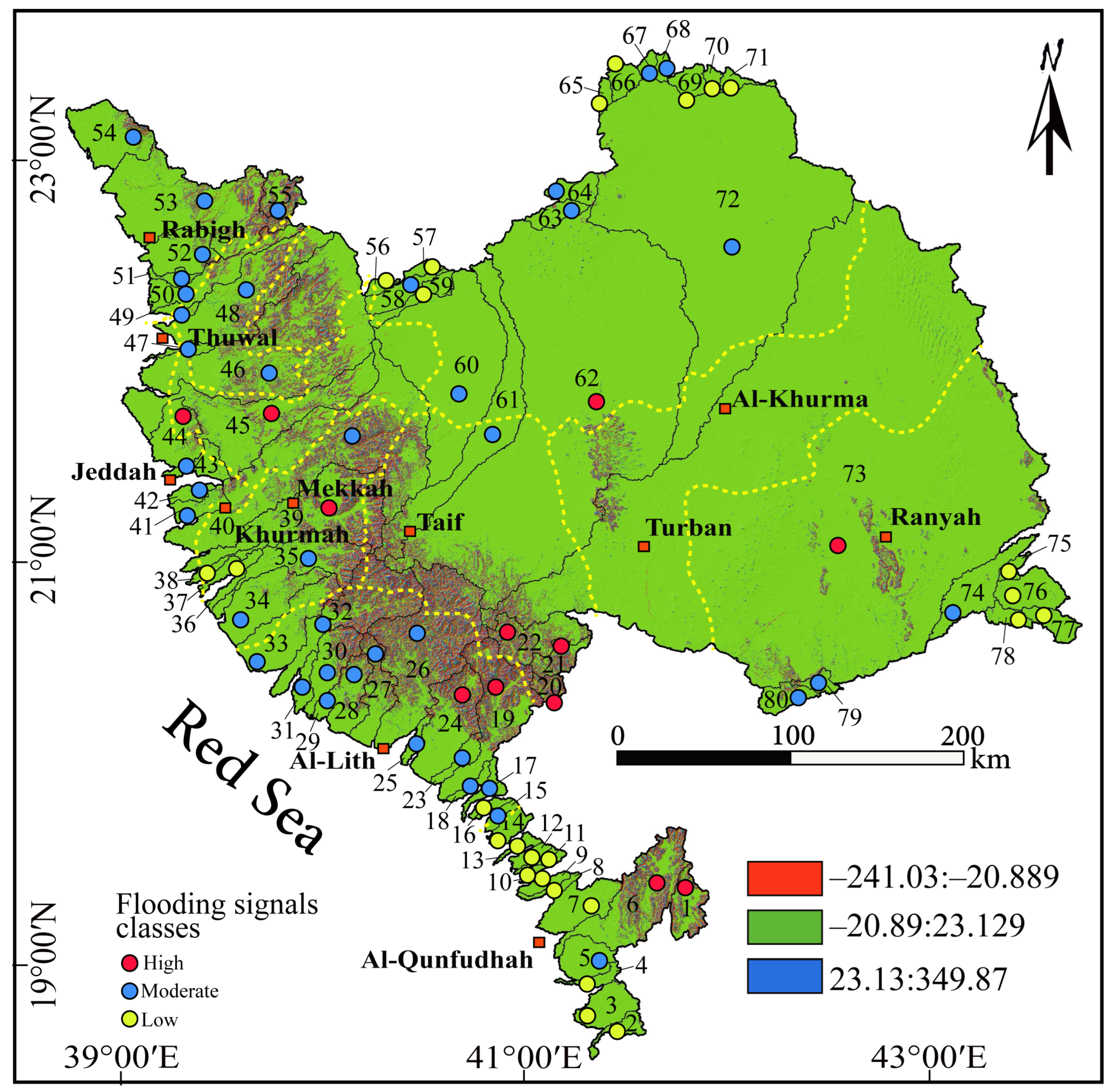
The topographic position index (TPI) is an effective, basic, and repeatable process to categorize different landscapes into landform groups and slope locations [53]. The altitudinal difference between the average height and the center point around a certain radius is known as the topographic position index (TPI) [48]. It can be computed by comparing the difference between the altitude of a specific cell and the altitude of the neighbors [62]. The size of the neighborhood, or the number of neighbors, has a significant impact (e.g., 5 × 5 vs. 19 × 19 vs. 61 × 61). A positive TPI shows that the center point is placed at a greater height, whereas a negative TPI shows that the central point is located at a lower altitude [63]. Different topographic landforms, such as slopes, valleys, and topographic ridges, can be identified with the use of TPI values [21,64,65]. The current research uses TPI processing to represent three distinct waterlogging probability values, ranging from −241.03 to 349.87 (Figure 10). Rather than regions with low-relief topography, the steep mountain margins typically exhibit the lowest potential conditions, leading to topographic flooding. The topographic position index is a very useful topographic factor for characterizing the physical equilibrium of the basin water driven by topography, the classification of topographic landscape locations, and drainage systems [66]. A positive TPI shows that the center point is placed at a greater height, whereas a negative TPI shows that the central point is located at a lower altitude. In the current study, Figure 10 presents three different reliefs, which are represented by three different colors. Blue zones, having positive values, are hilly areas, green parts, which are represented by values close to zero, are flat regions, and red parts, having minus values, are low-topography regions. Therefore, topographic slopes are detected, and landscape classifications are automated using TPI [53,67]. Significantly, the technique is valuable for flooding hazard research, which aims to determine the topographic preference of types of hydrological and geomorphological features (such as water runoff, soil, topography, land cover, and geology), because TPI can classify landscapes into morphological classes based on topography. In this work, we used topographic feature identification techniques such as TPI to identify high-relief ridges, depressions, and level plains. The TPI analysis identifies the regions with a high likelihood of waterlogging. We therefore assume that the topographic position index has a predominant and significant impact. Additionally, this index indicates that the researched catchments’ friction should be totally saturated [21,68]. With the help of this index, one can identify the water system’s topographic structure, learn more about drainage systems, and generate a distinctive runoff behavior figure [68].

4.5. Flash Flooding Hazard Vulnerability Classes

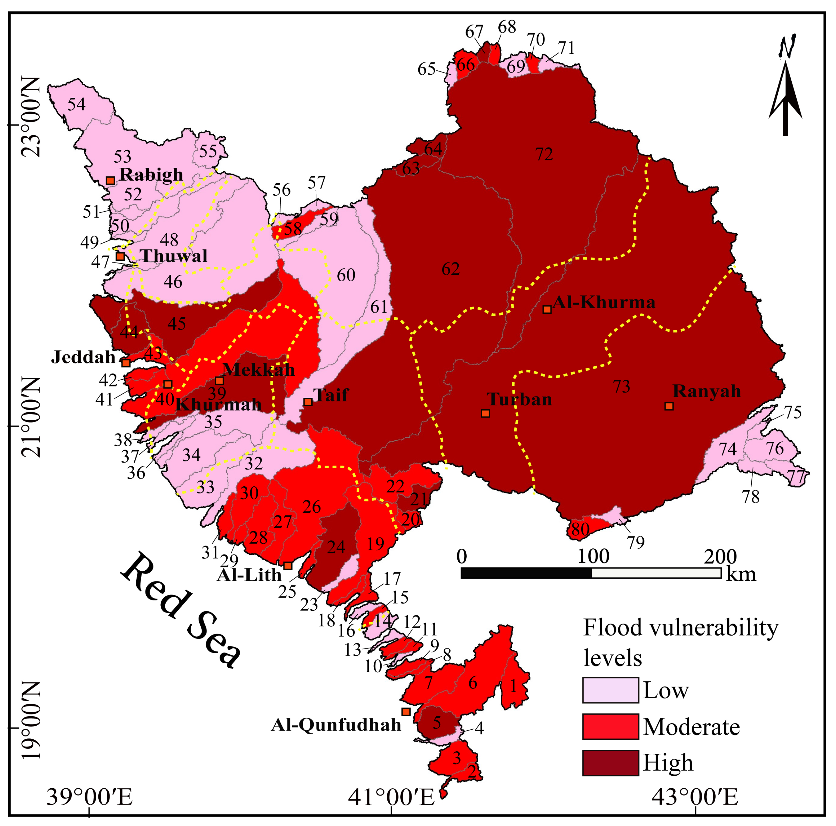
Overall, the comparison between results of the general watershed and ranked methods shows that the general watershed method map defines high signals of flooding hazards over more than half of the study area, whereas the general watershed method map assigns nearly half of the study province as having a low risk of flooding signals (Figure 11). The eastern edges of the study province were assigned values from moderate to high levels of flooding signals. Basins 4, 13, 14, 16, 36, 37, 38, 47, 49, 51, 56, 57, 58, 59, 61, 56, 68, 69, 74, 76, and 77 present a similar class of flooding hazard between the two applied methods (Figure 9c). They account for 13. 75% from the total study province. A comprehensive map was ultimately obtained by combining the three methods that were used (Figure 11). The current paper’s overall assessment reveals a completely different pattern of flood vulnerabilities. According to the analysis of this overall model, there is a 58.00% high degree of flood vulnerability covering mainly the central and eastern parts of the study province, a 15.40% moderate level, and a 26.58% low level.
In general, it has never been possible to fully predict or prevent the dynamic behaviors of abrupt environmental phenomena like flash floods. It is strongly advised to increase our understanding of past occurrences and refine our approaches and procedures to produce comprehensive models that can accurately predict future flood events and lessen the harmful consequences of flash flood events. As a result, significant strategies are needed to map flood vulnerability utilizing the most cutting-edge methods available. Two distinct yet efficient techniques were integrated to achieve the goals and categorize the research area into several zones vulnerable to flooding events. Every individual technique was effectively used to investigate different flash floods [8,53], However, we aimed to present this comprehensive approach here to offer significant insights into the likelihood of flood events and the features of the proposed province. By processing the weighted overlay step in ArcGIS 10.4 software, the catchment level susceptibility final map (Figure 11) can be combined in situ with one of the most useful and indicative topographic index (TPI) results (Figure 12). This allows us to precisely define the flash flood susceptibility for each individual part (30 m ~ 30 m pixel) in all the examined watersheds. The final analysis indicates that basins 1, 6, 19, 20, 21, 22, 24, 39, 44, 45, 62, and 73 offer high conditions of discharge production potential and are extremely susceptible to flooding hazard based on the various cumulative values collected using the adapted methodologies. These basins span 70,044.22 km2, accounting for 52.79% of the study province total area (Figure 12). A moderate degree of flash flood vulnerability is shown by the analysis of the morphometric indices using the two cumulative approaches for basins 5, 15, 17, 18, 23, 25:35, 40:46, 55, 58, 60:64, 72, 74, 79, and 80, which together account for 35.88% of the total area. The rest of the basins provide conditions for a low degree of flash flood vulnerability. Finally, we can apply the final analysis, which is illustrated in Figure 12, as an indicator to classify the study province into five distinct zones: the northwestern zone, which is characterized by moderate flooding vulnerability signals; the eastern zone, which provides conditions of moderate to high signals of flooding vulnerability; the western zone, which shows moderate signatures of flood vulnerability; the central zone, which is characterized by moderate to high conditions of flood vulnerability; and finally, the southern zone, which is covered mainly by low signals of flooding vulnerability.

5. Conclusions and Suggestions

Basin drainage management programs must identify the crucial watershed, since different basins exhibit distinct hydrological behaviors based on their morphometric and topological characteristics. Additionally, the morphometric characteristics aided in the comprehension of a variety of topographical features, including surface runoff, bedrock type, and infiltration capacity. In the current study, analysis tools in the ArcGIS 10.4 software, in addition to the digital elevation model (DEM) data, were effectively used in the current work to examine and analyze the extremely helpful morpho-metric indices. This study also demonstrated how to use an automated morphometric tool and demonstrated its capacity to determine geomorphometric parameters with reduced time and labor expenditure. These indices, influencing runoff volume, water depth, and flow velocity, were assessed over 80 basins of varying sizes that encompassed the study area. Using these indices, two effective quantitative approaches were conducted to evaluate and obtain a thorough grasp of the flooding hazard behaviors of Mekkah province, including the basin classes and ranking methods. The findings show that, in comparison to the other basins taken into consideration for this study, basins 5, 21, 24, 39, 44, 45, 63, 64, 67, 62, 72, and 73 provide conditions of high vulnerability to flash flood. These basins can create intense and huge discharges and reflect a high intensity level of flood events. While basins 5, 21, 24, 39, 44, and 45 encompass different portions of the western side of the study province along the Red Sea coast, basins 63, 64, 67, 62, 72, and 73 occupy the entire eastern side of the study terrain. This analysis is unusual and new because, in addition to the two distinct approaches using scale features, an effective local topographic index was a major help in accurately defining and tracking the flood vulnerability signals over all the 80 basins. Furthermore, there is debate on the vertical accuracy of the dataset used in this analysis (30 m resolution, SRTM, and RMSE = 8.28 m), which limits the usefulness of modifying the retrieved values and results at a particular scale and necessitates accurate information. The implications of other elements, such as lithology, land use, flood control, and hydraulic structures along the main rivers and channels, may cause the scenarios to differ because the flooding hazard events are not only dependent on morphometric characteristics. Additionally, the current work offers some recommendations for enhancing the study’s flood risk assessment and quick response system, which can then be successfully implemented in other areas with comparable circumstances. In this study, some recommendations are summed up as follows. (a) Research should concentrate on using the most cutting-edge, contemporary techniques and data to closely monitor and assess this kind of significant risk; (b) more consideration should be given to frequent updates of the climate datasets; (c) monitoring stations and reaction systems should be set up to provide early danger warning systems; and (d) considerable measures, like hazard communication, should be taken to lessen the consequences of flood hazards and maintain a stable and safe environment.

Supplementary Materials

The following supporting information can be downloaded at: https://www.mdpi.com/article/10.3390/w16192714/s1, Table S1: Basic geometric characteristics of the study province.; Table S2: Stream orders (Os) and stream numbers (Ns) of the study province.

Author Contributions

Conceptualization, B.B. and A.A.; methodology, B.B.; software, B.B. and A.A.; validation, B.B.; formal analysis, B.B. and A.A.; investigation, B.B. and A.A.; resources, A.A.; data curation, B.B.; writing—review and editing, A.A.; visualization, B.B. and A.A.; supervision, B.B. and A.A.; project administration, B.B. and A.A.; funding acquisition, B.B. and A.A. All authors have read and agreed to the published version of the manuscript.

Funding

This research was supported by the Researchers Supporting Project, Grant number (RSP2024R296), King Saud University, Riyadh, Saudi Arabia.

Data Availability Statement

The raw data supporting the conclusions of this article will be made available by the authors on request.

Conflicts of Interest

The authors declare no conflicts of interest.

References

  1. Alarifi, S.S.; Abdelkareem, M.; Abdalla, F.; Alotaibi, M. Flash Flood Hazard Mapping Using Remote Sensing and GIS Techniques in Southwestern Saudi Arabia. Sustainability 2022, 14, 14145. [Google Scholar] [CrossRef]
  2. Elkhrachy, I. Flash Flood Hazard Mapping Using Satellite Images and GIS Tools: A case study of Najran City, Kingdom of Saudi Arabia (KSA). Egypt. J. Remote Sens. Space Sci. 2015, 18, 261–278. [Google Scholar] [CrossRef]
  3. Abdalla, F.; El Shamy, I.; Bamousa, A.O.; Mansour, A.; Mohamed, A.; Tahoon, M. Flash Floods and Groundwater Recharge Potentials in Arid Land Alluvial Basins, Southern Red Sea Coast, Egypt. Int. J. Geosci. 2014, 5, 971–982. [Google Scholar] [CrossRef]
  4. Şen, Z.; Khiyami, H.A.; Al-Harthy, S.G.; Al-Ammawi, F.A.; Al-Balkhi, A.B.; Al-Zahrani, M.I.; Al-Hawsawy, H.M. Flash flood inundation map preparation for wadis in arid regions. Arab. J. Geosci. 2013, 6, 3563–3572. [Google Scholar] [CrossRef]
  5. Abdelkareem, M. Targeting flash flood potential areas using remotely sensed data and GIS techniques. Nat. Hazards 2017, 85, 19–37. [Google Scholar] [CrossRef]
  6. Collier, C.G. Flash flood forecasting: What are the limits of predictability? Q. J. R. Meteorol. Soc. A J. Atmos. Sci. Appl. Meteorol. Phys. Oceanogr. 2007, 133, 3–23. [Google Scholar] [CrossRef]
  7. Carpenter, T.M.; Sperfslage, J.A.; Georgakakos, K.P.; Sweeney, T.; Fread, D.L. National threshold runoff estimation utilizing GIS in support of operational flash flood warning systems. J. Hydrol. 1999, 224, 21–44. [Google Scholar] [CrossRef]
  8. Khalifa, A.; Bashir, B.; Alsalman, A.; Naik, S.P.; Nappi, R. Remotely Sensed Data, Morpho-Metric Analysis, and Integrated Method Approach for Flood Risk Assessment: Case Study of Wadi Al-Arish Landscape, Sinai, Egypt. Water 2023, 15, 1797. [Google Scholar] [CrossRef]
  9. Wilford, D.J.; Sakals, M.E.; Innes, J.L.; Sidle, R.C.; Bergerud, W.A. Recognition of debris flow, debris flood and flood hazard through watershed morphometrics. Landslides 2004, 1, 61–66. [Google Scholar] [CrossRef]
  10. Charlton, R.; Fealy, R.; Moore, S.; Sweeney, J.; Murphy, C. Assessing the impact of climate change on water supply and flood hazard in Ireland using statistical downscaling and hydrological modelling techniques. Clim. Chang. 2006, 74, 475–491. [Google Scholar] [CrossRef]
  11. Khosravi, K.; Pourghasemi, H.R.; Chapi, K.; Bahri, M. Flash flood susceptibility analysis and its mapping using different bivariate models in Iran: A comparison between Shannon’s entropy, statistical index, and weighting factor models. Environ. Monit. Assess. 2016, 188, 656. [Google Scholar] [CrossRef] [PubMed]
  12. Ullah, K.; Zhang, J. GIS-based flood hazard mapping using relative frequency ratio method: A case study of panjkora river basin, eastern Hindu Kush, Pakistan. PLoS ONE 2020, 15, e0229153. [Google Scholar] [CrossRef]
  13. Papaioannou, G.; Efstratiadis, A.; Vasiliades, L.; Loukas, A.; Papalexiou, S.M.; Koukouvinos, A.; Tsoukalas, I.; Kossieris, P. An operational method for Flood Directive implementation in ungauged urban areas. Hydrology 2018, 5, 24. [Google Scholar] [CrossRef]
  14. Abdulrazzak, M.; Elfeki, A.; Kamis, A.S.; Kassab, M.; Alamri, N.; Noor, K.; Chaabani, A. The impact of rainfall distribution patterns on hydrological and hydraulic response in arid regions: Case study Medina, Saudi Arabia. Arab. J. Geosci. 2018, 11, 679. [Google Scholar] [CrossRef]
  15. Ewea, H.A.; Elfeki, A.M.M.; Bahrawi, J.A.; Al-Amri, N.S. Sensitivity analysis of runoff hydrographs due to temporal rainfall patterns in Makkah Al-Mukkramah region, Saudi Arabia. Arab. J. Geosci. 2016, 9, 424. [Google Scholar] [CrossRef]
  16. Elfeki, A.; Bahrawi, J. Application of the random walk theory for simulation of flood hazards: Jeddah flood 25 November 2009. Int. J. Emerg. Manag. 2017, 13, 169. [Google Scholar] [CrossRef]
  17. Azeez, O.; Elfeki, A.; Kamis, A.S.; Chaabani, A. Dam break analysis and flood disaster simulation in arid urban environment: The Um Al-Khair dam case study, Jeddah, Saudi Arabia. Nat. Hazards 2020, 100, 995–1011. [Google Scholar] [CrossRef]
  18. Farran, M.M.; Elfeki, A.M. Evaluation and validity of the antecedent moisture condition (AMC) of Natural Resources Conservation Service-Curve Number (NRCS-CN) procedure in undeveloped arid basins. Arab. J. Geosci. 2020, 13, 275. [Google Scholar] [CrossRef]
  19. Al-Wagdany, A.; Elfeki, A.; Kamis, A.S.; Bamufleh, S.; Chaabani, A. Effect of the stream extraction threshold on the morphological characteristics of arid basins, fractal dimensions, and the hydrologic response. J. Afr. Earth Sci. 2020, 172, 103968. [Google Scholar] [CrossRef]
  20. Bathrellos, G.D.; Karymbalis, E.; Skilodimou, H.D.; Gaki-Papanastassiou, K.; Baltas, E.A. Urban flood hazard assessment in the basin of Athens Metropolitan city, Greece. Environ. Earth Sci. 2016, 75, 319. [Google Scholar] [CrossRef]
  21. Bashir, B.; Alsalman, A. Morpho-Hydrological Analysis and Preliminary Flash Flood Hazard Mapping of Neom City, Northwestern Saudi Arabia, Using Geospatial Techniques. Sustainability 2024, 16, 23. [Google Scholar] [CrossRef]
  22. Manzoor, Z.; Ehsan, M.; Khan, M.B.; Manzoor, A.; Akhter, M.M.; Sohail, M.T.; Hussain, A.; Shafi, A.; Abu-Alam, T.; Abioui, M. Floods and flood management and its socio-economic impact on Pakistan: A review of the empirical literature. Front. Environ. Sci. 2022, 10, 1021862. [Google Scholar] [CrossRef]
  23. Sohail, M.T.; Hussan, A.; Ehsan, M.; Al-Ansari, N.; Akhter, M.M.; Manzoor, Z.; Elbeltagi, A. Groundwater budgeting of Nari and Gaj formations and groundwater mapping of Karachi, Pakistan. Appl. Water Sci. 2022, 12, 267. [Google Scholar] [CrossRef]
  24. Ahmad, N.; Khan, S.; Ehsan, M.; Rehman, F.U.; Al-Shuhail, A. Estimating the Total Volume of Running Water Bodies Using Geographic Information System (GIS): A Case Study of Peshawar Basin (Pakistan). Sustainability 2022, 14, 3754. [Google Scholar] [CrossRef]
  25. Khalifa, A.; Bashir, B.; Alsalman, A.; Bachir, H. Morphometric-Hydro Characterization of the Coastal Line between El-Qussier and Marsa-Alam, Egypt: Preliminary Flood Risk Signatures. Appl. Sci. 2022, 12, 6264. [Google Scholar] [CrossRef]
  26. Li, Z.; Zhang, Y.; Wang, J.; Ge, W.; Li, W.; Song, H.; Guo, X.; Wang, T.; Jiao, Y. Impact evaluation of geomorphic changes caused by extreme floods on inundation area considering geomorphic variations and land use types. Sci. Total Environ. 2021, 754, 142424. [Google Scholar] [CrossRef]
  27. Vincent, L.T.; Eaton, B.C.; Leenman, A.S.; Jakob, M. Secondary Geomorphic Processes and Their Influence on Alluvial Fan Morphology, Channel Behavior and Flood Hazards. J. Geophys. Res. Earth Surf. 2022, 127, e2021JF006371. [Google Scholar] [CrossRef]
  28. Patton, P.C.; Baker, V.R. Morphometry and floods in small drainage basins subject to diverse hydrogeomorphic controls. Water Resour. Res. 1976, 12, 941–952. [Google Scholar] [CrossRef]
  29. Niyazi, B.; Khan, A.A.; Masoud, M.; Elfeki, A.; Basahi, J.; Zaidi, S. Morphological-hydrological relationships and the geomorphological instantaneous unit hydrograph of Makkah Al-Mukarramah watersheds. Arab. J. Geosci. 2021, 14, 751. [Google Scholar] [CrossRef]
  30. Hamimi, Z.; Fowler, A.R.; Liégeois, J.P.; Collins, A.; Abdelsalam, M.G.; Abd El-Wahed, M. Regional Geology Reviews The Geology of the Arabian-Nubian Shield. [Online]. Available online: http://www.springer.com/series/8643 (accessed on 1 May 2024).
  31. Angillieri, M.Y.E. Morphometric characterization of the Carrizal basin applied to the evaluation of flash floods hazard, San Juan, Argentina. Quat. Int. 2012, 253, 74–79. [Google Scholar] [CrossRef]
  32. Pareta, D.R.; Pareta, U. Quantitative geomorphological analysis of a watershed of Ravi River basin, H.P. India. IJRS GIS. 2012, 1, 47–62. [Google Scholar]
  33. Perucca, L.P.; Angilieri, Y.E. Morphometric characterization of del Molle Basin applied to the evaluation of flash floods hazard, Iglesia Department, San Juan, Argentina. Quat. Int. 2011, 233, 81–86. [Google Scholar] [CrossRef]
  34. Wani, M.B.; Ali, S.A.; Ali, U. Flood Assessment of Lolab Valley from Watershed Characterization Using Remote Sensing and GIS Techniques. In Hydrologic Modeling: Select Proceedings of ICWEES-2016; Springer: Singapore, 2018; pp. 367–390. [Google Scholar] [CrossRef]
  35. Ali, A.; Beg, F. Morphometric Toolbox: A New Technique in Basin Morphometric Analysis Using ArcGIS. 2015. [Online]. Available online: http://www.arcgis.com/home/item.html?id=1953627829a64102a7183327b4727 (accessed on 1 May 2024).
  36. El Hamdouni, R.; Irigaray, C.; Fernández, T.; Chacón, J.; Keller, E.A. Assessment of relative active tectonics, southwest border of the Sierra Nevada (southern Spain). Geomorphology 2008, 96, 150–173. [Google Scholar] [CrossRef]
  37. Khalifa, A.; Çakir, Z.; Owen, L.A.; Kaya, Ş. Morphotectonic analysis of the East Anatolian Fault, Turkey. Turk. J. Earth Sci. 2018, 27, 110–126. [Google Scholar] [CrossRef]
  38. Bajabaa, S.; Masoud, M.; Al-Amri, N. Flash flood hazard mapping based on quantitative hydrology, geomorphology and GIS techniques (case study of Wadi Al Lith, Saudi Arabia). Arab. J. Geosci. 2014, 7, 2469–2481. [Google Scholar] [CrossRef]
  39. Davis, J.C. Statistics and Data Analysis in Geology, 3rd ed.; Wiley: New York, NY, USA, 2014. [Google Scholar]
  40. Horton, R.E. Erosional development of streams and their drainage basins; Hydrophysical approach to quantitative morphology. Bull. Geol. Soc. Am. 1945, 56, 275–370. [Google Scholar] [CrossRef]
  41. Khalifa, A.; Bashir, B.; Alsalman, A.; Öğretmen, N. Morpho-tectonic assessment of the abu-dabbab area, eastern desert, egypt: Insights from remote sensing and geospatial analysis. ISPRS Int. J. Geoinf. 2021, 10, 784. [Google Scholar] [CrossRef]
  42. Schumm, S.A. Evolution of drainage systems and slopes in badlands at Perth Amboy, New Jersey. Bull. Geol. Soc. Am. 1956, 67, 597–646. [Google Scholar] [CrossRef]
  43. Strahler, A.N. Hypsometric (area-altitude) analysis of erosional topography. Bull. Geol. Soc. Am. 1952, 63, 1117–1142. [Google Scholar] [CrossRef]
  44. Chorley, R. “Horton, R.E. 1945: Erosional development of streams and their drainage basins: Hydrophysical approach to quantitative morphology. Bulletin of the Geological Society of America 56, 275–370.”. Prog. Phys. Geogr. 1995, 19, 533–554. [Google Scholar] [CrossRef]
  45. Smith, K.G. Standards for grading texture of erosional topography. Am. J. Sci. 1950, 248, 655–668. [Google Scholar] [CrossRef]
  46. Saha, S.; Das, J.; Mandal, T. Investigation of the watershed hydro-morphologic characteristics through the morphometric analysis: A study on Rayeng basin in Darjeeling Himalaya. Environ. Chall. 2022, 7, 100463. [Google Scholar] [CrossRef]
  47. Melton, F.A. Aerial Photographs and Structural Geomorphology. J. Geol. 1959, 67, 351–370. [Google Scholar] [CrossRef]
  48. Weiss, A. Topographic position and landforms analysis. In Proceedings of the Poster Presentation, ESRI User Conference, San Diego Convention Center, San Diego, CA, USA, 9–13 July 2001; Volume 64. [Google Scholar]
  49. Tariq, M.A.U.R.; Van De Giesen, N. Giesen Floods and flood management in Pakistan. Phys. Chem. Earth 2012, 47–48, 11–20. [Google Scholar] [CrossRef]
  50. Bhatt, S.; Ahmed, S.A. Morphometric analysis to determine floods in the Upper Krishna basin using Cartosat DEM. Geocarto Int. 2014, 29, 878–894. [Google Scholar] [CrossRef]
  51. Khalifa, A. Preliminary Active Tectonic Assessment Of Wadi Ghoweiba Catchment, Gulf of Suez Rift, Egypt, Integration of Remote Sensing, Tectonic Geomorphology, and Gis Techniques. 2020. [Online]. Available online: https://absb.journals.ekb (accessed on 1 May 2024).
  52. Bharadwaj, A.K.; Thirumalaivasan, D.; Shankar, C.P.; Madhavan, N. Morphometric Analysis of Adyar Watershed. [Online]. Available online: www.iosrjournals.org (accessed on 1 May 2024).
  53. Alam, A.; Ahmed, B.; Sammonds, P. Flash flood susceptibility assessment using the parameters of drainage basin morphometry in SE Bangladesh. Quat. Int. 2021, 575–576, 295–307. [Google Scholar] [CrossRef]
  54. Mesa, L.M. Morphometric analysis of a subtropical Andean basin (Tucumán, Argentina). Environ. Geol. 2006, 50, 1235–1242. [Google Scholar] [CrossRef]
  55. Reddy, G.P.O.; Maji, A.K.; Gajbhiye, K.S. Drainage morphometry and its influence on landform characteristics in a basaltic terrain, Central India—A remote sensing and GIS approach. Int. J. Appl. Earth Obs. Geoinf. 2004, 6, 1–16. [Google Scholar] [CrossRef]
  56. Gregory, K.J.; Wallingford, D.E. Drainage Basin Form and Process—A Geomorphological Approach. Soil Sci. Soc. Am. J. 1973, 38, vi. [Google Scholar] [CrossRef]
  57. Hamid, R.A.H.A. Application of Morphometric Analysis for Geo-Hydrological Studies Using Geo-Spatial Technology—A Case Study of Vishav Drainage Basin. J. Waste Water Treat. Anal. 2013, 4, 1–12. [Google Scholar] [CrossRef]
  58. Azor, A.; Keller, E.A.; Yeats, R.S. Geomorphic indicators of active fold growth: South Mountain-Oak Ridge anticline, Ventura basin, southern California. Bull. Geol. Soc. Am. 2002, 114, 745–753. [Google Scholar] [CrossRef]
  59. Pérez-Peña, J.V.; Azor, A.; Azañón, J.M.; Keller, E.A. Active tectonics in the Sierra Nevada (Betic Cordillera, SE Spain): Insights from geomorphic indexes and drainage pattern analysis. Geomorphology 2010, 119, 74–87. [Google Scholar] [CrossRef]
  60. Kabite, G.; Gessesse, B. Hydro-geomorphological characterization of Dhidhessa River Basin, Ethiopia. Int. Soil Water Conserv. Res. 2018, 6, 175–183. [Google Scholar] [CrossRef]
  61. Hare, P.W.; Gardner, T.W. Geomorphic Indicators of Vertical Neotectonism along Converging Plate Margins, Nicoya Peninsula Costa Rica. In Tectonic Geomorphology: Proceedings of the 15th Annual Binghamton Geomorphology Symposium, 4; Allen and Unwin: Boston, MA, USA, 1985; pp. 123–134. [Google Scholar]
  62. Costache, R. Flash-flood Potential Index mapping using weights of evidence, decision Trees models and their novel hybrid integration. Stoch. Environ. Res. Risk Assess. 2019, 33, 1375–1402. [Google Scholar] [CrossRef]
  63. Arabameri, A.; Saha, S.; Chen, W.; Roy, J.; Pradhan, B.; Bui, D.T. Flash flood susceptibility modelling using functional tree and hybrid ensemble techniques. J. Hydrol. 2020, 587, 125007. [Google Scholar] [CrossRef]
  64. Pawluszek, K.; Borkowski, A. Impact of DEM-derived factors and analytical hierarchy process on landslide susceptibility mapping in the region of Rożnów Lake, Poland. Nat. Hazards 2017, 86, 919–952. [Google Scholar] [CrossRef]
  65. Khalifa, A. Application of Remote sensing techniques in discrimination of rock units and preliminary assessment of tectonic activity using ASTER and ALOSE-PALSAR data at Gabal Delihimmi, Central Eastern Desert, Egypt. Egypt. J. Geol. 2023, 67, 287–298. [Google Scholar] [CrossRef]
  66. Görüm, T. Tectonic, topographic and rock-type influences on large landslides at the northern margin of the Anatolian Plateau. Landslides 2019, 16, 333–346. [Google Scholar] [CrossRef]
  67. De Reu, J.; Bourgeois, J.; Bats, M.; Zwertvaegher, A.; Gelorini, V.; De Smedt, P.; Chu, W.; Antrop, M.; De Maeyer, P.; Finke, P.; et al. Application of the topographic position index to heterogeneous landscapes. Geomorphology 2013, 186, 39–49. [Google Scholar] [CrossRef]
  68. Woods, R.A.; Sivapalan, M. A connection between topographically driven runoff generation and channel network structure. In Water Resources Research; Blackwell Publishing Ltd.: Oxford, UK, 1997; pp. 2939–2950. [Google Scholar] [CrossRef]
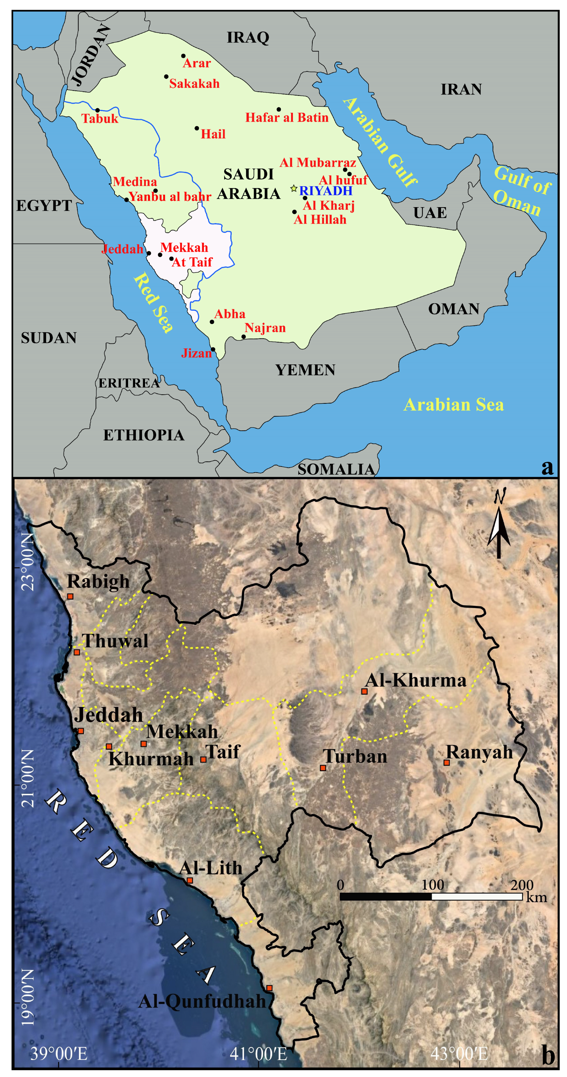
Figure 1. (a) Location map of Saudi Arabia and surroundings (blue line bounds Hejaz terrain from east to the Red Sea coast and white polygon indicates the location of Mekkah province); (b) Google Earth image showing the shape of Mekkah province (yellow dashed lines indicate the boundaries of the cities, including in Mekkah province).
Water 16 02714 g001
Figure 2. Geological map of Mekkah province.
Water 16 02714 g002
Figure 3. Topographical map of Mekkah province.
Water 16 02714 g003
Figure 4. Figures present mean annual rainfall amount data in Mekkah province (modified after Ref. [29]).
Water 16 02714 g004
Figure 5. Distribution and amount of the mean annual rainfall data of Mekkah province between 2011 and 2020.
Water 16 02714 g005
Figure 6. Scheme showing the applied methods and steps.
Water 16 02714 g006
Figure 7. (a) Delineated basins from 1 to 80, which were extracted by the hydrology tools in the ArcGIS, and (b) stream orders of the study basins, ranging from order 1 up to order 6.
Water 16 02714 g007
Figure 8. Morphometric indices applied in this study. Ns: stream number; Ls: stream length; Rb: bifurcation ratio; Fs: stream frequency; F: form factor; Rt: texture ratio; Dd: drainage density; If: infiltration number; Br: basin relief; Nr: ruggedness number; and Rr: elevation relief ratio.
Water 16 02714 g008
Figure 9. (a) Map showing the levels of flooding vulnerability due to the watershed method; (b) map showing the levels of flooding vulnerability due to the ranked method; and (c) chart illustrating numbers present and the compatibility levels for the two applied methods.
Water 16 02714 g009
Figure 10. Relief map of Mekkah province defining different topographical classes prepared by the topographic position index (TPI).
Water 16 02714 g010
Figure 11. Flood hazard vulnerability signals due to the integration between the general watershed and ranked methods.
Water 16 02714 g011
Figure 12. Final flooding hazard vulnerability model of Mekkah province.
Water 16 02714 g012
Table 3. Estimated values of morphometric indices for every individual basin.
BasinsNsLsRbFsFRtDdIfBrNrRr
12639.594.50.050.280.1872.530.6611040.8025.16
2910.480.040.180.0645.480.863380.159.44
32549.073.830.040.430.1888.230.514820.4313.35
432.920.020.130.0217.631.033170.068.76
52246.172.430.040.540.1684.910.4826902.2884.75
66581.618.460.040.190.1944.450.8022180.9922.33
73461.173.230.040.290.1878.380.566190.4911.95
811.25Null0.010.080.0111.320.802820.037.71
966.6550.030.200.0637.300.901620.065.37
1032.920.050.120.0451.991.031310.076.16
1166.6550.050.130.0657.140.902270.137.53
1255.440.030.240.0633.700.921930.077.49
1355.440.050.150.0550.320.921350.075.04
141123.3730.040.340.1189.750.472820.2510.23
1555.440.040.210.0744.580.922760.1211.42
1666.6550.050.180.0855.450.902260.138.82
1755.440.020.230.0326.380.922170.067.30
1844.1530.030.120.0432.670.962140.076.44
1984135.343.920.050.230.2476.740.6226362.0230.30
201011.6590.050.470.1458.300.8610400.6150.63
211224.623.250.030.270.0967.160.499950.6727.11
224380.363.110.050.370.1988.050.5413501.1927.34
23910.480.040.150.0743.700.8612170.5331.02
2454106.263.70.040.300.2377.520.5118861.4627.68
2555.440.040.140.0538.290.926020.2318.75
26134239.693.330.040.270.3074.340.5626691.9824.64
272640.444.620.040.180.1157.190.6417571.0028.05
282954.070.750.040.330.1779.230.549810.7821.54
2966.6550.050.350.0960.070.902700.1615.14
30460.733.020.010.230.0285.710.0715751.3528.52
311325.0330.060.170.11109.260.522010.225.53
3274115.743.90.040.170.2165.850.6426131.7225.57
335392.023.410.040.240.2175.570.5815061.1421.01
345594.523.470.050.270.2283.600.586330.539.76
355281.143.70.040.150.1566.480.6426141.7428.88
3655.440.040.140.0547.450.921500.075.29
3777.960.030.130.0535.540.892230.085.39
3866.6550.040.070.0439.610.903080.126.25
391021574.280.040.190.2266.610.6526141.7423.61
40214329.593.80.040.220.3060.680.6523401.4214.78
411427.123.750.050.290.1189.400.525490.4916.86
42920.872.50.050.260.10122.960.432570.3210.07
431527.533.330.040.340.0980.570.546880.5521.63
443256.982.80.040.990.1876.210.565550.4220.19
45106151.544.550.040.160.1955.640.7013220.7410.07
46201302.883.750.040.340.3857.880.6616250.9413.10
4744.1530.030.100.0330.560.961920.065.16
4884125.724.110.040.190.2356.550.6715810.8914.68
4955.440.040.170.0644.500.921890.086.99
504066.983.260.050.100.1276.690.6013581.0414.42
51920.872.50.060.180.08146.040.431190.174.17
522652.012.910.030.510.1470.000.506050.4215.78
53140243.823.30.041.680.2978.180.5712841.0029.77
545986.533.880.050.420.2678.980.6813921.1027.21
551831.283.830.040.580.1469.620.589050.6332.62
5644.1530.040.240.0643.480.963500.1517.40
57920.032.330.080.190.11171.130.452050.358.33
581527.533.330.040.160.1074.230.546380.4713.32
591325.873.50.040.110.0881.490.505760.4710.88
60181290.553.480.040.280.4067.000.626440.435.21
6183148.774.10.040.070.1364.850.5617081.119.60
626641049.43.620.040.800.6559.960.6317001.0211.48
631528.3740.051.650.1399.290.534480.4434.02
641729.193.50.050.430.1692.180.584830.4517.72
6532.920.030.240.0425.121.031060.034.82
661123.3730.040.850.1289.340.471000.095.71
6766.6550.060.430.1063.290.90760.054.84
68819.622.250.070.360.13181.010.41750.144.32
691022.122.750.040.580.1085.280.451430.126.75
7055.440.050.350.0851.370.92980.055.63
7166.6550.040.880.0547.150.901160.059.16
72565907.194.720.041.610.5864.230.625630.366.01
73164543794.20.041.311.05110.250.3818422.0310.56
743156.572.880.030.130.1162.280.553130.193.76
7566.6550.050.230.0852.200.902000.108.57
762639.594.50.040.420.1762.280.662450.156.28
771526.683.250.050.310.1381.770.561960.166.03
78910.480.040.360.0949.320.863710.1815.24
791021.282.50.060.210.10125.840.473710.4713.17
801325.873.50.040.340.1176.930.503700.2811.81
Disclaimer/Publisher’s Note: The statements, opinions and data contained in all publications are solely those of the individual author(s) and contributor(s) and not of MDPI and/or the editor(s). MDPI and/or the editor(s) disclaim responsibility for any injury to people or property resulting from any ideas, methods, instructions or products referred to in the content.