Article

Assessment of Potential Aquifer Recharge Zones in the Locumba Basin, Arid Region of the Atacama Desert Using Integration of Two MCDM Methods: Fuzzy AHP and TOPSIS

1
Department of Geology-Geotechnics, Jorge Basadre Grohmann National University, Tacna 23000, Peru
2
Department of Civil Engineering, Jorge Basadre Grohmann National University, Tacna 23000, Peru
3
Laboratory of Ecological Processes, Research Group of Arid Zones, Deserts and Climate Change (ADERIZA), Jorge Basadre Grohmann National University, Tacna 23000, Peru
4
Civil Engineering Department, New Mexico State University, Las Cruces, NM 88003, USA
*
Author to whom correspondence should be addressed.
Water 2024, 16(18), 2643; https://doi.org/10.3390/w16182643
Submission received: 10 July 2024 / Revised: 12 September 2024 / Accepted: 16 September 2024 / Published: 18 September 2024

Abstract

:
Natural aquifers used for human consumption are among the most important resources in the world. The Locumba basin faces significant challenges due to its limited water availability for the local population. In this way, the search for possible aquifer recharge zones is crucial work for urban development in areas that have water scarcity. To evaluate this problem, this research proposes the use of the hybrid Fuzzy AHP methodology in conjunction with the TOPSIS algorithm to obtain a potential aquifer recharge map. Ten factors that influence productivity and capacity in an aquifer were implemented, which were subjected to Fuzzy AHP to obtain their weighting. Using the TOPSIS algorithm, the delineation of the most favorable areas with high recharge potential was established. The result shows that the most influential factors for recharge are precipitation, permeability, and slopes, which obtained the highest weights of 0.22, 0.19, and 0.17, respectively. In parallel, the TOPSIS result highlights the potential recharge zones distributed in the Locumba basin, which were classified into five categories: very high (13%), high (28%), moderate (15%), low (28%), and very low (16%). The adapted methodology in this research seeks to be the first step toward effective water resource management in the study area.

1. Introduction

Water is the most dynamic natural resource on Earth, playing a significant role in human life, economic development, social development, and the maintenance of ecological systems [1,2]. Water scarcity is one of the most important global problems in recent decades, and its occurrence occurs especially in developing countries where there is an inadequate supply of water [3]. Thus, the role of water resources and the management of their consumption is of primary importance due to the increase in water demand [4]. Groundwater is a vital natural resource for the supply of drinking water in both urban and rural environments [5]. It plays an important role in human well-being, ecological balance, and economic growth [6]. Favorable conditions for groundwater formation are subject to the climate, geology, hydrogeology, and ecological aspects of an area [7,8]. Therefore, assessing and protecting groundwater quality is vital to understanding our water resources and effectively managing groundwater [9].
Peru faces significant challenges due to the excessive extraction of its water resources, leading to water transfer projects from the mountains to the coast, where the majority of the population is located [10]. In southern Peru, the Tacna region is situated in the Atacama Desert, one of the world’s most hyperarid deserts [11]. This results in a dry climate, with the hyperaridity attributed to its subtropical location [12,13,14,15,16]. The residents of the Locumba basin have reported cases in which the region has suffered a water deficit that caused a shortage of drinking water [17]. Additionally, governmental mismanagement exacerbates the issue, as there is an ongoing struggle for groundwater due to a lack of specific legislation, creating significant uncertainty regarding the future of water management for the residents [18].
Within the framework of studies of the Atacama Desert, several investigations were carried out in search of analyzing the inherent problems that a hyperarid desert brings. The effects of the hyperarid climate on crops within the Atacama Desert were analyzed [19,20,21,22], where the presence of water stress, which affects the efficiency of agricultural production, was highlighted. Research was also carried out about saline intrusion and how it is characterized in coastal areas of the Atacama Desert, bringing with it a deterioration in the quality of groundwater exploited by residents [23,24,25]. Additionally, studies have been carried out on the effects of overexploitation of the various arid aquifers present, reaching the conclusion that these aquifers are exploited in excess related to the recharge capacity they have, generating an unbalanced extraction environment [26,27,28]. Based on the indicated research, the aquifers present within the Atacama Desert have alarming unfavorable characteristics in the use and management of their water resources.
Thus, this study aims to analyze the recharge potential of aquifers because of the lack of adequate information and research about the water available in the Locumba basin. Therefore, it is proposed to create a map to establish the delineation of areas with high recharge capacity. To achieve this objective, the combination of two multi-criteria decision analysis (MCDM) methods was used since these guarantee rewarding approaches to solving multi-level decision-making processes. Numerous studies have applied the combination presented in this research [29,30,31,32] in order to increase the robustness of the framework, showing successful results. In the foreground is Fuzzy AHP, which through the integration of fuzzy set principles offers a more reliable and comprehensive approach to handling complex problems and supports decision-making processes [32]. While classic AHP is a process that is based on the comparison of decision criteria with each other to estimate the weight of each criterion [33,34], the standard AHP methodology has certain limitations, particularly associated with the incorporation of the inherent fuzziness of human judgment [35]. In second place is TOPSIS, which is based on the concept that the ideal alternative has the best level for all attributes, while the negative ideal is the one that has the worst attribute values [36].
With water demand likely to increase both in the short and long terms, pressures on groundwater resources are expected to intensify [37]. This requires the execution of new research campaigns aimed at addressing the problem of water scarcity. However, conducting studies in such a large area requires a lot of time and investment in extensive logistics [38]. Fortunately, with the help of Geographic Information System (GIS) tools capable of storing and processing spatial data [39], and in conjunction with accessible data from remote sensors and maps, it is possible to conduct extensive studies without the need for large-scale field campaigns. Therefore, this research aims to meet the following objectives: (i) propose a model of viable aquifer recharge zones in the Locumba basin, addressing the current lack of research in this area; (ii) employ the Fuzzy Analytic Hierarchy Process (AHP) methodology to determine which criteria have the greatest influence on aquifer recharge potential; and (iii) generate a final map of aquifer recharge potential through the application of the Technique for Order Preference by Similarity to Ideal Solution (TOPSIS) method. In this way, the completion of this study will provide an effective spatial visualization of suitable natural aquifer recharge sites, contributing to efforts to mitigate the water crisis in the Locumba basin. Additionally, this approach demonstrates the potential of combining GIS tools and remote sensing data to facilitate and improve large-scale groundwater research, offering a cost-effective and efficient alternative to traditional field campaigns.

2. Study Area

2.1. Climate and Hydrology

The Locumba basin is located in the Tacna region, within the province of Candarave and Locumba, presenting an area of 5742.34 km2 [40]. It is limited in the north by the dividing line of the Chilota and Vizcachas River basins, in the south by the Pacific Ocean, in the east by the Sama River basin, and in the west by the Moquegua River basin (Figure 1). The Locumba basin presents three clearly differentiated zones: the upper basin, from Suches lagoon to Aricota lagoon; the middle basin, located in the Locumba valley; and the lower basin, including the mouth in the bay’s wetlands [41]. The climate is characterized by arid conditions, with average annual rainfall on the coast of less than 10 mm and in the highlands of 400 mm [42]. It has a historical average temperature of 19.1 °C, with an average maximum of 25.9 °C in March and an average minimum of 12.7 °C in July.
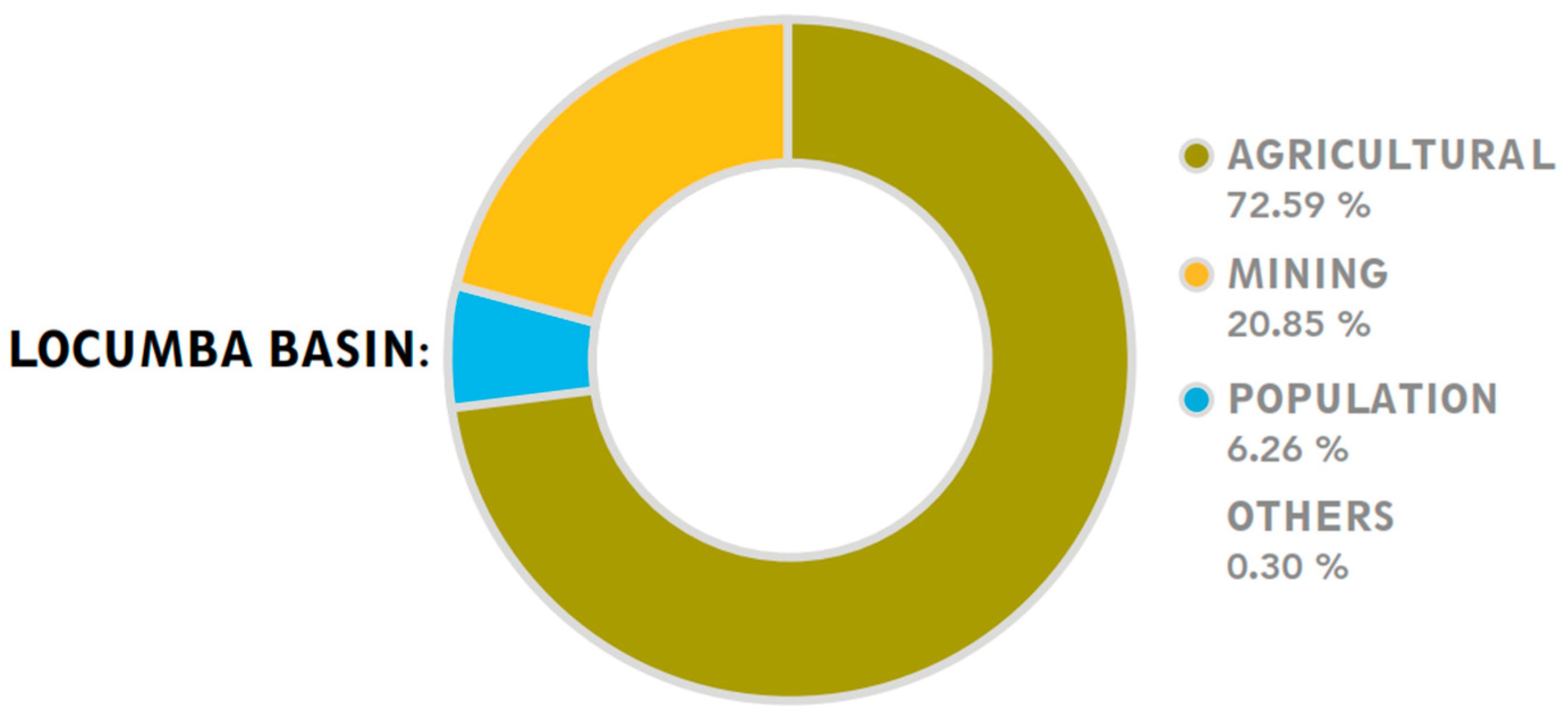
The Locumba basin encompasses hydrogeological units such as aquitards, fissured aquifers, and unconsolidated aquifers (Figure 1). The unconsolidated aquifers are composed of detrital materials, and are distributed in the lower and upper parts of the basin, presenting between a high and medium production. The fissured aquifers are characterized by storing water through geological formations, and these predominate in the upper parts of the basin with a moderate production. The aquitards are located mainly in the central part of the basin, and they are characterized by being poorly permeable with a weak condition to generate aquifers [43]. The Locumba basin surface water comes from several sources: direct runoff, flow subsurface flow, snowmelt, return flow, and underground base flow. These contributions are quantified at gauging stations, allowing the study of water supply. The wet basin, located above 4000 m.a.s.l., generates surface water only in the upper part. The runoff surface water is calculated by adding the flows of the rivers that form the Locumba River, whose runoff measured at the Puente Viejo station is 2694 m3/s, equivalent to 13.33 mm/year. Regarding the use and demand of water, Figure 2 indicates the licenses for water use by different activities in the community of Locumba. There is a clear excessive use of water in agricultural projects, occupying a total of 72.59% of the water consumption surveyed in 2023.

2.2. Hydrogeology

The study area, characterized by a humid basin situated at 3900 m above sea level, contributes significantly to the surface runoff resources originating from the upper region and extending to the Pacific Ocean. In the lower basin, aquifers have been identified on the valley floors, many of which are associated with Quaternary deposits, particularly on the left bank of the Locumba River [43].
It has been observed that the upper region receives the highest concentration of rainfall throughout the year, while precipitation is scarce in the lower region. Additionally, it is important to note the presence of mining tailings discharge. This discharge results from the water used in the industrial processes of the Toquepala and Cuajone mines, which is transported through canals and natural channels [41].
In the Locumba basin, the combined use of surface and groundwater arises as a necessity given the inherent hydrogeological conditions of this area [43]. Similarly, due to its volcanic geology, some tributaries of the upper basin present high concentrations of elements such as arsenic, sulfur, or boron, which force the population of Candarave to combine sources of surface and underground water [44].

3. Materials and Methods

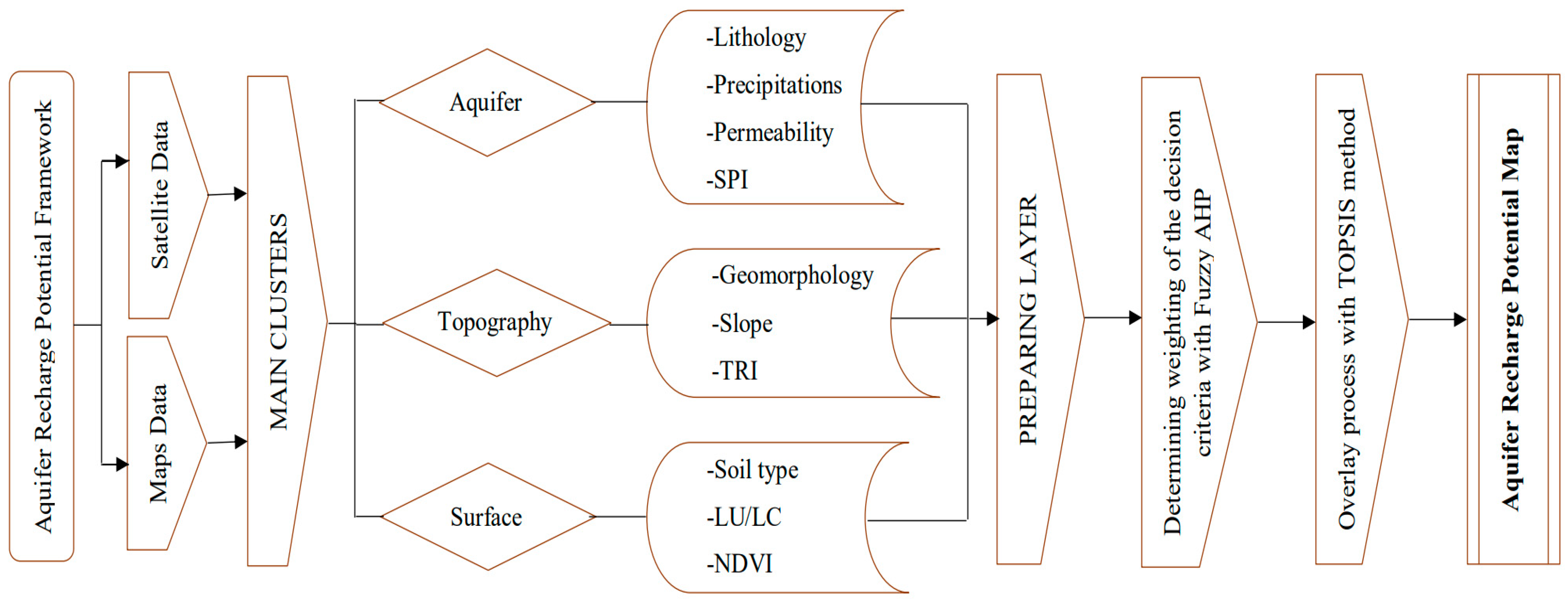
The applied methodology involves the use of two decision-making methods. Firstly, this study proposed using ten decision criteria influencing the recharge potential, which were grouped into the following three clusters: aquifer (lithology, precipitation, permeability, SPI); topography (geomorphology, slope, roughness); and surface (soil type, LU/LC, NDVI). The ten decision criteria were organized in a single format using the WGS84-19S location datum according to the study area. The Fuzzy AHP methodology was first used for calculating the influence of the factors by assigning weights based on expert judgment to the topic addressed. Based on the weights obtained, the TOPSIS methodology was applied, which focuses on classifying the different areas within the basin according to their distance from the ideal positive response, representing the areas with the highest potential, and conversely, the areas of lower potential based on their distance from the ideal negative response. The workflow carried out is detailed in the following methodology diagram (Figure 3).

3.1. Aquifer Recharge Influencing Factors

To obtain the 10 factors, different public access sources were used. Among the data collected for this study are maps and satellite images. The lithology and geomorphology layers were extracted from the downloadable maps of the GEOCATMIN platform developed by the Geological, Mining and Metallurgical Institute (INGEMMET). The soil type layer was obtained from the Ministry of Agriculture (MINAM) portal. The permeability layer was obtained from works published by the National Water Authority (ANA). The slope, roughness, and SPI layers were extracted from Digital Elevation Model (DEM) processing produced by the Shuttle Radar Topography Mission (SRTM), and was accessed in January of 2020. The DEM is a quantitative demonstration of the landscape, and is important for science, hydrological applications, geological analysis, and agricultural land management [45]. The precipitation layer was obtained from the data produced by the Terraclimate remote sensor, and was accessed in January of 2020. The LU/LC layer was obtained from Sentinel-2 10 m Land Use/Land Cover images, and was accessed in January of 2020. The vegetation index layer was obtained from the processing of Landsat-8 images, and was accessed in May of 2024. The product identifiers of each sensor are organized in Table 1. Equally, all layers present their classification regarding the recharge potential presented by each of their classes (Table 2).

3.1.1. Lithology

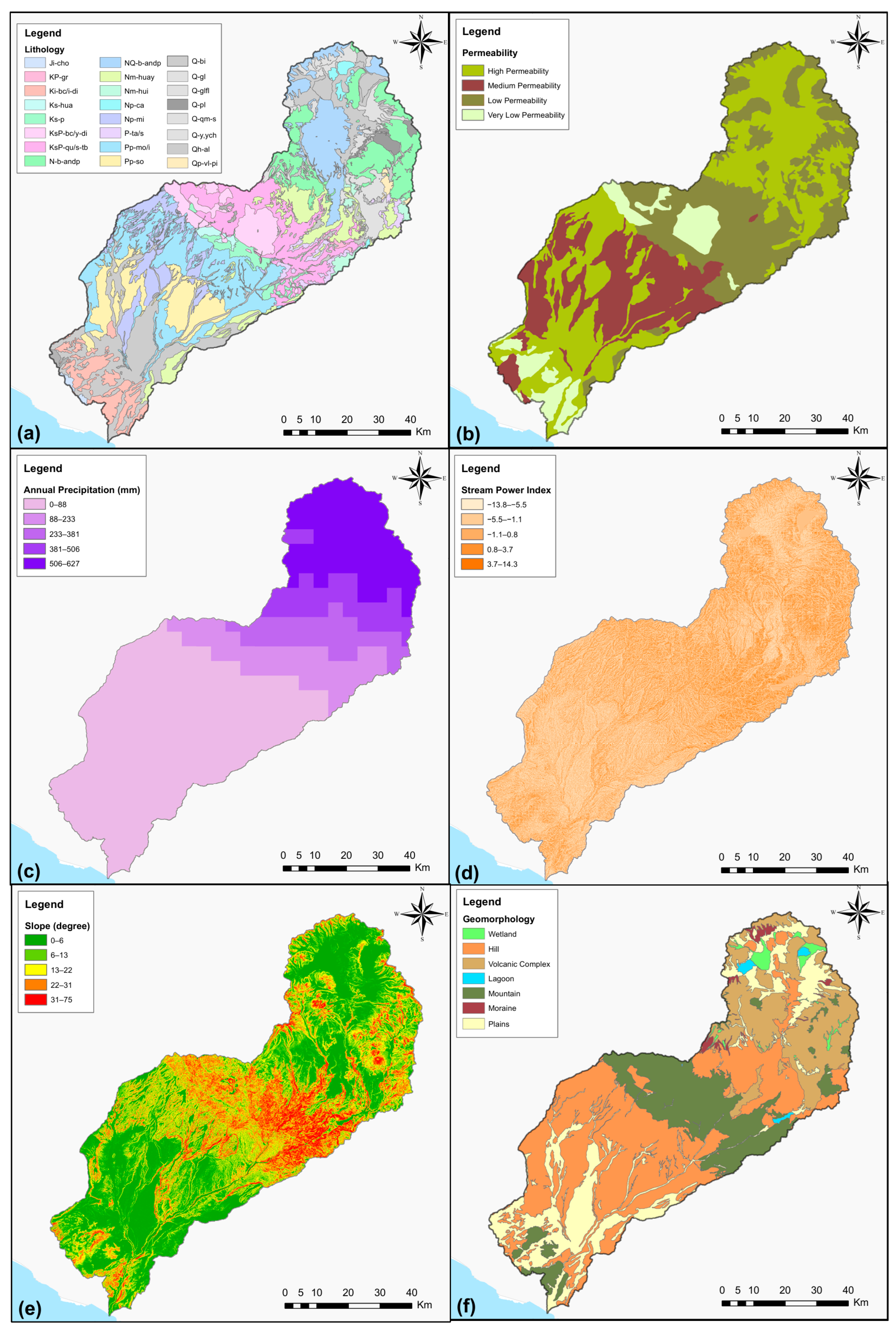
Lithology defines the physical characteristics of the rock that makes up the geological formation, as well as its mineral content, grain size, and packing [46]. The lithological information of the area was obtained from the published works of INGEMMET, accessible from the GEOCATMIN website. At the head of the basin, we find a volcanic environment, with scattered andesite and tuff formations. Likewise, at the head, the presence of glacial and alluvial deposits is observed (Figure 4a). In the middle part of the basin, there is the Andes Mountain range, characterized by large batholiths. To the southwest of the basin, the areas of lower elevations generally present alluvial deposits and formations of a sedimentary nature; at the same time, there is the emplaced coastal batholith. The lithological classification is organized in Table 2.

3.1.2. Permeability

Permeability expresses the extent of the interconnection of the pores. This connection between the pore spaces allows groundwater to flow through the sediment or rock, thus generating a timely recharge potential. The information extracted on permeability was possible thanks to the maps published by the National Water Authority (ANA). The Locumba basin presents zones of very low, low, medium, and high permeability (Figure 4b). The study area mainly presents areas of high permeability, occupying 40% of the total study area, and distributed to the northeast of the basin and above the coastal part of the basin. On the other hand, the most unfavorable areas for hydraulic recharge are the areas of very low and low permeability; these are mainly found in the central areas of the basin and distributed lower to the northeast of the basin. The classification of the permeability layer is organized in Table 2.

3.1.3. Precipitation

Precipitation impacts the hydrological potential of aquifers depending on their values, duration, and intensity [47]. The precipitation information was obtained from the data produced by the Terraclimate sensor, which collects annual information on the water balance globally. The study area presents a range of annual rainfall between 0 mm and 627 mm (Figure 4c). The ranges were classified into five subclasses: very low, low, moderate, high, and very high. The Locumba basin predominantly presents areas with very low rainfall, associated with coastal areas, and these present a progressive increase as one moves towards the northeast, with the greatest range of rainfall found in the areas of highest elevations at the head of the basin. The classification is organized in Table 2.

3.1.4. Stream Power Index

The Stream Power Index (SPI) is an essential factor for groundwater potential studies, as it provides valuable information on the erosion potential of water flow on slopes. It is responsible for quantifying the hydraulic gradient of a slope, which is determined by the volume of water contributed upstream and the water flow [48]. The SPI data were processed from the DEM. The SPI layer presents ranges between −13.8 and 14.3 (Figure 4d), where the lower values represent the most favorable areas for hydraulic recharge. The study area mostly presents low SPI values, occupying a total of 44% of the basin area. The classification of SPI values is organized in Table 2.

3.1.5. Slope

Slope alters the elevation between two locations and has a direct influence on groundwater recharge and infiltration [49]. The slope layer was extracted from the DEM. The Locumba basin presents slopes from 0° to 75° (Figure 4e). The ranges were divided into 5 subclasses: flat from 0° to 6°, soft from 6° to 13°, medium from 13° to 22°, high from 22° to 31°, and very high from 31° to 75°. The slope values indicate that the basin is dominated by high slopes, occupying 31% of the basin area, followed by medium slopes, which occupy 25% of the total area. The classification of slope values is organized in Table 2.

3.1.6. Geomorphology

Geomorphology represents the geographical features and topographical features within a specific region. It is frequently used as a fundamental factor to identify and delimit areas with substantial prospects for the abundance of groundwater resources [50]. The geomorphological information of the area was obtained from the published works of INGEMMET, accessible from the GEOCATMIN platform. The Locumba basin presents geomorphological units from alluvial plains in the coastal pampa, followed by hills and mountains in the center of the basin, and the presence of a volcanic complex together with moraines and small areas of plains located at the head of the basin (Figure 4f). The hills have the largest dimension in the study area, occupying 32% of the total area, followed by the mountains with 19% of the area. The spatial distribution of geomorphology shows a tectonic environment controlled by the emplacement of mountain chains and volcanic complexes. The classification of each type of geomorphology is organized in Table 2.

3.1.7. Topographic Roughness Index

The Topographic Roughness Index (TRI) is commonly used to quantify the degree of undulation present on a given topographic surface. The undulating terrain is a distinctive feature of mountainous areas, where continuous mechanisms of erosion and weathering progressively metamorphose the rugged environment into a smoother, more uniform expanse as time passes [51]. The roughness data were processed from the DEM. The roughness layer presents ranges between 0.11 and 0.88 (Figure 5a), where the highest values represent the most favorable areas for hydraulic recharge. The study area mostly presents average roughness values, occupying a total of 37% of the basin area. The classification of the Topographic Roughness Index is organized in Table 2.

3.1.8. LU/LC

Natural recharge of aquifers is largely controlled by land use and land cover (LU/LC). In this way, the basin is influenced by land use and soil cover for the delimitation of areas with groundwater potential [52]. Land use and land cover (LU/LC) was obtained from the Sentinel-2 Land Use/Land Cover data with a resolution of 10 m. This already developed product is derived from Sentinel-2 images, which were applied to classification models using artificial intelligence, providing a map with 5 classes present within the study area (Figure 5b). The area mainly presents scrub cover, occupying 52% of the total area, closely followed by bare soil occupying 45% of the basin. The land cover of the study area indicates that the Locumba basin is generally not an area exploited by crops, nor predominantly occupied by urban areas. The LU/LC classification is organized in Table 2.

3.1.9. NDVI

The Normalized Difference Vegetation Index (NDVI) indicates a favorable indication of aquifer recharge potential since the NDVI measures the amount of living green vegetation in an area [53]. The NDVI layer was extracted via the processing of Landsat-8 images, obtaining vegetation index ranges between −0.53 and 0.58 (Figure 5c). The Locumba basin presents a small range of considerable vegetation values. The values were divided between 5 subclasses based on the division made by vegetation studies carried out in sectors close to the study area [19], i.e., −0.53–0.1, 0.1–0.25, 0.25–0.37, 0.37–0.42, and 0.42–0.58. The most predominant values are the average ranges of −0.53 to 0.1, which represents bare ground, occupying 96% of the total area of the basin. The vegetation index classification is organized in Table 2.

3.1.10. Soil Type

Soil types have an important impact on the natural recharge of aquifers. The better the soil quality, consisting of high water-holding capacity and porosity, the better the recharge potential [54]. The soil information was obtained from the published works of MINAM, which are accessible for free download. The type of soil is classified by the INAM nomenclature, where FLe-RGe is Eutric Fluvisol-Eutric Regosol, LPd-ANz is Dystric Leptosol-Vitric Andosol, LPd-R is Dystric Leptosol-Lithic outcrop, LPq-R is Lithic Leptosol-Lithic outcrop, and SCh-LPe is haplic Solonchak-Eutric Leptosol (Figure 5d). The predominant soil type is LPd-R, occupying 38% of the basin, followed by LPd-ANz with 28% of the basin area. The classification of soil types is organized in Table 2.

3.2. Fuzzy Analytic Hierarchy Process

The Analytical Hierarchy Process (AHP) was initially proposed by Saaty in 1977 [55]. This method seeks to create a hierarchical structure of various influential factors based on expert criteria. The original AHP methodology is one of the most applied and efficiently implemented decision-making tools in water scarcity studies [56]. Despite this, it presents some limitations related to its limited ability to reflect the inherent ambiguity of the decision-making process that every human being goes through. In this way, Chang 1996 introduced the new Fuzzy AHP approach [57], which works with the fuzzy set theory proposed by Zadeh [58]. This approach seeks to find more appropriate criterion weights since subjective expert opinions using discrete values could lead to less reliable criterion weights [59]. The steps of the Fuzzy AHP approach consisted of the following sequence:
Step 1: Initially, a pairwise comparison matrix was built covering the 10 decision criteria used in this study. To achieve this objective, the experts consulted in this study needed to use linguistic variables based on a scale from 1 to 9 to define the hierarchy between the factors analyzed. Consequently, reciprocals of linguistic variables associated with the degree of importance of each criterion were integrated into the experts’ judgments. In this way, uij, mij, and lij, represent the upper, middle, and lower widths, respectively, of the pairwise judgments made by the experts for criterion i compared to criterion j (Table 3).
Step 2: To evaluate the consistency in the decision-making of the experts surveyed, the value of the Consistency Ratio (CR) was examined. CR expresses the reliability of each decision matrix, where the maximum acceptable value for each decision-making is 0.1. Therefore, if a calculated value of CR exceeds the mentioned threshold value, this indicates that the judgment made by the expert is inconsistent. The CR value is expressed by the following equations:
C I = λ m a x 1 n 1
C R = C I R I
where λmax is the maximum eigenvalue of a matrix, and n is the number of criteria of the corresponding matrix. The values of the Random Index (RI) are detailed in the following table proposed by Saaty (Table 4).
Step 3: The fuzzy equivalents of each linguistic variable used in the matrices are then determined. The following equation represents the calculation of the top (uijk), middle (mijk), and bottom (lijk) widths of the fuzzy equivalents based on the triangular membership function.
    u i j   = k = 1 K u i j 1 K ,       m i j   = k = 1 K m i j 1 K ,       l i j   = k = 1 K l i j 1 K
where k represents each expert, while K represents the total number of experts.
Step 4: In this step, the methodology developed by Chang suggests that each object employs extension analysis for specific objectives. In this way, the fuzzy quantities are obtained through defined mathematical notations, where X represents a set of n (x1, x2. x3, …, xn) and U represents a set of n goals (u1, u2. u3, …, un). The following equation represents the calculation of the fuzzy synthetic extension based on object i:
S i   = j = 1 m M g i j × j = 1 n j = 1 m M g i j 1
where Mgi expresses the triangular fuzzy numbers. Additionally, the degree of possibility is calculated within the fuzzy synthetic extension value, in which M1 (u1, m1, l1) and M2 (u2, m2, l2) are two triangular fuzzy numbers. The degree of possibility is defined by the following equation.
V M 2 M 1 = h t g M 1 M 2 =                                         1                                               i f   m 2 m 1                                         0                                                 i f   l 1 u 2     l 1 u 2 m u 2 ( m 1 l 1 )   o t h e r w i s e
As a final step, the weight vector and the normalized weight vector (W) are calculated, which represent the final decisions of the experts subjected to the study.
W = d A 1 , d A 2 , , d A n T

3.3. Technique for Order of Preference by Similarity to Ideal Solution

The Technique for Order of Preference by Similarity to Ideal Solution (TOPSIS) was initially proposed by Hwang and Yoon in 1981 [60]. TOPSIS consists of an algorithm to deal with MCDM problems based on the execution of an alternative prioritization. This method allows us to determine the best alternative according to its distance from the positive ideal solution (PIS) and the negative ideal solution (NIS). If the geometric distance is the shortest to the PIS, it would obtain a value close to 1, making this an appropriate alternative compared to the others. The sequence of steps of the TOPSIS method is as follows:
Step 1: An evaluation matrix is formulated where m corresponds to a set of alternatives and n corresponds to a set of criteria, expressed within the matrix Aij:
A i j = a 11 a 12 a 1 n a 21 . . a m 1 a 22 . . a m 2 a 2 n . . . . a m n
where Aij represents the importance of alternative i for criterion j.
Step 2: We continue with the normalization of the evaluation matrix Aij. This step ensures that all criteria are given equal weight in the decision-making process by eliminating any scale differences between criteria. The normalization of the matrix is calculated by the following formula:
r i j   = a i j / k = 1 m a k j 2
Step 3: The normalized weighted matrix V is calculated by the following equation:
V = ( v i j ) m × n = ( w j r i j ) m × n
where wj represents the weight of criterion j and i = 1, 2, …, m. The weights of the criteria used in this step are previously calculated using the Fuzzy AHP.
Step 4: Subsequently, the positive ideal solution (PIS) and the negative ideal solution (NIS) are calculated. The PIS symbolizes the alternative that obtains maximum benefit at minimum cost, while the NIS symbolizes the alternative that minimizes benefit and maximizes cost. Represented by A* and A, their calculation is represented by the following equations:
A * = max v i j | j J , max v i j | j J = { v 1 * , v 2 * , , v n * }
A = min v i j | j J , max v i j | j J = { v 1 , v 2 , , v n }
Step 5: The distances of each alternative from A* and A are calculated using the following equations:
d i *   = j = 1 n v i j v j * 2
d i   = j = 1 n v i j v j 2
Step 6: Finally, the closeness coefficient (CCi) is found. This value represents the relative proximity of each alternative with respect to the ideal positive and negative solution, thus ensuring the final prioritization. It is calculated by the following equation:
C C i = d i d i + d i *
where the value of CCi can present a range between 0 and 1, in which the value closest to 1 represents the most appropriate alternative to the ideal positive solution, while the value closest to 0 represents the closest alternative to the ideal negative solution with the recharge potential that exists in the study area.

4. Results

4.1. Multi-Criteria Decision Analysis and Criteria Weighting

Fuzzy AHP is a suitable tool to measure the influence that one factor can have on another. In this study, 10 decision criteria that have a degree of influence concerning the potential for aquifer recharge were evaluated. Firstly, thanks to the contribution of the experts surveyed, the rating of the pairwise factors was organized in a comparison matrix (Table 5) based on three groups of clusters. To evaluate the reliability of the decisions made, the resulting values of the Consistency Ratio (CR) were examined. If a CR result exceeds the cutoff value of 0.1, it symbolizes that the assigned decision-making is inconsistent. The resulting CR values of each cluster showed acceptable values between 0.6 and 0.8.
The results of the weights are organized in Table 6. Evaluating the weights of the three clusters, the cluster with the greatest influence is the aquifer cluster with a weight of 56.66%, followed by the topography cluster with a weight of 31.99%, and that with the lowest degree of influence is the surface cluster, with a weight of 11.35%. Evaluating the local weights (LWs) within the aquifer cluster presents four factors, where precipitation presents the highest degree of influence with a weight of 38.67%, followed by permeability with a weight of 33.26%, lithology with a weight of 20.04%, and Stream Power Index with a weight of 8.03%. Within the topography cluster, the variable that has the greatest weight is slope with 55.07%, followed by geomorphology with 36.3%, and roughness with 8.62%. The local weights within the surface cluster show that NDVI exceeds the other factors with a weight of 54.30%, while it is followed by soil with a weight of 24.81%, and land use/land cover with a weight of 20.89%.
Additionally, there are global weights (GWs), which represent the final degree of contribution of each factor, and which were previously used within the TOPSIS methodological framework. The results show that the factor with the greatest weight is precipitation at 21.91%, closely followed by permeability at 18.85%. It is highlighted that these results present a great relationship with the areas exploited by the residents of Locumba over the years. On the other hand, the factor with the least weight is that of LU/LC, with the lowest value of 2.37%. These results indicate the degree of value among the 10 proposed criteria, which will later be very useful for the evaluation of the recharge potential.
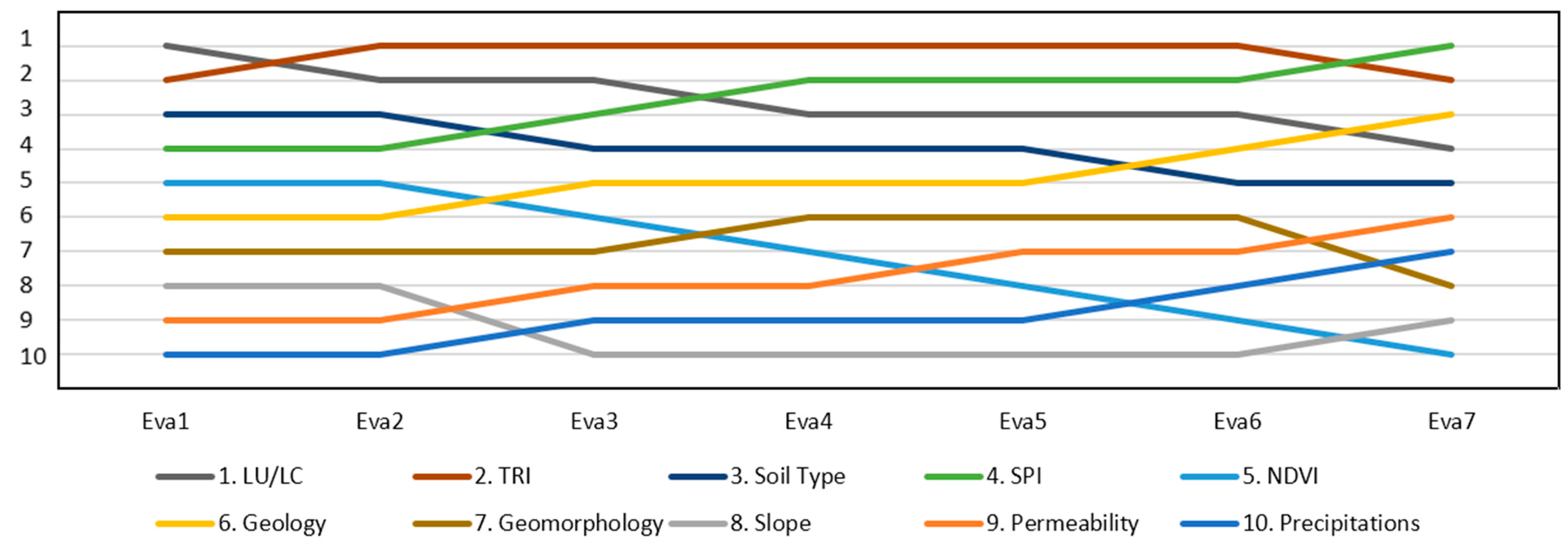
As a final step, to evaluate the stability and robustness of the Fuzzy AHP decision framework, the sensitivity analysis was performed. The sensitivity analysis was applied to the Fuzzy AHP decision framework by varying the weights of the ten factors used, guaranteeing that the hierarchy between the three clusters aquifer > topography > surface remains in force. The result of the analysis used (Figure 6) was applied to a total of seven evaluations, where the variation observed from Evaluation 1 (Eva1) to Evaluation 7 (Eva7) does not show a significant change in the initial ranking. Additionally, the Spearman coefficient was calculated to evaluate the correlation between each ranking found [61,62], where an average value of the seven applied evaluations of 0.739 was obtained, indicating an acceptable correlation. Therefore, according to the sensitivity analysis, it is concluded that the applied decision framework has acceptable reliability.

4.2. Aquifer Recharge Potential Map

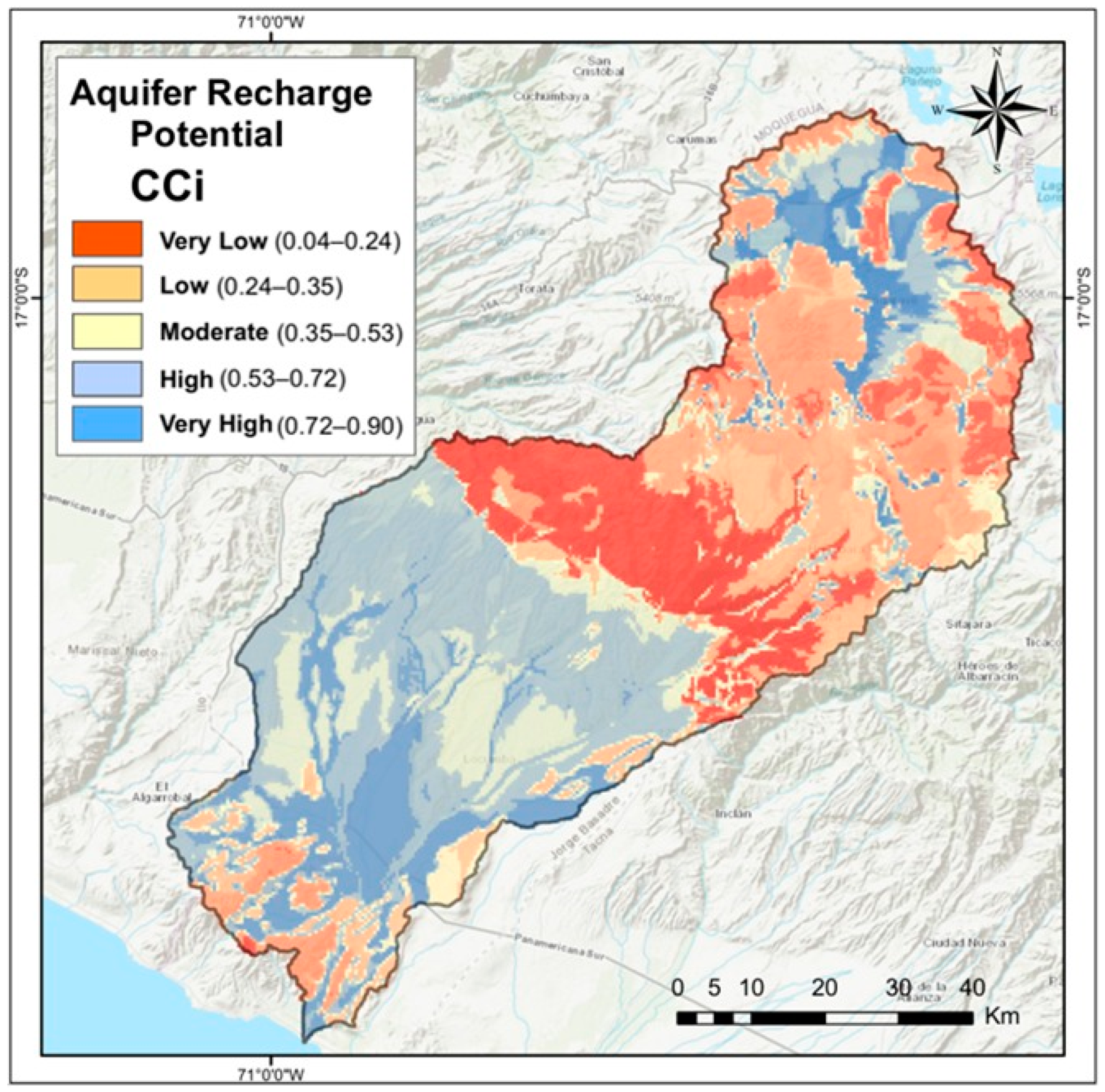
To obtain the aquifer recharge potential in the Locumba basin we rely on the combination of the Fuzzy AHP methodology, which helps us find the weights of the influencing factors, and the Technique for Order of Preference by Similarity to the Ideal Solution (TOPSIS) methodology, which allows us to carry out the final evaluation to determine the most appropriate areas for the response with the highest recharge potential. To evaluate these areas, the TOPSIS algorithm classifies the alternatives according to their closeness coefficient (CCi). The CCi values present a range between 0 and 1, where values close to 0 represent negative ideal solutions, while values close to 1 represent positive ideal solutions, which symbolize the most appropriate areas for our study. In this way, Figure 7 shows the result of the TOPSIS method applied in the Locumba basin. The values ranged from the minimum value of 0.04 to the maximum value of 0.90, which were reclassified into five classes using the Jenks natural break method: very high (0.90–0.72), high (0.72–0.53), moderate (0.53–0.35), low (0.35–0.24), and very low (0.24–0.04).
The results show that the Locumba basin has 10% of areas with a very high aquifer recharge potential, 28% of areas with a high potential, 15% having moderate potential, and 28% and 16% having low and very low potential, respectively. These results indicate that the Locumba basin is not very prone to receiving recharge rates due to its innate hydrological characteristics. The areas with the greatest potential are in the intermediate zone between the coast and the center of the basin, and to the northeast of the basin. These circumstances are possible thanks to the fact that in these areas there are low slopes in combination with a recharge between moderate to very high rainfall. The study area generally presents areas of equally high and low recharge potential, with a small extension of very high recharge potential. This is because the Locumba basin is a region located in an orogenic geological framework that associates areas of high slope, which begin in the middle part of the basin, with non-permeable lithologies that make potential areas of vegetation and soil favorable for the recharge rate impossible. It should be noted that, in the face of a low recharge potential, the adequate management of potential groundwater areas requires constant responsible supervision and management of available water resources.

5. Discussion

The aquifer’s final recharge potential map was created using decision-making methods, leveraging data from remote sensors and maps within a GIS environment. The resulting recharge map indicates an approximately equal distribution of high and low potential zones. The areas with very low recharge potential are mainly concentrated in the central part of the basin. This low potential correlates with regions of high slopes and mountain chains. The lithology in these areas is also not conducive to high recharge, as it consists of intrusive diorite rocks from the geological batholith, which lack porosity and thus limit infiltration capacity. This finding aligns with research conducted by [63] which also highlights that low recharge potential is associated with rock basements. On the other hand, areas with very high recharge capacity are found in the northeast and southwest of the basin, characterized by gentle slopes and significant annual precipitation. Gentle slopes facilitate recharge and high infiltration due to reduced runoff [64]. These regions are also marked by high permeability, associated with Quaternary alluvial deposits. Such sedimentary environments are known for their capacity to store substantial groundwater, particularly when combined with high rainfall distribution [65]. The number of crops and vegetation detected by the processing of Landsat 8 and Sentinel-2 satellite images in high-potential areas do not have a considerable dimension. Furthermore, studies carried out in the Locumba basin highlight that there is inadequate use of low-profitability crops with a high water requirement [41]. In general, among the ten influential factors in the recharge potential of the Locumba basin, precipitation (GW = 0.22), permeability (GW = 0.19), and slope (GW = 0.17) have been determined as having the greatest influence weights on the rest. Previous work in Locumba [40,66] supports these findings, indicating significant aquifer recharge due to the region’s geomorphological configuration, high plateau, and favorable climatic conditions for rain infiltration. Despite this, it is notable to mention that the assessment of the results still represents an ever-present challenge in the face of the inherent ambiguity of the model obtained. The developed model can be further explored by future researchers using alternative methods such as geophysics, hydro-chemical, and isotopic fingerprints studies. Likewise, the integration of advanced machine learning techniques allows for new exploration guidance for future research using algorithms that sharpen the accuracy of predictive models.
The application of the classic AHP method has been widely used in the resolution and management of environmental problems [67,68]. Thus, because of the wide use of the AHP methodology, different alternatives based on the principle of establishing a hierarchical relationship were implemented within the AHP method. This study opted for the use of the Fuzzy AHP alternative, which has its potential in the use of fuzzy set theory to reduce the problem of the complex nature of human decision-making. Furthermore, the use of Fuzzy AHP has been previously successfully employed in the quest to determine potential groundwater zones [69,70]. While MCDM methods aim to mitigate subjectivity and uncertainty, they still face limitations related to subjective judgments and assumptions [71]. However, this study incorporated an additional sensitivity analysis to ensure that the decision-making applied was reliable. The results of the said analysis showed that there is no great variability between the order of importance when making variations in the weights. Additionally, the use of TOPSIS provided an accurate and cost-effective model suitable for large areas, where resource investment may be constrained. The integration of Fuzzy AHP and TOPSIS not only resulted in a robust model based on the optimization of traditional decision-making approaches, but also allowed for flexible evaluation through easy integration and updating of variables that determine recharge potential. Although the use and application of hybrid MCDM methods continue to increase, it is important to consider the limitation of all these studies, which are mainly focused on human decision-making. In large study areas, necessary field studies should always be applied. Despite this, this research provides a contribution to the exploration of suitable aquifer recharge areas, and thus guarantees the conscious use of the vital water resources of the Locumba basin.

6. Conclusions

This research demonstrated that there is ample potential for aquifer recharge in the Locumba basin, despite its arid characteristics presented by the Atacama Desert. The combination of the Fuzzy AHP and TOPSIS methodologies was successful, demonstrating that the optimization of primary methods can be achieved by more rigorous approaches and, likewise, in conjunction with the new remote sensing and GIS technologies, guarantee the proposed estimation of the recharge potential. The study incorporated the use of ten influential factors for the estimation of water resources, where the most essential variables for a successful recharge of a natural aquifer were precipitation, permeability, and slope, which obtained the highest weights of 0.22, 0.19, and 0.17, respectively. The use of this methodology was able to partition the study area into more favorable zones according to their proximity to the ideal response of recharge potential. The result shows a total of 13% for very favorable zones, 28% for favorable zones, 15% for medium areas, 28% for low areas, and 16% for very low areas. The purpose of this study is to promote knowledge of the problem of water scarcity in the Locumba basin, as well as to support better decision-making for the sustainable management of groundwater. The methods applied can be adapted to other basins surrounding this one, in search of obtaining a better matching result, and thus understanding the capacity and potential of the possible aquifers within the arid Atacama Desert.

Author Contributions

Conceptualization, E.P.-V., V.P., P.F.-L. and S.C.; software, V.P., A.M. and E.I.-B.; data curation, S.C.; validation, E.P.-V., P.F.-L., E.I.-B. and G.H.; formal analysis, V.P., A.M., G.H., S.C., P.F.-L., E.I.-B. and E.P.-V.; writing—original draft preparation, V.P., A.M., S.C. and E.P.-V.; writing—review and editing, V.P., G.H., S.C., P.F.-L., E.I.-B. and E.P.-V.; project administration, P.F.-L. and E.P.-V. All authors have read and agreed to the published version of the manuscript.

Funding

This work was financed by funds from the mining royalties, IGIN, VIIN of the UNJBG, within the framework of the research project “Water availability and conservation status of water-dependent ecosystems in the upper basin of the Locumba River”, Resolution of the University Council N° 7747-2020-UN/JBG.

Data Availability Statement

The data that support the findings of this study are available on request from the corresponding author.

Acknowledgments

To the Jorge Basadre Grohmann National University and especially to the H2O’UNJBG Research Group, Water Research Group.

Conflicts of Interest

The authors declare no conflicts of interest.

References

  1. Makonyo, M.; Msabi, M.M. Identification of Groundwater Potential Recharge Zones Using GIS-Based Multi-Criteria Decision Analysis: A Case Study of Semi-Arid Midlands Manyara Fractured Aquifer, North-Eastern Tanzania. Remote Sens. Appl. Soc. Environ. 2021, 23, 100544. [Google Scholar] [CrossRef]
  2. Ifediegwu, S.I. Assessment of Groundwater Potential Zones Using GIS and AHP Techniques: A Case Study of the Lafia District, Nasarawa State, Nigeria. Appl. Water Sci. 2022, 12, 10. [Google Scholar] [CrossRef]
  3. Shandu, I.D.; Atif, I. An Integration of Geospatial Modelling and Machine Learning Techniques for Mapping Groundwater Potential Zones in Nelson Mandela Bay, South Africa. Water 2023, 15, 3447. [Google Scholar] [CrossRef]
  4. Sheikha-BagemGhaleh, S.; Babazadeh, H.; Rezaie, H.; Sarai-Tabrizi, M. The Effect of Climate Change on Surface and Groundwater Resources Using WEAP-MODFLOW Models. Appl. Water Sci. 2023, 13, 121. [Google Scholar] [CrossRef]
  5. Magesh, N.S.; Chandrasekar, N.; Soundranayagam, J.P. Delineation of Groundwater Potential Zones in Theni District, Tamil Nadu, Using Remote Sensing, GIS and MIF Techniques. Geosci. Front. 2012, 3, 189–196. [Google Scholar] [CrossRef]
  6. Houghton, J.T.; Ding, Y.; Griggs, D.J.; Noguer, M.; Van Der Linden, P.J.; Dai, X.; Maskell, K.; Johnson, C.A. Climate Change 2001: The Scientific Basis; Cambridge University Press: Cambridge, UK, 2001. [Google Scholar]
  7. Nafchi, R.F.; Yaghoobi, P.; Vanani, H.R.; Ostad-Ali-Askari, K.; Nouri, J.; Maghsoudlou, B. Correction to: Eco-Hydrologic Stability Zonation of Dams and Power Plants Using the Combined Models of SMCE and CEQUALW2. Appl. Water Sci. 2022, 12, 55. [Google Scholar] [CrossRef]
  8. Naghibi, S.A.; Pourghasemi, H.R.; Pourtaghi, Z.S.; Rezaei, A. Groundwater Qanat Potential Mapping Using Frequency Ratio and Shannon’s Entropy Models in the Moghan Watershed, Iran. Earth Sci. Inform. 2015, 8, 171–186. [Google Scholar] [CrossRef]
  9. Lapworth, D.; Boving, T.; Brauns, B.; Dottridge, J.; Hynds, P.; Kebede, S.; Kreamer, D.; Misstear, B.; Mukherjee, A.; Re, V.; et al. Groundwater Quality: Global Challenges, Emerging Threats and Novel Approaches. Hydrogeol. J. 2023, 31, 15–18. [Google Scholar] [CrossRef]
  10. Pino-Vargas, E.; Espinoza-Molina, J.; Chávarri-Velarde, E.; Quille-Mamani, J.; Ingol-Blanco, E. Impacts of Groundwater Management Policies in the Caplina Aquifer, Atacama Desert. Water 2023, 15, 2610. [Google Scholar] [CrossRef]
  11. Stein, B.A.; Staudt, A.; Cross, M.S.; Dubois, N.S.; Enquist, C.; Griffis, R.; Hansen, L.J.; Hellmann, J.J.; Lawler, J.J.; Nelson, E.J.; et al. Preparing for and Managing Change: Climate Adaptation for Biodiversity and Ecosystems. Front. Ecol. Environ. 2013, 11, 502–510. [Google Scholar] [CrossRef]
  12. Pino, E.; Tacora, P.; Steenken, A.; Alfaro, L.; Valle, A.; Chávarri, E.; Ascencios, D.; Mejía, J. Efecto de Las Características Ambientales y Geológicas Sobre La Calidad Del Agua En La Cuenca Del Río Caplina, Tacna, Perú. Tecnol. Cienc. Agua 2017, 08, 77–99. [Google Scholar] [CrossRef]
  13. Pino, E.; Ramos, L.; Avalos, O.; Tacora, P.; Chávarri, E.; Angulo, O.; Ascensios, D.; Mejía, J. Factores Que Inciden En El Agotamiento y La Contaminación Por Intrusión Marina En El Acuífero Costero de La Yarada, Tacna, Perú. Tecnol. Cienc. Agua 2019, 10, 177–213. [Google Scholar] [CrossRef]
  14. Edwin Pino, V.; Eduardo Chávarri, V.; Lia Ramos, F. Crisis de Gobernanza y Gobernabilidad y Sus Implicancias En El Uso Inadecuado Del Agua Subterránea, Caso Acuífero Costero de La Yarada, Tacna, Perú. Idesia 2018, 36, 77–85. [Google Scholar]
  15. Garreaud, R.; Vuille, M.; Clement, A.C. The Climate of the Altiplano: Observed Current Conditions and Mechanisms of Past Changes. Palaeogeogr. Palaeoclimatol. Palaeoecol. 2003, 194, 5–22. [Google Scholar] [CrossRef]
  16. Garreaud, R.D.; Molina, A.; Farias, M. Andean Uplift, Ocean Cooling and Atacama Hyperaridity: A Climate Modeling Perspective. Earth Planet. Sci. Lett. 2010, 292, 39–50. [Google Scholar] [CrossRef]
  17. Mejia, A. Déficit Hídrico En El Distrito De Locumba—Tacna; Centro de Operaciones de Emergencia Nacional—COEN: Tacna, Peru, 2023.
  18. Edwin Pino, V. Conflictos Por El Uso Del Agua En Una Región Árida: Caso Tacna, Perú. Diálogo Andin. 2021, 65, 405–415. [Google Scholar] [CrossRef]
  19. Pino Vargas, E.M.; Huayna, G. Spatial and Temporal Evolution of Olive Cultivation Due to Pest Attack, Using Remote Sensing and Satellite Image Processing. Sci. Agropecu. 2022, 13, 149–157. [Google Scholar] [CrossRef]
  20. Edwin Pino, V.; Isaac Montalván, D.; Alissa Vera, M.; Lia Ramos, F. La Conductancia Estomática y Su Relación Con La Temperatura Foliar y Humedad Del Suelo En El Cultivo Del Olivo (Olea Europaea L.), En Periodo de Maduración de Frutos, En Zonas Áridas.La Yarada, Tacna, Perú. Idesia 2019, 37, 55–64. [Google Scholar] [CrossRef]
  21. Machaca-Pillaca, R.; Pino-Vargas, E.; Ramos-Fernández, L.; Quille-Mamani, J.; Torres-Rua, A. Estimación de La Evapotranspiración Con Fines de Riego En Tiempo Real de Un Olivar a Partir de Imágenes de Un Drone En Zonas Áridas, Caso La Yarada, Tacna, Perú. Idesia 2022, 40, 55–65. [Google Scholar] [CrossRef]
  22. Quille-Mamani, J.A.; Huayna, G.; Pino-Vargas, E.; Chucuya-Mamani, S.; Vera-Barrios, B.; Ramos-Fernandez, L.; Espinoza-Molina, J.; Cabrera-Olivera, F. Spatio-Temporal Evolution of Olive Tree Water Status Using Land Surface Temperature and Vegetation Indices Derived from Landsat 5 and 8 Satellite Imagery in Southern Perú. Agriculture 2024, 14, 662. [Google Scholar] [CrossRef]
  23. Vera, A.; Pino-Vargas, E.; Verma, M.P.; Chucuya, S.; Chávarri, E.; Canales, M.; Torres-Martínez, J.A.; Mora, A.; Mahlknecht, J. Hydrodynamics, Hydrochemistry, and Stable Isotope Geochemistry to Assess Temporal Behavior of Seawater Intrusion in the La Yarada Aquifer in the Vicinity of Atacama Desert, Tacna, Perú. Water 2021, 13, 3161. [Google Scholar] [CrossRef]
  24. Chucuya, S.; Vera, A.; Pino-Vargas, E.; Steenken, A.; Mahlknecht, J.; Montalván, I. Hydrogeochemical Characterization and Identification of Factors Influencing Groundwater Quality in Coastal Aquifers, Case: La Yarada, Tacna, Perú. Int. J. Environ. Res. Public Health 2022, 19, 2815. [Google Scholar] [CrossRef] [PubMed]
  25. Lanchipa-Ale, T.; Cruz-Baltuano, A.; Molero-Yañez, N.; Chucuya, S.; Vera-Barrios, B.; Pino-Vargas, E. Assessment of Greywater Reuse in a University Building in a Hyper-Arid Region: Quantity, Quality, and Social Acceptance. Sustainability 2024, 16, 3088. [Google Scholar] [CrossRef]
  26. Edwin Pino, V. El Acuífero Costero La Yarada, Después de 100 Años de Explotación Como Sustento de Una Agricultura En Zonas Áridas: Una Revisión Histórica. Idesia 2019, 37, 39–45. [Google Scholar] [CrossRef]
  27. Edwin Pino, V.; Lia Ramos, F.; Jesús Mejía, M.; Eduardo Chávarri, V.; David Ascensios, T. Medidas de Mitigación Para El Acuífero Costero La Yarada, Un Sistema Sobreexplotado En Zonas Áridas. Idesia 2020, 38, 21–31. [Google Scholar] [CrossRef]
  28. Narvaez-Montoya, C.; Torres-Martínez, J.A.; Pino-Vargas, E.; Cabrera-Olivera, F.; Loge, F.J.; Mahlknecht, J. Predicting Adverse Scenarios for a Transboundary Coastal Aquifer System in the Atacama Desert (Perú/Chile). Sci. Total Environ. 2022, 806, 150386. [Google Scholar] [CrossRef]
  29. Ekmekcioğlu, Ö.; Koc, K.; Özger, M. Stakeholder Perceptions in Flood Risk Assessment: A Hybrid Fuzzy AHP-TOPSIS Approach for Istanbul, Turkey. Int. J. Disaster Risk Reduct. 2021, 60, 102327. [Google Scholar] [CrossRef]
  30. Koc, K.; Ekmekcioğlu, Ö.; Özger, M. An Integrated Framework for the Comprehensive Evaluation of Low Impact Development Strategies. J. Environ. Manag. 2021, 294, 113023. [Google Scholar] [CrossRef] [PubMed]
  31. Mohamed Mouhoumed, R.; Ekmekcioğlu, Ö.; Özger, M. A Hybrid MCDA Approach for Delineating Sites Suitable for Artificial Groundwater Recharge Using Drywells. J. Hydrol. 2023, 620, 129387. [Google Scholar] [CrossRef]
  32. Mouhoumed, R.M.; Ekmekcioğlu, Ö.; Başakın, E.E.; Özger, M. Integrated Fuzzy AHP-TOPSIS Model for Assessing Managed Aquifer Recharge Potential in a Hot Dry Region: A Case Study of Djibouti at a Country Scale. Water 2023, 15, 2534. [Google Scholar] [CrossRef]
  33. Saaty, T.L. Axiomatic Foundation of the Analytic Hierarchy Process. Manag. Sci. 1986, 32, 841–855. [Google Scholar] [CrossRef]
  34. Saaty, T.L. What Is the Analytic Hierarchy Process? In Mathematical Models for Decision Support; Springer: Berlin/Heidelberg, Germany, 1988; pp. 109–121. [Google Scholar]
  35. Liu, Y.; Eckert, C.M.; Earl, C. A Review of Fuzzy AHP Methods for Decision-Making with Subjective Judgements. Expert Syst. Appl. 2020, 161, 113738. [Google Scholar] [CrossRef]
  36. Önüt, S.; Soner, S. Transshipment Site Selection Using the AHP and TOPSIS Approaches under Fuzzy Environment. Waste Manag. 2008, 28, 1552–1559. [Google Scholar] [CrossRef] [PubMed]
  37. Siabi, E.K.; Dile, Y.T.; Kabo-Bah, A.T.; Amo-Boateng, M.; Anornu, G.K.; Akpoti, K.; Vuu, C.; Donkor, P.; Mensah, S.K.; Incoom, A.B.M.; et al. Machine Learning Based Groundwater Prediction in a Data-Scarce Basin of Ghana. Appl. Artif. Intell. 2022, 36, 2138130. [Google Scholar] [CrossRef]
  38. Israil, M.; Al-hadithi, M.; Singhal, D.C. Application of a Resistivity Survey and Geographical Information System (GIS) Analysis for Hydrogeological Zoning of a Piedmont Area, Himalayan Foothill Region, India. Hydrogeol. J. 2006, 14, 753–759. [Google Scholar] [CrossRef]
  39. Singh, L.K.; Jha, M.K.; Chowdary, V.M. Multi-Criteria Analysis and GIS Modeling for Identifying Prospective Water Harvesting and Artificial Recharge Sites for Sustainable Water Supply. J. Clean. Prod. 2017, 142, 1436–1456. [Google Scholar] [CrossRef]
  40. Chávarri, E.; Pino, E.; Espíritu, G.; Gonzales, J.; Villanueva, E. Evaluación de Recursos Hídricos Cuencas de Los Ríos Locumba y Sama; Autoridad Nacional del Agua—ANA: Tacna, Peru, 2010. [Google Scholar]
  41. Rosazza, E. Plan de Gestión de Los Recursos Hídricos de La Cuenca Caplina—Locumba; Autoridad Nacional del Agua—ANA: Tacna, Peru, 2013. [Google Scholar]
  42. Lazarow, N.; Hopkins, R.; Peña-Arancibia, J.; Chiew, F.; Tapsuwan, S.; Zheng, H.; Penton, D.; Rojas, R.; Rocha, A.G.; Albisetti, M.; et al. Desarrollo De Un Plan De Gestión De Sequías Para Una Cuenca Árida Altamente Regulada Con Usuarios Multisectoriales Caplina Locumba, Tacna, Peru; Commonwealth Scientific and Industrial Research Organisation—CSIRO: Tacna, Peru, 2018. [Google Scholar]
  43. Cotrina, G.; Olarte, Y.; Peña, F. Hidrogeología de La Cuenca Del Río Locumba—Región Tacna—[Boletín H 2]; Instituto Geológico, Minero y Metalúrgico—INGEMMET: Lima, Peru, 2009.
  44. Geng, D. Implementando Desigualdades: Reprodução de Desigualdades Na Implementação de Políticas Públicas; Instituto de Pesquisa Econômica Aplicada: Rio de Janeiro, Brazil, 2019.
  45. Moura-Bueno, J.M.; Dalmolin, R.S.D.; ten Caten, A.; Ruiz, L.F.C.; Ramos, P.V.; Dotto, A.C. Assessment of Digital Elevation Model for Digital Soil Mapping in a Watershed with Gently Undulating Topography. Rev. Bras. Ciência Solo 2016, 40, e0150022. [Google Scholar] [CrossRef]
  46. Freeze, R.A.; Cherry, J. Groundwater; Prentice-Hall: Hoboken, NJ, USA, 1979. [Google Scholar]
  47. Patra, S.; Mishra, P.; Mahapatra, S.C. Delineation of Groundwater Potential Zone for Sustainable Development: A Case Study from Ganga Alluvial Plain Covering Hooghly District of India Using Remote Sensing, Geographic Information System and Analytic Hierarchy Process. J. Clean. Prod. 2018, 172, 2485–2502. [Google Scholar] [CrossRef]
  48. Ikirri, M.; Boutaleb, S.; Ibraheem, I.M.; Abioui, M.; Echogdali, F.Z.; Abdelrahman, K.; Id-Belqas, M.; Abu-Alam, T.; El Ayady, H.; Essoussi, S.; et al. Delineation of Groundwater Potential Area Using an AHP, Remote Sensing, and GIS Techniques in the Ifni Basin, Western Anti-Atlas, Morocco. Water 2023, 15, 1436. [Google Scholar] [CrossRef]
  49. Grinevskii, S.O. The Effect of Topography on the Formation of Groundwater Recharge. Moscow Univ. Geol. Bull. 2014, 69, 47–52. [Google Scholar] [CrossRef]
  50. Nadiri, A.A.; Sedghi, Z.; Khatibi, R.; Gharekhani, M. Mapping Vulnerability of Multiple Aquifers Using Multiple Models and Fuzzy Logic to Objectively Derive Model Structures. Sci. Total Environ. 2017, 593–594, 75–90. [Google Scholar] [CrossRef] [PubMed]
  51. Prapanchan, V.N.; Subramani, T.; Karunanidhi, D. GIS and Fuzzy Analytical Hierarchy Process to Delineate Groundwater Potential Zones in Southern Parts of India. Groundw. Sustain. Dev. 2024, 25, 101110. [Google Scholar] [CrossRef]
  52. Ahmed, A.A.; Shabana, A.R. Integrating of Remote Sensing, GIS and Geophysical Data for Recharge Potentiality Evaluation in Wadi El Tarfa, Eastern Desert, Egypt. J. African Earth Sci. 2020, 172, 103957. [Google Scholar] [CrossRef]
  53. Helbich, M. Spatiotemporal Contextual Uncertainties in Green Space Exposure Measures: Exploring a Time Series of the Normalized Difference Vegetation Indices. Int. J. Environ. Res. Public Health 2019, 16, 852. [Google Scholar] [CrossRef] [PubMed]
  54. Xu, G.; Su, X.; Zhang, Y.; You, B. Identifying Potential Sites for Artificial Recharge in the Plain Area of the Daqing River Catchment Using GIS-Based Multi-Criteria Analysis. Sustainability 2021, 13, 3978. [Google Scholar] [CrossRef]
  55. Saaty, T.L. A Scaling Method for Priorities in Hierarchical Structures. J. Math. Psychol. 1977, 15, 234–281. [Google Scholar] [CrossRef]
  56. Pocco, V.; Chucuya, S.; Huayna, G.; Ingol-Blanco, E.; Pino-Vargas, E. A Multi-Criteria Decision-Making Technique Using Remote Sensors to Evaluate the Potential of Groundwater in the Arid Zone Basin of the Atacama Desert. Water 2023, 15, 1344. [Google Scholar] [CrossRef]
  57. Chang, D.-Y. Applications of the Extent Analysis Method on Fuzzy AHP. Eur. J. Oper. Res. 1996, 95, 649–655. [Google Scholar] [CrossRef]
  58. Zadeh, L.A. Fuzzy Sets. Inf. Control 1965, 8, 338–353. [Google Scholar] [CrossRef]
  59. Vahidnia, M.H.; Alesheikh, A.A.; Alimohammadi, A. Hospital Site Selection Using Fuzzy AHP and Its Derivatives. J. Environ. Manage. 2009, 90, 3048–3056. [Google Scholar] [CrossRef]
  60. Hwang, C.-L.; Yoon, K. Multiple Attribute Decision Making; Springer: Berlin/Heidelberg, Germany, 1981; Volume 186. [Google Scholar]
  61. Chatterjee, K.; Pamucar, D.; Zavadskas, E.K. Evaluating the Performance of Suppliers Based on Using the R’AMATEL-MAIRCA Method for Green Supply Chain Implementation in Electronics Industry. J. Clean. Prod. 2018, 184, 101–129. [Google Scholar] [CrossRef]
  62. Ahmad, N.; Qahmash, A. Implementing Fuzzy AHP and FUCOM to Evaluate Critical Success Factors for Sustained Academic Quality Assurance and ABET Accreditation. PLoS ONE 2020, 15, e0239140. [Google Scholar] [CrossRef] [PubMed]
  63. Ki, I.; Chakroun, H.; Koussoube, Y.; Zouari, K. Assessment of Aquifer Recharge Potential Using Remote Sensing, GIS and the Analytical Hierarchy Process (AHP) Combined with Hydrochemical and Isotope Data (Tamassari Basin, Burkina Faso). Water 2023, 15, 650. [Google Scholar] [CrossRef]
  64. Aluko, O.E.; Igwe, O. An Integrated Geomatics Approach to Groundwater Potential Delineation in the Akoko-Edo Area, Nigeria. Environ. Earth Sci. 2017, 76, 240. [Google Scholar] [CrossRef]
  65. Mengistu, T.D.; Chang, S.W.; Kim, I.-H.; Kim, M.-G.; Chung, I.-M. Determination of Potential Aquifer Recharge Zones Using Geospatial Techniques for Proxy Data of Gilgel Gibe Catchment, Ethiopia. Water 2022, 14, 1362. [Google Scholar] [CrossRef]
  66. Chávarri, E.; Rodríguez, E.; Vásquez, F.; Zumarán, C.; Suarez, W. Estudio de Los Recursos Hídricos Superficiales y Subterráneos e Infraestructura Hidraúlica Para El Aprovechamiento En La Cuenca Del Río Locumba, En La Región de Tacna; Autoridad Nacional del Agua—ANA: Tacna, Peru, 2017. [Google Scholar]
  67. Kazakis, N. Delineation of Suitable Zones for the Application of Managed Aquifer Recharge (MAR) in Coastal Aquifers Using Quantitative Parameters and the Analytical Hierarchy Process. Water 2018, 10, 804. [Google Scholar] [CrossRef]
  68. Khan, M.Y.A.; ElKashouty, M.; Zaidi, F.K.; Egbueri, J.C. Mapping Aquifer Recharge Potential Zones (ARPZ) Using Integrated Geospatial and Analytic Hierarchy Process (AHP) in an Arid Region of Saudi Arabia. Remote Sens. 2023, 15, 2567. [Google Scholar] [CrossRef]
  69. Mallick, J.; Khan, R.A.; Ahmed, M.; Alqadhi, S.D.; Alsubih, M.; Falqi, I.; Hasan, M.A. Modeling Groundwater Potential Zone in a Semi-Arid Region of Aseer Using Fuzzy-AHP and Geoinformation Techniques. Water 2019, 11, 2656. [Google Scholar] [CrossRef]
  70. Papadopoulos, C.; Spiliotis, M.; Pliakas, F.; Gkiougkis, I.; Kazakis, N.; Papadopoulos, B. Hybrid Fuzzy Multi-Criteria Analysis for Selecting Discrete Preferable Groundwater Recharge Sites. Water 2022, 14, 107. [Google Scholar] [CrossRef]
  71. Sahoo, S.K.; Goswami, S.S. A Comprehensive Review of Multiple Criteria Decision-Making (MCDM) Methods: Advancements, Applications, and Future Directions. Decis. Mak. Adv. 2023, 1, 25–48. [Google Scholar] [CrossRef]
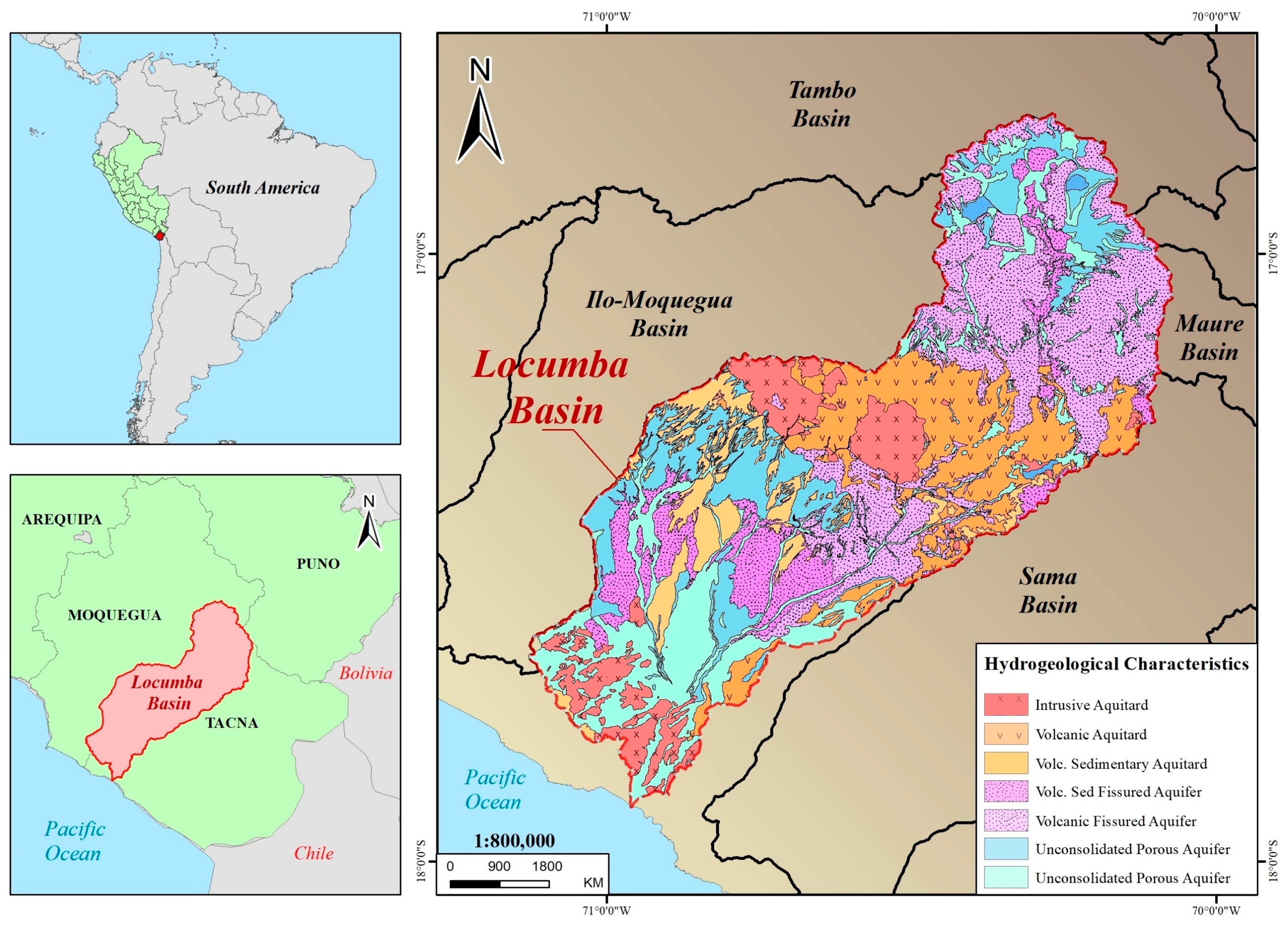
Figure 1. Hydrogeological characteristics of the study area.
Water 16 02643 g001
Figure 2. Water use licenses in the Locumba basin. Modified from the National Water Authority (ANA).
Water 16 02643 g002
Figure 3. Methodology flowchart of the aquifer recharge potential mapping.
Water 16 02643 g003
Figure 4. Factors maps for Fuzzy AHP: (a) lithology, (b) permeability, (c) precipitations, (d) SPI, (e) slope, and (f) geomorphology.
Water 16 02643 g004
Figure 5. Factor maps for Fuzzy AHP: (a) TRI, (b) LU/LC, (c) NDVI, and (d) soil type.
Water 16 02643 g005
Figure 6. Sensitivity analysis for seven evaluations (Eva) of the Fuzzy AHP ranking.
Water 16 02643 g006
Figure 7. Aquifer recharge potential map of the Locumba basin.
Water 16 02643 g007
Table 1. Product identifier of each sensor.
DataYearProduct Identifier
SRTM2000’NASA/NASADEM_HGT/001’ 2000-02-11T00:00:00–
2000-02-22T00:00:00
Sentinel-2 10 m Land use/Land cover2020’projects/sat-io/open-datasets/landcover/ESRI_Global-LULC_10m’
Terraclimate2020IDAHO_EPSCOR/TERRACLIMATE/202001
IDAHO_EPSCOR/TERRACLIMATE/202002
IDAHO_EPSCOR/TERRACLIMATE/202003
IDAHO_EPSCOR/TERRACLIMATE/202004
IDAHO_EPSCOR/TERRACLIMATE/202005
IDAHO_EPSCOR/TERRACLIMATE/202006
IDAHO_EPSCOR/TERRACLIMATE/202007
IDAHO_EPSCOR/TERRACLIMATE/202008
IDAHO_EPSCOR/TERRACLIMATE/202009
IDAHO_EPSCOR/TERRACLIMATE/2020010
IDAHO_EPSCOR/TERRACLIMATE/2020011
IDAHO_EPSCOR/TERRACLIMATE/2020012
Landsat-82024LANDSAT/LC08/C02/T1_L2/LC08_002072_20240330
LANDSAT/LC08/C02/T1_L2/LC08_002073_20240204
Table 2. Rating of the decision criteria for each class.
ClusterCriteriaClassesRating
AquiferLithologyAlluvial Sediment5
Fluvio-glacial Deposits3
Intrusive Rocks1
Sedimentary Rocks4
Volcanic Rocks1
Sedimentary Volcano2
PermeabilityHigh Permeability4
Medium Permeability3
Low Permeability2
Very Low Permeability1
Precipitation0–88.51
88.5–233.52
233.5–381.13
381.1–506.54
506.5–6275
SPI−13.8–−5.35
−5.3–−1.14
−1.1–0.83
0.8–3.72
3.7–14.31
TopographySlope0–65
6–134
13–223
22–312
31–751
GeomorphologyWetland4
Hill3
Complex Volcano2
Lagoon1
Mountains1
Moraine4
Plains5
TRI0.11–0.381
0.38–0.462
0.46–0.533
0.53–0.614
0.61–0.885
SurfaceLULCWater Bodies1
Crops5
Shrubs3
Urban Zone2
Bare Soil1
NDVI−0.53–11
0.1–0.252
0.25–0.373
0.37–0.424
0.42–0.585
Soil TypeFLe- RGe3
LPd-ANz2
LPd-R4
LPq-R1
SCh-LPe5
Table 3. Linguistic scale and triangular fuzzy reciprocals of Fuzzy AHP.
Linguistic VariablesImportance Triangular   Fuzzy   Numbers   ( l i j , m i j , u i j ) Triangular   Fuzzy   Reciprocals   ( 1 / u i j , 1 / m i j , 1 / l i j )
Equally import1(1,1,1)(1,1,1)
Intermediate value2(1,2,3)(1/3,1/2,1)
Moderately important3(2,3,4)(1/4,1/3,1/2)
Intermediate value4(3,4,5)(1/5,1/4,1/3)
Important5(4,5,6)(1/6,1/5,1/4)
Intermediate value6(5,6,7)(1/7,1/6,1/5)
Very important7(6,7,8)(1/8,1/7,1/6)
Intermediate value8(7,8,9)(1/9,1/8,1/7)
Extremely important9(9,9,9)(1/9,1/9,1/9)
Table 4. Random Index.
N12345678910
RI000.520.891.111.251.351.401.451.49
Table 5. Pairwise comparison matrix of each cluster.
CLUSTERSAquiferTopographySurface
Aquifer(1,1,1)(1,2,3)(3,4,5)
Topography(1/3,1/2,1)(1,1,1)(2,3,4)
Surface(1/5,1/4,1/3)(1/4,1/3,1/2)(1,1,1)
C1: AQUIFERLithologyPermeabilityPrecipitationSPI
Lithology(1,1,1)(1/4,1/3,1/2)(1/3,1/2,1)(3,4,5)
Permeability(2,3,4)(1,1,1)(1,1,1)(4,5,6)
Precipitation(1,2,3)(1,1,1)(1,1,1)(5,6,7)
SPI(1/5,1/4,1/3)(1/6,1/5,1/4)(1/7,1/6,1/5)(1,1,1)
C2: TOPOGRAPHYSlopeGeomorphologyRoughness
Slope(1,1,1)(1,1,1)(5,6,7)
Geomorphology(1/3,1/2,1)(1,1,1)(4,5,6)
Roughness(1/7,1/6,1/5)(1/6, 1/5,1/4)(1,1,1)
C3: SURFACELULCNDVISoil
LULC(1,1,1)(1/4,1/3,1/2)(1,1,1)
NDVI(2,3,4)(1,1,1)(1,2,3)
Soil(1,1,1)(1/3,1/2,1)(1,1,1)
Table 6. Decision criteria weight and their respective ranking.
ClusterWeightCriteriaL.W.G.W.Rank
Aquifer0.5666Lithology0.20040.11355
Permeability0.33260.18852
Precipitation0.38670.21911
SPI0.08030.04557
Topography0.3199Slope0.55070.17623
Geomorphology0.36320.11624
Roughness0.08620.02769
Surface0.1135LULC0.20890.023710
NDVI0.54300.06176
Soil0.24810.02828
Disclaimer/Publisher’s Note: The statements, opinions and data contained in all publications are solely those of the individual author(s) and contributor(s) and not of MDPI and/or the editor(s). MDPI and/or the editor(s) disclaim responsibility for any injury to people or property resulting from any ideas, methods, instructions or products referred to in the content.