Article

Natural Water Sources and Small-Scale Non-Artisanal Andesite Mining: Scenario Analysis of Post-Mining Land Interventions Using System Dynamics

by
Mohamad Khusaini
1,2,
Rita Parmawati
1,3,*,†,
Corinthias P. M. Sianipar
4,5,*,†,
Gatot Ciptadi
1,6 and
Satoshi Hoshino
7,8
1
Postgraduate School, Brawijaya University, Malang 65145, Indonesia
2
Faculty of Economics and Business, Brawijaya University, Malang 65300, Indonesia
3
Faculty of Agriculture, Brawijaya University, Malang 65145, Indonesia
4
Department of Global Ecology, Kyoto University, Kyoto 606-8501, Japan
5
Division of Environmental Science and Technology, Kyoto University, Kyoto 606-8502, Japan
6
Faculty of Animal Sciences, Brawijaya University, Malang 65145, Indonesia
7
Graduate School of Global Environmental Studies, Kyoto University, Kyoto 606-8501, Japan
8
Graduate School of Agriculture, Kyoto University, Kyoto 606-8502, Japan
*
Authors to whom correspondence should be addressed.
These authors contributed equally to this work.
Water 2024, 16(17), 2536; https://doi.org/10.3390/w16172536
Submission received: 22 April 2024 / Revised: 8 August 2024 / Accepted: 23 August 2024 / Published: 7 September 2024
(This article belongs to the Section Hydrogeology)

Abstract

:
Small-scale open-pit, non-artisanal mining of low-value ores is an understudied practice despite its widespread occurrence and potential impact on freshwater resources due to mining-induced land-use/cover changes (LUCCs). This research investigates the long-term impacts of andesite mining in Pasuruan, Indonesia, on the Umbulan Spring’s water discharge within its watershed. System Dynamics (SD) modeling captures the systemic and systematic impact of mining-induced LUCCs on discharge volumes and groundwater recharge. Agricultural and reservoir-based land reclamation scenarios then reveal post-mining temporal dynamics. The no-mining scenario sees the spring’s discharge consistently decrease until an inflection point in 2032. With mining expansion, reductions accelerate by ~1.44 million tons over two decades, or 65.31 thousand tons annually. LUCCs also decrease groundwater recharge by ~2.48 million tons via increased surface runoff. Proposed post-mining land interventions over reclaimed mining areas influence water volumes differently. Reservoirs on reclaimed land lead to ~822.14 million extra tons of discharge, 2.75 times higher than the agricultural scenario. Moreover, reservoirs can restore original recharge levels by 2039, while agriculture only reduces the mining impact by 28.64% on average. These findings reveal that small-scale non-artisanal andesite mining can disrupt regional hydrology despite modest operating scales. Thus, evidence-based guidelines are needed for permitting such mines based on environmental risk and site water budgets. Policy options include discharge or aquifer recharge caps tailored to small-scale andesite mines. The varied outputs of rehabilitation scenarios also highlight evaluating combined land and water management interventions. With agriculture alone proving insufficient, optimized mixes of revegetation and water harvesting require further exploration.

1. Introduction

Water and land are two essential natural resources that form the foundation of human society and ecological sustainability. The interactions between water sources and land-use practices reflect an interdependent relationship, creating the water–land nexus [1]. Water follows a hydrological cycle, continuously flowing between the atmosphere, land surface, and underground. Moving through these different compartments influenced by land cover, topography, and other geological characteristics, water affects the structure and texture of the soil and shapes its physical and chemical properties [2]. Meanwhile, land-use practices, driven by anthropogenic activities such as agriculture, residential, and industrial development, can significantly impact water resource quantity, quality, and distribution [3]. These land-use/cover changes (LUCCs) can also have cascading effects on the ecosystem services provided by water and land resources. However, competing demands for water and land resources in different sectors can lead to conflicts and inequitable distribution [4,5]. As populations grow and development accelerates globally, balancing water–land needs for residential, industrial, and agricultural uses while sustaining ecological flows poses an increasing challenge for communities and policymakers. Thus, long-term assessment of the water–land nexus is critical to developing practices and policies that promote more sustainable and equitable water and land resources while supporting human well-being and socioeconomic development.
Among industrial sectors, the mining industry is known for its intensive use of water and land resources [6], making the water–land nexus crucial in running its industrial operations. In many cases, groundwater resources are an attractive option for the mining industry due to their stable and consistent water supply throughout the year [7]. However, when the groundwater extraction rate exceeds the recharge rate of the aquifer, it can result in the depletion of groundwater resources over time [8]. This depletion can have far-reaching impacts on the surrounding ecosystems, affecting the availability of water for both human and ecological needs. In addition to the impacts on water resources, the mining industry is also recognized as a significant driver of LUCCs [9], particularly in the case of surface mining operations. Open-pit mining activities often involve the clearing of large areas of land, the removal of topsoil and vegetation, and the alteration of natural landforms. These LUCCs can have significant implications for the hydrological cycle [10], as they can alter the ability of the soil to absorb and retain water. The removal of vegetation and soil compaction can lead to increased surface runoff and reduced water infiltration into the ground, thereby reducing the recharge of groundwater aquifers.
The water–land nexus in large-scale mining operations has been extensively studied. However, the interplay between groundwater recharge and LUCC patterns in small-scale open-pit, non-artisanal mining has received comparatively little attention and analysis. This is likely because water use and LUCCs in small-scale mining are presumably negligible compared to those in large-scale mining activities [11]. Most existing research on the water–land nexus in the small-scale mining sector has focused on high-value minerals such as gold, gemstones, or other vital metals [12,13]. For mining operations on low-value ores, water and land uses have not been deemed a priority for in-depth study. Still, even limited LUCCs driven and modest amounts of water drawn by small-scale open-pit, non-artisanal mining from water sources could have socio-ecological impacts over time. This highlights the need to investigate the spatiotemporal relationships between LUCC patterns induced by small-scale open-pit, non-artisanal mining and the recharge of groundwater resources. While the water use of small-scale operations might be low, the long-term impacts of LUCCs could be significant, particularly for those dependent on shared water sources [14]. Careful analysis of these cumulative impacts can inform policies and regulations to balance the LUCC patterns of small-scale miners and nearby communities relying on common water resources [15].
Thus, this study addresses this gap by observing the LUCCs driven by small-scale open-pit, non-artisanal mining operations of low-value ores and the subsequent impacts on nearby natural water sources. Since their LUCC patterns change over time [16], this study utilizes dynamic modeling to capture temporal variations in the impact on water discharge. Moreover, since post-mining land treatment decisions can also affect groundwater system recovery [17], the investigation examines discharge trajectories under different reclamation scenarios. Although the economic outputs from small-scale open-pit, non-artisanal mining ventures of low-value ores are modest per volume of ores mined, their ecological legacies can be critical and persistent if not adequately managed. Quantifying the water–land nexus between the long-term discharge of groundwater resources, mining-induced LUCC patterns, and post-mining land management choices will provide stakeholders with a more comprehensive understanding of how even modest mining ventures can alter regional hydrology. These crucial insights will allow better environmental policy and regulations concerning the widespread but understudied small-scale open-pit, non-artisanal mining practices of low-value ores. The first research objective centered on using simulations to observe the temporal dynamics of LUCC-affected water discharge/recharge. A second objective was to examine different remediation options for long-term discharge/recharge. This study, hence, attempted to answer the following research questions (RQs):
  • RQ1: How do LUCCs driven by small-scale open-pit, non-artisanal mining operations of low-value ores impact water discharge/recharge over time?
  • RQ2: What post-mining land treatments are most effective for these operations in mitigating long-term changes in water discharge/recharge?

2. Literature Review

2.1. Water–Land Nexus in Small-Scale Non-Artisanal Mining

Mining activities can significantly influence water and land-use systems, affecting water flow patterns, water table levels, water quality, and interactions between groundwater and surface water. As noted by Collon et al. [18], excavation activities and subsurface infrastructure associated with mining can disrupt natural groundwater flow paths. As an example, dewatering of mines below the water table might affect surrounding water aquifers, changing hydraulic gradients and causing drawdown of the water table. Cook et al. [19] and Collon et al. [18] predicted that large open-pit mines could produce significant drawdowns. This disruption of natural groundwater flow and lowering water levels can reduce river baseflow, impacting surface water quantity and ecosystems [20,21]. Mining may also deteriorate groundwater quality through various mechanisms. According to Wang et al. [22,23], excavation and blasting can fracture overlying rock layers, mobilizing water with higher hardness and allowing mixing with fresh groundwater. Acid mine drainage is another common issue, acidifying groundwater and increasing dissolved metals [24]. Abdoulhalik and Ahmed [25] explained that aggressive pumping around mines can cause the upconing of deeper saline water. Upconing beneath mines would increase the hardness of groundwater supplies [26]. Uncontrolled mining of groundwater resources is prevalent in arid areas, resulting in excessive drawdown, salination issues, and rising water tables when pumping ceases [27].
In addition to large-scale mining complexes, small-scale open-pit, non-artisanal mining can drive LUCCs and affect natural water sources. Wang et al. [28] have explained that even small mines can induce LUCCs that reduce hydraulic connectivity between aquifers and the surface, affecting groundwater discharge. Small-scale open-pit mining operations for low-value commodities like sand, gravel, and andesite can, in fact, produce cumulative impacts on groundwater resources. Burke [29] noted that small-scale surface extraction activities are often poorly regulated, with minimal environmental monitoring. These dispersed, incremental mining operations evade much of the oversight imposed on larger mining projects, enabling the unchecked development of numerous small mines [30]. While small-scale mines may have limited effects, their cumulative influence can be significant, particularly in heavily exploited regions. According to Mutemeri and Petersen [31] and Nalule [32], low-value construction mineral mining in southern Africa has proliferated due to growing urbanization and infrastructure development. Studies have revealed a progressive lowering and pollution of water tables around quarry operations [33,34,35]. Singh et al. [36] and Eyankware et al. [37] identified the effects of small stone quarries on local groundwater quality, including increased salinity and ion concentrations. In addition, intensive, unregulated sand mining from riverbeds in India has caused water table decline and saltwater intrusion into aquifers [38].

2.2. Small-Scale Mining and Natural Water Discharge

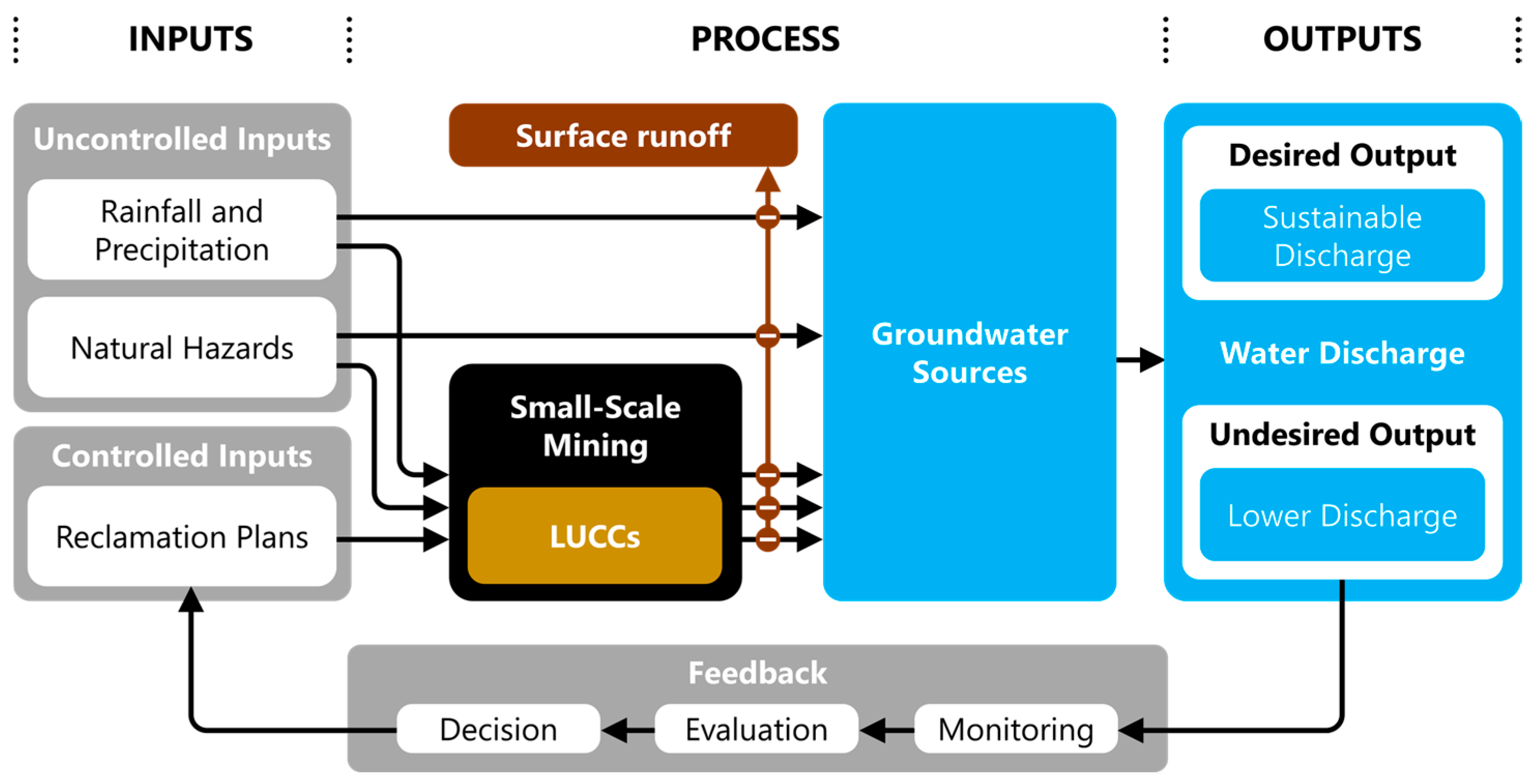
Natural phenomena such as rainfall and precipitation are crucial in recovering groundwater affected by mining-related LUCCs (Figure 1). Precipitation facilitates water infiltration into the subsurface, replenishing aquifers and mitigating the adverse effects of mining activities on groundwater resources. The intensity, duration, and frequency of rainfall determine the extent of groundwater recharge [39], with higher precipitation rates leading to more significant recovery of groundwater levels. Furthermore, natural hazards, such as floods, landslides, and earthquakes, can influence the mining industry’s behavior in modifying the surface landscape. These hazards can disrupt mining operations, damage infrastructure, and alter the topography of the mined areas. Consequently, mining companies may adapt their land use practices and implement measures to mitigate the risks associated with natural hazards [40]. For instance, they may establish flood control, stabilize slopes prone to landslides, or relocate mining activities to less hazardous areas. These adaptations can indirectly affect the extent and severity of mining-induced LUCCs and their subsequent impact on groundwater resources. The interplay between mining-induced LUCCs and groundwater sources is further complicated because rainfall/precipitation and natural hazards act as uncontrolled inputs in this complex system.
On the other hand, reclamation plans serve as controlled inputs to the LUCCs in small-scale mining operations (Figure 1). Basically, reclamation plans outline procedures and requirements for operators to follow during and after mining activities to minimize environmental impacts. When designed and enforced effectively, reclamation plans can curb excessive water appropriation by small-scale mines. These plans could include land remediation strategies to stabilize disturbed areas [41]. However, improper planning and implementation of reclamation scenarios could undermine their efficacy. Cao [42] noted that reclamation requirements for small-scale mines are often vague, allowing substantial leeway in water management. Additionally, limited human resources at relevant agencies hamper consistent monitoring and enforcement, enabling noncompliance. Weak bonding requirements provide little incentive for mines to follow through on closure commitments [43]. Consequently, water-related issues frequently persist post-mining due to factors like incomplete revegetation, erosion, and untreated mine drainage [44]. An improved hydrological analysis could hence be necessary during reclamation planning to devise water management strategies tailored to site-specific conditions [45]. Besides, tighter bonding standards could motivate increased compliance with reclamation objectives. Additionally, post-mining monitoring and maintenance requirements should be extended to better safeguard water resources over the long term [46].

2.3. Post-Mining Land Intervention Scenarios for Groundwater Recovery

Mitigating the impact of LUCCs in small-scale mining operations on natural water sources requires investigating possible intervention scenarios. A business-as-usual (BAU) scenario involving no interventions to restore mining land to its original use/cover is an essential baseline for alternative approaches. While simplistic, analyzing current LUCC rates and practices under a BAU scenario provides vital insights into the scale of the LUCC-induced runoff problems and quantifies the groundwater volumes that could potentially be recharged through interventions [47]. In terms of intervention, reclaiming degraded mining areas into productive fruit plantations has several potential advantages, but the water implications remain uncertain. Revegetating former mining sites with native fruit trees could reduce erosion and sediment loading into downstream waterbodies [48]. Fruit orchards on rehabilitated mining land may also support local economic development through fruit sales [49]. However, fruit orchards have high water requirements, likely offsetting some groundwater recharge potential relative to the BAU scenario. Quantifying the water demands of various fruit tree species and agricultural practices suitable for reclaimed mining land would provide vital data for water management planning [50]. The net impacts on both water quantity and quality must be rigorously evaluated by comparing rehabilitated orchards and non-reclaimed mining areas.
Meanwhile, converting mined land into reservoirs represents a promising intervention to mitigate the impacts of mining-induced LUCCs on water resources [51], though one requiring careful analysis of ecological tradeoffs [52]. Technically, reservoirs could augment water discharge during dry seasons by storing water [53], providing a buffer against mining-related disruptions to the groundwater. Despite being engineering-intensive, reservoirs enable flexible water storage and flood control capabilities relative to natural waterways. Still, altering natural hydrological patterns could negatively impact downstream ecosystems, as in the typical assessments of dams [54]. Ultimately, the proposed BAU, agricultural reuse, and reservoir interventions have merits and consequences. Leaving mining-affected land contours and drainage patterns as they were under BAU may pose fewer land-related risks; however, passive restoration limits the extent of recovery of impacts from ongoing mining activities on water resources [55]. Meanwhile, agricultural reuse could productively repurpose post-mining areas but may introduce tailings runoff issues to surface water streams [56]. In other words, each poses unique tradeoffs requiring scenario analysis (Figure 1). Comparing intervention options to a BAU baseline will enable identifying the rate of changes brought by each scenario. Observing temporal dynamics in these scenarios will then provide an objective basis for selecting an optimal intervention given site-specific conditions.

3. Methodology

3.1. Research Design

The controlled and uncontrolled inputs affecting the impact of LUCCs in small-scale mining on groundwater discharge form complex structural relationships between relevant variables. In observing potential interventions to alter the longer-term impact, systems approaches can help mitigate the water–land risks by identifying the resulting temporal dynamics in water discharge by considering the structural LUCC complexities [57]. In that sense, systems approaches are advantageous compared to static or linear modeling approaches [58]. Since input variabilities occur at aggregated levels, this study applied System Dynamics (SD) to observe the temporal dynamics. Technically, SD allows for modeling the dynamic interactions between various factors that influence water discharge over time. A key advantage of SD is that it can capture feedback effects and time delays, often critical in socio-ecological systems [59]. For instance, changes in mining practices may not have had an impact on water quantity for years due to lag effects. Once these structural complexities are understood, SD models can test scenarios and interventions [60]. This enables simulation of how the system might respond to different interventions. In short, applying SD to the water impacts of small-scale mining could provide significant insights, enabling more informed decision-making regarding LUCCs and water risk in the small-scale open-pit, non-artisanal mining of low-value ores.
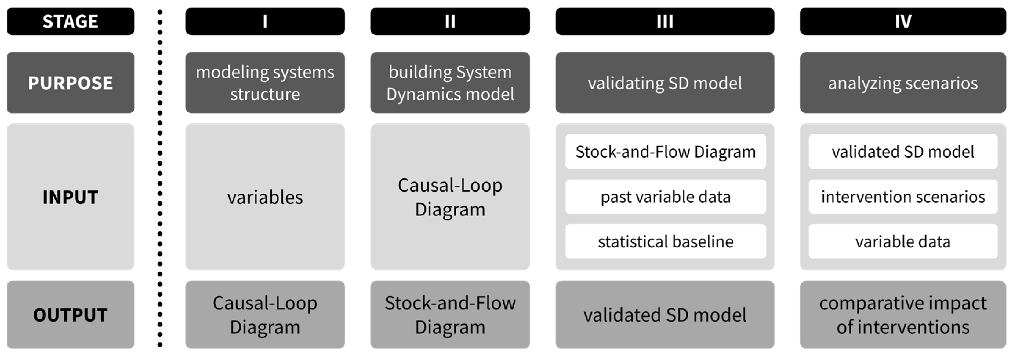
The research design for this study followed a systematic four-stage process (Figure 2) to develop a SD model that captures the structural relationships between LUCCs in small-scale mining and natural water discharge. The first stage involves creating a causal loop diagram (CLD) to visualize the feedback mechanisms and causal links between critical variables in the systems. CLDs use arrows to denote the cause-and-effect relationships, with the arrowheads pointing from the cause to the effect [61]. The CLD produced in stage one provided the basis for developing a more detailed stock-and-flow diagram (SFD) in the second stage. SFDs build quantitative simulation models by specifying stock variables, flow rates, and causal links with mathematical equations [62]. In the third stage, the SFD model is validated to ensure it reproduces historical patterns and behaves logically based on real-world data [63]. This study employed a mean comparison approach [64], which involved comparing the average values generated by the model simulation to the actual historical averages calculated from statistical data. The fourth and final stage involved using the validated SFD model for scenario analyses. The three scenarios mentioned earlier were simulated to observe their impacts on critical variables, especially the natural water discharge. This allowed for the identification of potential interventions and regulations that could optimize the system behavior [65].

3.2. Case Study

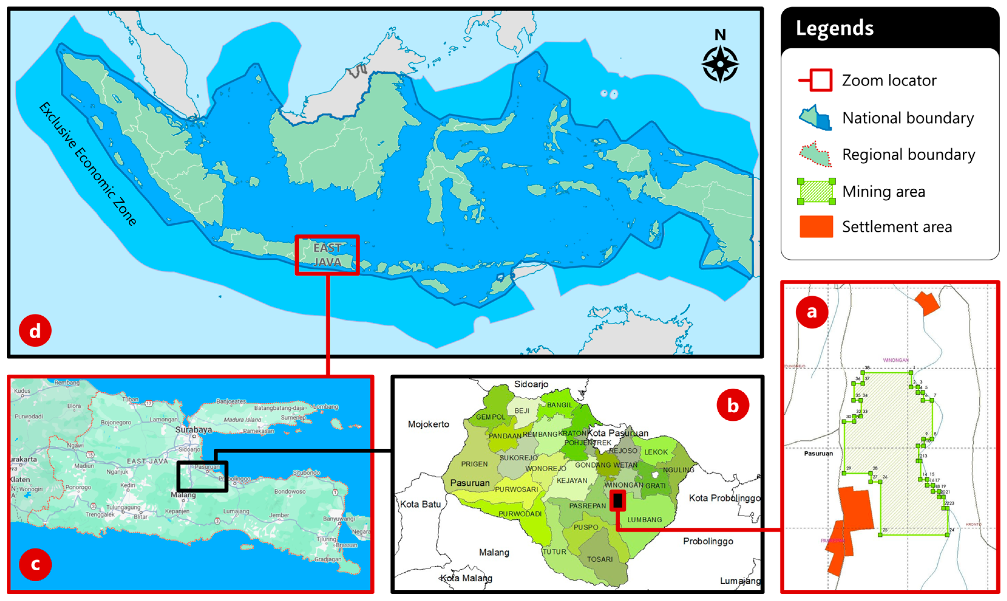
This study observed a small-scale andesite mining site in Pasuruan, East Java, Indonesia (Figure 3), to examine the impact of LUCCs in small-scale open-pit mining operations on water resources. Andesite is an extrusive igneous rock widely used as a construction and building material due to its hardness, compressive strength, and water/weather abrasion resistance properties [66]. In addition, its powdered residues can be used as a mineral additive in concrete [67]. The rapid infrastructure development across Indonesia in recent years has triggered ubiquitous attempts to mine andesite [68,69,70], many of which are small-scale operations with limited regulations and oversights. Andesite production primarily uses water in factory processing, while on-site use is limited to minor mining activities, e.g., cleaning up soils from the rocks, reducing dust, and washing the equipment. Still, open-pit andesite mining drives LUCCs, affecting groundwater recovery due to increased surface runoff. This andesite mining site in Pasuruan was selected due to its proximity to surrounding villages and agricultural areas, and the importance of the water spring that has various other uses. The examination provides an opportunity to understand how small-scale andesite mining affects water resources [71], which allows various stakeholders to be aware of the indirect impacts of massive national infrastructure development programs on local water sources.
The 16.33-hectare andesite mining concession is located across Kedungrejo Village in Winongan District and Petung Village in Pasrepan District [72]. The location places the mine on the lower slopes and foothills of the Bromo Volcano complex, an active stratovolcano within the Bromo Tengger Semeru National Park. Prior to corporate-managed mining activities, local communities occasionally conducted artisanal andesite mining for private construction. The land was utilized for small-scale agriculture and community plantations growing mangoes, bamboo, teak, kapok, etc. (Figure 4). These privately owned lands are now under contractual agreements with a mining company that rents the territories for andesite extraction under a material compensation model. The company has acquired multi-level permits from the authorities to operate, including an IUP (mining business license) granted by the Regent of Pasuruan. The mining operations are planned to commence in 2024 and reach full capacity within the same year. Ecologically, the operations rely on water resources from the Umbulan Spring located nearby, which also supplies freshwater for surrounding rural settlements and agricultural areas [73,74]. Satellite imagery and preliminary field surveys indicate that the mining concession is situated approximately 200 m west and south of the nearest settlements.

4. Results

4.1. Causal-Loop Diagram (CLD)

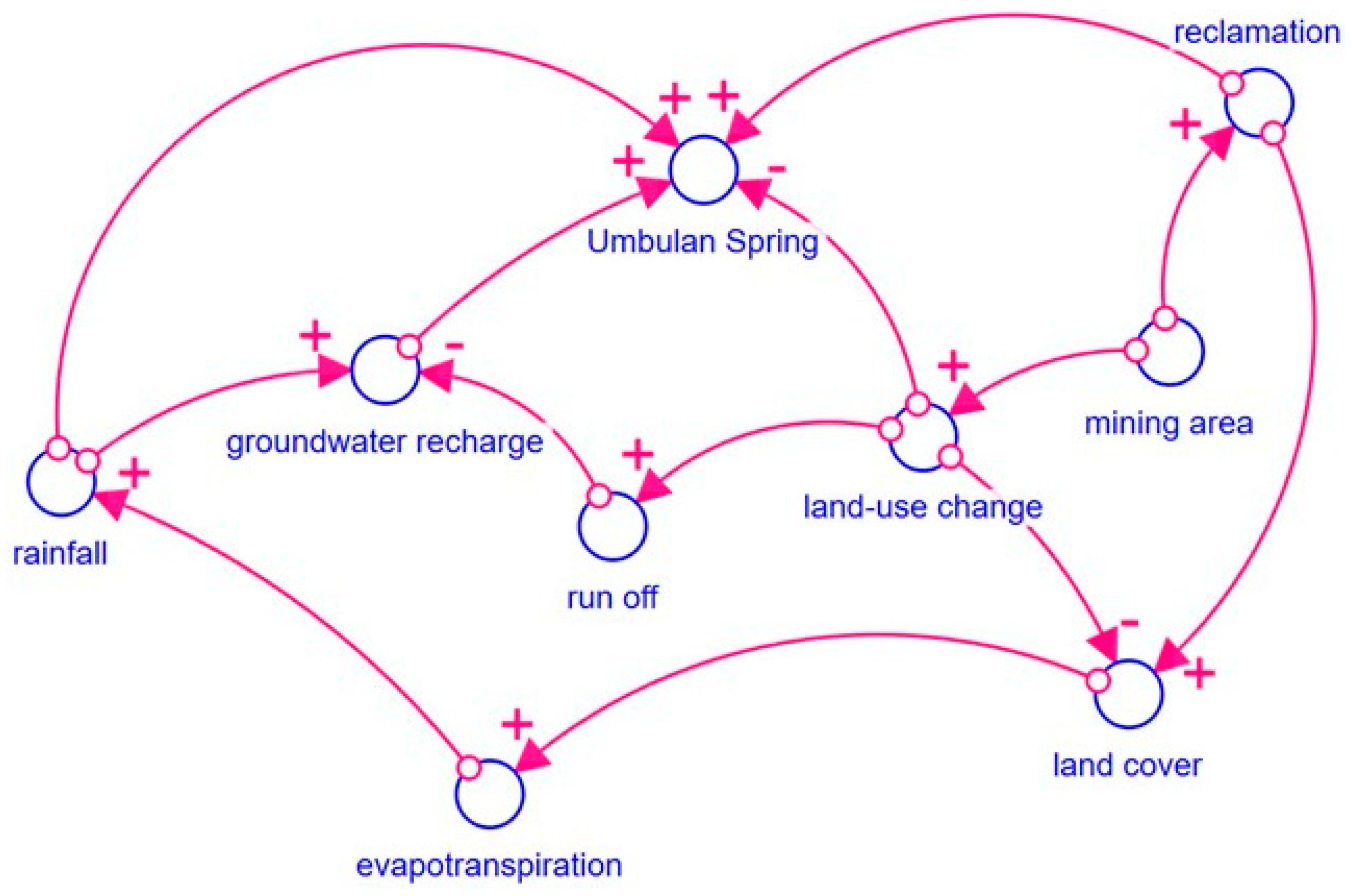
The causal relationships between key variables influencing the water discharge of the Umbulan Spring were mapped into a CLD (Figure 5). The diagram indicates that groundwater recharge in the spring catchment zone positively influences the water discharge. An increase in groundwater recharge leads to a rise in the spring’s potential water discharge volume, while a decrease in recharge reduces the potential discharge volume. Groundwater recharge itself is positively affected by rainfall. Higher rainfall amounts contribute to more significant groundwater recharge, as more water is available to infiltrate into the subsurface. Rainfall might also add water to the spring and, therefore, positively influence the spring’s potential discharge volume. Additionally, the CLD highlights the role of evapotranspiration in influencing rainfall. Evapotranspiration refers to the sum of evaporation and plant transpiration from the land surface to the atmosphere. Higher evapotranspiration provides more moisture to the air, which can precipitate rainfall. Evapotranspiration is, in turn, positively affected by the land cover, which includes vegetation, forests, and other natural landscapes. The more natural land cover leads to higher evapotranspiration and consequently increased rainfall. This forms a reinforcing pathway where land cover enhances evapotranspiration and rainfall, further augmenting groundwater recharge and the spring’s discharge.
However, not all surface water recharges the groundwater, as some runs off the land surface before it can infiltrate. In that sense, groundwater recharge is negatively influenced by surface runoff. When more surface water flows over the land as runoff rather than sinking into the ground, groundwater recharge is reduced. Runoff itself increases due to mining-induced LUCCs replacing natural vegetation, which allows water infiltration, with more impervious surfaces for mining activities. In other words, the changes in land use also pave the way for reducing natural land cover. At the same time, increased use of land concessions for mining operations positively affects land use change, as mining leads to vegetation clearing and other changes in land cover. Furthermore, the larger mining areas also directly lower the Umbulan Spring’s discharge due to the need to extract groundwater to support more intensive mining activities. However, mining areas would be assumed to drive reclamation actions, which aim to restore or rehabilitate the land after mining. Reclamation would positively influence the discharge of the Umbulan Spring by reverting the water impact of mining operations. Reclamation further enhances natural land cover, counteracting, to some extent, the negative impacts of mining area expansion on land use change and land cover reduction.

4.2. Stock-and-Flow Diagram (SFD)

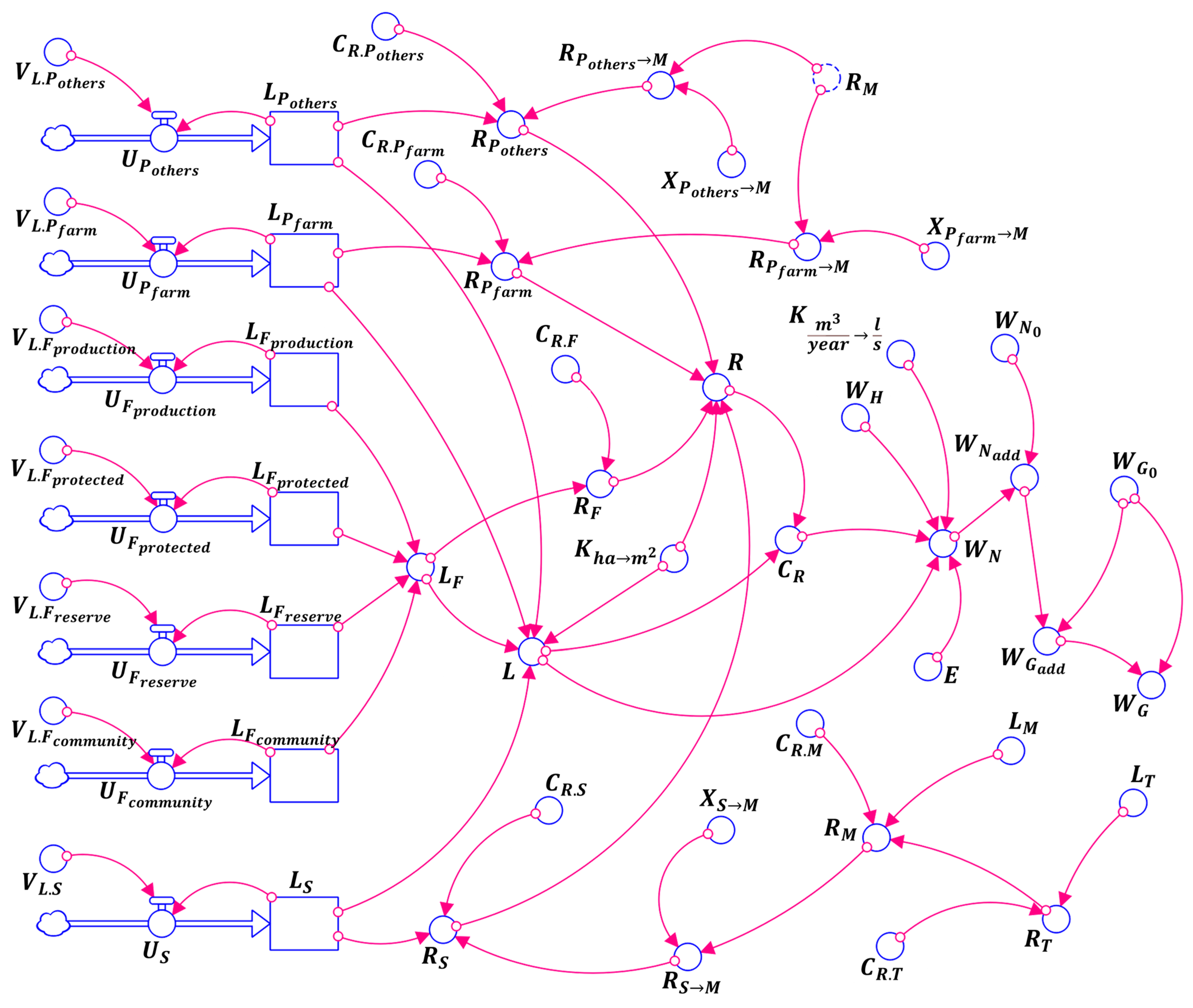
Looking at the CLD (Figure 5), there are structural relationships between the Umbulan Spring’s discharge, groundwater recharge, and LUCCs driven by small-scale mining activities. The stock-and-flow diagram (SFD; Figure 6) then translates the CFD into the explicit structure of the observed systems [75,76]. Corresponding to the CLD, the water discharge of the Umbulan Spring ( W G ) is primarily driven by the temporal dynamics of successful recharges to the groundwater ( W N ). Since groundwater recharge indicates the total volume of surface water that goes into the underground aquifer, the SFD establishes that the recharge ( W N ) occurs due to precipitation from rainfall ( W H ), evapotranspiration from the ground to the air ( E ), and the total land area that allows surface water to filter into the aquifer (catchment). In that sense, total catchment area refers to the entire land within the Umbulan watershed ( L ) minus those with impervious (runoff-causing) characteristics ( R ). According to the Regional Regulation (Peraturan Daerah, or Perda) no. 12/2010 on the Land-Use Planning of Pasuruan Regency 2009–2029 [72], land area ( L ) within the Umbulan watershed is composed of settlements ( L S ), agriculture ( L P ), and forests ( L F ). In practice, land cover for agricultural areas is distinguished into paddy farms ( L P f a r m ) and other crops ( L P o t h e r s ). Meanwhile, forest areas are further classified according to their particular functions [77], including production forests ( L F p r o d u c t i o n ), protected forest ( L F p r o t e c t e d ), nature reserve ( L F r e s e r v e ), and community forest ( L F c o m m u n i t y ). Since land use/cover is a dynamic phenomenon [78,79], temporal changes reflect how much each land use/cover varies over time ( U ) under certain use-specific rates ( V ).
Furthermore, the water absorption characteristics of different land uses depend on their runoff coefficients. The runoff for settlement ( R S ) is technically affected by an average coefficient for settlement areas ( C R . S ). Meanwhile, agricultural lands have different runoff coefficients between paddy fields ( C R . P f a r m ) and areas for other crops ( C R . P o t h e r s ), resulting in specific runoff areas ( R P f a r m and R P o t h e r s , respectively). Regarding forests, the runoff coefficient is assumed to be equal between forest functions ( C R . F ), considering the primarily shared characteristics of forest cover (trees) within the watershed. Moreover, the structural impact of small-scale andesite mining on the Umbulan Spring is incorporated through another subsystem. Since mining operations are granted rights to alter land covers, original LUC within the concession will eventually change to mining lands ( L M ), depending on the mining development. According to the mining permit, most of the mining land ( X ) is an agricultural area (paddy and other crops), while minor portions of the concession, especially in the southern part, are currently the extension of a nearby settlement. Conversions from the original LUC to impervious mining surface (Table 1) lead to different runoff areas between converted settlements ( R S M ), areas for other crops ( R P o t h e r s M ), and paddy farms ( R P f a r m M ), with the same runoff coefficient for the converted surface ( C R . M ). Eventually, post-mining land reclamation strategies affect the total runoff area of the mining concession ( R M ). Reclaimed mining areas ( L T ) have a specific runoff coefficient ( C R . T ) depending on the chosen reclamation strategy, which leads to the scenario-specific runoff area of the reclaimed mining land ( R T ).

4.3. Model Validation

The SFD (Figure 6) requires a model validation to evaluate its internal structure and tendencies. The validation process is a crucial stage in SD modeling to build a convincing basis for sound conclusions about the observed real-world systems [80]. The validation aims to assess whether the SFD suitably represents the actual systems structure [81] and if the simulation results align with real-world data [82]. A model that passes validation tests gives confidence that the model constitutes a good enough representation of the problems so that this study can proceed to the model testing over intervention scenarios. In this study, validity testing focused on percentage errors in the means and variations [64], implying the deviation between the model output and the actual historical data. Precisely, two indicators were calculated: the percentage error in the means ( E 1 , Equation (1)), which compares the average values of simulated ( Z ¯ ) and actual data ( A ¯ ), and the percentage error in the variations ( E 2 , Equation (2)), which measures differences between the deviation of past data ( D A ) and simulation ( D Z ), both of which are for the number of observations ( N ) within the validation period. For this model to be considered valid, the E 1 value should be equal to or less than 5%, while the E 2 value should be equal to or less than 30%. Meeting these thresholds would signify that the discrepancies between model-generated temporal dynamics and real-world data fall within a satisfactory range.
E 1 =   Z A ¯ A ¯   ;   where   Z ¯ = 1 N i = 1 N Z i   and   A ¯ = 1 N i = 1 N A i
E 2 =   D Z D A D A   ;   where   D Z = 1 N ( Z i Z ¯ ) 2   and   D A = 1 N ( A i A ¯ ) 2
Based on the CLD (Figure 5) and SFD (Figure 6), the dependent variable observed is the water discharge of the Umbulan Spring. However, it should be acknowledged that no model can exactly replicate complex real-world systems [83]. Therefore, the model validation focused on observing whether the deviation of model-generated natural water discharge against past water discharge data was less or equal to 5% in terms of means ( E 1 ) and less or equal to 30% for the deviations ( E 2 ). According to the Technical Implementation Unit of Water Resources Management (Unit Pelaksana Teknis Pengelolaan Sumber Daya Air, or UPT PSDA) of the Pasuruan Regency [84], the only available records on the Umbulan Spring’s water discharge were for the period 2012–2014 (Table 2). The data reflect the natural water discharge before the mining operations began. However, the data could relate to socio-ecological changes within the Umbulan watershed, including land-use/cover changes, precipitation, and evapotranspiration within the same period. Consequently, absolute and relative data on land use/cover for the validation period are necessary (Table 3), which vary over time under the land-use/cover change rates. Furthermore, the available precipitation data are at the district level for 2018–2021 (Table 4), which would be backcasted to the validation period. The average evapotranspiration for the region is 105.1199 mm per year. In addition, each land cover has specific characteristics, with varying groundwater recharge rates. Thus, the surface characteristics resulted in the runoff coefficients for different land covers within the watershed (Table 5).
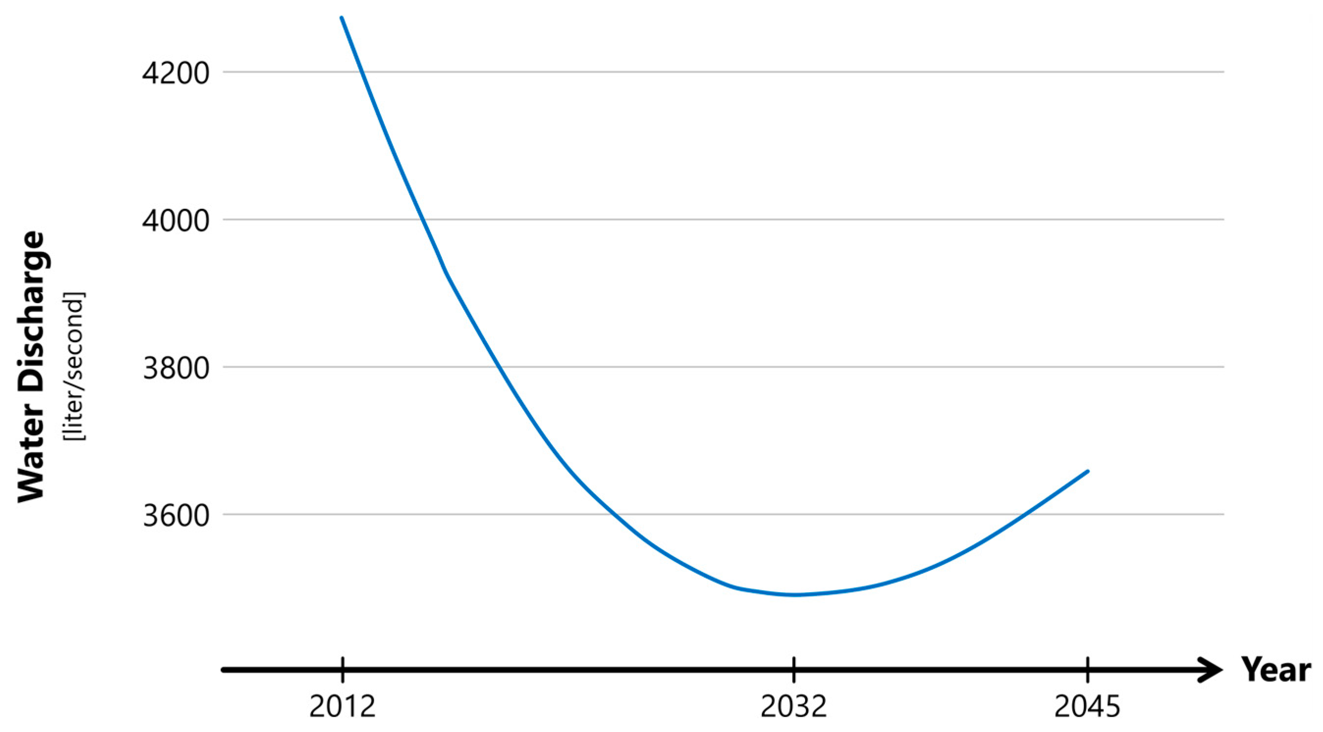
This study validated the model by running the SFD using the only available historical data (2012–2014). Table 6 provides a comparison between the actual statistics and model-generated results for the water discharge of the Umbulan Spring. The differences between the simulated and observed data were quantified using the E 1 and E 2 metrics, with values of 1.17% and −8%, respectively. The E 1 value of less than the 5% threshold confirmed that the model had low bias and accurately captured the central (mean) tendency of the data. Meanwhile, the E 2 value being less than the 30% threshold indicated that the variations among data points did not deviate excessively from the observations. Together, these metrics validated the capability of the SFD to reproduce the dynamics of the Umbulan Spring’s natural water discharge under the no-mining scenario. Beyond validation, the simulation results provide insights into potential emergent behaviors in the coming decades. The simulated projection until 2045 (Figure 7) reveals a curved pattern, with an initial decline until 2032 and a recovery thereafter. Between 2012 and 2014 and 2032, the model projects a sharp drop in natural water discharge. However, the trajectory changes course after the crucial inflection point in 2032, with the water discharge rebounding to the direction of the pre-2032 level within the same temporal distance. The non-symmetrical curve suggests the presence of inherent asymmetry in the pre- and post-2032 dynamics governing spring behavior. Still, the pre-2032 slope is sharper than its post-2032 counterpart, indicating that the rate of decline leading up to 2032 exceeds the rate of recovery post-2032.

4.4. Scenarios

4.4.1. Business as Usual (BAU)

The model validation indicated that the SFD (Figure 6) performs as intended, with only minor deviations from real-world observations (Table 6). This bolstered confidence in the model’s predictive capabilities and its utility in further analysis. This study thus proceeded to scenario analysis investigating different land reclamation strategies and their efficacy in countering the impact of small-scale andesite mining on Umbulan Spring’s water discharge and groundwater recharge. First, this study analyzed a business-as-usual (BAU) scenario to lay the groundwork for the scenario analysis. Basically, a BAU scenario in SD modeling helps us understand systems behavior by simulating the temporal dynamics of observed systems without any interventions [85]. In that sense, it can also simulate the temporal dynamics influenced by a given disruption which, in this case, is small-scale andesite mining without any specific interventions designed to respond to the interruption. In practice, the BAU scenario focuses on the absence of post-mining land reclamation, providing a window into the potential long-term impacts of mining activities on the Umbulan Spring. This scenario is pivotal as it establishes a reference point against which the effects of different reclamation strategies can be compared. The BAU scenario thus complements the no-mining scenario established during the model validation phase. Together, they offer a comprehensive view of the systems’ behavior under natural and disrupted conditions (Table 7). They are essential to understanding the baseline impacts of mining activities on Umbulan Spring’s discharge and groundwater recharge.
This simulation was run under the assumption that the runoff coefficient was equal, at 0.95, for parts of original land uses within the concession converted to more impervious mining land ( C R . M ). This means there is only a 5% chance for surface water to permeate the aquifer to recharge the groundwater. As aforementioned, the observed small-scale andesite mining within the Umbulan watershed was set to begin in 2024, with the full scale of operations planned to be achieved in the same year. Thus, the BAU scenario was run from 2024. Table 7 provides the results of the simulation for the BAU scenario. Looking at the temporal dynamics, the curve of spring discharge reflects a behavior similar to that of the no-mining scenario. Consistent decreases occur from the beginning of the mining operations in 2024 until an inflection point in 2032. After that, the mining-affected water discharge of the Umbulan Spring remains able to recover to a limited extent. Still, the highest impact of mining operations occurs in 2038, with a 2.77-L loss of discharge per second, or approximately 87.35 thousand tons loss of discharge potential within that year. Until the end of the observation period in 2045, the mining operations cause an average loss of 2.07 L per second of the spring’s discharge, or approximately 65.31 thousand tons annually. In addition, the land conversion for mining operations reduces the capability of the surface to recharge the groundwater by an average of 3.57 L per second, or approximately 112.54 thousand tons of loss of annual potential for groundwater recharge.

4.4.2. Agricultural Scenario: Reclamation into Mango and Cassava Plantations

The BAU scenario provided a baseline for investigating the efficacy of possible land reclamation strategies in assisting the recovery of Umbulan Spring’s water discharge and groundwater recharge. The first post-mining land reclamation strategy focuses on the revegetation of mining land. This scenario aims to restore the permeability of the former mining surface. In that sense, this land reclamation applies only to excavated parts of the concession. Technically, this scenario employs 100% revegetation for excavated mining areas the year after mining activities conclude for the specific location. This intervention involves planting mango and cassava trees to reconvert the excavated mining areas into croplands. Basically, planting trees offers advantages for groundwater recharge since they allow more water to enter and raise groundwater [86]. Intermediate tree cover can maximize groundwater recharge in areas with seasonally dry tropical climates, including the Umbulan watershed [87]. Economically, mango and cassava also offer consumable and sellable products for the landowners of the mining area. In fact, mango trees are the original crops within the land concession, predating the mining operations (Figure 4). This would thus increase the probability of success. Meanwhile, planting cassava completes an intercropping approach to establish better ecosystems that benefit the crops, the farmers (landowners), and the environment [88]. In addition, mango has root systems that go deep into the ground, while cassava’s root systems grow at shallow soil levels. Mechanically, their root systems complement each other to build better soil permeability at different depths, allowing more surface water to sink into the aquifer.
Since this scenario attempts to restore soil absorption capability by replanting impervious mining surfaces with crops, the simulation applied the runoff coefficient for agricultural plantations ( C R . P o t h e r s ) to the reconverted areas. It promises a 15.8% reduction in runoff coefficient (Table 5), which should lead to improvements toward both the spring’s discharge and groundwater recharge. Technically, the impact of this scenario would start occurring in 2025 since the mango and cassava planting would begin in the second year of mining operations. Table 7 provides the results of simulations for this intervention, along with BAU and no-mining scenarios. This agricultural intervention exhibits slight improvements against mining-induced temporal dynamics in the BAU scenario. There is an average improvement of 19.57% in water discharge against the BAU scenario. In absolute numbers, this agricultural scenario can annually restore approximately 14.25 thousand tons of the Umbulan Spring’s discharge on average. Meanwhile, this agricultural intervention can add about 35.41 thousand tons of water for average groundwater recharge annually, an approximately 28.64% average improvement compared to the BAU scenario. However, this scenario remains unable to restore the water discharge and groundwater recharge to pre-mining levels. There is still a 1.64 L per second average loss of the spring’s discharge compared to no-mining situations, or approximately 51.70 thousand tons of average water loss annually. In addition, this intervention cannot reverse the loss of recharge potential of the groundwater. Approximately 2.5 L per second of average loss occurred to the groundwater recharge or about 78.74 thousand tons of surface water that cannot infiltrate the aquifer annually.

4.4.3. Reservoir Scenario: Reclamation into Water Reservoir

The second post-mining land reclamation strategy aims to provide a buffer to reduce the need to use the Umbulan Spring discharge by storing water on the surface. The new waterbody is also intended to optimize the potential of groundwater recharge. This intervention is applied by converting excavated parts of the concession into a water reservoir. Technically, the conversion would be performed annually for 100% mined areas where the mining operations completed excavating the previous year. This land reclamation takes advantage of the original characteristics of the concession areas as an andesite outcrop. Its hydraulic properties form a generally impermeable surface at considerable depths [89], making it difficult, to some extent, for rainwater to infiltrate into the aquifer. It suggests a promising attribute for a water reservoir. Since this reclamation strategy applies to excavated areas, the initially impermeable characteristics may no longer hold true. Thus, this reservoir scenario proposes to reclaim the mined area using appropriate soil types or textures to rebuild, or at least mimic, the original hydraulic properties. Instead of using nearby agricultural soils, this intervention considers mixing sands and gravel to form a desired surface for the water reservoir. Unlike loamy-textured agricultural soils [90], sands and gravels cannot absorb water. However, they offer high hydraulic conductivity that enables water to easily pass through pore spaces between sands and gravels [91]. This reservoir scenario attempts to link these properties to make the surface able to hold water while at the same time allowing enough water to seep through to recharge the groundwater.
The mix of sand and gravel aims to form a surface with a 30% water absorption rate. In other words, the desired runoff coefficient of the formed surface for the water reservoir is 0.7, offering a 27.8% improvement against the surface characteristics during mining operations (Table 5). Similar to the agricultural intervention, this reservoir scenario applies to excavated mining areas, ensuring impact only from the year after the mining operations began. However, these interventions are not applicable side-by-side since they attempt to convert the same excavated areas under the exact intervention timing. Looking at the simulation results (Table 7), this scenario shows much better temporal improvements compared to the BAU scenario. On average, the reservoir scenario adds 1.24 L per second to the post-mining water discharge, offering a striking 53.48% improvement. Annually, it promises approximately 39.15 thousand tons of average additional water discharge to the Umbulan Spring. However, this scenario leaves an average annual loss of 27.94 thousand tons of water compared to natural water discharge under the no-mining scenario. In terms of groundwater recharge, the reservoir scenario exhibits a solid capability to recover the mining-induced loss of recharge potential. After delivering a gradual improvement behavior similar to that of the agricultural scenario, this reservoir intervention delivers a complete recovery of the groundwater recharge to the pre-mining level in 2039. Still, enormous temporal losses of groundwater recharge and water discharge prior to the recharge recovery point make the Umbulan Spring unable to provide the same water discharge level even after 2039.

5. Discussion

This study has highlighted a significant research gap regarding the impacts of small-scale open-pit, non-artisanal mining of low-value ores, with an example of andesite mining, on natural water sources. In agreement with Mutemeri and Petersen [31], neglecting the small-scale mining sector due to its modest outputs and basic technologies used can create severe negative ecological and social impacts. This study particularly explores the fact that influencing even small volumes of groundwater recharge from limited regional water sources could significantly affect rural communities and ecosystems dependent on the same water supplies. It is founded on the argument that the cumulative impacts from LUCCs driven by small-scale non-artisanal mining within the same watershed could be substantial over time. As stated by Herrera [92], this amplifying effect means that what appears negligible on more minor scales at a single point in time can have much more significant consequences on an aggregate scale over more extended periods. Thus, this research utilized simulations which, as suggested by Khan et al. [93], could help track changes in water discharge and groundwater recharge over time, providing more meaningful insights compared to static snapshots. In particular, the modeling and analysis reveal whether freshwater resources can adequately replenish themselves during and after mining operations. If not, even a low intensity but sustained mining could progressively drain springs and aquifers faster than natural recharge rates.
In this study, the first simulation results demonstrated the long-term impacts of the projected LUCCs driven by the small-scale mining activities on the Umbulan Spring under the BAU scenario. As established in the literature [94,95], this scenario offers an essential baseline reflecting the systems’ behavior without any intervention efforts, against which to evaluate the systems’ responses to different intervening strategies. To begin with, the almost complete loss of infiltration capacity on the converted land, as indicated by the runoff coefficient of 0.95, is alarming. In general, the simulated water discharge of the Umbulan Spring follows a similar curve pattern as the natural (no-mining) conditions from 2024 to 2045. Unlike the inflection point of the no-mining and BAU curves in 2032, the impacts of the andesite mining on the water discharge on Umbulan Spring peak in 2038 with an estimated 87.35 tons annual loss. Remarkably, unremedied mining-induced impacts over the course of 21 years could cumulatively reduce the spring’s discharge by more than 1.4 million tons. The results align with prior hydrogeological studies [96,97,98], whereby a reduced groundwater recharge decreases discharge from associated springs. Still, while the expected finding was the negligible ecological impact of small-scale non-artisanal mining, the scale of losses modeled here exceeds initial expectations.
With these projections in mind, this study highlights the critical need for post-mining reclamation to mitigate the impacts of the mining-induced LUCCs. The results for the agricultural scenario demonstrate that revegetating the mining area with mango and cassava trees can lead to moderate improvements in spring discharge and groundwater recharge compared to the BAU scenario. As suggested by Koſodziej et al. [99], converting the mined land back to agricultural use helps restore some permeability of the soil. However, while revegetation with deep-rooted mango trees and shallow-rooted cassava plants moderately enhances rainwater infiltration and recharge potential, it fails to fully restore hydrological functions. The largely irreversible destruction of soil structures and hydraulic conductivity from the open-pit mining process obstructs a complete restoration of the watershed. This aligns with previous research demonstrating that heavily disturbed land is unlikely to reach its original ecosystem services even with reclamation efforts [100]. Nonetheless, the study shows that agricultural reconversion is also a viable starting point for partially reviving ecosystem functions. As Rowe et al. [101] noted, combining deeper-rooted trees with understory crops promotes soil recovery and nutrient cycling. Building on this revegetation approach through more diverse, climate-resilient crops and agroforestry systems could amplify benefits. Carefully planted vegetation also helps stabilize landslides in reclaimed mining regions [102].
Furthermore, converting excavated areas into a water reservoir demonstrates a more promising impact. In fact, the results indicate that this reservoir intervention significantly outperforms the agricultural scenario in improving the Umbulan Spring’s water discharge over time. Studies on mining-impacted regions worldwide have demonstrated that engineered reservoirs, dams, and other water impoundments on reclaimed mining lands can substantially improve surface and underground water availability [51,52,103,104]. In the longer term, the reservoir intervention suggests immense potential for recovering lost groundwater recharge to pre-mining conditions by 2039. This finding implies that the improved hydraulic conductivity offered by the sand–gravel mix facilitates a steady post-mining recharge of the Umbulan groundwater. This confirms previous research [105,106] that found runoff coefficients between 0.6 and 0.8 as natural levels enabling adequate surface accumulation while permitting sufficient aquifer recharge within a watershed or water basin. The 0.7 runoff coefficient targeted in this study falls comfortably within this natural range. Still, the literature indicates uncertainties regarding the long-term adequacy of a reservoir intervention. As noted by prior studies [107,108], human-made reservoirs on reclaimed land within mining sites can experience substantial evaporative losses, seepage issues, and declining storage capacities over time. Additionally, the use of former mining lands may lead to a hit-or-miss utilization due to unfavorable topographic or soil conditions with risks of landslides [109,110,111,112].
In practice, the agricultural intervention is indeed applicable to the observed spring and mining concession. Legally, the proposed reconversion to cropland falls within Regional Regulation no. 12/2010 of the Pasuruan Regency [72]. Article 44 in the medium-term land-use planning document (2009–2029), which also mentions a reference to Article 29 of the same regulation, states that agricultural plantation (kawasan perkebunan) is part of the legal plans for regional cultivation areas. The intervention is also a direct legal response to part of Clause 3 of Article 47, which requires efforts to minimize the possibility of negative impacts arising from mining activities. On the other hand, the reservoir scenario does not fall within the current land-use planning for the Umbulan region. It requires revised land-use planning that must consider much more complex interactions between land-use/cover changes and socio-ecological developments in the broader area [113,114]. Despite its higher efficacy, the reservoir scenario demands more regulatory and political discussions than the agricultural scenario, which can be executed immediately. Moreover, a government-funded reservoir construction suggests that the government must be well-prepared to conduct meticulous processes of water resource bureaucracies [115,116,117,118]. Consequently, planning to apply the reservoir scenario raises doubt about its legal and technical readiness in the second year of mining operations.
Systems thinking applied in this study has demonstrated its effectiveness in understanding the complex real-world problems associated with groundwater recovery and small-scale open-pit, non-artisanal andesite mining. This research has validated the utility of this approach in connecting seemingly distant impacts of variables within complex systems, as stated by previous studies [119,120]. The SD model developed has successfully linked mining-driven LUCCs with those driven by other socioeconomic developments in the surrounding areas, systemically and systematically affecting the groundwater recovery within the Umbulan watershed and the water discharge potential of the Umbulan Spring. This systemic and systematic impact assessment is a key advantage of systems thinking [121,122], as it allows for a holistic understanding of the complex relationships between various factors affecting groundwater recovery. Furthermore, the SD-based scenario assessment in this study demonstrates the additional capabilities of complex systems modeling in predicting future systems behavior organically [123,124,125]. Unlike quasi-systems modeling that relies on past trends [126,127,128], the complex systems approach leverages the complexities between various endogenous and exogenous variables that affect systems’ behavior systemically and systematically. This enables a more accurate and reliable prediction of the effects of post-mining interventions on groundwater recharge, providing much more valuable insights for various stakeholders.

6. Conclusions

Mining is a water-intensive sector. Using the same freshwater sources as nearby communities creates conflicts over socio-ecological needs. While extensive studies exist on the impact of large-scale mining on water resources, small-scale open-pit, non-artisanal mining of low-value ores has received little attention because of its presumed negligible water use. However, its environmental legacies can be critical if LUCCs are inappropriately anticipated. This highlights the need to study the temporal effects of LUCCs driven by the small-scale mining of low-value rocks on vital freshwater resources. The cumulative, long-term impacts could be significant for nearby communities dependent on the same water sources. This study addresses this gap by investigating the impacts of LUCCs driven by small-scale open-pit, non-artisanal mining and other spatial developments in the surrounding areas on natural water sources over time. Dynamic modeling captured temporal variations in water discharge, while different reclamation scenarios revealed post-mining dynamics. Connecting mining-induced LUCCs, non-mining LUCCs, long-term water discharge, and groundwater recharge provides a comprehensive understanding of how even modest mining alters regional hydrology. The first research objective utilized simulations to understand the temporal dynamics of the water discharge potential, while the second examined remediation options for groundwater recovery.
Taking the case of andesite mining in Pasuruan, Indonesia, and the Umbulan Spring, this research found that LUCCs driven by small-scale mining operations of low-value ores do impact the water discharge volume of nearby natural water sources. In a natural (no-mining) scenario, the spring’s water discharge exhibits a curved shape, with consistent decreases until an inflection point in 2032. Answering the first research question (RQ1), the LUCCs could further reduce the water discharge by approximately 1.44 million tons in the next two decades. Mining-driven LUCCs also cause approximately 2.48 million tons of water to run off the surface, affecting groundwater recharge. Countering the undesired impacts, this study proposes two post-mining interventions. Each scenario aims to repurpose fully excavated parts of the mining land into cropland or a water reservoir. Answering the second question (RQ2), the reservoir scenario appears to offer better improvements against the agricultural intervention. Despite targeting precisely the exact size of mining land annually, the reservoir scenario promises an additional 822.14 million tons of water discharge on top of the BAU scenario, which is approximately 2.75x higher than the impact of the agricultural scenario. The reservoir scenario can eventually restore the groundwater recharge potential to the natural (no-mining) conditions in 2039, while the agricultural scenario can only reduce the impact of mining-induced LUCCs on the recharge potential by an average of 28.64%.
These findings are crucial insights to inform better policies toward the widespread but understudied practice of small-scale non-artisanal mining. Simulated reductions in spring discharge potential and groundwater recharge highlight the vulnerability of the hydrological systems even against small-scale mining operations. This stresses the need for evidence-based guidelines on permitting small-scale mining based on site-specific water resource assessments. Policymakers could also implement caps on allowable runoff coefficients or mandated aquifer recharge rates for small-scale non-artisanal mines. Additionally, the varied outputs of the two post-mining scenarios highlight the importance of testing more optimized scenarios. Since the agricultural scenario alone is insufficient for full recovery, further research should explore different combinations of revegetation with water harvesting/storage techniques. Through further scenario assessments, their unique hydrological benefits may prove complementary. This could also entail field testing of different crop types and complementary water infrastructure (e.g., micro-scale monitoring dams). Small-scale non-artisanal mines could also be mandated to financially support third-party monitoring of connected water systems to rapidly provide data on the efficacy of reclamation efforts and detect emerging issues. An integrated policy approach with customized technical guidelines, risk-based permitting, adaptive rehabilitation requirements, and participatory watershed-scale solutions can help balance small-scale non-artisanal mining development and ecological sustainability.
Author Contributions

Conceptualization, M.K., R.P., C.P.M.S., and S.H.; methodology, R.P., C.P.M.S. and S.H.; software, R.P. and C.P.M.S.; validation, M.K., R.P., C.P.M.S., G.C. and S.H.; formal analysis, R.P. and C.P.M.S.; investigation, R.P. and C.P.M.S.; resources, M.K., R.P. and C.P.M.S.; data curation, R.P. and C.P.M.S.; writing—original draft preparation, R.P. and C.P.M.S.; writing—review and editing, M.K., R.P., C.P.M.S., G.C. and S.H.; visualization, C.P.M.S.; supervision, M.K., C.P.M.S., G.C. and S.H.; project administration, M.K., R.P., G.C. and S.H.; funding acquisition, M.K. and R.P. All authors have read and agreed to the published version of the manuscript.

Funding

This research was funded by Brawijaya University through the Dosen Berkarya (Dokar) program, funding period 2023.

Data Availability Statement

The data presented in this study were taken from secondary sources and are available on request from their respective institutions.

Conflicts of Interest

The authors declare no conflicts of interest. The funder had no role in the design of the study; in the collection, analyses, or interpretation of data; in the writing of the manuscript; or in the decision to publish the results.

References

  1. Li, X.; Zhang, Q.; Liu, Y.; Song, J.; Wu, F. Modeling Social–Economic Water Cycling and the Water–Land Nexus: A Framework and an Application. Ecol. Model. 2018, 390, 40–50. [Google Scholar] [CrossRef]
  2. Nwogwu, N.A.; Ajala, O.A.; Omotade, I.F.; Babalola, T.E.; Ajibade, T.F.; Lasisi, K.H.; Adelodun, B.; Ajibade, F.O. Environmental Impacts of Irrigation. In Handbook of Irrigation Hydrology and Management; CRC Press: Boca Raton, FL, USA; ISBN 9780429290114.
  3. Nobre, R.L.G.; Caliman, A.; Cabral, C.R.; Araújo, F. de C.; Guérin, J.; Dantas, F. da C.C.; Quesado, L.B.; Venticinque, E.M.; Guariento, R.D.; Amado, A.M.; et al. Precipitation, Landscape Properties and Land Use Interactively Affect Water Quality of Tropical Freshwaters. Sci. Total Environ. 2020, 716, 137044. [Google Scholar] [CrossRef]
  4. He, Y.; Wang, Z. Water-Land Resource Carrying Capacity in China: Changing Trends, Main Driving Forces, and Implications. J. Clean. Prod. 2022, 331, 130003. [Google Scholar] [CrossRef]
  5. Zhong, H.; Feng, K.; Sun, L.; Tian, Z.; Fischer, G.; Cheng, L.; Castillo, R.M. Water-Land Tradeoffs to Meet Future Demands for Sugar Crops in Latin America and the Caribbean: A Bio-Physical and Socio-Economic Nexus Perspective. Resour. Conserv. Recycl. 2021, 169, 105510. [Google Scholar] [CrossRef]
  6. Yang, J.; Wei, H.; Quan, Z.; Xu, R.; Wang, Z.; He, H. A Global Meta-Analysis of Coal Mining Studies Provides Insights into the Hydrologic Cycle at Watershed Scale. J. Hydrol. 2023, 617, 129023. [Google Scholar] [CrossRef]
  7. Custodio, E.; Andreu-Rodes, J.M.; Aragón, R.; Estrela, T.; Ferrer, J.; García-Aróstegui, J.L.; Manzano, M.; Rodríguez-Hernández, L.; Sahuquillo, A.; Villar, A. del Groundwater Intensive Use and Mining in South-Eastern Peninsular Spain: Hydrogeological, Economic and Social Aspects. Sci. Total Environ. 2016, 559, 302–316. [Google Scholar] [CrossRef]
  8. Masood, N.; Hudson-Edwards, K.; Farooqi, A. True Cost of Coal: Coal Mining Industry and Its Associated Environmental Impacts on Water Resource Development. J. Sustain. Min. 2020, 19, 1. [Google Scholar] [CrossRef]
  9. Sonter, L.J.; Moran, C.J.; Barrett, D.J.; Soares-Filho, B.S. Processes of Land Use Change in Mining Regions. J. Clean. Prod. 2014, 84, 494–501. [Google Scholar] [CrossRef]
  10. Miller, A.J.; Zégre, N. Landscape-Scale Disturbance: Insights into the Complexity of Catchment Hydrology in the Mountaintop Removal Mining Region of the Eastern United States. Land 2016, 5, 22. [Google Scholar] [CrossRef]
  11. Northey, S.A.; Mudd, G.M.; Saarivuori, E.; Wessman-Jääskeläinen, H.; Haque, N. Water Footprinting and Mining: Where Are the Limitations and Opportunities? J. Clean. Prod. 2016, 135, 1098–1116. [Google Scholar] [CrossRef]
  12. Kambani, S.M. Small-Scale Mining and Cleaner Production Issues in Zambia. J. Clean. Prod. 2003, 11, 141–146. [Google Scholar] [CrossRef]
  13. Kazapoe, R.W.; Amuah, E.E.Y.; Abdiwali, S.A.; Dankwa, P.; Nang, D.B.; Kazapoe, J.P.; Kpiebaya, P. Relationship between Small-Scale Gold Mining Activities and Water Use in Ghana: A Review of Policy Documents Aimed at Protecting Water Bodies in Mining Communities. Environ. Chall. 2023, 12, 100727. [Google Scholar] [CrossRef]
  14. Long, R.; Renne, E.; Robins, T.; Wilson, M.; Pelig-Ba, K.; Rajaee, M.; Yee, A.; Koomson, E.; Sharp, C.; Lu, J.; et al. Water Values in a Ghanaian Small-Scale Gold Mining Community. Hum. Organ. 2013, 72, 199–210. [Google Scholar] [CrossRef]
  15. Mercado-Garcia, D.; Block, T.; Cotrina, J.T.H.; Arroyo, N.D.; Forio, M.A.E.; Wyseure, G.; Goethals, P. Freshwater Management Discourses in the Northern Peruvian Andes: The Watershed-Scale Complexity for Integrating Mining, Rural, and Urban Stakeholders. Int. J. Environ. Res. Public Health 2023, 20, 4682. [Google Scholar] [CrossRef]
  16. Northey, S.A.; López, C.M.; Haque, N.; Mudd, G.M.; Yellishetty, M. Production Weighted Water Use Impact Characterisation Factors for the Global Mining Industry. J. Clean. Prod. 2018, 184, 788–797. [Google Scholar] [CrossRef]
  17. Garzonio, C.A.; Piccinini, L.; Gargini, A. Groundwater Modeling of Fractured Aquifers in Mines: The Case Study of Gavorrano (Tuscany, Italy). Rock Mech. Rock Eng. 2014, 47, 905–921. [Google Scholar] [CrossRef]
  18. Collon, P.; Fabriol, R.; Buès, M. Modelling the Evolution of Water Quality in Abandoned Mines of the Lorraine Iron Basin. J. Hydrol. 2006, 328, 620–634. [Google Scholar] [CrossRef]
  19. Cook, P.G.; Miller, A.D.; Wallis, I.; Dogramaci, S. Facilitating Open Pit Mine Closure with Managed Aquifer Recharge. Groundwater 2022, 60, 477–487. [Google Scholar] [CrossRef] [PubMed]
  20. Zektser, I.S.; Loaiciga, H.A. Groundwater Fluxes in the Global Hydrologic Cycle: Past, Present and Future. J. Hydrol. 1993, 144, 405–427. [Google Scholar] [CrossRef]
  21. Zhang, J.; Song, J.; Cheng, L.; Zheng, H.; Wang, Y.; Huai, B.; Sun, W.; Qi, S.; Zhao, P.; Wang, Y.; et al. Baseflow Estimation for Catchments in the Loess Plateau, China. J. Environ. Manag. 2019, 233, 264–270. [Google Scholar] [CrossRef] [PubMed]
  22. Wang, T.-T.; Zhan, S.-S.; Chen, C.-H.; Su, W.-C. Characterizing Fractures to Mitigate Inrush of Water into a Shaft Using Hydrogeological Approaches. Tunn. Undergr. Space Technol. 2017, 61, 205–220. [Google Scholar] [CrossRef]
  23. Wang, X.; Wei, Y.; Jiang, T.; Hao, F.; Xu, H. Elastic–Plastic Criterion Solution of Deep Roadway Surrounding Rock Based on Intermediate Principal Stress and Drucker–Prager Criterion. Energy Sci. Eng. 2024, 12, 2472–2492. [Google Scholar] [CrossRef]
  24. Galhardi, J.A.; Bonotto, D.M. Hydrogeochemical Features of Surface Water and Groundwater Contaminated with Acid Mine Drainage (AMD) in Coal Mining Areas: A Case Study in Southern Brazil. Environ. Sci. Pollut. Res. 2016, 23, 18911–18927. [Google Scholar] [CrossRef]
  25. Abdoulhalik, A.; Ahmed, A.A. Transient Investigation of Saltwater Upconing in Laboratory-Scale Coastal Aquifer. Estuar., Coast. Shelf Sci. 2018, 214, 149–160. [Google Scholar] [CrossRef]
  26. Cai, J.; Taute, T.; Schneider, M. Saltwater Upconing Below a Pumping Well in an Inland Aquifer: A Theoretical Modeling Study on Testing Different Scenarios of Deep Saline-Groundwater Pathways. Water Air Soil Pollut. 2014, 225, 2203. [Google Scholar] [CrossRef]
  27. Masoud, M. Groundwater Resources Management of the Shallow Groundwater Aquifer in the Desert Fringes of El Beheira Governorate, Egypt. Earth Syst. Environ. 2020, 4, 147–165. [Google Scholar] [CrossRef]
  28. Wang, W.; Dai, Z.; Zhao, Y.; Li, J.; Duan, L.; Wang, Z.; Zhu, L. A Quantitative Analysis of Hydraulic Interaction Processes in Stream-Aquifer Systems. Sci. Rep. 2016, 6, 19876. [Google Scholar] [CrossRef]
  29. Burke, G. Opportunities for Environmental Management in the Mining Sector in Asia. J. Environ. Dev. 2006, 15, 224–235. [Google Scholar] [CrossRef]
  30. Ghose, M.K. Indian Small-Scale Mining with Special Emphasis on Environmental Management. J. Clean. Prod. 2003, 11, 159–165. [Google Scholar] [CrossRef]
  31. Mutemeri, N.; Petersen, F.W. Small–Scale Mining in South Africa: Past, Present and Future. Nat. Resour. Forum 2002, 26, 286–292. [Google Scholar] [CrossRef]
  32. Nalule, V.R. Mining and the Law in Africa, Exploring the Social and Environmental Impacts; Palgrave Pivot: Cham, Switzerland, 2019; pp. 51–81. [Google Scholar] [CrossRef]
  33. Abiye, T.A.; Bhattacharya, P. Arsenic Concentration in Groundwater: Archetypal Study from South Africa. Groundw. Sustain. Dev. 2019, 9, 100246. [Google Scholar] [CrossRef]
  34. Schrader, A.; Winde, F.; Erasmus, E. Using Impacts of Deep-Level Mining to Research Karst Hydrology—A Darcy-Based Approach to Predict the Future of Dried-up Dolomitic Springs in the Far West Rand Goldfield (South Africa). Part 1: A Conceptual Model of Recharge and Inter-Compartmental Flow. Environ. Earth Sci. 2014, 72, 3549–3565. [Google Scholar] [CrossRef]
  35. Ochieng, G.M.; Seanego, E.S.; Nkwonta, O.I. Impacts of Mining on Water Resources in South Africa: A Review. Sci. Res. Essays 2010, 5, 3351–3357. [Google Scholar]
  36. Singh, A.K.; Mondal, G.C.; Singh, T.B.; Singh, S.; Tewary, B.K.; Sinha, A. Hydrogeochemical Processes and Quality Assessment of Groundwater in Dumka and Jamtara Districts, Jharkhand, India. Environ. Earth Sci. 2012, 67, 2175–2191. [Google Scholar] [CrossRef]
  37. Eyankware, M.O.; Nnajieze, V.S.; Aleke, C.G. Geochemical Assessment of Water Quality for Irrigation in Abandoned Limestone Quarry Pit at Nkalagu Area, Southern Benue Trough, Nigeria. Environ. Earth Sci. 2018, 77, 66. [Google Scholar] [CrossRef]
  38. Singaraja, C.; Chidambaram, S.; Anandhan, P.; Prasanna, M.V.; Thivya, C.; Thilagavathi, R. A Study on the Status of Saltwater Intrusion in the Coastal Hard Rock Aquifer of South India. Environ. Dev. Sustain. 2015, 17, 443–475. [Google Scholar] [CrossRef]
  39. Lorenzo-Lacruz, J.; Garcia, C.; Morán-Tejeda, E. Groundwater Level Responses to Precipitation Variability in Mediterranean Insular Aquifers. J. Hydrol. 2017, 552, 516–531. [Google Scholar] [CrossRef]
  40. Mavrommatis, E.; Damigos, D.; Mirasgedis, S. Towards a Comprehensive Framework for Climate Change Multi-Risk Assessment in the Mining Industry. Infrastructures 2019, 4, 38. [Google Scholar] [CrossRef]
  41. Lima, A.T.; Mitchell, K.; O’Connell, D.W.; Verhoeven, J.; Cappellen, P.V. The Legacy of Surface Mining: Remediation, Restoration, Reclamation and Rehabilitation. Environ. Sci. Polic. 2016, 66, 227–233. [Google Scholar] [CrossRef]
  42. Cao, X. Regulating Mine Land Reclamation in Developing Countries: The Case of China. Land Polic. 2007, 24, 472–483. [Google Scholar] [CrossRef]
  43. Intarapravich, D.; Clark, A.L. Performance Guarantee Schemes in the Minerals Industry for Sustainable Development the Case of Thailand. Resour. Polic. 1994, 20, 59–69. [Google Scholar] [CrossRef]
  44. Wei, X.; Wolfe, F.A.; Li, Y. Mine Drainage and Oil Sand Water. Water Environ. Res. 2015, 87, 1373–1391. [Google Scholar] [CrossRef] [PubMed]
  45. Ketcheson, S.J.; Price, J.S. Comparison of the Hydrological Role of Two Reclaimed Slopes of Different Ages in the Athabasca Oil Sands Region, Alberta, Canada. Can. Geotech. J. 2016, 53, 1533–1546. [Google Scholar] [CrossRef]
  46. Younger, P.L.; Robins, N.S. Challenges in the Characterization and Prediction of the Hydrogeology and Geochemistry of Mined Ground. Geol. Soc. Lond. Spéc. Publ. 2002, 198, 1–16. [Google Scholar] [CrossRef]
  47. O’Keeffe, J.; Moulds, S.; Scheidegger, J.M.; Jackson, C.R.; Nair, T.; Mijic, A. Isolating the Impacts of Anthropogenic Water Use within the Hydrological Regime of North India. Earth Surf. Process. Landf. 2020, 45, 1217–1228. [Google Scholar] [CrossRef]
  48. Evans, K.G. Methods for Assessing Mine Site Rehabilitation Design for Erosion Impact. Soil Res. 2000, 38, 231–248. [Google Scholar] [CrossRef]
  49. Ahirwal, J.; Maiti, S.K. Assessment of Carbon Sequestration Potential of Revegetated Coal Mine Overburden Dumps: A Chronosequence Study from Dry Tropical Climate. J. Environ. Manag. 2017, 201, 369–377. [Google Scholar] [CrossRef]
  50. Setyowati, R.D.N.; Amala, N.A.; Aini, N.N.U. Studi Pemilihan Tanaman Revegetasi Untuk Keberhasilan Reklamasi Lahan Bekas Tambang. Al-Ard J. Tek. Lingkung. 2017, 3, 14–20. [Google Scholar] [CrossRef]
  51. Juncosa, R.; Delgado, J.; Padilla, F.; Rdgz-Vellando, P.; Hernández, H. Improvements in Mero River Basin Water Supply Regulation Through Integration of a Mining Pit Lake as a Water Supply Source. Mine Water Environ. 2016, 35, 389–397. [Google Scholar] [CrossRef]
  52. Barral, N.; Husillos, R.; Castillo, E.; Cánovas, M.; Lam, E.J.; Calvo, L. Volumetric Quantification and Quality of Water Stored in a Mining Lake: A Case Study at Reocín Mine (Spain). Minerals 2021, 11, 212. [Google Scholar] [CrossRef]
  53. Zhang, R.; Chen, X.; Cheng, Q.; Zhang, Z.; Shi, P. Joint Probability of Precipitation and Reservoir Storage for Drought Estimation in the Headwater Basin of the Huaihe River, China. Stoch. Environ. Res. Risk Assess. 2016, 30, 1641–1657. [Google Scholar] [CrossRef]
  54. Castello, L.; Macedo, M.N. Large-scale Degradation of Amazonian Freshwater Ecosystems. Glob. Chang. Biol. 2016, 22, 990–1007. [Google Scholar] [CrossRef] [PubMed]
  55. Kalabin, G.V.; Moiseenko, T.I. Ecodynamics of Anthropogenic Mining Provinces: From Degradation to Rehabilitation. Dokl. Earth Sci. 2011, 437, 432. [Google Scholar] [CrossRef]
  56. Emel, J.; Plisinski, J.; Rogan, J. Monitoring Geomorphic and Hydrologic Change at Mine Sites Using Satellite Imagery: The Geita Gold Mine in Tanzania. Appl. Geogr. 2014, 54, 243–249. [Google Scholar] [CrossRef]
  57. Mirchi, A.; Madani, K.; Watkins, D.; Ahmad, S. Synthesis of System Dynamics Tools for Holistic Conceptualization of Water Resources Problems. Water Resour. Manag. 2012, 26, 2421–2442. [Google Scholar] [CrossRef]
  58. Boccaletti, S.; Latora, V.; Moreno, Y.; Chavez, M.; Hwang, D.-U. Complex Networks: Structure and Dynamics. Phys. Rep. 2006, 424, 175–308. [Google Scholar] [CrossRef]
  59. Nabavi, E.; Daniell, K.A.; Najafi, H. Boundary Matters: The Potential of System Dynamics to Support Sustainability? J. Clean. Prod. 2017, 140, 312–323. [Google Scholar] [CrossRef]
  60. Suryani, E.; Hendrawan, R.A.; Adipraja, P.F.E.; Wibisono, A.; Widodo, B.; Indraswari, R. Modelling and Simulation of Transportation System Effectiveness to Reduce Traffic Congestion: A System Dynamics Framework. Transp. Plan. Technol. 2020, 43, 670–697. [Google Scholar] [CrossRef]
  61. Crielaard, L.; Uleman, J.F.; Châtel, B.D.L.; Epskamp, S.; Sloot, P.M.A.; Quax, R. Refining the Causal Loop Diagram: A Tutorial for Maximizing the Contribution of Domain Expertise in Computational System Dynamics Modeling. Psychol. Methods 2024, 29, 169–201. [Google Scholar] [CrossRef]
  62. Bureš, V.; Otčenášková, T.; Zanker, M.; Nehéz, M. The Most Common Issues in Development of Causal-Loop Diagrams and Stock-and-Flow Diagrams. Int. J. Intell. Eng. Inform. 2020, 8, 419–438. [Google Scholar] [CrossRef]
  63. Saysel, A.K.; Barlas, Y.; Yenigün, O. Environmental Sustainability in an Agricultural Development Project: A System Dynamics Approach. J. Environ. Manag. 2002, 64, 247–260. [Google Scholar] [CrossRef]
  64. Barlas, Y. Formal Aspects of Model Validity and Validation in System Dynamics. Syst. Dyn. Rev. 1996, 12, 183–210. [Google Scholar] [CrossRef]
  65. Dianati, K.; Schäfer, L.; Milner, J.; Gómez-Sanabria, A.; Gitau, H.; Hale, J.; Langmaack, H.; Kiesewetter, G.; Muindi, K.; Mberu, B.; et al. A System Dynamics-Based Scenario Analysis of Residential Solid Waste Management in Kisumu, Kenya. Sci. Total Environ. 2021, 777, 146200. [Google Scholar] [CrossRef]
  66. Lenggono, T.; Putra, D.P.E.; Setianto, A. The Quality and Distribution of Andesite Rock for Construction Materials in Kokap and Temon District, Kulon Progo Regency, Yogyakarta–Indonesia. J. Appl. Geol. 2019, 3, 22–31. [Google Scholar] [CrossRef]
  67. Handayani, A.F.; Rosyidah, D.H.; Sulaksitaningrum, R.; Susanto, P.B.; Umniati, S. Andesite Waste Powder as Mineral Admixture in Concrete: A Review. E3S Web Conf. 2023, 445, 01030. [Google Scholar] [CrossRef]
  68. Bargawa, W.S.; Oetomo, H.; Sembiring, Y.P.J. Evaluation of Potency and Mineral Reserve Balance for Sustainable Mining Management Case Study: Central Java Province of Indonesia. J. Environ. Sci. Eng. B 2019, 8, 118–128. [Google Scholar] [CrossRef]
  69. Adiansyah, J.S.; Payadi, K.; Alpiana; Rahmawati, D. Evaluation of Loading and Hauling Technology for Improving Andesite Mine Performance. IOP Conf. Ser. Mater. Sci. Eng. 2018, 403, 012048. [Google Scholar] [CrossRef]
  70. Rizaldi, M.; Ramli, I.; Deli, A. Andesite Mine Handling Strategy as an Effort to Minimize Significant Impacts of Environmental Damage in Aceh Jaya, Indonesia. IOP Conf. Ser. Earth Environ. Sci. 2022, 1116, 012088. [Google Scholar] [CrossRef]
  71. Adnyano, A.A.I.A.; Prastowo, R.; Bahy, M.N.; Hikmahtiar, S.; Said, A.; Ashadi, A.L. Application of Mine Dewatering Methods to Reduce Wastewater Pollution in The Environment: Implications for Andesite Mining. Int. J. Hydrol. Environ. Sustain. 2022, 1, 24–32. [Google Scholar] [CrossRef]
  72. Regional Government of Pasuruan Regency. Peraturan Daerah (Perda, or Regional Regulation) No. 12/2010 on the Land-Use Planning of Pasuruan Regency 2009–2029 (in Indonesian); Regional Government of Pasuruan Regency: Pasuruan, Indonesia, 2010. [Google Scholar]
  73. Fajar, M.H.M.; Warnana, D.D.; Widodo, A.; Prabawa, S.E.; Iswahyudi, A. Aquifer System Analysis to Identify the Cause of Groundwater Depletion at Umbulan Spring, Indonesia. Chem. Eng. Trans. 2021, 89, 385–390. [Google Scholar] [CrossRef]
  74. Damayanti, V.D.; Putra, P.T.; Syahadat, R.M.; Alfian, R.; Nailufar, B.; Leimona, B. Integrating Qualitative and Spatial Approach to Identify Human-Landscape Interaction in the Umbulan Water Spring, Pasuruan, East Java. IOP Conf. Ser. Earth Environ. Sci. 2020, 501, 012029. [Google Scholar] [CrossRef]
  75. Bala, B.K.; Arshad, F.M.; Noh, K.M. System Dynamics: Modelling and Simulation; Springer Science+Business Media: Singapore, 2017; ISBN 978-981-10-2045-2. [Google Scholar]
  76. Bala, B.K. Energy Systems Modeling and Policy Analysis; CRC Press: Oxon, UK, 2022; ISBN 9781000574319. [Google Scholar]
  77. Myers, R.; Intarini, D.; Sirait, M.T.; Maryudi, A. Claiming the Forest: Inclusions and Exclusions under Indonesia’s ‘New’ Forest Policies on Customary Forests. Land Polic. 2017, 66, 205–213. [Google Scholar] [CrossRef]
  78. Estacio, I.; Basu, M.; Sianipar, C.P.M.; Onitsuka, K. Dynamics of Land Cover Transitions and Agricultural Abandonment in a Mountainous Agricultural Landscape: Case of Ifugao Rice Terraces, Philippines. Landsc. Urban Plan. 2022, 222, 104394. [Google Scholar] [CrossRef]
  79. Estacio, I.; Sianipar, C.P.M.; Onitsuka, K.; Basu, M.; Hoshino, S. A Statistical Model of Land Use/Cover Change Integrating Logistic and Linear Models: An Application to Agricultural Abandonment. Int. J. Appl. Earth Obs. 2023, 120, 103339. [Google Scholar] [CrossRef]
  80. Lemke, J.; Łatuszyńska, M. Validation of System Dynamics Models—A Case Study. J. Entrep., Manag. Innov. 2013, 9, 45–59. [Google Scholar] [CrossRef]
  81. Qudrat-Ullah, H.; Seong, B.S. How to Do Structural Validity of a System Dynamics Type Simulation Model: The Case of an Energy Policy Model. Energy Policy 2010, 38, 2216–2224. [Google Scholar] [CrossRef]
  82. Qudrat-Ullah, H. On the Validation of System Dynamics Type Simulation Models. Telecommun. Syst. 2012, 51, 159–166. [Google Scholar] [CrossRef]
  83. Jauregui, R.; Silva, F. Numerical Analysis—Theory and Application; IntechOpen: Rijeka, Croatia, 2011. [Google Scholar] [CrossRef]
  84. UPT PSDA—Pasuruan Regency. Technical Implementation Unit of Water Resources Management: Water Statistics in Pasuruan Regency (in Indonesian); Unit Pelaksana Teknis Pengelolaan Sumber Daya Air (UPT PSDA), Regional Government of Pasuruan Regency: Pasuruan, Indonesia, 2015. [Google Scholar]
  85. Szarka, N.; Wolfbauer, J.; Bezama, A. A Systems Dynamics Approach for Supporting Regional Decisions on the Energetic Use of Regional Biomass Residues. Waste Manag. Res. 2017, 36, 332–341. [Google Scholar] [CrossRef]
  86. Tobella, A.B.; Reese, H.; Almaw, A.; Bayala, J.; Malmer, A.; Laudon, H.; Ilstedt, U. The Effect of Trees on Preferential Flow and Soil Infiltrability in an Agroforestry Parkland in Semiarid Burkina Faso. Water Resour. Res. 2014, 50, 3342–3354. [Google Scholar] [CrossRef]
  87. Ilstedt, U.; Tobella, A.B.; Bazié, H.R.; Bayala, J.; Verbeeten, E.; Nyberg, G.; Sanou, J.; Benegas, L.; Murdiyarso, D.; Laudon, H.; et al. Intermediate Tree Cover Can Maximize Groundwater Recharge in the Seasonally Dry Tropics. Sci. Rep. 2016, 6, 21930. [Google Scholar] [CrossRef]
  88. El-Sharkawy, M.A. Cassava Biology and Physiology. Plant Mol. Biol. 2004, 56, 481–501. [Google Scholar] [CrossRef]
  89. Fitri, M.; Hasanah, L.; Latief, F.D.E.; Feranie, S. The Effect of Temperature on 3D Rock Structure of Andesite Rock Sample from Potential Geothermal Area, Sulawesi-Indonesia. J. Phys. Conf. Ser. 2019, 1280, 022053. [Google Scholar] [CrossRef]
  90. Dodd, M.B.; Lauenroth, W.K. The Influence of Soil Texture on the Soil Water Dynamics and Vegetation Structure of a Shortgrass Steppe Ecosystem. Plant Ecol. 1997, 133, 13–28. [Google Scholar] [CrossRef]
  91. Shelley, T.L.; Daniel, D.E. Effect of Gravel on Hydraulic Conductivity of Compacted Soil Liners. J. Geotech. Eng. 1993, 119, 54–68. [Google Scholar] [CrossRef]
  92. Herrera, H. From Metaphor to Practice: Operationalizing the Analysis of Resilience Using System Dynamics Modelling. Syst. Res. Behav. Sci. 2017, 34, 444–462. [Google Scholar] [CrossRef]
  93. Khan, S.; Yufeng, L.; Ahmad, A. Analysing Complex Behaviour of Hydrological Systems through a System Dynamics Approach. Environ. Model. Softw. 2009, 24, 1363–1372. [Google Scholar] [CrossRef]
  94. Li, X.; Zhang, L.; Hao, Y.; Zhang, P.; Xiong, X.; Shi, Z. System Dynamics Modeling of Food-Energy-Water Resource Security in a Megacity of China: Insights from the Case of Beijing. J. Clean. Prod. 2022, 355, 131773. [Google Scholar] [CrossRef]
  95. Xavier, M.V.E.; Bassi, A.M.; de Souza, C.M.; Filho, W.P.B.; Schleiss, K.; Nunes, F. Energy Scenarios for the Minas Gerais State in Brazil: An Integrated Modeling Exercise Using System Dynamics. Energy Sustain. Soc. 2013, 3, 17. [Google Scholar] [CrossRef]
  96. Guardiola-Albert, C.; Jackson, C.R. Potential Impacts of Climate Change on Groundwater Supplies to the Doñana Wetland, Spain. Wetlands 2011, 31, 907. [Google Scholar] [CrossRef]
  97. Xie, X.; Wang, Y.; Ellis, A.; Su, C.; Li, J.; Li, M.; Duan, M. Delineation of Groundwater Flow Paths Using Hydrochemical and Strontium Isotope Composition: A Case Study in High Arsenic Aquifer Systems of the Datong Basin, Northern China. J. Hydrol. 2013, 476, 87–96. [Google Scholar] [CrossRef]
  98. Palcsu, L.; Gessert, A.; Túri, M.; Kovács, A.; Futó, I.; Orsovszki, J.; Puskás-Preszner, A.; Temovski, M.; Koltai, G. Long-Term Time Series of Environmental Tracers Reveal Recharge and Discharge Conditions in Shallow Karst Aquifers in Hungary and Slovakia. J. Hydrol. Reg. Stud. 2021, 36, 100858. [Google Scholar] [CrossRef]
  99. Koſodziej, B.; Bryk, M.; Sſowiſska-Jurkiewicz, A.; Otremba, K.; Gilewska, M. Soil Physical Properties of Agriculturally Reclaimed Area after Lignite Mine: A Case Study from Central Poland. Soil Tillage Res. 2016, 163, 54–63. [Google Scholar] [CrossRef]
  100. Macdonald, S.E.; Landhäusser, S.M.; Skousen, J.; Franklin, J.; Frouz, J.; Hall, S.; Jacobs, D.F.; Quideau, S. Forest Restoration Following Surface Mining Disturbance: Challenges and Solutions. N. For. 2015, 46, 703–732. [Google Scholar] [CrossRef]
  101. Rowe, E.C.; van Noordwijk, M.; Suprayogo, D.; Hairiah, K.; Giller, K.E.; Cadisch, G. Root Distributions Partially Explain 15N Uptake Patterns in Gliricidia and Peltophorum Hedgerow Intercropping Systems. Plant Soil 2001, 235, 167–179. [Google Scholar] [CrossRef]
  102. Ranjan, V.; Sen, P.; Kumar, D.; Sarsawat, A. A Review on Dump Slope Stabilization by Revegetation with Reference to Indigenous Plant. Ecol. Process. 2015, 4, 14. [Google Scholar] [CrossRef]
  103. Kalybekov, T.; Sandibekov, M.; Rysbekov, K.; Zhakypbek, Y. Substantiation of Ways to Reclaim the Space of the Previously Mined-out Quarries for the Recreational Purposes. E3S Web Conf. 2019, 123, 01004. [Google Scholar] [CrossRef]
  104. Sudinda, T.W. Analisa Air Bawah Tanah Pada Lokasi Tambang Batubara Tanah Laut Kalimantan Selatan. Indones. J. Constr. Eng. Sustain. Dev. 2021, 4, 11–20. [Google Scholar] [CrossRef]
  105. Song, J.; Her, Y.; Kang, M. Estimating Reservoir Inflow and Outflow from Water Level Observations Using Expert Knowledge: Dealing with an Ill-Posed Water Balance Equation in Reservoir Management. Water Resour. Res. 2022, 58, e2020WR028183. [Google Scholar] [CrossRef]
  106. Suleimany, J.M.F.S. Determination of Potential Runoff Coefficient Using Geographic Information System for a Small Basin in Balakayety Watershade, Kurdistan Region of Iraq. Polytech. J. 2020, 10, 38–43. [Google Scholar] [CrossRef]
  107. Pacetti, T.; Lompi, M.; Petri, C.; Caporali, E. Mining Activity Impacts on Soil Erodibility and Reservoirs Silting: Evaluation of Mining Decommissioning Strategies. J. Hydrol. 2020, 589, 125107. [Google Scholar] [CrossRef]
  108. Fagiewicz, K. Shaping the Water Conditions in the Postmining Areas (a Case-Study of Brown Coal Mine “Adamów”). Civ. Environ. Eng. Rep. 2023, 11, 41–53. [Google Scholar]
  109. Yang, X.; Hou, D.; Tao, Z.; Peng, Y.; Shi, H. Stability and Remote Real-Time Monitoring of the Slope Slide Body in the Luoshan Mining Area. Int. J. Min. Sci. Technol. 2015, 25, 761–765. [Google Scholar] [CrossRef]
  110. Salmi, E.F.; Nazem, M.; Karakus, M. Numerical Analysis of a Large Landslide Induced by Coal Mining Subsidence. Eng. Geol. 2017, 217, 141–152. [Google Scholar] [CrossRef]
  111. Arca, D.; Kutoğlu, H.Ş.; Becek, K. Landslide Susceptibility Mapping in an Area of Underground Mining Using the Multicriteria Decision Analysis Method. Environ. Monit. Assess. 2018, 190, 725. [Google Scholar] [CrossRef]
  112. Larrañaga, Y.C.; UBAQUE, C.A.G.; Jaimes, J.A.P. A Data Mining Approach to the Relationships between Landslides and Open-Pit Mining Activity: A Case Study in Soacha (Cundinamarca). DYNA 2021, 88, 111–119. [Google Scholar] [CrossRef]
  113. Sahide, M.A.K.; Giessen, L. The Fragmented Land Use Administration in Indonesia—Analysing Bureaucratic Responsibilities Influencing Tropical Rainforest Transformation Systems. Land Polic. 2015, 43, 96–110. [Google Scholar] [CrossRef]
  114. Hidayat, A.R.T.; Sianipar, C.P.M.; Hashimoto, S.; Hoshino, S.; Dimyati, M.; Yustika, A.E. Personal Cognition and Implicit Constructs Affecting Preferential Decisions on Farmland Ownership: Multiple Case Studies in Kediri, East Java, Indonesia. Land 2023, 12, 1847. [Google Scholar] [CrossRef]
  115. Sahide, M.A.K.; Fisher, M.R.; Hasfi, N.; Mas’ud, E.I.; Yunus, A.; Faturachmat, F.; Larekeng, S.H.; Maryudi, A. Navigating the Hidden Politics of Water Resource Bureaucracies in Indonesia: Mapping Issue-Elements and Alliances. Hasanuddin Law Rev. 2023, 9, 57. [Google Scholar] [CrossRef]
  116. Pin, L.A.; Pennink, B.J.W.; Balsters, H.; Sianipar, C.P.M. Technological Appropriateness of Biomass Production in Rural Settings: Addressing Water Hyacinths (E. Crassipes) Problem in Lake Tondano, Indonesia. Technol. Soc. 2021, 66, 101658. [Google Scholar] [CrossRef]
  117. Chiang, H.-H.; Basu, M.; Sianipar, C.P.M.; Onitsuka, K.; Hoshino, S. Capital and Symbolic Power in Water Quality Governance: Stakeholder Dynamics in Managing Nonpoint Sources Pollution. J. Environ. Manag. 2021, 290, 112587. [Google Scholar] [CrossRef]
  118. Sianipar, C.P.M.; Chao, Y.-M.; Hoshino, S. Multi-Actor Systems in Water–Energy Nexus: Identifying Critical Stakeholders in Floatovoltaic (Floating Photovoltaic) Project. Water 2023, 15, 1241. [Google Scholar] [CrossRef]
  119. Ladyman, J.; Lambert, J.; Wiesner, K. What Is a Complex System? Eur. J. Philos. Sci. 2013, 3, 33–67. [Google Scholar] [CrossRef]
  120. Liu, J.; Mooney, H.; Hull, V.; Davis, S.J.; Gaskell, J.; Hertel, T.; Lubchenco, J.; Seto, K.C.; Gleick, P.; Kremen, C.; et al. Systems Integration for Global Sustainability. Science 2015, 347, 1258832. [Google Scholar] [CrossRef] [PubMed]
  121. Simon, D.; Schiemer, F. Crossing Boundaries: Complex Systems, Transdisciplinarity and Applied Impact Agendas. Curr. Opin. Environ. Sustain. 2015, 12, 6–11. [Google Scholar] [CrossRef]
  122. Wiek, A.; Ness, B.; Schweizer-Ries, P.; Brand, F.S.; Farioli, F. From Complex Systems Analysis to Transformational Change: A Comparative Appraisal of Sustainability Science Projects. Sustain. Sci. 2012, 7, 5–24. [Google Scholar] [CrossRef]
  123. Johnson, C.W. What Are Emergent Properties and How Do They Affect the Engineering of Complex Systems? Reliab. Eng. Syst. Saf. 2006, 91, 1475–1481. [Google Scholar] [CrossRef]
  124. Symons, J.; Boschetti, F. How Computational Models Predict the Behavior of Complex Systems. Found. Sci. 2013, 18, 809–821. [Google Scholar] [CrossRef]
  125. Batty, M.; Torrens, P.M. Modelling and Prediction in a Complex World. Futures 2005, 37, 745–766. [Google Scholar] [CrossRef]
  126. Sterman, J.D. Learning in and about Complex Systems. Syst. Dyn. Rev. 1994, 10, 291–330. [Google Scholar] [CrossRef]
  127. Lempert, R.J. A New Decision Sciences for Complex Systems. Proc. Natl. Acad. Sci. USA 2002, 99, 7309–7313. [Google Scholar] [CrossRef]
  128. Miguel, M.S.; Johnson, J.H.; Kertesz, J.; Kaski, K.; Díaz-Guilera, A.; MacKay, R.S.; Loreto, V.; Érdi, P.; Helbing, D. Challenges in Complex Systems Science. Eur. Phys. J. Spéc. Top. 2012, 214, 245–271. [Google Scholar] [CrossRef]
Figure 1. Systems scheme of the impact of small-scale mining on natural water discharge.
Water 16 02536 g001
Figure 2. Research design.
Water 16 02536 g002
Figure 3. Location of the mining area (a) in Pasuruan (b), East Java (c), Indonesia (d).
Water 16 02536 g003
Figure 4. Original conditions of the mining area.
Water 16 02536 g004
Figure 5. The Causal-Loop Diagram (CLD).
Water 16 02536 g005
Figure 6. The Stock-and-Flow Diagram (SFD).
Water 16 02536 g006
Figure 7. Projected water discharge of the Umbulan Spring without mining operations.
Water 16 02536 g007
Table 1. Original land uses within the andesite mining concession ( X ).
Original Land-UseArea [ha]Percentage (%)Variable
Plantations15.1192.53 X P o t h e r s M
Farming0.684.16 X P f a r m M
Settlements0.523.31 X S M
Total16.33100.00 X
Note: Source: Land-Use Planning of Pasuruan Regency 2009–2029 [72].
Table 2. Discharge of Umbulan Spring without mining operations.
YearDischarge [Liter/Second]
20124272.050
20134046.503
20144014.053
Note: Source: UPT PSDA—Pasuruan Regency [84].
Table 3. Land uses within the Umbulan watershed.
Land-UseArea [ha]Percentage (%)
Plantations30,509.730.6
Farming27,567.227.7
Forests34,854.635.0
Settlements6652.36.7
Note: Source: Land-Use Planning of Pasuruan Regency 2009–2029 [72].
Table 4. Precipitation in the observed region.
Year Precipitation   ( W H ) [mm/year]
20181242.93
20191130.09
20201830.24
20211786.96
Note: Source: UPT PSDA—Pasuruan Regency [84].
Table 5. Runoff coefficients for different land covers.
Land Cover Runoff   Coefficient   ( C R )
Plantations ( C R . P o t h e r s )0.80
Farming ( C R . P f a r m )0.56
Forests ( C R . F )0.60
Settlements ( C R . S )0.95
Note: Source: Land-Use Planning of Pasuruan Regency 2009–2029 [72].
Table 6. Simulation results vs. past data.
YearPast Data [Liter/Second]Simulation [Liter/Second]
20124272.0504272.050
20134046.5034187.040
20144014.0534017.470
E 1 1.17%
E 2 −8% ≡ 8%
Table 7. Temporal discharge and recharge dynamics under different scenarios.
YearNo-Mining ScenarioBAU ScenarioAgricultural ScenarioReservoir Scenario
DischargeRechargeDischargeRechargeDischargeRechargeDischargeRecharge
20243597.2512,535.593596.4712,535.203596.4712,535.203596.4712,535.20
20253571.6412,471.013570.7712,470.413570.8212,470.533570.9312,470.82
20263549.9112,416.753548.8612,415.733548.9412,415.923549.1412,416.43
20273531.8812,372.083530.6212,370.553530.7512,370.883531.0512,371.60
20283517.3612,336.353516.0112,334.603516.2112,335.083516.5012,335.80
20293506.1712,308.943504.6712,306.853504.9012,307.403505.2612,308.28
20303498.1312,289.333496.4912,286.903496.7612,287.563497.1712,288.56
20313493.0712,277.033491.2912,274.253491.6012,275.023492.0712,276.15
2032 *3490.8312,271.603488.9112,268.473489.2712,269.353489.7912,270.61
20333491.2712,272.643489.2012,269.183489.6012,270.163490.1712,271.55
20343494.2212,279.823492.0112,276.003492.4612,277.093493.0812,278.61
20353499.5612,292.813497.2012,288.643497.7012,289.853498.3812,291.50
20363507.1512,311.353504.6612,306.823505.3912,308.603505.9312,309.92
20373516.8812,335.173514.2512,330.283514.8312,331.713515.6112,333.62
20383528.6312,364.063525.8612,358.823526.4912,360.363527.3212,362.41
20393542.2912,397.833539.5412,392.593540.2112,394.253541.6512,397.83
20403557.7612,436.313555.0312,431.073555.6912,432.733557.1312,436.31
20413574.9612,479.363572.2412,474.123572.9012,475.773574.3312,479.36
20423593.8012,526.843591.1012,521.603591.7512,523.253593.1712,526.84
20433614.1912,578.653611.5112,573.413612.1612,575.063613.5612,578.65
20443636.0612,634.703633.4012,629.463634.0412,631.113635.4312,634.70
20453659.3412,694.913656.7012,689.673657.3412,691.323658.7212,694.91
Note: * Gray-colored row → inflection point (2032).
Disclaimer/Publisher’s Note: The statements, opinions and data contained in all publications are solely those of the individual author(s) and contributor(s) and not of MDPI and/or the editor(s). MDPI and/or the editor(s) disclaim responsibility for any injury to people or property resulting from any ideas, methods, instructions or products referred to in the content.