A Study on the Determination and Spatial Flow of Multi-Scale Watershed Water Resource Supply and Benefit Areas
Abstract
1. Introduction
2. Materials and Methods
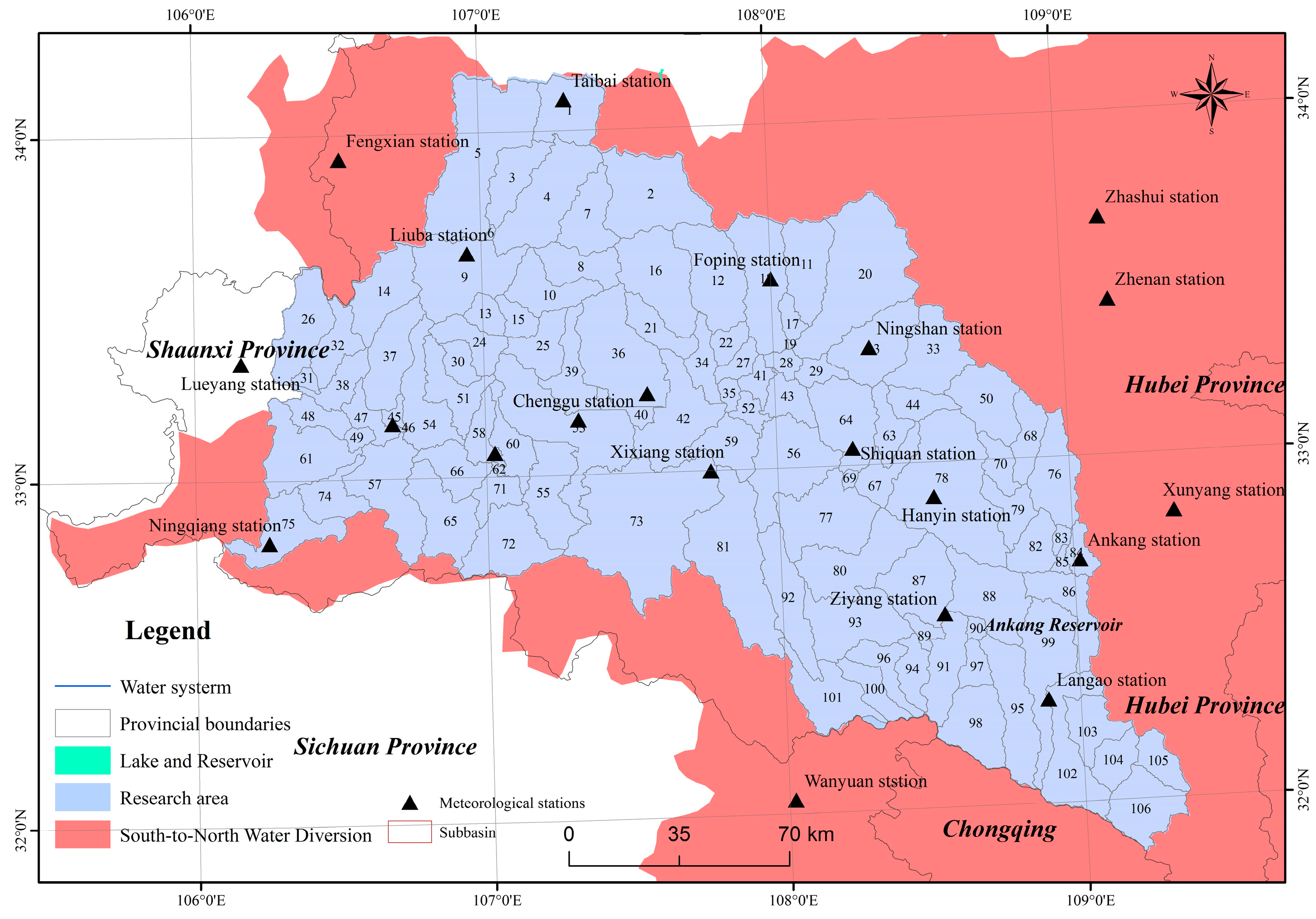
2.1. Study Area
2.2. Sources of Data
2.3. Data Input and Operation of the SWAT Model
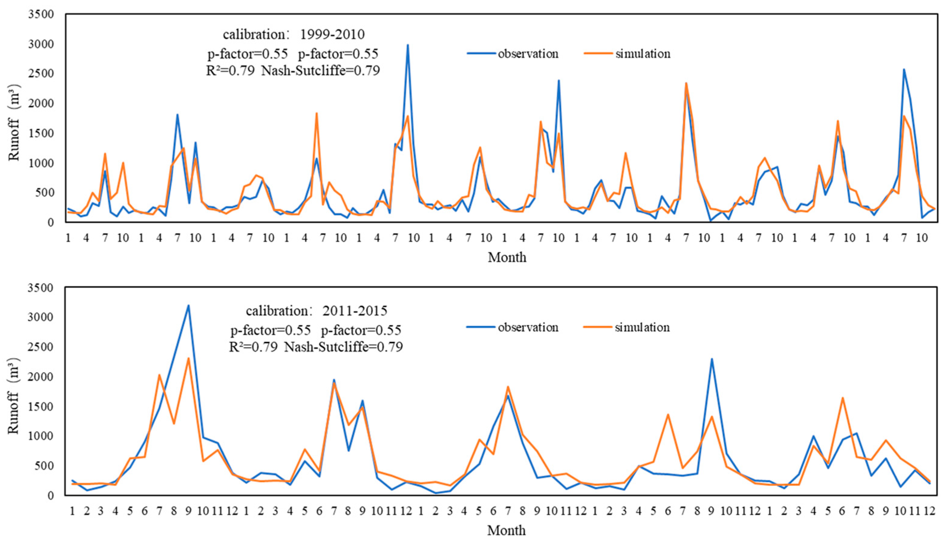
2.4. Calibration and Verification and Uncertainty Assessment
2.5. Water Demand Model
2.6. Self-Sufficiency Ratio of Ecosystem Services
3. Results
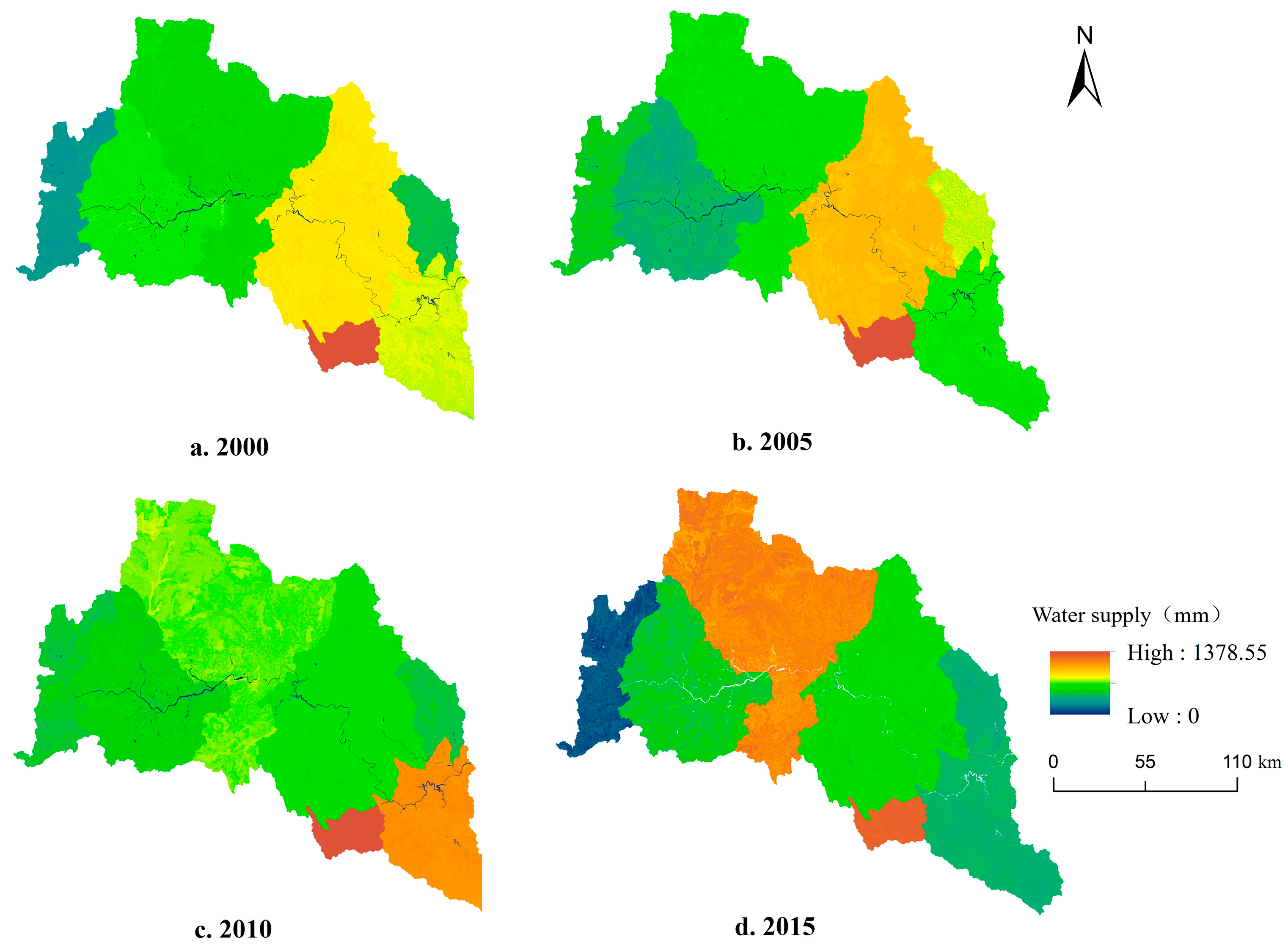
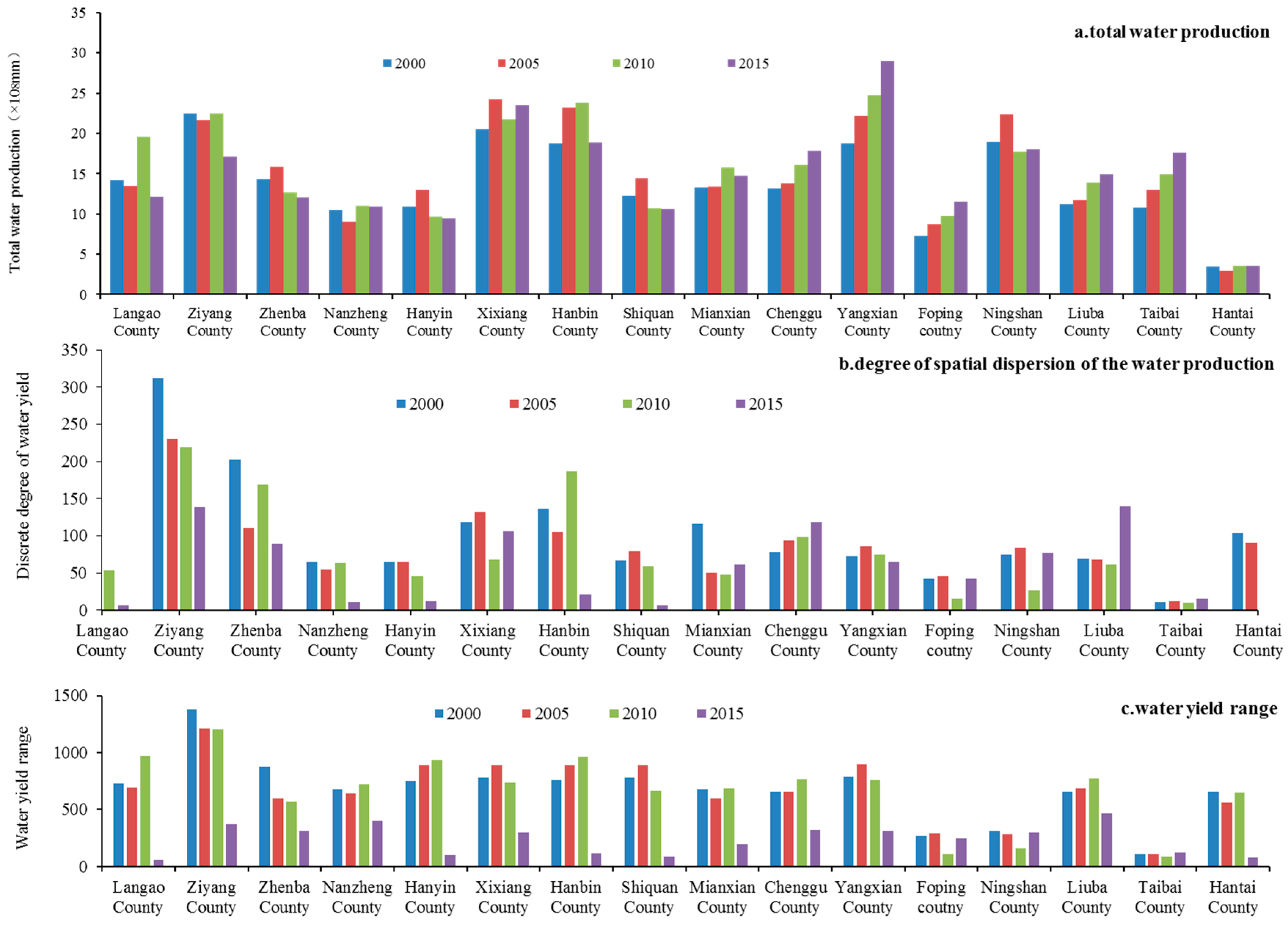
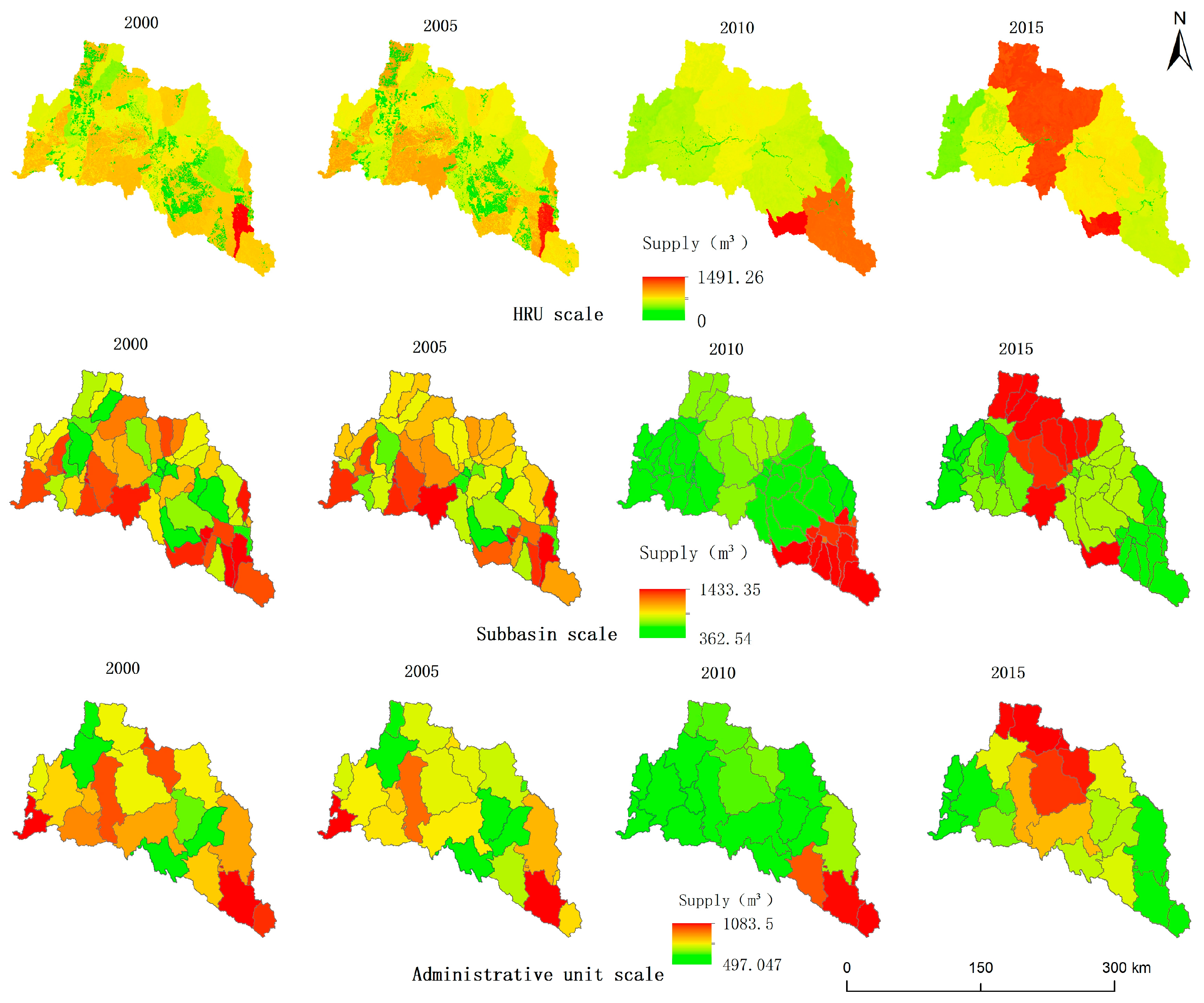
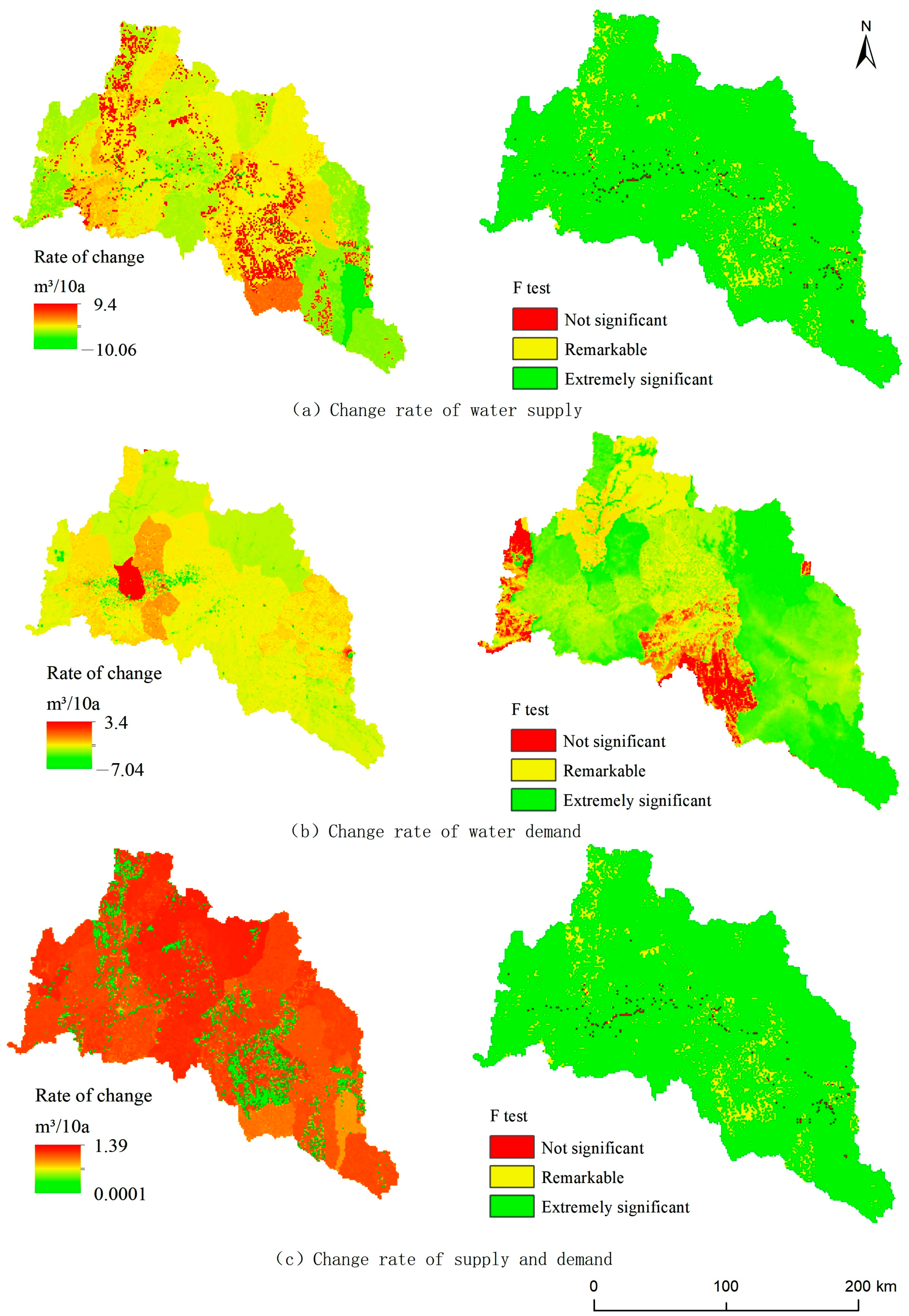
3.1. Spatial and Temporal Characteristics of Water Supply in the Upper Reaches of the Hanjiang River
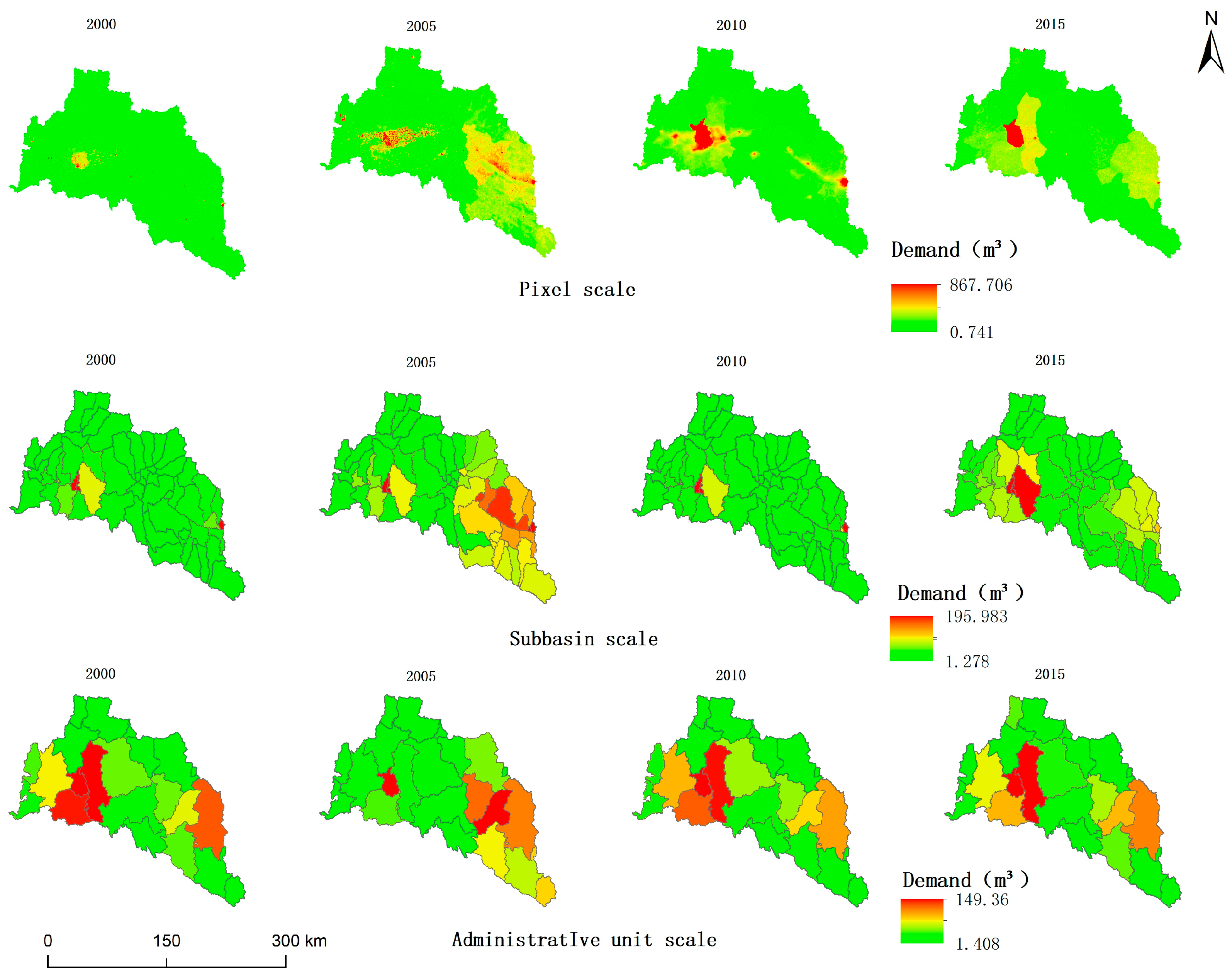
3.2. Spatial Distribution of Water Supply and Service Demand in the Upper Reaches of the Hanjiang River
3.3. Identification of the Water Supply Service Provision Zone and Benefit Zone in the Upper Reaches of the Hanjiang River
3.4. Spatial Characteristics of Water Resource Supply and Service Flow in the Upper Reaches of the Hanjiang River
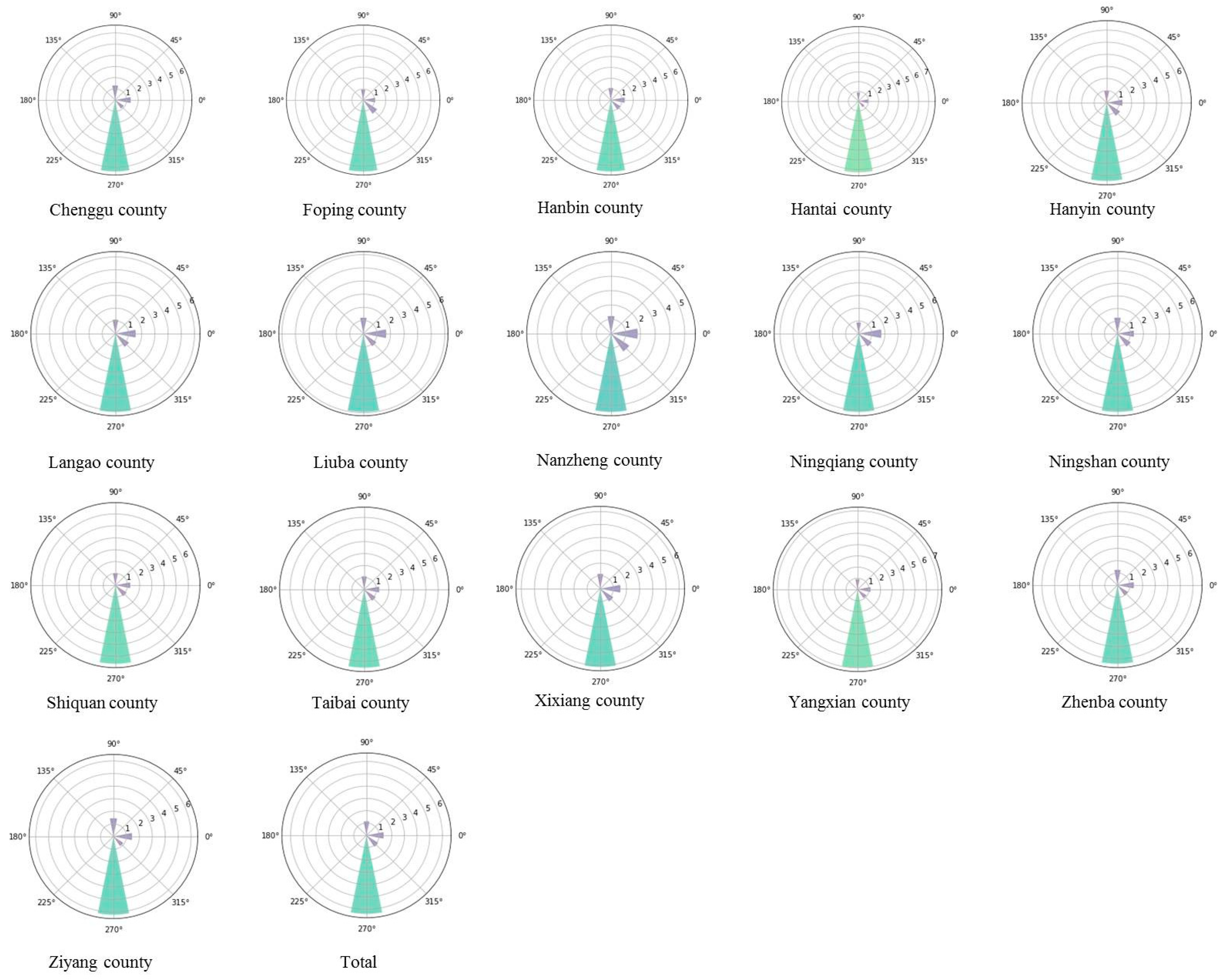
3.4.1. Flow Direction Analysis Based on the DEM
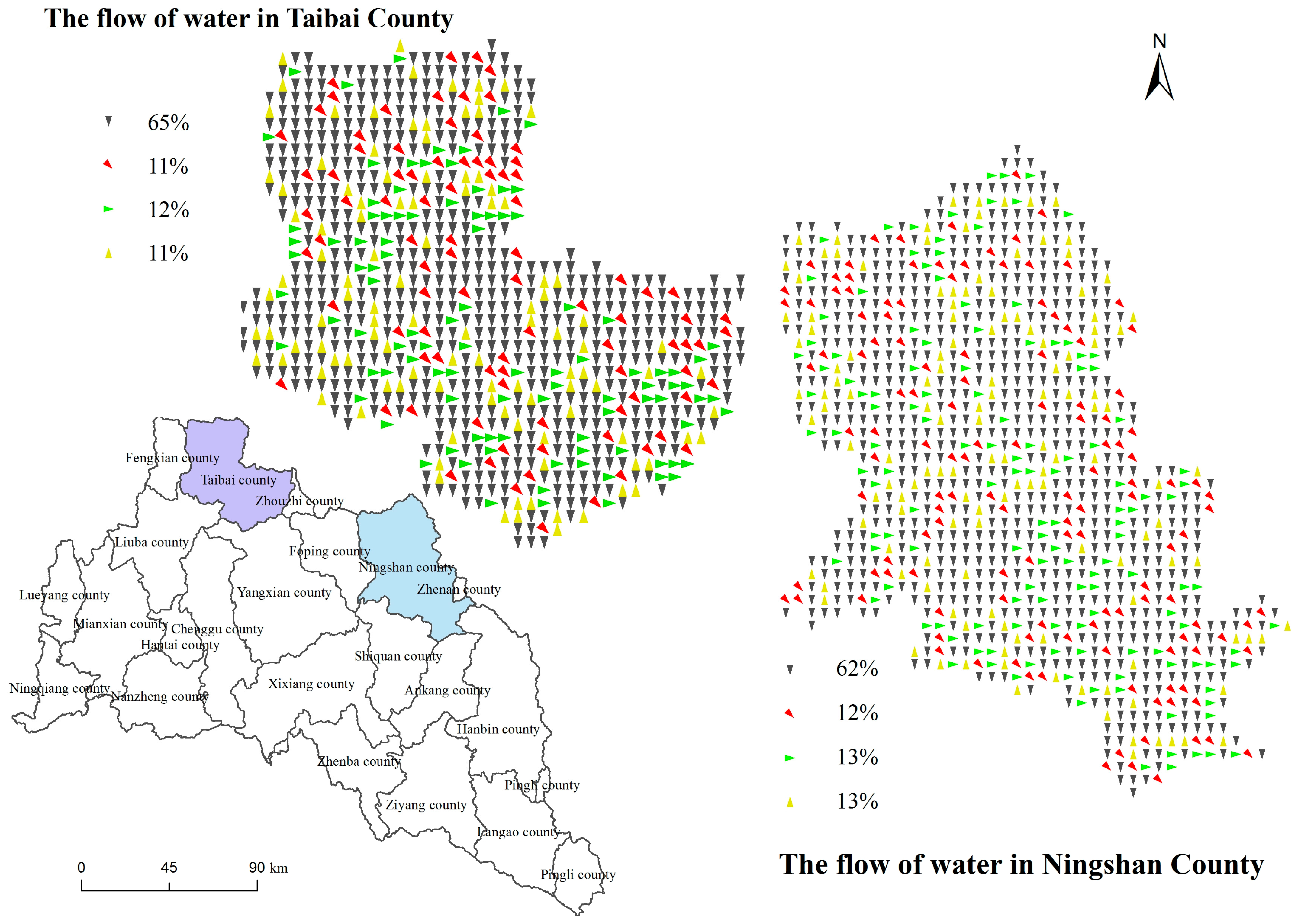
3.4.2. Water Supply Direction Based on Supply–Demand
4. Discussion
4.1. Challenges and Advantages
4.1.1. Temporal and Spatial Variations in Water Supply at the HRU Scale
4.1.2. Determining Flow Direction and Calculating Water Supply Based on the Self-Reliance Rate
4.1.3. Factors Influencing the Spatial Flow of Water Supply in the Upper Reaches of the Hanjiang River and Insights for Water Resources Management
4.1.4. Research on Water Supply Services Lays the Groundwork for the South-to-North Water Diversion Project
4.2. Uncertainty and Limitations
5. Conclusions
Author Contributions
Funding
Data Availability Statement
Acknowledgments
Conflicts of Interest
References
- Daily, G.C. Nature’s Services: Societal Dependence on Natural Ecosystems; Island Press: Washington, DC, USA, 1997; Volume 1, pp. 1–20. Available online: https://trove.nla.gov.au/work/16371608 (accessed on 16 January 2024).
- Costanza, R.; d’Arge, R.; de Groot, R.; Farber, S.; Grasso, M.; Hannon, B.; Limburg, K.; Naeem, S.; O’Neill, R.V.; Paruelo, J.; et al. The value of the world’s ecosystem services and natural capital. Nature 1997, 387, 253–260. [Google Scholar] [CrossRef]
- Bojie, W.; Qin, Z.; Fengqi, C. Scientific research on ecosystem services and human well-being: A bibliometric analysis. Ecol. Indic. 2021, 125, 107449. [Google Scholar] [CrossRef]
- Li, S.C.; Wang, J.; Zhu, W.B.; Zhang, J.; Liu, Y.; Gao, Y.; Wang, Y.; Li, Y. Geographical Framework of Ecosystem Services Based on Space and Regional Perspective. J. Geogr. 2014, 69, 1628–1639. [Google Scholar] [CrossRef]
- Datry, T.D.; Boulton, A.J.; Bonada, N.B. Flow intermittence and ecosystem services in rivers of the Anthropocene. J. Appl. Ecol. 2018, 55, 353–364. [Google Scholar] [CrossRef] [PubMed]
- De Brito, F.M.; Miraglia, M.S.; Semensatto, S. Ecosystem services of the Guarapiranga Reservoir watershed (So Paulo, Brazil): Value of water supply and implications for management strategies. Int. J. Urban Sustain. Dev. 2018, 22, 1–11. [Google Scholar] [CrossRef]
- Liwei, Z.; Bojie, F. Advances in mapping ecosystem services. J. Ecol. 2014, 34, 316–325. [Google Scholar] [CrossRef]
- Jiwei, W. Research on Ecosystem Service Function and Dynamic Evaluation of Upper Hanjiang River Based on Model. Master’s Thesis, Northwest University, Xi’an, China, 2014. [Google Scholar]
- Pengtao, W.; Liwei, Z.; Yingjie, L.; Lei, J.; Hao, W.; Junping, Y.; Yihe, L.; Bojie, F. Spatial and temporal characteristics of ecosystem services trade-offs and synergies in the upper reaches of the Hanjiang River. J. Geogr. 2017, 72, 2064–2078. [Google Scholar] [CrossRef]
- Kokkoris, I.P.; Drakou, D.; Evangelia, G.E.; Joachim, M.; Panayotis, D. Ecosystem services supply in protected mountains of Greece: Setting the baseline for conservation management. Int. J. Biodivers. Sci. Ecosyst. Serv. Manag. 2018, 14, 45–59. [Google Scholar] [CrossRef]
- Jing, T.; Shenglian, G.; Dedi, L.; Xingjun, H.; Shaokun, H. Multi-objective optimal allocation of water resources in the middle and lower reaches of the Hanjiang River. Water Resour. Res. 2018, 7, 223–235. [Google Scholar] [CrossRef]
- Le, W.; Shenglian, G.; Dedi, L.; Xingjun, H.; Mengyu, L.; Yukun, H. Virtual Water Trade Analysis of Hanjiang River Basin under Climate Change. Hydrology 2018, 38, 14–20. [Google Scholar] [CrossRef]
- Dengshuai, C. Study on the Supply-Demand Balance and Spatial Flow of Water Supply Services in Yanhe River Basin. Master’s Thesis, Shaanxi Normal University, Xi’an, China, 2018. [Google Scholar] [CrossRef]
- Hongjuan, G.; Guangpeng, C.; Xuqiang, L.; Hongjun, L. Analysis of Spatial and Temporal Change Characteristics of Freshwater Ecosystem Services in Wujiang River Basin. Wes. Es. Sci. 2016, 45, 6–12. [Google Scholar] [CrossRef]
- Jie, X.; Ying, X.; Gaodi, X.; Yuan, J. Ecosystem Service Flow Insights into Horizontal Ecological Compensation Standards for Water Resource: A Case Study in Dongjiang Lake Basin, China. Chin. Geogr. Sci. 2019, 29, 214–230. [Google Scholar]
- Zihan, X.; Weiguo, F.; Hejie, W.; Peng, Z.; Jiahui, R.; Zhicheng, G.; Sergio, U.; Weidong, K.; Xiaobin, D. Evaluation and simulation of the impact of land use change on ecosystem services based on a carbon flow model: A case study of the Manas River Basin of Xinjiang, China. Sci. Total Environ. 2019, 652, 117–133. [Google Scholar] [CrossRef]
- Mengdong, H.; Yu, X.; Jie, X.; Jingya, L.; Yangyang, W.; Shuang, G.; Shixuan, L.; Gaodi, X. A Review on the Supply-Demand Relationship and Spatial Flows of Ecosystem Services. J. Resour. Ecol. 2022, 13, 925–935. [Google Scholar] [CrossRef]
- Jeong, S.M.; Lee, J.H.; Ahn, J.K. Water Demand and Supply Stability Analysis Using Shared Vision Model. J. Korea Water Resour. Assoc. 2004, 37, 569–579. [Google Scholar] [CrossRef][Green Version]
- Cheng, Z.; Jing, L.; Zixiang, Z. Water Resources Security Pattern of the Weihe River Basin Based on Spatial Flow Model of Water Supply Service. Sci. Geogr. Sin. 2021, 41, 350–359. [Google Scholar] [CrossRef]
- Zhenda, Z. Valley Geomorphology between Danjiangkou and Baihe River in the Upper Reaches of the Han River. J. Geogr. 1955, 3, 259–271. [Google Scholar] [CrossRef]
- Binbin, J. Photoluminescence Dating and Climate Change of Sedimentary Strata in Lujiazhou Section, the Second Terrace of Upper Hanjiang River. Master’s Thesis, Shaanxi Normal University, Xi’an, China, 2018. [Google Scholar]
- Huan, C. Hydrological Effects of Climate and Land Use Change in the Upper Reaches of the Hanjiang River. Master’s Thesis, Shaanxi Normal University, Xi’an, China, 2018. [Google Scholar]
- Jiangli, P.; Chunchang, H.; Yli, Z.; Xiaochun, C.; Jing, Q. Diagnostic Fault Characteristics and Classification of Developed Soil in Yunxian County, Upper Reaches of the Han River. Acta Pedol. Sin. 2013, 50, 1082–1089. [Google Scholar] [CrossRef]
- Lv, L.; Wang, X.; Sun, C.; Zhang, J. Spatial and Temporal Distribution of Blue Water and Green Water Resources in the Xihe River Basin Based on SWAT Model. Res. Environ. Yangtze River Basin 2019, 28, 41–49. [Google Scholar] [CrossRef]
- Tripathi, M.P.; Panda, R.K.; Raghuwanshi, N.S. Identification and Prioritisation of Critical Sub-watersheds for Soil Conservation Management using the SWAT Model. Biosyst. Eng. 2003, 85, 365–379. [Google Scholar] [CrossRef]
- Yamini Priya, R.; Manjula, R. A review for comparing SWAT and SWAT coupled models and its applications. Mater. Today Proc. 2021, 45, 7190–7194. [Google Scholar] [CrossRef]
- Jing, J.; Tianxiao, M.; Yanru, L.; Xianfeng, S.; Runkui, L.; Junzhi, L.; Zheng, D. Multi-objective calibration and evaluation of SWAT modela case study in Meichuan River basin. J. Ucas. 2021, 38, 590–600. [Google Scholar]
- Mou, L.T.; Philip, W.G.; Xiaoying, Y.; James, H. A review of SWAT applications, performance and future needs for simulation of hydro-climatic extremes. Adv. Water Resour. 2020, 143, 103662. [Google Scholar] [CrossRef]
- Wenjuan, H.; Jie, G. Simulating runoff generation and its spatial correlation with environmental factors in Sancha River Basin: The southern source of the Wujiang River. J. Geogr. Sci. 2019, 29, 432–448. [Google Scholar] [CrossRef]
- Ren, Y.; Yang, C.; Chunhui, L.; Xuan, W.; Qiang, L. Hydrological Responses to Climate and Land Use Changes in a Watershed of the Loess Plateau, China. Sustainability 2019, 11, 11–21. [Google Scholar] [CrossRef]
- Pandi, D.; Kothandaraman, S.; Kuppusamy, M. Simulation of Water Balance Components Using SWAT Model at Sub Catchment Level. Sustainability 2023, 15, 1438. [Google Scholar] [CrossRef]
- Omid, R.; Mahmood, S.; Himan, S.; Ali, A.; Elham, R.; Hossein, A.; Assefa, M.M.; Biswajeet, P.; Kamran, C.; Ataollah, S. SWPT: An automated GIS-based tool for prioritization of sub-watersheds based on morphometric and topo-hydrological factors. Geosci. Front. 2019, 10, 2167–2175. [Google Scholar] [CrossRef]
- Tufa, F.G.; Sime, C.H. Stream flow modeling using SWAT model and the model performance evaluation in Toba sub-watershed, Ethiopia. Model. Earth Syst. Environ. 2021, 7, 2653–2665. [Google Scholar] [CrossRef]
- Jie, Z.; Ning, Z.; Zhuochen, L.; Qing, Z.; Chengwei, S. SWAT model applications: From hydrological processes to ecosystem services. Sci. Total Environ. 2024, 931, 172605. [Google Scholar] [CrossRef]
- Anthony, L.; Pablo, T.; Marc, F.; Martin, L.; Saeid, A.V.; Karim, C.A. SWATCH21: A project for linking eco-hydrologic processes and services to aquatic biodiversity at river and catchment levels. Ecohydrol. Hydrobiol. 2019, 19, 182–197. [Google Scholar] [CrossRef]
- Guodong, W.; Yanxin, W.; Jianfeng, T. Study on Ecological Compensation Mechanism for Water Source Area of Middle Route Project of South-to-North Water Transfer. People’s Yangtze. River. 2012, 43, 89–93. [Google Scholar]
- Yu, T.; Xianfang, S.; Ying, M. Study on Water Resources Value of South-to-North Water Transfer Receiving Area Based on Optimal Allocation. South–North Water Transf. Water Sci. Technol. 2018, 16, 189–194. [Google Scholar] [CrossRef]
- Jiulong, Z.; Jun, W.; Xiaoyan, T. Study on the allocation of ecological compensation funds in the water source area of the middle route of South-to-North Water Transfer Project based on the value of ecological services. Eco-Economy 2017, 33, 127–132. [Google Scholar]
- Jiulong, Z. Study on priority coefficient of ecological compensation in water source area of the Middle Route Project of South-to-North Water Transfer. Hyd. Ene. Sci. 2017, 22, 113–116. [Google Scholar]
- Chen, Z.; Xiaohui, D.; Guoping, L.; Haizhou, W. Study on Ecological Compensation Standards for Water Source Area of the Middle Route Project of South-to-North Water Transfer—From the Perspective of Ecosystem Service Value. Res. Sci. 2015, 37, 792–804. [Google Scholar]
- Xuesong, L.; Tingting, L. Study on market-oriented ecological compensation mechanism for water source area of the Middle Route Project of South-to-North Water Transfer. Res. Environ. Yangtze. River Basin 2014, 23, 66–72. [Google Scholar] [CrossRef]
- Yu, W.; Jianmin, B.; Yongsheng, Z.; Jie, T.; Zhuo, J. Assessment of future climate change impacts on nonpoint source pollution in snowmelt period for a cold area using SWAT. Sci. Rep. 2018, 8, 33–45. [Google Scholar] [CrossRef]
- Pengwei, Q.; Mei, L.; Sucai, Y.; Jun, Y.; Xiaoyong, Z.; Nan, D.; Guanghui, G. Development of a model to simulate soil heavy metals lateral migration quantity based on SWAT in Huanjiang watershed, China. J. Environ. Sci. 2018, 77, 118–132. [Google Scholar] [CrossRef]







| Serial Number | Parameter Name | Definition | Lower Limit | Upper Limit | Calibration Value |
|---|---|---|---|---|---|
| 1 | r__CN2.mgt | Runoff curve | −0.2 | 0.2 | −0.08 |
| 2 | v__ALPHA_BF.gw | Base flow regression coefficient | 0.0 | 1.0 | 0.7 |
| 3 | v__GW_DELAY.gw | Groundwater delay coefficient | 30 | 450 | 240 |
| 4 | v__GWQMN.gw | Threshold of water level generated by basic flow | 0.0 | 2.0 | 1.0 |
| 5 | v__CH_N2.rte | Manning coefficient of main channel | 0.0 | 0.3 | 0.19 |
| 6 | v__CH_K2.rte | Effective hydraulic conductivity of main channel | 0 | 3500 | 2000 |
| 7 | SURLAG | Surface runoff hysteresis coefficient | −0.8 | 0.8 | 0.5 |
| 8 | LAT_TTIME | Running time of interflow in soil | 0 | 100 | 5 |
| Land Use Types | Corresponding Water Use Classification |
|---|---|
| Cultivated land | Water to irrigate paddy fields and other agricultural areas |
| Woodland | Water to irrigate orchards and other types of trees |
| Grassland | Water to irrigate grasslands, shrubs, etc. |
| Water | Fishery cultivation |
| Land used for building | Water for domestic use and industrial production in urban and rural areas |
| Unused land | Unallocated |
Disclaimer/Publisher’s Note: The statements, opinions and data contained in all publications are solely those of the individual author(s) and contributor(s) and not of MDPI and/or the editor(s). MDPI and/or the editor(s) disclaim responsibility for any injury to people or property resulting from any ideas, methods, instructions or products referred to in the content. |
© 2024 by the authors. Licensee MDPI, Basel, Switzerland. This article is an open access article distributed under the terms and conditions of the Creative Commons Attribution (CC BY) license (https://creativecommons.org/licenses/by/4.0/).
Share and Cite
Ma, X.; Li, J.; Yu, Y. A Study on the Determination and Spatial Flow of Multi-Scale Watershed Water Resource Supply and Benefit Areas. Water 2024, 16, 2461. https://doi.org/10.3390/w16172461
Ma X, Li J, Yu Y. A Study on the Determination and Spatial Flow of Multi-Scale Watershed Water Resource Supply and Benefit Areas. Water. 2024; 16(17):2461. https://doi.org/10.3390/w16172461
Chicago/Turabian StyleMa, Xinping, Jing Li, and Yuyang Yu. 2024. "A Study on the Determination and Spatial Flow of Multi-Scale Watershed Water Resource Supply and Benefit Areas" Water 16, no. 17: 2461. https://doi.org/10.3390/w16172461
APA StyleMa, X., Li, J., & Yu, Y. (2024). A Study on the Determination and Spatial Flow of Multi-Scale Watershed Water Resource Supply and Benefit Areas. Water, 16(17), 2461. https://doi.org/10.3390/w16172461


