Article

Scenario-Based Modeling on Chlorophyll-a in Uiam Reservoir of Korea According to Variation of Dam Discharge

Department of Civil and Environmental Engineering, Hankyong National University, Anseong-si 17579, Gyeonggi Province, Republic of Korea
*
Author to whom correspondence should be addressed.
Water 2024, 16(15), 2120; https://doi.org/10.3390/w16152120
Submission received: 27 June 2024 / Revised: 24 July 2024 / Accepted: 24 July 2024 / Published: 26 July 2024
(This article belongs to the Special Issue Contaminant Transport Modeling in Aquatic Environments)

Abstract

:
This study analyzes quantitative algae mitigation, using chlorophyll-a as an indicator, through waterbody management techniques such as pulses released from upstream dams, employing a three-dimensional numerical model. Numerical simulations focused on algae reduction through dam operations by investigating nine scenarios based on Chuncheon Dam, Soyang Dam, and Uiam Dam, located in the upper and lower reaches of Uiam Reservoir of Korea. These scenarios, aligned with actual dam operation manuals, aimed to differentiate the impact of each dam’s operation by decreasing water residence time for Uiam Reservoir. The Uiam Reservoir, smaller than the upstream Chuncheon Dam and Soyang River Dam, is significantly influenced by their discharge rates. During summer, temperature differences exceeding 7 °C between discharges from Chuncheon Dam and Soyang Dam inflowed into the right side and the left side, respectively, of the reservoir, leading to poor mixing, which was further hindered by islands within the reservoir. Consequently, due to the influence of the different base water temperatures of the Bukhan River and Soyang River and the topographical characteristics, the impact range varied depending on the operation of each dam, and the amount of algae mitigation differed at each point. In emergency situations where algae blooms proliferate rapidly, appropriate dam operations in water bodies with large dams upstream and downstream, like Uiam Reservoir, can be effective in mitigating algae at specific regions of the reservoir.

1. Introduction

Harmful algal blooms (HABs) have emerged as a significant global environmental concern, coinciding with the broader context of global climate change. These blooms can have severe ecological and public health impacts [1,2]. Multiple cases of harm to the human body, including poisoning, resulting from exposure to toxins produced during algae blooms have been documented in the literature [3,4,5,6,7,8].
The International Agency for Research on Cancer (IARC) has identified microcystin-LR (MC-LR), a prominent toxin produced by harmful algae, as a carcinogen capable of causing liver cancer [9]. Furthermore, prolonged exposure to low doses of microcystin toxins has been shown to impair male reproductive function in laboratory rats [10].
Large algal blooms can disrupt aquatic ecosystems by blocking sunlight, harming submerged aquatic vegetation and the organisms that rely on them [11]. Excessive algal growth can lead to the creation of dead zones, areas with low or no oxygen, where aquatic life cannot survive [12]. One notable real-world example of HABs is Lake Erie in the United States, where repeated algal blooms have garnered significant attention due to their environmental, economic, and public health impacts. The phenomenon of HABs is increasingly prevalent worldwide, prompting various studies on the causes and damage associated with algal growth. Codd et al. [13] and Lehman et al. [14] suggested that toxicity was induced by algae. Joh and Lee [15] raised concerns about filter clogging in rapid filtration processes caused by algae. Dencheva [16] highlighted aesthetic landscape degradation due to algal occurrences near rivers and lakeshores. Due to water quality deterioration, Huh et al. [17] conducted research on discharge systems and technological applications related to water quality improvement. Kim et al. [18] investigated the likelihood of algal occurrence in lakes formed by dams.
Persistent algae issues have been observed in the Uiam Reservoir, the focus of this research. Uiam Reservoir is located between Chuncheon Dam and Soyang Dam upstream and Uiam Dam downstream, as illustrated in Figure 1. To address harmful algal blooms that lead to toxin production, foul odors, and aesthetic concerns, two primary approaches are available: waterbody management and watershed management. Waterbody management techniques include flushing, chemical treatments to control blooms, and the use of biological agents. In the case of watershed management, this entails the integrated management of water quantity and quality, along with advanced sewage and wastewater treatment to reduce nutrient input [19]. However, each watershed exhibits distinct environmental characteristics, encompassing not only water quality but also economic, social, and technological aspects. Consequently, a one-size-fits-all solution is not applicable to all watersheds, necessitating comprehensive measures rooted in research on the specific watershed and its water environment. Understanding the causes of HABs and exploring effective mitigation strategies are crucial to addressing the challenges they pose. These blooms occur due to rapid algae proliferation influenced by factors such as nutrient levels, water temperature, and residence time [20]. Huang et al. [21] conducted research on how reservoir water residence time influences cyanobacteria and cyanotoxin dynamics. In addition, research has been conducted on the growth characteristics of algae in reservoirs in relation to nutrient load and residence time [22,23,24,25]. Kim et al. [26] proposed an alternative to reducing algae blooms through the oscillatory discharge of dams to create irregular flows.
This study quantitatively analyzes the mitigation of algae (through the replacement of indicators with chlorophyll-a) through waterbody management using the three-dimensional numerical model, the Environmental Fluid Dynamics Code (EFDC). Waterbody management assesses algae reduction through dam operation. This study investigated nine dam operation scenarios based on Chuncheon Dam, Soyang Dam, and Uiam Dam located in the upper and lower reaches of Uiam Reservoir, the study area. These scenarios aligned with actual dam operation manuals and aimed to differentiate the impact of the operation of three dams on Uiam Reservoir. This process can help reduce HABs by decreasing the residence time of the water.
The EFDC model was initially developed at the Virginia Marine Science Laboratory in the early 1990s and is currently being developed and maintained by the U.S. Environmental Protection Agency (EPA) and Tetra Tech, Inc. The EFDC model is widely used to analyze hydraulic and water quality behavior in lakes and rivers. In this study, the publicly available EFDC model was used [27]. Past studies have employed the EFDC model for various water-related investigations, including the hydrological impacts of dam construction, Chl-a concentration simulations, and analyses of water quality uncertainty. Jang et al. [28] used the EFDC model to analyze the effects of oil contaminant movement and diffusion. Cunanan and Salvacion [29] used the EFDC model to simulate the Laguna Reservoir in the Philippines for a hydrological analysis of dam construction. Anderson [30] employed the EFDC model to study pumped hydropower operation effects on water temperature stratification and mixing in the Elsinore Reservoir. Wang et al. [31] used the EFDC model to investigate the hydrological impact of dam construction between Lake Poyang and the Yangtze River. Lee et al. [32] used EFDC to analyze upstream algae concentration changes concerning dam operation. The EFDC model was also used to analyze the impact of upstream dam discharge on water quality changes in the downstream section [33,34]. Wu and Xu [35] employed the EFDC model to simulate chlorophyll-a (Chl-a) concentration, crucial in predicting algae due to their close correlation. Franceschini and Tsai [36] used the EFDC model to evaluate water quality uncertainty sources in the Niagara River. Li et al. [37] conducted a study on dissolved substance movement in a lake using the EFDC model.

2. Methodology

2.1. Feature of Study Area

As mentioned in Section 1, this study focused on the Bukhan River, stretching from Uiam Dam to Chuncheon Dam in South Korea, and the Soyang River, a tributary of the Bukhan River that includes the Soyang Dam. Figure 1 illustrates the confluence of the Soyang River with the Bukhan River, approximately 8.5 km upstream of Uiam Dam, with Soyang Dam situated approximately 11 km upstream from this confluence point. The chosen area also experiences ongoing issues with harmful algae and has available data for model calibration, including water level and water quality measurements.
The catchment area of the Uiam Dam is 7709 km2 and the average depth of Uiam Reservoir is about 5 m, making it a relatively shallow reservoir. The annual average inflow rate in 2013 was 206 m3/s, resulting in an annual mean hydraulic residence time of 4.5 days [38]. The storage capacity of Uiam Dam is 80 million m3, which is significantly smaller than the storage capacity of Hwacheon Dam (1000 million m3) and Soyang Dam (3000 million m3), both of which are located upstream of Uiam Dam. Therefore, in water bodies like Uiam Reservoir, where large dams are present upstream, both main stream and tributary, it is possible to expect a reduction in algal blooms during emergency situations through the adjustment of hydraulic residence time as part of dam operations. Soyang Dam is a multi-purpose dam built for flood control and power generation. For hydroelectric power generation, a water channel is constructed near the middle of the dam, utilizing a rated head of 90 m to produce 353 GWh of electricity per year. The maximum depth of Soyang Reservoir is 118 m, with an average depth of 34 m [39]. In Soyang Reservoir, a thermocline layer that maintains a stable temperature of around 4 degrees Celsius develops at a water depth of around 20 m in the summer [40]. Because water with a low temperature from deep water is discharged, the water temperature of the Soyang River discharged from Soyang Dam is about 7 °C lower than that of the Bukhan River discharged from Chuncheon Dam. At the confluence point of the Bukhan River and Soyang River lies an island housing Legoland, attracting numerous tourists. Additionally, Uiam Reservoir is situated upstream of Paldang Reservoir, a vital water source for 20 million metropolitan area residents. Consequently, the local government is actively pursuing various measures, such as water quality improvement projects, to mitigate HABs in the Uiam Reservoir. The local government implemented a non-point pollution reduction project that included installing islands of artificial aquatic vegetation to reduce algae and storage facilities to block pollutants entering the river, at a cost of approximately USD 9 million. Soyang Reservoir, located upstream of Soyang Dam, is a massive reservoir with a total storage capacity of approximately 2900 million m3. The catchment area of the Soyang Dam is 7709 km2 and the reservoir area is 70 km2. Despite its size, water quality observations are not routinely conducted on the inflowing tributaries.
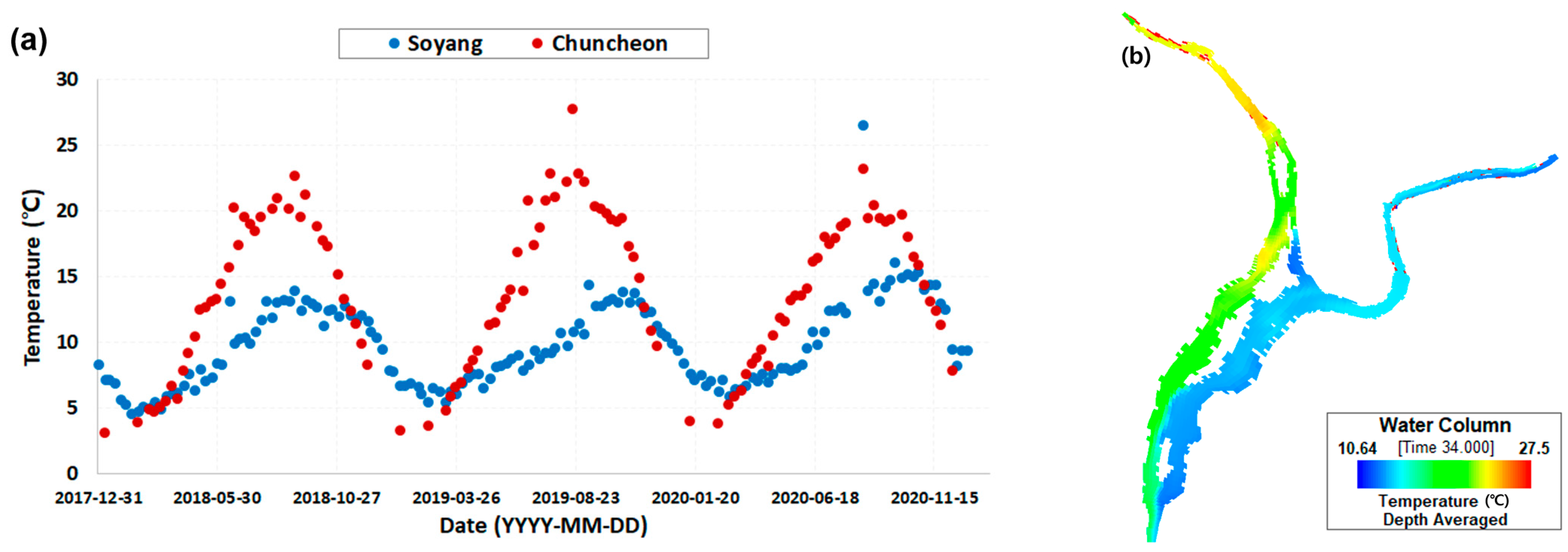
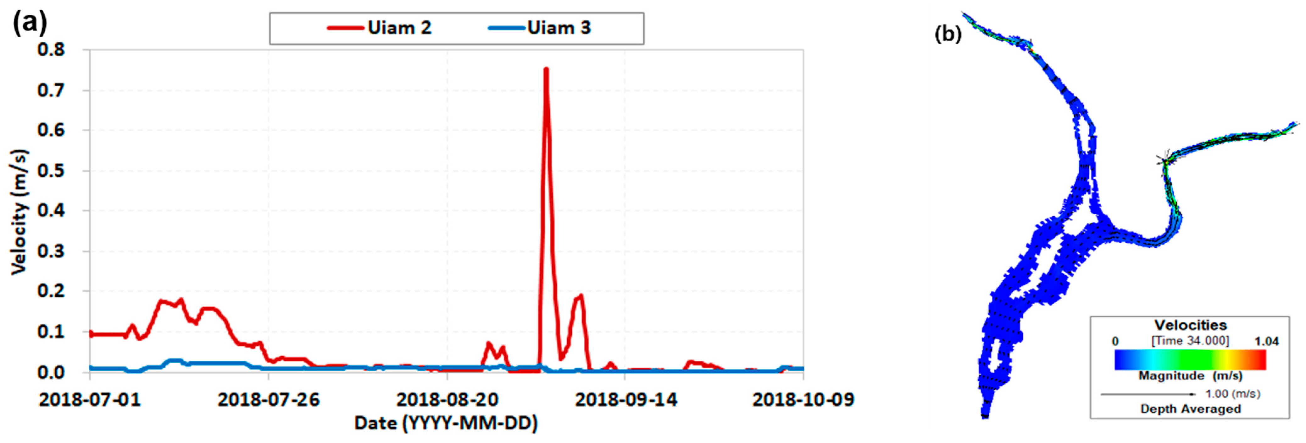
This area has distinctive geographical and temperature characteristics. Notably, Jungdo Island is located at the center of Uiam Reservoir, and the Soyang River, a significant tributary, flows in from the left side. This configuration results in variations in water temperature between the right and left sides of Uiam Reservoir. During summer, the downstream water temperature at Chuncheon Dam, the main stream of the Bukhan River, is approximately 7 °C higher than the temperature downstream of Soyang Dam, a tributary. Figure 2a presents time-series data of water temperature measured directly downstream of Chuncheon Dam (at Chuncheon 1, as shown in Figure 1) and Soyang Dam (at Soyang River 2, as shown in Figure 1) over a span of three years, from 2018 to 2020. These differences in base water temperature significantly influence the local water environment, and these water temperature characteristics were accurately simulated in the constructed EFDC model, as depicted in Figure 2b, showing the water temperature simulation result by the EFDC model for the study area on 30 July 2018. As shown in Figure 2b, Jungdo Island (in the satellite map in Figure 1) located within Uiam Reservoir was well represented in the EFDC. Figure 3 shows the flow velocity simulated by the EFDC, illustrating the hydraulic characteristics within Uiam Reservoir. Figure 3a presents the EFDC flow velocity simulation results from July to October 2018 at Uiam 2 and Uiam 3. Figure 3b shows the flow velocity results for the study area as of 30 July 2018. The velocity in Uiam Reservoir is influenced by the discharge amount from the upstream dam. In this figure, the velocity at Uiam 2 (WQS in Figure 1) is faster than that at Uiam 3 due to the influence of Chuncheon Dam, which has a large discharge volume overall.

2.2. Construction of Numerical Model

Hydrodynamics and water quality were comprehensively simulated for various water environmental variables using the EFDC model for the study area. Accurate water surface grid construction in the EFDC model was crucial for the effective simulation of various water environment aspects. In this study, the basic plan of the study area and satellite images were integrated to construct a water surface grid with important features, such as actual cross-section width, river bed height distribution, and the precise location of hydraulic structures. The EFDC model encompassed a total length of approximately 91 km, a basin area of about 5510 ha, and a total of 2350 grid points. The average grid size in the width direction was around 183 m and the average grid size in the flow direction was about 130 m.
Figure 1 shows the main observation points utilized in this study, including water surface elevation stations (WESs) and water quality stations (WQSs). WES data were sourced from the National Water Resources Management Integrated Information System (WAMIS) and measured at daily intervals [41]. WQS data, on the other hand, were obtained from the Water Environment Information System and measured at monthly or weekly intervals [42]. WQS Uiam 1 provided water quality measurements (DO, TP, TOC, Chl-a, and water temperature) four times a month. Other WQS stations (Uiam 2 and Uiam 3) provided water quality measurements only once a month. The inlet boundary values required for the EFDC hydrodynamic model were derived from the flow rates of Chuncheon Dam (Figure 4a) and Soyang Dam (Figure 4b). For the outlet boundary values, the water level of Uiam Dam (Figure 4c) was used.

2.3. Model Calibration and Verification

Given the deep water depth in the reservoir area, it was necessary to examine algal concentrations by depth due to stratification phenomena. The EFDC model uses a sigma (stretched) vertical coordinate system with a Cartesian or curvilinear horizontal coordinate grid [27,30]. In this study, the sigma coordinate approach was applied, which used the same number of vertical layers throughout the model domain regardless of water depth. Consequently, the EFDC model was divided into three layers evenly in the water depth direction to analyze algal concentration by depth. The results, as shown in Figure 5, showed a slight deviation in Chl-a concentration only at points directly upstream (WQS Uiam 1) of the dam, where the water depth was deep. However, no significant difference in concentration by depth was observed at other points with relatively shallow water depths.
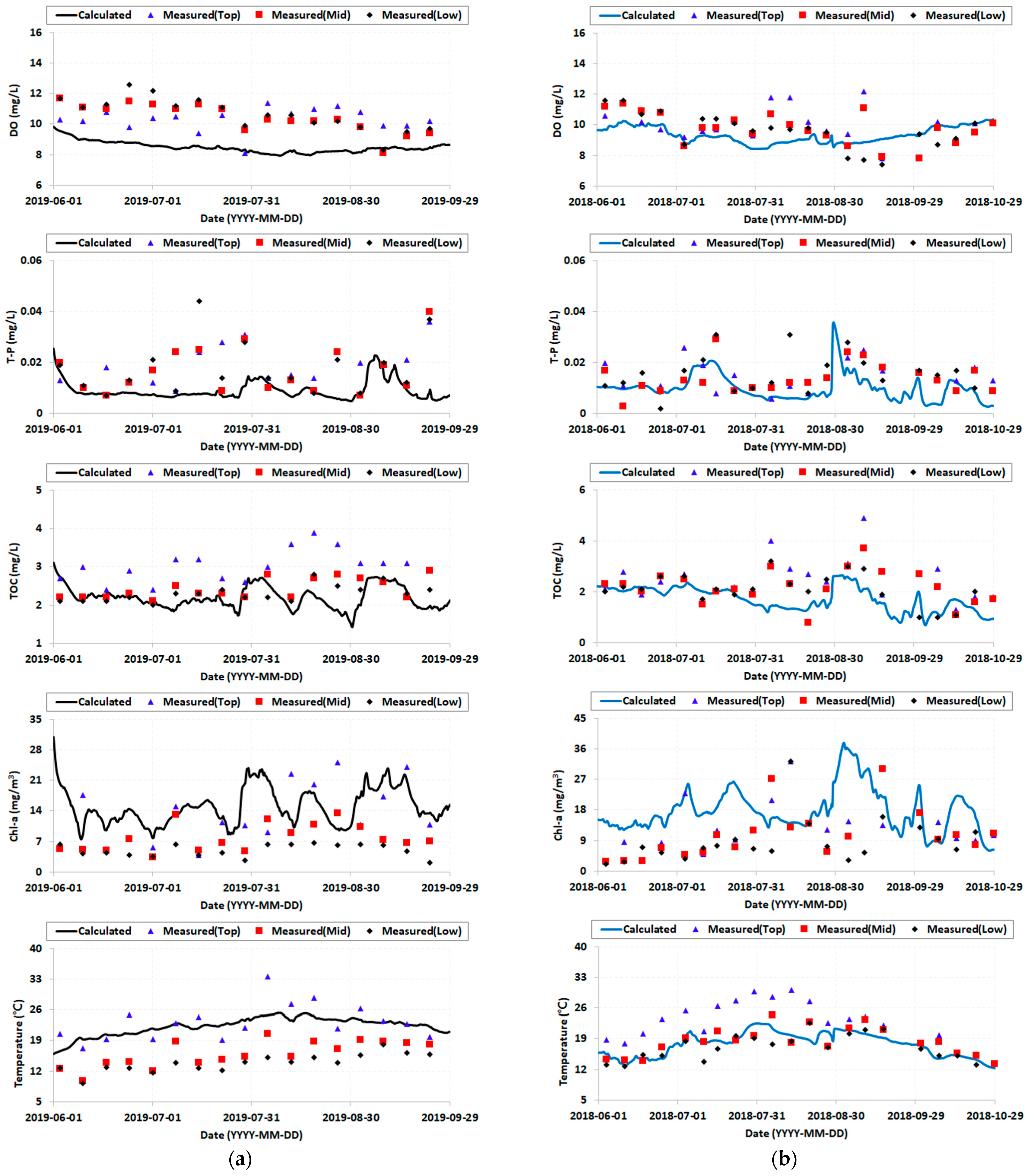
The EFDC model’s accuracy for hydrodynamics and water quality was evaluated by comparing measured values from observatory stations with calculated values from the model at the same locations. The EFDC water quality model utilized 22 water quality variables. The values of these 22 variables were determined and used by applying the ratios presented in the literature to the measured values of DO, TP, TOC, TN, and Chl-a. A schematic diagram of the interactions between the 22 water quality variables can be found in [43]. Hydrodynamics was verified using water elevation values, while water quality was verified using five key indicators: dissolved oxygen (DO), total phosphorus (T-P), total organic carbon (TOC), Chl-a, and water temperature. Model calibration was conducted based on the data from 1 June to 30 September 2019 and the validation was conducted using data from 1 June to 30 October 2018, specifically during the summer months when algae blooms were most severe. Several evaluation metrics were used to verify the model’s accuracy, including the coefficient of determination (R2) for the hydraulic model and percentage bias (PBIAS) and root mean square error (RMSE) for the water quality model. The R2, PBIAS, and RMSE equations were Equations (1)–(3), respectively. The indices of differences between the observed and calculated data are shown in Table 1. In the case of PBIAS, reliability was evaluated based on the range in which the index was located.
R 2 = i = 1 n ( O i P i ) 2 i = 1 n ( O i O ¯ ) 2
P B I A S = i = 1 n O i P i × 100 i = 1 n O i
R M S E = i = 1 n ( P i O i ) 2 n
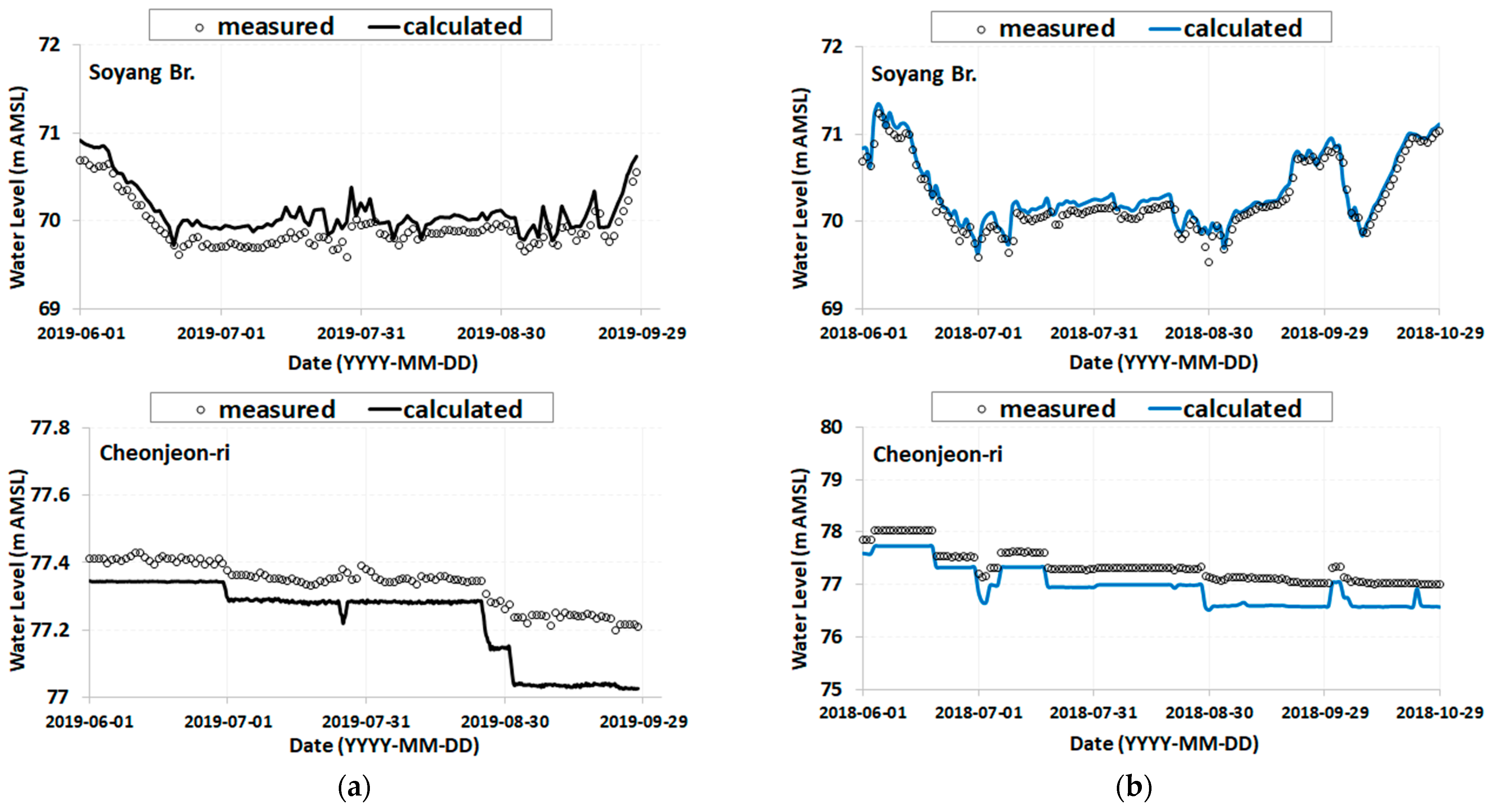
The calibration and validation results for the hydrodynamics model, especially water level, are shown in Figure 6. After calibration, the water level between measured and calculated data exhibited an R2 value of 0.87 at the WES Soyang Bridge, positioned on the main stream of the Bukhan River, indicating good accuracy. At the WES Cheonjeon-ri, located on the primary stream of the Soyang River, an R2 value of 0.93 was calculated, signifying strong accuracy. Upon validation, the hydrodynamics model continued to demonstrate high accuracy. At the WES Soyang Bridge on the Bukhan River’s primary stream, an R2 value of 0.96 underscored its good accuracy. Downstream of the Soyang Dam, at the WES Cheonjeon-ri, the R2 value stood at 0.96, again reflecting good accuracy. The consistency of R2 values exceeding 95% across various locations and conditions underscored the model’s exceptional accuracy.
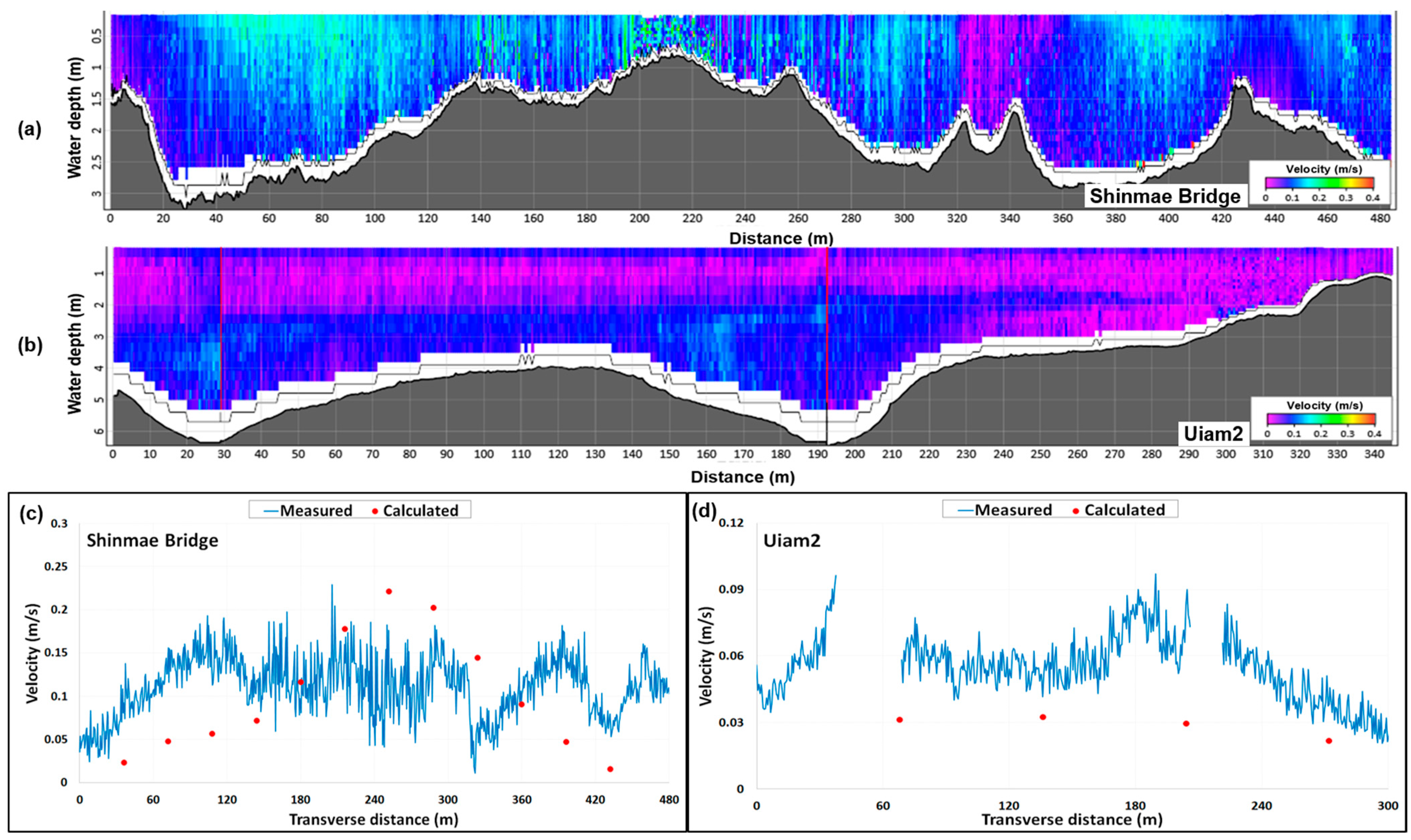
In order to verify the hydrodynamics model for the flow velocity, three-dimensional velocity data at two cross-sections (one was at Uiam 2 and the other was at the cross-section where the Bukhan River flows into Uiam Reservoir (Shinmae Bridge shown in Figure 1)) were acquired by using ADCP (Acoustic Doppler Current Profiler) in this study. The three-dimensional velocity fields at Shinmae Bridge and Uiam 2 are shown in Figure 7a,b. When the velocity measurement was conducted, the discharge from Chuncheon Dam at that time was 85 m3/s. The same flow rate condition from Chuncheon Dam was selected in the EFDC results, and the measured velocity was compared with the calculated one. The depth-averaged point velocities across the channel width were compared with each other and are depicted in Figure 7c,d. As shown in this figure, the velocities between measured and calculated data were in good agreement with each other. The PBIAS at the Shinmae Bridge was 7.129, which was considered “very good” [44] (as shown in Table 1), and the RMSE was 0.069. The PBIAS at Uiam 2 was 48.019, which was considered “satisfactory” (as shown in Table 1), and the RMSE was 0.031.
The study area comprised Uiam Reservoir upstream of Uiam Dam. Therefore, the water quality model was calibrated and verified using data from WQS Uiam 1, located directly upstream of Uiam Dam. WQS Uiam 1 provided water quality values approximately every 7 days and was classified into upper, middle, and lower layers depending on water depth. Figure 8 shows the calibration and validation results at WQS Uiam 1. PBIAS and RMSE were used to evaluate the performance of the calibration and validation of the water quality model. The results are summarized in Table 2. The validation evaluation for Chl-a showed a PBIAS of 61.74, which was within the “satisfactory” range (as shown in Table 1). T-P and TOC results were classified as “good” and DO and temperature results were considered “very good”.

2.4. Scenarios of Dam Operation

In this study, variations in Chl-a concentration according to water body management by dam operation were quantitatively analyzed. This study designed and simulated a total of nine scenarios for analysis, each aimed at evaluating the impact of specific dam operations within Uiam Reservoir under various discharge conditions. The scenarios involved selecting discharge rates of 0 m3/s, 30 m3/s, and 50 m3/s for the Soyang Dam, which is a tributary, and discharge rates of 250 m3/s and 212 m3/s for the Chuncheon Dam, located upstream in the main stream. To investigate the impact of Uiam Dam located downstream of the main stream, two conditions were considered: 1 m and 0.5 m reduction in water level in Uiam Reservoir due to the discharge of Uiam Dam. These dam operation scenario conditions were designed with reference to the planned discharge amounts according to the actual water levels of each dam to best reflect the reality of dam operation management. These carefully designed scenarios are summarized in Table 3.

3. Results and Discussion

3.1. Results of Dam Operation

First of all, it must be observed that the velocity and residence time were changed due to dam operation. Figure 9 shows the changes in flow rate from the upstream dam applied in the Pulse_A.3 scenario and the resulting changes in velocity at Uiam 2 and Uiam 3. Figure 9 helps determine how the relative increase in flow rate affected the water residence time in Uiam Reservoir. Figure 9 shows the changing flow rate and velocity when applying the scenario corresponding to Pulse A_3. In the case of Uiam 2 (Figure 9a), the flow velocity increased approximately four-fold, from an average of 0.08 m/s to 0.31 m/s. As a result, the residence time decreased from 2.6 days to 0.7 days.
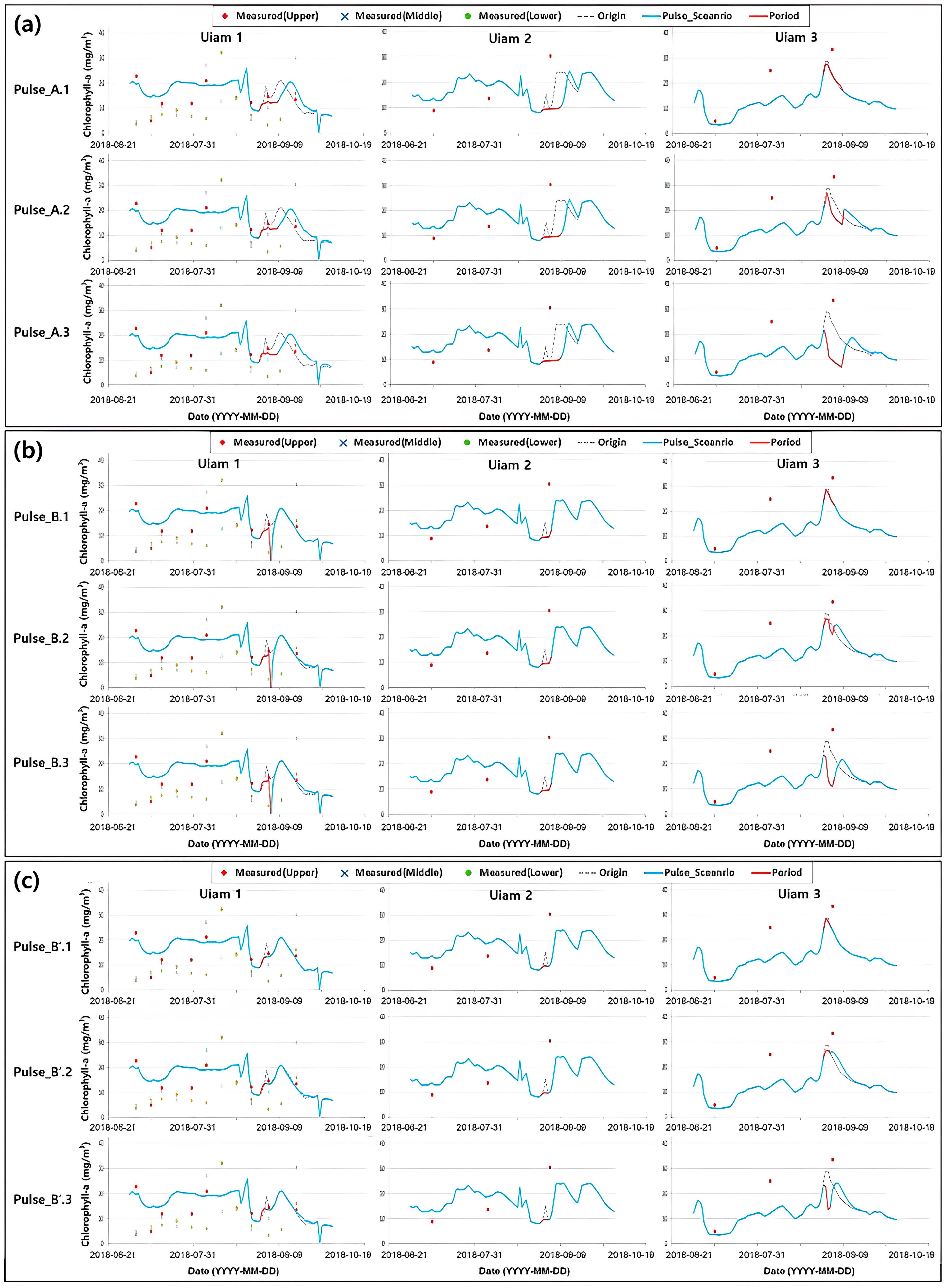
The simulation results for Chl-a at each WQS for each scenario are shown in Figure 10 and summarized in Table 4. Chl-a served as the water quality indicator. Presently, algae warnings are issued based on the number of cyanobacteria. However, due to the challenge of accurately verifying and predicting this using the numerical model EFDC, Chl-a, previously utilized for algae warnings until 2015, was employed instead. Table 5 illustrates a comparison table before and after the revision of the algae warning system threshold.
WQS Uiam 3, located on the left side of Jungdo Island, was mainly affected by the discharge of water from Soyang Dam, a tributary. WQS Uiam 2, located near the right bank, was mainly influenced by Uiam Dam rather than Soyang Dam. WQS Uiam 1, located directly upstream of Uiam Dam, was mainly influenced by Uiam Dam and Chuncheon Dam. For example, in the scenario where a pulse discharge of 250 m3/s was applied for 9 days solely at Chuncheon Dam, the peak Chl-a concentration at Uiam 3 decreased by approximately 6.2%. In contrast, Uiam 1 and Uiam 2 exhibited more substantial reductions, approximately 39% and 61%, respectively. However, after the scenario application period, the Chl-a concentration of both Uiam 1 and Uiam 2 temporarily increased and again approached the warning threshold of 25 mg/m3. There was no significant variation in Uiam 1 and Uiam 2 despite the pulse discharge from Soyang Dam. However, at Uiam 3, the pulse discharge from Soyang Dam decreased by about 27% when it was 30 m3/s (Pulse_A.2) and by about 61% when it was 50 m3/s (Pulse_A.3). Importantly, the Chl-a concentration in the Uiam 3 region did not exceed 20 mg/m3 even after the pulse discharge ceased, and, even with a relatively small pulse discharge from Soyang Dam, optimal water quality improvement effects could be seen. In the case of Uiam 2, Pulse_A scenarios with an additional opening of Uiam Dam of 1 m showed a higher reduction rate than the results of Pulse_B scenarios. At Uiam 2, in the case of Pulse_A.1, Chl-a was reduced by 61%, and, in the case of Pulse_B.1, Chl-a was reduced by about 40%. Additionally, in the case of Pulse_B’.1, which applied the scenario to Chuncheon Dam and Uiam Dam for 3 days, the peak value of Chl-a concentration in Uiam 3 was reduced by about 5%, while the peak value of Uiam 1 and Uiam 2 was reduced by about 30% and 36%, respectively.
In summary, the results show that in the event of an algae warning at Uiam 1 and Uiam 2, a relatively short-duration pulse discharge of approximately 200 m3/s at Chuncheon Dam over about 3 days could effectively mitigate the Chl-a concentration below the warning threshold, although the concentration temporarily increased and then approached the threshold again. In the case of an algae warning at Uiam 3, the optimal water quality improvement effect can be achieved by implementing a pulse discharge of more than 50 m3/s at Soyang Dam, even for a short period of about 3 days.

3.2. Discussion

This study simulated and compared the mitigation of algae in Uiam Reservoir only using a water body management approach such as flushing discharge.
Nine scenarios were meticulously devised to characterize the discharge volume and water level for each dam. In emergency situations, such as harmful algal blooms (HABs) during the summer season, the dams located upstream of Uiam Reservoir can open their water gates to increase the flow rate, creating a flushing flow. This process helps reduce HABs by decreasing the residence time of the water. The scenarios in this study for implementing the flushing flow were based on the practical realities of dam operational management.
The simulation results of these scenarios provided insights into the reduction of algae within Uiam Reservoir, considering the distinctive influence area for each dam. The scenarios demonstrated that the area of influence within Uiam Reservoir varied depending on the dam’s operation. The extent of Chl-a mitigation at each location within the reservoir was also found to be contingent upon dam operation. Uiam 1, positioned directly upstream of Uiam Reservoir, was more profoundly affected by the discharge from Chuncheon Dam compared to Soyang Dam, which had a relatively smaller discharge. Conversely, Uiam 3, situated near the left bank, was predominantly influenced by Soyang Dam. This discrepancy arose from the proximity of Uiam 3 to Soyang Dam, as water released from Chuncheon Dam flowed to the right side due to an island, thereby bypassing Uiam 3. Furthermore, Soyang Reservoir’s considerable depth resulted in water temperature stratification. When the dam was discharged, cooler water from the lower layers was released, and it reached Uiam 3. Based on these findings, it is apparent that when facing an algae emergency within Uiam Reservoir, the optimal reduction of algae can be achieved through targeted dam operations, contingent upon the specific location of the emergency. Observing the pulse_A.3 Uiam 2 results in Figure 10a, it is evident that flushing alone reduces the Chl-a concentration during the dam operation period, but, after finishing the flushing flow, the concentration eventually recovers (increases). However, the results for Uiam 3, which was affected by the low water temperature of the Soyang River, showed that the Chl-a concentration did not return (increase), even after the dam operation was finished.
In summary, Uiam Reservoir is an artificial reservoir formed at the confluence of the main stream of the Bukhan River and its tributary, the Soyang River. Due to its relatively small size compared to the upstream Hwacheon Dam and Soyang River Dam, Uiam Reservoir is significantly influenced by the discharge rates from these upstream dams. Furthermore, the water temperatures of the discharge waters from the dams on the left and right sides of Uiam Reservoir differ by more than 7 °C during the summer season, leading to poor mixing within the reservoir. As shown in Figure 1, the presence of islands in the middle of the reservoir also hinders the mixing of water bodies. Consequently, the mixing and water quality characteristics of Uiam Reservoir are determined by the volume and temperature of the discharge waters from the upstream dams on the left and right sides. Additionally, the geomorphological features of the reservoir, including the presence of islands, make mixing difficult. This study primarily analyzed the hydrological impacts surrounding Uiam Reservoir and the planar topographical influences, rather than focusing on the vertical mixing characteristics of the water body.

4. Conclusions

This study quantitatively analyzed the algae mitigation characteristics of Uiam Reservoir located in Korea, which has the Chuncheon Dam upstream, the Soyanggang Dam in the tributary, and the Uiam Dam downstream, depending on dam operations. The Environmental Fluid Dynamics Code (EFDC) model, which enables three-dimensional hydraulic and water quality simulations, was utilized. A total of nine dam operation scenarios were constructed to analyze algae mitigation characteristics during the summer of 2018, when actual algae blooms reached alert levels. The dam operation scenarios were designed to release a consistent pulse flow from the upstream Chuncheon and Soyang Dams and lower the water level at the downstream Uiam Dam to induce a flushing effect, based on the discharge capacities according to the water levels of each dam. Due to the influence of the different base water temperatures of the Bukhan River and Soyang River and the topographical characteristics, the impact range varied depending on the operation of each dam, and the amount of algae mitigation differed at each point. At the left side region within the reservoir, it was predicted that a pulse discharge of 50 m3/s from the Soyang Dam for three days would reduce the peak value of chlorophyll-a by approximately 50% or more. In contrast, the discharge from the Soyang Dam had little effect on algae mitigation at the right side region of the reservoir. In emergency situations where algae blooms proliferate rapidly, appropriate dam operations in water bodies with large dams upstream and downstream, like Uiam Reservoir, can be effective in reducing algae at specific regions of the reservoir.
Future research should examine the hydraulic and water quality characteristics in the vertical direction in more detail, even though Uiam Reservoir is a shallow reservoir. Additionally, in emergency situations where algae blooms proliferate, as in this study, it will be necessary to evaluate the economic benefits of the improved water quality against the loss of water resources when large amounts are pulse-released from the upstream dams.

Author Contributions

Conceptualization, K.O.B.; methodology, K.O.B. and D.Y.L.; software, D.Y.L.; visualization, D.Y.L.; model calibration and verification, D.Y.L.; formal analysis, D.Y.L.; writing—original draft preparation, D.Y.L.; writing—review and editing, K.O.B.; supervision, K.O.B. All authors have read and agreed to the published version of the manuscript.

Funding

The Basic Science Research Program supported this research through the National Research Foundation (2016R1D1A1B02012110), funded by the Ministry of Education in Korea.

Data Availability Statement

The data presented in this study are available upon request from the corresponding author.

Conflicts of Interest

The authors declare no conflicts of interest.

References

  1. Turner, P.C.; Gammie, A.J.; Hollinrake, K.; Codd, G.A. Pneumonia associated with contact with cyanobacteria. BMJ Br. Med. J. 1990, 300, 1440. [Google Scholar] [CrossRef] [PubMed]
  2. Naderian, D.; Noori, R.; Heggy, E.; Bateni, S.M.; Bhattarai, R.; Nohegar, A.; Sharma, S. A water quality database for global lakes. Resour. Conserv. Recycl. 2024, 202, 107401. [Google Scholar] [CrossRef]
  3. Texeira, M.D.G.L.C.; Costa, M.D.C.N.; Carvalho, V.L.P.D.; Pereira, M.D.S.; Hage, E. Gastroenteritis epidemic in the area of the Itaparica Dam, Bahia, Brazil. Bull. Pan Am. Health Organ. 1993, 27, 244–253. [Google Scholar]
  4. Hawkins, P.R.; Griffiths, D.J. Artificial destratification of a small tropical reservoir: Effects upon the phytoplankton. Hydrobiologia 1993, 254, 169–181. [Google Scholar] [CrossRef]
  5. Carmichael, W.W.; Azevedo, S.M.; An, J.S.; Molica, R.J.; Jochimsen, E.M.; Lau, S.; Rinehart, K.L.; Shaw, G.R.; Eaglesham, G.K. Human fatalities from cyanobacteria: Chemical and biological evidence for cyanotoxins. Environ. Health Perspect. 2001, 109, 663–668. [Google Scholar] [CrossRef] [PubMed]
  6. Falconer, I.R.; Humpage, A.R. Health risk assessment of cyanobacterial (blue-green algal) toxins in drinking water. Int. J. Environ. Res. Public Health 2005, 2, 43–50. [Google Scholar] [CrossRef] [PubMed]
  7. Funari, E.; Testai, E. Human health risk assessment related to cyanotoxins exposure. Crit. Rev. Toxicol. 2008, 38, 97–125. [Google Scholar] [CrossRef] [PubMed]
  8. Zanchett, G.; Oliveira-Filho, E.C. Cyanobacteria and cyanotoxins: From impacts on aquatic ecosystems and human health to anticarcinogenic effects. Toxins 2013, 5, 1896–1917. [Google Scholar] [CrossRef] [PubMed]
  9. Machado, J.; Campos, A.; Vasconcelos, V.; Freitas, M. Effects of microcystin-LR and cylindrospermopsin on plant-soil systems: A review of their relevance for agricultural plant quality and public health. Environ. Res. 2017, 153, 191–204. [Google Scholar] [CrossRef]
  10. Chen, Y.; Xu, J.; Li, Y.; Han, X. Decline of sperm quality and testicular function in male mice during chronic low-dose exposure to microcystin-LR. Reprod. Toxicol. 2011, 31, 551–557. [Google Scholar] [CrossRef]
  11. Häder, D.P.; Kumar, H.D.; Smith, R.C.; Worrest, R. Effects of solar UV radiation on aquatic ecosystems and interactions with climate change. Photochem. Photobiol. Sci. 2007, 6, 267–285. [Google Scholar] [CrossRef] [PubMed]
  12. Joyce, S. The dead zones: Oxygen-starved coastal waters. Environ. Health Perspect. 2000, 108, A120–A125. [Google Scholar] [CrossRef] [PubMed]
  13. Codd, G.A.; Morrison, L.F.; Metcalf, J.S. Cyanobacterial toxins: Risk management for health protection. Toxicol. Appl. Pharmacol. 2005, 203, 264–272. [Google Scholar] [CrossRef] [PubMed]
  14. Lehman, P.W.; Boyer, G.; Hall, C.; Waller, S.; Gehrts, K. Distribution and toxicity of a new colonial Microcystis aeruginosa bloom in the San Francisco Bay Estuary, California. Hydrobiologia 2005, 541, 87–99. [Google Scholar] [CrossRef]
  15. Joh, G.; Lee, J. Cyanobacterial biofilms on sedimentation basins in a water treatment plant in South Korea. J. Appl. Phycol. 2012, 24, 285–293. [Google Scholar] [CrossRef]
  16. Dencheva, K. State of macrophytobenthic communities and ecological status of the Varna Bay, Varna lakes and Burgas Bay. Phytol. Balc. 2010, 16, 43–50. [Google Scholar]
  17. Huh, I.R.; Lee, G.H.; Ham, K.J.; Choi, J.Y.; Jeong, U.H. The study on decline plan of primary production organic matter of Uiam lake basin. J. Korean Soc. Environ. Health 2004, 30, 50–58. [Google Scholar]
  18. Kim, J.M.; Heo, S.N.; Noh, H.R.; Yang, H.J.; Han, M.S. Relationship between limnological characteristics and algal bloom in lake-type and river-type reservoirs, Korea. Korean J. Ecol. Environ. 2003, 36, 124–138. [Google Scholar]
  19. Park, H.G. Causes of algal bloom and reduction measures. Bull. Korea Environ. Preserv. Assoc. 2014, 412, 17–21. [Google Scholar]
  20. World Health Organization (WHO). Management of Cyanobacteria in Drinking-Water Supplies: Information for Regulators and Water Suppliers; WHO/FWC/WSH/15.03; World Health Organization: Geneva, Switzerland, 2015. [Google Scholar]
  21. Huang, Y.; Fu, M.; Chen, G.; Zhang, J.; Xu, P.; Pan, L.; Chen, X. Reducing the water residence time is inadequate to limit the algal proliferation in eutrophic lakes. J. Environ. Manag. 2023, 330, 117177. [Google Scholar] [CrossRef]
  22. Michalak, A.M.; Anderson, E.J.; Beletsky, D.; Boland, S.; Bosch, N.S.; Bridgeman, T.B.; Zagorski, M.A. Record-setting algal bloom in Lake Erie caused by agricultural and meteorological trends consistent with expected future conditions. Proc. Natl. Acad. Sci. USA 2013, 110, 6448–6452. [Google Scholar] [CrossRef] [PubMed]
  23. Chen, Y.; Lin, W.; Zhu, J.; Lu, S. Numerical simulation of an algal bloom in Dianshan Lake. Chin. J. Oceanol. Limnol. 2016, 34, 231–244. [Google Scholar] [CrossRef]
  24. Herman, B.D.; Eberly, J.O.; Jung, C.M.; Medina, V.F. Review and Evaluation of Reservoir Management Strategies for Harmful Algal Blooms; U.S. Army Engineer Research and Development Center: Vicksburg, MS, USA, 2017. [Google Scholar]
  25. Summers, E.J.; Ryder, J.L. A critical review of operational strategies for the management of harmful algal blooms (HABs) in inland reservoirs. J. Environ. Manag. 2023, 330, 117141. [Google Scholar] [CrossRef]
  26. Kim, J.; Kwak, J.; Ahn, J.M.; Kim, H.; Jeon, J.; Kim, K. Oscillation flow dam operation method for algal bloom mitigation. Water 2022, 14, 1315. [Google Scholar] [CrossRef]
  27. Hamrick, J.M. A Three-Dimensional Environmental Fluid Dynamics Computer Code: Theoretical and Computational Aspects; Virginia Institute of Marine Science, Gloucester Point: Virginia, MS, USA, 1992. [Google Scholar]
  28. Jang, J.; Jong, J.; Mun, H.; Kim, K.; Seo, I. Mixing analysis of oil spilled into the river by GPS-equipped drifter experiment and numerical modeling. J. Korean Soc. Water Environ. 2016, 32, 243–252. [Google Scholar] [CrossRef]
  29. Cunanan, A.M.; Salvacion, J.W. Analysis of water temperature of Laguna Lake using EFDC model. Int. J. Sci. Technol. Res. 2014, 3, 68–76. [Google Scholar]
  30. Anderson, M.A. Influence of pumped-storage hydroelectric plant operation on a shallow polymictic lake: Predictions from 3-D hydrodynamic modeling. Lake Reserv. Manag. 2010, 26, 1–13. [Google Scholar] [CrossRef]
  31. Wang, P.; Lai, G.; Li, L. Predicting the hydrological impacts of the Poyang Lake project using an EFDC model. J. Hydrol. Eng. 2015, 20, 05015009. [Google Scholar] [CrossRef]
  32. Lee, D.Y.; Kim, S.E.; Baek, K.O. Modeling of algal fluctuations in the reservoir according to the opening of Yeongju Dam. J. Korea Water Resour. Assoc. 2023, 56, 173–184. [Google Scholar]
  33. Lee, D.Y.; Baek, K.O. Study of the Mitigation of Algae in Lake Uiam according to the Operation of the Chuncheon Dam and the Soyang Dam. KSCE J. Civ. Environ. Eng. Res. 2022, 42, 171–179. [Google Scholar]
  34. Kwon, S.; Seo, I.W.; Kim, D. Effects of hydropeaking by an upstream dam on thermal mixing in a riverine lake. J. Hydrol. 2024, 633, 130992. [Google Scholar] [CrossRef]
  35. Wu, G.; Xu, Z. Prediction of algal blooming using EFDC model: Case study in the Daoxiang Lake. Ecol. Model. 2011, 222, 1245–1252. [Google Scholar] [CrossRef]
  36. Franceschini, S.; Tsai, C.W. Assessment of uncertainty sources in water quality modeling in the Niagara River. Adv. Water Resour. 2010, 33, 493–503. [Google Scholar] [CrossRef]
  37. Li, Y.; Acharya, K.; Yu, Z. Modeling impacts of Yangtze River water transfer on water ages in Lake Taihu, China. Ecol. Eng. 2011, 37, 325–334. [Google Scholar] [CrossRef]
  38. Kim, D.; Kim, Y.; Kim, B. Simulation of eutrophication in a reservoir by CE-QUAL-W2 for the evaluation of the importance of point sources and summer monsoon. Lake Reserv. Manag. 2019, 35, 64–76. [Google Scholar] [CrossRef]
  39. Kim, Y.; Kim, B. Application of a 2-dimensional water quality model (CE-QUAL-W2) to the turbidity interflow in a deep reservoir (Lake Soyang, Korea). Lake Reserv. Manag. 2006, 22, 213–222. [Google Scholar] [CrossRef]
  40. Park, D.K.; Lee, Y. Numerical simulations on the application of a closed-loop lake water heat pump system in the Lake Soyang, Korea. Energies 2020, 13, 762. [Google Scholar] [CrossRef]
  41. Water Resource Management Information System. Available online: http://wamis.go.kr (accessed on 1 June 2024).
  42. Water Environment Information System. Available online: http://water.nier.go (accessed on 1 June 2024).
  43. Tetra Tech, Inc. The Environmental Fluid Dynamics Code Theory and Computation Volume 3: Water Quality Module; Technical report; Tetra Tech Inc.: Virginia, MS, USA, 2007. [Google Scholar]
  44. Moriasi, D.N.; Arnold, J.G.; Van Liew, M.W.; Bingner, R.L.; Harmel, R.D.; Veith, T.L. Model evaluation guidelines for systematic quantification of accuracy in watershed simulation. Trans. ASABE 2007, 50, 885–900. [Google Scholar] [CrossRef]
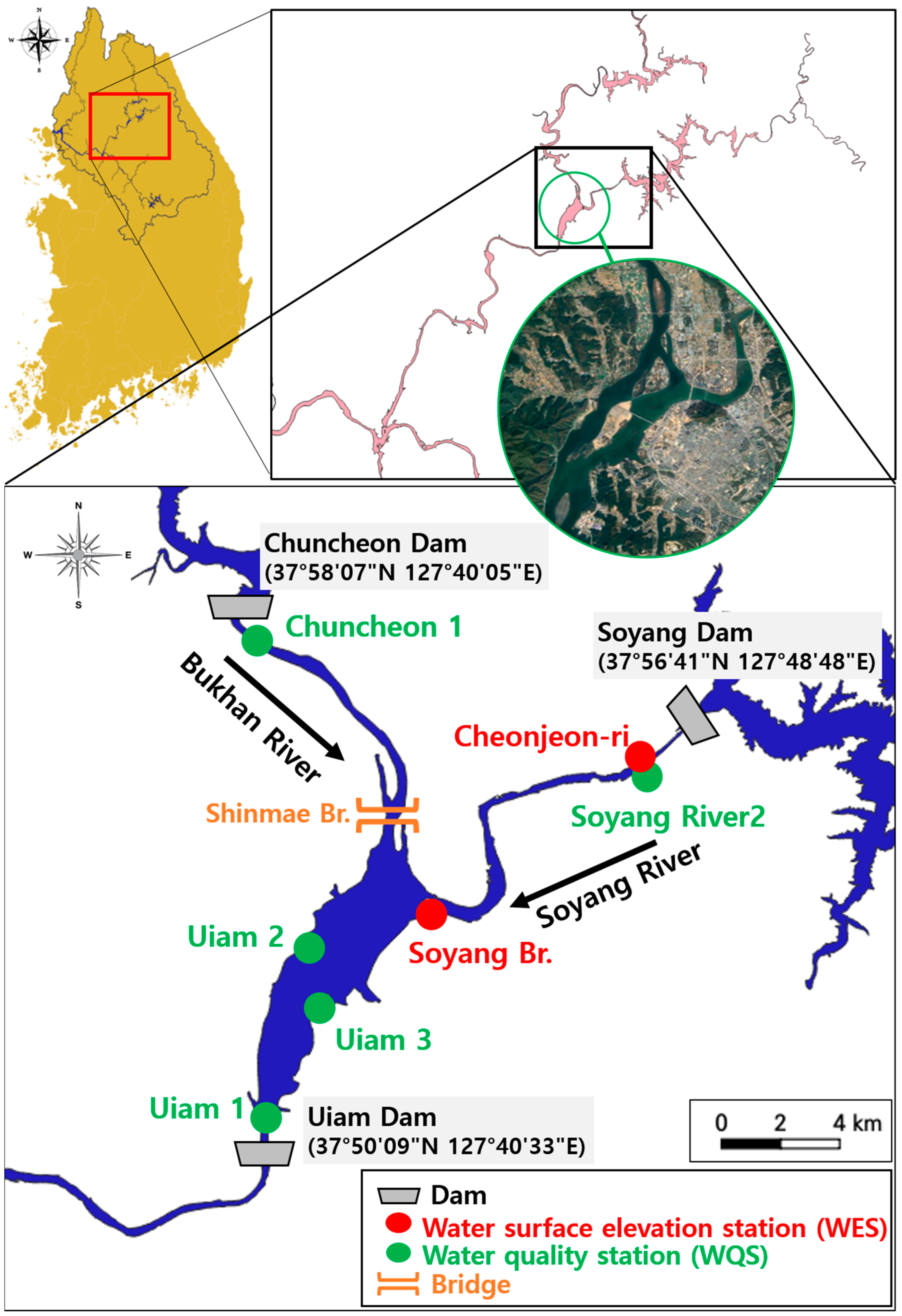
Figure 1. Study area and main observatory points.
Water 16 02120 g001
Figure 2. Characteristics of water temperature in the study area. (a) Time series data of water temperature measured downstream of Chuncheon Dam and Soyang Dam. (b) Water temperature distribution at noon on 30 July 2018 simulated by the EFDC model.
Water 16 02120 g002
Figure 3. Characteristics of velocity in the study area. (a) Simulated flow velocity values at Uiam 2 and Uiam 3. (b) Velocity vector simulated at noon on 30 July 2018 by the EFDC model.
Water 16 02120 g003
Figure 4. Boundary values assigned to the EFDC fluid dynamics model. (a) The inlet boundary representing the flow rates of Chuncheon Dam. (b) The inlet boundary representing the flow rates of Soyang Dam. (c) The outlet boundary representing the water level of Uiam Dam.
Water 16 02120 g004
Figure 5. Simulation results of Chl-a in Uiam Reservoir using 3 layers.
Water 16 02120 g005
Figure 6. Calibration and validation of model for water level. (a) Calibration. (b) Validation.
Water 16 02120 g006
Figure 7. Comparison of measured and calculated data for velocity. (a) Three-dimensional velocity fields measured by ADCP at Shinmae Bridge. (b) Three-dimensional velocity fields measured by ADCP at Uiam 2, (c) Results of the comparison at Shinmae Bridge. (d) Results of the comparison at Uiam 2.
Water 16 02120 g007
Figure 8. Calibration and validation of model for water quality at Uiam 1. (a) Calibration. (b) Validation.
Water 16 02120 g008
Figure 9. Flow rate and velocity changes at Uiam 2 and Uiam 3 according to the operation of the upstream dam applied in Pulse_A.3 scenario. (a) Impact at Uiam 2. (b) Impact at Uiam 3.
Water 16 02120 g009
Figure 10. Simulation results for Ch-a due to dam operation scenarios. (a) Results of pulse_A scenario at each station. (b) Results of pulse_B scenario at each station. (c) Results of pulse_B’ scenario at each station.
Water 16 02120 g010
Table 1. The indices of differences between the observed and calculated data.
Very GoodGoodSatisfactoryUnsatisfactory
PBIAS (%)<2525–4040–70≥70
RMSEThe closer to 0, the higher the reliability.
Table 2. The differences between observed and simulated data for water quality.
DOT-PTOCChl-aTemp.
Uiam 1CalibrationPBIAS17.7047.3912.5552.7011.52
RMSE2.000.010.348.243.34
ValidationPBIAS9.3238.6327.9761.749.15
RMSE1.060.010.6913.222.12
Table 3. Scenarios for dam operation.
PeriodAdditional Opening at
Uiam Dam (m)
Pulse Discharge at Chuncheon Dam (M3/s)Pulse Discharge at Soyang Dam (m3/s)
Pulse_A.131 August~8 September1250-
Pulse_A.231 August~8 September125030
Pulse_A.331 August~8 September125050
Pulse_B.131 August~4 September0.5250-
Pulse_B.231 August~4 September0.525030
Pulse_B.331 August~4 September0.525050
Pulse_B’.131 August~2 September0.5212-
Pulse_ B’.231 August~2 September0.521230
Pulse_ B’.331 August~2 September0.521250
Table 4. Differences in maximum concentration and reduction rate of Chl-a by scenario.
Scenario NameUiam 1Uiam 2Uiam 3
Difference
(mg/m3)
Reduction Rate (%)Difference
(mg/m3)
Reduction Rate (%)Difference
(mg/m3)
Reduction Rate (%)
Pulse_A.1−7.59538.8−15.06761.0−1.6116.2
Pulse_A.2−7.30037.2−15.06761.0−6.35526.8
Pulse_A.3−7.46637.1−15.06761.0−17.43360.6
Pulse_B.1−7.31037.3−5.83638.3−1.8874.5
Pulse_B.2−6.93735.4−5.83438.3−3.48214.2
Pulse_B.3−6.67334.0−5.83438.3−15.25053.0
Pulse_B′.1−5.70130.3−5.54136.3−1.2964.5
Pulse_B′.2−5.27028.0−5.54136.3−2.2418.0
Pulse_B′.3−4.99726.6−5.54136.3−15.26353.1
Table 5. Threshold before and after revision of algal alert.
Before Revision (to 2015)After Revision (from 2016)
Reference itemNumber of cyanobacteria, Chl-aNumber of cyanobacteria
Alert stepCaution500 cells/mL, 15 mg/m3Attention1000 cells/mL
Warning5000 cells/mL, 25 mg/m3Warning10,000 cells/mL
Emergency1,000,000 cells/mL, 100 mg/m3Emergency1,000,000 cells/mL
Disclaimer/Publisher’s Note: The statements, opinions and data contained in all publications are solely those of the individual author(s) and contributor(s) and not of MDPI and/or the editor(s). MDPI and/or the editor(s) disclaim responsibility for any injury to people or property resulting from any ideas, methods, instructions or products referred to in the content.