Abstract
The increase in rainfall intensity caused by climate change, combined with high levels of urban soil sealing and the limited capacity of drainage systems, is significantly increasing flooding risk. Integrated stormwater management is a key factor in dealing with the consequences of climate change by mitigating flood risk based on nature-based solutions. An experimental site was designed to assess the hydrological response of vegetated swales depending on different catchment surfaces, and to evaluate the impact of spatial variability of the hydraulic conductivity (K). A hydrological model was developed on EPA SWMM and calibrated based on measured data in two experimental swales with different active surfaces (N6—50 m2 and N11—100 m2). The model validation was assessed with NSE scores higher than 0.7. The simulations considered various factors, such as the water level in the swales, the actual rainfall, the evapotranspiration, the swale geometry, the catchment area (Sa), and the hydraulic conductivities of the natural silty soil, to assess, for the heaviest rainfall event, the best swale morphological characteristics. The study examined the combined impact of K (8) and Sa (6) on swale storage capacity, designed with a 250 mm depth. The simulations showed that the 250 mm overflow limit was exceeded for N10 (90 m2) when K ≤ 2 × 10⁻⁶ m/s, and for N11 (100 m2) when K ≤ 4 × 10⁻⁶ m/s. These results provide valuable information on the optimal storage capacity based on the swales’ geometrical and physical properties.
1. Introduction
Climate change is a major challenge for the environment [1]. It is disrupting hydrological cycles and impacting rainfall frequency and intensity [2], thereby increasing natural hazards such as flooding, mudslides, and landslides [3].
Stormwater management is a critical issue when it comes to dealing with the destructive effects of heavy rainfall [4]. Today, stormwater management relies mainly on collection and treatment at wastewater treatment plants (WWTPs) [5]. This conventional approach, based on combined or separate sewer systems, leads to high energy consumption at WWTPs [6]. Moreover, sewer networks require regular maintenance and monitoring to prevent network leak contaminations [7,8]. In addition, the significant amount of urban soil sealing amplifies peak runoff, particularly considering the combination of topography and urban growth, combined with the more frequent and intense rainfall, posing a growing risk of urban floods [9]. Combined sewer overflows, storage reservoirs, and retention basins are built to mitigate flooding risk during heavy rainfall events [10,11]. However, these structures need extensive land areas, significant earth-moving operations, and the transportation of substantial amounts of building materials. Hence, a conventional grey infrastructure approach is ineffective to address the climate and environmental challenges [12].
To address these climate change-related challenges, integrated stormwater management relies on a holistic and sustainable approach [12,13]. Several concepts including “Low-Impact Development (LID)”, “Best Management Practices”, “Sponge City”, “Sustainable urban Drainage Systems”, and “Water Sensitive Urban Design” are used to describe integrated stormwater management [14]. LID practises enable multi-objective stormwater management, playing a crucial role in flood risk mitigation and runoff control, decreasing peak volumes at wastewater treatment facilities, incorporating biodiversity and green spaces into urban areas, and enhancing the life quality by mitigating urban heat islands and improving air quality [15,16]. Nature-based solutions, such as infiltration swales, green roofs, and bio-retention/biofiltration basins, serve several functions: stormwater runoff control, groundwater infiltration, sediment and pollution removal, and water transport [17]. LIDs’ hydrological performances, including, for instance, their runoff reduction and leakage rates, have been extensively examined in the literature [18,19,20,21]. Additionally, their effectiveness in runoff pollution and contaminant removal has been investigated by [22,23,24,25]. Furthermore, LIDs are cost-effective and have a limited carbon footprint compared to conventional sewage system approaches [26,27,28], thereby meeting sustainable development goals while considering the geographical limitations in an urban setting [29].
Nevertheless, several challenges limit the broad adoption of LIDs, especially in low hydraulic conductivity areas, such as silty or clayey soils. French guidelines suggest the use of drainage systems in infiltration swales for low hydraulic conductivity soils [30,31]. Consequently, it is crucial to empirically assess the hydrological functioning of swales in these regions to evaluate the impact of the factors affecting the performance of these green infrastructures [32] and enhance design guidelines concerning swales.
The experimental site “ETAGEP” has been designed to address these challenges. The main purpose of the experimental site is to study the hydrological response of vegetated swales by evaluating the influence of hydraulic conductivity and impervious areas. Additionally, it aims to improve LIDs’ hydrological performance by analyzing the influence of fauna and flora on hydraulic conductivity.
This research focuses on the following:
- Evaluating the physical and hydrological properties on the experimental site;
- Assessing the hydrological response of the vegetated swales by calibrating and validating a numerical model;
- Exploring the combined effect of the catchment area and soil hydraulic conductivity on the swales’ hydrological functioning, and identifying the optimal swale geometrical parameters to avoid overflow.
2. Materials and Methods
2.1. Site Description
The ETAGEP experimental site is located on the “Cité Scientifique” campus of the University of Lille, commune of Villeneuve d’Ascq, Métropole Européenne de Lille (MEL), Hauts-de-France region (Figure 1). The research site’s GPS location is 50°36′52.138″ N, 3°8′35.395″ E, and its elevation is 35 m. The climate zone is classified as oceanic “Cfb” [32]. The mean annual precipitation in the MEL region is 740 mm, with an average of 126 rainy days per year, according to the average data from 1991 to 2020 [33].
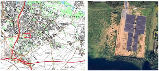
Figure 1.
Location of the ETAGEP experimental site.
The experimental site covers an area of 2500 m2 (Figure 1). It consists of 12 vegetated swales, each 5 m in length and 2 m wide (a total area of 10 m2 for each swale). The storage depth of each swale is 0.25 m, corresponding to a maximum storage capacity of 1.68 m3. To model various urban catchment situations, the swales gather rainwater from two distinct impervious surfaces. The N6 swales (Figure 2) collect rainwater from an impervious area of 50 m2, and the N11 swales (Figure 3) collect rainfall from an impervious area of 100 m2 (as shown in Table 1).
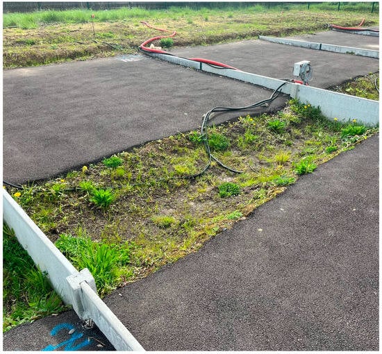
Figure 2.
N6 vegetated swale.
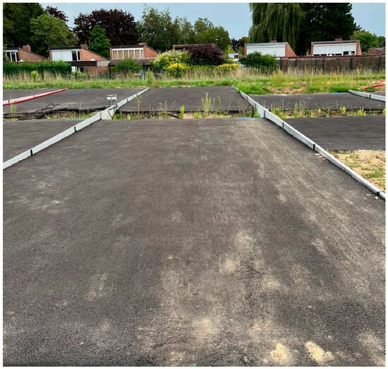
Figure 3.
N11 vegetated swale.

Table 1.
Total catchment area of the N6 and N11 swales.
2.2. Site Monitoring
Each vegetated swale is equipped with a water level pressure sensor (Seba DS22) that provides continuous measurements of the water level in the swale, with a time interval of 10 min and a high level of accuracy (0.05%). The sensors have been precisely calibrated to determine the exact position of the bottom of the ditch (Figure 4).
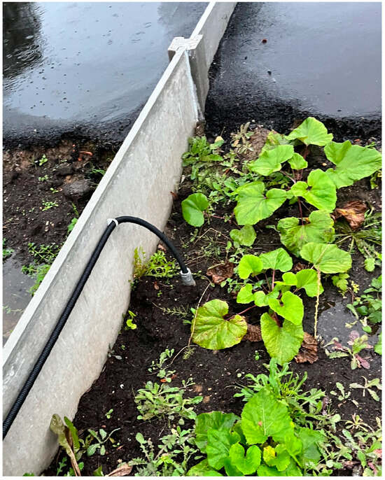
Figure 4.
Water level sensor.
The experimental site is equipped with a meteorological station that includes a bucket rain gauge with a precision of 0.1 mm (Figure 5). The data are recorded at regular intervals of 10 min. Additional meteorological factors that are measured include air temperature, air humidity, wind speed, atmospheric pressure, and net radiation. The meteorological parameters are used to compute the potential evapotranspiration in the swales. The weather data were validated using the meteorological data from the Météo France “Lille-Lesquin” station [34], situated 7 km southwest of the experimental site.
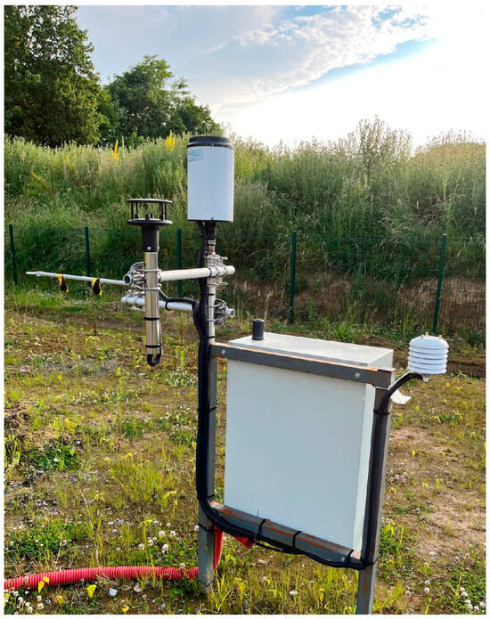
Figure 5.
Site weather station.
The measured data on the site are stored in four dataloggers and sent remotely to the server, ensuring continuous data verification.
2.3. Geology and Soil Characterization
The geological structure of the northern region of France is characterized by the presence of Quaternary clayey and sandy silty layers [35] that overlay Senonian chalky layers from the Cretaceous period [36,37,38]. The chalk aquifer serves as a primary water source for the region’s drinking water supply [39,40]. The water table is located at a depth of 6 m; therefore, the swales are not affected by the water table (Figure 6).
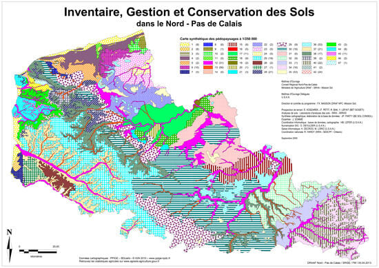
Figure 6.
North of France soil map [35].
Three samples collected from the experimental site were analyzed using a “Mastersizer 3000” laser particle size device to obtain a detailed characterization of soil texture. The analysis revealed a silty soil texture [41] as indicated in Table 2.

Table 2.
Sample particle size distributions.
2.4. Hydraulic Parameter Characterization
The soil hydraulic conductivity characterization was assessed using two approaches: a pedotransfert functions-based method (Rosetta), and an on-site hydraulic conductivity survey (Matsuo).
The initial approach relies on a soil texture-based estimation of the hydraulic conductivity. This approach relies on the USDA’s Rosetta tool [42,43], using pedotransfer functions derived from neural network predictions to estimate the hydraulic conductivity [44]. The hydraulic conductivity estimation varies between 7.05 × 10⁻⁶ m/s and 8.06 × 10⁻⁶ m/s, depending on sample’s soil texture (Table 3). These values are in accordance with the typical silt hydraulic conductivity values, ranging from 10−5 to 10−7 m/s [45].

Table 3.
Estimated hydraulic conductivity.
The second approach is the “Matsuo” percolation test. This infiltration test is recommended in the French technical guides for vegetated swale design [46]. This test is recommended for closely matching the swale morphological characteristics. This model estimates the hydraulic conductivity as follows:
where K (m/s) is the hydraulic conductivity, C (m) is a geometric parameter, L (m) is the ditch length, l (m) is the ditch width, h0 (m) is the initial water level, and h (m) is the measured water level.
A 1.2 m long, 0.7 m wide, and 0.70 m deep ditch was excavated for this test. The trench was filled with water to saturate the soil. Then, the test began with an initial water level of 0.45 m. Based on the calculations, the estimated hydraulic conductivity is 6.55 × 10⁻⁶ m/s (Table 3).
2.5. EPA SWMM Model
EPA SWMM is widely used as a numerical simulation tool for evaluating the performance of LIDs [47,48]. This software offers a LID tool that allows for the configuration of the geometric and hydraulic parameters based on the chosen LID simulation. More specifically, the software includes a “Vegetative Swale” option to simulate swale hydrological performance. This tool has been extensively studied to assess the hydrological response of vegetated swales in the context of urban planning [49,50,51,52]. SWMM calibration and sensitivity analysis models were studied by researchers to enhance the model performances to simulate LID hydrological responses [53,54,55].
The initial model parameters corresponding to the characteristics of the experimental swales are shown in Table 4.

Table 4.
Initial SWMM parameters.
The infiltration model chosen is the Green-Ampt model [56]. This model considers the flow in the soil following a homogeneous and continuous moisture front. It allows for the evaluation of soil infiltration based on the load and suction as follows:
where f(t) is the potential infiltration rate, Ks the saturated hydraulic conductivity, h0 is the pressure head, and hs is the suction head at the wetting front.
The swale vegetation is designed to improve the hydrological response through evapotranspiration. The potential evapotranspiration estimation for green infrastructure have been extensively studied [57,58]. The chosen evapotranspiration model is the Penman Monteith FAO-56 physical model [59]. This model evaluates the potential evapotranspiration by considering the presence of grass with an albedo of 0.23, which is representative of vegetated swales.
This model estimates the potential evapotranspiration as follows:
where ff (m/s) is wind speed, Tmoy (°C) the mean temperature, Rn (MJ/m2/day) is the net radiation, ∆ and γ are parameters based on temperature and atmospheric pressure.
The potential evapotranspiration was calculated using the meteorological data from the site’s weather station. The estimated potential evapotranspiration values have been implemented into the SWMM model.
2.6. Model Performance Index
The NSE indicator (Equation (5)) is widely used to assess hydrological model performance [60,61]. This performance index is used for LID simulation performance analysis [62]. The models’ performances were computed on Python.
The calculation of water level error and drainage time error are evaluated as follows:
3. Results
3.1. Observed Data
The study focused on the 09/20/2023 to 10/22/2023 period. This period was characterized by four heavy rainfall events (Figure 7), resulting in a total cumulative rainfall of 79 mm, with a major event of 31.5 mm. The mean and maximum intensity of the rainfall events are detailed in Table 5.
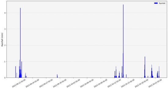
Figure 7.
Rainfall events during the study period.

Table 5.
Rainfall events with their mean and maximum intensities.
During this study period, the potential evapotranspiration, as determined by the Penman Montheith FAO-56 model, did not exceed a daily value of 2 mm (Figure 8).
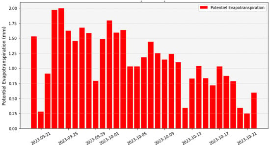
Figure 8.
Estimated potential evapotranspiration.
The hydrological response needs to meet specific geometric and regulatory requirements. These include ensuring that the maximum level does not exceed the overflow limit (250 mm) and that the draining time is lower than 48 or 72 h, depending on the guidelines [30].
The swales stored and managed variable volumes during this period, depending on the impervious areas. The September 21st rainfall event was the heaviest. During this rain event, rainfall reached a cumulative height of 31.5 mm in 14.5 h, resulting, for the N11 swale, in a peak water level of 229 mm (Figure 9), corresponding to a volume of 1.49 m3. For the N6 swale, the maximum water level reached 153.1 mm (Figure 10), corresponding to a volume of 0.81 m3 during this rainy episode.
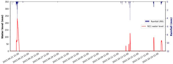
Figure 9.
Measured N11 water levels.
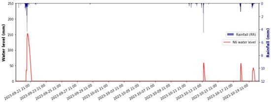
Figure 10.
Measured N6 water levels.
Three other heavy rainfall events occurred during the study period, varying between 9.8 mm and 10.8 mm. Consequently, these events generated significant runoff in the two swales. A peak water level value of 125.8 mm (Figure 10) was reached on October 13 for N11, corresponding to a volume of 0.61 m3. In N6, the peak water level was 58.6 mm (Figure 9), corresponding to a volume of 0.19 m3.
The drainage times during the four rainfall events were short, not exceeding a duration of 9 h and 40 min for the N11 swale and 8 h and 20 min for N6 during the heaviest rain event of 21 September.
3.2. SWMM Simulation
SWMM v.5.2.4 was used to carry out the simulations. Adjustments were made during the calibration process to enhance the performance of the SWMM model. The hydraulic conductivity, swale side slope and vegetation rate (indicated in Table 4) were iteratively modified to achieve a satisfactory model calibration.
The swale water level simulations provided prediction results that closely matched the observed values. The NSE indicator results validate the model’s ability to accurately simulate the hydrological responses of the swales. The NSE scores achieved during the calibration phase were 0.89 for N6 and 0.95 for N11 (Table 6). During this phase, adjustments were made to the hydraulic conductivity. The adjusted hydraulic conductivity values for N6 and N11 were estimated as 11 mm/h and 27 mm/h respectively. The validation phase confirmed the model’s performance, achieving an NSE score of 0.76 for N6 and 0.73 for N11 (Table 6).

Table 6.
Calibration and validation NSE scores.
Figure 11 and Figure 12 show the measured and simulated water levels during the calibration process for the N6 and N11 swales.
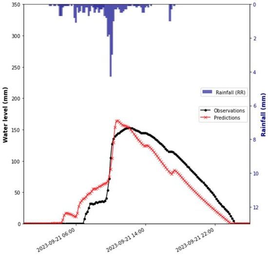
Figure 11.
N6 model calibration.
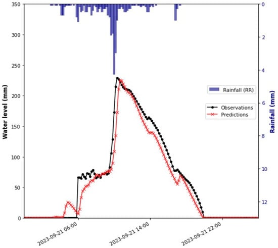
Figure 12.
N11 model calibration.
Figure 13 and Figure 14 show the measured and simulated water levels during the validation process for the N6 and N11 swales.
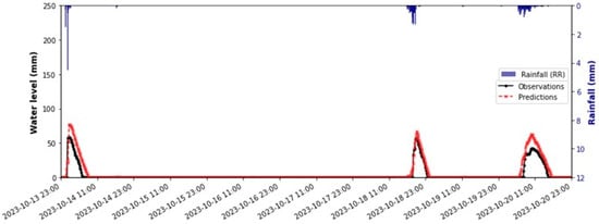
Figure 13.
N6 measured and simulated water levels during the validation process.
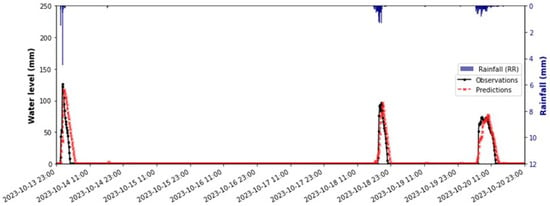
Figure 14.
N11 measured and simulated water levels during the validation process.
The simulation results were compared to the observed water level (Table 7) and draining time (Table 8) values of the experimental swales. For N11, the water level error is satisfactory, with a maximum peak level calculated error of less than 7%. N6’s simulated peak water levels are accurate for the heaviest rainfall event (7.3%). However, the simulated peak water level precision is lower for observed peak levels lower than 60 mm (from 17.3% to 48.6%). The errors can be attributed to slight differences in the morphological characteristics in the swales’ bottom surface.

Table 7.
Water level simulations and errors.

Table 8.
Draining time simulations and errors.
The simulated swales’ draining time is reliable for high rainfall mean intensity events (09/21 and 10/18 with a mean intensity of 2.2 mm/h and 2.1 mm/h respectively). During these rainfall events, the maximum calculated draining time error was 10.0% for N6 and 21.5% for N11 (Table 8). The draining time error was higher for the 10/13 rainfall event, with a calculated error of 46.2% for N6 and 47.3% for N11.
3.3. Combined Effect of Hydraulic Conductivity and Impervious Areas on Swale Hydrological Responses
The hydrological response is influenced by the catchment area and the soil hydraulic conductivity. To assess the impact of these factors, we conducted simulations for the heaviest rainfall event.
Six impervious areas (Table 9) and eight hydraulic conductivities were simulated. During the simulations, we systematically adjusted the hydraulic conductivity within the range of 1 × 10⁻⁶ m/s to 8 × 10⁻⁶ m/s. These values are commonly observed in silty soils. We incremented the conductivity by 1 × 10⁻⁶ m/s in each simulation. Neither the morphological properties of the swales nor the calibration parameters were modified.

Table 9.
Simulated impervious surfaces.
Peak water levels were simulated in SWMM by systematically modifying the hydraulic conductivity and the impervious area. Subsequently, we constructed linear regression curves for every catchment surface scenario (Figure 15).
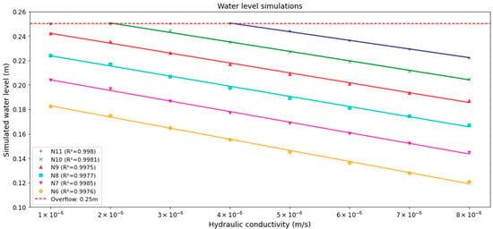
Figure 15.
Peak water level simulations.
The simulations provide insights into the impacting factors of overflow. The swales with smaller impervious surfaces (N6 to N9) did not reach the critical overflow level of 250 mm, despite having the lowest simulated hydraulic conductivity of 1 × 10⁻⁶ m/s. However, for N10 (90 m2) or N11 (100 m2), the critical water level was attained with hydraulic conductivities below 2 × 10⁻⁶ m/s and 4 × 10⁻⁶ m/s, respectively.
To assess the most appropriate geometry for managing this rainfall, we evaluated the peak water level for the N10 and N11 scenarios (Figure 16). This allowed us to identify the optimal swale geometry based on the assessed parameters.
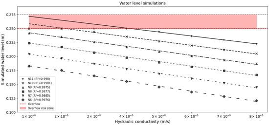
Figure 16.
Swale optimal geometric dimensions for peak water level management.
To prevent any overflow during the simulated rainfall event, for a hydraulic conductivity of 1 × 10⁻⁶ m/s, the N10 storage depth needs to be set to 258 mm, which is 4% higher than the designed depth. N11 requires a storage depth of 272 mm, which is approximately 9% higher than the swale’s actual storage depth.
4. Discussion and Future Work
4.1. Hydrological Response Simulation
Effective sustainable stormwater management involves understanding several factors such as the impervious area, hydraulic conductivity, geometric parameters, and weather conditions. The objective of managing these parameters is to optimize the hydrological functioning of infiltration systems, such as swales. To analyze the performance of the instrumented swales N6 and N11, the SWMM model was adjusted using real rainfall data from four heavy rainfall events. During the calibration, the model’s generated hydraulic conductivity was adjusted iteratively to enhance calibration performance. The calibration confirmed the observed spatial variance in hydraulic conductivity in the two swales. As an illustration, N6 provides an estimated hydraulic conductivity of 11 mm/h (equivalent to 3.06 × 10⁻⁶ m/s) for a measured value on site of 23.6 mm/h (equivalent to 6.55 × 10⁻⁶ m/s). In contrast, the estimated hydraulic conductivity of N11 was 27 mm/h, which closely matched the measured value. Conducting laboratory investigations, such as oedometer testing, is crucial for comprehending the elements that affect the spatial variability of hydraulic conductivity, specifically soil compaction [63,64].
The validation phase reflected the model’s performance, with an NSE value of 0.76 for N6 and 0.73 for N11. To improve the model’s performance, measured data, such as that of the water level, from our experimental swales need to be implemented to provide a more comprehensive understanding of the variability and performance of vegetated swales under different conditions, such as the catchment area and hydraulic conductivity. The model should employ innovative tools for optimal calibration and sensitivity analysis, such as harmony-based and copula-based calibration methods [53,54]. To enhance the model’s performance, the study duration needs to be extended, by integrating longer time series, a wider range of weather conditions, and different rainfall intensities, especially heavy rainfall events higher than 10 mm; heavy rainfall events are relevant for assessing swale overflow, and therefore assess the optimal swale morphological characteristics. Another factor to take into consideration for improving the model is to evaluate the temperature effect on the hydraulic conductivity: a low temperature decreases the hydraulic conductivity, hence impacting the hydrological performance [64].
The simulation of the swales’ response to the heaviest rainfall event (31.5 mm in 14 h) was conducted by considering the combined effects of hydraulic conductivity and impervious surfaces. The simulations explore a range of permeability values, varying from 1 × 10⁻⁶ m/s (equivalent to 3.6 mm/h) to 8 × 10⁻⁶ m/s (equivalent to 28.8 mm/h), and impervious areas, ranging from N6 (50 m2) to N11 (100 m2). These results enable the identification of the finest optimal geometry for sizing the channels, while minimizing the impact on the land. Spatial allocation optimization indexes, suggested by [65], need to be studied based on these results to enhance our understanding of spatial catchment area optimization.
4.2. Hydrological Performance Enhancement
This study does not consider the impact of fauna and flora on the experimental swales. Researchers studied the influence of macrofauna and vegetation on soil water infiltration [64,66]. For this purpose, earthworms and specific vegetations will be implemented in the swales to investigate fauna and flora impacts on enhancing the swales’ hydrological performance.
The hydrological response enhancement can be evaluated by non-invasive techniques specifically designed to assess the influence of fauna and flora [67] developed a Ground Penetrating Radar (GPR)-based model to investigate the influence of vegetation roots and earthworms on soil texture. The established model provides a correlation between the GPR scan signal and earthworm-induced soil hydraulic conductivity enhancement. This GPR model will be tested on the experimental site to investigate the impact of earthworm activity. The findings (the combined effect of macrofauna and flora) will help in overcoming the guideline limitations related to low hydraulic conductivity soils and boarding vegetated swale deployment.
5. Conclusions
This research examines the hydrological performance of vegetated swales. The implementation of these LID solutions is crucial for achieving sustainable stormwater management as they play an essential role in flood risk mitigation, groundwater recharging, and soil unsealing.
A SWMM model was developed to evaluate the hydrological response of two experimental swales by adjusting the model using experimental measurements at the ETAGEP site. The model was initially calibrated based on rainfall, evapotranspiration, hydraulic and geometric parameters, and impervious surfaces. The hydrological model’s performance was assessed during the validation phase, yielding an NSE score of 0.76 for N6 and 0.73 for N11.
The combined effect of hydraulic conductivity and impervious areas was evaluated. The simulations were employed to emphasize the crucial thresholds that result in overflow, as well as to determine the most effective shape for vegetate swale designs to control stormwater through storage, infiltration, and evapotranspiration.
Future work will further explore several aspects to enhance the hydrological model’s performance. Longer time series and heavy rainfall events will be studied. More measured water level data from other experimental swales will be added to improve our model. The effect of physical parameters such as temperature on hydraulic conductivity needs to be examined. The implementation of innovative calibration tools will be incorporated for model optimization. Lastly, there will be large-scale implementation to emphasize integrated stormwater planning strategies for urban flooding risk mitigation, specifically for low hydraulic conductivity areas.
Author Contributions
Conceptualization, K.L. and J.E.K.; methodology, K.L. and J.E.K.; software, K.L.; validation, J.E.K., H.D.N., and A.A.; formal analysis, K.L., J.E.K., H.D.N., and A.A.; investigation, K.L., J.E.K., H.D.N., and A.A.; resources, J.E.K., H.D.N., and A.A.; data curation, K.L.; writing—original draft preparation, K.L.; writing—review and editing, J.E.K.; visualization, K.L., J.E.K., H.D.N., and A.A.; supervision, J.E.K.; project administration, J.E.K.; funding acquisition, J.E.K. All authors have read and agreed to the published version of the manuscript.
Funding
This research was funded by the Agence de l’Eau Artois-Picardie (grant number 2021DRI00435), the Métropole Européenne de Lille (grant number 2021DRI00434) and the Région Hauts-de-France (grant number 2021DRI00140).
Data Availability Statement
The original contributions presented in the study are included in the article; further inquiries can be directed to the corresponding author/s.
Conflicts of Interest
The authors declare no conflicts of interest.
References
- Calvin, K.; Dasgupta, D.; Krinner, G.; Mukherji, A.; Thorne, P.W.; Trisos, C.; Romero, J.; Aldunce, P.; Barrett, K.; Blanco, G.; et al. Climate Change 2023: Synthesis Report. Contribution of Working Groups I, II and III to the Sixth Assessment Report of the Intergovernmental Panel on Climate Change, 1st ed.; Core Writing Team, Lee, H., Romero, J., Eds.; Intergovernmental Panel on Climate Change (IPCC): Geneva, Switzerland, 2023. [Google Scholar]
- Clarke, B.; Otto, F.; Stuart-Smith, R.; Harrington, L. Extreme Weather Impacts of Climate Change: An Attribution Perspective. Environ. Res. Clim. 2022, 1, 012001. [Google Scholar] [CrossRef]
- Debortoli, N.S.; Camarinha, P.I.M.; Marengo, J.A.; Rodrigues, R.R. An Index of Brazil’s Vulnerability to Expected Increases in Natural Flash Flooding and Landslide Disasters in the Context of Climate Change. Nat. Hazards. 2017, 86, 557–582. [Google Scholar] [CrossRef]
- Alim, M.A.; Jahan, S.; Rahman, A.; Rahman, M.A.; Liebman, M.; Garner, B.; Griffith, R.; Griffith, M.; Tao, Z. Experimental Investigation of a Multilayer Detention Roof for Stormwater Management. J. Clean. Prod. 2023, 395, 136413. [Google Scholar] [CrossRef]
- Diogo, A.F.; Barros, L.T.; Santos, J.; Temido, J.S. An Effective and Comprehensive Model for Optimal Rehabilitation of Separate Sanitary Sewer Systems. Sci. Total Environ. 2018, 612, 1042–1057. [Google Scholar] [CrossRef] [PubMed]
- Cardoso, B.J.; Rodrigues, E.; Gaspar, A.R.; Gomes, Á. Energy Performance Factors in Wastewater Treatment Plants: A Review. J. Clean. Prod. 2021, 322, 129107. [Google Scholar] [CrossRef]
- Dhakal, K.P.; Chevalier, L.R. Implementing Low Impact Development in Urban Landscapes: A Policy Perspective. In Proceedings of the World Environmental and Water Resources Congress, Austin, TX, USA, 17–21 May 2015; pp. 322–333. [Google Scholar] [CrossRef]
- Baah, K.; Dubey, B.; Harvey, R.; McBean, E. A Risk-Based Approach to Sanitary Sewer Pipe Asset Management. Sci. Total Environ. 2015, 505, 1011–1017. [Google Scholar] [CrossRef]
- O’Riordan, R.; Davies, J.; Stevens, C.; Quinton, J.N.; Boyko, C. The Ecosystem Services of Urban Soils: A Review. Geoderma 2021, 395, 115076. [Google Scholar] [CrossRef]
- Acheampong, J.N.; Gyamfi, C.; Arthur, E. Impacts of Retention Basins on Downstream Flood Peak Attenuation in the Odaw River Basin, Ghana. J. Hydrol. Reg. Stud. 2023, 47, 101364. [Google Scholar] [CrossRef]
- Yu, D.; Dian, L.; Hai, Y.; Randall, M.T.; Liu, L.; Liu, J.; Zhang, J.; Zheng, X.; Wei, Y. Effect of Rainfall Characteristics on the Sewer Sediment, Hydrograph, and Pollutant Discharge of Combined Sewer Overflow. J. Environ. Manag. 2022, 303, 114268. [Google Scholar] [CrossRef] [PubMed]
- Eckart, K.; McPhee, Z.; Bolisetti, T. Performance and Implementation of Low Impact Development—A Review. Sci. Total Environ. 2017, 607–608, 413–432. [Google Scholar] [CrossRef]
- Bąk, J.; Barjenbruch, M. Benefits, Inconveniences, and Facilities of the Application of Rain Gardens in Urban Spaces from the Perspective of Climate Change—A Review. Water 2022, 14, 1153. [Google Scholar] [CrossRef]
- Zhang, Z.; Hu, W.; Wang, W.; Zhou, J.; Liu, D.; Qi, X.; Zhao, X. The Hydrological Effect and Uncertainty Assessment by Runoff Indicators Based on SWMM for Various LID Facilities. J. Hydrol. 2022, 613, 128418. [Google Scholar] [CrossRef]
- Putri, F.K.; Hidayah, E.; Ma’ruf, M.F. Enhancing Stormwater Management with Low Impact Development (LID): A Review of the Rain Barrel, Bioretention, and Permeable Pavement Applicability in Indonesia. Water Sci. Technol. 2023, 87, 2345–2361. [Google Scholar] [CrossRef]
- Jiang, Y.; Qiu, L.; Gao, T.; Zhang, S. Systematic Application of Sponge City Facilities at Community Scale Based on SWMM. Water 2022, 14, 591. [Google Scholar] [CrossRef]
- Kanso, T. Mesure et Modélisation du Bilan Hydrologique de Dispositifs Rustiques de Gestion à la Source des Eaux de Ruissellement de Chaussées. 313. 2021. Available online: https://pastel.hal.science/tel-03478830 (accessed on 1 July 2024).
- Sui, X.; Van De Ven, F.H.M. The Influence of Low Impact Development (LID) on Basin Runoff in a Half-Urbanized Catchment: A Case Study in San Antonio, Texas. J. Hydrol. 2023, 616, 128793. [Google Scholar] [CrossRef]
- Liu, C.; Xie, T.; Yu, Q.; Niu, C.; Sun, Y.; Xu, Y.; Luo, Q.; Hu, C. Study on the Response Analysis of LID Hydrological Process to Rainfall Pattern Based on Framework for Dynamic Simulation of Urban Floods. J. Environ. Manag. 2024, 351, 119953. [Google Scholar] [CrossRef]
- Guo, Z.; Zhang, X.; Winston, R.; Smith, J.; Yang, Y.; Tao, S.; Liu, H. A Holistic Analysis of Chinese Sponge City Cases by Region: Using PLS-SEM Models to Understand Key Factors Impacting LID Performance. J. Hydrol. 2024, 637, 131405. [Google Scholar] [CrossRef]
- Xie, M.; He, D.; Dong, Z.; Cheng, Y. Storage Scale Assessment of a Low-Impact Development System in a Sponge City. Water 2024, 16, 1427. [Google Scholar] [CrossRef]
- Fardel, A.; Peyneau, P.-E.; Béchet, B.; Lakel, A.; Rodriguez, F. Performance of Two Contrasting Pilot Swale Designs for Treating Zinc, Polycyclic Aromatic Hydrocarbons and Glyphosate from Stormwater Runoff. Sci. Total Environ. 2020, 743, 140503. [Google Scholar] [CrossRef]
- Dutta, A.; Torres, A.S.; Vojinovic, Z. Evaluation of Pollutant Removal Efficiency by Small-Scale Nature-Based Solutions Focusing on Bio-Retention Cells, Vegetative Swale and Porous Pavement. Water 2021, 13, 2361. [Google Scholar] [CrossRef]
- Rech, A.; Pacheco, E.; Caprario, J.; Rech, J.C.; Finotti, A.R. Low-Impact Development (LID) in Coastal Watersheds: Infiltration Swale Pollutant Transfer in Transitional Tropical/Subtropical Climates. Water 2022, 14, 238. [Google Scholar] [CrossRef]
- Alyaseri, I.; Zhou, J.; Morgan, S.M.; Bartlett, A. Initial Impacts of Rain Gardens’ Application on Water Quality and Quantity in Combined Sewer: Field-Scale Experiment. Front. Environ. Sci. Eng. 2017, 11, 19. [Google Scholar] [CrossRef]
- Liu, Z.; Han, Z.; Shi, X.; Liao, X.; Leng, L.; Jia, H. Multi-Objective Optimization Methodology for Green-Gray Coupled Runoff Control Infrastructure Adapting Spatial Heterogeneity of Natural Endowment and Urban Development. Water Res. 2023, 233, 119759. [Google Scholar] [CrossRef] [PubMed]
- Zhu, Y.; Xu, C.; Liu, Z.; Yin, D.; Jia, H.; Guan, Y. Spatial Layout Optimization of Green Infrastructure Based on Life-Cycle Multi-Objective Optimization Algorithm and SWMM Model. Resour. Conserv. Recycl. 2023, 191, 106906. [Google Scholar] [CrossRef]
- Khadka, A.; Kokkonen, T.; Koivusalo, H.; Niemi, T.J.; Leskinen, P.; Körber, J.-H. Stormflow against Streamflow—Can LID-Provided Storage Capacity Ensure Performance Efficiency and Maintenance of Pre-Development Flow Regime? J. Hydrol. 2021, 602, 126768. [Google Scholar] [CrossRef]
- Leng, L.; Xu, C.; Jia, H.; Jia, Q. Incorporating Receiving Waters Responses into the Framework of Spatial Optimization of LID-BMPs in Plain River Network Region. Water Res. 2022, 224, 119036. [Google Scholar] [CrossRef] [PubMed]
- Guide Solutions de Gestion Durable des Eaux Pluviales—Gestion Patrimoniale. Astee. Available online: https://www.enviroxx.com/lpsea.php?utm_medium=CPC&utm_source=Google&utm_campaign=lnk-gads-Envirox&utm_term=gestion%20eau%20pluviale&gad_source=1&gclid=EAIaIQobChMIqMjcgsCthwMVrqpmAh2_EwCcEAAYASAAEgICjfD_BwE (accessed on 10 July 2024).
- Adriengervet Guides Techniques du Grand Lyon. Graie 2012. Available online: https://asso.graie.org/portail/author/adriengervet/page/17/ (accessed on 10 July 2024).
- Pumo, D.; Francipane, A.; Alongi, F.; Noto, L.V. The Potential of Multilayer Green Roofs for Stormwater Management in Urban Area under Semi-Arid Mediterranean Climate Conditions. J. Environ. Manag. 2023, 326, 116643. [Google Scholar] [CrossRef] [PubMed]
- METEO LILLE-LESQUIN Par Météo-France—Prévisions Météo Gratuites à 15 Jours Sur Toutes Les Villes. Available online: https://meteofrance.com/node/572888 (accessed on 25 June 2024).
- Météo-France—Data.gouv.fr. Available online: https://www.data.gouv.fr/fr/organizations/meteo-france/#/datasets (accessed on 10 July 2024).
- Hauts-de-France, D. Carte des Sols Dans le Nord-Pas-de-Calais. Available online: https://draaf.hauts-de-france.agriculture.gouv.fr/carte-des-sols-dans-le-nord-pas-de-calais-a243.html (accessed on 27 June 2024).
- El Khattabi, J.; Carlier, E.; Louche, B. The Effect of Rock Collapse on Coastal Cliff Retreat along the Chalk Cliffs of Northern France. J. Coast. Res. 2018, 341, 136–150. [Google Scholar] [CrossRef]
- Cary, L.; Benabderraziq, H.; Elkhattabi, J.; Gourcy, L.; Parmentier, M.; Picot, J.; Khaska, M.; Laurent, A.; Négrel, P. Tracking Selenium in the Chalk Aquifer of Northern France: Sr Isotope Constraints. Appl. Geochem. 2014, 48, 70–82. [Google Scholar] [CrossRef]
- Darwishe, H.; Khattabi, J.E.; Chaaban, F.; Louche, B.; Masson, E.; Carlier, E. Prediction and Control of Nitrate Concentrations in Groundwater by Implementing a Model Based on GIS and Artificial Neural Networks (ANN). Environ. Earth Sci. 2017, 76, 649. [Google Scholar] [CrossRef]
- Serhal, H.; Bernard, D.; Khattabi, J.E.; Sabine, B.-L.; Shahrour, I. Impact of Fertilizer Application and Urban Wastes on the Quality of Groundwater in the Cambrai Chalk Aquifer, Northern France. Environ. Geol. 2009, 57, 1579–1592. [Google Scholar] [CrossRef]
- Bernard, D.; El Khattabi, J.; Lefevre, E.; Serhal, H.; Bastin-Lacherez, S.; Shahrour, I. Origin of Nickel in Water Solution of the Chalk Aquifer in the North of France and Influence of Geochemical Factors. Environ. Geol. 2008, 53, 1129–1138. [Google Scholar] [CrossRef]
- U.S. Department of Agriculture. Soil Survey Manual; U.S. Department of Agriculture: Washington, DC, USA, 1993. Available online: https://books.google.fr/books?id=BZbGznHmw64C (accessed on 10 July 2024).
- Alvarez-Acosta, C.; Lascano, R.J.; Stroosnijder, L. Test of the Rosetta Pedotransfer Function for Saturated Hydraulic Conductivity. Open J. Soil Sci. 2012, 02, 203–212. [Google Scholar] [CrossRef]
- Rubio, C.M. Applicability of Site-Specific Pedotransfer Functions and Rosetta Model for the Estimation of Dynamic Soil Hydraulic Properties under Different Vegetation Covers. J. Soils Sediments 2008, 8, 137–145. [Google Scholar] [CrossRef]
- Šimůnek, J.; Brunetti, G.; Jacques, D.; van Genuchten, M.T.; Šejna, M. Developments and Applications of the HYDRUS Computer Software Packages since 2016. Vadose Zone J. 2024, 23, e20310. [Google Scholar] [CrossRef]
- Musy, A.; Soutter, M. Physique du sol. In Collection Gérer l’Environnement; Presses Polytechniques et Universitaires Romandes: Lausanne, Switzerland, 1991; ISBN 978-2-88074-211-9. [Google Scholar]
- Recommandations Pour la Commande D’études D’infiltrabilité des Sols|Publications du Cerema. Available online: http://www.cerema.fr/fr/centre-ressources/boutique/recommandations-commande-etudes-infiltrabilite-sols (accessed on 26 June 2024).
- Arjenaki, M.O.; Sanayei, H.R.Z.; Heidarzadeh, H.; Mahabadi, N.A. Modeling and Investigating the Effect of the LID Methods on Collection Network of Urban Runoff Using the SWMM Model (Case Study: Shahrekord City). Model. Earth Syst. Environ. 2021, 7, 1–16. [Google Scholar] [CrossRef]
- Ahmad, S.; Jia, H.; Ashraf, A.; Yin, D.; Chen, Z.; Ahmed, R.; Israr, M. A Novel GIS-SWMM-ABM Approach for Flood Risk Assessment in Data-Scarce Urban Drainage Systems. Water 2024, 16, 1464. [Google Scholar] [CrossRef]
- Neumann, J.; Scheid, C.; Dittmer, U. Potential of Decentral Nature-Based Solutions for Mitigation of Pluvial Floods in Urban Areas—A Simulation Study Based on 1D/2D Coupled Modeling. Water 2024, 16, 811. [Google Scholar] [CrossRef]
- Zhang, Y.; Xu, H.; Liu, H.; Zhou, B. The Application of Low Impact Development Facility Chain on Storm Rainfall Control: A Case Study in Shenzhen, China. Water 2021, 13, 3375. [Google Scholar] [CrossRef]
- Xian, B.C.C.; Kang, C.W.; Wahab, M.A.; Zainol, M.R.R.M.A.; Baharudin, F. Evaluation of Low Impact Development and Best Management Practices on Peak Flow Reduction Using SWMM. IOP Conf. Ser. Earth Environ. Sci. 2021, 646, 012045. [Google Scholar] [CrossRef]
- Yang, F.; Fu, D.; Zevenbergen, C.; Boogaard, F.C.; Singh, R.P. Time-Varying Characteristics of Saturated Hydraulic Conductivity in Grassed Swales Based on the Ensemble Kalman Filter Algorithm—A Case Study of Two Long-Running Swales in Netherlands. J. Environ. Manag. 2024, 351, 119760. [Google Scholar] [CrossRef] [PubMed]
- De Paola, F.; Giugni, M.; Pugliese, F. A Harmony-Based Calibration Tool for Urban Drainage Systems. Proc. Inst. Civ. Eng.-Water Manag. 2018, 171, 30–41. [Google Scholar] [CrossRef]
- Yazdi, J.; Khazaei, P. Copula-Based Performance Assessment of Online and Offline Detention Ponds for Urban Stormwater Management. J. Hydrol. Eng. 2019, 24, 04019025. [Google Scholar] [CrossRef]
- Zhuang, Q.; Li, M.; Lu, Z. Assessing Runoff Control of Low Impact Development in Hong Kong’s Dense Community with Reliable SWMM Setup and Calibration. J. Environ. Manag. 2023, 345, 118599. [Google Scholar] [CrossRef] [PubMed]
- Green, W.H.; Ampt, G.A. Studies on Soil Phyics. J. Agric. Sci. 1911, 4, 1–24. [Google Scholar] [CrossRef]
- Zhang, Y.; Qin, H.; Ye, Y.; Ding, W. The Effect of Low Impact Development Facilities on Evapotranspiration in an Outdoor Space of Urban Buildings. J. Hydrol. 2022, 608, 127647. [Google Scholar] [CrossRef]
- Marasco, D.E.; Culligan, P.J.; McGillis, W.R. Evaluation of Common Evapotranspiration Models Based on Measurements from Two Extensive Green Roofs in New York City. Ecol. Eng. 2015, 84, 451–462. [Google Scholar] [CrossRef]
- Allen, R.G.; Pruitt, W.O.; Wright, J.L.; Howell, T.A.; Ventura, F.; Snyder, R.; Itenfisu, D.; Steduto, P.; Berengena, J.; Yrisarry, J.B.; et al. A Recommendation on Standardized Surface Resistance for Hourly Calculation of Reference ETo by the FAO56 Penman-Monteith Method. Agric. Water Manag. 2006, 81, 1–22. [Google Scholar] [CrossRef]
- Nash, J.E.; Sutcliffe, J.V. River Flow Forecasting through Conceptual Models Part I—A Discussion of Principles. J. Hydrol. 1970, 10, 282–290. [Google Scholar] [CrossRef]
- McCuen, R.H.; Knight, Z.; Cutter, A.G. Evaluation of the Nash–Sutcliffe Efficiency Index. J. Hydrol. Eng. 2006, 11, 597–602. [Google Scholar] [CrossRef]
- Rosa, D.J.; Clausen, J.C.; Dietz, M.E. Calibration and Verification of SWMM for Low Impact Development. J. Am. Water Resour. Assoc. 2015, 51, 746–757. [Google Scholar] [CrossRef]
- Kanso, T.; Tedoldi, D.; Gromaire, M.-C.; Ramier, D.; Saad, M.; Chebbo, G. Horizontal and Vertical Variability of Soil Hydraulic Properties in Roadside Sustainable Drainage Systems (SuDS)—Nature and Implications for Hydrological Performance Evaluation. Water 2018, 10, 987. [Google Scholar] [CrossRef]
- Ebrahimian, A.; Sokolovskaya, N.; Wadzuk, B. Modeling Dynamic Performance of Urban Infiltration Trench Systems: Methodology and a Case Study in Philadelphia. J. Hydrol. 2021, 594, 125938. [Google Scholar] [CrossRef]
- Zhang, K.; Chui, T.F.M. A Comprehensive Review of Spatial Allocation of LID-BMP-GI Practices: Strategies and Optimization Tools. Sci. Total Environ. 2018, 621, 915–929. [Google Scholar] [CrossRef] [PubMed]
- Pham, Q.V.; Nguyen, T.T.; Lam, D.H.; Capowiez, Y.; Nguyen, A.D.; Jouquet, P.; Tran, T.M.; Bottinelli, N. Using Morpho-Anatomical Traits to Predict the Effect of Earthworms on Soil Water Infiltration. Geoderma 2023, 429, 116245. [Google Scholar] [CrossRef]
- Nguyen, H.D.; Khattabi, J.E.L.; Lhamidi, K.; Aljer, A. Evaluation of the Variation of the GPR Frequency Spectra Created by the Activities of Earthworms. J. Appl. Geophys. 2024, 224, 105361. [Google Scholar] [CrossRef]
Disclaimer/Publisher’s Note: The statements, opinions and data contained in all publications are solely those of the individual author(s) and contributor(s) and not of MDPI and/or the editor(s). MDPI and/or the editor(s) disclaim responsibility for any injury to people or property resulting from any ideas, methods, instructions or products referred to in the content. |
© 2024 by the authors. Licensee MDPI, Basel, Switzerland. This article is an open access article distributed under the terms and conditions of the Creative Commons Attribution (CC BY) license (https://creativecommons.org/licenses/by/4.0/).