
Reach-Scale Mapping of Surface Flow Velocities from Thermal Images Acquired by an Uncrewed Aircraft System along the Sacramento River, California, USA


Abstract
1. Introduction
2. Materials and Methods
2.1. Study Area
2.2. Field Measurements
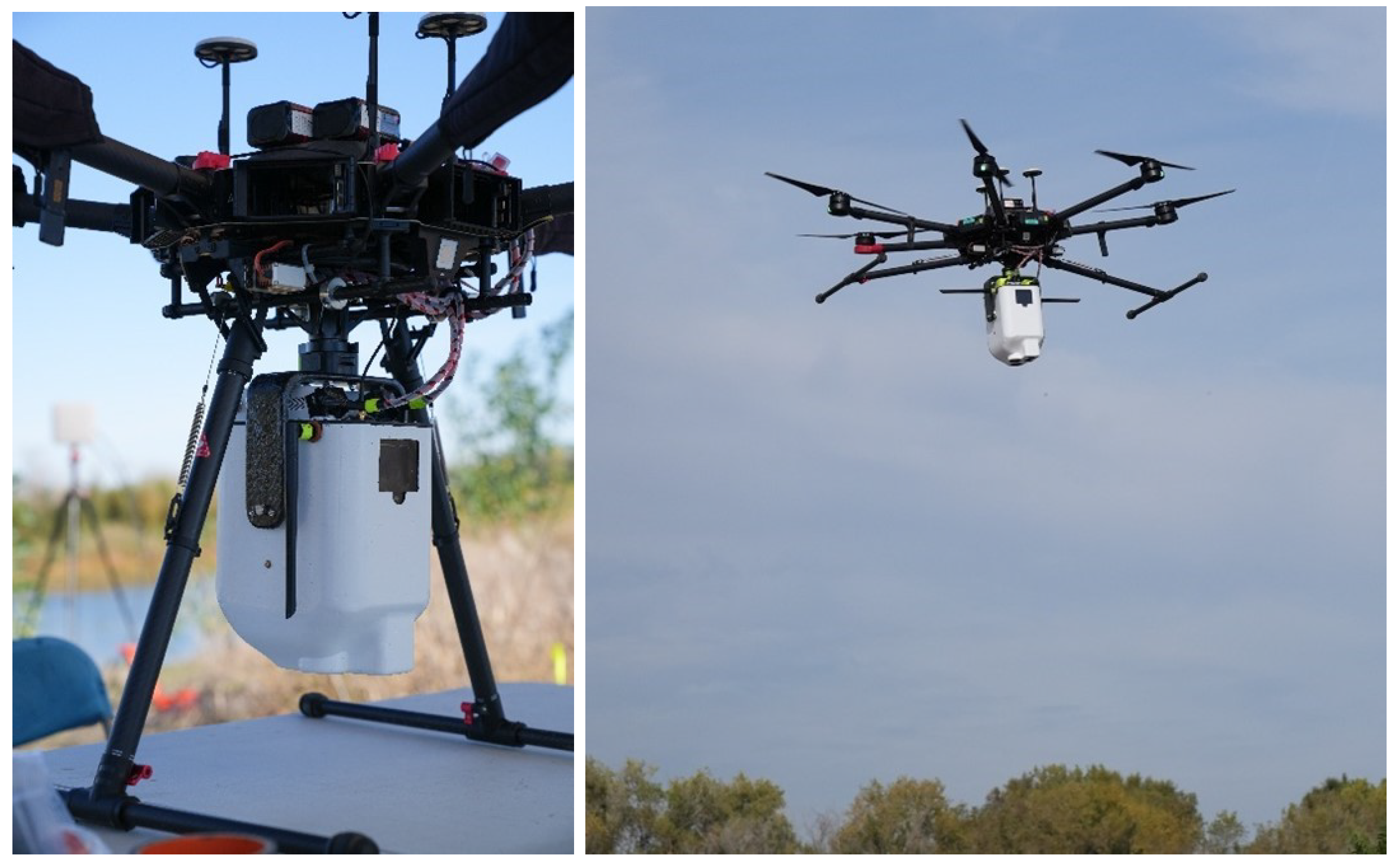
2.3. UAS-Based Image Collection
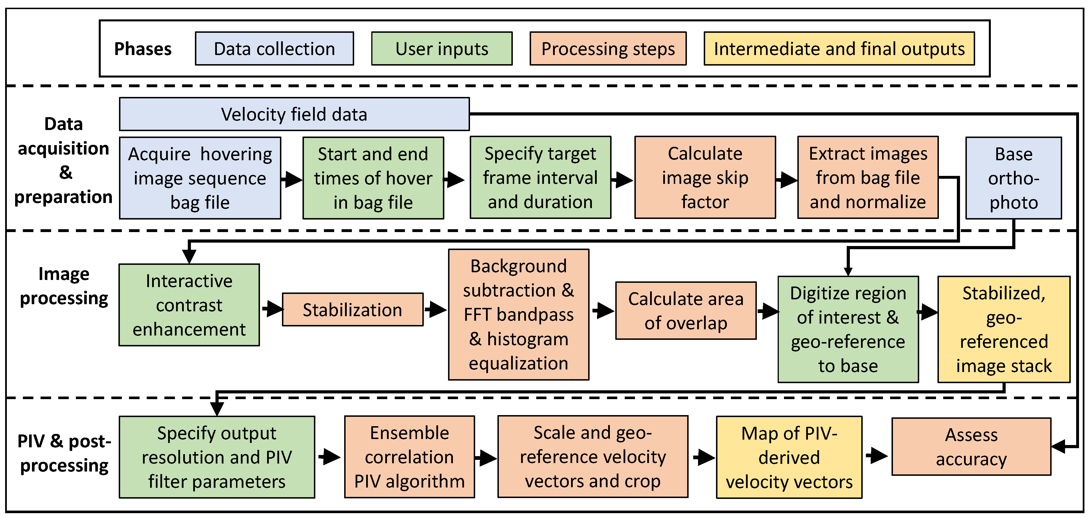
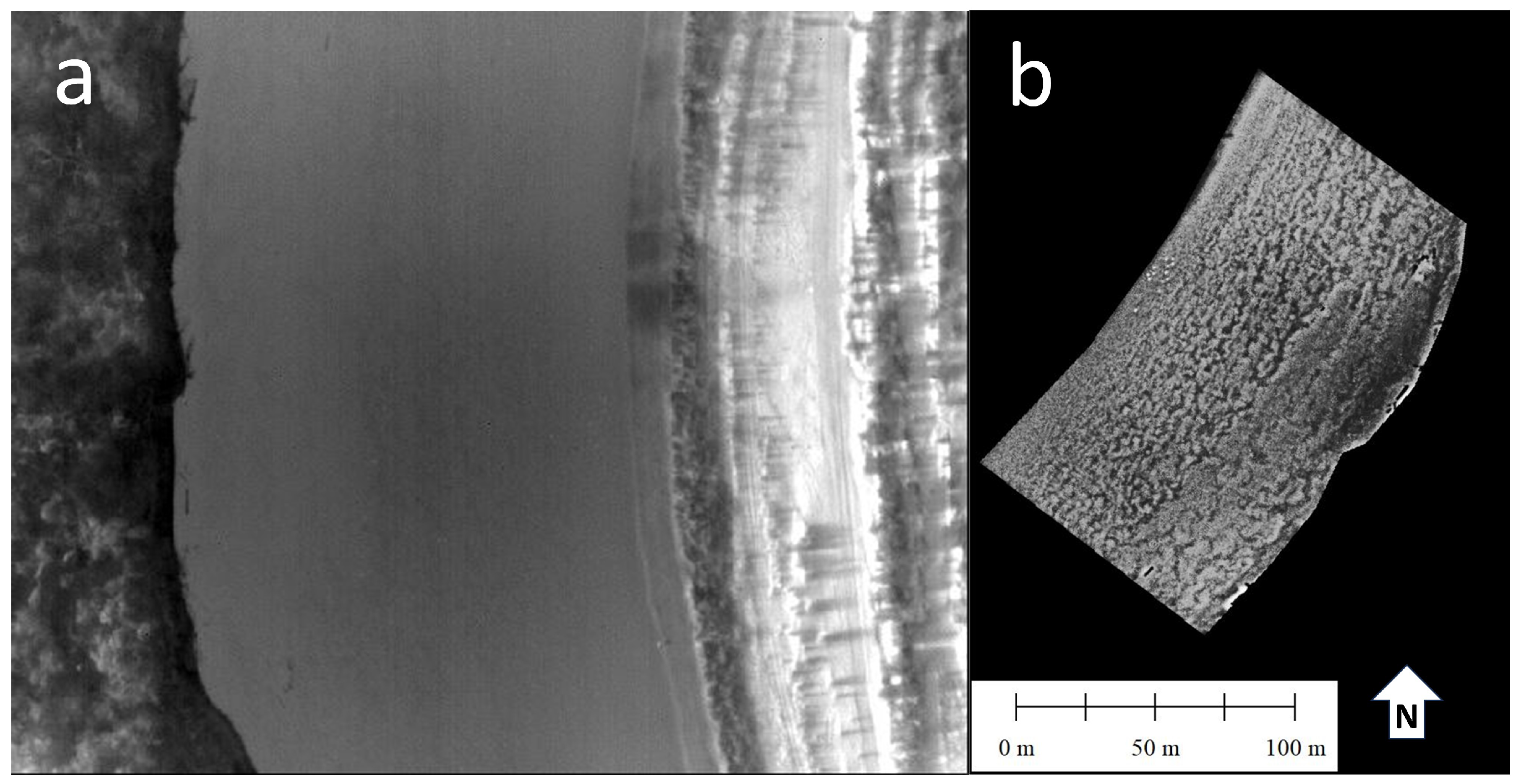
2.4. Thermal Image Processing
2.5. PIV Algorithm
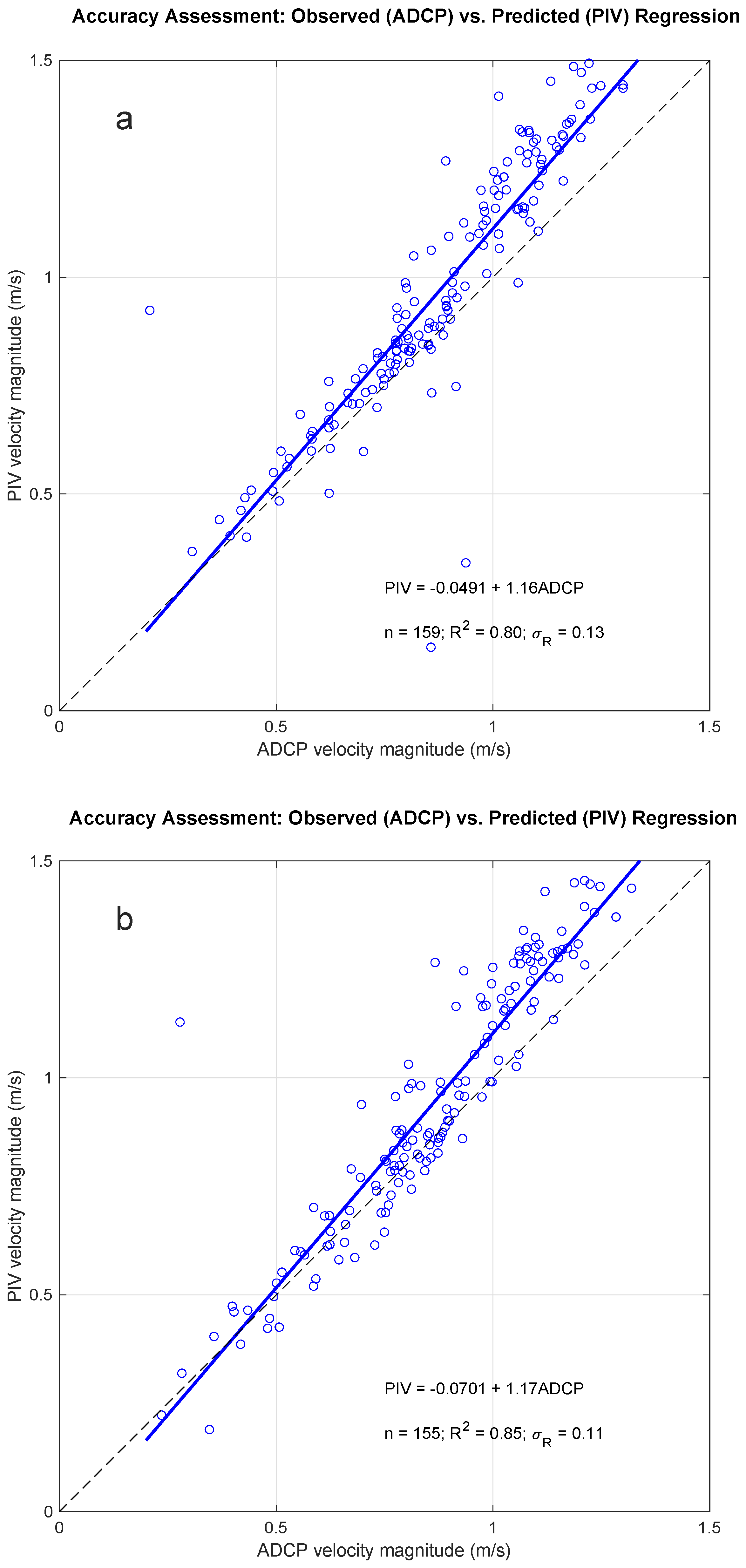
2.6. PIV versus ADCP Accuracy Assessment
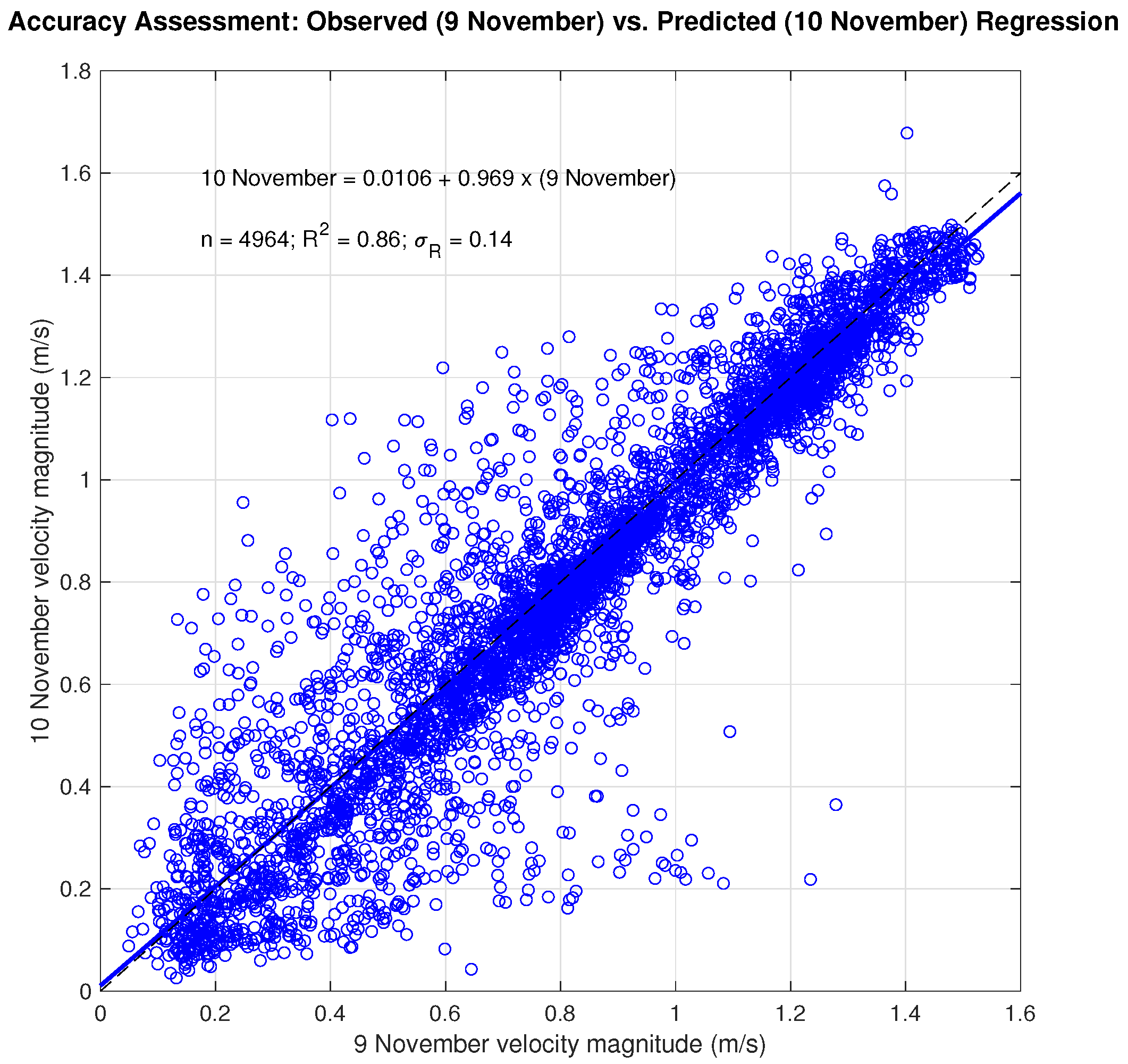
2.7. Day-to-Day PIV Accuracy Assessment
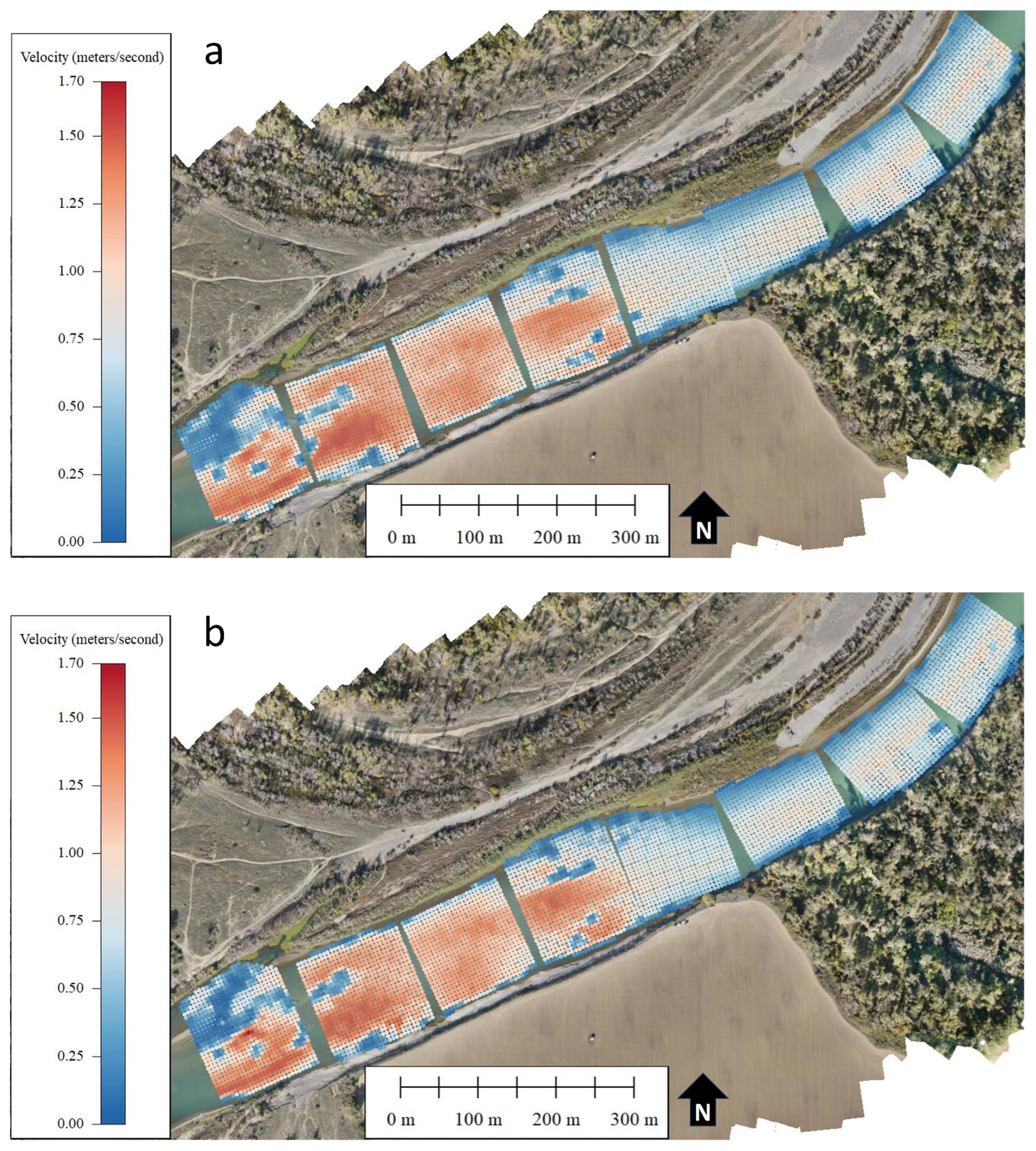
3. Results
4. Discussion
5. Conclusions
Author Contributions
Funding
Data Availability Statement
Acknowledgments
Conflicts of Interest
References
- Conaway, J.S.; Eggleston, J.R.; Legleiter, C.J.; Jones, J.W.; Kinzel, P.J.; Fulton, J.W. Remote Sensing of Streamflow in Alaska Rivers—New Technology to Improve Safety and Expand Coverage of USGS Streamgaging; Fact Sheet 2019-3024; U.S. Geological Survey: Reston, VA, USA, 2019. [CrossRef]
- Durand, M.; Gleason, C.J.; Pavelsky, T.M.; Prata de Moraes Frasson, R.; Turmon, M.; David, C.H.; Altenau, E.H.; Tebaldi, N.; Larnier, K.; Monnier, J.; et al. A Framework for Estimating Global River Discharge From the Surface Water and Ocean Topography Satellite Mission. Water Resour. Res. 2023, 59, e2021WR031614. [Google Scholar] [CrossRef]
- Fulton, J.W.; Mason, C.A.; Eggleston, J.R.; Nicotra, M.J.; Chiu, C.L.; Henneberg, M.F.; Best, H.R.; Cederberg, J.R.; Holnbeck, S.R.; Lotspeich, R.R.; et al. Near-Field Remote Sensing of Surface Velocity and River Discharge Using Radars and the Probability Concept at 10 U.S. Geological Survey Streamgages. Remote Sens. 2020, 12, 1296. [Google Scholar] [CrossRef]
- Tauro, F.; Porfiri, M.; Grimaldi, S. Surface flow measurements from drones. J. Hydrol. 2016, 540, 240–245. [Google Scholar] [CrossRef]
- Peña-Haro, S.; Carrel, M.; Lüthi, B.; Hansen, I.; Lukes, R. Robust Image-Based Streamflow Measurements for Real-Time Continuous Monitoring. Front. Water 2021, 3, 766918. [Google Scholar] [CrossRef]
- Detert, M.; Johnson, E.D.; Weitbrecht, V. Proof-of-concept for low-cost and non-contact synoptic airborne river flow measurements. Int. J. Remote Sens. 2017, 38, 2780–2807. [Google Scholar] [CrossRef]
- Jolley, M.J.; Russell, A.J.; Quinn, P.F.; Perks, M.T. Considerations When Applying Large-Scale PIV and PTV for Determining River Flow Velocity. Front. Water 2021, 3, 709269. [Google Scholar] [CrossRef]
- Fujita, I.; Muste, M.; Kruger, A. Large-scale particle image velocimetry for flow analysis in hydraulic engineering applications. J. Hydraul. Res. 1998, 36, 397–414. [Google Scholar] [CrossRef]
- Muste, M.; Fujita, I.; Hauet, A. Large-scale particle image velocimetry for measurements in riverine environments. Water Resour. Res. 2008, 44, W00D19. [Google Scholar] [CrossRef]
- Tauro, F.; Piscopia, R.; Grimaldi, S. PTV-Stream: A simplified particle tracking velocimetry framework for stream surface flow monitoring. CATENA 2019, 172, 378–386. [Google Scholar] [CrossRef]
- Fujita, I.; Watanabe, H.; Tsubaki, R. Development of a non-intrusive and efficient flow monitoring technique: The space-time image velocimetry (STIV). Int. J. River Basin Manag. 2007, 5, 105–114. [Google Scholar] [CrossRef]
- Legleiter, C.J.; Kinzel, P.J.; Engel, F.L.; Harrison, L.R.; Hewitt, G. A two-dimensional, reach-scale implementation of space-time image velocimetry (STIV) and comparison to particle image velocimetry (PIV). Earth Surf. Process. Landf. 2024. [Google Scholar] [CrossRef]
- Thielicke, W.; Stamhuis, E.J. PIVlab—Towards User-friendly, Affordable and Accurate Digital Particle Image Velocimetry in MATLAB. J. Open Res. Softw. 2014, 2, e30. [Google Scholar] [CrossRef]
- Patalano, A.; García, C.M.; Rodríguez, A. Rectification of Image Velocity Results (RIVeR). Comput. Geosci. 2017, 109, 323–330. [Google Scholar] [CrossRef]
- Eltner, A.; Sardemann, H.; Grundmann, J. Technical Note: Flow velocity and discharge measurement in rivers using terrestrial and unmanned-aerial-vehicle imagery. Hydrol. Earth Syst. Sci. 2020, 24, 1429–1445. [Google Scholar] [CrossRef]
- Legleiter, C.J.; Kinzel, P.J. The Toolbox for River Velocimetry using Images from Aircraft (TRiVIA). River Res. Appl. 2023, 39, 1457–1468. [Google Scholar] [CrossRef]
- Ljubičić, R.; Dal Sasso, S.F.; Zindović, B. SSIMS-Flow: Image velocimetry workbench for open-channel flow rate estimation. Environ. Model. Softw. 2024, 173, 105938. [Google Scholar] [CrossRef]
- Detert, M.; Cao, L.; Albayrak, I. Airborne Image Velocimetry Measurements at the Hydropower Plant Schiffmühle on Limmat River, Switzerland. In Proceedings of the 2nd International Symposium and Exhibition on Hydro-Environment Sensors and Software, HydroSenSoft 2019, Madrid, Spain, 26 February–1 March 2019; pp. 211–217. [Google Scholar]
- Pizarro, A.; Dal Sasso, S.F.; Perks, M.T.; Manfreda, S. Identifying the optimal spatial distribution of tracers for optical sensing of stream surface flow. Hydrol. Earth Syst. Sci. 2020, 24, 5173–5185. [Google Scholar] [CrossRef]
- Strelnikova, D.; Paulus, G.; Käfer, S.; Anders, K.H.; Mayr, P.; Mader, H.; Scherling, U.; Schneeberger, R. Drone-Based Optical Measurements of Heterogeneous Surface Velocity Fields around Fish Passages at Hydropower Dams. Remote Sens. 2020, 12, 384. [Google Scholar] [CrossRef]
- Biggs, H.J.; Smith, B.; Detert, M.; Sutton, H. Surface image velocimetry: Aerial tracer particle distribution system and techniques for reducing environmental noise with coloured tracer particles. River Res. Appl. 2022, 38, 1192–1198. [Google Scholar] [CrossRef]
- Duan, J.G.; Engel, F.L.; Cadogan, A. Discharge Estimation Using Video Recordings from Small Unoccupied Aircraft Systems. J. Hydraul. Eng. 2023, 149, 04023048. [Google Scholar] [CrossRef]
- Chickadel, C.C.; Talke, S.A.; Horner-Devine, A.R.; Jessup, A.T. Infrared-Based Measurements of Velocity, Turbulent Kinetic Energy, and Dissipation at the Water Surface in a Tidal River. IEEE Geosci. Remote Sens. Lett. 2011, 8, 849–853. [Google Scholar] [CrossRef]
- Puleo, J.A.; McKenna, T.E.; Holland, K.T.; Calantoni, J. Quantifying riverine surface currents from time sequences of thermal infrared imagery. Water Resour. Res. 2012, 48, W01527. [Google Scholar] [CrossRef]
- Fujita, I.; Kosaka, Y.; Honda, M.; Yorozuya, A.; Motonaga, Y. Day and Night Measurements of Snow Melt Floods by STIV with a Far Infrared Camera. In Proceedings of the 35th IAHR World Congress, Chengdu, China, 8–13 September 2013; p. 8. [Google Scholar]
- Lin, D.; Grundmann, J.; Eltner, A. Evaluating Image Tracking Approaches for Surface Velocimetry with Thermal Tracers. Water Resour. Res. 2019, 55, 3122–3136. [Google Scholar] [CrossRef]
- Legleiter, C.J.; Kinzel, P.J.; Nelson, J.M. Remote measurement of river discharge using thermal particle image velocimetry (PIV) and various sources of bathymetric information. J. Hydrol. 2017, 554, 490–506. [Google Scholar] [CrossRef]
- Schweitzer, S.A.; Cowen, E.A. Instantaneous River-Wide Water Surface Velocity Field Measurements at Centimeter Scales Using Infrared Quantitative Image Velocimetry. Water Resour. Res. 2021, 57, e2020WR029279. [Google Scholar] [CrossRef]
- Dugan, J.P.; Anderson, S.P.; Piotrowski, C.C.; Zuckerman, S.B. Airborne Infrared Remote Sensing of Riverine Currents. IEEE Trans. Geosci. Remote Sens. 2014, 52, 3895–3907. [Google Scholar] [CrossRef]
- Legleiter, C.J.; Kinzel, P.J.; Laker, M.; Conaway, J.S. Moving Aircraft River Velocimetry (MARV): Framework and Proof-of-Concept on the Tanana River. Water Resour. Res. 2023, 59, e2022WR033822. [Google Scholar] [CrossRef]
- Eltner, A.; Bertalan, L.; Grundmann, J.; Perks, M.T.; Lotsari, E. Hydro-morphological mapping of river reaches using videos captured with UAS. Earth Surf. Process. Landf. 2021, 46, 2773–2787. [Google Scholar] [CrossRef]
- MacDonell, C.J.; Williams, R.D.; Maniatis, G.; Roberts, K.; Naylor, M. Consumer-grade UAV solid-state LiDAR accurately quantifies topography in a vegetated fluvial environment. Earth Surf. Process. Landf. 2023, 48, 2211–2229. [Google Scholar] [CrossRef]
- Kinzel, P.J.; Legleiter, C.J. sUAS-Based Remote Sensing of River Discharge Using Thermal Particle Image Velocimetry and Bathymetric Lidar. Remote Sens. 2019, 11, 2317. [Google Scholar] [CrossRef]
- Eltner, A.; Mader, D.; Szopos, N.; Nagy, B.; Grundmann, J.; Bertalan, L. Using Thermal and Rgb Uav Imagery to Measure Surface Flow Velocities of Rivers. Int. Arch. Photogramm. Remote Sens. Spat. Inf. Sci. 2021, XLIII-B2-2021, 717–722. [Google Scholar] [CrossRef]
- U.S. Geological Survey. USGS Water Data for the Nation: U.S. Geological Survey National Water Information System Database. 2024. Available online: https://waterdata.usgs.gov/nwis (accessed on 9 April 2024). [CrossRef]
- Legleiter, C.J.; Harrison, L.R. Evaluating the potential for efficient, UAS-based reach-scale mapping of river channel bathymetry from multispectral images. Front. Remote Sens. 2024, 5, 1305991. [Google Scholar] [CrossRef]
- Legleiter, C.J.; Kinzel, P.J. A framework to facilitate development and testing of image-based river velocimetry algorithms. Earth Surf. Process. Landf. 2024, 49, 1361–1382. [Google Scholar] [CrossRef]
- Xylem. SonTek M9 Brochure. 2024. Available online: https://www.xylem.com/siteassets/brand/sontek/resources/brochure/sontek-m9-brochure.pdf (accessed on 5 May 2024).
- Xylem. SonTek RiverSurveyor Live Software. 2024. Available online: https://www.xylem.com/en-us/products–services/software/riversurveyor-live-rsl/ (accessed on 5 May 2024).
- Parsons, D.R.; Jackson, P.R.; Czuba, J.A.; Engel, F.L.; Rhoads, B.L.; Oberg, K.A.; Best, J.L.; Mueller, D.S.; Johnson, K.K.; Riley, J.D. Velocity Mapping Toolbox (VMT): A processing and visualization suite for moving-vessel ADCP measurements. Earth Surf. Process. Landf. 2013, 38, 1244–1260. [Google Scholar] [CrossRef]
- Kinzel, P.; Legleiter, C.; Gazoorian, C. Thermal Imagery Acquired from an Uncrewed Aerial System (UAS) and Hydroacoustic Measurements of Flow Velocity Collected along the Sacramento River, California, November, 2023; U.S. Geological Survey Data Release; U.S. Geological Survey: Reston, VA, USA, 2024. [CrossRef]
- Quigley, M.; Conley, K.; Gerkey, B.P.; Faust, J.; Foote, T.; Leibs, J.; Wheeler, R.; Ng, A.Y. ROS: An open-source Robot Operating System. In Proceedings of the ICRA Workshop on Open Source Software, Kobe, Japan, 12–17 May 2009; Volume 3, p. 5. [Google Scholar]
- Legleiter, C.J.; Dille, M. A Robot Operating System (ROS) package for mapping flow fields in rivers via Particle Image Velocimetry (PIV). SoftwareX 2024, 26, 101711. [Google Scholar] [CrossRef]
- DJI. Matrice 600 Pro. 2024. Available online: https://www.dji.com/support/product/matrice600-pro (accessed on 5 May 2024).
- Infrared Cameras Inc. Mirage 640 P Series. 2024. Available online: https://infraredcameras.com/products/mirage-640-p-series (accessed on 5 May 2024).
- Drone Amplified. Ignis Application, Government Edition, Version 2.20.40. 2024. Available online: https://droneamplified.com/downloads/android/apks_for_dji/government_edition/latest/ (accessed on 10 June 2024).
- Legleiter, C.; Kinzel, P.J. Inferring Surface Flow Velocities in Sediment-Laden Alaskan Rivers from Optical Image Sequences Acquired from a Helicopter. Remote Sens. 2020, 12, 1282. [Google Scholar] [CrossRef]
- Foxglove Studio. 2024. Available online: https://foxglove.dev/download (accessed on 5 May 2024).
- The MathWorks Inc. MATLAB Version: 24.1.0.2603908 (R2024a). 2024. Available online: https://www.mathworks.com (accessed on 5 May 2024).
- Willman, C.; Scott, B.; Stone, R.; Richardson, D. Quantitative metrics for comparison of in-cylinder velocity fields using particle image velocimetry. Exp. Fluids 2020, 61, 62. [Google Scholar] [CrossRef]
- Smart, G.M.; Biggs, H.J. Remote gauging of open channel flow: Estimation of depth averaged velocity from surface velocity and turbulence. In Proceedings of the River Flow 2020, Delft, The Netherlands, 7–10 July 2020; pp. 1–10. [Google Scholar]
- Biggs, H.; Smart, G.; Doyle, M.; Eickelberg, N.; Aberle, J.; Randall, M.; Detert, M. Surface Velocity to Depth-Averaged Velocity—A Review of Methods to Estimate Alpha and Remaining Challenges. Water 2023, 15, 3711. [Google Scholar] [CrossRef]
- Rantz, S.; Others, A. Measurement and Computation of Streamflow: Volume 1. Measurement of Stage and Discharge. U.S. Geol. Surv. Water Supply Pap. 1982, 2175, 284. [Google Scholar] [CrossRef]
- Zuiderveld, K. Contrast Limited Adaptive Histograph Equalization. In Graphic Gems IV; Academic Press Professional: Cambridge, MA, USA, 1994; pp. 474–485. [Google Scholar]
- Steel, E.A.; Beechie, T.J.; Torgersen, C.E.; Fullerton, A.H. Envisioning, Quantifying, and Managing Thermal Regimes on River Networks. BioScience 2017, 67, 506–522. [Google Scholar] [CrossRef]
- Harvey, M.C.; Hare, D.K.; Hackman, A.; Davenport, G.; Haynes, A.B.; Helton, A.; Lane, J.W.; Briggs, M.A. Evaluation of Stream and Wetland Restoration Using UAS-Based Thermal Infrared Mapping. Water 2019, 11, 1568. [Google Scholar] [CrossRef]


| Model | ICI Mirage 640 P-Series [45] |
| Lens | 11.2 mm |
| Detector | Cooled Indium Antimonide |
| Pixel dimensions on focal array | 15 μm |
| Number of pixels | 640 × 512 |
| Wavelength range | 3–5 μm |
| Noise-equivalent temperature difference | <0.012 °C at 30 °C |
| Bits per pixel | 14 |
| Camera dimensions | 111 × 96 × 131 mm |
| Camera weight | <765 g (without lens) |
| Power | 12 V |
| XS | Obs. vs Pred. | Norm. | Norm. | Slope | Intercept | n |
|---|---|---|---|---|---|---|
| RMSE | Bias | |||||
| 9 November 2023 | ||||||
| 900 | 0.94 | 0.12 | 0.10 | 1.16 | −0.04 | 14 |
| 1050 | 0.95 | 0.05 | 0.02 | 0.96 | 0.04 | 19 |
| 1200 | 0.87 | 0.15 | 0.11 | 1.03 | 0.05 | 17 |
| 1350 | 0.96 | 0.06 | 0.04 | 1.05 | −0.01 | 22 |
| 1500 | 0.86 | 0.14 | 0.11 | 1.28 | −0.16 | 25 |
| 1650 | 0.59 | 0.20 | 0.18 | 1.37 | −0.20 | 23 |
| 1800 | 0.68 | 0.19 | 0.16 | 1.27 | −0.11 | 22 |
| 1950 | 0.68 | 0.23 | 0.01 | 2.25 | −1.34 | 17 |
| 10 November 2023 | ||||||
| 900 | 0.75 | 0.14 | 0.04 | 1.02 | 0.01 | 16 |
| 1050 | 0.97 | 0.04 | 0.00 | 1.00 | 0.00 | 18 |
| 1200 | 0.94 | 0.11 | 0.04 | 1.14 | −0.06 | 20 |
| 1350 | 0.72 | 0.09 | −0.02 | 0.84 | 0.10 | 20 |
| 1500 | 0.77 | 0.17 | 0.14 | 1.18 | −0.04 | 22 |
| 1650 | 0.83 | 0.18 | 0.18 | 1.43 | −0.25 | 23 |
| 1800 | 0.60 | 0.17 | 0.14 | 1.04 | 0.11 | 21 |
| 1950 | 0.86 | 0.09 | 0.06 | 1.36 | −0.33 | 15 |
Disclaimer/Publisher’s Note: The statements, opinions and data contained in all publications are solely those of the individual author(s) and contributor(s) and not of MDPI and/or the editor(s). MDPI and/or the editor(s) disclaim responsibility for any injury to people or property resulting from any ideas, methods, instructions or products referred to in the content. |
© 2024 by the authors. Licensee MDPI, Basel, Switzerland. This article is an open access article distributed under the terms and conditions of the Creative Commons Attribution (CC BY) license (https://creativecommons.org/licenses/by/4.0/).
Share and Cite
Kinzel, P.J.; Legleiter, C.J.; Gazoorian, C.L. Reach-Scale Mapping of Surface Flow Velocities from Thermal Images Acquired by an Uncrewed Aircraft System along the Sacramento River, California, USA. Water 2024, 16, 1870. https://doi.org/10.3390/w16131870
Kinzel PJ, Legleiter CJ, Gazoorian CL. Reach-Scale Mapping of Surface Flow Velocities from Thermal Images Acquired by an Uncrewed Aircraft System along the Sacramento River, California, USA. Water. 2024; 16(13):1870. https://doi.org/10.3390/w16131870
Chicago/Turabian StyleKinzel, Paul J., Carl J. Legleiter, and Christopher L. Gazoorian. 2024. "Reach-Scale Mapping of Surface Flow Velocities from Thermal Images Acquired by an Uncrewed Aircraft System along the Sacramento River, California, USA" Water 16, no. 13: 1870. https://doi.org/10.3390/w16131870
APA StyleKinzel, P. J., Legleiter, C. J., & Gazoorian, C. L. (2024). Reach-Scale Mapping of Surface Flow Velocities from Thermal Images Acquired by an Uncrewed Aircraft System along the Sacramento River, California, USA. Water, 16(13), 1870. https://doi.org/10.3390/w16131870