Article

Groundwater Recharge Assessment in Central Benin: The Case of the Collines Region (West Africa)

by
Kodjo Apelete Raoul Kpegli
1,*,
Firmin Adandedji
1,
Cintia Ahouandogbo
2,
Metogbe Belfrid Djihouessi
3,
Jean Hounkpe
1,
Yèkambèssoun N’Tcha M’Po
1,
Aymar Yaovi Bossa
2,
Abdoukarim Alassane
1,
Luc Olivier Sintondji
2,
Daouda Mama
1 and
Moussa Boukari
1
1
Laboratoire d’Hydrologie Appliquée, Institut National de l’Eau, Université d’Abomey-Calavi, Cotonou 01 BP 4521, Benin
2
Laboratoire d’Hydraulique et de Maîtrise de l’Eau, Université d’Abomey-Calavi, Cotonou 01 BP 4521, Benin
3
Laboratoire des Sciences et Techniques de l’Eau, Université d’Abomey-Calavi, Cotonou 01 BP 4521, Benin
*
Author to whom correspondence should be addressed.
Water 2024, 16(10), 1330; https://doi.org/10.3390/w16101330
Submission received: 19 March 2024 / Revised: 16 April 2024 / Accepted: 18 April 2024 / Published: 7 May 2024
(This article belongs to the Special Issue Groundwater Monitoring, Assessment and Modelling)

Abstract

:
The objective of this study was to assess groundwater recharge in the hard-rock central region of Benin so as to compare it with the water needs of the local population. To reach this objective, we applied the Water Table Fluctuation (WTF) method, which requires long-term monitoring of groundwater level fluctuations. Groundwater level time series were used in combination with other data (including time series of surface water discharge and rainfall) to estimate groundwater recharge but also to shed further light on the relationship between surface water and groundwater. The results demonstrated that the minimum inter-annual groundwater recharge amount is about 1.09 × 10⁹ m3, which is enough to cover the basic water needs of the local population. It should be highlighted that in sub-regions where the density of the population is high, water shortage can still occur with the above estimated groundwater recharge amount. This study has also illustrated that when applying the WTF method, sites with a highly uncertain specific yield can be detected.

1. Introduction

Groundwater remains a vital source of water supply to communities across the globe. Beyond the important role that groundwater plays in urban and rural communities, it also plays a vital role for various ecosystems as it sustains stream flows and vegetation [1]. In some arid and semi-arid regions, groundwater is the unique source of water supply and is hence linked to survival in such regions [2]. Even in relatively higher rain-fed regions, groundwater availability is unevenly distributed [3]. Yet, access to safe drinking water for all is somehow dependent on the groundwater resource availability in a region, including in regions of hard-rock aquifers [4]. The availability of groundwater resources is in turn dependent on groundwater recharge [5]. In the context of population growth and climate variability, and in attempting to ensure reliable and long-term access to groundwater for various usages, groundwater recharge has to be assessed, including its temporal variation. Through groundwater recharge evaluations, it is possible to appraise whether groundwater resources can meet the water demand of a population. The central region of Benin Republic is a hard-rock aquifer region where groundwater is a very important component in the water supply to the local population. The groundwater has been exploited in this region, but the amount of groundwater recharge has not so far been investigated. This raises the following two questions: (1) What are the plausible groundwater recharge amounts? And (2) how do the groundwater recharge volumes of this region compare to the basic water needs of the local population?
This study aims at estimating groundwater recharge in this region so as to compare the volumes of groundwater recharge to the current basic water needs of the local population. This central region of Benin was selected because it is a hard-rock region where groundwater levels have been monitored for more than a decade. In the next section, the study area is described.

2. Materials and Methods

2.1. Study Area

2.1.1. Location, Climate, Topography, and Hydrography

The study area, which is the administrative “Département des Collines” of Benin, is located in the central part of the country (Figure 1). It covers approximately 13,931 km2 and is bordered in the north by the “Donga” and “Borgou” departments. To the west and east, the study area is bordered by Togo and Nigeria republics, respectively. In the south, the study area is bordered by the “Zou” and “Plateau” departments. Administratively, this study area includes five districts known as “communes”: Ouesse, Bante, Save, Savalou, Dassa-Zoume. The population of the study area was approximately 717,477 inhabitants in 2013 [6] and is projected to reach at least 800,000 inhabitants by 2024.
The climate of the study area is of Sudan–Guinean type and is characterized by one rainy season, extending from May to October, and one dry season, extending from November to April. The annual mean rainfall is about 1100 mm [7], with temperatures ranging from 21 to 35 degrees Celsius. Coldest periods correspond to the Harmatan (usually December to January; see [8]) and to the peak (usually July to August) of the rainy season. Highest temperatures usually occur within February to April and within October to November. The annual evapotranspiration in the study area is about 1000 mm [7].
Land surface elevation in the study area ranges from about 20 to 600 m above mean sea level (Figure 1). The highest terrains are mostly located in the north, where there exists a series of scattered mountains with abrupt slopes as well as chains of hills [9]. Lowest terrains are mostly found in the south of the study area. The Ouémé river (see [10,11]) is the main watercourse in the study area. It originates outside the study area (in northern Benin) and flows down to the south of Benin and finally ends up in the Atlantic Ocean. There are other rivers in the study area, which are tributaries to the Ouémé rivers [8]. These include the Okpara river in the north-eastern part of the study area and the Zou river, which originates within the study area (Figure 1).

2.1.2. Geology and Hydrogeology

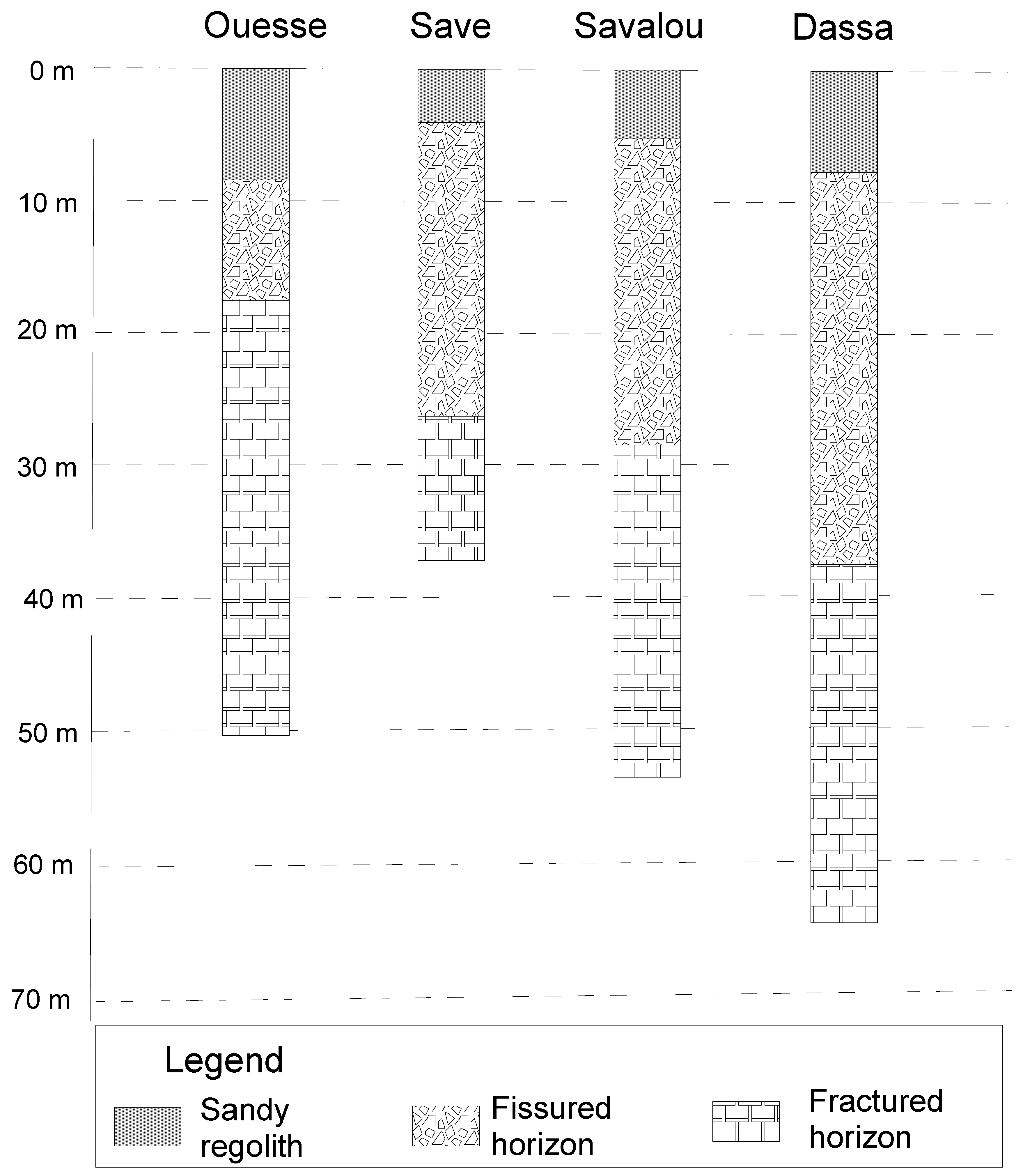
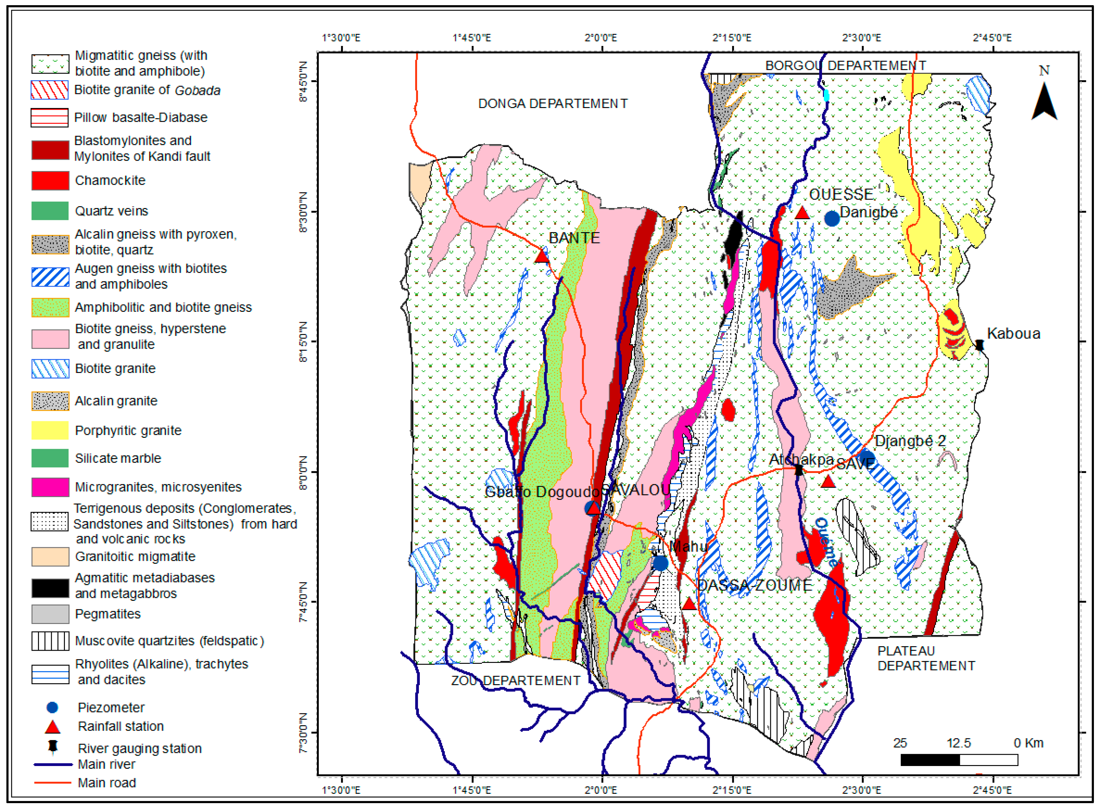
There exist three main Precambrian geological units in the study area. These are migmatitic gneiss, porphyritic gneiss (amphibolitic and biotitic), and granites (Figure 2). There are other less dominant Precambrian geological units such as blastomylonites, biotitic granite, alkaline rhyolites, and alkali granites in the study area. In the south, the Precambrian geological units are overlain by sedimentary formations, with very limited spatial extension (see the terrigenous deposits in Figure 2). Aquifers in the study area are typical of those found in crystalline bedrock regions (refs. [12,13]), with two aquifers: a shallow aquifer found in the weathered regolith (i.e., the sandy regolith and the fissured layer) and a second aquifer found in the deeper fractured and discontinuous zone [14].
In 61% of the existing boreholes, the thickness of the weathered rock (regolith) is between 10 and 20 m [8]. The regolith thickness is lower than 10 m in 31% of the existing boreholes. The regolith thickness is higher than 20 m for approximately 8% of the existing boreholes. Nearly 20% of the existing boreholes go dry by the peak of the dry seasons [15]. Among the boreholes that go dry, about 75% display regolith thicknesses lower than 10 m, and only few (~10%) display higher regolith thicknesses.

2.2. Methodology

To estimate groundwater recharge, we applied in this investigation the Water Table Fluctuation (WTF) method, which is applicable only to unconfined aquifers including fractured-rock aquifer systems [16]. This requires long-term groundwater level monitoring in piezometers as well as estimates of the specific yield, specific yield being the porosity minus the specific retention (i.e., the portion of water adsorbed to rocks). The WTF method considers that the rise in groundwater level is attributable to recharge (RCH) as expressed in Equation (1).
R C H = d h d t × S y
where R C H is recharge, d h d t is change in water table within a given time, and S y is the specific yield.
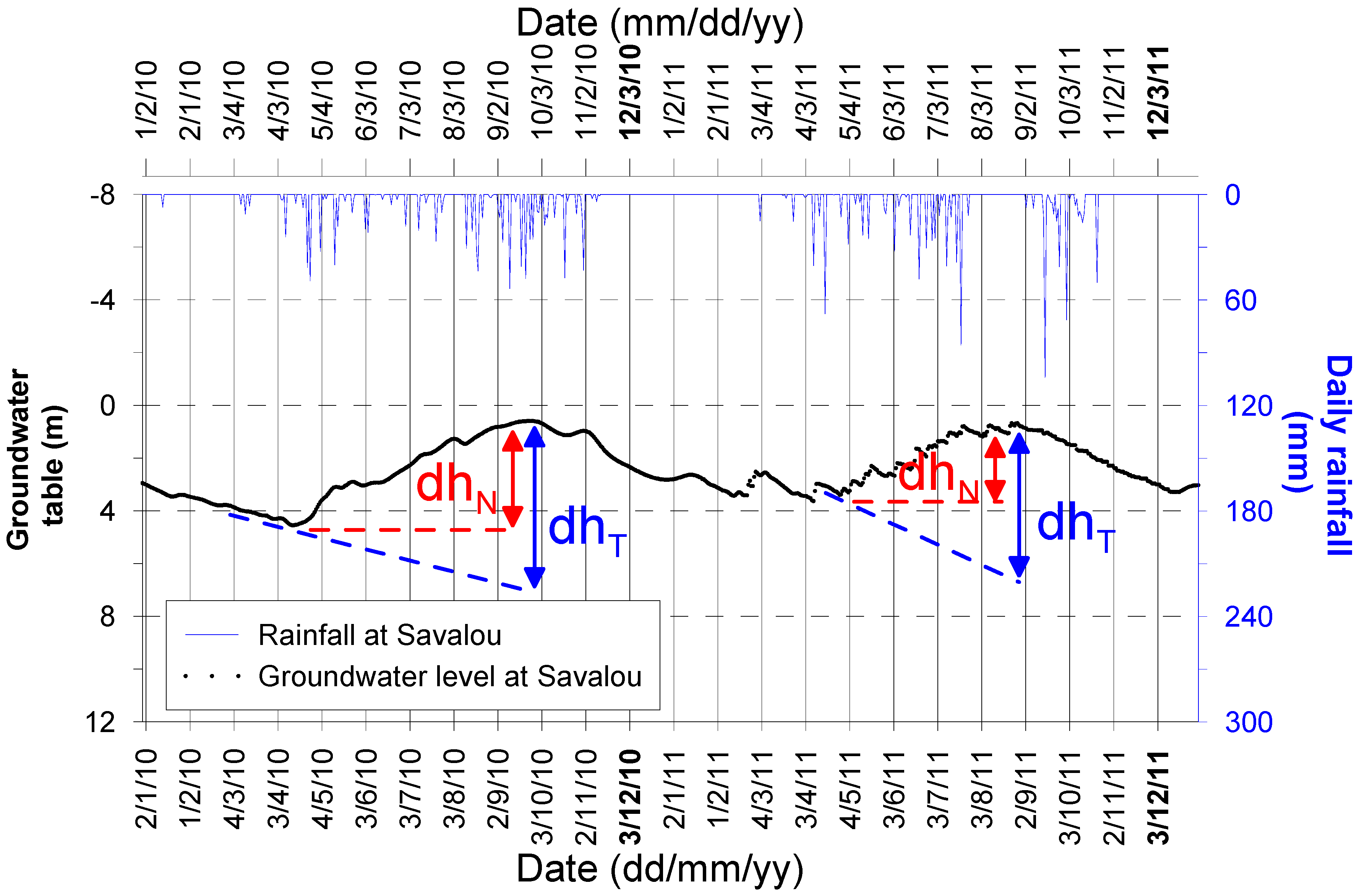
The WTF method can be applied to estimate both total recharge and net recharge [17]. For the total recharge, dh equals the difference between the peak of groundwater rise and the lower point from the extrapolated previous recession curve at the peak time (see blue dash lines (dhT) in Figure 3 and [18]).
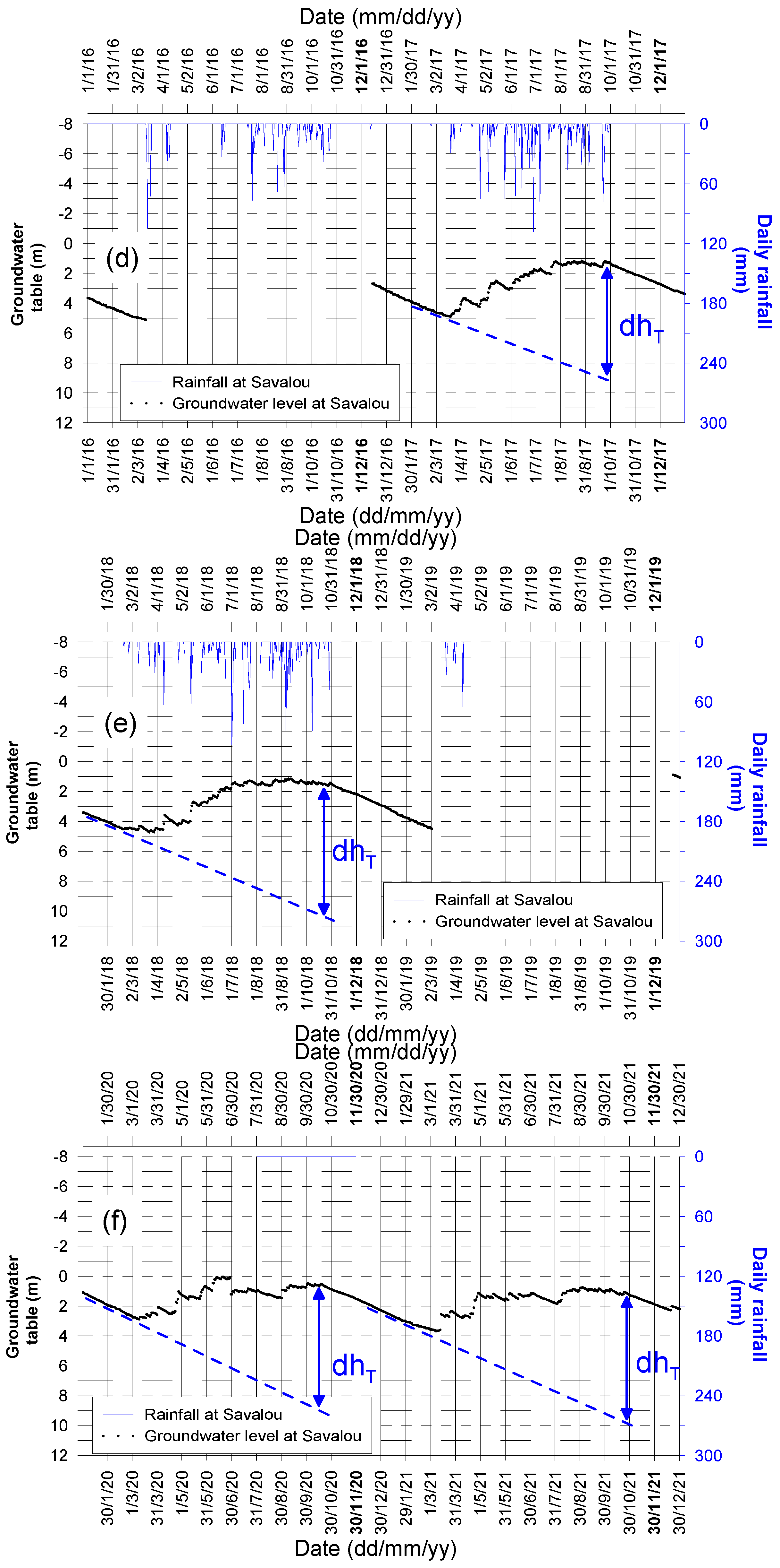
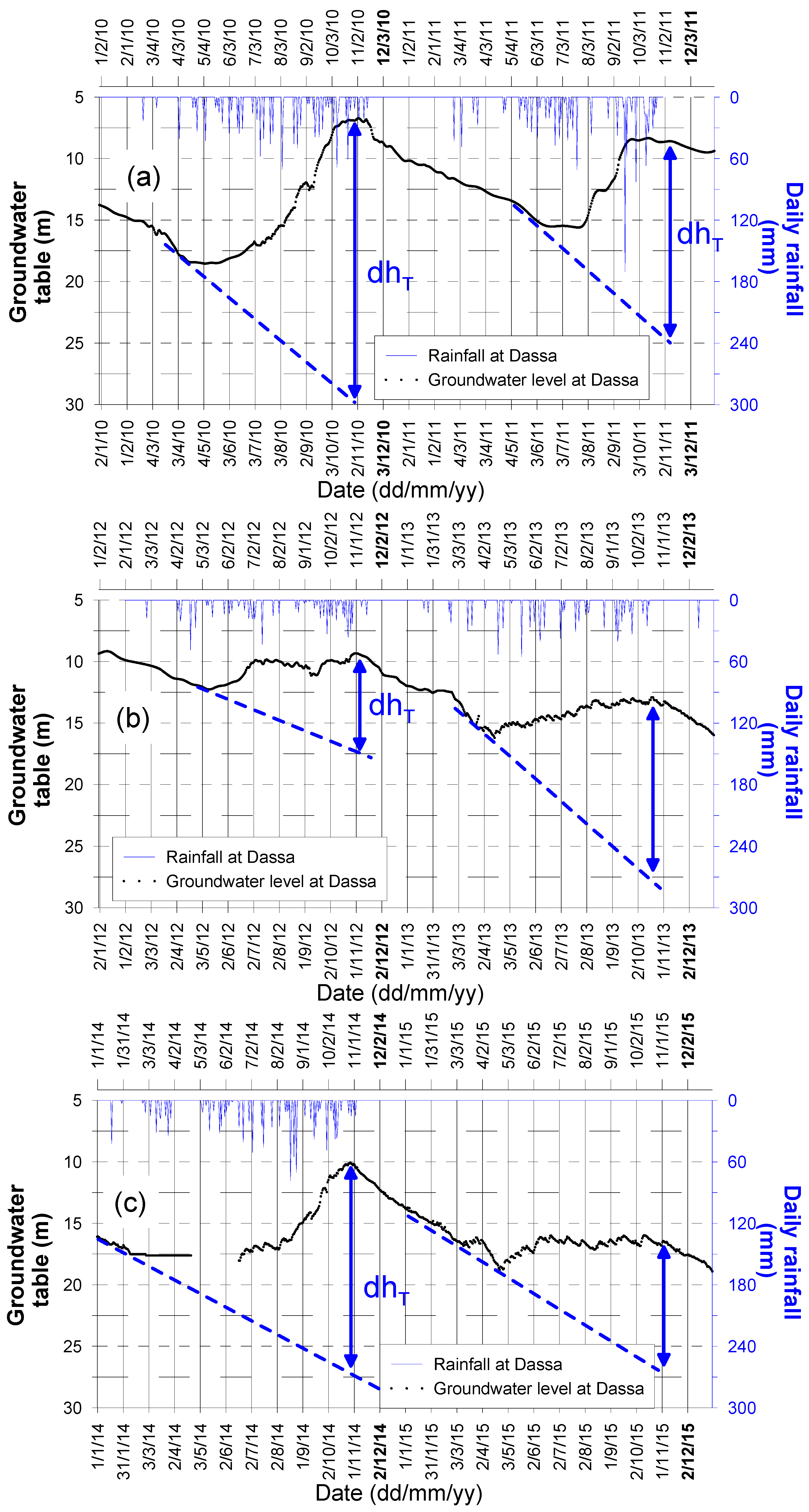
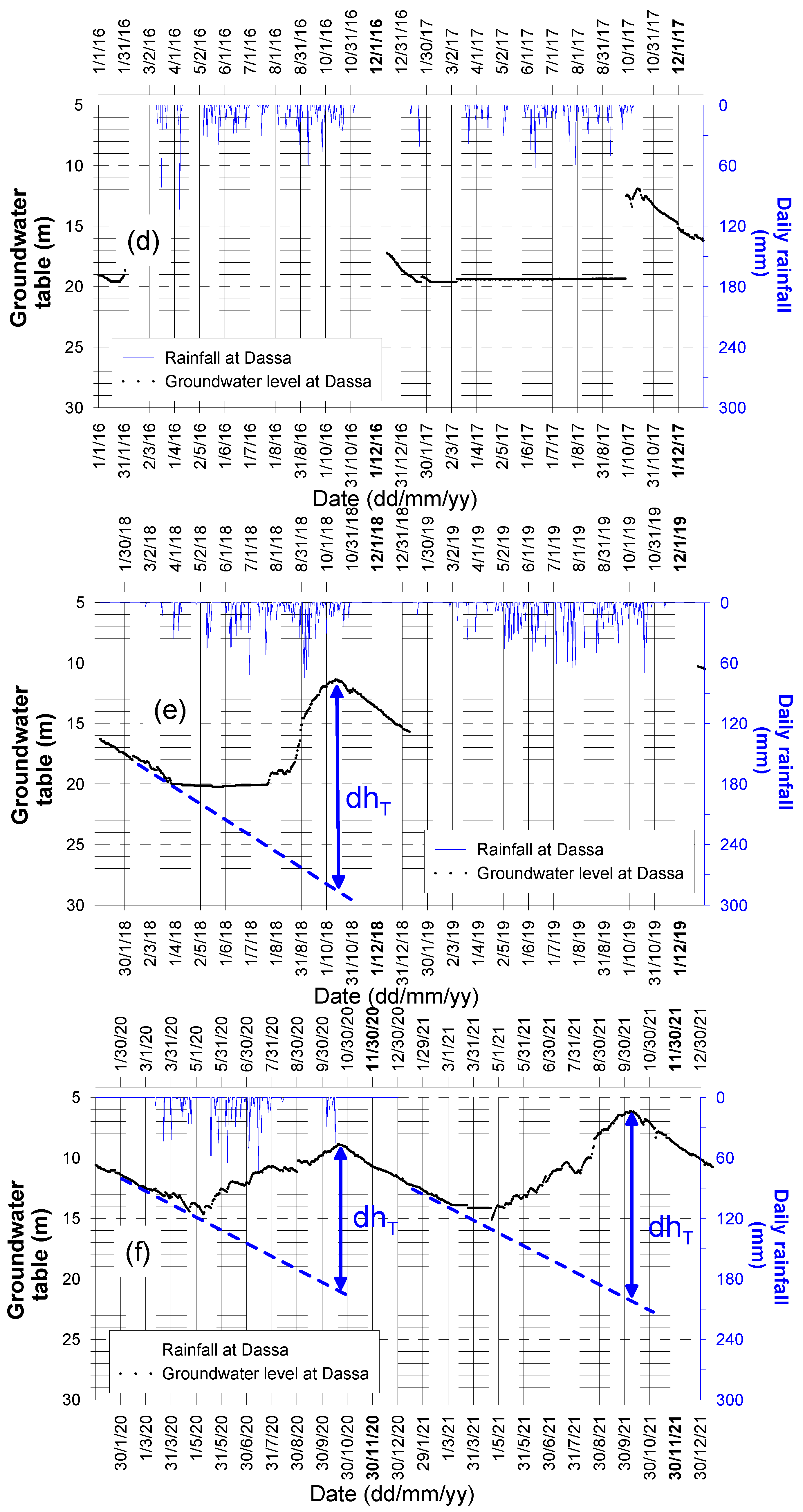
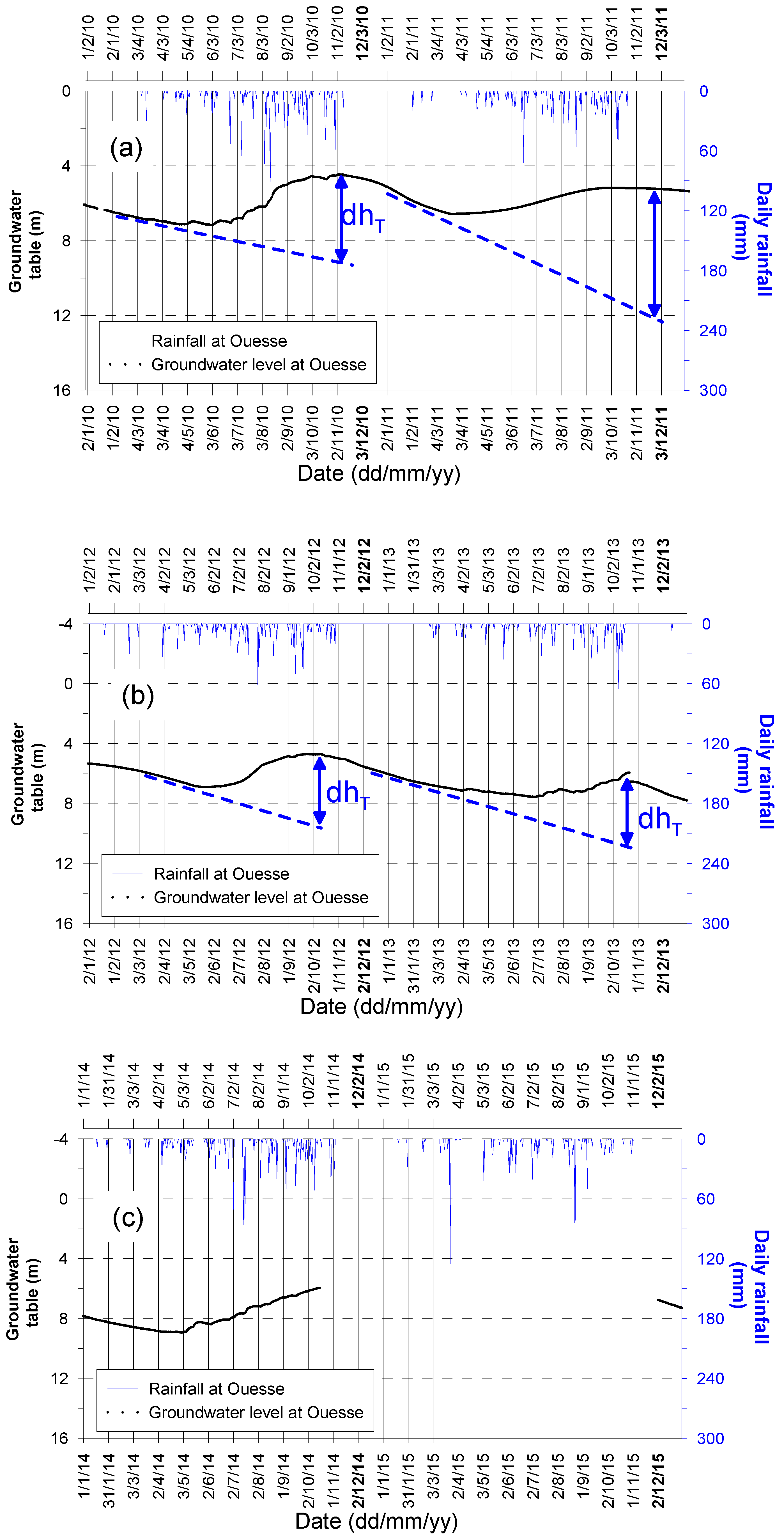
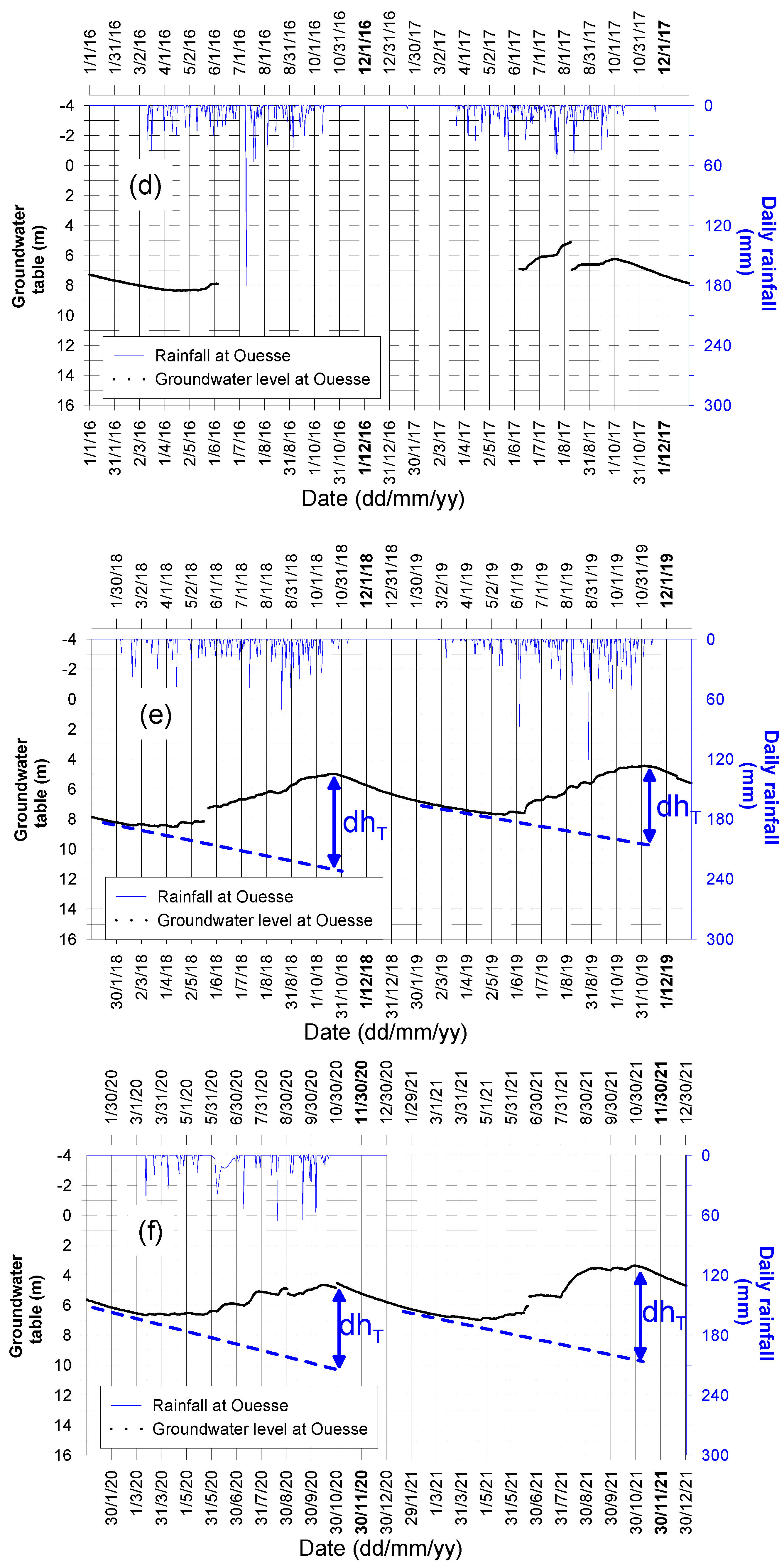
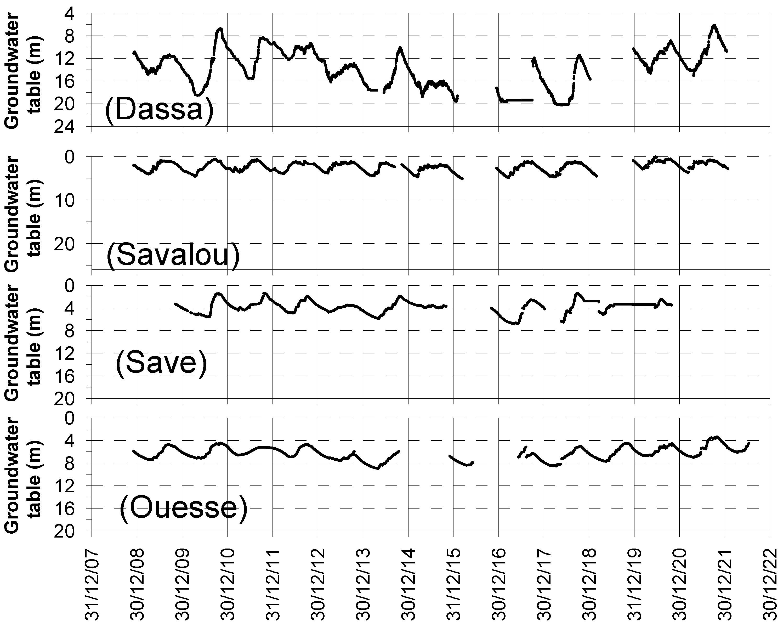
For the net recharge, the height of the groundwater level rise (i.e., the difference between the lowest groundwater level during recession and the peak of the groundwater rise) is applicable (see red dash lines (dhN) in Figure 3). The net recharge neglects other ongoing processes while recharge takes place. Such neglected processes include (1) evapotranspiration from groundwater and (2) groundwater discharge (i.e., baseflow and human abstractions), with human abstractions often being negligible, especially in rural areas, compared to baseflow (see, e.g., ref. [19]). In this study, the total recharge (dhT), as illustrated in Figure 3, was considered. Hence, dhT was estimated annually for all the piezometers, which were monitored for more than a decade (Figure 4). Water level data loggers (i.e., Mini-Diver 20 m from Eijkelkamp, Giesbeek, The Netherlands) were installed in each of the piezometers to allow automatic and continuous recording of water level fluctuations. The data loggers were set to record water level at 02:00 AM each day, with a precision of about 1 cm. However, the data loggers did not work properly, and the water level was not recorded until the next visit of the monitoring team. This explains why there are some missing data in the water level records. The piezometers (monitoring wells) sunk into the fractured horizon, the lower part of the weathered hard-rock aquifer, which is connected to the fissured horizon as well as the sandy regolith. The geographic locations of the piezometers with long groundwater level time series are shown in Figure 2. For each of these piezometers, dhT was estimated following the procedure illustrated in Figure 3. A summary of the graphs from which the estimated dhT were derived is presented in Figure A1, Figure A2, Figure A3 and Figure A4.
In addition to groundwater level amplitudes (changes in groundwater table within a given time), the application of the WTF method requires an estimate of the specific yield. Specific yield is the aquifer’s property that is linked to the pore space available to store recharge. It is obvious that such available pore space is higher in the top layers of hard-rock aquifers (i.e., the saprolite layers including the sandy regolith and the fissured layers) than in the fractured layers underneath [20]. However, existing values of specific yield, often derived from pumping tests, are equivalent values for both layers, taken as composite aquifers [21]. Previous studies (see [22,23]) investigated specific yields of fractured-rock aquifer systems in similar contexts in Benin. Values of specific yield obtained in the similar geological contexts in Benin ranged from 3 to 8%. This range of values was taken into account to arrive at a range of estimated groundwater recharge for each piezometer. For the purpose of discussing the results of groundwater level fluctuations and recharge, rainfall data from existing rainfall stations, the drilling logs of the monitored piezometers, and river discharge data from existing gauging stations within the study area were collected. The locations of the concerned rainfall stations and river gauging stations are shown in Figure 2.
The results of groundwater level fluctuation and groundwater recharge are presented and discussed in the next section.

3. Results

3.1. Groundwater Level Fluctuations in the Study Area

The results show that the annual amplitude of groundwater level varies from one site to another. Namely, the annual groundwater amplitude ranges from 6 to 9 m in Savalou, from 8 to 22 m in Dassa, from 4.6 to 6.9 m in Ouesse, and from 2.6 to 6.7 m in Save (Figure 5). The average annual amplitude of groundwater fluctuations is summarized in Table 1. This average annual amplitude of groundwater level fluctuations is about 5 m at Ouesse and Save, about 7 m at Savalou, and 15 m at Dassa, i.e., more than double the amplitudes found at Ouesse and Save.

3.2. Groundwater Recharge in the Study Area

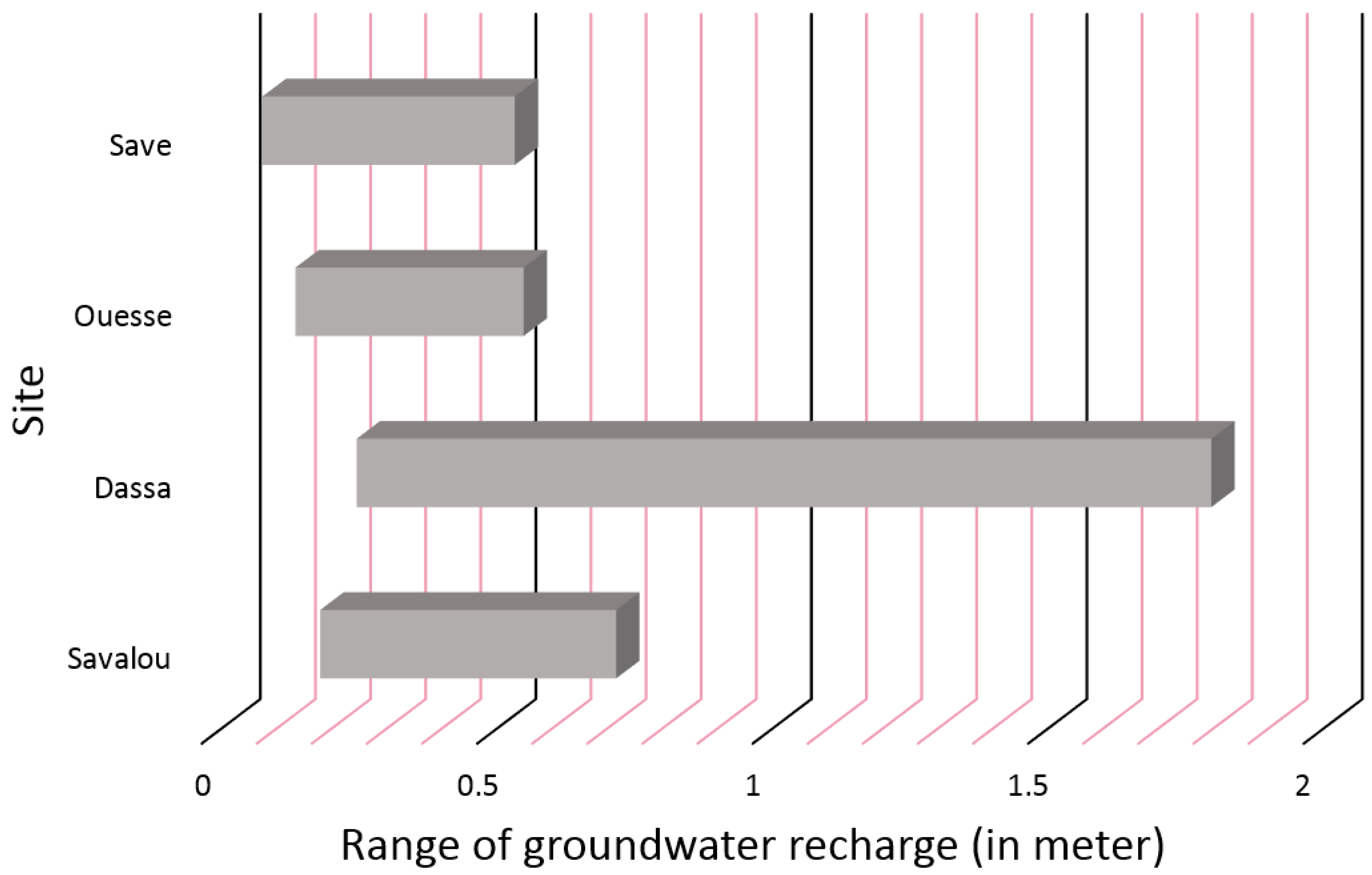
The annual groundwater recharge, estimated for the sites equipped with piezometers, is summarized in Table 2. This is the estimated recharge over the period of 2010 to 2021. It appears that the minimum inter-annual recharge is about 0.183 m, 0.249 m, 0.138 m, and 0.208 m, respectively, at Savalou, Dassa, Ouesse, and Save. The maximum inter-annual groundwater recharge is approximately 0.72 m, 1.392 m, 0.552 m, and 0.536 m, respectively, at Savalou, Dassa, Ouesse, and Save (Table 2).

4. Discussion

4.1. Groundwater Level Fluctuations in the Study Area

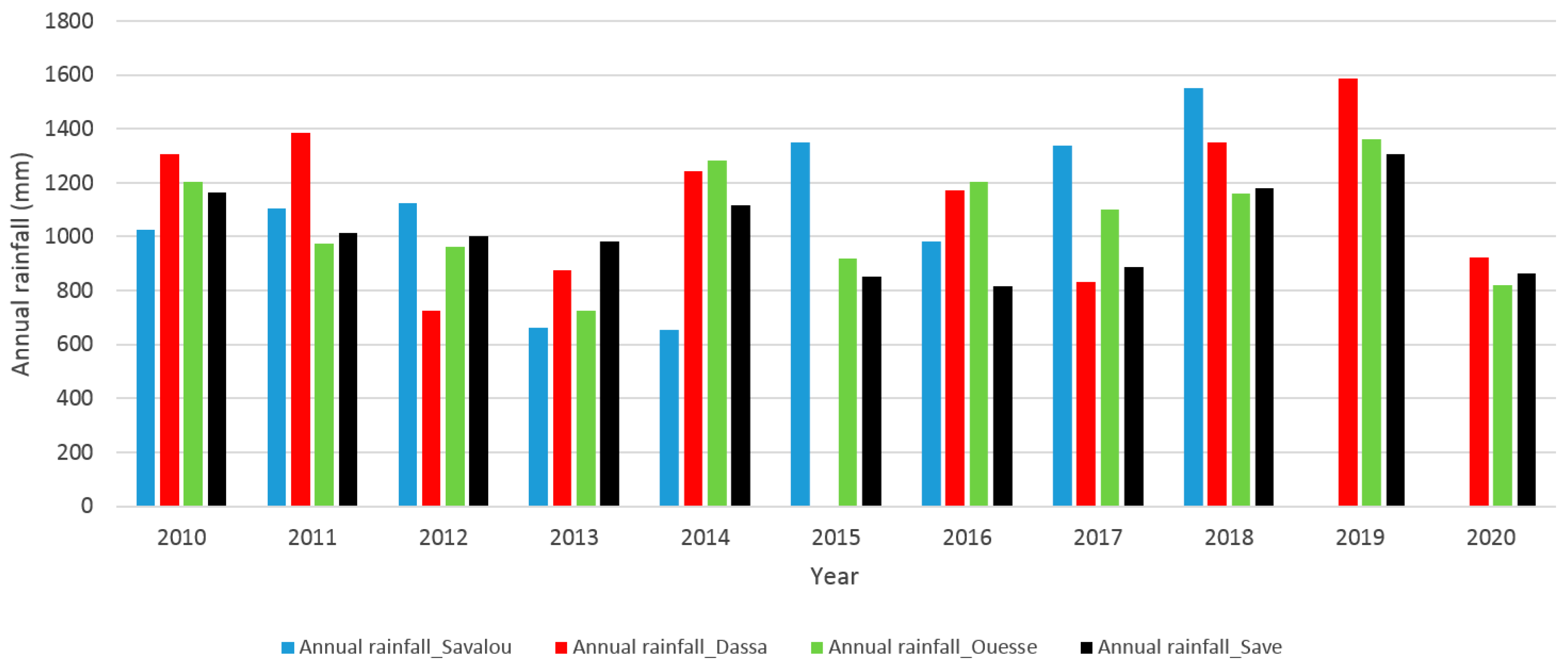
As described in the previous section, the annual amplitudes of groundwater levels range from 6 to 9 m in Savalou, from 8 to 22 m in Dassa, from 4.6 to 6.9 m in Ouesse, and from 2.6 to 6.7 m in Save (Figure 5). On average, the annual amplitude of groundwater level fluctuations (see Table 1) is far higher in Dassa (15 m) compared to the average groundwater level amplitudes in Savalou (7.6 m), in Ouesse (5.53), and in Save (5.23 m). This could be explained by a relatively higher annual rainfall that often occurs at Dassa (Figure 6). Nevertheless, a relatively higher rainfall at Dassa does not fully explain the relatively higher groundwater level amplitude that is observed. As an example, although the annual rainfall was highest at Savalou for the year 2018 (see Figure 6), the amplitude of groundwater level fluctuations was still higher at Dassa that same year. This implies that annual rainfall alone does not determine the groundwater level fluctuations in the study area.
From the drilling logs of the monitored piezometers (see Figure A5), it appears that the saprolite (the sandy regolith and the fissured zone) is thicker (37 m) at the site of Dassa in comparison to the sites of Savalou (28 m), Save (26 m), and Ouesse (17 m). With a thicker weathered rock horizon, one would rather expect lower amplitudes of groundwater levels at Dassa, since a more pronounced rock weathering is associated with higher pore space available to store groundwater, and hence leading logically to lower amplitudes of groundwater level fluctuation. If neither a relatively higher rainfall nor the thickness of the weathered horizon explain the higher fluctuations at Dassa, then a factor that may explain this higher amplitude at Dassa is the drainage density [24]. Often, after rainfall, the groundwater level increases more significantly in regions with low drainage density compared to regions of high drainage density.
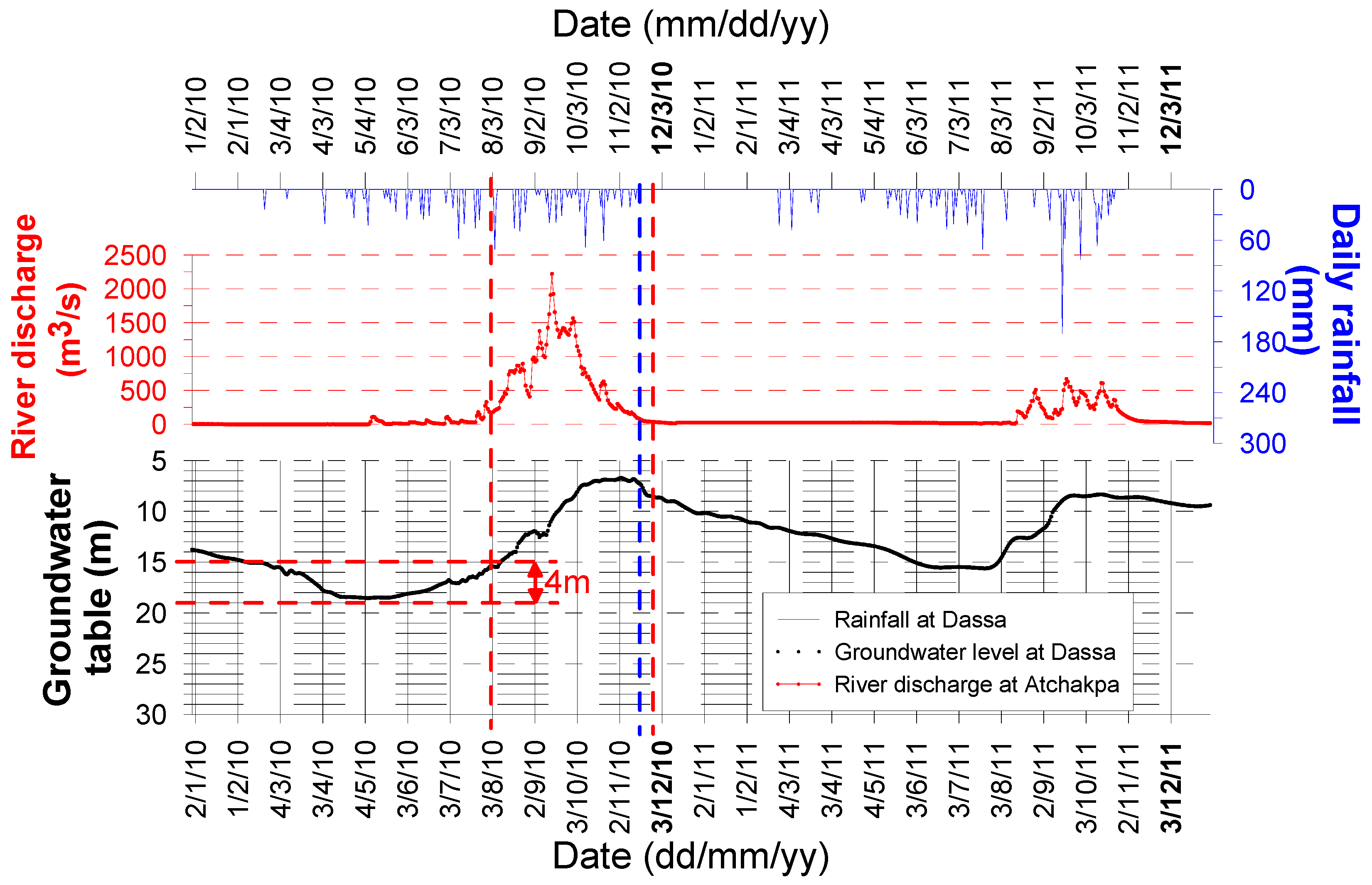
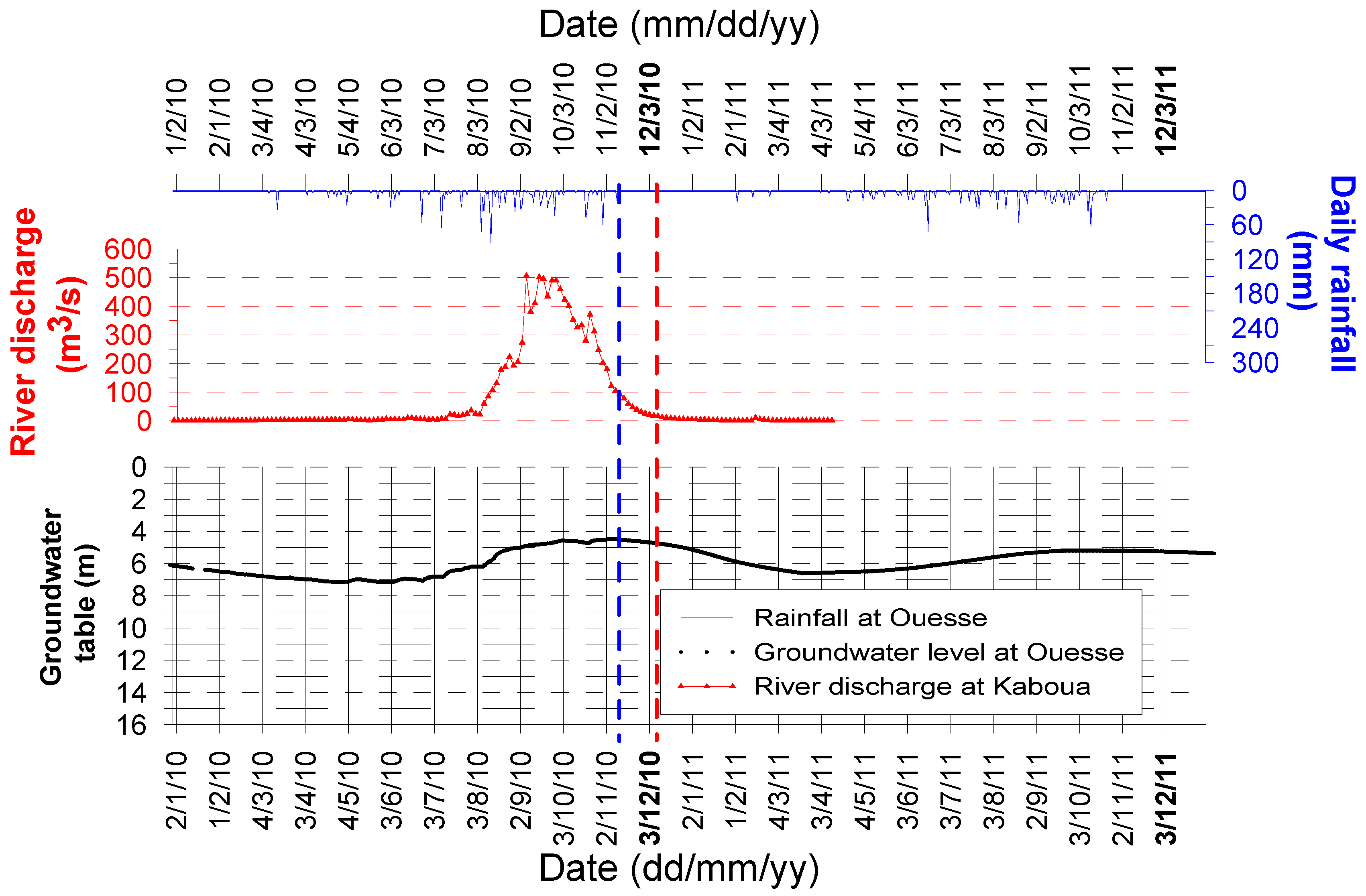
A simultaneous analysis (Figure 7) of rainfall and groundwater level fluctuations at Dassa, coupled with river discharge at Kaboua (nearby Dassa), revealed that few first rainfalls that occur at the onset of the rainy season do not generate an increase in surface water discharge and groundwater level. As shown in Figure 7, few first rainfalls up to early April did not affect river discharge but did attenuate the previously decreasing trend of groundwater level. Additional rainfalls up to the end of July had led to a significant increase (>4 m) in groundwater levels at Dassa (see Figure 7). However, no significant increase in river discharge was observed. This implies that for the area around Dassa, the soil water content is first satisfied, then some groundwater recharge arrives to the water table before significant river discharge occurs. The results reveal that just after the occurrence of the last rainfall of the rainy season (see the example of the period of November 2010 in Figure 7), the decreasing trend in groundwater level starts. It can be concluded that the time lag between the rainfall and groundwater level response is very short (less than two days; see Figure 7). It also appears that the required time for the recharged groundwater to drain down to the baseflow (i.e., the time between the last rainfall (see vertical blue dash line in Figure 7) and the baseflow (red dash line in Figure 7)) is relatively short (about 12 to 14 days, as illustrated in Figure 7). These findings for Dassa are similar to those of Ouesse, except that the time required for the recharged groundwater to drain down to the baseflow is longer at Ouesse (i.e., about 23 to 25 days, as illustrated in Figure 8). The 23 to 25 days corresponds to the time between the last rainfall of the season (see the blue dash line in Figure 8) and the time when the stream flow is reduced to the baseflow (see the red dash line in Figure 8).

4.2. Groundwater Recharge in the Study Area

Overall, the lowest groundwater recharge (i.e., the minimum inter-annual recharge; see Table 2) occurred in 2011 and 2014 at Savalou, in amounts of about 183 mm. At Dassa and Ouesse, the lowest inter-annual groundwater recharge occurred in 2012, in amounts of 249 mm and 138 mm, respectively. The lowest inter-annual groundwater recharge was about 78 mm in Save. This implies that the lowest recharge for all the studied sites did not simultaneously occur in a particular year. The same observation is true for the highest inter-annual recharge because this occurred in Savalou in 2018, whereas it occurred in 2010, 2011, and 2018, respectively, at Dassa, Ouesse, and Save (Table 2). This suggests that, for a given year, while a site is under its lowest recharge state, others may be experiencing a better recharge. Also, there is no particular increasing or decreasing groundwater recharge trend in the study area. For more than a decade, the estimated groundwater recharge ranges from 183 to 720 mm at Savalou, 249 to 1800 mm at Dassa, 138 to 552 mm at Ouesse, and 78 to 536 mm at Save (Figure 9). Hence, over the studied period, the lowest possible annual recharge in the study area is 78 mm, which translates to a groundwater recharge volume of approximately 1.09 × 10⁹ m3, given that the study area is about 13,931 km2. The latter volume is the worst annual groundwater recharge for the studied period. Considering the current population of the study area (~800,000 habitants; see INSAE, 2013), and considering a yearly basic water need of 7300 L/person in rural areas (i.e., 30 L/day/person or 3 × 10⁻² m3/person), it can be concluded that the basic annual need of the population in the study area is ~8784.000 m3, which is less than the worst annual recharge. As such, the recharged groundwater volume is overall enough to cover the basic water needs of the current population. However, such a recharge may not be enough to satisfy the water needs of highly densely populated regions of the studied area. For highly densely populated regions, the implementation of artificial groundwater recharge could be envisaged so as to increase the annual amplitudes of groundwater level fluctuations and to maintain as long as possible the artificially driven high groundwater level.
It should be highlighted that the WTF method applied in this study has some limitations, namely, the limitations linked to the specific yield (Sy), which are discussed by [17]. In line with these limitations, we found that the sites for which the assumed Sy was too high could be easily detected. This was the case for Dassa, for which the maximum estimated recharge went above the rainfall for the year 2010 (Table 2 and Figure 6). This suggests that under uncertain Sy, an extreme (maximum) estimated groundwater recharge should be interpreted with care. Rather, the average estimated recharge would be more meaningful.

4.3. General Limitations of Studies Applying the WTF Method for Groundwater Recharge Estimation

This study successfully assessed groundwater recharge in the targeted study area but may have some limitations linked to the applied WTF method. Usually, when applying the WTF method, one difficulty is identifying the causes of water level fluctuations. Multiple causes could explain a groundwater level rise in an aquifer, including the influx of groundwater from an adjacent groundwater basin. If any groundwater influx from an adjacent basin occurs, the amounts of the groundwater influx are in reality difficult to measure with precision. Such imprecisions might lead to uncertainties in the estimated groundwater recharge. For the present case study, groundwater influx from an adjacent groundwater system is not applicable, since rainfalls fully explain groundwater level rises, as shown in Figure 3 and Figure 7 and in Appendix A. Another issue is that the WTF method is not able to account for steady recharge rates. Basically, when the recharge rate is constant and equal, the drainage from the water table (or groundwater outflux such as groundwater abstractions), will remain unchanged, and the WTF method would wrongly predict no recharge. Uncertainties attached to the value of the specific yield remain a limitation of the WTF method [25]. The values of specific yield used in this study were quantified based on Magnetic Resonance Sounding (MRS), which is a non-invasive geophysical method [22]. Namely, MRS results (i.e., the water content and pore size parameter) were calibrated against the specific yield derived from long-duration pumping tests). Then, it was possible to estimate the specific yield based on the MRS results. According to the authors, the uncertainties linked to the implemented values of specific yield are about 10%.

5. Conclusions

The aim of this study was to assess groundwater recharge in the hard-rock region of the “département des collines” in central Benin. For this aim, we applied the Water Table Fluctuation method. In addition, rainfall data, drilling log data of existing piezometers, and rainfall data were analyzed so as to shed further light on the relationship between surface water and groundwater in the study area. We found that annual amplitudes of groundwater level fluctuations are highest in the sub-region called Dassa, which is explained by a relatively higher rainfall coupled with lower drainage density. It also appeared that around Dassa the first rainfall at the onset of the rainy season tends to generate some groundwater recharge prior to the occurrence of surface water discharge. The results have also demonstrated that the time lag between the rainfall and groundwater level response is as short as two days around Dassa. Further, the results showed that it takes about 14 days for the recharge groundwater to drain down to the stream baseflow around Dassa. However, this takes longer (~25 days) in the sub-region called Ouesse. The estimated groundwater recharge for the studied period (over a decade) did not display any particular increasing or decreasing trend in the study area. The lowest inter-annual groundwater recharge volume is about 1.09 × 10⁹ m3, which is enough to satisfy the basic needs of the current population. However, in highly densely populated sub-regions, this minimum annual groundwater recharge amount might still be insufficient.
This study is the very first to investigate groundwater recharge in the study area. The merits of this study are that it used real and long-term time series data to estimate recharge and to assess the groundwater resource availability with respect to the basic water needs of the population. Moreover, it has shown that with the application of the WTF method, inconsistent values of specific yield can be detected.

Author Contributions

All the authors contributed to the conception and design of this study on groundwater recharge assessment. K.A.R.K., F.A. and J.H. wrote the first draft of the methodology and results. C.A., M.B.D., Y.N.M., A.Y.B. and A.A. wrote the first draft of the discussion. L.O.S., D.M. and M.B. contributed to the design of the graphs and to drafting the first version of the introduction, conclusion, and references. All authors have read and agreed to the published version of the manuscript.

Funding

Funding for this study was from the C2EA (Centre d’Excellence d’Afrique pour l’Eau et l’Assainissement).

Data Availability Statement

The data are available upon request from the authors.

Acknowledgments

We thank the DGEau (Direction Générale de l’Eau) of the Republic of Benin for facilitating data acquisition.

Conflicts of Interest

The authors declare no conflicts of interest.

Appendix A

Figure A1. Detailed annual estimation of dh at Savalou over a decade (af).
Water 16 01330 g0a1aWater 16 01330 g0a1b
Figure A2. Detailed annual estimation of dh at Dassa over a decade (af).
Water 16 01330 g0a2aWater 16 01330 g0a2b
Figure A3. Detailed annual estimation of dh at Ouesse over a decade (af).
Water 16 01330 g0a3aWater 16 01330 g0a3b
Figure A4. Detailed annual estimation of dh at Save over a decade (af).
Water 16 01330 g0a4aWater 16 01330 g0a4b
Figure A5. Drilling logs of the monitored piezometers in the study area.
Water 16 01330 g0a5

References

  1. MacDonald, A.M.; Bonsor, H.C.; Dochartaigh, B.É.Ó.; Taylor, R.G. Quantitative maps of groundwater resources in Africa. Environ. Res. Lett. 2012, 7, 024009. [Google Scholar] [CrossRef]
  2. Priyan, K. Issues and Challenges of Groundwater and Surface Water Management in Semi-Arid Regions. In Groundwater Resources Development and Planning in the Semi-Arid Region; Pande, C.B., Moharir, K.N., Eds.; Springer: Cham, Switzerland, 2021. [Google Scholar] [CrossRef]
  3. Li, H.; Han, S.; Wu, X.; Wang, S.; Liu, W.; Ma, T.; Zhang, M.; Wei, Y.; Yuan, F.; Yuan, L.; et al. Distribution, characteristics and influencing factors of fresh groundwater resources in the Loess Plateau, China. China Geol. 2021, 4, 509–526. [Google Scholar] [CrossRef]
  4. Rodhe, A.; Bockgård, N. Groundwater recharge in a hard rock aquifer: A conceptual model including surface-loading effects. J. Hydrol. 2006, 330, 389–401. [Google Scholar] [CrossRef]
  5. Conicelli, B.; Hirata, R.; Galvão, P.; Bernardino, M.; Simonato, M.; Abreu, M.C.; Aranda, N.; Terada, R. Determining groundwater availability and aquifer recharge using GIS in a highly urbanized watershed. J. S. Am. Earth Sci. 2021, 106, 103093. [Google Scholar] [CrossRef]
  6. INSAE. Résultats Provisoires du 4eme Recensement Général de la Population et de l’Habitat (RGPH4); Ministère du Développement, de l’Analyse Economique et de la Prospective: Cotonou, Benin, 2013. [Google Scholar]
  7. Tossou, Y.Y.J.; Orban, P.; Gesels, J.; Otten, J.; Yessoufou, S.; Boukari, M.; Brouyere, S. Hydrogeochemical mechanisms governing the mineralization and elevated fluoride (F) contents in Precambrian crystalline aquifer groundwater in central Benin, Western Africa. Environ. Earth Sci 2017, 76, 691. [Google Scholar] [CrossRef]
  8. Koumassi, H. Facteurs Explicatifs Du Tarissement Des Points D’eau En Milieu De Socle Cristallin Dans Le Département Des Collines Au Benin. Eur. Sci. J. 2017, 13, 1857–7881. [Google Scholar] [CrossRef]
  9. Oloukoi, J.; Mama, V.J.; Agbo, F.B. Modélisation de la dynamique de l’occupation des terres dans le département des Collines au Bénin. Télédétection 2006, 6, 305–323. [Google Scholar]
  10. Hounkpè, J.; Diekkrüger, B.; Badou, D.; Afouda, A. Change in Heavy Rainfall Characteristics over the Ouémé River Basin, Benin Republic, West Africa. Climate 2016, 4, 15. [Google Scholar] [CrossRef]
  11. N’Tcha M’Po, Y.; Lawin, E.; Yao, B.; Oyerinde, G.; Attogouinon, A.; Afouda, A. Decreasing Past and Mid-Century Rainfall Indices over the Ouémé River Basin, Benin (West Africa). Climate 2017, 5, 74. [Google Scholar] [CrossRef]
  12. Anaba Onana, A.B.; Ndam Ngoupayou, J.R.; Mvondo Ondoa, J. Analysis of crystalline bedrock aquifer productivity: Case of central region in Cameroon. Groundw. Sustain. Dev. 2017, 5, 66–74. [Google Scholar] [CrossRef]
  13. Maurice, L.; Taylor, R.G.; Tindimugaya, C.; MacDonald, A.M.; Johnson, P.; Kaponda, A.; Gooddy, D. Characteristics of high-intensity groundwater abstractions from weathered crystalline bedrock aquifers in East Africa. Hydrogeol. J. 2018, 27, 459–474. [Google Scholar] [CrossRef]
  14. Boukari, M. Contribution à L’étude Hydrogéologique des Régions de Socle de l’Afrique Intertropicale: L’Hydrogéologie de la Région de Dassa-Zoume’ (Bénin). Ph.D. Thesis, Université de Dakar, Dakar, Senegal, 1982. [Google Scholar]
  15. El-Fahem, T. Hydrogeological Conceptualisation of a Tropical River Catchment in a Crystalline Basement Area and Transfer into a Numerical Groundwater Flow Model: Case Study for the Upper Ouémé Catchment in Benin. Ph.D. Thesis, Bonn University, Bonn, Germany, 2008. [Google Scholar]
  16. Scanlon, B.R.; Healy, R.W.; Cook, P.G. Choosing appropriate techniques for quantifying groundwater recharge. Hydrogeol. J. 2002, 10, 18–39. [Google Scholar] [CrossRef]
  17. Healy, R.W.; Cook, P.G. Using groundwater levels to estimate recharge. Hydrogeol. J. 2002, 10, 91–109. [Google Scholar] [CrossRef]
  18. Delin, G.N.; Healy, R.W.; Lorenz, D.L.; Nimmo, J.R. Comparison of local- to regional-scale estimates of ground-water recharge in Minnesota, USA. J. Hydrol. 2007, 334, 231–249. [Google Scholar] [CrossRef]
  19. Vouillamoz, J.M.; Lawson, F.M.A.; Yalo, N.; Descloitres, M. Groundwater in hard rocks of Benin: Regional storage and buffer capacity in the face of change. J. Hydrol. 2015, 520, 379–386. [Google Scholar] [CrossRef]
  20. Durand, V.; Léonardi, V.; de Marsily, G.; Lachassagne, P. Quantification of the specific yield in a two-layer hard-rock aquifer model. J. Hydrol. 2017, 551, 328–339. [Google Scholar] [CrossRef]
  21. Lachassagne, P.; Wyns, R.; Dewandel, B. The fracture permeability of hard rock aquifers is due neither to tectonics, nor to unloading, but to weathering processes. Terra Nova 2011, 23, 145–161. [Google Scholar] [CrossRef]
  22. Vouillamoz, J.M.; Lawson, F.M.A.; Yalo, N.; Descloitres, M. The use of magnetic resonance sounding for quantifying specific yield and transmissivity in hard rock aquifers: The example of Benin. J. Appl. Geophys. 2014, 107, 16–24. [Google Scholar] [CrossRef]
  23. Kotchoni, V.; Vouillamoz, J.M.; Boukari, M.; Adihou, C. Estimation de la Recharge des Aquifères de Socle au Bénin: Approche Couplée Hydrochimique et Piézométrique. Vingtièmes Journées Techniques du Comité Français d’Hydrogéologie de l’Association Internationale des Hydrogéologues, «Aquifères de Socle: Le Point sur les Concepts et les Applications Opérationnelles» La Roche-sur-Yon. 2015. Available online: https://www.cfh-aih.fr/colloques-et-visites/tous-les-colloques-et-visites/78-colloque-socle-2015.html (accessed on 19 February 2024).
  24. Rajaveni, S.P.; Brindha, K.; Rajesh, R.; Elango, L. Spatial and Temporal Variation of Groundwater Level and its Relation to Drainage and Intrusive Rocks in a part of Nalgonda District, Andhra Pradesh, India. J. Indian Soc. Remote Sens. 2014, 42, 765–776. [Google Scholar] [CrossRef]
  25. Delottier, H.; Pryet, A.; Lemieux, J.M.; Dupuy, A. Estimating groundwater recharge uncertainty from joint application of an aquifer test and the water-table fluctuation method. Hydrogeol. J. 2018, 26, 2495–2505. [Google Scholar] [CrossRef]
Figure 1. Location and topographic map of the study area.
Water 16 01330 g001
Figure 2. Geology map of the study area showing the locations of piezometers, rainfall stations, and river gauging stations (modified from [7]).
Water 16 01330 g002
Figure 3. Illustration of dh estimation for the case of the piezometer of Savalou.
Water 16 01330 g003
Figure 4. Time series of groundwater level fluctuations in the study area. The geographic locations of the piezometers are shown in Figure 2. Note that the time series include missing data.
Water 16 01330 g004
Figure 5. Annual groundwater level amplitudes in the study area.
Water 16 01330 g005
Figure 6. Distribution of annual rainfall in the study area.
Water 16 01330 g006
Figure 7. Groundwater level fluctuation in comparison to rainfall and surface water discharge at Dassa.
Water 16 01330 g007
Figure 8. Groundwater level fluctuation in comparison to rainfall and surface water discharge at Ouesse.
Water 16 01330 g008
Figure 9. Range of estimated groundwater recharge over a decade (2010 to 2021) in the study area.
Water 16 01330 g009
Table 1. Statistics of the amplitudes of groundwater level fluctuations in the study area.
dh (In m)
YeardhT_SavaloudhT_DassadhT_OuessedhT_Save
20106.222.54.75.1
20116.116.36.96.1
20127.58.34.65.1
20137.915.24.83.7
20146.117.2 6.1
20158.210.5 2.6
2016
20177.9 6.5
2018917.46.26.7
2019 5.2
20208.3125.5
20218.815.66.4
Annual minimum (2010–2021)6.18.34.62.6
Annual maximum (2010–2021)922.56.96.7
Annual average (2010–2021)7.6155.53755.2375
Table 2. Annual estimated recharge in the study area.
Recharge at Savalou (In m)Recharge at Dassa (In m)Recharge at Ouesse (In m)Recharge at Save (In m)
YearMinMaxMinMaxMinMaxMinMax
20100.1860.4960.6751.80.1410.3760.1530.408
20110.1830.4880.4891.3040.2070.5520.1830.488
20120.2250.60.2490.6640.1380.3680.1530.408
20130.2370.6320.4561.2160.1440.3840.1110.296
20140.1830.4880.5161.376 0.1830.488
20150.2460.6560.3150.84 0.0780.208
2016
20170.2370.632 0.1950.52
20180.270.720.5221.3920.1860.4960.2010.536
2019 0.1560.416
20200.2490.6640.360.960.1650.44
20210.2640.7040.4681.2480.1920.512
Disclaimer/Publisher’s Note: The statements, opinions and data contained in all publications are solely those of the individual author(s) and contributor(s) and not of MDPI and/or the editor(s). MDPI and/or the editor(s) disclaim responsibility for any injury to people or property resulting from any ideas, methods, instructions or products referred to in the content.