

Estimating Stage-Frequency Curves for Engineering Design in Small Ungauged Arctic Watersheds
 , , ,
, , ,
Abstract
1. Introduction
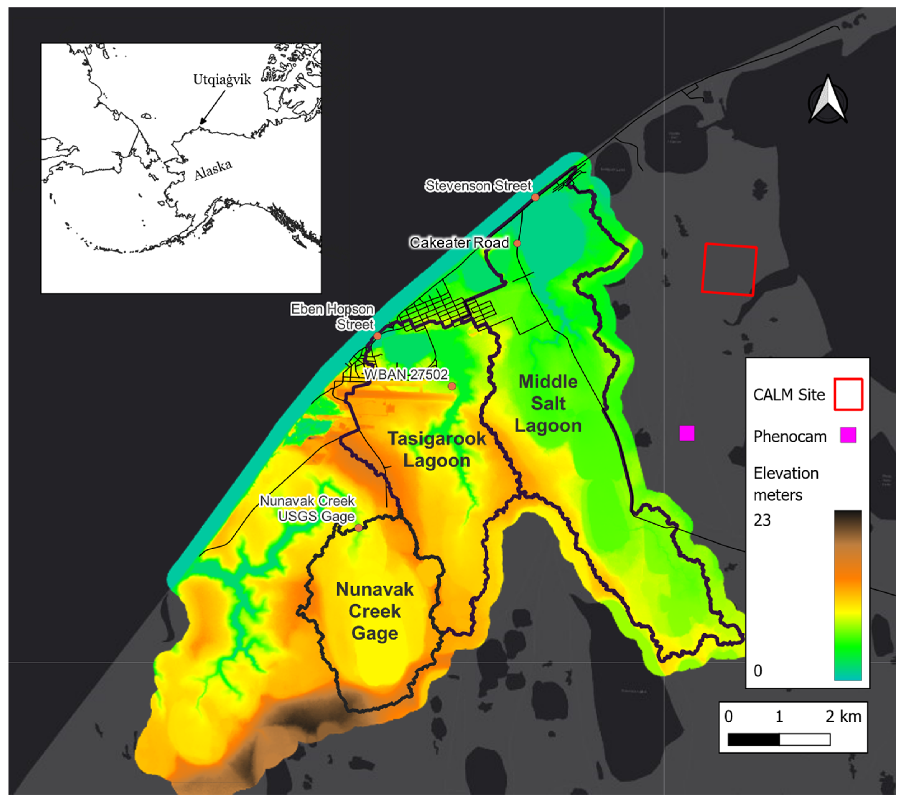
Study Area
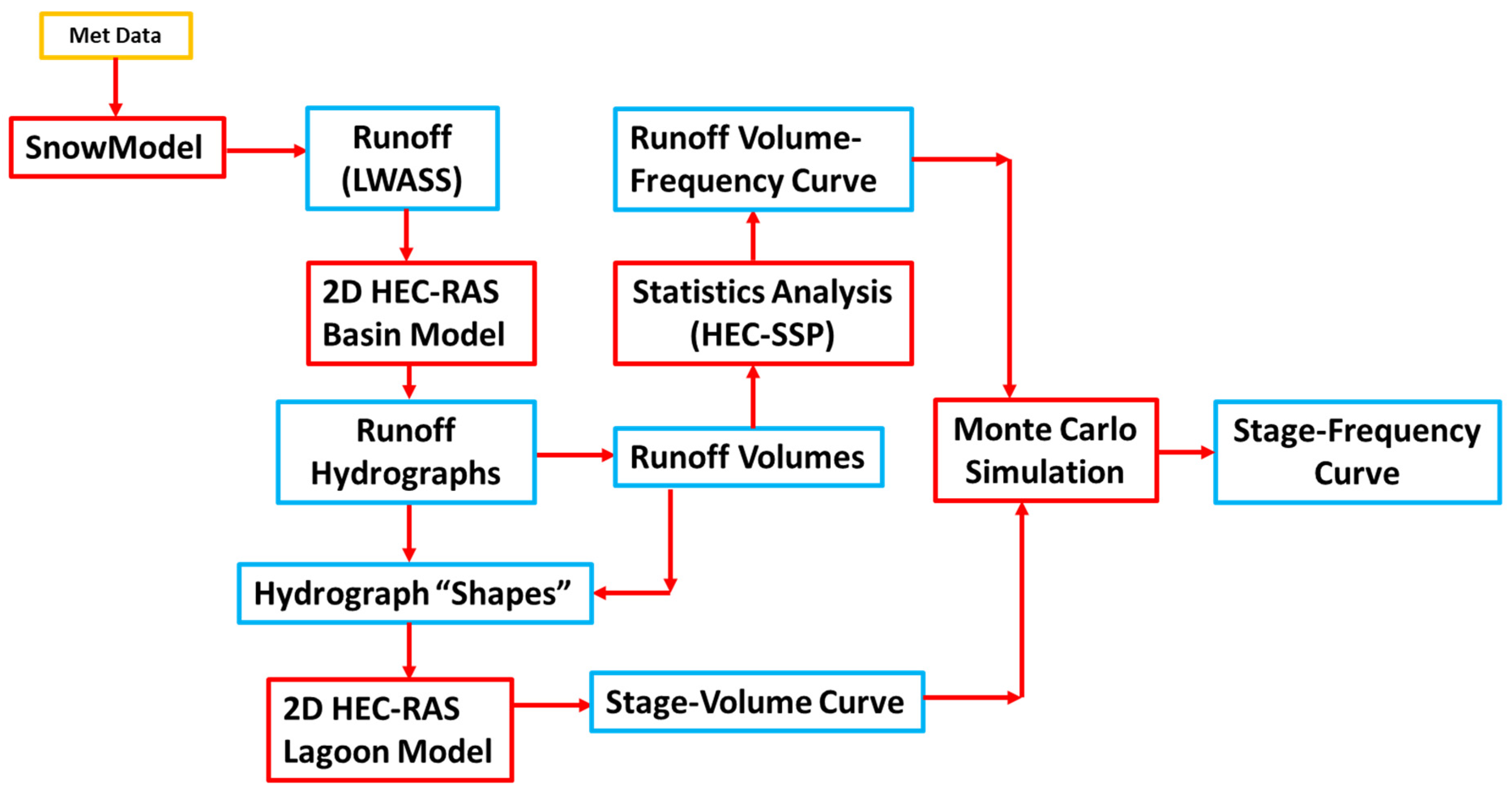
2. Materials and Methods
2.1. Snow Accumulation and Ablation
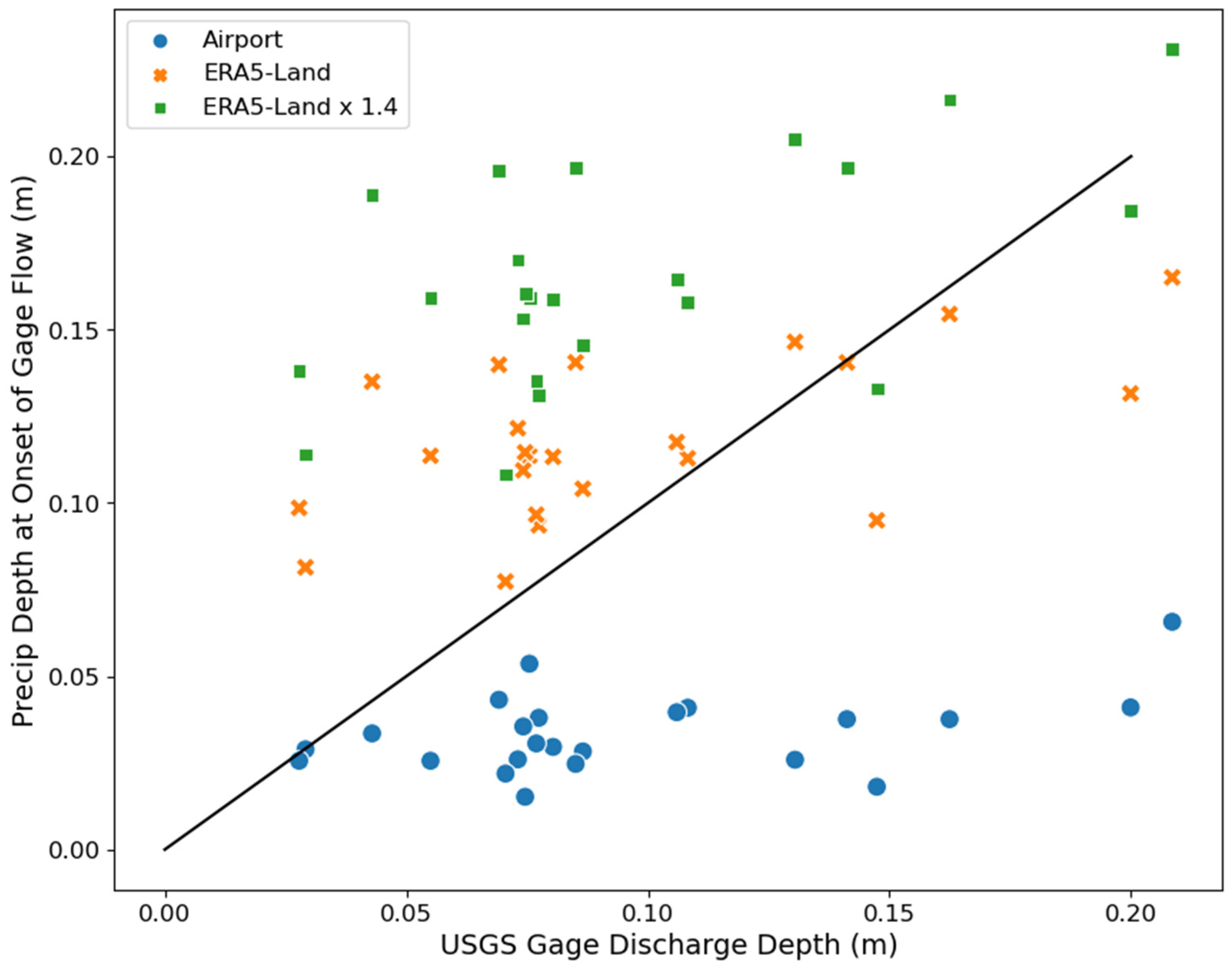
2.2. Snowmelt Runoff
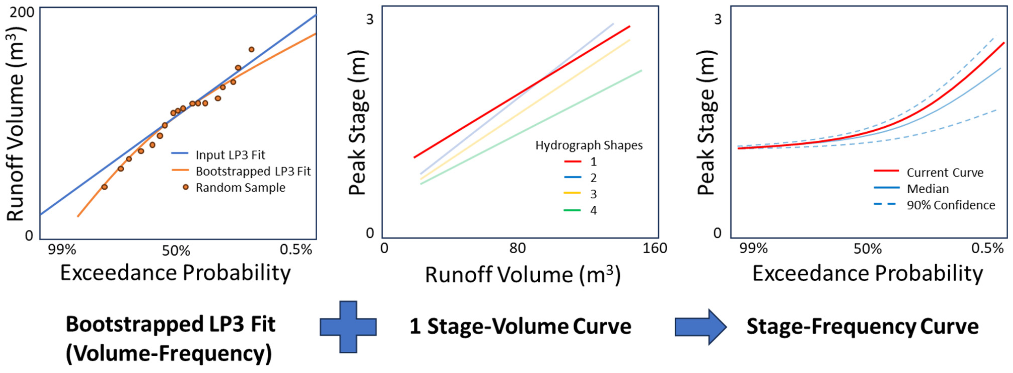
2.3. Stage Frequency and Uncertainty
- is the edge of a confidence interval around the expected value for a given α,
- S is the standard deviation of the metric,
- is the mean of the metric, and N is the sample size. α was set at 10% (setting confidence intervals at 90%) and the error tolerance was set at 2%.
3. Results
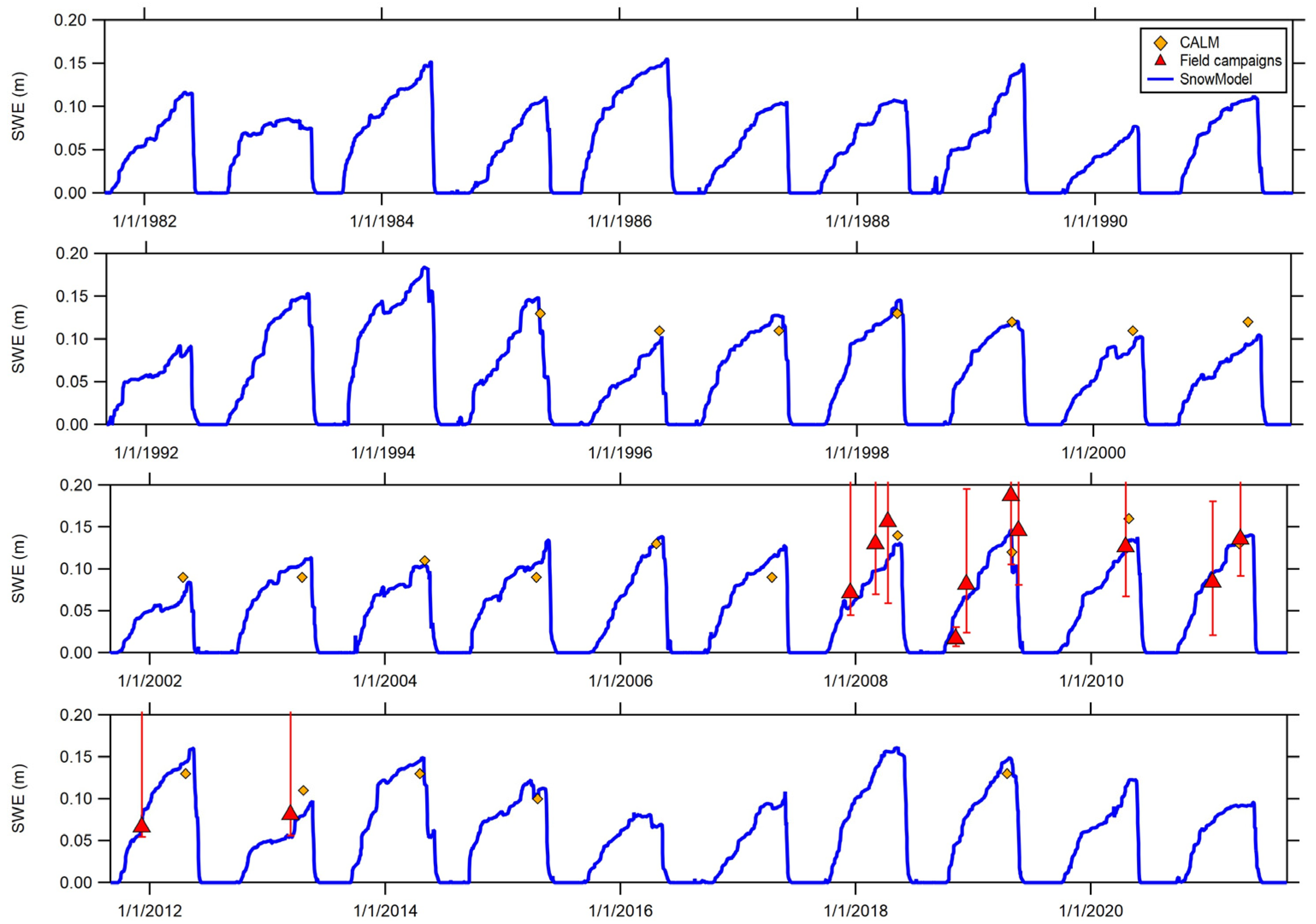
3.1. Snow Accumulation and Ablation
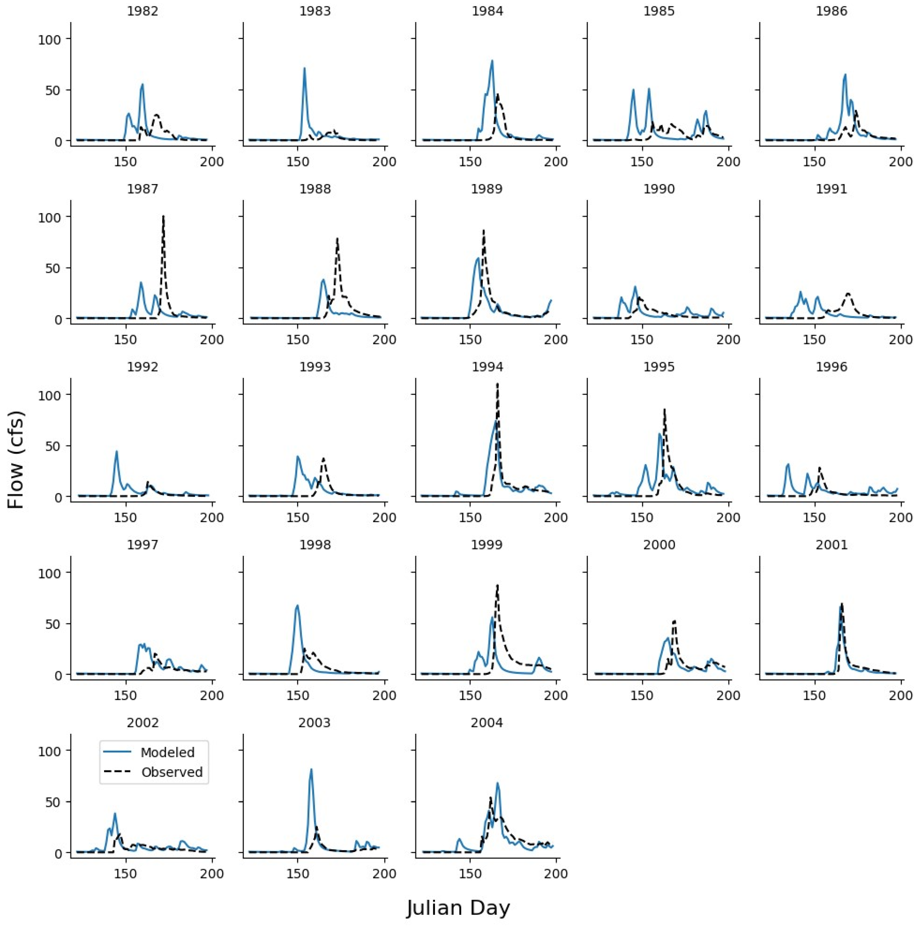
3.2. Snowmelt Runoff
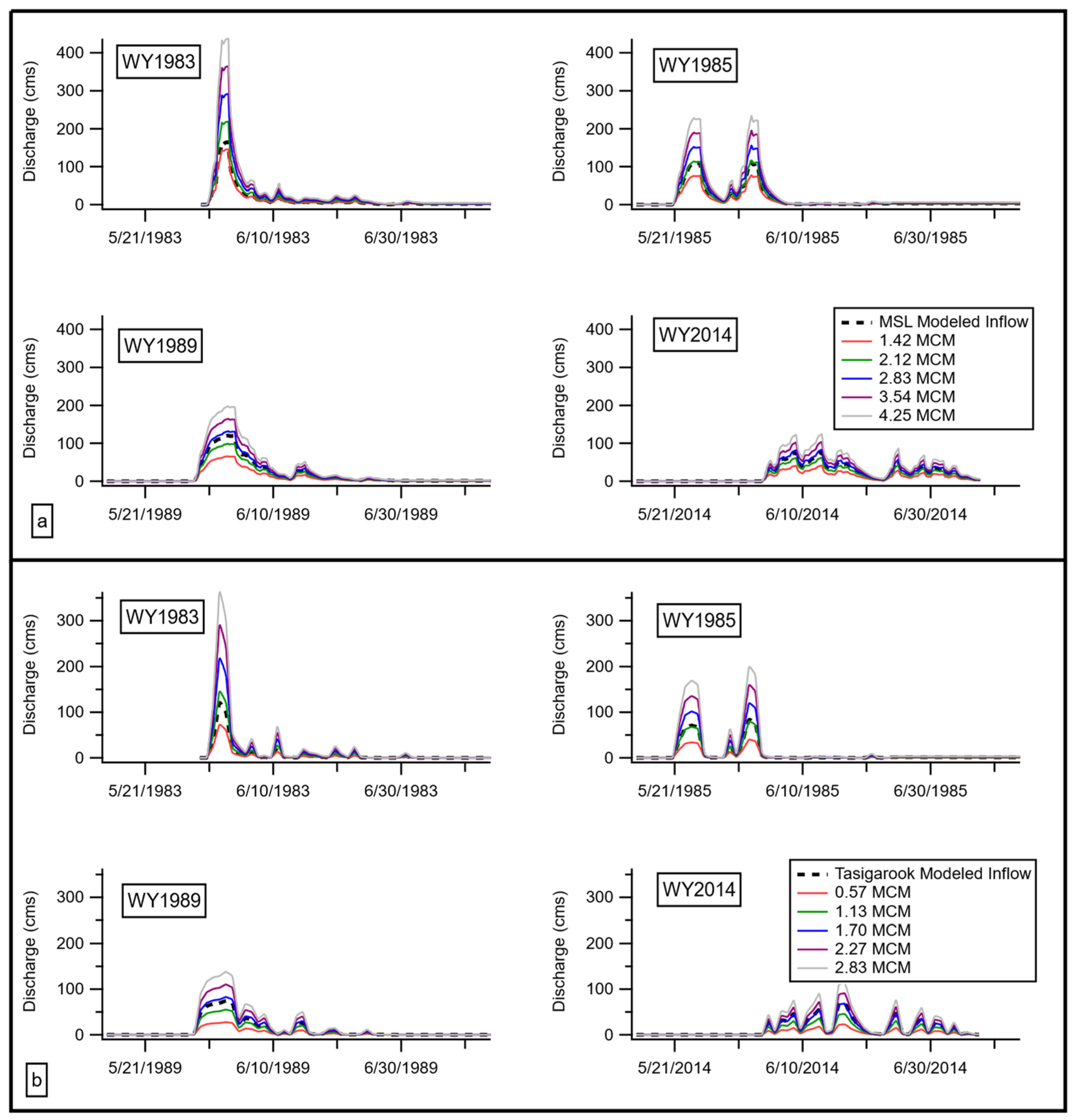
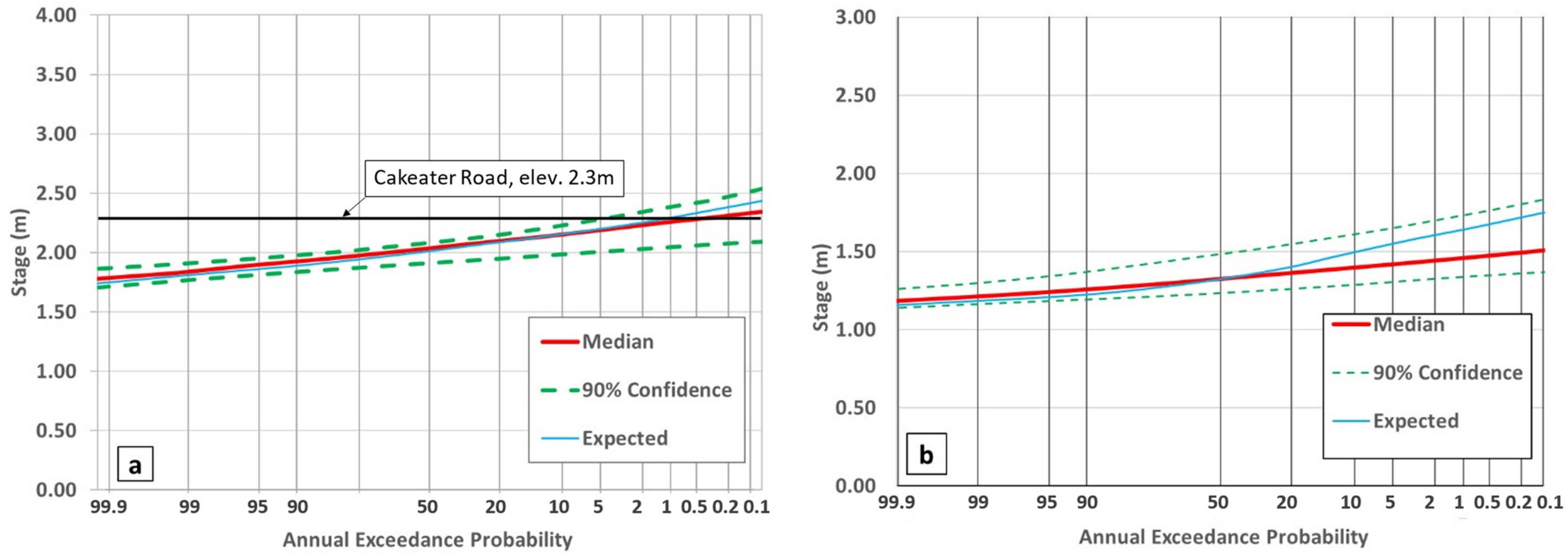
3.3. Stage Frequency and Uncertainty
4. Discussion
5. Conclusions
Author Contributions
Funding
Data Availability Statement
Acknowledgments
Conflicts of Interest
References
- Schramm, I.; Boike, J.; Bolton, W.R.; Hinzman, L.D. Application of TopoFlow, a spatially distributed hydrological model, to the Imnavait Creek watershed. Alaska. J. Geophys. Res. Biogeosci. 2007, 112, G4. [Google Scholar] [CrossRef]
- Pohl, S.; Davison, B.; Marsh, P.; Pietroniro, A. Modelling spatially distributed snowmelt and meltwater runoff in a small Arctic catchment with a hydrology land-surface scheme (WATCLASS). Atmosphere-Ocean 2005, 43, 193–211. [Google Scholar] [CrossRef]
- Kane, D.L.; Hinzman, L.D.; Benson, C.S.; Liston, G.E. Snow hydrology of a headwater Arctic basin: 1. Physical measurements and process studies. Water Resour. Res. 1991, 27, 1099–1109. [Google Scholar] [CrossRef]
- Hinzman, L.D.; Kane, D.L. Snow hydrology of a headwater Arctic basin: 2. Conceptual analysis and computer modeling. Water Resour. Res. 1991, 27, 1111–1121. [Google Scholar] [CrossRef]
- Soulis, E.D.; Snelgrove, K.R.; Kouwen, N.; Seglenieks, F.; Verseghy, D.L. Towards Closing the Vertical Water Balance in Canadian Atmospheric Models: Coupling of the Land Surface Scheme CLASS with the Distributed Hydrological Model WATFLOOD. Atmosphere-Ocean 2000, 38, 251–269. [Google Scholar] [CrossRef]
- Bui, M.T.; Lu, J.; Nie, L. A Review of Hydrological Models Applied in the Permafrost-Dominated Arctic Region. Geosciences 2020, 10, 401. [Google Scholar] [CrossRef]
- Xia, Z.; Woo, M. Theoretical analysis of snow-dam decay. J. Glaciol. 1992, 38, 191–199. [Google Scholar] [CrossRef]
- Liston, G.E.; Elder, K. A distributed snow-evolution modeling system (SnowModel). J. Hydrometeorol. 2006, 7, 1259–1276. [Google Scholar] [CrossRef]
- Liston, G.E.; Mernild, S.H. Greenland Freshwater Runoff. Part I: A Runoff Routing Model for Glaciated and Nonglaciated Landscapes (HydroFlow). J. Clim. 2012, 25, 5997–6014. [Google Scholar] [CrossRef]
- McCarthy, K.A. Overview of Environmental and Hydrogeologic Conditions at Barrow, Alaska; US Department of the Interior, US Geological Survey: Washington, DC, USA, 1994. [Google Scholar]
- Braddock, J.F.; McCarthy, K.A. Hydrologic and microbiological factors affecting persistence and migration of petroleum hydrocarbons spilled in a continuous-permafrost region. Environ. Sci. Technol. 1996, 30, 2626–2633. [Google Scholar] [CrossRef]
- Dingman, S.L.; Barry, R.G.; Weller, G.; Benson, C.S.; LeDrew, E.F.; Goodwin, C.W. Climate, Snow Cover, Microclimate, and Hydrology. In An Arctic Ecosystem: The Coastal Tundra at Barrow, Alaska; Brown, J., Miller, P.C., Tieszen, L.L., Bunnell, F.L., Eds.; U.S./IBP Synthesis Series 12; Dowden, Hutchinson & Ross, Inc.: Stroudsburg, PA, USA, 1980; pp. 30–78. Available online: https://www.arlis.org/docs/vol1/B/5564803.pdf (accessed on 1 May 2024).
- Liljedahl, A.K.; Hinzman, L.D.; Kane, D.L.; Oechel, W.C.; Tweedie, C.E.; Zona, D. Tundra water budget and implications of precipitation underestimation. Water Resour. Res. 2017, 53, 6472–6486. [Google Scholar] [CrossRef]
- Brown, J.; Dingman, S.L.; Lewellen, R.I. Hydrology of a Drainage Basin on the Alaskan Coastal Plain; Research Report 240; Cold Regions Research and Engineering Laboratory: Hanover, NH, USA, 1968. [Google Scholar]
- Douglas, T.A.; Sturm, M.; Blum, J.D.; Polashenski, C.; Stuefer, S.; Hiemstra, C.; Steffen, A.; Filhol, S.; Prevost, R. A Pulse of Mercury and Major Ions in Snowmelt Runoff from a Small Arctic Alaska Watershed. Environ. Sci. Technol. 2017, 51, 11145–11155. [Google Scholar] [CrossRef] [PubMed]
- Lund, J.; Forster, R.R.; Deeb, E.J.; Liston, G.E.; Skiles, S.M.; Marshall, H.P. Interpreting Sentinel-1 SAR backscatter signals of snowpack surface melt/freeze, warming, and ripening, through field measurements and physically-based SnowModel. Remote Sens. 2022, 14, 4002. [Google Scholar] [CrossRef]
- QSI Anchorage. North Slope Borough Communities, Alaska 3DEP LiDAR Technical Data Report, 2019. Available online: https://noaa-nos-coastal-lidar-pds.s3.amazonaws.com/laz/geoid12b/9197/supplemental/2019_North_Slope_Borough_Communities_3DEP_LiDAR_Technical_Data_Report.pdf (accessed on 6 January 2022).
- Hersbach, H.; Bell, B.; Berrisford, P.; Hirahara, S.; Horányi, A.; Muñoz-Sabater, J.; Nicolas, J.; Peubey, C.; Radu, R.; Schepers, D.; et al. The ERA5 global reanalysis. Q. J. R. Meteorol. Soc. 2020, 146, 1999–2049. [Google Scholar] [CrossRef]
- Muñoz Sabater, J. ERA5-Land Hourly Data from 1981 to Present. Copernicus Climate Change Service (C3S) Climate Data Store (CDS), 2019. Available online: https://cds.climate.copernicus.eu/cdsapp#!/dataset/reanalysis-era5-land?tab=overview (accessed on 14 March 2022).
- McCrystall, M.R.; Stroeve, J.; Serreze, M.; Forbes, B.C.; Screen, J.A. New climate models reveal faster and larger increases in Arctic precipitation than previously projected. Nat. Commun. 2021, 12, 6765. [Google Scholar] [CrossRef]
- Sturm, M. 2007–2013. “Barrow Field Studies Data Collection [Data Set Series]”. Arctic Data CenterFor Specific Datasets, Search by Principal Investigator “Matthew Sturm” and Collection Year. Example Dataset: “Barrow_field_200712”. Available online: https://arcticdata.io/catalog/ (accessed on 12 March 2024).
- Hall, D.K.; Riggs, G.A. MODIS/Terra Snow Cover Daily L3 Global 500 m SIN Grid, Version 61 [Data Set]; NASA National Snow and Ice Data Center Distributed Active Archive Center: Boulder, CO, USA, 2021. [Google Scholar] [CrossRef]
- Milliman, T.; Seyednasrollah, B.; Young, A.M.; Hufkens, K.; Friedl, M.A.; Frolking, S.; Richardson, A.D.; Abraha, M.; Allen, D.W.; Apple, M.; et al. PhenoCam Dataset v2.0: Digital Camera Imagery from the PhenoCam Network, 2000–2018. ORNL–Distributed Active Archive Center: Oak Ridge, TN, 2019. Available online: https://daac.ornl.gov/cgi-bin/dsviewer.pl?ds_id=1689 (accessed on 11 January 2022).
- Seyednasrollah, B.; Young, A.M.; Hufkens, K.; Milliman, T.; Friedl, M.A.; Frolking, S.; Richardson, A.D. Tracking Vegetation Phenology Across Diverse Biomes using Version 2.0 of the PhenoCam Dataset. Sci. Data 2019, 6, 222. [Google Scholar] [CrossRef] [PubMed]
- U.S. Army Corps of Engineers Hydrologic Engineering Center, n.d. HEC-RAS (Version 5.0.7) [Software]. Available online: https://www.hec.usace.army.mil/software/hec-ras/ (accessed on 11 January 2022).
- Stuefer, S.L.; Arp, C.D.; Kane, D.L.; Liljedahl, A.K. Recent Extreme Runoff Observations from Coastal Arctic Watersheds in Alaska. Water Resour. Res. 2017, 53, 9145–9163. [Google Scholar] [CrossRef]
- Dewitz, J. National Land Cover Database (NLCD) 2016 Products; US Geological Survey: Washington, DC, USA, 2019. [Google Scholar]
- USACE. Creating Land Cover, Manning’s n Value, and % Impervious Layers. Available online: https://www.hec.usace.army.mil/confluence/rasdocs/r2dum/latest/developing-a-terrain-model-and-geospatial-layers/creating-land-cover-mannings-n-values-and-impervious-layers (accessed on 8 December 2022).
- Dilley, L. Draft Geotechnical Report. Barrow Roads: Laura Madison Road and Uivaqsaagiaq Road; Hattenburg Dilley and Linell: Anchorage, AK, USA, 2008. [Google Scholar]
- Coleman, S. Itasigrook Dam (AK00053) Barrow, Alaska Periodic Safety Inspection Report Draft; WHPacific: Anchorage, AK, USA, 2016. [Google Scholar]
- England, J.F., Jr.; Cohn, T.A.; Faber, B.A.; Stedinger, J.R.; Thomas, W.O., Jr.; Veilleux, A.G.; Kiang, J.E.; Mason, R.R., Jr. Guidelines for Determining Flood Flow Frequency—Bulletin 17C; US Geological Survey: Washington, DC, USA, 2019; No. 4-B5. [Google Scholar]
- U.S. Army Corps of Engineers Hydrologic Engineering Center, n.d. HEC-SSP (Version 2.3) [Software]. Available online: https://www.hec.usace.army.mil/software/hec-ssp/ (accessed on 18 September 2022).
- USACE (US Army Corps of Engineers). Engineering and Design: Risk-Based Analysis for Flood Damage Reduction Studies. Manual No. 1110-2-1619; US Department of the Army, US Army Corps of Engineers: Washington, DC, USA, 1996; Available online: https://www.publications.usace.army.mil/Portals/76/Publications/EngineerManuals/EM_1110-2-1619.pdf (accessed on 19 September 2022).
- HEC (Hydrologic Engineering Center). HEC-Flood Damage Reduction Analysis: User’s Manual. CPD-72 (Version 1.4.1); US Army Corps of Engineers, Hydrologic Engineering Center: Davis, CA, USA, 2016; Available online: https://www.hec.usace.army.mil/software/hec-fda/documentation/CPD-72_V1.4.1.pdf (accessed on 18 September 2022).
- Wagner, A.M.; Engel, C.; Ho, D.; Giovando, J.; Morriss, B.; Deeb, E. Stage Frequency Analysis from Snowmelt Runoff near Utqiaġvik, Alaska. ERDC/CRREL TR-23-16; US Army Corps of Engineers, Engineer Research and Development Center: Washington, DC, USA, 2023. [Google Scholar]


| NLCD Classification | Manning’s Roughness Value |
|---|---|
| NoData | 0.04 |
| Sedge-Herbaceous | 0.04 |
| Open Water | 0.035 |
| Emergent Herbaceous Wetlands | 0.06 |
| Developed, Open Space | 0.035 |
| Developed, Low Intensity | 0.08 |
| Developed, Medium Intensity | 0.12 |
| Distribution | K-S | Chi-Square | A-D |
|---|---|---|---|
| Generalized Pareto | 0.149 | 12.636 | 0.932 |
| LP3 | 0.153 | 11.909 | 0.953 |
| Triangular | 0.158 | 13.000 | 1.055 |
| Ln-Normal | 0.161 | 10.818 | 0.995 |
| Log10-Normal | 0.161 | 10.818 | 0.995 |
| Shifted Exponential | 0.170 | 9.727 | 1.315 |
| Gamma | 0.177 | 12.636 | 1.087 |
| Log-Logistic | 0.181 | 10.818 | 1.424 |
| Uniform | 0.186 | 28.636 | 0.988 |
| Gumbel | 0.197 | 12.273 | 1.352 |
| Pearson III | 0.197 | 14.818 | 1.332 |
| Shifted Gamma | 0.197 | 14.818 | 1.332 |
| Generalized Extreme Value | 0.200 | 19.182 | 1.365 |
| Normal | 0.232 | 27.909 | 1.759 |
| Exponential | 0.246 | 15.909 | 2.092 |
| Logistic | 0.252 | 17.727 | 2.109 |
| Year | KGE | Pearson-R | p-Bias |
|---|---|---|---|
| 1982 | −0.20 | 0.20 | −58.39 |
| 1983 | −3.31 | 0.04 | −241.33 |
| 1984 | −0.57 | 0.16 | −111.81 |
| 1985 | −0.67 | 0.00 | −63.43 |
| 1986 | −0.86 | 0.46 | −113.52 |
| 1987 | −0.12 | 0.01 | −14.16 |
| 1988 | −0.09 | 0.10 | 43.12 |
| 1989 | 0.44 | 0.47 | −15.58 |
| 1990 | −0.05 | 0.17 | −57.99 |
| 1991 | −0.25 | −0.22 | −26.52 |
| 1992 | −2.44 | 0.12 | −276.82 |
| 1993 | −0.19 | 0.07 | −73.41 |
| 1994 | 0.48 | 0.60 | −32.83 |
| 1995 | 0.14 | 0.38 | −57.43 |
| 1996 | −0.64 | 0.06 | −131.85 |
| 1997 | −0.55 | 0.39 | −106.55 |
| 1998 | −0.74 | 0.02 | −60.18 |
| 1999 | 0.06 | 0.17 | 27.38 |
| 2000 | 0.45 | 0.47 | −7.09 |
| 2001 | 0.84 | 0.85 | 2.22 |
| 2002 | −0.23 | 0.36 | −70.74 |
| 2003 | −2.03 | 0.39 | −171.63 |
| 2004 | 0.73 | 0.79 | −1.78 |
| Middle Salt Lagoon (MCM) | Tasigarook Lagoon (MCM) | |
|---|---|---|
| Minimum | 1.36 | 0.76 |
| Maximum | 3.05 | 1.91 |
| Mean | 2.13 | 1.26 |
| Standard Deviation | 0.49 | 0.32 |
Disclaimer/Publisher’s Note: The statements, opinions and data contained in all publications are solely those of the individual author(s) and contributor(s) and not of MDPI and/or the editor(s). MDPI and/or the editor(s) disclaim responsibility for any injury to people or property resulting from any ideas, methods, instructions or products referred to in the content. |
© 2024 by the authors. Licensee MDPI, Basel, Switzerland. This article is an open access article distributed under the terms and conditions of the Creative Commons Attribution (CC BY) license (https://creativecommons.org/licenses/by/4.0/).
Share and Cite
Engel, C.; Wagner, A.; Giovando, J.; Ho, D.; Morriss, B.; Deeb, E. Estimating Stage-Frequency Curves for Engineering Design in Small Ungauged Arctic Watersheds. Water 2024, 16, 1321. https://doi.org/10.3390/w16101321
Engel C, Wagner A, Giovando J, Ho D, Morriss B, Deeb E. Estimating Stage-Frequency Curves for Engineering Design in Small Ungauged Arctic Watersheds. Water. 2024; 16(10):1321. https://doi.org/10.3390/w16101321
Chicago/Turabian StyleEngel, Chandler, Anna Wagner, Jeremy Giovando, David Ho, Blaine Morriss, and Elias Deeb. 2024. "Estimating Stage-Frequency Curves for Engineering Design in Small Ungauged Arctic Watersheds" Water 16, no. 10: 1321. https://doi.org/10.3390/w16101321
APA StyleEngel, C., Wagner, A., Giovando, J., Ho, D., Morriss, B., & Deeb, E. (2024). Estimating Stage-Frequency Curves for Engineering Design in Small Ungauged Arctic Watersheds. Water, 16(10), 1321. https://doi.org/10.3390/w16101321