
A Framework for Assessment of Flood Conditions Using Hydrological and Hydrodynamic Modeling Approach
Abstract
:1. Introduction
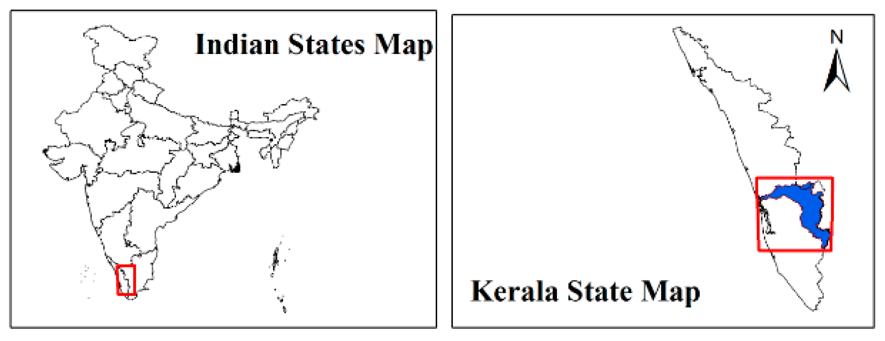
2. Study Area
3. Hydrological and Hydrodynamic Models
3.1. SWAT Model
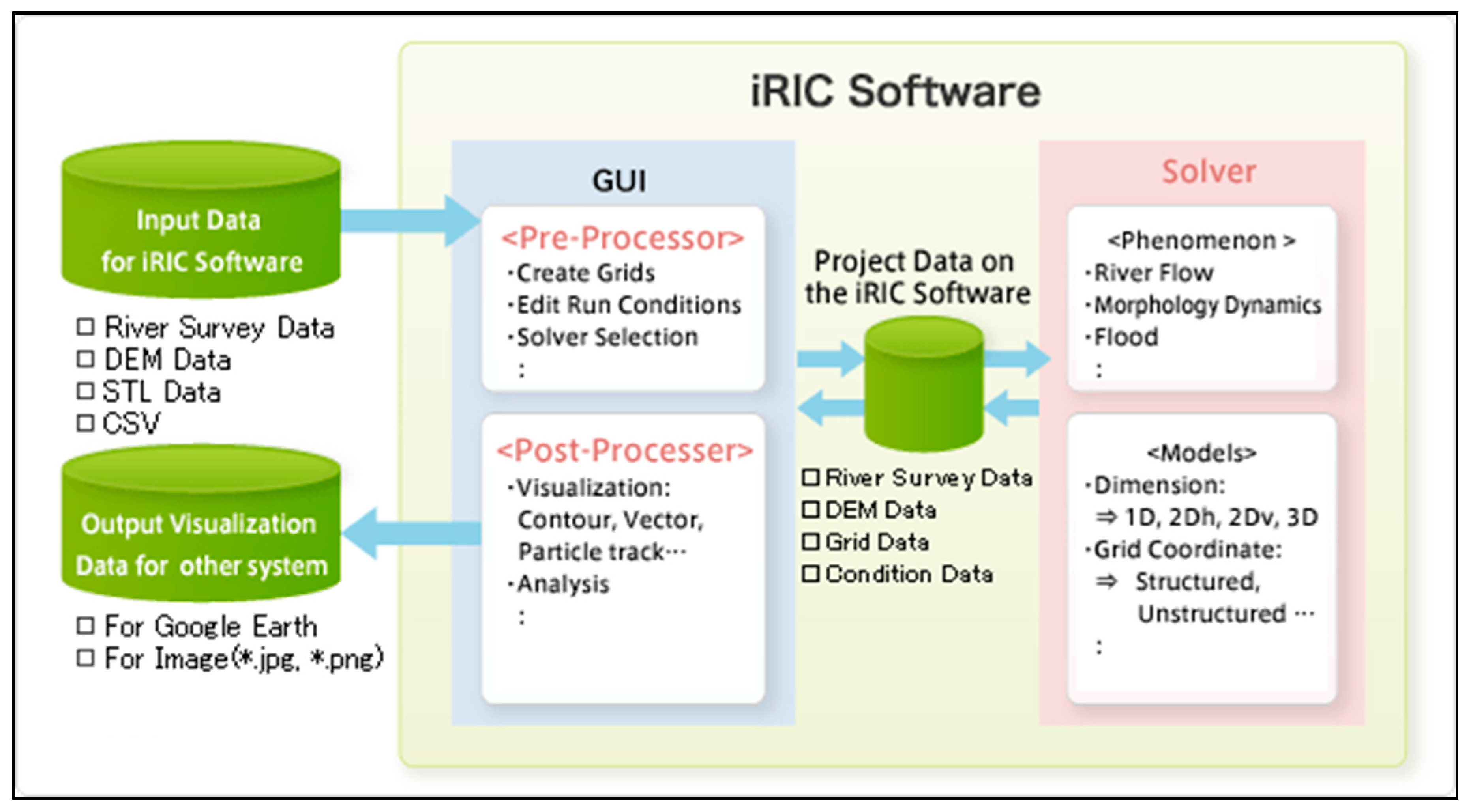
3.2. iRIC Model
4. Model Efficiency
4.1. Nash Sutcliffe Efficiency Index
4.2. Percent Bias
5. Results and Discussion
5.1. Hydrological Modelling—SWAT
5.1.1. Model Development
5.1.2. Calibration and Validation of the Model
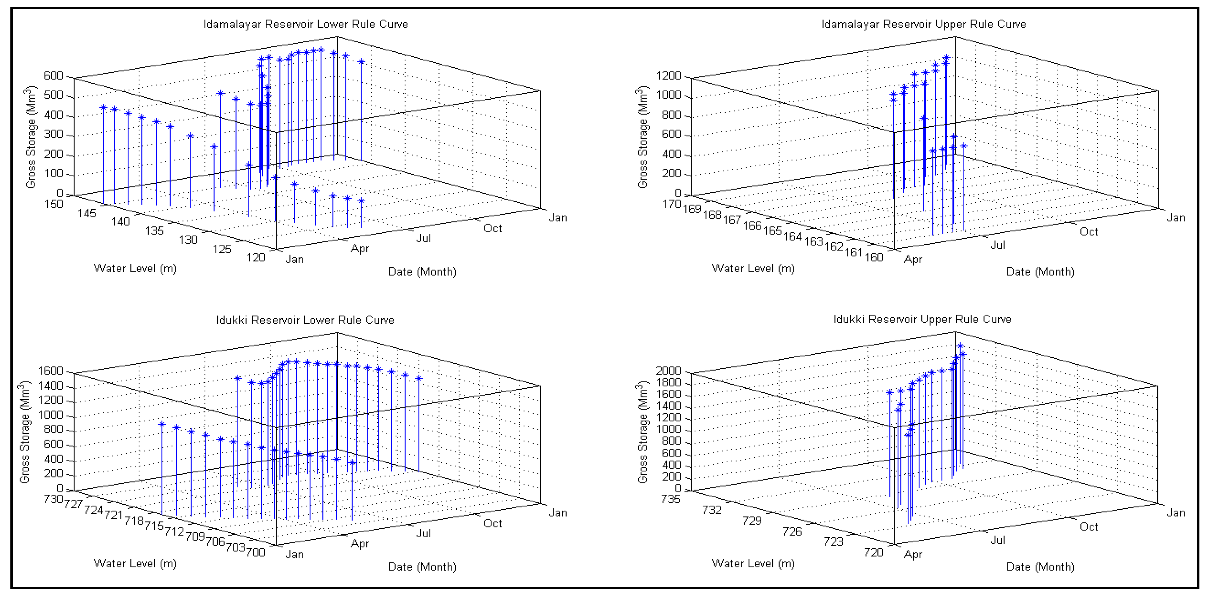
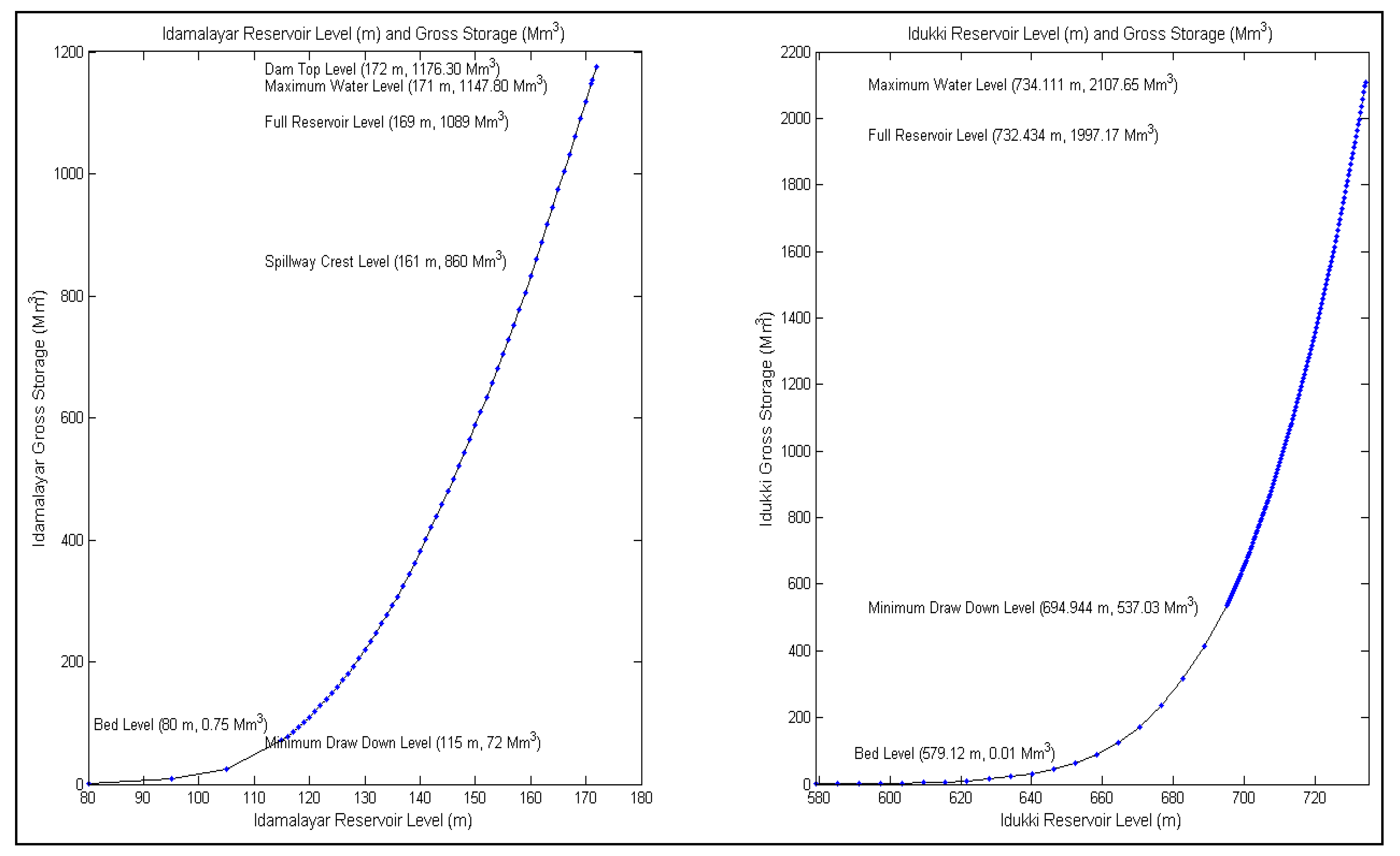
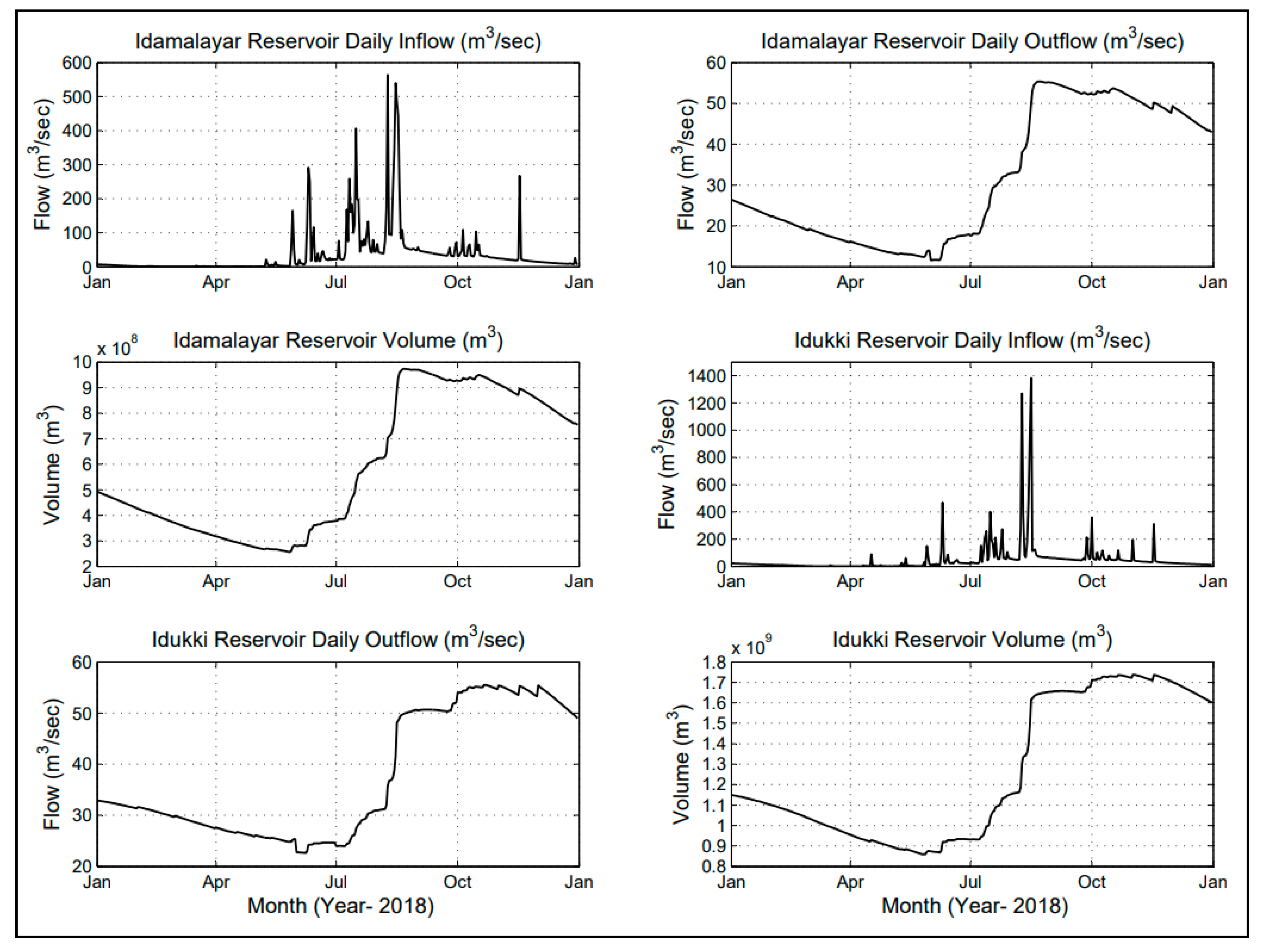
5.2. Reservoir (Idukki and Idamalyar) Rule Curve
5.2.1. Idamalayar Reservoir
5.2.2. Idukki Reservoir
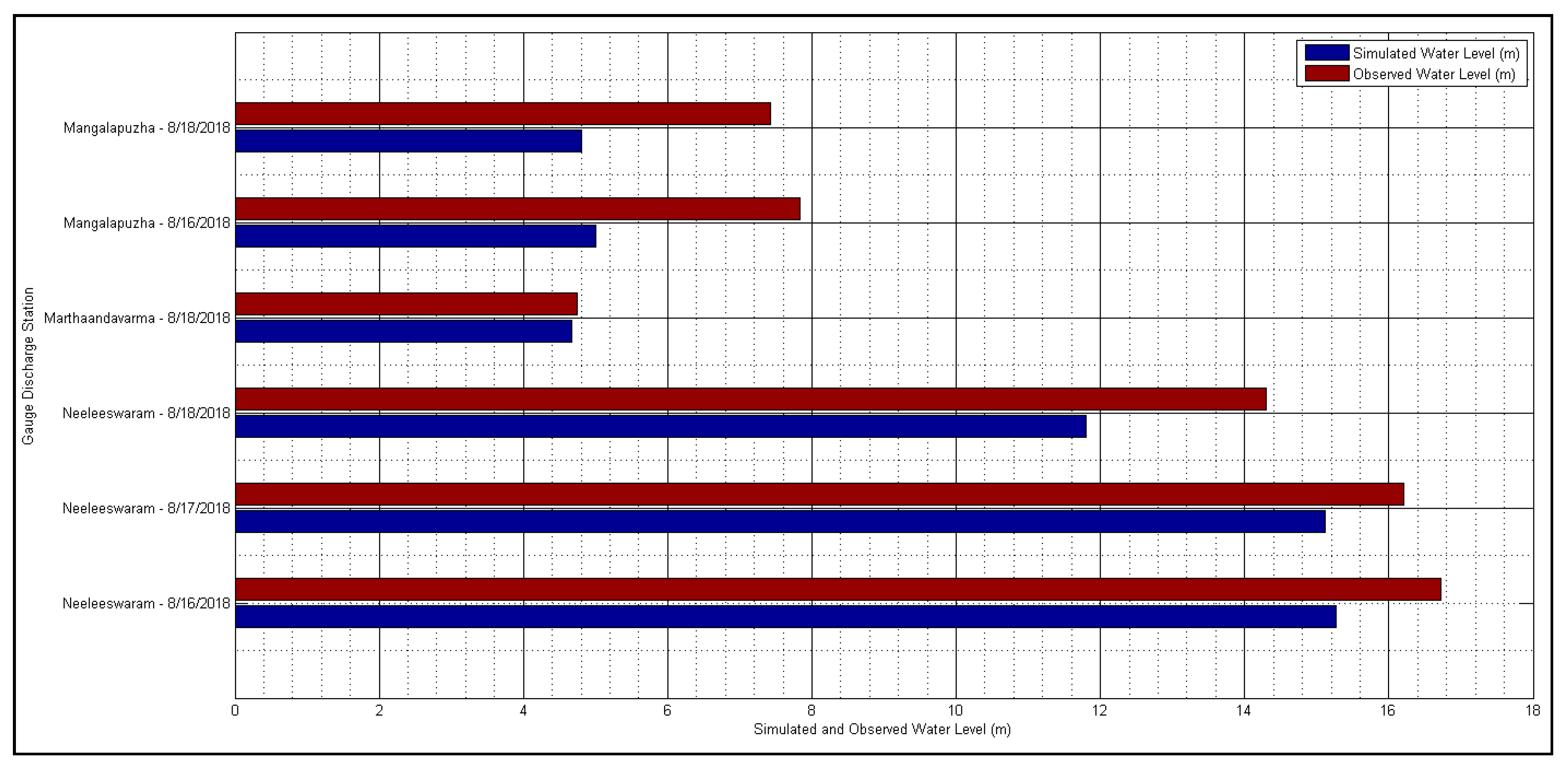
5.3. Calibration and Validation of iRIC Model
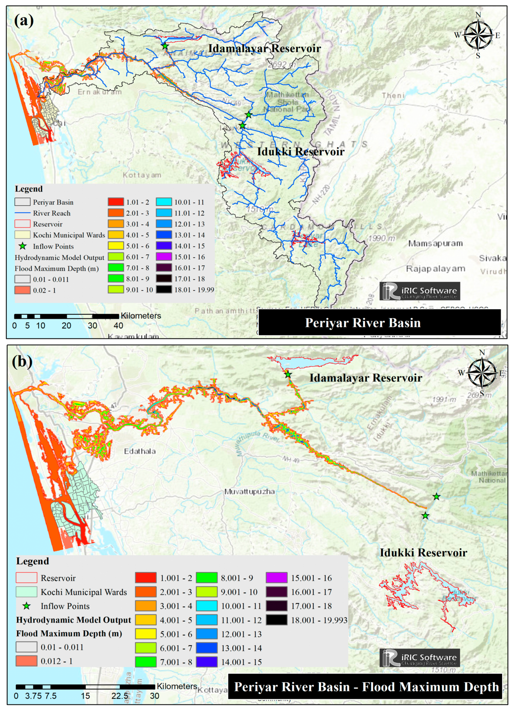
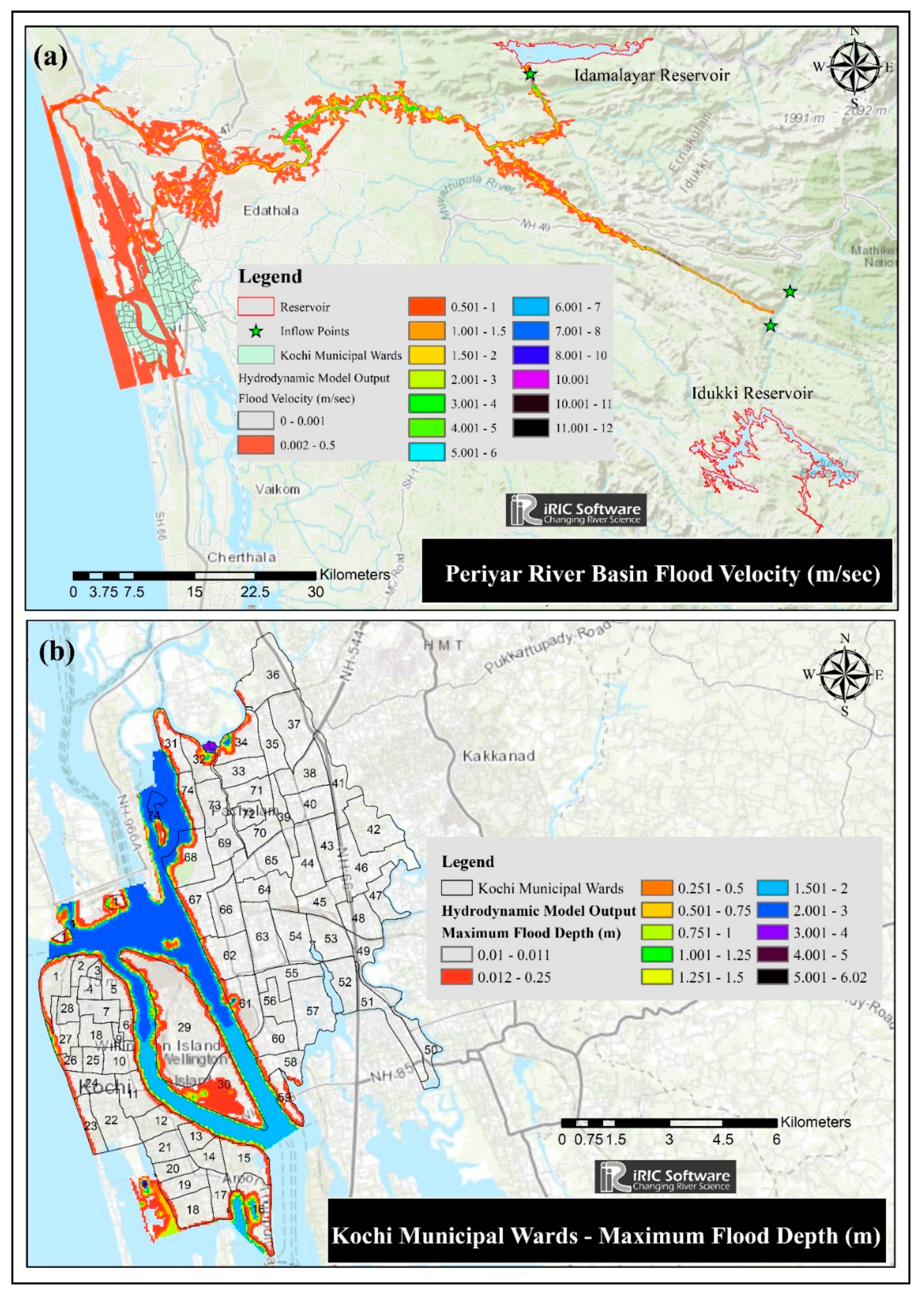
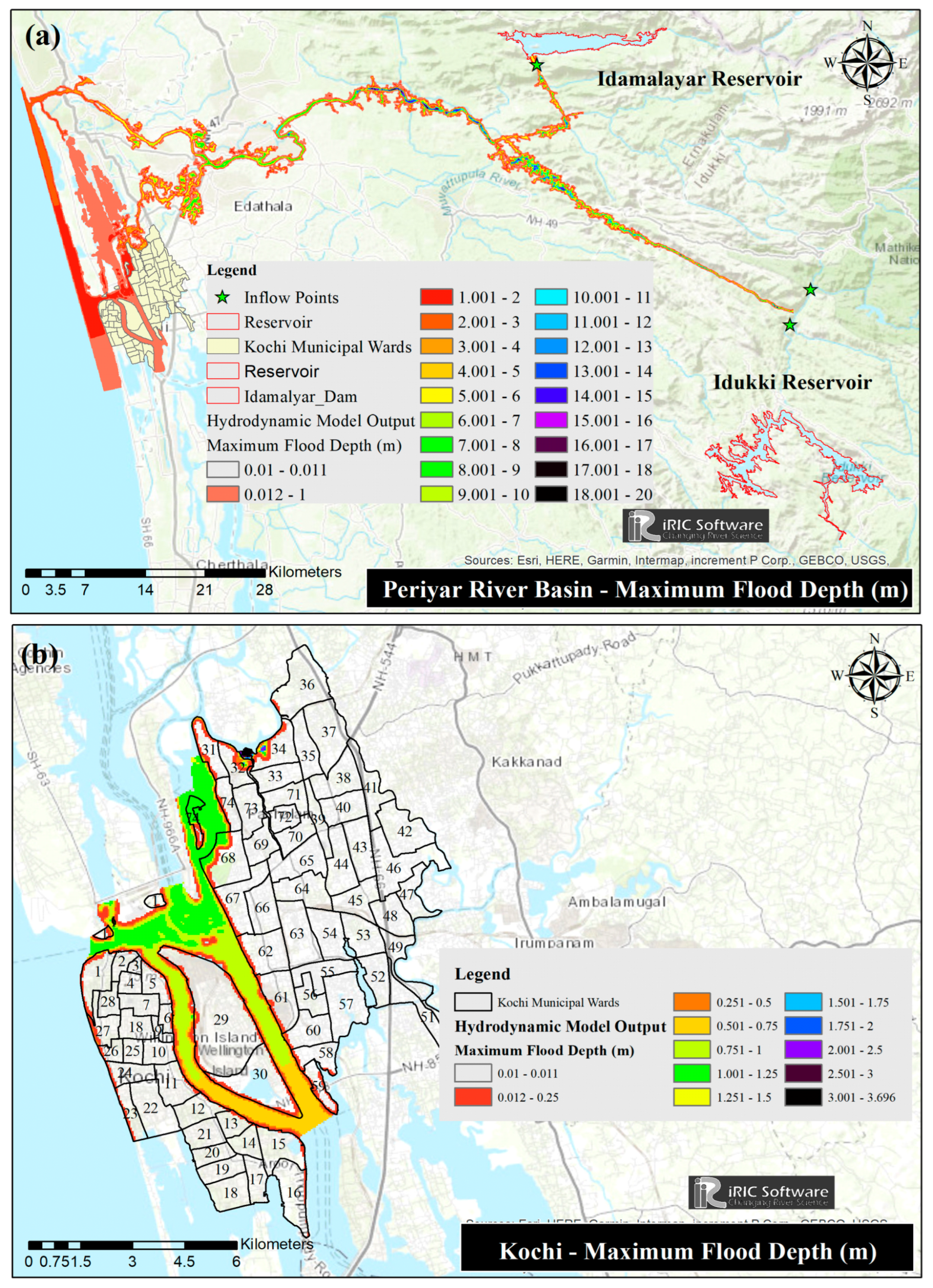
5.4. Coupled Hydrological and Hydrodynamic Model
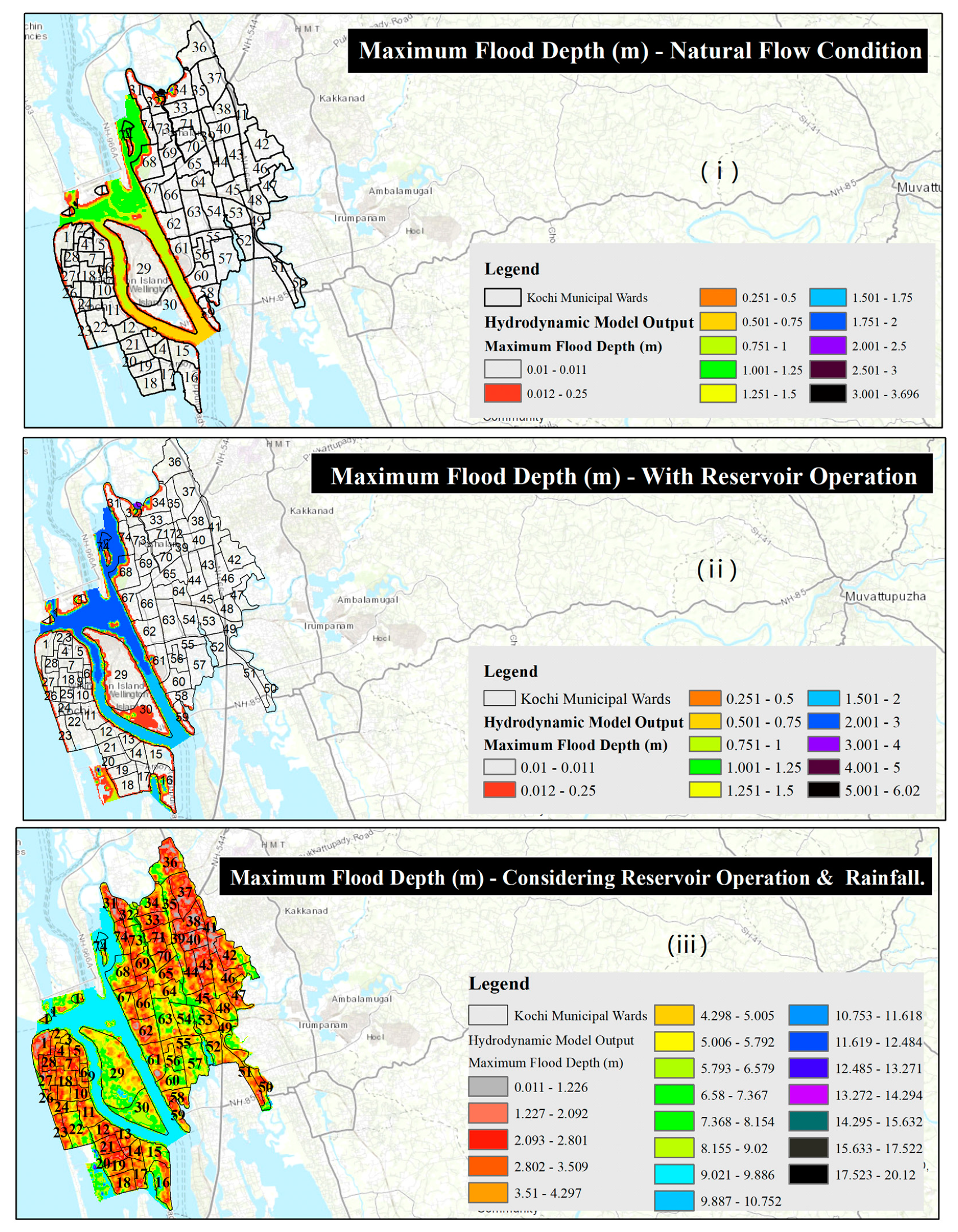
5.4.1. Scenario 1: Considering Reservoir Existing Rule Curve and Release from Reservoir
5.4.2. Scenario 2: Considering Natural Flow Conditions without Reservoir
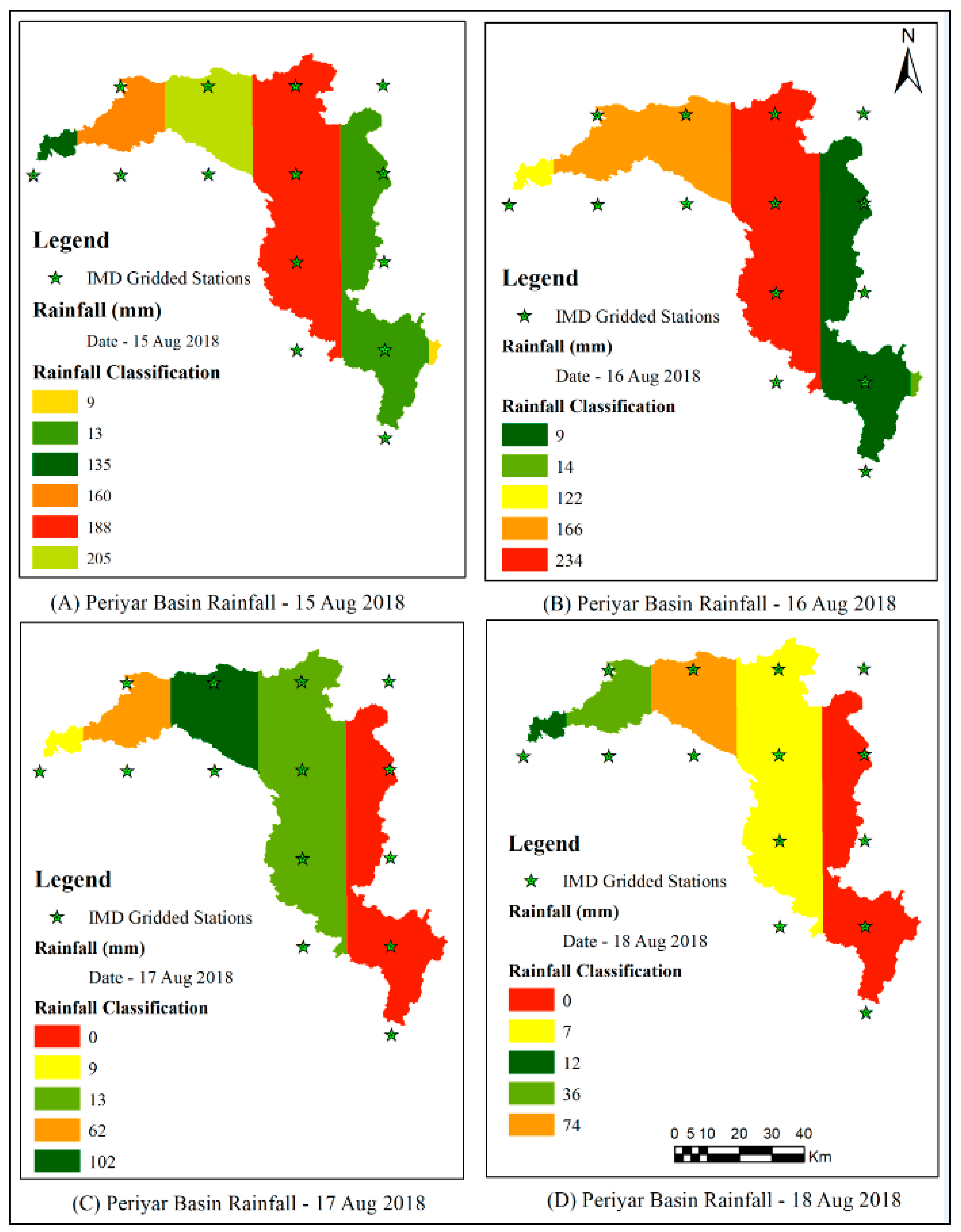
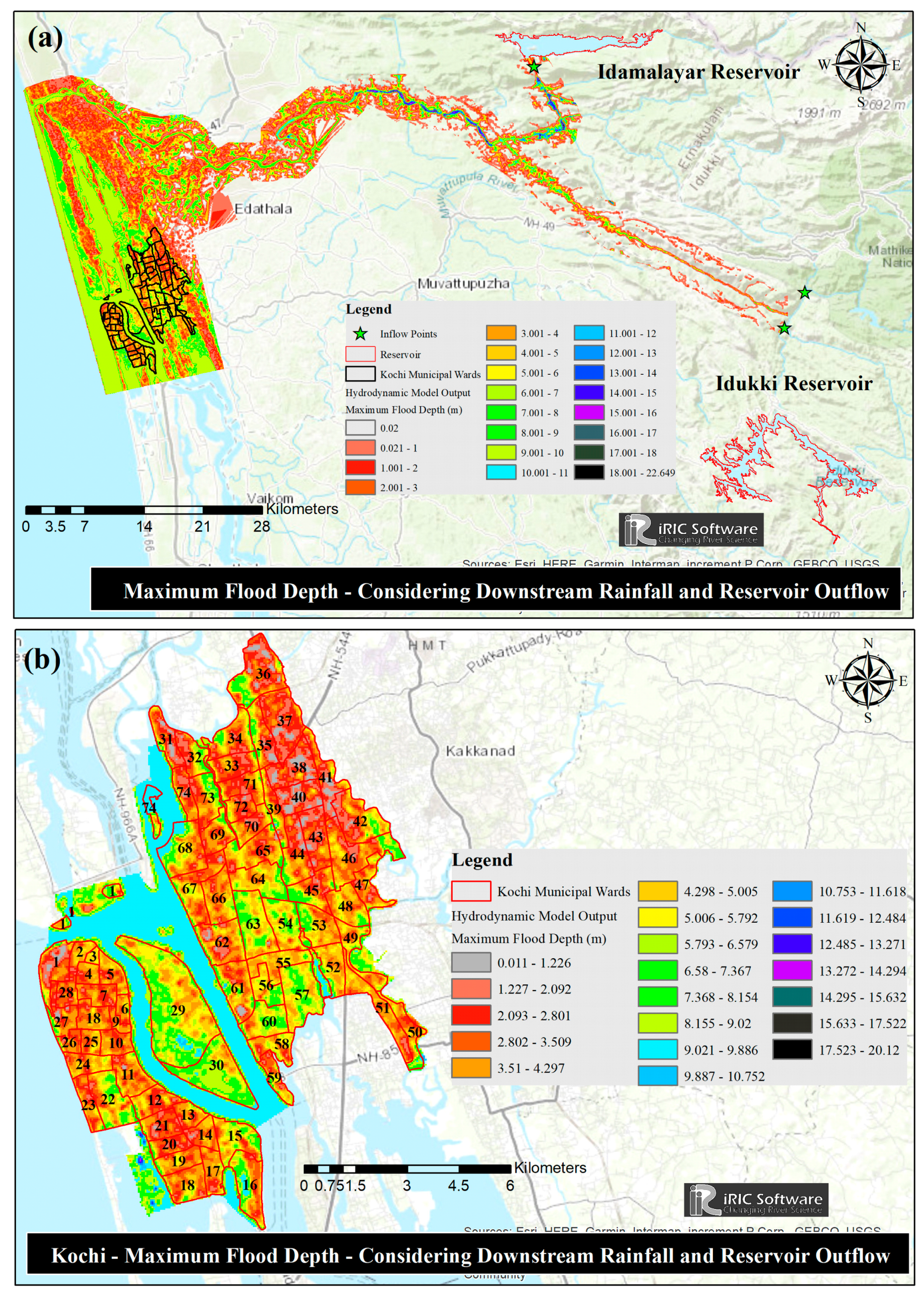
5.4.3. Scenario 3: Considering Reservoir Rule Curve and Downstream Rainfall
6. Conclusions
Author Contributions
Funding
Data Availability Statement
Conflicts of Interest
References
- Brakenridge, G.; Anderson, E.; Caquard, S. Dartmouth Flood Observatory. From Dartmouth Flood Observatory. 2005. Available online: http://www.dartmouth.edu/~floods/ (accessed on 24 April 2007).
- Brakenridge, G.R.; Anderson, E.K.; Carlos, H. Dartmouth Active Archive of Major Floods. 2009. Available online: http://www.dartmouth.edu/~floods/Archives/index.html (accessed on 10 March 2014).
- EM-DAT. The OFDA/CRED International Disaster Database, Version 12.07; Univ. Catholique de Louvain: Brussels, Belgium, 2014; Available online: www.emdat.be (accessed on 26 March 2022).
- Di Baldassarre, G.; Montanari, A.; Lins, H.; Koutsoyiannis, D.; Brandimarte, L.; Blöschl, G. Flood fatalities in Africa: From diagnosis to mitigation. Geophys. Res. Lett. 2010, 37, L22402. [Google Scholar] [CrossRef] [Green Version]
- Hirsch, R.M.; Ryberg, K.R. Has the magnitude of floods across the USA changed with global CO2 levels? Hydrol. Sci. J. 2012, 57, 1–9. [Google Scholar] [CrossRef]
- Kundzewicz, Z.W.; Kanae, S.; Seneviratne, S.I.; Handmer, J.; Nicholls, N.; Peduzzi, P.; Mechler, R.; Bouwer, L.M.; Arnell, N.; Mach, K.; et al. Flood risk and global and regional climate change prospects. Hydrol. Sci. J. 2014, 59, 1–28. [Google Scholar] [CrossRef] [Green Version]
- Sewa International. Diaspora, Disaster and Development; Sewa International: New Delhi, India, 2023. [Google Scholar]
- National Disaster Management Authority (NDMA), New Delhi. Available online: http://www.ndma.gov.in (accessed on 5 April 2022).
- Central Water Commission State-Wide Flood Data Damage Statistics. 2018. Available online: http://cwc.gov.in/sites/default/files/statewiseflooddatadamagestatistics.pdf.33 (accessed on 9 April 2022).
- Werner, M. Spatial Flood Extent Modeling—A Performance-Based Comparison. Ph.D. Thesis, Delft University, Delft, The Netherlands, 2004. [Google Scholar]
- Bates, P.D.; Lane, S.N.; Ferguson, R.I. (Eds.) Computational Fluid Dynamics: Applications in Environmental Hydraulics; John Wiley & Sons: Hoboken, NJ, USA, 2005. [Google Scholar]
- Rai, P.K.; Dhanya, C.T.; Chahar, B.R. Coupling of 1D models (SWAT and SWMM) with 2D model (iRIC) for mapping inundation in Brahmani and Baitarani river delta. Nat. Hazards 2018, 92, 1821–1840. [Google Scholar] [CrossRef]
- Kumar, S.; Agarwal, A.; Villuri, V.G.K.; Pasupuleti, S.; Kumar, D.; Kaushal, D.R.; Gosain, A.K.; Bronstert, A.; Sivakumar, B. Constructed wetland management in urban catchments for mitigating floods. Stoch. Environ. Res. Risk Assess. 2021, 35, 2105–2124. [Google Scholar] [CrossRef]
- Di Luzio, M.; Arnold, J.G.; Srinivasan, R. Effect of GIS data quality on small watershed stream flow and sediment simulations. Hydrol. Process. Int. J. 2005, 19, 629–650. [Google Scholar] [CrossRef]
- Srinivasan, R.; Arnold, J.G. Integration of a Basin-Scale Water Quality Model with GIS. J. Am. Water Resour. Assoc. 1994, 30, 453–462. [Google Scholar] [CrossRef]
- Bian, L.; Sun, H.; Blodgett, C.; Egbert, S.; Li, W.; Ran, L.; Koussis, A. An integrated interface system to couple the SWAT model and ARC/INFO. In Proceedings of the 3rd International Conference on Integrating GIS and Environmental Modeling, CD-ROM, US National Center for Geographic Information and Analysis, Santa Fe, NM, USA, 21–25 January 1996. [Google Scholar]
- Di Luzio, M.; Srinivasan, R.; Arnold, J.G. An integrated user interface for SWAT using ArcView and Avenue. Trans. Am. Soc. Agric. Eng. 1997, 2, 16. [Google Scholar]
- Arnold, J.G.; Srinivasan, R.; Muttiah, R.S.; Williams, J.R. Large area hydrologic modeling and assessment part I: Model development 1. JAWRA J. Am. Water Resour. Assoc. 1998, 34, 73–89. [Google Scholar] [CrossRef]
- Neitsch, S.L. Soil and Water Assessment Tool; User’s Manual Version 2005; Texas Water Resources Institute: College Station, TX, USA, 2005; p. 476.
- Green, W.H.; Ampt, G.A. Studies on Soil Phyics. J. Agric. Sci. 1911, 4, 1–24. [Google Scholar] [CrossRef] [Green Version]
- Boughton, W.C. A review of the USDA SCS curve number method. Soil Res. 1989, 27, 511–523. [Google Scholar] [CrossRef]
- Williams, P.J.L. Evidence for the seasonal accumulation of carbon-rich dissolved organic material, its scale in comparison with changes in particulate material and the consequential effect on net CN assimilation ratios. Mar. Chem. 1995, 51, 17–29. [Google Scholar] [CrossRef]
- Monteith, J.L. Evaporation and environment. In Symposia of the Society for Experimental Biology; Cambridge University Press (CUP): Cambridge, UK, 1965; Volume 19, pp. 205–234. [Google Scholar]
- Hargreaves, G.H.; Samani, Z.A. Reference crop evapotranspiration from temperature. Appl. Eng. Agric. 1985, 1, 96–99. [Google Scholar] [CrossRef]
- Priestley, C.H.B.; Taylor, R.J. On the assessment of surface heat flux and evaporation using large-scale parameters. Mon. Weather Rev. 1972, 100, 81–92. [Google Scholar] [CrossRef]
- Arnold, D.S.; O’leary, S.G.; Wolff, L.S.; Acker, M.M. The Parenting Scale: A measure of dysfunctional parenting in discipline situations. Psychol. Assess. 1993, 5, 137. [Google Scholar] [CrossRef]
- Daniel, J. Sampling Essentials: Practical Guidelines for Making Sampling Choices; Sage Publications: Thousand Oaks, CA, USA, 2011. [Google Scholar]
- Borah, D.K.; Bera, M. Watershed-scale hydrologic and nonpoint-source pollution models: Review of mathematical bases. Trans. ASAE 2003, 46, 1553. [Google Scholar] [CrossRef] [Green Version]
- Jang, C.L.; Shimizu, Y. Numerical simulation of relatively wide, shallow channels with erodible banks. J. Hydraul. Eng. 2005, 131, 565–575. [Google Scholar] [CrossRef] [Green Version]
- Nelson, J.M.; Shimizu, Y.; Abe, T.; Asahi, K.; Gamou, M.; Inoue, T.; Iwasaki, T.; Kakinuma, T.; Kawamura, S.; Kimura, I.; et al. The international river interface cooperative: Public domain flow and morphodynamics software for education and applications. Adv. Water Resour. 2016, 93, 62–74. [Google Scholar] [CrossRef]
- Wongsa, S. Simulation of Thailand flood 2011. Int. J. Eng. Technol. 2014, 6, 452. [Google Scholar] [CrossRef] [Green Version]
- Moriasi, D.N.; Arnold, J.G.; Van Liew, M.W.; Bingner, R.L.; Harmel, R.D.; Veith, T.L. Model evaluation guidelines for systematic quantification of accuracy in watershed simulations. Trans. ASABE 2007, 50, 885–900. [Google Scholar] [CrossRef]
- Fadil, A.; Rhinane, H.; Kaoukaya, A.; Kharchaf, Y.; Bachir, O.A. Hydrologic modeling of the Bouregreg watershed (Morocco) using GIS and SWAT model. J. Geogr. Inf. Syst. 2011, 3, 279. [Google Scholar] [CrossRef] [Green Version]
- Nash, J.E.; Sutcliffe, J.V. River flow forecasting through conceptual models part I—A discussion of principles. J. Hydrol. 1970, 10, 282–290. [Google Scholar] [CrossRef]
- Gupta, H.V.; Sorooshian, S.; Yapo, P.O. Status of automatic calibration for hydrologic models: Comparison with multilevel expert calibration. J. Hydrol. Eng. 1999, 4, 135–143. [Google Scholar] [CrossRef]
- Arnold, J.G.; Fohrer, N. SWAT2000: Current capabilities and research opportunities in applied watershed modelling. Hydrol. Process. Int. J. 2005, 19, 563–572. [Google Scholar] [CrossRef]
- Chow, V.T. Open Channel Hydraulics; McGraw-Hill Book Company: New York, NY, USA, 1959. [Google Scholar]


| Sr. No. | Parameter | Process | Description | Unit | Range (Min–Max) | SWAT Default Value | Fitted Value |
|---|---|---|---|---|---|---|---|
| 1 | CN2.mgt | Surface runoff | SCS runoff curve number for moisture condition II | - | 30–98 | Changes for HRU | 50–80 (Varies by HRU) |
| 2 | ALPHA_BF.gw | Groundwater | Baseflow alpha factor (d−1) | - | 0–1 | 0.048 | 0.036 |
| 3 | GWQMN.gw | Groundwater | Threshold depth of water in the shallow aquifer required for return flow to occur | mm H2O | 0–5000 | 0 | 1150 |
| 4 | GW_REVAP.gw | Groundwater | Groundwater ‘revap’ coefficient | - | 0–500 | 1 | 0.09 |
| 5 | CH_N2.rte | Surface runoff (Channel) | Manning’s ‘n’ value for main Channel | - | −0.01–0.3 | 0.014 | 0.017 |
| 6 | ESCO. Hru | Surface runoff (HRU) | Soil Evaporation Compensation Factor | - | 0–1 | 0.95 | 0.78 |
| 7 | GW DELAY.gw | Groundwater | Ground Water Delay Time | days | 0–500 | 31 | 38 |
| 8 | SOL AWC. Sol | Surface runoff | Available Water Capacity | mm H2O/mm soil | 0–1 | - | 0.26 |
| 9 | EPCO.bsn | Surface runoff (hru) | Plant uptake compensation factor | - | 0–1 | 0 | 0.11 |
| 10 | RES_K.res | Reservoir | Hydraulic conductivity of reservoir bottom | Mm/h | 0.1–11.4 | - | 2.1 |
| 11 | SURLAG. Bsn | Surface runoff | Surface runoff lag time | days | 1–24 | 4 | 4.19 |
| 12 | SHALLST.gw | Groundwater | Initial depth of water in the shallow aquifer | mm H2O | 0–1000 | 0.5 | 0.65 |
| Station Name | Daily Calibration | Daily Validation | Monthly Calibration | Monthly Validation | ||||
|---|---|---|---|---|---|---|---|---|
| NSE | PBIAS | NSE | PBIAS | NSE | PBIAS | NSE | PBIAS | |
| Neeleeshwaram | 0.588 | 17.07 | 0.514 | 19.354 | 0.767 | 21.103 | 0.632 | 23.175 |
| Kalady | 0.538 | 21.023 | 0.619 | 20.656 | 0.642 | 24.638 | 0.752 | 12.771 |
Disclaimer/Publisher’s Note: The statements, opinions and data contained in all publications are solely those of the individual author(s) and contributor(s) and not of MDPI and/or the editor(s). MDPI and/or the editor(s) disclaim responsibility for any injury to people or property resulting from any ideas, methods, instructions or products referred to in the content. |
© 2023 by the authors. Licensee MDPI, Basel, Switzerland. This article is an open access article distributed under the terms and conditions of the Creative Commons Attribution (CC BY) license (https://creativecommons.org/licenses/by/4.0/).
Share and Cite
Kumar, A.; Khosa, R.; Gosian, A.K. A Framework for Assessment of Flood Conditions Using Hydrological and Hydrodynamic Modeling Approach. Water 2023, 15, 1371. https://doi.org/10.3390/w15071371
Kumar A, Khosa R, Gosian AK. A Framework for Assessment of Flood Conditions Using Hydrological and Hydrodynamic Modeling Approach. Water. 2023; 15(7):1371. https://doi.org/10.3390/w15071371
Chicago/Turabian StyleKumar, Anil, Rakesh Khosa, and Ashwin Kumar Gosian. 2023. "A Framework for Assessment of Flood Conditions Using Hydrological and Hydrodynamic Modeling Approach" Water 15, no. 7: 1371. https://doi.org/10.3390/w15071371