
Analysis of Runoff According to Land-Use Change in the Upper Hutuo River Basin


Abstract
:1. Introduction
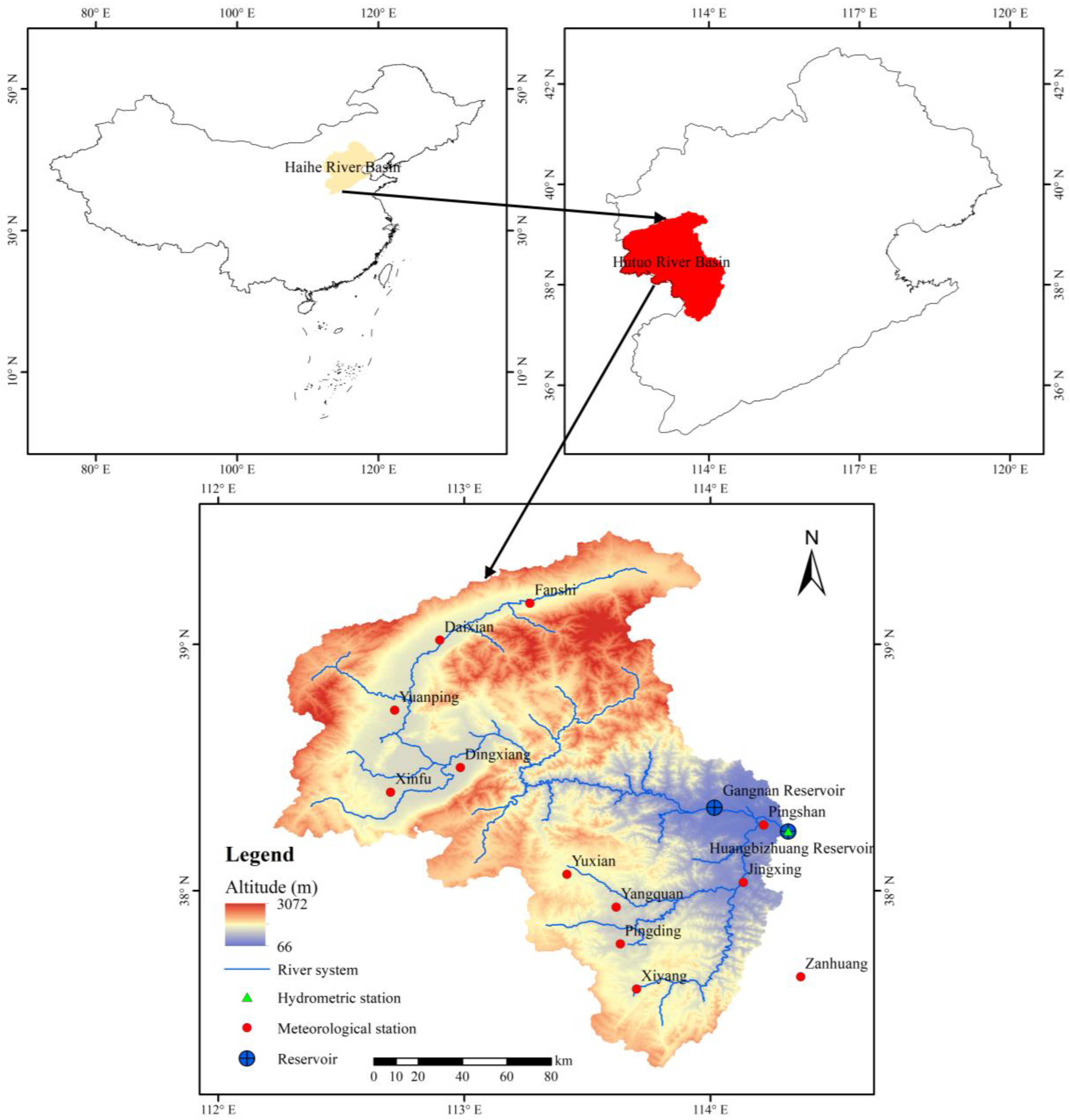
2. Overview of Research Area
3. Methodology
3.1. SWAT Model
3.2. Data Preparation
3.3. Calibration and Validation
3.4. Analysis of Parameter Sensitivity
4. Results
4.1. Calibration and Validation of SWAT
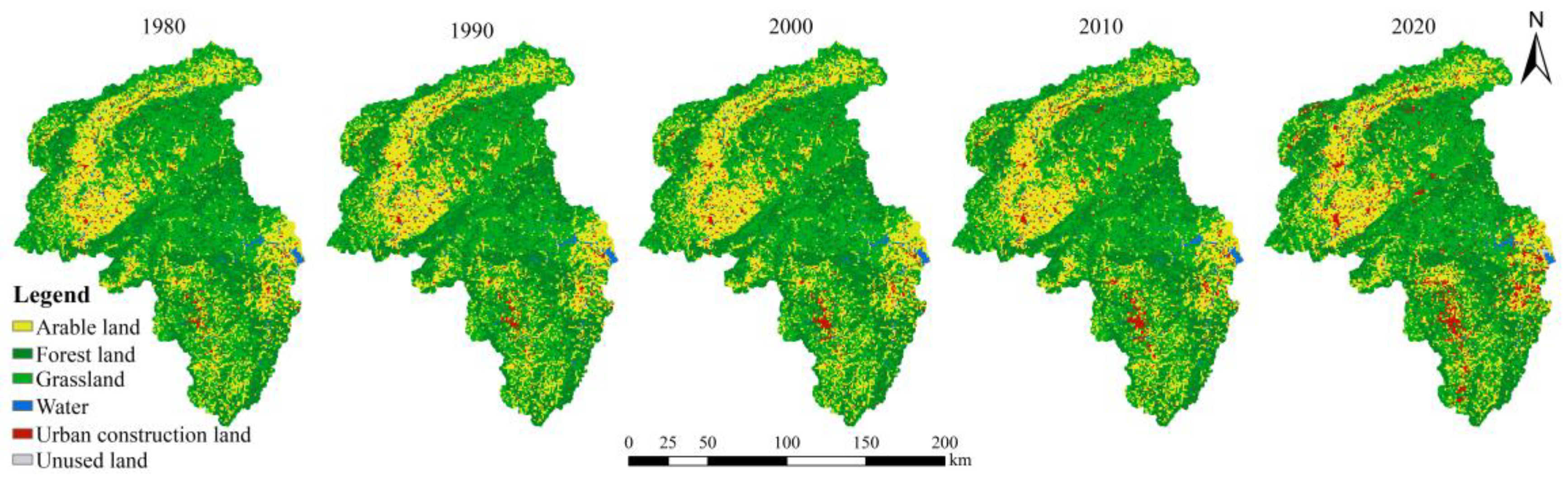
4.2. Analysis of Land-Use Change
4.3. Analysis of Results
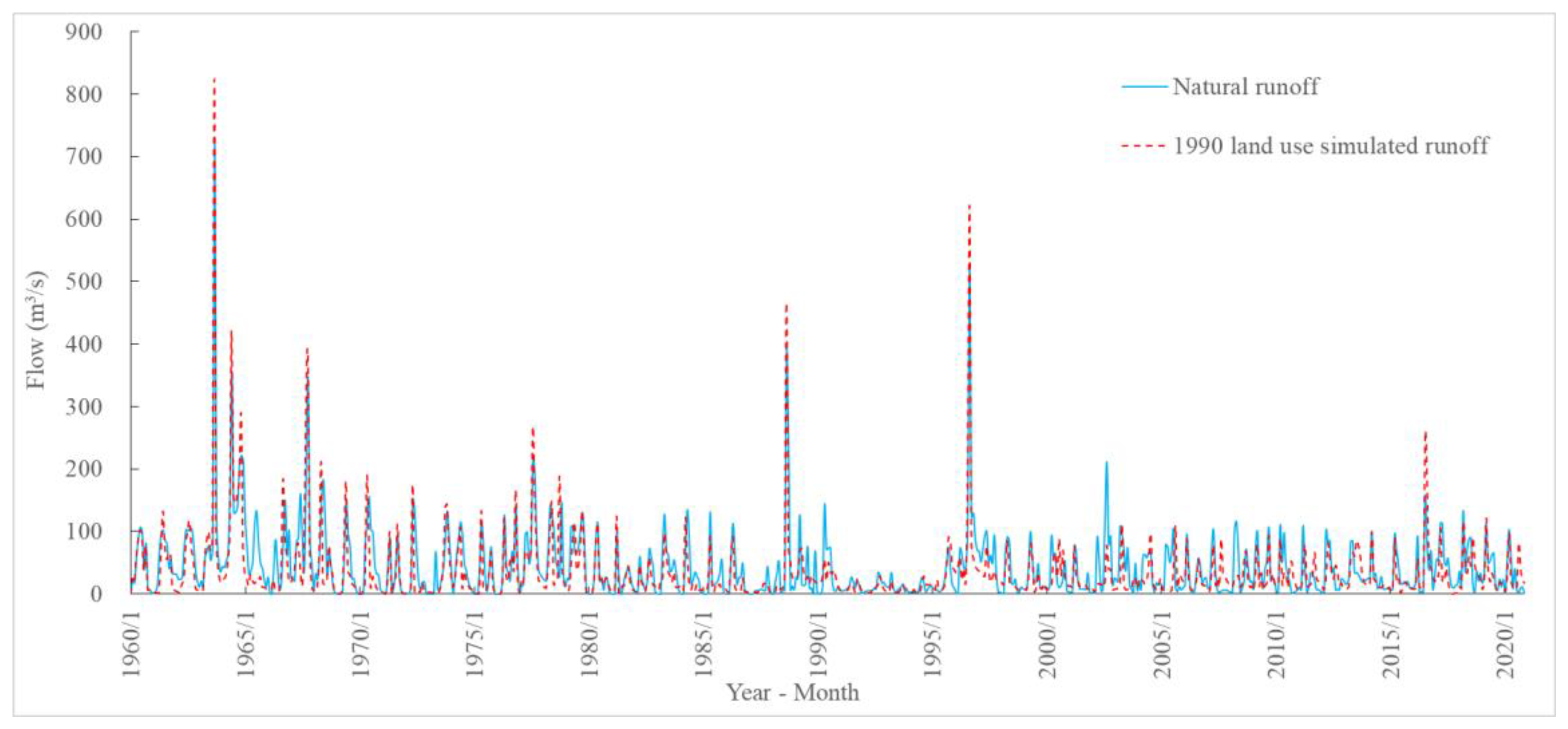
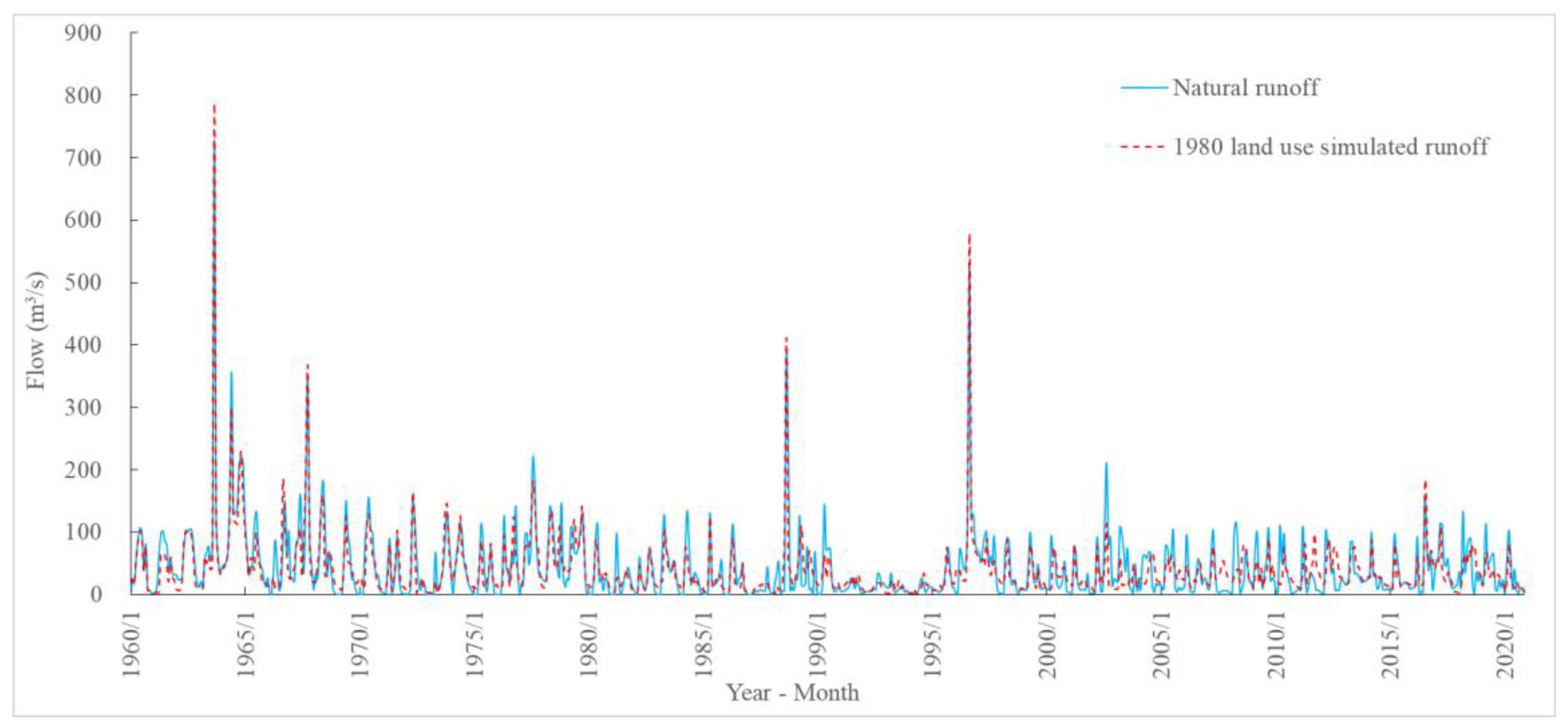
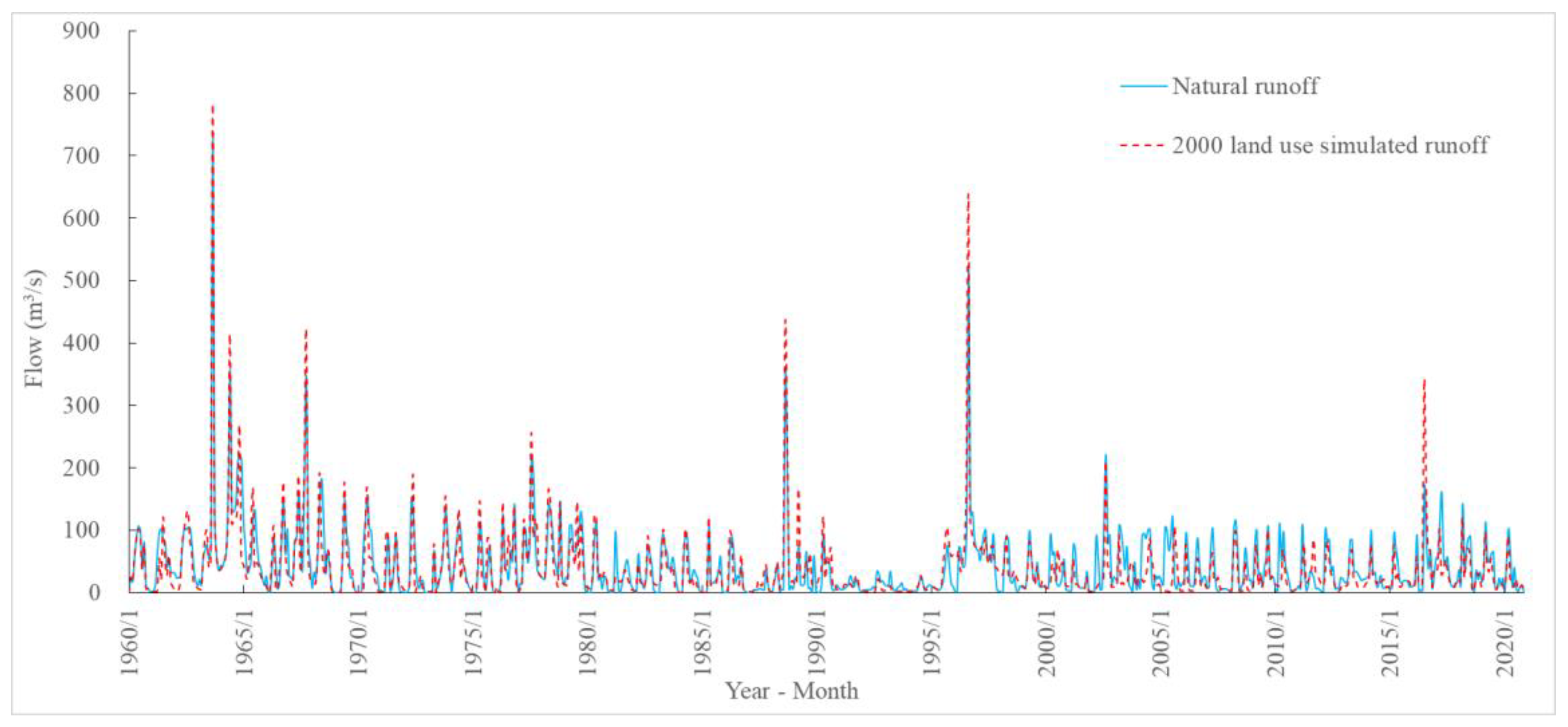
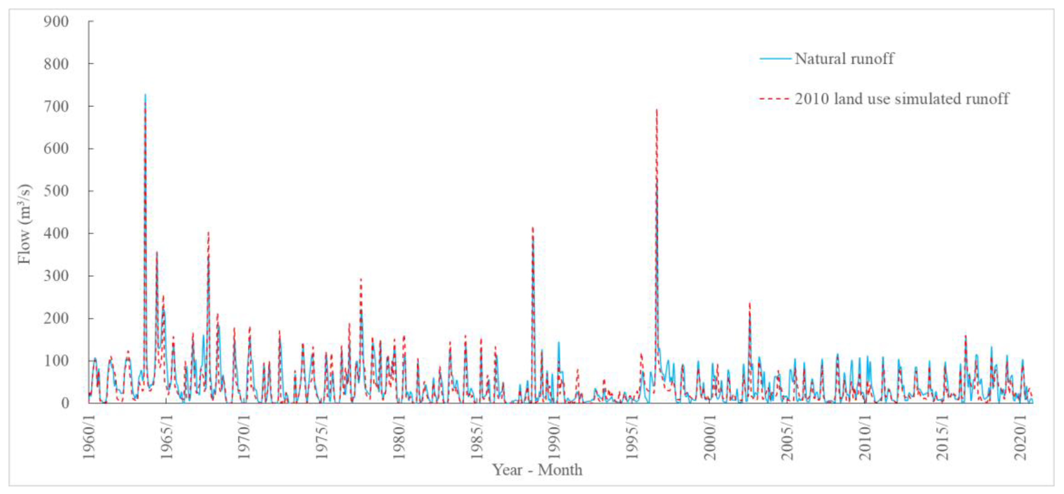
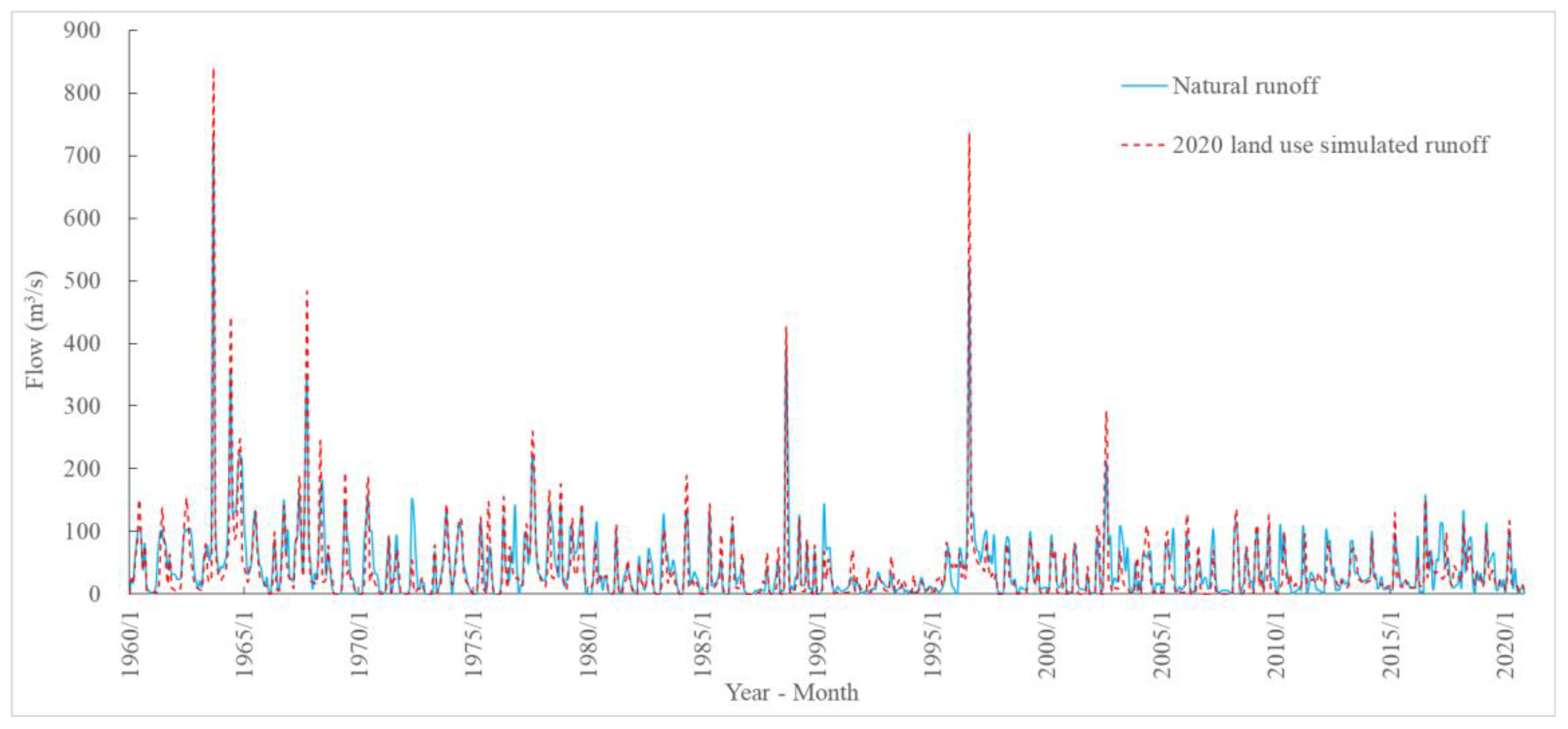
4.3.1. Runoff Analysis under Different Land-Use Scenarios
4.3.2. Analysis of Runoff Influenced by Land-Use Changes in Each Period
5. Discussion
6. Conclusions and Suggestions
- (1)
- The area of urban construction land in the research region gradually increased from 1980 to 1990, 2000, 2010, and 2020, with an overall increase of 1.5 times by 2020 when compared to 1980;
- (2)
- The areas of arable land, forest land, and grassland decreased gradually, with a total decrease of 704 km2 and a change rate of −3.1%;
- (3)
- Flood peak and annual runoff volume increased by 25.8 and 18.7%, respectively.
Author Contributions
Funding
Institutional Review Board Statement
Informed Consent Statement
Data Availability Statement
Acknowledgments
Conflicts of Interest
References
- Gu, D.; Tan, B. Impact of land use on hydrology and environment. Harnessing Huaihe River 1987, 5, 47–48. (In Chinese) [Google Scholar]
- Rui, X.; Jiang, C. Review of research of hydro-geomorphological processes interaction. Adv. Water Sci. 2010, 21, 444–449. (In Chinese) [Google Scholar]
- Wang, R.; Kalin, L.; Kuang, W.; Tian, H. Individual and combined effects of land use/cover and climate change on Wolf Bay watershed streamflow in southern Alabama. Hydrol. Process. 2014, 28, 5530–5546. [Google Scholar] [CrossRef]
- Smiraglia, D.; Ceccarelli, T.; Bajocco, S.; Perini, L.; Salvati, L. Unraveling Landscape Complexity: Land Use/Land Cover Changes and Landscape Pattern Dynamics (1954–2008) in Contrasting Peri-Urban and Agro-Forest Regions of Northern Italy. Environ. Manag. 2015, 56, 916–932. [Google Scholar] [CrossRef]
- Abuelaish, B.; Olmedo, M.T.C. Scenario of land use and land cover change in the Gaza Strip using remote sensing and GIS models. Arabian J. Geosci. 2016, 9, 274–287. [Google Scholar] [CrossRef] [Green Version]
- Psilovikos, A.; Katsada, A.; Malamataris, D.; Papathanasiou, T.; Psilovikos, T.; Spiridis, A. Impacts of Land Use and Land Cover Change in a Mediterranean Mountainous Area on Surface Runoff During the Period 1945–2018. In Proceedings of the 17th International Conference on Environmental Science and Technology (CEST 2021), Athens, Greece, 1–4 September 2021; Global NEST: Athens, Greece, 2021. [Google Scholar]
- Mulvaney, T.J. On the use of self-registering rain and flood gauges in making observations of the relations of rainfall and flood discharges in a given catchment. Proc. Inst. Civ. Eng. Irel. 1851, 4, 19–31. [Google Scholar]
- Bosch, J.M.; Hewlett, J.D. A review of catchment experiments to determine the effect of vegetation changes on water yield and evapotranspiration. J. Hydrol. 1982, 55, 3–23. [Google Scholar] [CrossRef]
- Bari, M.A.; Smettem, K.R.J.; Sivapalan, M. Understanding changes in annual runoff following land use changes: A systematic data-based approach. Hydrol. Process. 2005, 19, 2463–2479. [Google Scholar] [CrossRef]
- Mu, X.; Wang, W.; Xu, X. The influence of the soil and water conservation on the surface runoff in the watersheds in the gully plateau region of Loess Plateau. J. Hydraul. Eng. 1999, 2, 73–77. (In Chinese) [Google Scholar]
- Chen, J.; Li, X. The impact of forest change on watershed hydrology—Discussing some controversies on forest hydrology. J. Nat. Resour. 2001, 5, 474–480. (In Chinese) [Google Scholar]
- Wang, F.; Duan, K.; Fu, S.; Gou, F.; Liang, W.; Yan, J.; Zhang, W. Partitioning climate and human contributions to changes in mean annual streamflow based on the Budyko complementary relationship in the Loess Plateau, China. Sci. Total Environ. 2019, 665, 579–590. [Google Scholar] [CrossRef] [PubMed]
- Zhang, J.; Zhang, C.; Bao, Z.; Li, M.; Wang, G.; Guan, Z.; Liu, C. Analysis of the effects of vegetation changes on runoff in the Huang-Huai-Hai River basin under global change. Adv. Water Sci. 2021, 32, 813–823. (In Chinese) [Google Scholar]
- Lei, Z.; Fu, J.; Luo, J.; Cao, L. Attribution analysis of runoff changes in the Sanchuan River Basin of Shanxi Province from the perspective of landscape patterns. Acta Ecol. Sin. 2022, 42, 4946–4958. (In Chinese) [Google Scholar]
- Khoie, M.M.M.; Nasseri, M.; Banihashemi, M.A. Determining the spatial contributions of land use changes on the streamflow and sediment transport regimes: A case study of the Gorganroud watershed in Iran. Environ. Sci. Pollut. Res. 2023, 1, 25478–25485. [Google Scholar] [CrossRef] [PubMed]
- Cuo, L.; Zhang, Y.; Gao, Y.; Hao, Z.; Cairang, L. The impacts of climate change and land cover/use transition on the hydrology in the upper Yellow River Basin, China. J. Hydrol. 2013, 502, 37–52. [Google Scholar] [CrossRef]
- Liu, Z.; Cuo, L.; Li, Q.; Liu, X.; Ma, X.; Liang, L.; Ding, J. Impacts of climate change and land use/cover change on streamflow in Beichuan River Basin in Qinghai Province, China. Water 2020, 12, 1198. [Google Scholar] [CrossRef] [Green Version]
- Khorn, N.; Ismail, M.H.; Nurhidayu, S.; Kamarudin, N.; Sulaiman, M.S. Land use/land cover changes and its impact on runoff using SWAT model in the upper Prek Thnot watershed in Cambodia. Environ. Earth Sci. 2022, 81, 466. [Google Scholar] [CrossRef]
- Zhang, T.; Chen, Y.; Qi, W.; Zhang, Q.; Zhang, K. Effects of Land-use Change on the Spatio-temporal Patterns of Runoff and Sediment in the Danjiang River Basin. Resour. Environ Yangtze Basin. 2022, 31, 1797–1811. (In Chinese) [Google Scholar]
- Tasgara, T.D.; Kumar, B. Assessment of land use/land cover change impact on streamflow: A case study over upper Guder Catchment, Ethiopia. Sustain. Water Resour. Manag. 2023, 9, 6. [Google Scholar] [CrossRef]
- Tang, J.; Hu, X.; Wei, B.; Luo, Z.; Zhao, S.; Wang, Y. Land Use Change Prediction and Hydrological Response Assessment of Watershed Based on FLUS Model. J. Yangtze River Sci. Res. 2022, 39, 63–69. (In Chinese) [Google Scholar]
- Ahmadi, A.; Jalali, J.; Mohammadpour, A. Future runoff assessment under climate change and land-cover alteration scenarios: A case study of the Zayandeh-Roud dam upstream watershed. Hydrol. Res. 2022, 53, 1372–1392. [Google Scholar] [CrossRef]
- Mfwango, L.H.; Ayenew, T.; Mahoo, H.F. Impacts of climate and land use/cover changes on streamflow at Kibungo sub-catchment, Tanzania. Heliyon 2022, 8, 11285. [Google Scholar] [CrossRef]
- Liu, Z.; Lan, C. Investigating the mechanisms of streamflow change in the Beichuan River Basin, Qinghai Province: Based on modeling and statistic analyses. Prog. Geogr. 2022, 41, 304–315. (In Chinese) [Google Scholar] [CrossRef]
- Zhao, P.; Feng, W.; Bu, X.; Cui, Q.; Zheng, Q.; Xu, X. The Variation of Water Resources and the Influencing Factors of Hutuo River in Mountainous Regions in Recent 55 Years. Res. Soil Water Conserv. 2015, 22, 128–132. (In Chinese) [Google Scholar]
- Wang, S.; Li, W.; Wang, J. Analysis on runoff variation characteristics and its influence factors in the upper reaches of Hutuo River Basin. J. Gansu Agric. Univ. 2020, 55, 162–169. (In Chinese) [Google Scholar]
- Miao, Z.; Li, N.; Lu, M.; Xu, L. Attribution analysis of runoff variations in the upper reaches of Hutuo River Basin. J. Beijing Norm. Univ. Nat. Sci. 2021, 57, 756–767. (In Chinese) [Google Scholar]
- Xi, M.; Zhao, Z.; Wu, P.; Zhao, Y. Changes and Predictions of Land Use in Mountain Section of the Hutuo RiverBasin Based on lmproved CA-Markov Model. J. Northwest For. Univ. 2021, 36, 150–158. [Google Scholar]
- Easton, Z.M.; Fuka, D.R.; Walter, M.T.; Cowan, D.M.; Schneiderman, E.M.; Steenhuis, T.S. Re-conceptualizing the soil and water assessment tool (SWAT) model to predict runoff from variable source areas. J. Hydrol. 2008, 348, 279–291. (In Chinese) [Google Scholar] [CrossRef]
- Tripathi, M.; Panda, R.; Raghuwanshi, N. Identification and Prioritisation of Critical Sub-watersheds for Soil Conservation Management using the SWAT Model. Biosyst. Eng. 2003, 85, 365–379. [Google Scholar] [CrossRef]
- Arnold, J.G.; Moriasi, D.N.; Gassman, P.W.; Abbaspour, K.C.; White, M.J.; Srinivasan, R.; Santhi, C.; Harmel, R.D.; van Griensven, A.; Van Liew, M.W.; et al. SWAT: Model Use, Calibration, and Validation. Trans. ASABE 2012, 55, 1491–1508. [Google Scholar] [CrossRef]
- Narsimlu, B.; Gosain, A.K.; Chahar, B.R. Assessment of Future Climate Change Impacts on Water Resources of Upper Sind River Basin, India Using SWAT Model. Water Resour. Manag. 2013, 27, 3647–3662. [Google Scholar] [CrossRef]
- Sun, C.; Ren, L. Assessment of surface water resources and evapotranspiration in the Haihe River basin of China using SWAT model. Hydrol. Process. 2013, 27, 1200–1222. [Google Scholar] [CrossRef]
- Schuol, J.; Abbaspour, K.C.; Srinivasan, R.; Yang, H. Estimation of freshwater availability in the West African sub-continent using the SWAT hydrologic model. J. Hydrol. 2008, 352, 30–49. [Google Scholar] [CrossRef]
- Yang, J.; Reichert, P.; Abbaspour, K.C.; Xia, J.; Yang, H. Comparing uncertainty analysis techniques for a SWAT application to the Chaohe Basin in China. J. Hydrol. 2008, 358, 1–23. [Google Scholar] [CrossRef]
- Abbaspour, K.C.; Johnson, A.M.; Van Genuchten, T. Estimating uncertain flow and transport parameters using a sequential uncertainty fitting procedure. Vadose Zone J. 2004, 3, 1340–1352. [Google Scholar] [CrossRef]
- Gupta, H.V.; Sorooshian, S.; Yapo, P.O. Toward improved calibration of hydrologic models: Multiple and noncommensurable measures of information. Water Resour. Res. 1998, 34, 751–763. [Google Scholar] [CrossRef] [Green Version]
- Ostad, A.A.K. Arrangement of watershed from overflowing lookout applying the SWAT prototypical and SUFI-2 (case study: Kasiliyan watershed, Mazandaran Province, Iran). Appl. Water Sci. 2022, 12, 196. [Google Scholar] [CrossRef]
- Nash, J.E.; Sutcliffe, J.V. River flow forecasting through conceptual models part I: A discussion of principles. J. Hydrol. 1970, 10, 282–290. [Google Scholar] [CrossRef]
- Santhi, C.; Arnold, J.G.; Williams, J.R. Validation of the SWAT model on a large river basin with point and nonpoint sources. J. Am. Water Resour. Assoc. 2001, 37, 1169–1188. [Google Scholar] [CrossRef]
- Moriasi, D.N.; Arnold, J.G.; Van Liew, M.W.; Bingner, R.L.; Harmel, R.D.; Veith, T.L. Model Evaluation Guidelines for Systematic Quantification of Accuracy in Watershed Simulations. Trans. ASABE 2007, 50, 885–900. [Google Scholar] [CrossRef]
- Zuo, D.; Xu, Z.; Peng, D.; Song, J.; Cheng, L.; Wei, S.; Abbaspour, K.C.; Yang, H. Simulating spatiotemporal variability of blue and green water resources availability with uncertainty analysis. Hydrol. Process. 2015, 29, 1942–1955. [Google Scholar] [CrossRef]
- Chang, J.; Wang, Y.; Istanbulluoglu, E.; Bai, T.; Huang, Q.; Yang, D.; Huang, S. Impact of climate change and human activities on runoff in the Weihe River Basin, China. Quat. Int. 2015, 380–381, 169–179. [Google Scholar] [CrossRef]
- Zhai, Z.; Peng, J.; Li, C. SWAT model based study on hydrological effect in Hutuo River Basin. Water Resour. Hydropower Eng. 2010, 41, 5–9. (In Chinese) [Google Scholar]
- Francesco, G.; Alexandra, G.K.; Daniel, K.; Seyed, H.A.; Rafael, S.O.; Maria, U.; Pierre, G. Tall Amazonian forests are less sensitive to precipitation variability. Nat. Geosci. 2018, 11, 405–409. [Google Scholar]
- Meusburger, K.; Trotsiuk, V.; SchmidtWalter, P.; Baltensweiler, A.; Brun, P.; Bernhard, F.; Gharun, M.; Habel, R.; Hagedorn, F.; Köchli, R.; et al. Soil-plant interactions modulated water availability of Swiss forests during the 2015 and 2018 droughts. Global Change Biol. 2022, 28, 5928–5944. [Google Scholar] [CrossRef]
- Zhang, P.; Hu, X.; Chen, G.; Zeng, J.; Yin, K.; Qian, J.; Zhang, Q. Comparison of saturated hydraulic conductivity among different land use types of Taian brown loam. J. Drain. Irrig. Mach. Eng. 2020, 38, 403–408. (In Chinese) [Google Scholar]
- Yang, R.; Xiao, H.; Feng, T.; Wang, F.; Zhao, Z.; Guo, Z.; Wang, S.; Zhu, J.; Li, S. Evaluation on Benefits of Different Soil and Water Conservation Measures UnderCastanea mollissima Bl. Forest around Mivun Reservoir. Res. Soil Water Conserv. 2022, 29, 28–35. (In Chinese) [Google Scholar]
- Yangbo, C.; Haolan, Z.; Hui, Z.; Guoming, D.; Zhou, J. Urban flood risk warning under rapid urbanization. Environ. Res. 2015, 139, 3–10. [Google Scholar]
- Jin, D. Impact of forest on hydrological elements. Yangtze River 1989, 01, 28–35. (In Chinese) [Google Scholar]
- Jackson, R.B.; Jobbáagy, E.G.; Avissar, R.; Roy, S.B.; Barrett, D.J.; Cook, C.W.; Farley, K.A.; Maitre, D.C.; McCarl, B.A.; Murray, B.C. Trading Water for Carbon with Biological Carbon Sequestration. Science 2005, 310, 1944–1947. [Google Scholar] [CrossRef] [Green Version]
- Li, H.; Si, B.; Pute, W.; Jeffrey, J.M. Water mining from the deep critical zone by apple trees growing on loess. Hydrol. Process. 2019, 33, 320–327. [Google Scholar] [CrossRef]
- Zhang, W.; Pang, J. Construction of the sponge city shall be an important part of the urban water management in new era. Water Resour. Dev. Res. 2014, 14, 5–7. (In Chinese) [Google Scholar]
- Carol, R.J. Identification and quantification of the hydrological impacts of imperviousness in urban catchments: A review. J. Environ. Manag. 2011, 92, 1438–1448. [Google Scholar]
- Shaojun, X.; Christer, N. Dynamics of Leaf Litter Accumulation and Its Effects on Riparian Vegetation: A Review. Bot. Rev. 1997, 63, 240–264. [Google Scholar]


| Number | Data Type | Resolution | Year | Source |
|---|---|---|---|---|
| 1 | Meteorological data | Daily | 1960–2020 | China Meteorological Date Service Center |
| 2 | Runoff data | Daily | 1960–2020 | Hydrological Yearbook of the Hai River Basin |
| 3 | Digital Elevation Map | 30 m | 2020 | Geospatial Data Cloud |
| 4 | Land-use map | 1 km | 1980, 1990, 2000, 2010, and 2020 | Resource and Environmental Science and Data Center, Chinese Academy of Sciences |
| 5 | Soil map | 1:1 million | - | World Soil Database |
| 6 | Monthly outflow of Huangbizhuang Reservoir | Daily | 1960–2020 | Hydrological Yearbook of the Hai River Basin |
| Land-Use Period | Period | Warm-Up Period | Calibration Period | Validation Period |
|---|---|---|---|---|
| 1980 | 1960–1979 | 1960 | 1961–1970 | 1971–1979 |
| 1990 | 1980–1989 | 1980 | 1981–1985 | 1986–1989 |
| 2000 | 1990–1999 | 1990 | 1991–1995 | 1996–1999 |
| 2010 | 2000–2009 | 2000 | 2001–2005 | 2006–2009 |
| 2020 | 2010–2020 | 2010 | 2011–2015 | 2016–2020 |
| Parameter | 1960–1979 | 1980–1989 | 1990–1999 | 2000–2009 | 2010–2020 | |||||
|---|---|---|---|---|---|---|---|---|---|---|
| t-st. | p Value | t-st. | p Value | t-st. | p Value | t-st. | p Value | t-st. | p Value | |
| CN2 | −7.04 | 0.00 | −4.94 | 0.13 | −5.27 | 0.12 | −4.56 | 0.14 | 0.22 | 0.83 |
| GW_REVAP | −0.21 | 0.83 | 1.91 | 0.31 | 1.88 | 0.31 | 1.77 | 0.33 | 0.56 | 0.60 |
| SOL_AWC | 0.74 | 0.47 | 0.62 | 0.64 | 0.77 | 0.58 | 0.43 | 0.74 | 1.45 | 0.21 |
| SOL_K | −0.70 | 0.49 | −1.56 | 0.36 | −1.49 | 0.38 | −1.46 | 0.38 | 0.16 | 0.88 |
| ALPHA_BF | −1.02 | 0.32 | 0.18 | 0.89 | 0.13 | 0.92 | 0.19 | 0.88 | 0.43 | 0.68 |
| GW_DELAY | −0.80 | 0.43 | 0.75 | 0.59 | 0.86 | 0.55 | 0.69 | 0.62 | 0.75 | 0.49 |
| GWQMN | −0.30 | 0.77 | 1.17 | 0.45 | 1.27 | 0.42 | 1.11 | 0.47 | −0.76 | 0.48 |
| ESCO | −0.77 | 0.45 | −0.39 | 0.76 | −0.31 | 0.81 | −0.34 | 0.79 | −0.03 | 0.97 |
| CH_N2 | −0.94 | 0.36 | 0.84 | 0.56 | 0.77 | 0.58 | 0.82 | 0.56 | 0.47 | 0.66 |
| Parameter | Parameter Range | Land-Use Scenarios | |||||
|---|---|---|---|---|---|---|---|
| Lower Limit | Upper Limit | 1980 | 1990 | 2000 | 2010 | 2020 | |
| CN2 | 35.00 | 98.00 | 43.90 | 80.75 | 29.66 | 87.00 | 67.98 |
| GW_REVAP | 0.02 | 0.20 | 0.02 | 0.02 | 0.02 | 0.02 | 0.02 |
| SOL_AWC(1) | 0.00 | 1.00 | 0.16 | 0.42 | 0.18 | 0.14 | 0.20 |
| SOL_K(1) | 0.00 | 2000.00 | 8.36 | 5.16 | 3.42 | 18.26 | 25.93 |
| ALPHA_BF | 0.00 | 1.00 | 1.18 | 1.02 | 0.07 | 0.16 | 0.80 |
| GW_DELAY | 0.00 | 500.00 | 343.65 | 450.59 | 278.09 | 299.97 | 412.85 |
| GWQMN | 0.00 | 5000.00 | 1.41 | 1.44 | 2.05 | 2.05 | 3.12 |
| ESCO | 0.00 | 1.00 | 0.05 | 0.04 | 0.60 | 0.55 | 0.17 |
| CH_N2 | −0.01 | 0.30 | 0.06 | 0.03 | 0.20 | 0.31 | 0.16 |
| Land-Use Scenarios | Calibration Period | Validation Period | ||||
|---|---|---|---|---|---|---|
| Period | R2 | NSE | Period | R2 | NSE | |
| 1980 | 1961–1970 | 0.83 | 0.82 | 1971–1979 | 0.65 | 0.63 |
| 1990 | 1981–1985 | 0.89 | 0.88 | 1986–1989 | 0.64 | 0.54 |
| 2000 | 1991–1995 | 0.82 | 0.65 | 1996–1999 | 0.96 | 0.73 |
| 2010 | 2001–2005 | 0.64 | 0.62 | 2006–2009 | 0.66 | 0.64 |
| 2020 | 2011–2015 | 0.68 | 0.65 | 2016–2020 | 0.64 | 0.63 |
| Land-Use Type | Area of Land-Use Type in Each Decade (km2) | Rate of Change of Land-Use Area by Decade (%) | ||||||||
|---|---|---|---|---|---|---|---|---|---|---|
| 1980 | 1990 | 2000 | 2010 | 2020 | 1980 | 1990 | 2000 | 2010 | 2020 | |
| Arable land | 6282 | 6229 | 6316 | 6236 | 6113 | - | −0.8 | 1.4 | −1.3 | −2.0 |
| Forest land | 6932 | 6903 | 6841 | 6820 | 6718 | - | −0.4 | −0.9 | −0.3 | −1.5 |
| Grassland | 9769 | 9794 | 9765 | 9731 | 9445 | - | 0.3 | −0.3 | −0.4 | −2.9 |
| Water | 358 | 361 | 332 | 338 | 306 | - | 0.7 | −8.0 | 1.9 | −9.5 |
| Urban construction land | 528 | 581 | 636 | 761 | 1314 | - | 10.0 | 9.5 | 19.6 | 72.6 |
| Unused land | 62 | 63 | 42 | 45 | 37 | - | 1.6 | −34.4 | 9.2 | −18.2 |
| Simulation Period | Natural Value (m3/s) | Simulated Values (m3/s) | Simulated Values—Natural Values (m3/s) | (Simulated Value—Natural Value)/Natural Value (%) | ||||||||||||
|---|---|---|---|---|---|---|---|---|---|---|---|---|---|---|---|---|
| 1980 | 1990 | 2000 | 2010 | 2020 | 1980 | 1990 | 2000 | 2010 | 2020 | 1980 | 1990 | 2000 | 2010 | 2020 | ||
| 1960–1979 | 188.0 | 181.0 | 209.6 | 214.6 | 207.6 | 219.7 | −7.0 | 21.6 | 26.7 | 19.7 | 31.7 | −5.7 | 9.9 | 14.8 | 12.7 | 15.7 |
| 1980–1989 | 134.6 | 113.4 | 124.9 | 131.2 | 151.1 | 142.1 | −21.2 | −9.8 | −3.4 | 16.5 | 7.5 | −23.0 | −16.2 | −5.1 | 11.4 | 5.8 |
| 1990–1999 | 115.8 | 107.9 | 110.6 | 121.1 | 132.9 | 134.0 | −7.9 | −5.2 | 5.3 | 17.1 | 18.2 | −11.7 | −14.5 | −9.0 | 24.1 | 22.2 |
| 2000–2009 | 108.3 | 75.3 | 89.5 | 95.8 | 100.0 | 117.9 | −33.0 | −18.8 | −12.5 | −8.4 | 9.6 | −26.9 | −9.7 | −12.1 | −9.4 | 7.7 |
| 2010–2020 | 111.1 | 93.2 | 110.2 | 110.1 | 94.0 | 104.5 | −18.0 | −0.9 | −1.0 | −17.1 | −6.6 | −16.8 | −3.2 | −6.2 | −15.8 | −5.1 |
| 1960–2020 | 131.6 | 114.2 | 129.0 | 134.6 | 137.1 | 143.7 | −17.4 | −2.6 | 3.0 | 5.5 | 12.1 | −16.8 | −6.7 | −3.5 | 4.6 | 9.3 |
| Simulation Period | Natural Value (m3/s) | Simulated Values (m3/s) | Simulated Values—Natural Values (m3/s) | (Simulated Value—Natural Value)/Natural Value (%) | ||||||||||||
|---|---|---|---|---|---|---|---|---|---|---|---|---|---|---|---|---|
| 1980 | 1990 | 2000 | 2010 | 2020 | 1980 | 1990 | 2000 | 2010 | 2020 | 1980 | 1990 | 2000 | 2010 | 2020 | ||
| 1960–1979 | 60.9 | 61.9 | 67.9 | 65.9 | 68.9 | 69.9 | 1.0 | 7.0 | 5.0 | 8.0 | 9.0 | 1.6 | 11.5 | 8.2 | 13.1 | 14.8 |
| 1980–1989 | 31.5 | 29.9 | 29.5 | 31.1 | 35.5 | 36.5 | −1.6 | −2.0 | −0.5 | 4.0 | 5.0 | −5.1 | −6.3 | −1.5 | 12.7 | 15.8 |
| 1990–1999 | 31.8 | 30.7 | 28.1 | 34.6 | 32.8 | 33.8 | −1.1 | −3.7 | 2.8 | 1.0 | 2.0 | −3.6 | −11.7 | 8.7 | 3.1 | 6.3 |
| 2000–2009 | 35.7 | 31.5 | 29.1 | 29.8 | 32.7 | 41.7 | −4.2 | −6.6 | −6.0 | −3.0 | 6.0 | −11.8 | −18.5 | −16.7 | −8.4 | 16.8 |
| 2010–2020 | 34.5 | 27.5 | 31.2 | 29.3 | 29.5 | 33.5 | −7.0 | −3.3 | −5.1 | −5.0 | −1.0 | −20.3 | −9.5 | −14.9 | −14.5 | −2.9 |
| 1960–2020 | 38.9 | 36.3 | 37.2 | 38.1 | 39.9 | 43.1 | −2.6 | −1.7 | −0.8 | 1.0 | 4.2 | −6.7 | −4.4 | −2.0 | 2.6 | 10.8 |
Disclaimer/Publisher’s Note: The statements, opinions and data contained in all publications are solely those of the individual author(s) and contributor(s) and not of MDPI and/or the editor(s). MDPI and/or the editor(s) disclaim responsibility for any injury to people or property resulting from any ideas, methods, instructions or products referred to in the content. |
© 2023 by the authors. Licensee MDPI, Basel, Switzerland. This article is an open access article distributed under the terms and conditions of the Creative Commons Attribution (CC BY) license (https://creativecommons.org/licenses/by/4.0/).
Share and Cite
Liu, B.; Yang, J.; Sha, J.; Luo, Y.; Zhao, X.; Liu, R. Analysis of Runoff According to Land-Use Change in the Upper Hutuo River Basin. Water 2023, 15, 1138. https://doi.org/10.3390/w15061138
Liu B, Yang J, Sha J, Luo Y, Zhao X, Liu R. Analysis of Runoff According to Land-Use Change in the Upper Hutuo River Basin. Water. 2023; 15(6):1138. https://doi.org/10.3390/w15061138
Chicago/Turabian StyleLiu, Bin, Jie Yang, Jinxia Sha, Yun Luo, Xian Zhao, and Ruiting Liu. 2023. "Analysis of Runoff According to Land-Use Change in the Upper Hutuo River Basin" Water 15, no. 6: 1138. https://doi.org/10.3390/w15061138
APA StyleLiu, B., Yang, J., Sha, J., Luo, Y., Zhao, X., & Liu, R. (2023). Analysis of Runoff According to Land-Use Change in the Upper Hutuo River Basin. Water, 15(6), 1138. https://doi.org/10.3390/w15061138