
Economic Feasibility of Rainwater Harvesting Applications in the West Bank, Palestine


Abstract
1. Introduction
2. Materials and Methods
2.1. Study Area
2.2. Implementation of Eyebrow Terraces
2.2.1. Spatial Characterization Using Archetype Analysis
Precipitation
Slope
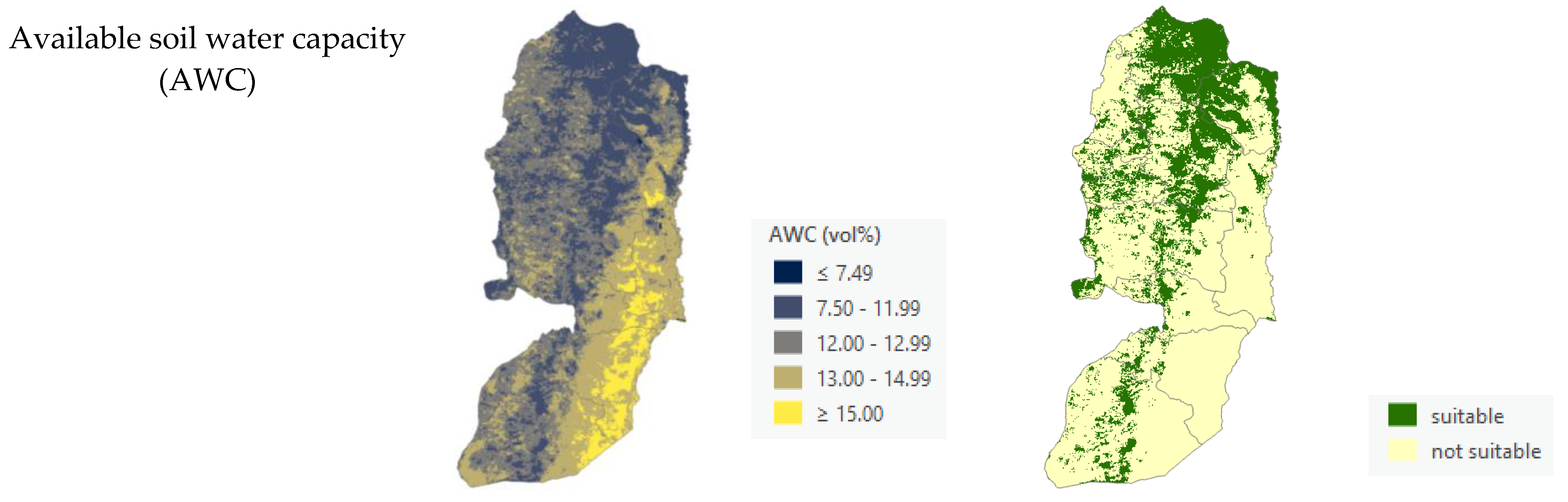
Available Soil Water Capacity
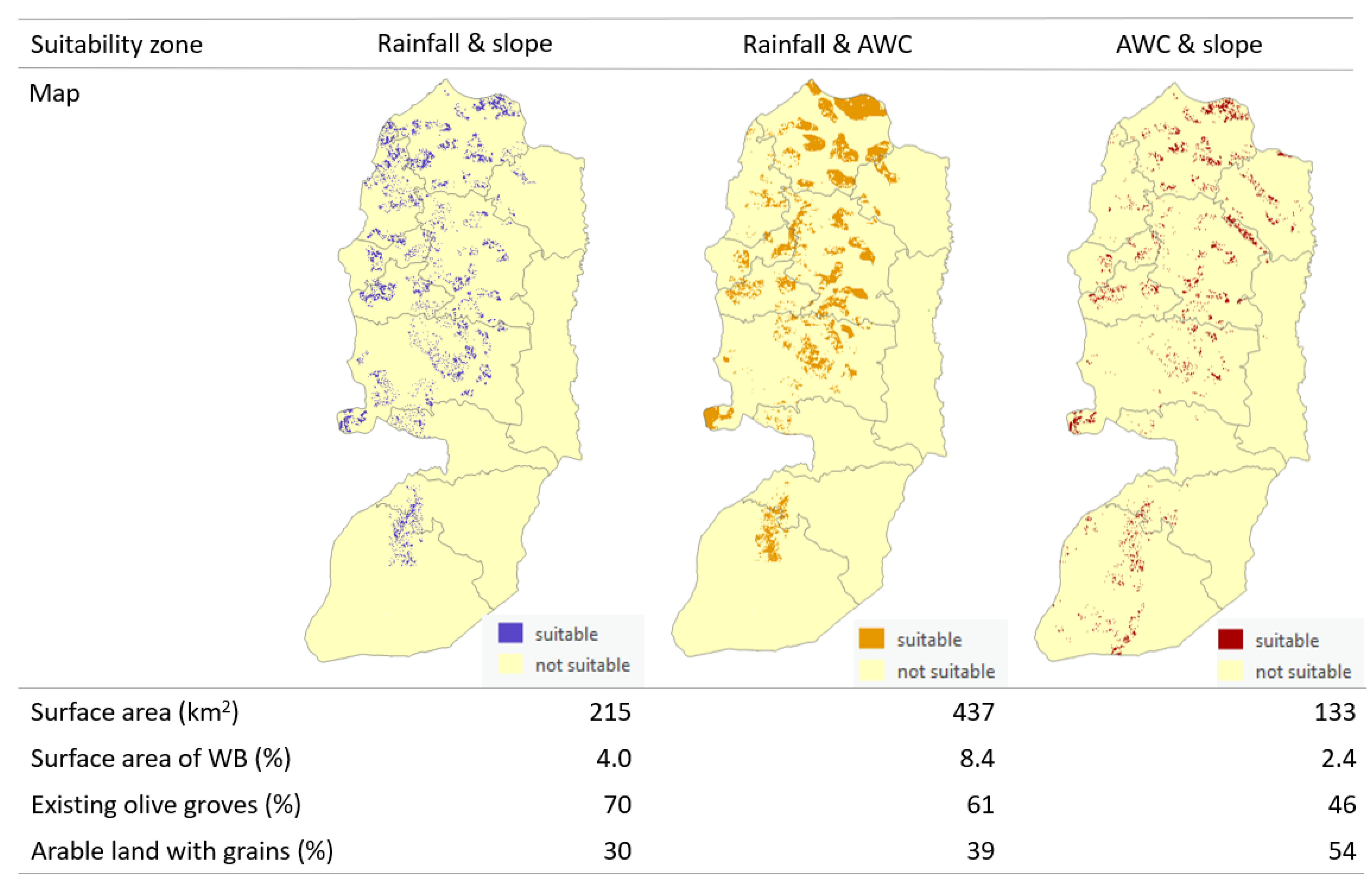
Suitability Zones
2.2.2. Crop–Water Balance Model
Dynamic Data Input
Static Data Input
Model Validation
2.3. Implementation of Rooftop Harvesting
2.4. Spatially Explicit Cost–Benefit Analysis
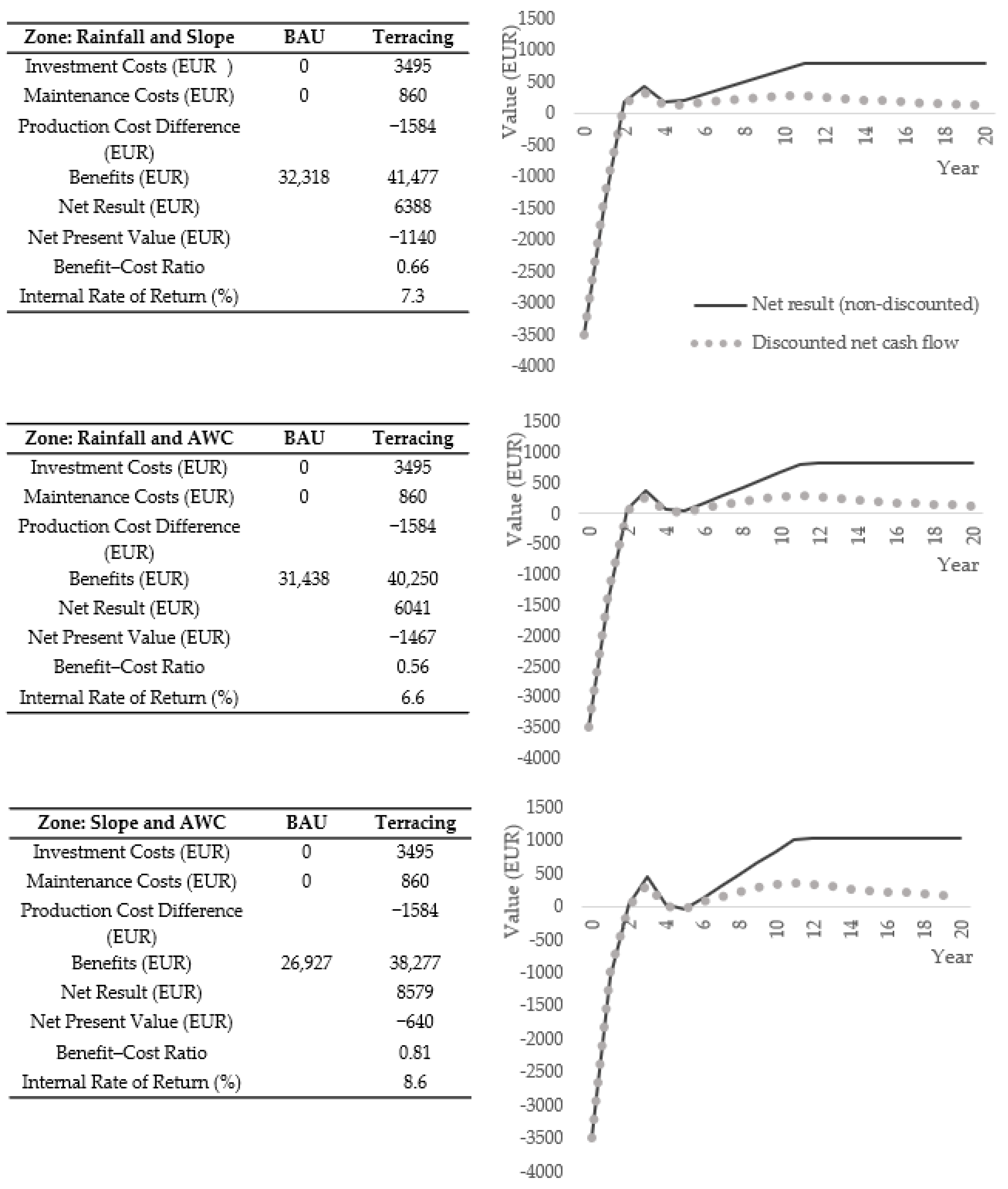
2.4.1. Eyebrow Terraces
2.4.2. Rooftop Harvesting
3. Results
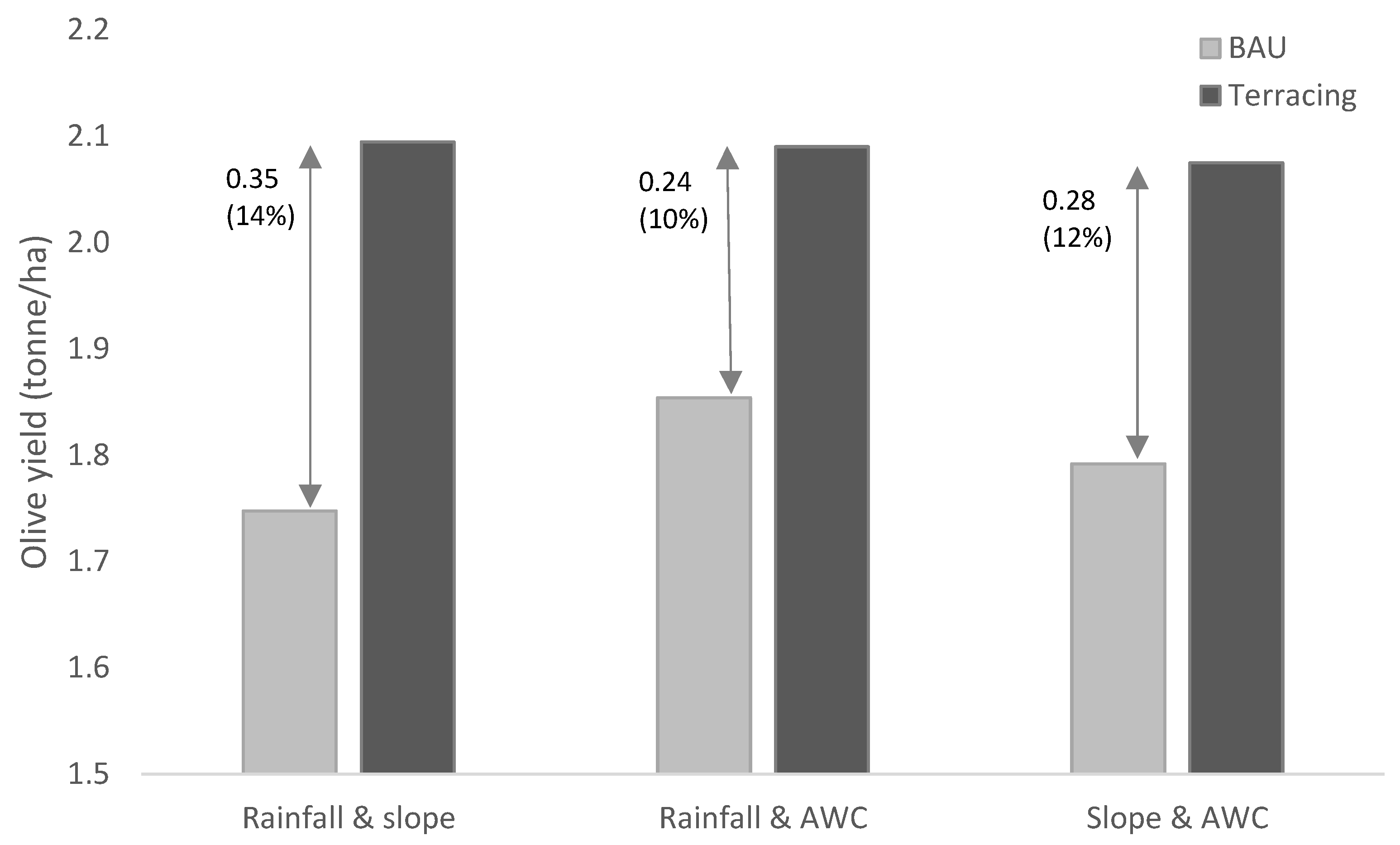
3.1. Eyebrow Terraces
3.2. Rooftop Harvesting
3.3. Cost–Benefit Analysis
3.3.1. Eyebrow Terraces
3.3.2. Rooftop Harvesting
4. Discussion
5. Conclusions
Supplementary Materials
Author Contributions
Funding
Data Availability Statement
Acknowledgments
Conflicts of Interest
References
- UNDP. Climate Change Adaptation Strategy and Programme of Action for the Palestinian Authority; United Nations Development Programme (UNDP) Programme of Assistance to the Palestinian People: Jerusalem, Palestine, 2010. [Google Scholar]
- State of Palestine. Sustainable Development Goals: Palestinian National Voluntary Review on the Implementation of the 2030 Agenda; State of Palestine: Jerusalem, Palestine, 2018.
- GERICS. Climate Fact Sheet of Israel—Jordan—Lebanon—Palestine—Syria; Climate Service Center: Hamburg, Germany, 2013. [Google Scholar]
- PCBS. Household Environmental Survey, 2011: Main Results (English Section); Palestinian Central Bureau of Statistics, Palestinian National Authority: Ramallah, Palestine, 2011.
- Adham, A.; Riksen, M.; Abed, R.; Shadeed, S.; Ritsema, C. Assessing Suitable Techniques for Rainwater Harvesting Using Analytical Hierarchy Process (AHP) Methods and GIS Techniques. Water 2022, 14, 2110. [Google Scholar] [CrossRef]
- Al-Salaymeh, A.; Al-Khatib, I.A.; Arafat, H.A. Towards sustainable water quality: Management of rainwater harvesting cisterns in southern Palestine. Water Resour Manag 2011, 25, 1721–1736. [Google Scholar] [CrossRef]
- Dile, Y.T.; Karlberg, L.; Temesgen, M.; Rockström, J. The role of water harvesting to achieve sustainable agricultural intensification and resilience against water related shocks in sub-Saharan Africa. Agric. Ecosyst. Environ. 2013, 181, 69–79. [Google Scholar] [CrossRef]
- Ngigi, S.N.; Savenije, H.H.G.; Rockström, J.; Gachene, C.K. Hydro-economic evaluation of rainwater harvesting and management technologies: Farmers’ investment options and risks in semi-arid Laikipia district of Kenya. Phys. Chem. Earth Parts A/B/C 2005, 30, 772–782. [Google Scholar] [CrossRef]
- Lebel, S.; Fleskens, L.; Forster, P.M.; Jackson, L.S.; Lorenz, S. Evaluation of in situ rainwater harvesting as an adaptation strategy to climate change for maize production in rainfed Africa. Water Resour. Manag. 2015, 29, 4803–4816. [Google Scholar] [CrossRef]
- Pandey, D.P.; Gupta, A.K.; Anderson, D.M. Rainwater harvesting as an adaptation to climate change. Curr. Sci. 2003, 85, 46–59. [Google Scholar]
- Velasco-Muñoz, J.F.; Aznar-Sánchez, J.A.; Batlles-delaFuente, A.; Dolores Fidelibus, M. Rainwater harvesting for agricultural irrigation: An analysis of global research. Water 2019, 11, 1320. [Google Scholar] [CrossRef]
- Assayed, A.; Hatokay, Z.; Al-Zoubi, R.; Azzam, S.; Qbailat, M.; Al-Ulayyan, A.; Saleem, M.A.; Bushnaq, S.; Maroni, R. On-site rainwater harvesting to achieve household water security among rural and peri-urban communities in Jordan. Resour. Conserv. Recycl. 2013, 73, 72–77. [Google Scholar] [CrossRef]
- Piemontese, L.; Castelli, G.; Fetzer, I.; Barron, J.; Liniger, H.; Harari, N.; Bresci, E.; Jaramillo, F. Estimating the global potential of water harvesting from successful case studies. Glob. Environ. Change 2020, 63, 102121. [Google Scholar] [CrossRef]
- Rodrigues de Sa Silva, A.C.; Mendonça Bimbato, A.; Perrella Balestieri, J.A.; Nogueira Vilanova, M.R. Exploring environmental, economic and social aspects of rainwater harvesting systems: A review. Sustain. Cities Soc. 2022, 76, 103475. [Google Scholar] [CrossRef]
- Adham, A.; Riksen, M.; Ouessar, M.; Ritsema, C. Identification of suitable sites for rainwater harvesting structures in arid and semi-arid regions: A review. Int. Soil Water Conserv. Res. 2016, 4, 108–120. [Google Scholar] [CrossRef]
- Jan, I. Socio-economic determinants of farmers’ adoption of rainwater harvesting systems in semi-arid regions of Pakistan. J. Agr Sci Tech. 2020, 22, 377–387. [Google Scholar]
- Sheikh, V. Perception of domestic rainwater harvesting by Iranian citizens. Sustain. Cities Soc. 2020, 60, 102278. [Google Scholar] [CrossRef]
- Al-Adamat, R.; AlAyyash, S.; Al-Amoush, H.; Al-Meshan, O.; Rawajfih, Z.; Shdeifat, A.; Al-Harahsheh, A.; Al-Farajat, M. The combination of indigenous knowledge and geo-informatics for water harvesting siting in the Jordanian Badia. J. Geogr. Inf. Syst. 2012, 4, 366–376. [Google Scholar] [CrossRef]
- Adham, A.; Riksen, M.; Ouessar, M.; Abed, R.; Ritsema, C. Development of methodology for existing rainwater harvesting assessment in (semi-)arid regions. In Water and Land Security in Drylands; Ouessar, M., Gabriels, D., Tsunekawa, A., Evett, S., Eds.; Springer: Cham, Switzerland, 2016; pp. 171–184. [Google Scholar] [CrossRef]
- Shadeed, S.M.; Judeh, T.G.; Almasri, M.N. Developing GIS-based water poverty and rainwater harvesting suitability maps for domestic use in the Dead Sea region (West Bank, Palestine). Hydrol. Earth Syst. Sci. 2019, 23, 1581–1592. [Google Scholar] [CrossRef]
- Shadeed, S.M.; Judeh, T.G.; Riksen, M. Rainwater harvesting for sustainable agriculture in high water-poor areas in the West Bank, Palestine. Water 2020, 12, 380. [Google Scholar] [CrossRef]
- Kim, H.W.; Li, M.-H.; Kim, H.; Lee, H.K. Cost-benefit analysis and equitable cost allocation for a residential rainwater harvesting system in the city of Austin, Texas. Int. J. Water Resour. Dev. 2016, 32, 749–764. [Google Scholar] [CrossRef]
- Abdulla, F. Rainwater harvesting in Jordan: Potential water saving, optimal tank sizing and economic analysis. J. Urban. Water 2020, 17, 446–456. [Google Scholar] [CrossRef]
- Dallman, S.; Chaudhry, A.M.; Muleta, M.K.; Lee, J. The value of rain: Benefit-cost analysis of rainwater harvesting systems. Water Resourc. Manag. 2016, 30, 4415–4428. [Google Scholar] [CrossRef]
- Dallman, S.; Chaudhry, A.M.; Muleta, M.K.; Lee, J. Is rainwater harvesting worthwhile? A benefit-cost analysis. J. Water Resour. Plan. Manag. 2021, 147, 04021011. [Google Scholar] [CrossRef]
- Mourad, K.A.; Yimer, S.M. Socio-economic potential of rainwater harvesting in Ethiopia. Sustain. Agric. Res. 2017, 6, 73–79. [Google Scholar] [CrossRef]
- PCBS. Palestine in figures 2018. In Palestinian Central Bureau of Statistics; Palestinian National Authority: Ramallah, Palestine, 2019. [Google Scholar]
- Shadeed, S.M.; Alawna, S. Optimal sizing of rooftop rainwater harvesting tanks for sustainable domestic water use in the West Bank, Palestine. Water 2021, 13, 573. [Google Scholar] [CrossRef]
- GeoMOLG. Ministry of Local Governance. GeoMOLG. Available online: https://geomolg-geomolgarconline.hub.arcgis.com/search?collection=Dataset (accessed on 4 February 2019).
- Shadeed, S.M. Developing a GIS-based Suitability Map for Rainwater Harvesting in the West Bank, Palestine. In Water and Environmental Studies Institute; An-Najah National University: Nablus, Palestine, 2011. [Google Scholar]
- Harris, I.; Jones, P.D.; Osborn, T.J.; Lister, D.H. Updated high-resolution grids of monthly climatic observations—The CRU TS3.10 Dataset. Int. J. Climatol. 2014, 34, 623–642. [Google Scholar] [CrossRef]
- Fick, S.E.; Hijmans, R.J. WorldClim 2: New 1km spatial resolution climate surfaces for global land areas. Int. J. Clim. 2017, 37, 4302–4315. [Google Scholar] [CrossRef]
- Hengl, T.; Mendes de Jesus, J.; Heuvelink, G.B.M.; Ruiperez Gonzalez, M.; Kilibarda, M.; Blagotić, A.; Shangguan, W.; Wright, M.N.; Geng, X.; Bauer-Marschallinger, B.; et al. SoilGrids250m: Global gridded soil information based on machine learning. PLoS ONE 2017, 12, e0169748. [Google Scholar] [CrossRef]
- de Jong van Lier, Q. Field capacity, a valid upper limit of crop available water? Agric. Water Manag. 2017, 193, 214–220. [Google Scholar] [CrossRef]
- de Graaff, J. The Price of Soil Erosion: An Economic Evaluation of Soil Conservation and Watershed Development. Ph.D. Thesis, Wageningen University, Wageningen, The Netherlands, 1996. [Google Scholar]
- Trabucco, A.; Zomer, R.J. Global Aridity Index and Potential Evapo-Transpiration (ET0) Climate Database v2 Figshare. CGIAR Consortium for Spatial Information (CGIAR-CSI), 2018. Available online: https://cgiarcsi.community (accessed on 14 July 2020). [CrossRef]
- Shadeed, S.; Almasri, M. Application of GIS-based SCS-CN method in West Bank catchments, Palestine. Water Sci. Eng. 2010, 3, 1–13. [Google Scholar] [CrossRef]
- FAO. Crop Information Database: Olive; Food and Agriculture Organization of the United Nations (FAO): Rome, Italy; Available online: http://www.fao.org/land-water/databases-and-software/crop-information/olive/en/#c236114 (accessed on 13 June 2020).
- Fleskens, L.; Stroosnijder, L.; Ouessar, M.; de Graaff, J. Evaluation of the on-site impact of water harvesting in southern Tunisia. J. Arid Environ. 2005, 62, 613–630. [Google Scholar] [CrossRef]
- Querejeta, J.I.; Roldan, A.; Albaladejo, J.; Castillo, V. Soil water availability improved by site preparation in a Pinus halepensis afforestation under semiarid climate. For. Ecol. Manag. 2001, 149, 115–128. [Google Scholar] [CrossRef]
- Hammad, A.A.; Børresen, T.; Haugen, L.E. Effects of rain characteristics and terracing on runoff and erosion under the Mediterranean. Soil Tillage Res. 2006, 87, 39–47. [Google Scholar] [CrossRef]
- Hammad, A.A.; Haugen, L.E.; Børresen, T. Effects of stonewalled terracing techniques on soil-water conservation and wheat production under Mediterranean conditions. Environ. Manag. 2004, 34, 701–710. [Google Scholar] [CrossRef]
- Messerschmid, C.; Sauter, M.; Lange, J. Field-based estimation and modelling of distributed groundwater recharge in a Mediterranean karst catchment, Wadi Natuf, West Bank. Hydrol. Earth Syst. Sci. 2020, 24, 887–917. [Google Scholar] [CrossRef]
- de Haas, S. SamSamWater Rainwater Harvesting Tool, 2013. Available online: https://www.samsamwater.com/rain/ (accessed on 23 July 2020).
- PWA. Water Information System; Palestinian Water Authorities: Ramallah, Palestine, 2018. [Google Scholar]
- FAOSTAT. Food and Agriculture Database; Food and Agriculture Organization of the United Nations (FAO): Rome, Italy, 2020; Available online: http://www.fao.org/faostat/en/#data (accessed on 7 December 2020).
- PCBS. Consumer Price Index Survey, 2018; Palestinian Central Bureau of Statistics (PCBS): Ramallah, Palestine, 2019.
- Senkondo, E.M.M.; Msangi, A.S.K.; Xavery, P.; Lazaro, E.A.; Hatibu, N. Profitability of rainwater harvesting for agricultural production in selected semi-arid areas of Tanzania. J. Appl. Irrig. Sci. 2004, 39, 65–81. [Google Scholar]
- Woltersdorf, L.; Jokisch, A.; Kluge, T. Benefits of rainwater harvesting for gardening and implications for future policy in Namibia. Water Policy 2014, 16, 124–143. [Google Scholar] [CrossRef]
- WOCAT. Global SLM database. Global Database on Sustainable Land Management (SLM) of WOCAT (the World Overview of Conservation Approaches and Technologies), 2020. Available online: https://qcat.wocat.net/en/wocat/ (accessed on 7 December 2020).
- Biazin, B.; Sterk, G.; Temesgen, M.; Abdulkedir, A.; Stroosnijder, L. Rainwater harvesting and management in rainfed agricultural systems in sub-Saharan Africa—A review. Phys. Chem. Earth 2012, 47–48, 139–151. [Google Scholar] [CrossRef]
- Akroush, S.; Shideed, K.; Bruggeman, A. Economic analysis and environmental impacts of water harvesting techniques in the low rainfall areas of Jordan. Int. J. Agric. Resour. Gov. Ecol. 2014, 10, 34–49. [Google Scholar] [CrossRef]
- Ouessar, M.; Sghaier, M.; Mahdhi, N.; Abdelli, F.; de Graaff, J.; Chaieb, H.; Yahyaoui, H.; Gabriels, D. An integrated approach for impact assessment of water harvesting techniques in dry areas: The case of Oued Oum Zessar Watershed (Tunisia). Environ. Monit. Assess. 2004, 99, 127–140. [Google Scholar] [CrossRef]


| Governorate | Average Rooftop Surface Area (m2/Household) |
|---|---|
| Jenin | 110.7 |
| Tubas | 123.9 |
| Tulkarm | 171.9 |
| Nablus | 106.8 |
| Qalqiliya | 90.4 |
| Salfit | 132.0 |
| Ramallah and Al-Bireh | 176.2 |
| Jericho | 307.5 |
| Jerusalem | 128.4 |
| Bethlehem | 185.7 |
| Hebron | 162.2 |
| Total average | 154.2 |
| Region | Governorates | Water Use from Water Grid (%) 1 | Water Obtained from Other Sources (%) 1 | Tap Water Use (m3/hh/yr) | Other Water Source Use (m3/hh/yr) |
|---|---|---|---|---|---|
| North | Jenin, Tubas, Tulkarm, Nablus, Qalqiliya, Salfit | 87.5 | 12.5 | 166.7 | 23.8 |
| Middle | Ramallah and Al-Bireh, Jericho, Jerusalem | 97.8 | 2.2 | 186.3 | 4.2 |
| South | Bethlehem, Hebron | 83.1 | 16.9 | 158.3 | 32.2 |
| Reservoir Size Classes (m3) | Governorates |
|---|---|
| 20 | Qalqiliya, Hebron |
| 25 | Jenin, Nablus |
| 30 | Jerusalem, Tubas, Salfit |
| 35 | Bethlehem, Jericho |
| 40 | Tulkarm, Ramallah and Al-Bireh |
| Region | Governorate | 100% Construction Costs | 50% Construction Costs | ||||
|---|---|---|---|---|---|---|---|
| Net Result (EUR) 1 | NPV (EUR) 2 | IRR (%) 2 | Net Result (EUR) 1 | NPV (EUR) 2 | IRR (%) 2 | ||
| North | Jenin | −421 | −983 | −3.2 | 204 | −358 | 2.3 |
| Tubas | −472 | −1148 | −3.0 | 278 | −398 | 2.7 | |
| Tulkarm | −588 | −1485 | −2.9 | 412 | −485 | 3.1 | |
| Nablus | −426 | −985 | −3.2 | 199 | −360 | 2.3 | |
| Qalqiliya | −418 | −838 | −4.0 | 82 | −338 | 1.2 | |
| Salfit | −433 | −1132 | −2.7 | 317 | −382 | 3.1 | |
| Middle | Ramallah and Al-Bireh | −1615 | −1922 | −10.7 | −615 | −922 | −6.4 |
| Jericho | −1502 | −1731 | −11.8 | −627 | −856 | −7.7 | |
| Jerusalem | −1610 | −1632 | −23.1 | −860 | −883 | −20.2 | |
| South | Bethlehem | 57 | −1067 | 0.3 | 932 | −192 | 7.1 |
| Hebron | 108 | −614 | 0.9 | 608 | −114 | 7.3 | |
Disclaimer/Publisher’s Note: The statements, opinions and data contained in all publications are solely those of the individual author(s) and contributor(s) and not of MDPI and/or the editor(s). MDPI and/or the editor(s) disclaim responsibility for any injury to people or property resulting from any ideas, methods, instructions or products referred to in the content. |
© 2023 by the authors. Licensee MDPI, Basel, Switzerland. This article is an open access article distributed under the terms and conditions of the Creative Commons Attribution (CC BY) license (https://creativecommons.org/licenses/by/4.0/).
Share and Cite
Schild, J.E.M.; Fleskens, L.; Riksen, M.; Shadeed, S. Economic Feasibility of Rainwater Harvesting Applications in the West Bank, Palestine. Water 2023, 15, 1023. https://doi.org/10.3390/w15061023
Schild JEM, Fleskens L, Riksen M, Shadeed S. Economic Feasibility of Rainwater Harvesting Applications in the West Bank, Palestine. Water. 2023; 15(6):1023. https://doi.org/10.3390/w15061023
Chicago/Turabian StyleSchild, Johanna E. M., Luuk Fleskens, Michel Riksen, and Sameer Shadeed. 2023. "Economic Feasibility of Rainwater Harvesting Applications in the West Bank, Palestine" Water 15, no. 6: 1023. https://doi.org/10.3390/w15061023
APA StyleSchild, J. E. M., Fleskens, L., Riksen, M., & Shadeed, S. (2023). Economic Feasibility of Rainwater Harvesting Applications in the West Bank, Palestine. Water, 15(6), 1023. https://doi.org/10.3390/w15061023