1. Introduction
It is widely known that precipitation is the major driver of groundwater recharge; however, the study of the relationship between the two phenomena is rather complex. While groundwater is the result of the integration of precipitation over large areas and long periods, precipitation occurs episodically, and each rainfall event may be linked to different synoptic patterns and display different characteristics [
1].
In this context, the isotopic ratios of oxygen and hydrogen in natural water are valuable tracers for the study of hydrological and climatic phenomena that concern processes such as vapour condensation, evaporation, ice sublimation or atmospheric moisture recycling and, therefore, isotopic fractionation. Because the isotopic signature of surface water and groundwater evolves from an initial precipitation isotope signature, it is necessary to monitor the content of stable isotopes in meteoric waters, runoff and groundwater in order to discern the behaviour of hydrological systems in aspects such as the origin and mechanisms of the groundwater recharge, river–aquifer interactions and preferential flow paths, among others.
The isotopic composition of rainwater is significantly conditioned by the source of moisture, the condensation temperature and the precipitation history of the cloud, and it is thus indicative of the origin of a given rainfall event [
2,
3]. Concretely, the “deuterium excess” (d-excess), a second-order isotope parameter that expresses the excess of δ
2H compared to δ
18O and mainly depends on the relative humidity and sea surface temperature at the evaporative source, has been used worldwide to constrain the moisture sources of precipitation. Whereas rainfall events with Atlantic origin display average values of d-excess of +10‰ [
4], precipitation coming from the Eastern Mediterranean shows d-excess values greater than +25‰ [
5], and up to +20‰ in the case of rainfall from the Western Mediterranean [
6]. However, the distinctive isotopic signature of the moisture source that generates the precipitation events can be masked at the local and regional levels by subsequent sub-cloud evaporation processes, moisture exchange and convective flows induced by the orography.
As the characterisation of precipitation at different scales is critical for the understanding of multiple hydrological processes and to define potential moisture inflows, numerous studies have focused on the spatial heterogeneity in the isotopic compositions of given rainfall events. For instance, Ref. [
7] demonstrates that isotope ratios in rainwater reflect the proportion of convective and stratiform rainfall occurring in tropical and midlatitude regions, and the authors of [
8] found that the different δ
18O trends recorded in rainwater in the south of France were related to the conditions under which precipitation was formed and pulses of vapour inputs from the Mediterranean Sea. In [
9], the authors point out the occurrence of local alterations in the isotopic composition and d-excess caused by the orography and secondary fractionation processes in the region of the Austrian Alps.
The aim of this study is twofold. First, we sought to characterise the hydrochemical and isotopic compositions of two post-summer precipitation events over the study region to determine the origin and formation conditions of the air masses and to identify potential orographic effects on the isotopic ratios. Secondly, from these analyses, we aim to improve the current knowledge on the dynamics, origins and recharge mechanisms of the carbonate aquifers of the study area, which are subject to intense exploitation for agricultural and touristic purposes. The novelty of this research lies in the consideration of a specific rainfall event, which allows for identifying phenomena that significantly affect rainwater prior to its infiltration as well as inferring aspects related to the recharge processes in this macrosystem. These insights are of special interest to achieve the sustainable management of the groundwater bodies of Sierra de Gádor and to understand how the water cycle responds to changes in climate.
1.1. Hydrogeological Context
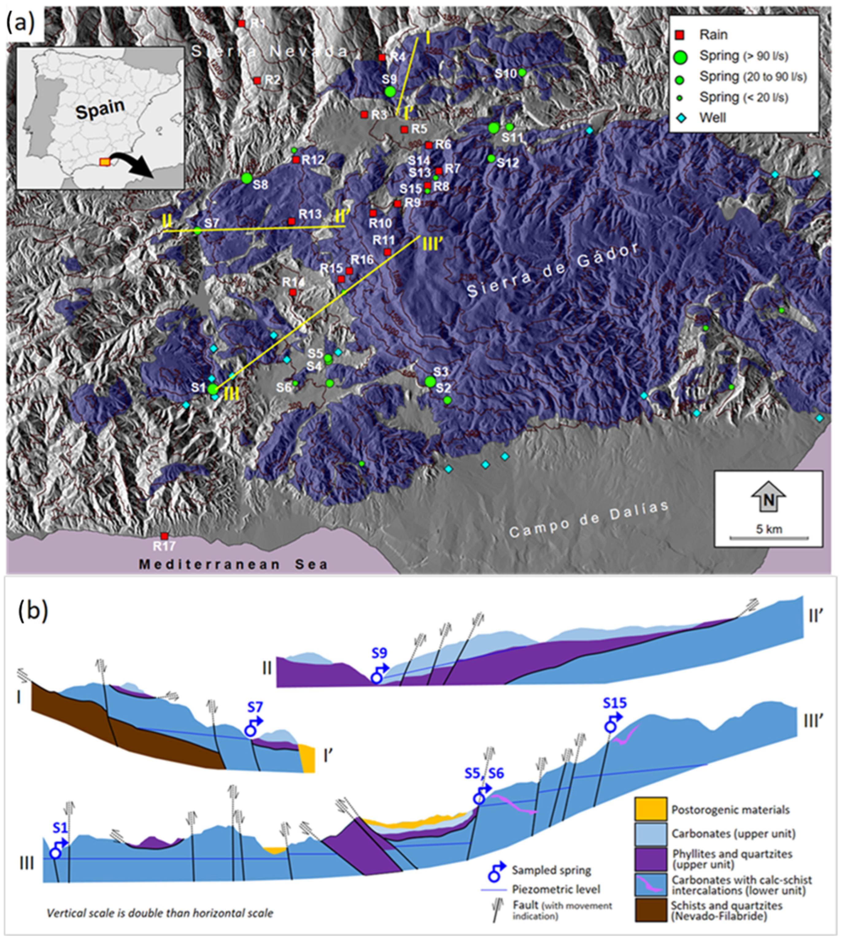
Sierra de Gádor is located in SE Spain, between the Mediterranean Sea and Sierra Nevada, the highest mountain range of the Iberian Peninsula (3479 m.a.s.l.). Sierra de Gádor is a morphostructural domain characterised by a complex and steep orography, with peaks over 2240 m.a.s.l. and just 18 km distant from the sea (
Figure 1). This coastal mountain range consists of thick series (originally > 1000 m) of permeable Triassic carbonate rocks that underwent heavy fracturation and dissolution processes, interspersed levels of low-permeability calcschists and an underlying level of impermeable phyllites of Permian age. The region is strongly affected by thrust tectonics. The whole structure was subject to large tensional and strike–slip fractures that enabled the development of basins filled with Neogene and Quaternary detrital deposits [
10] that appear like a fringe in the coastal plain known as Campo de Dalías (330 km
2).
The outcrops of carbonate materials occupy an area of approximately 900 km2, including Sierra de Gádor and adjacent sectors. Such carbonate outcrops are the main recharge areas for several hydrogeological systems with marked vertical and horizontal compartmentalisation, groundwater of different chemical characteristics and, in certain sectors, thermal phenomena.
The macroaquifer of Sierra de Gádor, which is of great complexity, is constituted by a large number of subsystems of different sizes and behaviours, some superimposed and others perched, with highly variable residence times. In general, two types of systems can be differentiated: (i) upper/perched hydrogeological systems that are located at high altitudes and are naturally drained through springs, and (ii) large and very deep systems with slow flows, long flow paths and sometimes evidence of hydrothermalism, which are exploited through deep boreholes. The former aquifers have shorter residence times, which have been estimated at 30–40 years through isotopic techniques [
11,
12,
13], whereas the latter are characterised by residence times of 2000–8000 years, according to [
13].
The climate of the study area is characterised by the marked spatiotemporal irregularity of the rainfall and strong altitudinal gradients in the annual precipitation and temperature. Whereas the coastal zone has a semiarid climate with annual precipitation below 275 mm, mean temperatures around 18.5 °C and an average of 35 rainy days per year, the mountain range summits record more than 750 mm/year and average temperatures of 9 °C [
14]. In this context, the altitudes of the carbonate outcrops are of exceptional importance in terms of aquifer recharge.
Owing to the natural scarcity of surface water in southeastern Spain, the hydrogeological systems of Sierra de Gádor and Campo de Dalías constitute resources of strategic importance. The exploitation of these aquifers is the backbone of the local economy, supporting the intensive irrigated agriculture of the area (one of the most productive in the whole country) and meeting the growing water demands from tourism. This severe water deficit has been pointed out by authors such as those of [
15], who reported the existence of around 1200 boreholes (some exceeding 1000 m depth) in Campo de Dalías, an annual water withdrawal of 130 hm
3 in 1998 and an annual recharge estimated at 48–54 hm
3, mainly coming from the outcrops of carbonate materials. More recently, the Hydrological Planning documents of the Mediterranean Basins of Andalusia for the period 2022–2027, estimated groundwater withdrawals of 155 hm
3/year in the Campo de Dalías–Sierra de Gádor sector, while the exploitable resources are 97 hm
3/year. Such a situation implies an overexploitation of 58 hm
3/year [
16].
1.2. Background: Previous Isotopic Studies in Sierra de Gádor
The great hydrogeological complexity of Sierra de Gádor and its adjacent area, together with the interest in achieving better assessment and management of its water resources, fostered the early application of isotopic techniques in the region. The first works on stable-isotope analysis in the study area were conducted by the authors of [
17], who proved the potential of these tools for unveiling the hydrogeological functioning of these carbonate systems. Later, the authors of Ref. [
18] conducted extensive groundwater sampling campaigns in Sierra de Gádor and, further west, in the Sierra de Lújar range, identifying different underground flow systems and an altitudinal δ
18O gradient for the groundwater of 0.28‰ per 100 m using data from several springs with known recharge areas. Similarly, the authors of Ref. [
6] studied the isotopic contents of precipitation and groundwater in the southern sector of the Iberian Peninsula (including the study area), identifying a distinctive isotopic signature in the precipitation of Mediterranean origin and establishing an altitudinal δ
18O gradient of 0.30‰ per 100 m for a single rainfall event. Years later, the authors of Refs. [
14,
19] determined the average altitude of the recharge area of the main springs of Sierra de Gádor and identified a mixed influence of a Mediterranean and Atlantic nature on the groundwater recharge that was masked by sub-cloud evaporation phenomena. In addition, these authors detected a high correlation between the parameter d-excess and altitude both in the groundwater and rainwater (pseudo-altitude effect). Using isotopic data, the authors of Ref. [
20] concluded that the recharge of the aquifers of the southern slope of Sierra de Gádor has a predominantly Mediterranean origin. They found a reduced temporal variability in the isotopic content of the borehole water, and they also detected the occurrence of marine intrusion phenomena through the use of isotopic and hydrogeological techniques. Other works, such as [
21], focused on the isotopic contents of groundwater and runoff on the southern slopes of Sierra de Gádor, suggesting the existence of an isotopic differentiation between the shallow and deep groundwater linked to the origin of the recharge. In the first group, they include water from springs with mainly an Atlantic origin. The second group, which includes water from deep boreholes in the plain of Campo de Dalías, displays a Mediterranean origin linked to past extreme rainfall events. The authors of Ref. [
22] compared isotopic data from aquifers of Sierra de Gádor and Campo de Dalías with isotopic data from the Mediterranean Basin obtained from the Global Network for Isotopes in Precipitation (GNIP) and previous studies. They observed a certain extent of the relationship between the amount of precipitation and its origin, indicated by the excess of deuterium, and proposed that the heaviest rain episodes, which contribute to most of the recharge, were of Mediterranean origin. A review of previous works on the recharge in carbonate aquifers of mountainous areas in SE Spain that includes experiences developed using satellite data, isotopes and other tracers can be found in [
23]. In [
24], the isotopic composition of the precipitation and groundwater samples enabled the detection of three main recharge areas at different altitudes in the carbonate aquifer. Finally, the authors of Ref. [
13] conducted a hydrochemical and isotopic characterisation of the Sierra de Gádor aquifer macrosystem to identify the processes that lead to the chemical differentiation of its waters.
2. Methodology
Rainwater was collected for its hydrochemical and isotopic characterisation from a network of 20 sampling sites distributed throughout an altitudinal range between 23 and 1794 m.a.s.l. Each sampling site was equipped with a funnel-shaped rain gauge (collecting surface: 283.5 cm2) connected to a 2 L collecting bottle. The rain gauges were placed strategically within the study area with the bottles protected from solar radiation by shrubs, and they had a gadget to reduce evaporation. The devices were installed over a period of 9 days (11–20 October 2008). After this period, the rain samples were successfully recovered, except for two devices that were lost and a third rain gauge that appeared overturned with most of its contents spilled. A fourth rain gauge was empty due to the absence of rain. Therefore, a total of 16 samples were recovered. As will be mentioned in subsequent paragraphs, the remote sensing imagery from AEMET (Spanish Meteorological Agency) evidenced that only two rainfall events took place during the control period (concretely on 14 and 19 October) and that precipitation occurred under similar synoptic circumstances.
Within the framework of this research, groundwater was sampled at 15 springs in the summer of 2020. The isotopic information was complemented with additional historical data obtained by the authors of [
14,
20] in 1996 and 1997, respectively, at the same springs, other springs and boreholes. In summary, isotopic information is available from 23 springs and 20 boreholes, which amounts to a total of 170 samples. The locations of the sampling sites are presented in
Figure 1a.
Figure 1b presents the structure and arrangement of the hydrogeological materials along several sections.
The amount of precipitation at each site during the control period was calculated from the volumes collected with each sample, and the contents of stable water isotopes (δ18O and δ2H) and several anions (Cl−, SO42−, NO3−) were analysed in the laboratory. The electrical conductivity was also measured. The δ18O and δ2H compositions of the samples from 2008 were determined in the Stable Isotope Laboratory of the Autonomous University of Madrid using standard IRMS mass spectrometry techniques immediately upon collection.
In the case of the groundwater samples from 2020, the isotopic determinations were conducted at the Hydrogeology Centre of the University of Malaga (CEHIUMA) using laser spectrometry with CRDS technology (Cavity Ring Down Spectroscopy).
The isotopic content of the whole set of samples is expressed as parts per thousand (‰) deviations, as set by the internationally accepted standard VSMOW (Vienna Standard Mean Ocean Water) (Equation (1)):
where
Rsample and
RVSMOW are the isotopic ratios (δ
18O/δ
16O for oxygen-18 and δ
2H/δ
1H for deuterium) of the sample and the VSMOW, respectively. The analytical errors are estimated as 0.1‰ for δ
18O and 1‰ for δ
2H.
The parameter deuterium excess (d-excess) was calculated using the equation of Dansgaard [
4] (Equation (2)):
The d-excess parameter expresses the excess of deuterium compared to heavy oxygen isotopes (
18O) in a water sample. It reflects the kinetic fractionation that occurred during the water phase changes and the evaporation conditions underwent by a given vapor mass. Therefore, this parameter can be employed as a tracer of the moisture source of precipitation and regional climate conditions. The d-excess is the intercept of the Meteoric Water Line (MWL), defined by Craig [
25] as (Equation (3)):
According to this expression, precipitation along the Global Meteoric Water Line is characterised by a mean d-excess value of 10‰, whereas in closed basins subject to intense evaporation, such as the Mediterranean Sea, the rainfall can display d-excess values ~22‰.
Anion concentrations were determined through ion chromatography in the laboratories of the Faculty of Marine and Environmental Sciences of the University of Cádiz. The electrical conductivities of the samples were measured using potentiometric methods in the same facilities.
Additionally, remote sensing imagery was gathered from AEMET (Spanish Meteorological Agency) to analyse the atmospheric circulation and origin of the cloud masses that produced the rain events. Concretely, the products downloaded were as follows: (i) visible and infrared hourly images obtained from the Meteosat satellite, and (ii) terrestrial radar images at 30 min intervals to identify the occurrence of rain over the study area.
Lastly, the spatial distribution of the isotopic and hydrochemical values was analysed using the software gvSIG 2.2 considering different geographical variables, such as the altitude, orientation and distance to the sea.
3. Chemical and Isotopic Results
The chemical and isotopic compositions of the rainwater and the physiographical characteristics of each sampling point are displayed in
Table 1.
The sampling sites presented an average height of 1077.8 m.a.s.l. The lowest point was located in Adra at 23 m.a.s.l, and the highest was 1794 m.a.s.l. in the municipality of Fondón. The closest sampling point to the sea is just 100 m away from the coast, while the most distant is in the municipality of Bayárcal, 33.5 km distant from the sea. The average volume of precipitation gathered in the 15 rain gauges was 15.6 mm. The maximum volume collected, 18.8 mm, was recorded at one of the sampling sites in the northern sector of Sierra de Gádor. At one of the sampling points, the rain gauge was empty owing to the lack of precipitation.
The average δ18O content for the sample set was −6.11‰, with a minimum value of −7.81‰, a maximum of −3.52‰ and a standard deviation of 1.26‰. The average δ2H value for the sample set was −36.96‰, with a minimum of −46.82‰, a maximum of −22.39‰, and a standard deviation value of 7.55‰. The average value of the d-excess was 11.89‰, with a minimum of −0.12‰, a maximum of 16.77‰ and a standard deviation of 3.99‰. Except for sample R17, near the coast, these d-excess values are intermediate: between 10 for global precipitation (GMWL) and 22, typical of the Eastern Mediterranean. As for R17, this sample reflects intense evaporation processes and/or mixing with seawater due to wave action, as deduced from its value close to 0.
The hydrochemical characterisation of the samples included determinations of the conductivities and Cl−, SO42− and NO3−. The conductivities ranged between 32 and 165.7 µS/cm, with an average value of 71.6 µS/cm. The rainfall samples presented low chloride contents, with a mean value of 1.7 mg/L. The minimum content of chloride (0.8 mg/L) was recorded in two rain gauges located at more than 1000 m.a.s.l, whereas the maximum concentration (9.5 mg/L) was recorded in the sample R17, near the coast. The sulphate and nitrate contents were somewhat higher. The SO42− concentrations ranged between 3.3 and 11.6 mg/L, with an average value of 4.7 mg/L. In the case of NO3−, the samples showed an average concentration of 4.2 mg/L, a minimum of 2.6 mg/L and a maximum of 9.5 mg/L.
The chemical and isotopic compositions of the groundwater, along with some characteristics, such as the heights and average discharge flows of the sampled points, are shown in
Table 2.
The springs sampled in 2020 are located at altitudes between 1425 m.a.s.l. and 170 m.a.s.l., with an average altitude of 705 m.a.s.l. According to [
14], during the period in which the springs were barely influenced by pumping extractions, the set of springs had an annual volume of resources of about 56 hm
3/year, with average discharge flows between 1100 l/s and 4 l/s.
The groundwater samples from 2020 are noticeably more isotopically depleted than the rain: the average δ18O content for the sample set was −9.38‰, with a minimum value of −10.01‰, a maximum of −8.77‰ and a standard deviation of 0.44‰. The δ2H values for the set of samples ranged from −62.89‰ to −56.32‰, with a mean of −59.01‰ and a standard deviation of 2.39‰. The average value of the d-excess was 16.05‰, with a minimum of 13.54‰, a maximum of 17.41‰ and a standard deviation of 1.33‰.
Regarding the hydrochemical characteristics of the groundwater, the conductivity ranged between 229 and 2036 µS/cm, with an average value of 527 µS/cm. The groundwater samples displayed notably higher ionic concentrations than the precipitation due to evaporation phenomena during the infiltration phase, and especially due to the salt inputs from the lithology. The chloride presented values between 6 and 452 mg/L, with an average concentration of 42.3 mg/L. The sulphate concentrations ranged between 8 and 586 mg/L, with an average value of 97 mg/L.
4. Discussion
4.1. Rainfall Source and Sampled Rainy Events
The examination of the meteorological satellite imagery (visible and IR) reveals the existence of a low-pressure system over North Africa during the sampling period. This system generated a cyclonic circulation pattern (counterclockwise rotation) that transported cloud masses with a main S–N component from Morocco towards the South of the Iberian Peninsula across the Alboran Sea (the western sector of the Mediterranean Sea).
As the clouds moved, there was an exchange of water vapour with the Mediterranean Basin that led to an increase in the d-excess of the samples. This distinctive d-excess (between 15 and 20‰) has been reported in previous works on Western Mediterranean precipitation [
6,
8,
26], although it may be masked by subsequent fractionation processes related to sub-cloud evaporation, as will be discussed below. In general, the isotopic signature of the post-summer rainfall events indicates the significance of the Mediterranean as a moisture source for the study area. However, as is described in [
27], the aforementioned cyclonic systems can collect air masses from several directions, producing rain events with intermediate deuterium excess.
Figure 2 is included as an example of the satellite information analysed in this work. It corresponds to the sequence of Meteosat IR images during one of the rainy episodes sampled in the study period.
The meteorological radar records from the period in which the rain gauges were operative (9 days) evidence that precipitation took place in the study area as two events: the first one on 14 October, between 11:30 a.m. and 15:00 p.m., with an SW–NE direction, and the second one on 19 October, between 13:00 p.m. and 19:30 p.m., with an SSW–NNE direction, endorsing what is displayed in the satellite images.
Figure 3 shows the sequence of radar images of the rainfall event on 19 October at 60 min intervals. Such images were produced by AEMET using data from meteorological radar stations distributed throughout the Spanish territory and represent the reflectivity of the raindrops, which basically depends on the amount of precipitation (namely, the number and size of raindrops falling).
The previous analysis shows that the rain samples of this work integrate two rainy events under similar meteorological conditions, in which the cloud masses moved through or were generated in the Alboran Sea, displaying a distinctive isotopic signature.
4.2. Hydrochemical Composition of Rainfall
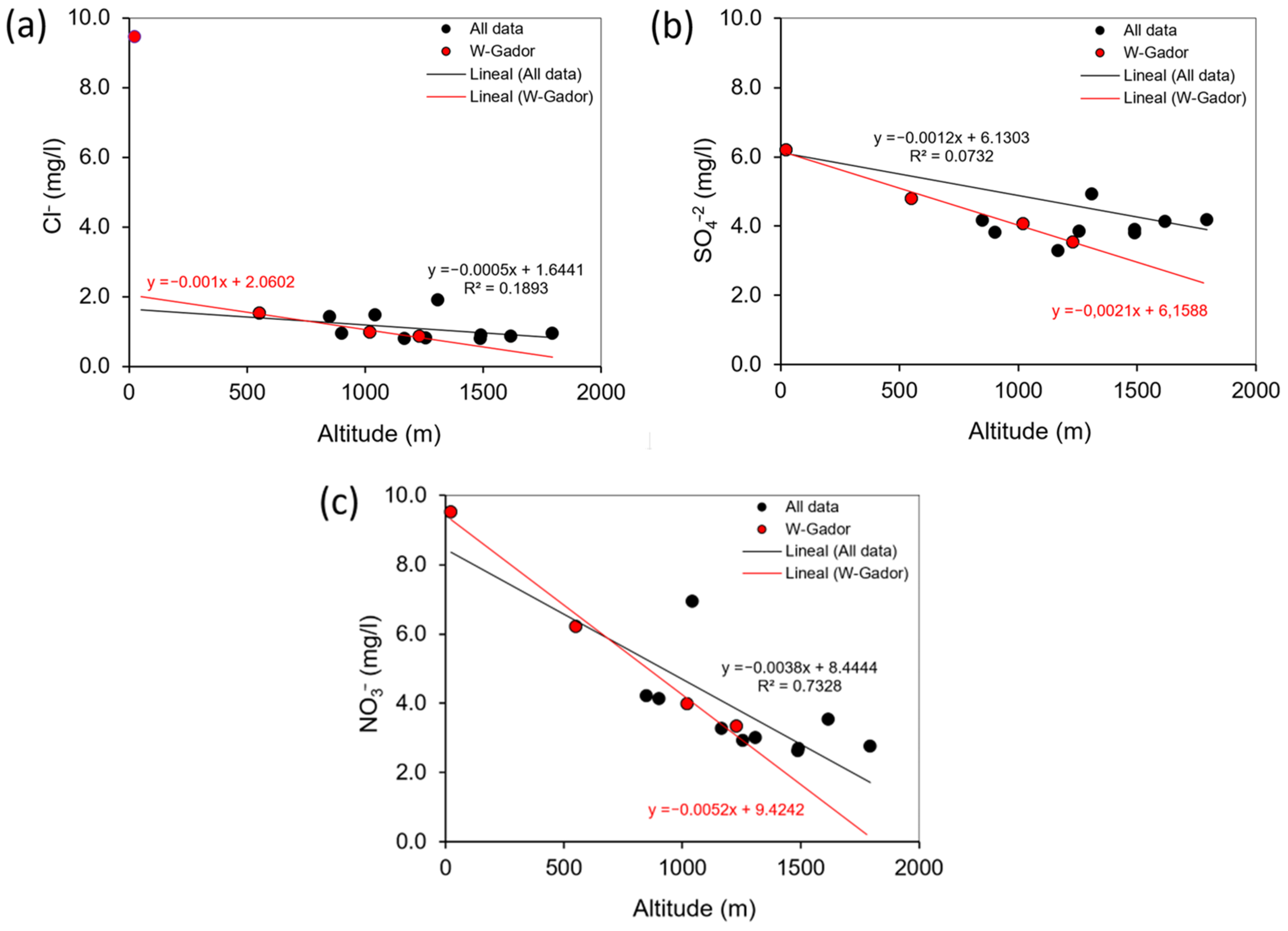
The spatial distribution of the hydrochemical results in the rain samples was analysed. The amounts of Cl
−, SO
42− and NO
3− in rainwater are to some extent dependent on the altitude of the sampling point, and the anion concentration tends to decrease with height. This effect is especially evident in the case of the rain samples from W Sierra de Gádor (
Figure 4). This is attributable to the fact that falling raindrops interact with atmospheric dust loaded with soluble salts, scavenging aerosols out of the atmosphere below the cloud base. Thus, the droplet–dust interaction will be greater as the distance from the cloud base to the ground surface increases, as occurs in lowland areas. Conversely, in the peaks and summits, this distance is shorter, and the rainwater incorporates less solutes. Furthermore, the bulk solute content in precipitation usually displays a decreasing gradient along a storm track and, therefore, with altitude, which might contribute to this phenomenon in the study area [
28,
29,
30].
However, when considering all the samples as a whole, the relationship between the anion concentration and altitude decreases notably, especially in the case of sulphate, for which the correlation with altitude is practically nil. This can be explained as the result of the disturbance induced by the rugged orography of the region in the airflow that transports clouds from the south. This effect implies a certain mixing of the air column caused by turbulence and affects the leeward slopes of the great topographic relief of Sierra de Gádor (the N slope of Sierra de Gádor and the S slope of Sierra Nevada). Nevertheless, on the W slope of Sierra de Gádor, the humid air masses are channelled towards the interior of the continent without significant disturbances, leading to a certain relationship between the altitude and anion concentration in this sector. This interpretation is consistent with the isotopic results described in
Section 4.3. In addition to the aforementioned processes, the concentration of sulphate may also be conditioned by the dust produced at several active or abandoned gypsum mines located on outcrops of evaporitic rocks, which are relatively abundant in the N sector of the study area. The presence of these exploitations can undoubtedly disrupt the correlation between sulphate and altitude, increasing the amount of this ion even at high locations. Regarding chloride, the sample located on the coast shows a sharp increase in the concentration of the ion owing to the influence of marine aerosols.
In summary, these results show the indisputable influence of the physiographic features of this coastal region on the hydrochemical characteristics of the precipitation, which is a critical aspect for the application of natural tracing methods. In particular, the application of the chloride balance method to estimate the recharge in the large carbonate aquifer would require a sufficiently dense rainfall-monitoring network with rain gauges at different altitudes over a period long enough to identify the average concentration of the tracer in the recharge water.
4.3. Isotopic Composition of Rainfall and Implications for Aquifer Recharge
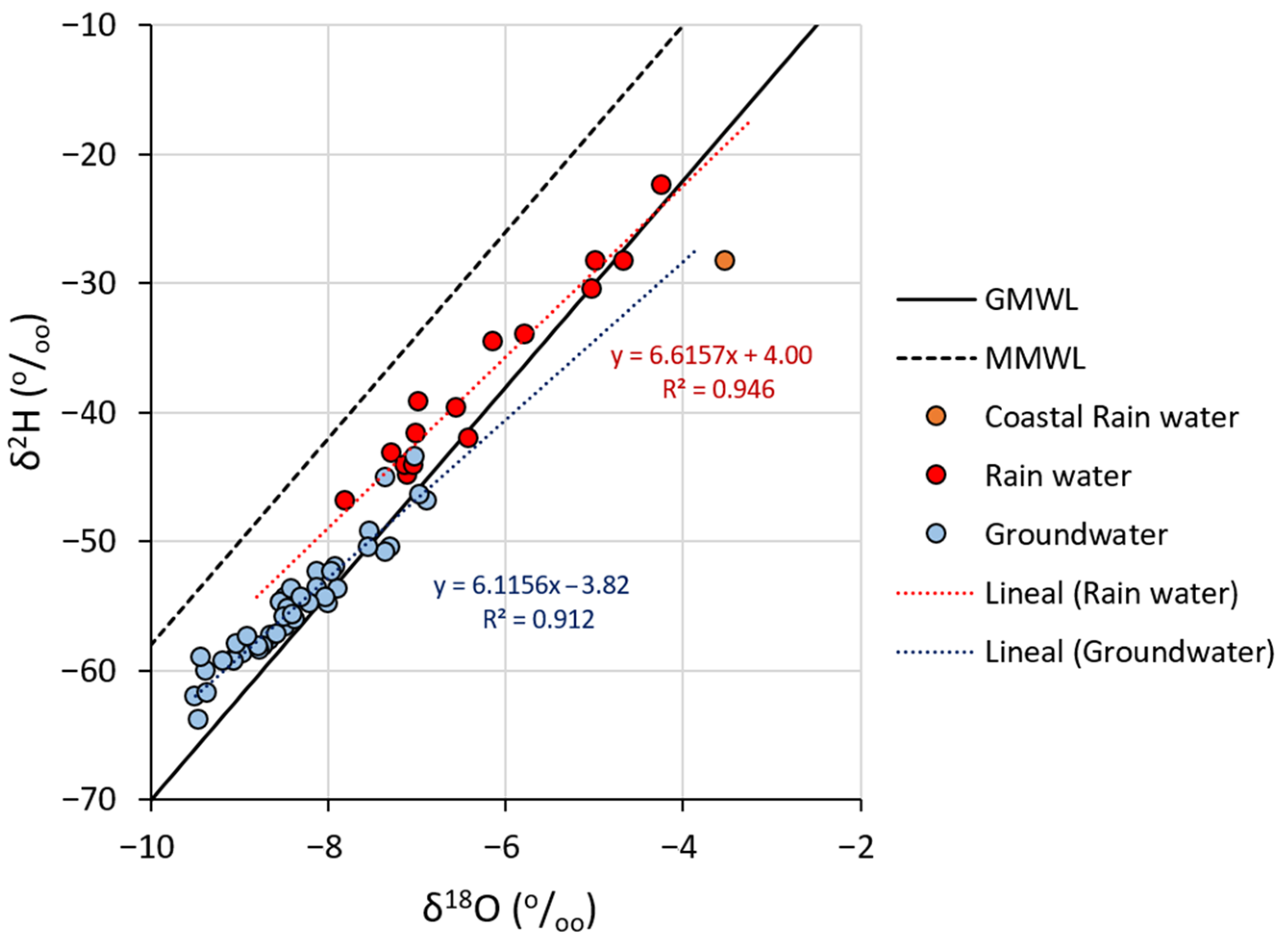
Figure 5 shows the relationship between the δ
2H and δ
18O contents of autumn rainwater (red) and the mean values for each groundwater sampling point (blue). Most points on the graph are located between the GMWL (Global Meteoric Water Line) and the MMWL (Mean Mediterranean Water Line). The rainwater and groundwater points appear to form two elongated clouds with a good fit with the corresponding regression line. The slopes are similar for both types of samples, 6.1 and 6.6, but they are noticeably lower than the GMWL and MMWL, for which the characteristic slopes are 8. Such differences in the slope conceal the Mediterranean origin of the rainfall and, likely, the Mediterranean influence on the groundwater recharge. In other words, the evaporative processes do not equally affect the water molecules containing δ
18O isotopes with respect to those with δ
2H. Evaporation leads to greater enrichment in δ
18O than in δ
2H, which results in the grouping of the samples in a line with a slope lower than 8.
The studied rainfall episode has a Mediterranean origin, as discussed in
Section 4.1. However, the rain samples collected at lower altitudes are located above the GMWL, and those from higher locations tend to be closer to the MMWL. This effect highlights the importance of the evaporative processes that take place after water condensates, while droplets fall from the cloud base to the ground surface. Evidently, the evaporative processes increase at higher temperatures and, therefore, at lower altitudes, coinciding with the most arid sectors.
The groundwater also displays such a trend; the less isotopically depleted samples are located over the GMWL, whereas those that are more depleted are closer to the MMWL. In the case of groundwater, additional evaporation may occur during the infiltration stage, in the first phases of soil wetting before deep percolation. The effect of partial evaporation prior to infiltration has also been reported in numerous studies in other semiarid areas [
31].
In addition,
Figure 5 shows that the groundwater is markedly more depleted in heavy isotopes than the autumn precipitation samples. This suggests that (i) the groundwater recharge in the study area takes place at high altitudes, and (ii) most of the aquifer recharge takes place during the colder periods (winter) rather than in autumn or during spring rain episodes, as has been demonstrated in several studies focused on other Andalusian karstic aquifers [
32,
33] and by previous research conducted by the authors of the present manuscript [
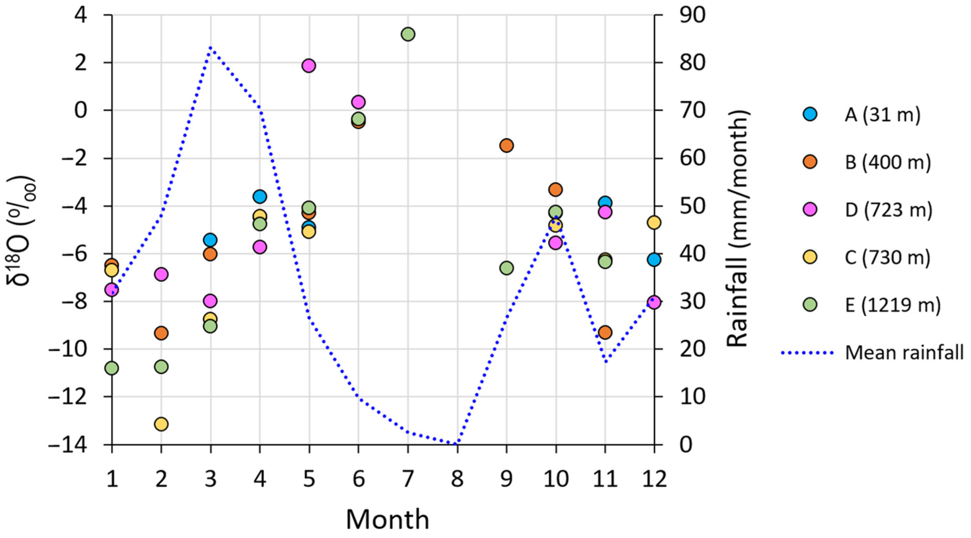
19]. Specifically, the hypothesis that the source of the groundwater replenishment is the rain from the coldest months is confirmed by
Figure 6, which displays the monthly oscillations in the δ
18O contents throughout the year at five rainfall sampling stations. As
Figure 6 shows, the δ
18O contents in the colder months (January and February) range between −13.1 and −6.5‰, whereas the isotopic values obtained in October range between −5.6 and −3.3‰.
Moreover, the influence of geographic factors on the isotopic content of rainfall was analysed in a GIS environment.
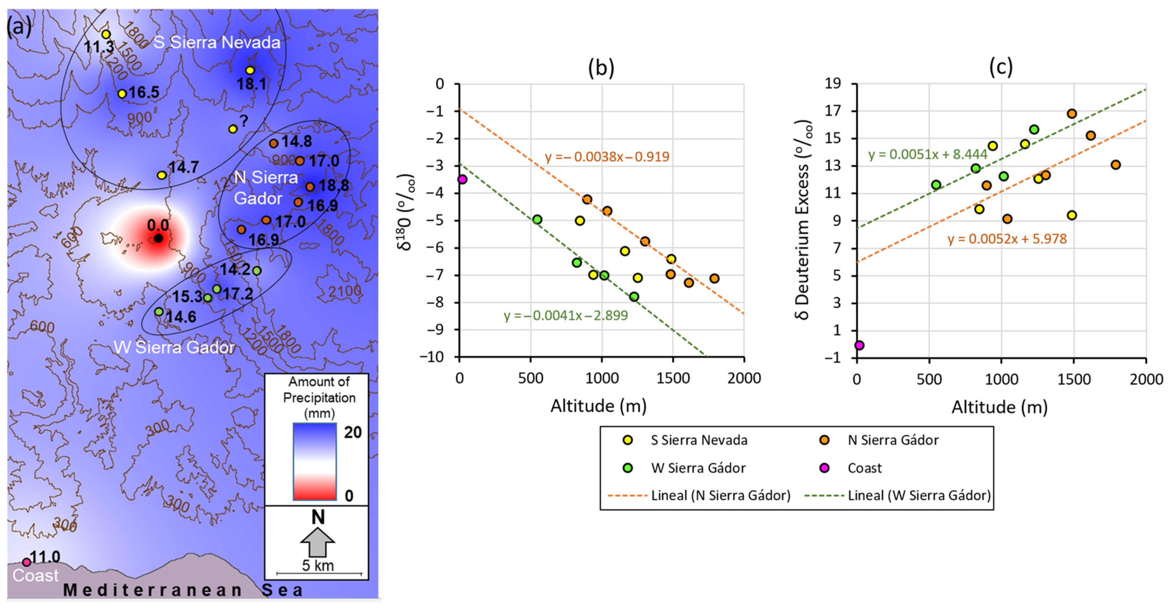
Figure 7a shows the amount of rain collected at each sampling point and the spatial distribution of the rainfall during the study period inferred from the application of the Inverse Distance Weighting (IDW). The absence of precipitation in the central sector is striking and must be attributed to the local orographic conditions.
Altitude is the factor with the greatest influence on the isotopic composition of the rain in the study area, which is in consonance with the findings of other studies in regions of complex orography [
34]. Concretely, the set of precipitation samples display a certain tendency towards δ
18O depletion as the altitude increases. This trend becomes more evident when the sampling points are grouped based on geographic location. For instance, in
Figure 7b, in which the samples appear grouped by location, there is an apparently good fit between the points and the regression lines of the samples from the western and northern slopes of Sierra de Gádor, both with similar slopes (0.40‰ per 100 m). Still, the samples from the western slope are more depleted in heavy isotopes owing to the condensation induced by the orographic lifting of humid air, whereas on the northern slope, the samples are less depleted.
The third group of samples, which were collected on the southern slope of Sierra Nevada, shows a worse fit, and the relationship between the isotopic content and altitude is less evident.
Figure 7c shows the relationship between the d-excess and altitude. Whereas the samples collected on the W slope of Sierra de Gádor show an acceptable adjustment and a d-excess increase of 5‰ per 1000 m of altitude, the samples from the N slope show a worse adjustment but a similar slope. Once again, the samples from the S slopes of Sierra Nevada do not seem to show a straightforward relationship between the two variables, which is attributed to the greater incidence of vertical turbulence produced by the orography. In any case, it should be mentioned that the number of available samples prevented us from performing a statistical significance test with the parameter R
2.
This seems to evidence that the orographic relief of Sierra de Gádor significantly alters the relationship between the altitude and the isotopic contents of the rain samples; when the cloud masses come from the south, the relationship between the isotopic content and altitude on the W slope of the mountain range (which is parallel to their trajectory) is unequivocal. Such a relationship, conditioned by the temperature gradient, does not only affect the δ18O content of rainwater but is also reflected in the altitudinal gradient of the d-excess. The latter is attributable to sub-cloud evaporation processes, which are more intense the greater the distance from the clouds to the ground and with higher temperatures. This implies that the distinctive Mediterranean isotopic signature in the precipitation is masked at low altitudes. On the leeward slope of Sierra de Gádor and the southern slope of Sierra Nevada, the occurrence of turbulence alters the isotopic proportions and makes it difficult to identify a clear relationship between the altitude and d-excess. A decrease in the d-excess parameter also occurs in this area, so that the rainwater loses its characteristic Mediterranean isotopic signature.
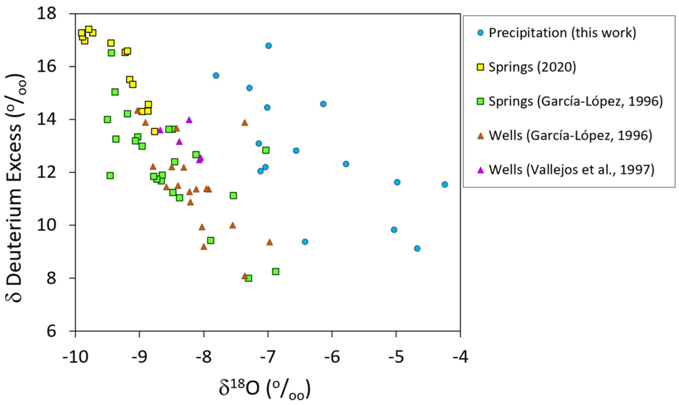
Finally,
Figure 8 presents the parameter d-excess against δ
18O for the rain and groundwater samples of the present study and those obtained from previous works [
14,
20]. It is noticeable that when both types of samples are less depleted in δ
18O, they present d-excess values around 10. If the effect of the previous evaporation of rain is not considered, it can lead to the erroneous interpretation that it has a predominantly Atlantic origin, or, in the case of groundwater, that the source of recharge is precipitation from Atlantic fronts. Nevertheless, the most isotopically depleted samples, which come from sectors at higher altitudes, present d-excess values greater than 15, which reveal a clearly Mediterranean influence.
In the past, this phenomenon has led to several interpretations that overlook the effect of sub-cloud evaporation described in the present study. Some authors [
21,
35] interpret that the source of the groundwater recharge has a different origin (Atlantic/Mediterranean) depending on the sector of the carbonate relief that constitutes the large aquifer. Other studies developed on detrital aquifers close to Sierra de Gádor [
36] consider that the primary origin of the groundwater recharge is the storms that come from the Atlantic Ocean, and that Mediterranean precipitation has a negligible role in the recharge. It has also been suggested that the isotopic signature of the groundwater in Sierra de Gádor is related to past extreme rainfall events [
21]. Still, the highly arid climate conditions (high temperature and low humidity in the atmosphere) of the study region favour such an isotopic differentiation between areas at different altitudes. Thus, in light of the findings presented in this work, the differences in the isotopic contents of the groundwater are greatly influenced by evaporation processes, which are greater at lower recharge areas and may conceal the importance of the recharge of Mediterranean origin. As for an ancient origin of the groundwater, considering the residence time and the exploitation rate to which the aquifer is subject, it is debatable whether the groundwater isotopic signature is related to past extreme rainfall events. The largest springs and deep wells located on the edge of the mountain range display very negative isotopic values because their recharge sources are located at high altitudes, where the effect of the sub-cloud evaporation on the rainfall is very small and, therefore, the Mediterranean character is not masked.
Finally, given the extremely inertial behaviour of the aquifer [
14] that stems from its characteristics (highly fissurated, internally compartmentalised, a very thick vadose zone) and confers on the discharge water considerable hydrochemical and isotopic stability, it is worth considering that the recharge associated with rainfall episodes of different origins (Mediterranean/Atlantic) becomes integrated within the system and leads to intermediate isotopic compositions. In this regard, the samples from the campaign carried out in 2020 appear more isotopically impoverished than those from historical records. This fact may be indicative of a modification of the climate, with an intensification of precipitation of Mediterranean origin to the detriment of that of Atlantic origin, which would imply a change in the recharge processes, the outcomes of which are difficult to forecast. Currently, the authors of this paper are working on this line of research and intensifying the sampling of these springs with the aim of verifying the existence of the aforementioned changes identified in 2020. These springs, due to their high compositional stability, could be considered witnesses of interannual changes in the medium and long term.
5. Conclusions
The present study, focused on the isotopic content of autumn precipitation, evidences the complexity of the spatial distribution of the rainfall’s isotopic signature and the magnitude of the orographic effect produced by the great coastal relief of Sierra de Gádor. Furthermore, the comparison of the characteristics of the rainwater with those of the groundwater enables further progress in the understanding of the sources of humidity and aquifer recharge processes. The most important conclusions drawn from this work are summarised below.
Firstly, the use of remote sensing products (satellite and terrestrial imagery) enabled us to identify the origin and trajectory of the cloud masses that produce precipitation and contextualise each rainfall event from a meteorological point of view. The precipitation events analysed within the framework of this study were linked to cloud masses that followed an S–N trajectory and that, according to their isotopic signature, underwent significant exchanges with vapour of Mediterranean origin. Nevertheless, sub-cloud evaporation alters these isotopic signatures and conceals their actual origin by reducing the parameter d-excess, particularly in the case of precipitation sampled at low and medium altitudes.
Secondly, the local relief in the study area has a twofold effect on the isotopic and hydrochemical characteristics of the precipitation. On the one hand, the isotopic content and hydrochemical composition display an evident relationship on the windward slopes with respect to the dominant atmospheric circulation. On the other hand, in the leeward sectors and especially on the southern slope of Sierra Nevada, this relationship vanishes owing to the atmospheric turbulences generated by the relief itself.
The groundwater shows a very stable isotopic composition, which is notably depleted compared to the rain sampled in autumn. This is attributable to the fact that the recharge of these aquifers occurs at very high altitudes, favoured by the morphology of the coastal relief and its high plateaus. In addition, most of the recharge is concentrated in the winter periods when the ambient temperatures are cold, especially at high altitudes, and the precipitation is very impoverished. Therefore, the recharge areas of the spring samples are located distant from the discharge areas, especially in the case of high-flow springs. This would justify the notable impoverishment of the groundwater sampled at such discharge points compared to the isotopic contents of the precipitation samples. In spite of this, the groundwater’s isotopic signature also evidences the occurrence of rainfall evaporation prior to infiltration.
Finally, a comparison between the average isotopic signatures from past groundwater samples and those from the present study reveals notable changes that suggest a change in the origin of the groundwater recharge and the increasing importance of the recharge of Mediterranean origin. Although this fact might be related to a change in precipitation patterns linked to global climate change, such a hypothesis requires further research. The authors are currently conducting new isotopic and hydrochemical sampling campaigns.


 ,
, 


