3. Tiwanaku Raised-Field Systems
The model of a typical raised-field structural configuration, as illustrated in
Figure 2, is based upon excavations of existing ancient berm structures, which revealed over ~1700 years of complex soil dynamics from Lake Titicaca water depth level excursions depositing lake sediments, rainfall flood erosion and sediment deposition, seismic ground slope distortions, later human farming activity, camelid pasturage disturbances, as well as later farming reclamation activity. As such, a computer model of the original raised-field berm construction design intent, as presented in
Figure 2, is based upon observed soil layer differences with different material compositions extracted from the excavation profiles [
23], together with estimates of layer thickness values. These estimates then form the material and geometric composition used in
Figure 2 ANSYS computer model.
The typical multi-layered raised-field structure has many interesting water and heat transfer characteristics. The soil moisture level of an agricultural berm originates from seepage of swale water into the saturated soil berm layer, absorption of rainwater and further from swale water transfer through capillary action into the agricultural berm soil. The constructed berm height over the saturated layer is determined by the root system structure of the specific crop type planted into the agricultural berm. The heat source for the agricultural berm derives from solar IR radiation, which is a function of time: during midday, the heat flux is at a maximum, while at night, heat is lost mainly through convection to night-time cold air. Additional heat transfer occurs due to a solar radiation trap provided by dark plant compost deposited onto the swale bottom; this design serves to trap solar radiative heat into swale water at temperatures well above the outside air temperature. This swale-sourced heat then provides additional heat transfer into the berm saturated soil layer (
Figure 2), as well as the main structure of the agricultural berm soil layer through both heat conduction and penetration of heated swale water through the porous soil layers. The moisture level of the upper berm planting zone (
Figure 2) influences the absorption level of radiative solar heating, the conduction heat transfer to the cold saturated groundwater aquifer and the heat transfer from heated swale water, which is further influenced by the thermal conductivity of the stone–pebble–clay insulation layer (
Figure 2). Heat losses derive from berm convective heat loss to the night-time cold air, internal berm heat transfer to the cold deep groundwater layer, as well as other thermal gradient heat transfer effects between the various layers in
Figure 2. All of these heat transfer effects play a role in maintaining trapped heat in the agricultural layers, as
Section 5 will later illustrate through the ANSYS heat transfer analysis.
The temperature history of the berm moist agricultural soil layer depends upon the variable time-dependent air temperature, which governs convective heat loss from both the agricultural layer and swale water, the intensity level of the solar IR flux during day and night times, and the moisture level change in the berm agricultural layer as sustained from day- to night-time soil temperature variations. For multi-cropping during wet and dry seasons to support the large urban population of Tiwanaku, the swale water depth is derived from excavation into the saturated groundwater aquifer, which must be maintained constant; this was accomplished through elaborate water supply and drainage channels in the raised-field areas, as well as through an elaborate moat system for agricultural fields and secular and elite occupation compounds within urban Tiwanaku [
41]. Clearly, ancient Tiwanaku water engineers designed many innovative water control and distribution features to maintain the continuity of their society, which correspond with modern-day hydraulic practice.
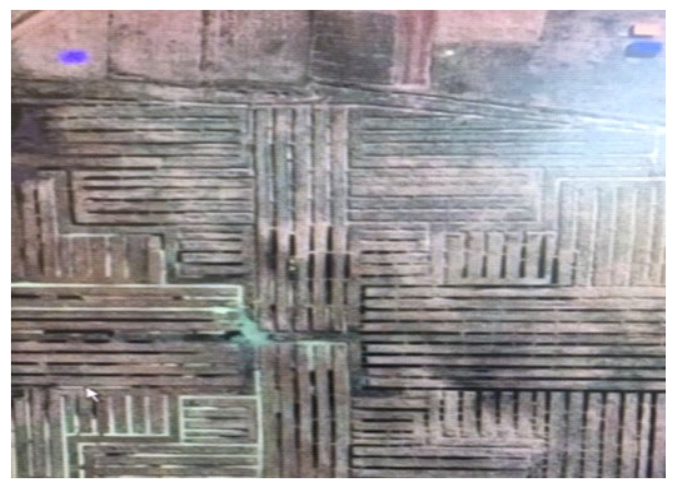
Raised-field designs incorporate different swale geometries encompassing agricultural berm groupings, as shown in
Figure 3 and
Figure 4 for recently reconstructed raised-field systems brought back into use within the past three decades by local communities living adjacent to the Pampa Koani field system area. Different berm groupings were created for different crop types with different berm widths and lengths; typically, the berm widths range from ~5 to 10 m, while the berm lengths range from ~10 to 40 m in reconstructed fields originating from the ancient field system’s configurations. Of interest is the optimum minimization of swale widths to maximize berm widths and lengths in order to maximize the agricultural productivity areas [
41].
The excavated raised-field profiles [
12] permitted inference of the original raised-field design intent. The excavated soil types in the top portion of the agricultural berm (
Figure 2) consist of brown loamy clay with gravel inclusions intermixed with carbonized plant fragments likely derived from burnt grass originating in post-harvest times. The saturated berm layer’s moisture level (
Figure 2) is mainly the result of immersion and infiltration of the swale water. The swale water depth (through excavation into the groundwater) is designed to accommodate the optimum moisture level for different plant root system types. Different thicknesses of the berm agricultural layer were created to further accommodate different plant root system types. The freshwater swale depth observed from excavation of the ancient raised fields is approximately ~1.0 m into the local groundwater aquifer. The bottom of the swales had a deposited layer of detrital decayed plant material, which served two purposes: (1) the excavated decayed plant material in swales was mixed into the berm agricultural layer to add mineral nutrients, particularly phosphates, to aid crop growth; (2) the remaining blackened compost detrital plant material in swale bottoms served as a black IR radiation trap to promote swale water heating. The base insulation layer (
Figure 2) represents a stone–pebble–clay aggregate likely designed to limit heat transfer from the upper layer soil and water into the colder lower groundwater aquifer (
Figure 2).
4. Modeling Raised-Field Agricultural Function: Introduction and Analysis
To gauge the kind of analysis required to understand the workings and efficiencies of raised-field systems designed by the Tiwanaku engineers, a number of factors need to be considered to understand the geophysical environment in which raised fields operate. These include (1) the salinization of raised fields through incursion of saline Lake Titicaca water and cases in which the Titicaca lake level temporarily exceeds the local fresh groundwater table height and/or the groundwater table recession due to drought conditions, leading to saline water intrusion affecting berm soil fertility; (2) drainage of freshwater saturated soils into raised-field swales when the lake level is below the local groundwater table height, which thus dries berm soils, limiting agricultural production; (3) agricultural land area, which depends upon Titicaca lake level (given that the ground slope of lakeside land is shallow, a rise in lake level can extensively flood and reduce agricultural land area); (4) changes in the heat storage capacity of a raised-field system due to surface sediment deposits from erosive rainfall runoff and lake height coverage sediment deposits; (5) agricultural berm soil fertility change resulting from rainfall flood conditions, producing nutrient leaching and monocultural cropping, whose post-harvest waste comprising compost matter lacks critical mineral nutrients when remixed into berm soils. Many of these effects depend upon the variability of Lake Titicaca water level, which is influenced by rainfall levels and drought events.
The relation between these five effects and the lake level, denoted as h
1, as measured from a given reference plane, is shown in
Figure 5 in schematic form. In this figure, h
MN < h
MX, where h
MN and h
MX represent minimum and maximum possible Lake Titicaca levels. The h
MN value represents an extended drought period lake level, while the h
MX value represents a maximum flood lake level. The ‘normal’ lake level h height fluctuation range is defined to be h
N2 < h < h
N1, involving rainfall amounts between h
N2 and h
N1, which represent the normal seasonal lake level variation.
Other lake level fluctuations may occur due to long- or short-term climate cycles, involving varying rainfall amounts into the altiplano drainage or watershed zone, which channels groundwater and runoff into the lake. As the lake level increases, salinization, which is a function of (h
2–h
1), also increases (
Figure 5). This reflects the fact that saturation by any means other than fresh groundwater increases as (h
2–h
1) decreases. The quantity h
2 is defined to be the groundwater average height above a reference plane. Similarly, drainage of groundwater varies with (h–h
1), as the higher the groundwater level with respect to the lake level, the greater the drainage capability of preserving agriculture in the raised fields. This factor greatly affects the initiation and completion time of the growing season. The arrival of the maximum groundwater flow to the field systems near the lake edge occurs past the peak of the rainy season. This is due to the generally low flow percolation speeds of groundwater deposited at remote low slope eastern locations within the collection basin of the lake added to local rainfall absorption into berm soils. The local low ground permeability constants and low aquifer pressure gradients are then the source of the continuous arrival of groundwater from multiple sources to the lake edge, including significant groundwater flows in the dry season. Thus, the swales can serve as channels to help drain the berm ridges in dry as well as wet months when h
2 > h
1. The swales present drainage paths for saturated soils in the berms during heavy rainfall periods, as well as for the field system area away from the lake edge during lake height excursions. Water may then flow into the swales and to the lake, provided h
2 > h
1, in addition to water, flows through the aquifer to the lake. Aquifer water flowing downslope to the lake is derived from rainfall interception and rainfall absorption into the higher elevation plains far to the east of the Pampa Koani raised-field area. The distant aquifer flow source originates from centuries of past rainfall events into the elevated plains east of Pampa Koani, providing aquifer water to the lower level lake; when the lake level is high, the aquifer backup raises the groundwater level, requiring swale drainage to the lower level field areas. Due to heavy rainfall periods raising the lake height, which limits aquifer drainage into the lake, agricultural land areas can be inundated, resulting in the transfer of farming activities to higher level raised fields distant from the lake edge. Examination of the totality of the Pampa Koani field system area reveals additional substantial non-farmed areas reserved for agricultural production during high level lake height excursions. We previously noted [
14,
15,
30,
41] that a channel originated in the eastern part of the Tiwanaku River, which possessed an elevated drainage port from the channel bottom. Excessive rainfall collected into the river from higher elevation surface runoff then delivers water into the channel; as the river height increases from excessive rainfall runoff and delivers water into the channel, the elevated channel sidewall drainage port transfers excessive water into Lake Titicaca through an auxiliary channel to prevent excessive water entering the raised-field area to increase the groundwater elevation. When the dry season begins, the channel transfers the available water (maintained below the channel sidewall drainage port) to the raised fields to help sustain the groundwater elevation in the raised-field area to maintain the proper swale water height. Thus, the Pampa Koani raised-field groundwater level is simultaneously affected by lake height change, local rainfall infiltration, rainfall surface runoff, groundwater transfer from elevated areas east of the raised fields and the river-supplied channel with its elevated drainage port, as described above.
The land area available for agriculture is likewise dependent upon the lake height, as previously mentioned. In cases where raised-field berms protrude above the lake level for near-shoreline agriculture, and h
1 is approximately equal to h
2, then, artificial mounding and/or buried impervious clay layers found in the field systems may be used to regulate the berm surface height to water table height distance to protect root systems from waterlogging. This effect may be an additional reason beyond heat transfer effects for the presence of the insulation layer (
Figure 2) to limit groundwater height excursions into berm agricultural zones and distribute water into the swales for rapid transfer to the lake.
Figure 5 presents a summary of the lake level and climate variation effects on the survivability of raised-field agriculture in terms of the previously discussed lake height variables. For h
MX, severe flooding terminates all nearby lake field system agriculture (G,
Figure 5). For h
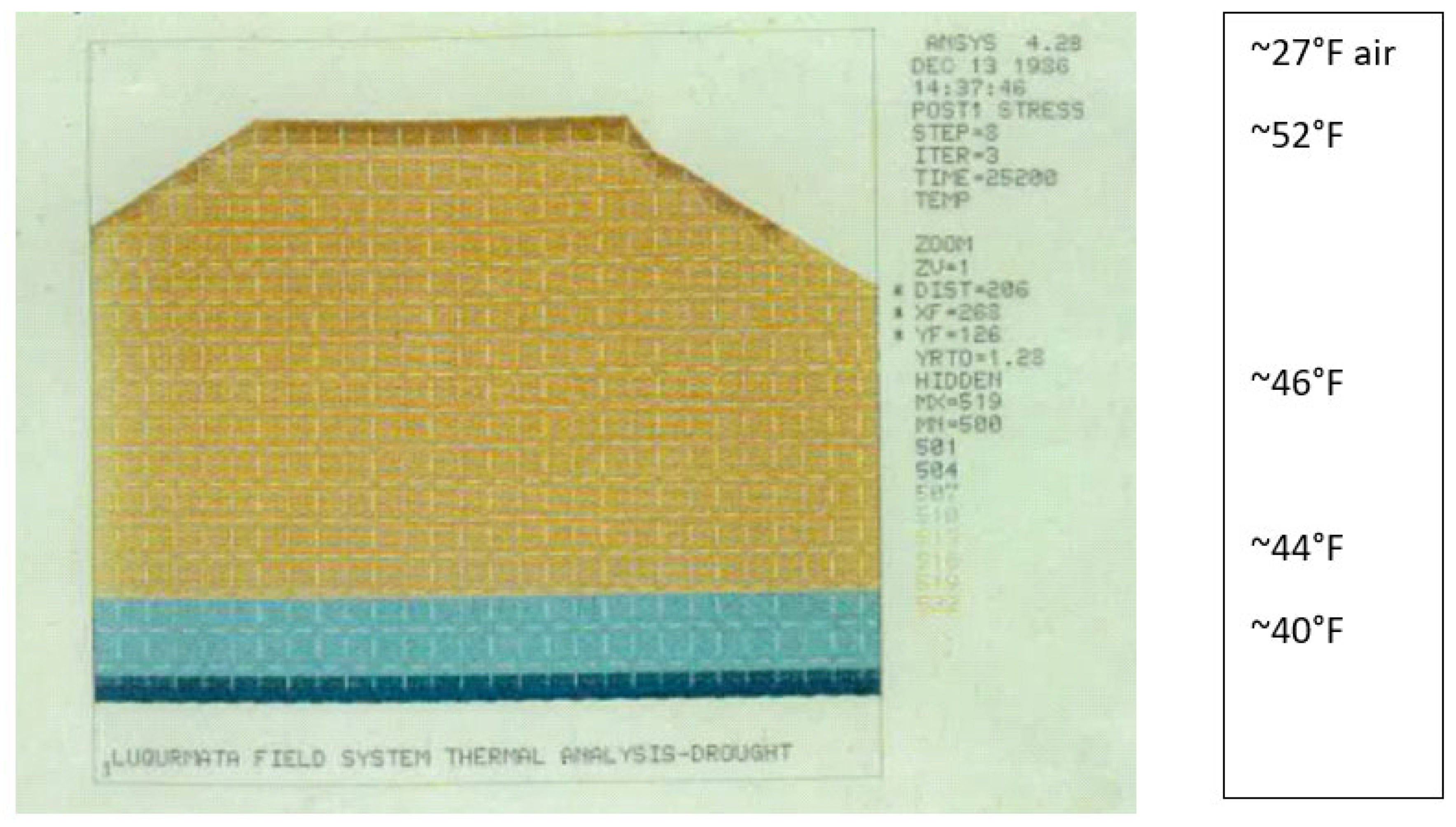
MN, severe drought (
Figure 2) likewise cancels all agriculture, as swales contain no water due to groundwater recession. Within the h
N1 < h < h
H2 limits, agriculture can be sustained. Likewise, salinization from excessive lake height h > h
N1 limits agriculture for many vital crop types. The available agricultural land area is likewise limited for lake heights above h
N1. Field system swale drainage of excessive water from rainfall events raising the local water table occurs when the lake height is between h
N2 and h
MN, or lower heights, as indicated in
Figure 5.
As analyzed in
Section 5, heat storage within agricultural berms largely depends on the berm’s capacity to store solar IR radiation; in turn, this heat storage capacity depends upon the berm’s soil/water moisture level’s high specific heat value in order to retain heat over long time periods, given the heat losses due to convection into cold night air and conductive heat losses to the cold water deep aquifer limited by the insulation layer shown in
Figure 2. The berm soil specific heat value depends upon the moisture level in the berm soil composition [
43]; this level depends upon capillary infiltration from swale water, residual water absorption from previous rainfall events and capillary water transfer from the deep groundwater aquifer, which is likely reduced by the intended high clay content composition of the insulation layer shown in
Figure 2. Evaporative heat loss from warm moist berm soils to lower temperature air requires heat input to convert water to water vapor; this heat comes from higher temperature heat residing within the berm interior. Additionally, high temperature heat may be conducted and convected to the surrounding lower temperature air.
The sum total of these effects results in the geometry of an optimum farming productivity survivability polygon (
Figure 5), whose boundary points reflect the limitations and advantages derived from various constraints, denoted as HS
M′-S
M′-D
M′-A
M′-S
M-HS
M-A
M-D
M. Outside of this polygon, lake height field system flooding with induced salinization, berm soil heat storage capacity change due to moisture level, high and low air temperature excursions, excessive different temperature surface winds affecting heat transfer, excessive cloudiness limiting solar IR radiation, lack of available farming land area, soil fertility, field system drainage and drought effects, can combine, singly or in unison, to severely limit agricultural productivity.
5. Thermal Analysis of Raised-Field Agricultural Systems
Field system heat storage capability depends upon the transient saturation state of raised-field soils, as determined by different heat input and heat loss terms. Heat storage from the solar IR flux (
Figure 2) plays a major role in modulating diurnal ground temperature. As the soil saturation increases as a function of groundwater height (h) with respect to the raised-field system berm surface, the heat storage capability of the moist soil increases. Clearly, there is an ideal moisture level in berm growing areas, which best retains solar-sourced heat and is optimal for different crop types’ growth and survival under extreme freezing events and which underlies the raised-field system design intent shown in
Figure 2.
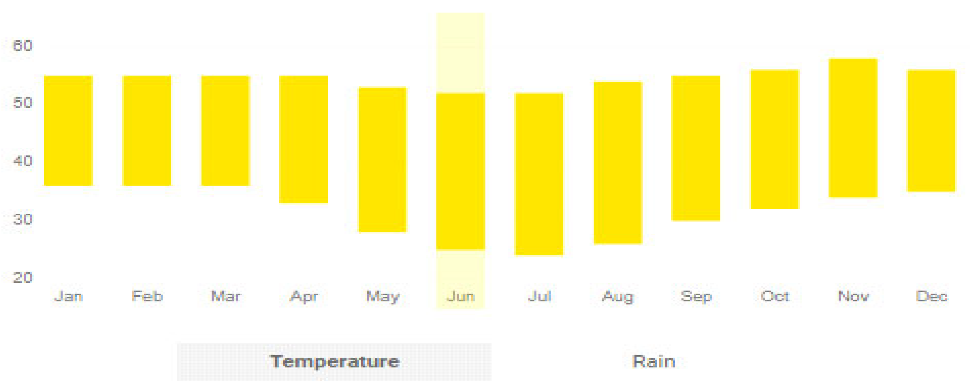
Expansion of the heat storage capability enhances the survival of crops during cold altiplano nights and determines the effective end of the growing season, as the heat storage effects limit ground freezing and the resultant destruction of root crops. Typically, Bolivian altiplano temperatures below freezing occur from May to September (
Figure 6), with October to April defining the main growing season; several subsurface tuber crops (potatoes, oca, ulluco, mashua), along with high-altitude adapted surface crops (maize, quinoa, cañiwa), which can survive year-round cold temperatures, were selected by Tiwanaku farmers in order to maintain food supply sustenance for the city’s large population. The addition of imports from Tiwanaku satellite settlements devoted to cultivating temperate and subtropical crops at lower elevations contributed to sustainable provisioning of the Tiwanaku urban center. Given the annual monthly range of temperatures experienced at the altiplano (
Figure 6), clearly, little is left to chance in the provision of food resources through adoption of technologies inherent in the raised-field system design (
Figure 2) operating within the survivability polygon shown in
Figure 5.
The current altiplano temperature ranges shown in
Figure 6 may reflect those of ancient Tiwanaku, as the site’s flourishing from c. 500 to 1100 CE reflects successful operation within the survivability polygon. An exception to this period of sustained agricultural activity occurred in the c. 1000–1100 CE time period as a result of significant climate changes of extended drought and consequent agricultural land reduction [
23,
26,
28,
44], resulting in the collapse of Tiwanaku economic and political structures, as indicated in line E in
Figure 5.
Other authors [
39,
40,
45,
46] emphasize air temperature and humidity effects, as well as air currents over raised fields, as influencing crop survival. Based on years of personal on-site experience in the Pampa Koani raised-field area during winter months, it is noted that a temperature inversion layer can occur in wintertime—this being observed from smoke from a surface fire seen rising, then ‘flattening out’ horizontally above the raised-field surface at approximately ~100–200 m altitude. This observation indicates a lack of substantial surface winds to disturb the rising smoke column from reaching the inversion layer interface. This observed effect, which serves to trap cold air close to the land surface, is indicative of the many localized weather effects, which may influence air temperature over raised fields. Given the extensive periods of being on-site in wintertime and observing the lack of strong wintertime surface winds, nevertheless, cold air carrying winds over raised fields may occur under special conditions to further increase berm heat transfer to refreshed cold air when this event occurs.
In terms of the humidity effects affecting heat transfer into cold air, air thermal conductivity decreases with increased moisture content, thus limiting conductive heat loss to the atmosphere from the solar-radiation-heated moist berm surface. A further internal heat source results from the decomposition of plant remains mixed into berm soils; although contributory to internal berm heat storage, this is a time-localized effect of somewhat lesser importance compared to the daily solar heat input effects affecting berm heat storage. Although there may be instances where temperature and humidity extremes outside of the mean values used to generate
Figure 6 apply (for example, during extreme drought or heavy rainfall periods), the ANSYS analysis presented is intended as a quantitative demonstration—based upon average thermophysical properties and field-observed conditions—to show the origin of the internal berm heat storage effect vital to the preservation of wintertime crops important to Tiwanaku’s continuity over many centuries.
The degree to which all parameters are effective in the survivability polygon depends additionally on soil fertility, which had seasonally increased in post-harvest times; this increase occurred by churning decomposed plant debris into the berm topsoil. As soil fertility and nutrient composition decline from continuous use over the years, crop viability due to salinization, waterlogging and decreased heat storage capacity will be affected. With respect to
Figure 5, if the normal lake height fluctuation is h
N1 < h < h
N2, then the polygon area A–B–C–D bounds the normal operating range of the four parameters shown (heat storage, salinization, farming area, drainage). Operation within A–B–C–D therefore ensures stable agricultural production. If the lake level h
1 approaches a high maximum level h
EX1, then high salinization, low land area for farming and low drainage considerations apply. Although high heat storage can result in field systems under these conditions, the waterlogging of these fields only leads to crops grown with shallow root systems, which are likely prone to destruction through freezing. This effect occurs, as shallow root systems do not deeply penetrate the water table but rather spread out in the berm topsoil region, making them vulnerable to frost destruction, as no nocturnal stored internal berm heat is retained to protect shallow root crop types. Waterlogging of shallow root systems creates biological conditions unfavorable to crop maturation, leading to decreases in crop yields. At low lake levels h
EX2, low heat storage prevails, while good drainage and low salinization accompany agriculture in a large exposed agricultural land area.
To a certain degree, the reduction in salinization and incursion of lake-borne concentrates from lake height excursions, as well as increases in berm internal heat storage, can be obtained through swale infilling and elevation of the planting berm surface; these changes alter the distance from plant roots to the water table surface and swale depth. This control can be exercised if fill is available for transport or is simply built in the original berm design (
Figure 2) based upon the anticipated lake level fluctuations. Observations of field plots in the Pampa Koani and Pajchiri areas [
13,
19,
25] indicate that this strategy was inherent to the raised-field structure (
Figure 2) and was actively pursued for the production of crop types vital for sustenance of the Tiwanaku population over many centuries.
To examine the heat storage effect related to heat conduction transfer times in moist berm soil mixtures depending on soil thermal diffusivity κ, the well-known transient heat conduction equation is delineated:
where ρ = density (lb/ft
3)
T = temperature (°F),
c = specific heat (BTU/hr lb °F),
t = time (hr),
k = thermal conductivity (BTU/hr ft °F),
and κ = thermal diffusivity (ft2/hr).
Air = 0.187,
Rock = 0.0188,
Soil (Av) = 0.0046,
Soil (sandy, dry) = 0.0028,
Soil (sandy, moist) = 0.0033,
Soil (soil mix, moist) = 0.0040,
Water = 0.0014.
A solution to Equation (1) is
For a berm soil block at T = 0 at t = 0 for 0 < x < ∞ depth range with a given κ value, where the x = 0 top boundary is maintained at T0 > T, the heat conduction solution gives the ensuing T (x, t) in the berm soil block for t ≥ 0, 0 < x < ∞. From Equation (2), for a location x1 where T = T0/2, the time for this heat transfer to produce this effect is given by t = κ−1 [x1/2 (0.477)]2, using the standard error function reference (Abramowitz and Stegun 1964). The smaller the κ value, the longer the time for heat transfer to progress. The mechanism for temperature progression is the continuous heat flow from the berm block from the constant temperature T0 boundary at x = 0. From this solution, the time for a temperature reduction to T0/2 at x1 depends inversely on thermal diffusivity κ. From the above table of κ values for different media, it is noted that when the medium of heat conduction is air, then cooling at a depth x1 to T0/2 occurs rapidly owing to κ being large for air, so that the time to cool to T0/2 is a small value. If the berm soil medium for heat conduction is wet or substantially moist, then the time to cool at x1 is considerably larger. If the medium is water, then the time to cool to T0/2 is approximately 133 times more than if the medium is air. Thus, the lower the κ value, the greater the heat storage effect.
Based upon these observations, given the soil medium characteristic of raised fields, if heat can be absorbed internally by means of daily solar flux input, then the possibility for heat retention during cold altiplano nights is high, as the time required for heated moist berm soil to cool is low due to its small κ value. The heat retention capability then acts as a further protective enhancement to protect root crops against altiplano temperatures, which would ordinarily destroy crops through freezing. The presence of water in the raised-field systems’ swales further enhances the heat storage capacity of the system, as swale water’s dark base of decomposed plant debris provides a radiation trap, producing elevated water temperatures. As water’s κ value is low, it will retain heat for extended periods, and this serves as a supplemental heat source to the berm interior during long cold nights. Through these means, an extension of the growing season may be achieved by possibly a few weeks, enabling double cropping of certain types of products or at least survival of existing crops to a further level of maturity, as was demonstrated empirically by contemporary farmers on rehabilitated raised fields [
24].
In order to study the heat retention effect, an ANSYS experimental heat transfer model [
43], utilizing the berm model from
Figure 2, is created to closely represent actual Pampa Koani and Lukermata raised-field system’s heat transfer and heat storage capabilities [
27], as determined from ancient excavated raised-field sections. The analysis includes berm and aquifer thermal and physical properties, swale water thermal and physical properties, and it includes daily solar IR flux values as a function of the month with reference to the coldest months shown in
Figure 7.
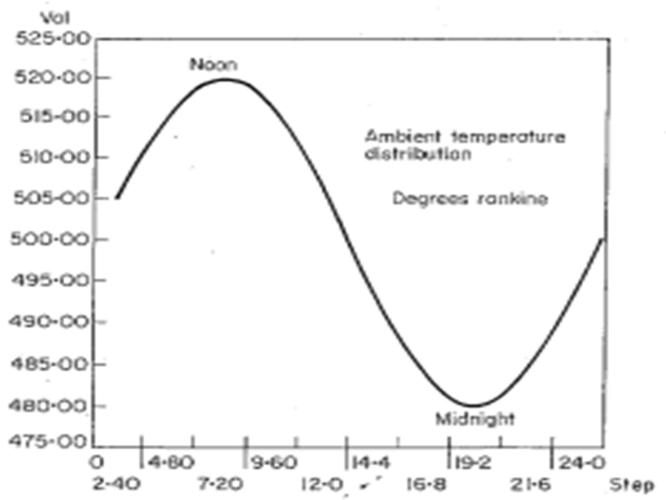
Figure 8 shows representative air temperature values during this same time period.
Figure 7 lower scale represents the month values; the upper scale represents the daily time values. Note that winter days are short in the southern hemisphere (as in the northern hemisphere). The 4–12-month period shown in
Figure 6 is traditionally considered by local farmers in the Tiwanaku altiplano area as the ‘winter months’, as low and freezing temperatures continue to challenge crop survival for many months at the high altiplano elevation.
Figure 7 scale represents a time period from ~5 am to ~6 pm, with a midday peak solar heat flux time in the early afternoon. After 6 pm, no solar flux exists during night-time hours. The temperatures in
Figure 9,
Figure 10,
Figure 11,
Figure 12 and
Figure 13 are given in degrees Rankine, translatable to degrees Fahrenheit as °F = °R − 459.67.
Figure 8 represents the diurnal air temperature variation from ~5 am to ~6 pm, with a maximum value around noontime and a minimum value at midnight, with temperatures given in degrees Rankine. The local air temperature serves as a heat source (or heat sink) for altering the berm surface temperature and soil structure below the berm surface, as shown in
Figure 2. Heat may be gained or lost through convective and conductive heat transfer from or to the solar heated IR radiated berm surface to the surrounding air to alter the heat content and temperature of the berm surface and interior berm layers shown in
Figure 2.
In all ANSYS finite element calculations, heat transfer through conduction, convection and solar IR radiation is accounted for, given the estimated material properties of berm soil material components, swale water and the surrounding air. The raised fields are considered as two-dimensional media divided into saturated aquifer soils below the water height in the swales and soils above the swale water level, which are in the phreatic and vadose zones [
43]—that is, soils, which have a lower water moisture content than fully saturated soils. These phreatic and vadose soils obtain their moisture through capillary action from subsurface groundwater, capillary transfer from swale water and rainfall absorption. The surrounding air, as well as the clay–stone–pebble insulation layer (
Figure 2), are also included in the ANSYS heat transfer model, together with its estimated density, heat capacity and thermal diffusivity properties. Heat flux input is delivered through solar IR radiation into surface berm soil material, as well as into swale water. Transient heat conduction occurs throughout the various soil types, the ambient air and the water contained in the swales. The English unit system is converted to consistent values, and it is used as input values in subsequent ANSYS heat transfer calculations. Surface heat transfer coefficients for free convection, as well as radiation and reradiation emissivities and the related constants, are again estimated [
43]. The required numerical calculations supporting input data follow from standard references. Because the solar flux varies on an hourly basis (
Figure 7) in a 24 h cycle, an ANSYS cosine distribution model of the input flux is created; similarly, the input values for air, water and berm and aquifer moist and saturated soil properties are given [
24], as estimated for the winter months in
Figure 6.
The finite element method for heat transfer problems starts with the Poisson equation, with temperature as the dependent variable [
6]. This equation in the matrix form is as follows:
where:
[c] = specific heat matrix, including the appropriate mass effects,
[k] = thermal conductivity matrix, including equivalent face convection terms,
{T} = nodal temperature vector; upper dot denotes a time derivative,
{Q} = heat flow rate vector, including the applied heat flow, internal heat generation and convection.
This equation is solved by an implicit direct scheme based upon a modified Houbolt method [
27] and uses a quadratic temperature function T
1 = a + bt + ct
2; this function is substituted into the governing equation to yield an equation in three spatial unknowns: a, b and c. For Δt the time step between iterations, a set of three equations may be defined for t, t − Δt and t − 2 Δt and solved simultaneously to give the following equation:
which may be solved for temperature T
1 since the solutions for previous times are known. For the present problem, the deep groundwater aquifer temperature (
Figure 2) is fixed at a given value in the lower boundary of
Figure 2; the value of ~43 °F is determined through the growing season test measurements [
12,
27]. The diurnal air temperature variations (
Figure 8), together with the diurnal solar IR heat flux variation (
Figure 7), are incorporated into the ANSYS model heat transfer calculations.
Initially, the typical raised-field material constants are as follows: individual density ρ values for the various berm layers shown in
Figure 2; specific heat c values for the different berm layers; and thermal conductivity k and thermal diffusivity κ for the five material types (air, water, moist berm soils, the insulation layer and deep aquifer soils). Additional constants are set for convection, conduction and radiative heat transfer terms at the raised-field and swale water surfaces. Time-dependent solar IR flux and air temperature values (
Figure 7 and
Figure 8) are input, and the transient heat transfer problem is solved using the ANSYS finite difference methodology for t > 0 for wide berms.
The following graphic results are presented in the form of diurnal temperature distributions within the raised-field berm internal structure, as shown in
Figure 2. For the present analysis, the heat transfer to berm layer interior derived from swale water radiative heating is not included in the results presented in
Section 6, as it principally influences the berm’s side boundary zones but does not extend fully to influence a typical wide berm’s interior heat storage capacity. Nevertheless, this effect contributes a further heat source for less wide berms, which may be designed for specialty crops, particularly those sensitive to and adversely affected by low temperatures and temperatures approaching the point of freezing. Such crops designed for shallow berm widths usually exclude root crops, such as potatoes, which develop fully in warm berm interior environments over long time periods.
Figure 9,
Figure 10,
Figure 11 and
Figure 12 show the interior berm region of a wide (>8 m) berm width and exclude the swale heat transfer effects, which occur on berm sidewalls, which are limited for wide berms but important for narrow berms.
Of interest as a supplement for increasing the mineral content in the daily, largely carbohydrate diet of altiplano village residents—as personally observed in the ‘dinner invitations’ from our hired field workers during project times in the mid-1980s—was the inclusion of a bowl of river mud on the dinner table. Based on observations of birds eating river bank mud, it was concluded by the villagers that this was likely a way of providing supplemental minerals to birds’ traditional food source, and the same inclusion would serve the human needs well, particularly those of children in the early stages of development. The dinner invitations proceeded by dipping vegetable matter into the bowl, which addressed both dietary deficiencies and also promoted companionship based on a casual acceptance of the ways of our fellow workers and their families.
6. ANSYS Graphic Solutions for the Diurnal Heat Storage Results within the Raised Fields
Figure 9,
Figure 10,
Figure 11 and
Figure 12 present the temperature profiles within the raised-field berm model (
Figure 2) in the Pampa Koani area during the day and at night, developed from the ANSYS solutions. All profiles reflect the heat transfer effects due to conduction, convection and radiation in the berm and aquifer materials with different given physical properties. Initially,
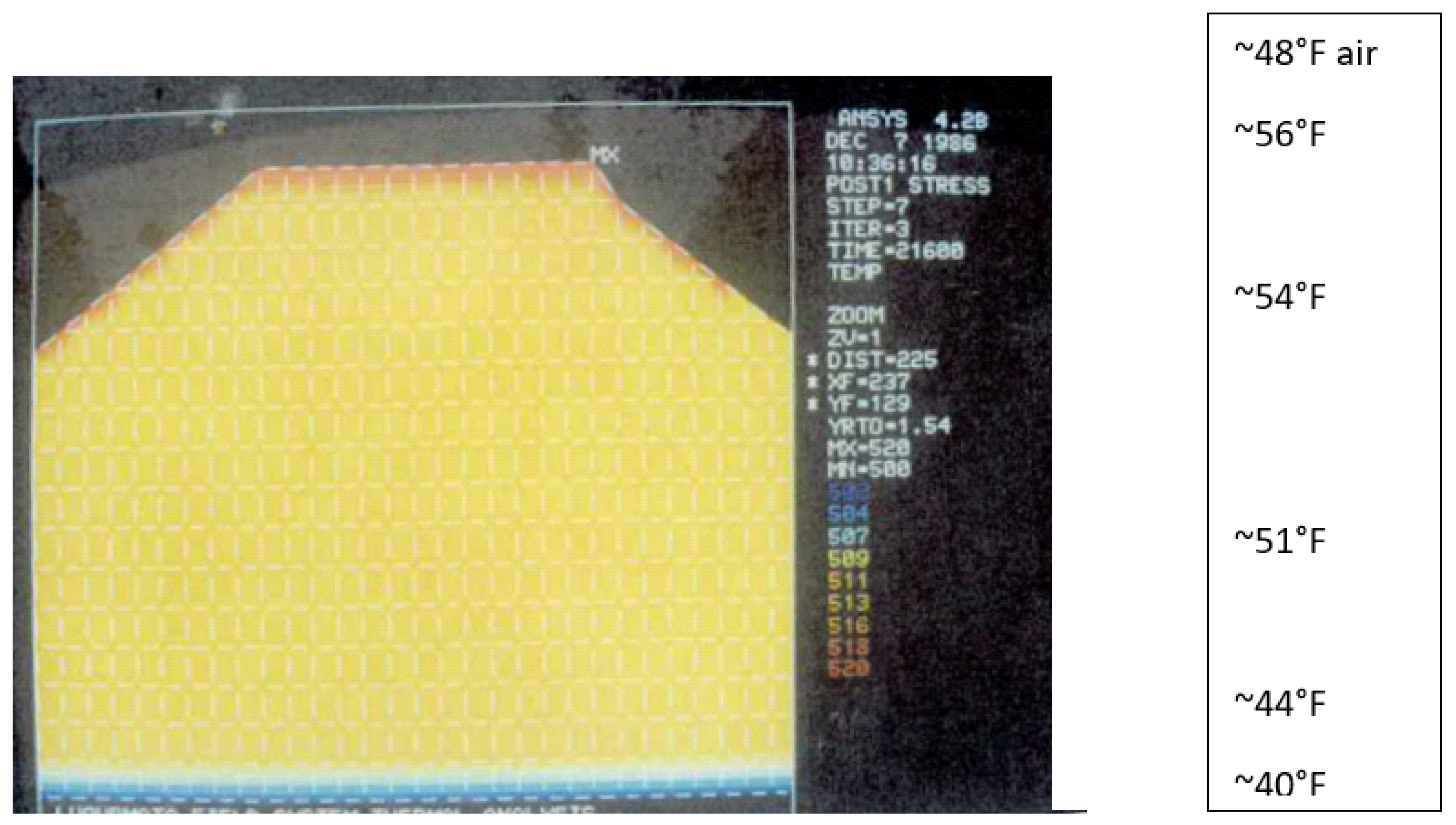
Figure 9 presents a berm surface temperature of ~39 °F, a lower groundwater aquifer temperature of ~43 °F and a residual nightly berm interior temperature of ~47 °F, resulting from previous day’s solar activity. This initial case occurs early in the morning hours, when solar IR radiation generates low values (
Figure 7). This case represents the residual temperature distribution from the previous day. The insulation layer (
Figure 2) serves to limit any heat stored in the berm interior from transferring into the deep groundwater base layer; however, due to its moist soil–rock–pebble composition, its thermal diffusivity is not significantly different from the regular berm soil composition and properties, which renders its insulation effect somewhat minor for the current example case.
In
Figure 9, it is apparent that incipient solar IR radiation is in the beginning stage of warming the cold near-top surface of the berm, and residual heat remains in the berm interior, generated by the diurnal warming from solar IR radiation from the previous day and night. In
Figure 8, note that the cold, early morning air temperature of ~39 °F was effective in removing the heat from the berm top region due to its early morning low temperatures, and it likely had the effect of lowering interior berm temperatures during previous dark night hours. The temperatures shown in
Figure 9,
Figure 10,
Figure 11,
Figure 12 and
Figure 13 are given in degrees Fahrenheit and are to be considered as the mean temperatures in different raised-field zones. It is noted that residual temperature maxima occur within the berm due to the low thermal diffusivity of soil and water compared to the adjacent air. Note also that the low groundwater temperature ensures a thermal gradient, thereby improving the input solar heat transfer in later hours. The zone of interest to root crops is that between the berm soil surface and the water height in the swales; observations of the soil temperature below the top surface and above the insulation layer indicate the residual temperature left over from previous night’s heat transfer activities. The origin of this residual heat derived from next day’s thermal conditioning is given in
Figure 9,
Figure 10,
Figure 11,
Figure 12 and
Figure 13, as derived from the ANSYS calculations.
Figure 10 presents the solar IR radiative heating of the top berm surface to new highs, as the radiative flux in
Figure 7 approaches its maximum noontime value, and the air temperature increases (
Figure 8). Heat transfer from the moist berm top surface proceeds to transfer heat to berm interior regions, as evidenced in the comparative region temperatures shown in
Figure 9. At greater depths within the berm interior, the heat transfer values are yet to be significantly influenced by more than a few degrees of temperature rise compared to
Figure 9 results, which indicate that the time of heat transmission advances depends upon the κ value of the moist berm interior soil mixture. Outer air temperature (
Figure 8) is also rising, contributing to berm interior heating. The lower insulation layer (
Figure 2) serves to somewhat limit the heat transfer to the lower and colder groundwater aquifer, increasing the berm depth heat storage capacity and temperature rise within the berm interior volume. Some asymmetries in the top surface temperature distribution can arise due to the orientation of raised fields with respect to the sun’s trajectory path, causing shadows and lower values of received solar radiation in different parts of the berm surface, as indicated in
Figure 10.
Clearly, the remnant heat storage at its 47 °F temperature from prior day’s activities can accept more heat at higher temperatures from solar radiative input and higher air temperatures, given the insulation layer’s blocking of colder deep aquifer temperatures, which would cause yet further heat transfer from the berm internal region. The rising berm soil temperatures over time have the consequence of preventing, or at least ameliorating, root crop damage during subfreezing altiplano nights. Although several degrees Fahrenheit separate the internal from the external temperatures at night, this internal berm temperature difference is instrumental in keeping the internal ground temperature above the freezing limit at depths where root crops exist. As freezing air temperatures are often encountered over raised fields, a certain amount of time is required to extract the latent heat for ice formation from the moist berm soils before total freezing can destroy root crops; root crops fail when their contained water solidifies to ice. The presence of berm heat storage capability is therefore important for root crop survival. The latent heat removal for producing solid ice occurs at the 32 °F constant temperature. The latent heat removal through berm soil conduction delays berm internal temperature decrease with an increase in time. The berm internal temperature decrease is further delayed by the increasing solar IR heat input, air temperature increases, and swale water temperature increases during early mornings and latent heat removal time, which helps retain higher than freezing internal berm temperatures. The freezing of plant parts at the berm soil surface is likewise delayed by the berm surface heat absorption effect, which helps maintain temperatures slightly higher than the ambient air temperature.
Archeological evidence from the excavated Tiwanaku raised fields indicates that native aquatic reed macrophytes, such as
Miriophillum Etodea,
Potamogeton,
Ruppia and
Schoenoplectus tortora, were dredged from swales and used in combination with land crop remains as green manure to replenish nitrogen and potassium in the berm soil [
12,
26,
29,
31]. The decomposition of this plant material in a blackened state placed in swale bottoms served as a solar radiation trap for raising the water temperature, adding further heat to berm soils. Although the field system patterns change locally and receive different solar flux rates with respect to the sun’s path, and they may have different soil types and berm heights, together with different crop types subject to different air temperature levels and wind speeds, the analysis presented is expected to apply in a general qualitative sense.
Heat transfer proceeds an hour or two past peak solar radiation times (
Figure 8) to further decrease and distribute internal berm moist soil temperatures as the heat transfer proceeds to decrease the temperature gradients over time (
Figure 11). As higher temperature berm soil now exists at lower levels close to the thermal insulation layer, the temperature gradient in this region is high, leading to increased heat transfer to the lower temperature groundwater aquifer and lowering the soil temperature above the insulation layer by a few degrees. This near-uniform stage in berm heating is ideal for both root and surface crops, as higher temperatures at greater soil depths benefit increased root crop growth, as well as for other deep root crop varieties. Swale water temperatures are high in order to reduce heat loss from the berm interior before air temperatures (
Figure 8) begin to decline.
In
Figure 9, it is apparent that when the berm surface temperatures are a few degrees above freezing values, at least a ~20 °F internal berm soil temperature rise can occur to prevent crop freezing despite low air ambient temperatures. This—together with the latent heat removal requirement, which requires a significant time lag to absorb heat from the berm interior region to induce water-to-ice transition in root crops—creates ideal conditions for preventing crop freezing from occurring.
As night-time low air temperatures begin to prevail, heat is transferred from the berm interior through the insulation layer more effectively due to the high temperature gradient and the clay–rock–pebble insulation layer composition, which is similar in composition to berm soils but fully saturated in order to limit insulation capabilities (
Figure 12). Further heat loss occurs due to night-time low air temperatures (
Figure 8), which can drop well below freezing. Heat loss during cold nights occurs, as solar IR radiation is no longer present (
Figure 7), and swale water temperatures drop significantly to extract further heat from the berm interior. Heat is lost through the insulation layer to the cold groundwater aquifer layer. Despite these night-time heat losses and temperature decreases, sufficient heat and elevated temperatures exist in the berm interior to prevent freezing crop loss, which is the original conceptualization of the berm design in
Figure 2 by Tiwanaku water (and heat transfer) engineers for sustaining crops during cold winter nights or at least extending the growing season for crops as the winter approaches with cold temperatures, which limit crop types, which can survive winter conditions. The internal berm heat storage effect is realized at early sunset as a survival means to sustain a vital part of the intensive agricultural base to maintain the continuity and provisioning of the Tiwanaku urban population in a production context of rigorous seasonal changes in environmental weather patterns.
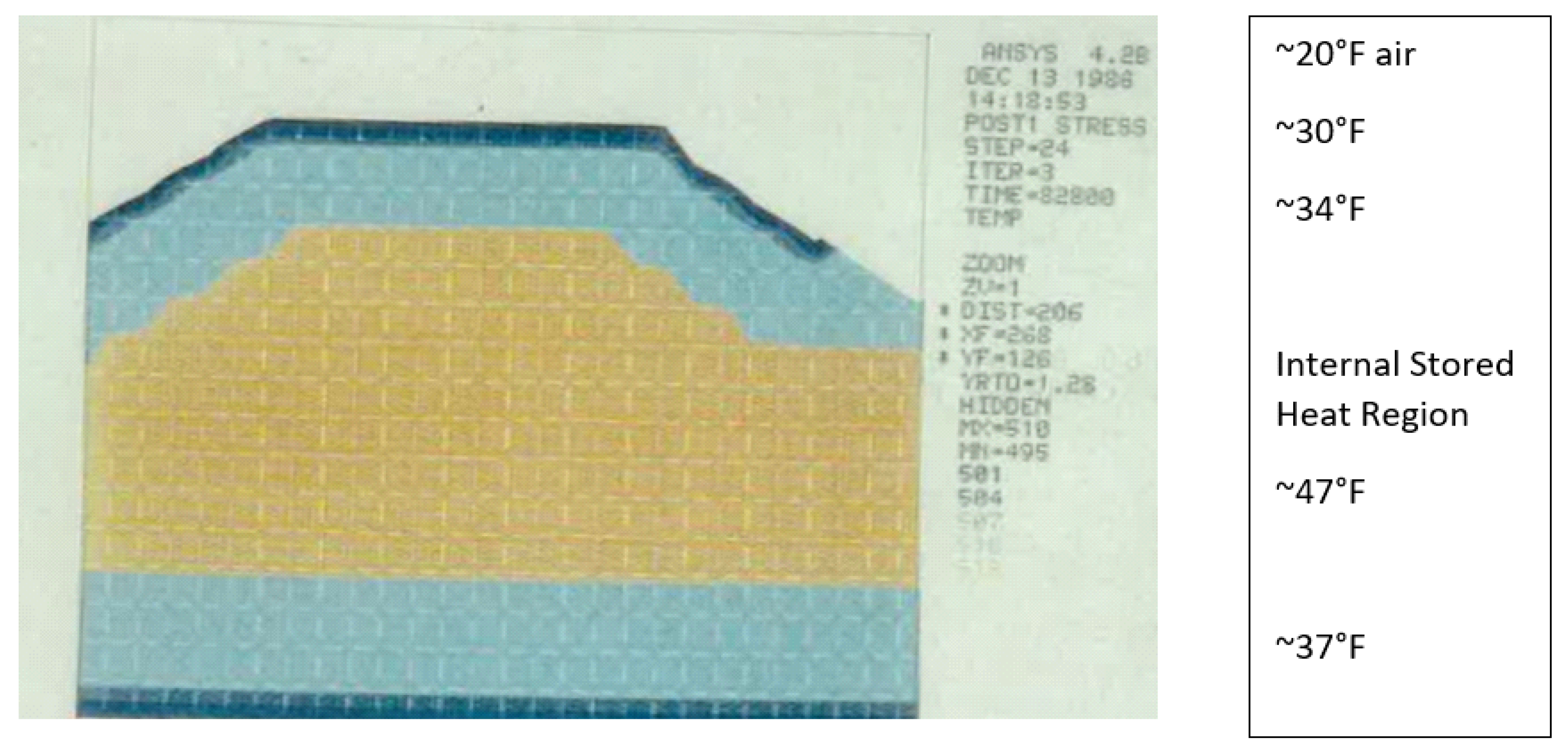
Figure 13 indicates that in the later night-time periods approaching early morning, the further heat transfer from the top berm surface and the lower berm layer above the insulation layer still leaves an internal zone of temperatures higher than freezing temperatures of 32 °F. Further night-time heat transfer occurs from the berm surface due to cold ambient air temperatures, as well as further heat transfer into the lowermost deep groundwater aquifer through the partially ineffective saturated insulation layer. The substantial residual inner berm core region temperature value—which exists at night, before sunrise and solar IR heating commence—therefore facilitates the survival of root crops, sustaining a vital part of the diet of the population of urban Tiwanaku throughout the winter season. As swale water temperature is higher than ambient air temperature at night (
Figure 8), this serves to add heat to the heat storage of high thermal diffusivity soils. As Tiwanaku also maintained satellite communities at lower elevation levels, capable of growing a wide variety of different surface crops, as well as nearby satellite communities with different soil types subject to different climatic conditions, the importation of additional food crops combined with lacustrine resources and large-scale camelid herds provided the rich nutrient resources for sustaining the Tiwanaku society.
The net result related to internal berm heat storage derived from the ANSYS calculations is shown in
Figure 13; this figure demonstrates an internal heat storage region, which promotes the survival of key root crops.
As a program of excavation and rehabilitation of ancient raised-field systems demonstrated in the late 1980s and early 1990s, the crop yields from experimental raised fields exceeded those from contemporary dry-farmed fields in use by contemporary groups [
24]. Farm crop yield output from rehabilitated raised fields has been shown to be orders of magnitude greater than that generated by contemporary farmers, who farmed in similar areas of the reclamation project. Details of this reclamation project and the innovative heat transfer technologies used in ancient berm construction are discussed in
Section 6 and the previously cited references [
12,
14,
21,
29], and they are commensurate with the results of internal berm heat storage protecting root crops from freezing damage presented in
Figure 13.
7. Discussion
The present analysis presents new ANSYS graphic analysis results (
Figure 9,
Figure 10,
Figure 11,
Figure 12 and
Figure 13), indicating day-to-night internal berm heat transfer effects within a raised-field berm layer. Additional commentary, beyond that of earlier references [
12,
13,
19], includes a revised commentary on the various heat transfer effects occurring during a 24 h time cycle, as well as further commentary on seasonal groundwater regulation for maintaining swale groundwater level constant using a river-sourced canal, which supplies water to the field systems during the dry season and shunts excess water to Lake Titicaca during the rainy season. Additional references detailing the considerations of variations in air and ground layer thermophysical properties operational in raised-field agricultural systems are included in
Section 4 and
Section 5.
For background into the history of Tiwanaku and its unique agricultural system, which flourished by virtue of the raised-field berm heat storage capability for sustaining agricultural production through seasonal rainfall and air temperature changes, the following discussion provides the background history of the Tiwanaku state’s agricultural system affected by climate change effects.
The Tiwanaku state flourished from c. 500 to 1100 CE. Commencing around c. 1100 CE, the Tiwanaku society began to collapse from social and economic dislocations induced by a long-term drought, which lasted several centuries [
23,
25,
26]. Similar decline of the contemporary Wari society in the same time period has been noted, as well as the drought effects challenging north Peruvian coastal Chimú society over the same (c. 1000 CE) time period [
21]. As the raised-field systems depended on swale water, spring canalized water and constant groundwater level to sustain agriculture, the extensive post-c. 1100 CE Andean drought gradually lowered the groundwater height to a level at which the raised-field swales no longer held sufficient water to sustain agriculture. This led to abandonment of the raised-field system’s agricultural base and the ultimate collapse and dispersal of the urban Tiwanaku society.
Realizing that the Bolivian altiplano region experiences freezing air temperatures, which challenge the survival of food crops, Tiwanaku agricultural engineers created a raised-field design, which provided a solution to the perennial threat of killing frost, which caused crop destruction. Although the results obtained in this paper rely on contemporary heat transfer nomenclature and modern computer analysis methodologies, it may be surmised from the long-term empirical observations and solutions employed by Tiwanaku agriculturalists that their focus was on agricultural productivity. Tiwanaku’s technical specialists understood the necessity for berm interior heat storage to protect crops from freezing destruction in their indigenous understanding of the engineering format—yet to be discovered—which guided the creation of the raised-field model shown in
Figure 2. The excavations performed on the Pampa Koani site at greater depths (~5 m) indicated an earlier version of raised-field geometry, with berms of much narrower width with larger width swales; this earlier version was revised in later times by a new design with wider berms and minimized swale widths, which maximized the agricultural area [
31]. This sequence of technological advancements over time indicates an active experimental framework for experimenting with agricultural efficiency advancements on a trial-and-error basis in order to increase agricultural production.
That an active investigative engineering process, involving pre-Columbian versions of modern technical terms and procedures, existed in ancient South America for advancing urban living standards and agricultural productivity is now apparent. This process continually updated the efficiency of raised-field productivity, supporting the increasing urban population over seasonal changes in climate and weather patterns.
An experimental confirmation [
12,
14,
31] of the heat conservation effects was obtained during the 1987–1988 growing season in the Pampa Koani area adjacent to urban Tiwanaku through observations of crop survival on a ~1.5-hectare plot of land, using reconstructed ancient raised-field systems, which supported potato crops. Adjacent land plots, utilizing shallow furrow dry farming on plains and hillslopes planted with potatoes traditionally used by local farmers, were located nearby. One winter night, a subzero frost pervaded both field systems, permitting observations of frost damage in both field system types. Fields cultivated through surface furrow farming demonstrated near total root crop destruction; in contrast, losses in the reconstructed ancient raised fields were limited to only superficial frost damage to potato leaves, with no apparent damage to the subsurface roots. Similarly, crops of quinoa, cañiwa, onions and non-native crops, such as lettuce, were substantially unaffected [
12,
14,
19,
24,
29] in the reconstructed raised fields compared to total loss in the dry-farmed, long furrow system. Subsequent testing of the results obtained from both field system types included several 100 m
2 test plots with potato plantings in reconstructed raised fields, which yielded 33 metric tons per hectare compared to 3–8 metric tons per hectare obtained from shallow furrow dry-farming techniques practiced in the same area during Spanish Colonial times. This order of magnitude agricultural yield difference is attributed to both the internal berm heat storage advantage of the ancient raised-field design, together with the drainage of excess water from elevated berm areas in order to maintain the proper moisture level for crop growth when subjected to subfreezing air temperatures. The current shallow furrow field design, in contrast, suffers waterlogging of agricultural soils from insufficient rainfall drainage, killing frost, which promotes crop destruction from flooding, and increased susceptibility to freezing destruction of all crop types. On this basis, the field systems of ancient Tiwanaku agriculturalists far exceed in productivity and technological sophistication those used in current times.

