
Identification of Potential Landslide Hazards Using Time-Series InSAR in Xiji County, Ningxia
 ,
,
Abstract
:1. Introduction
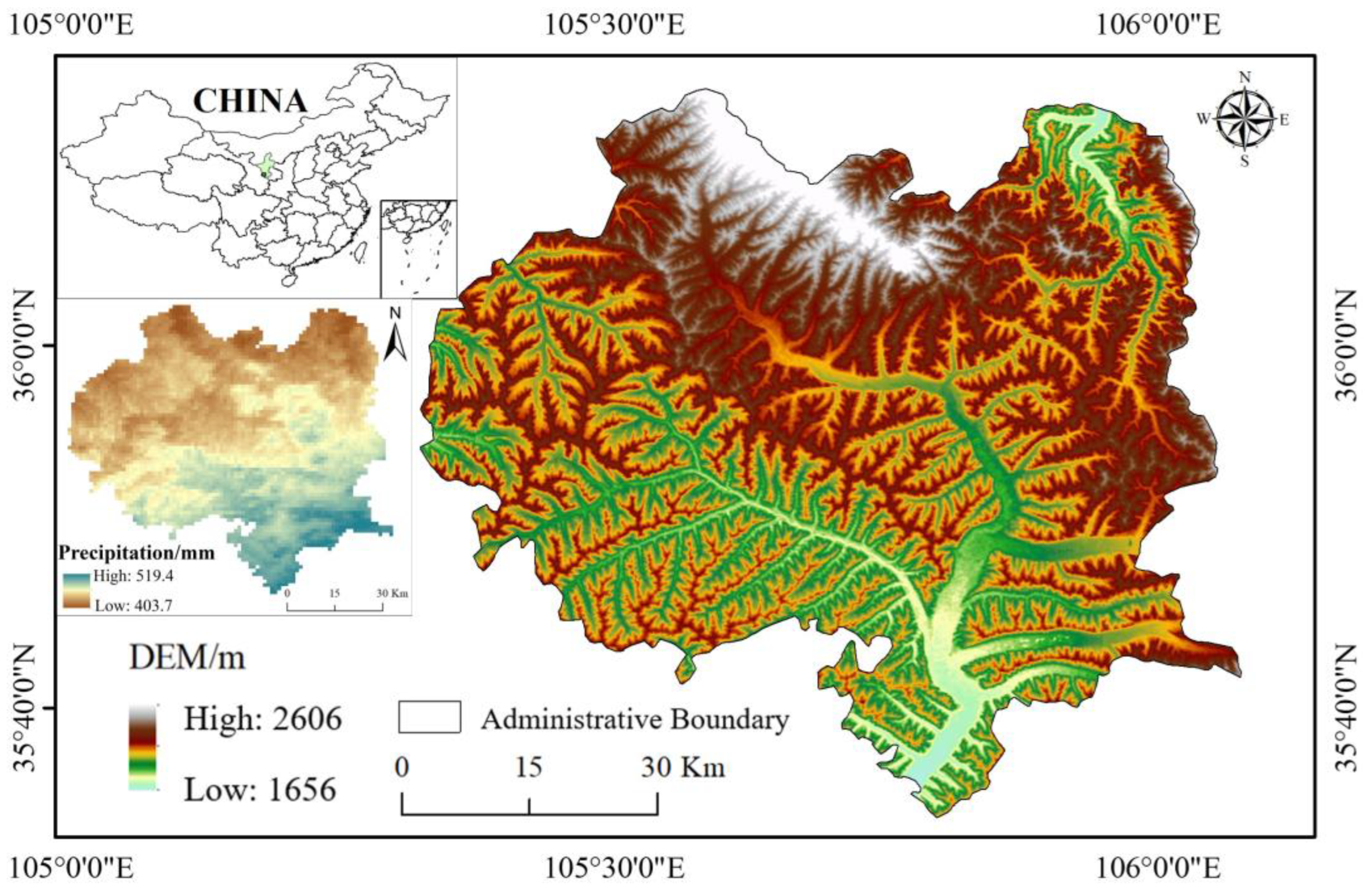
2. Study Area
3. Data and Methods
3.1. Experimental Data
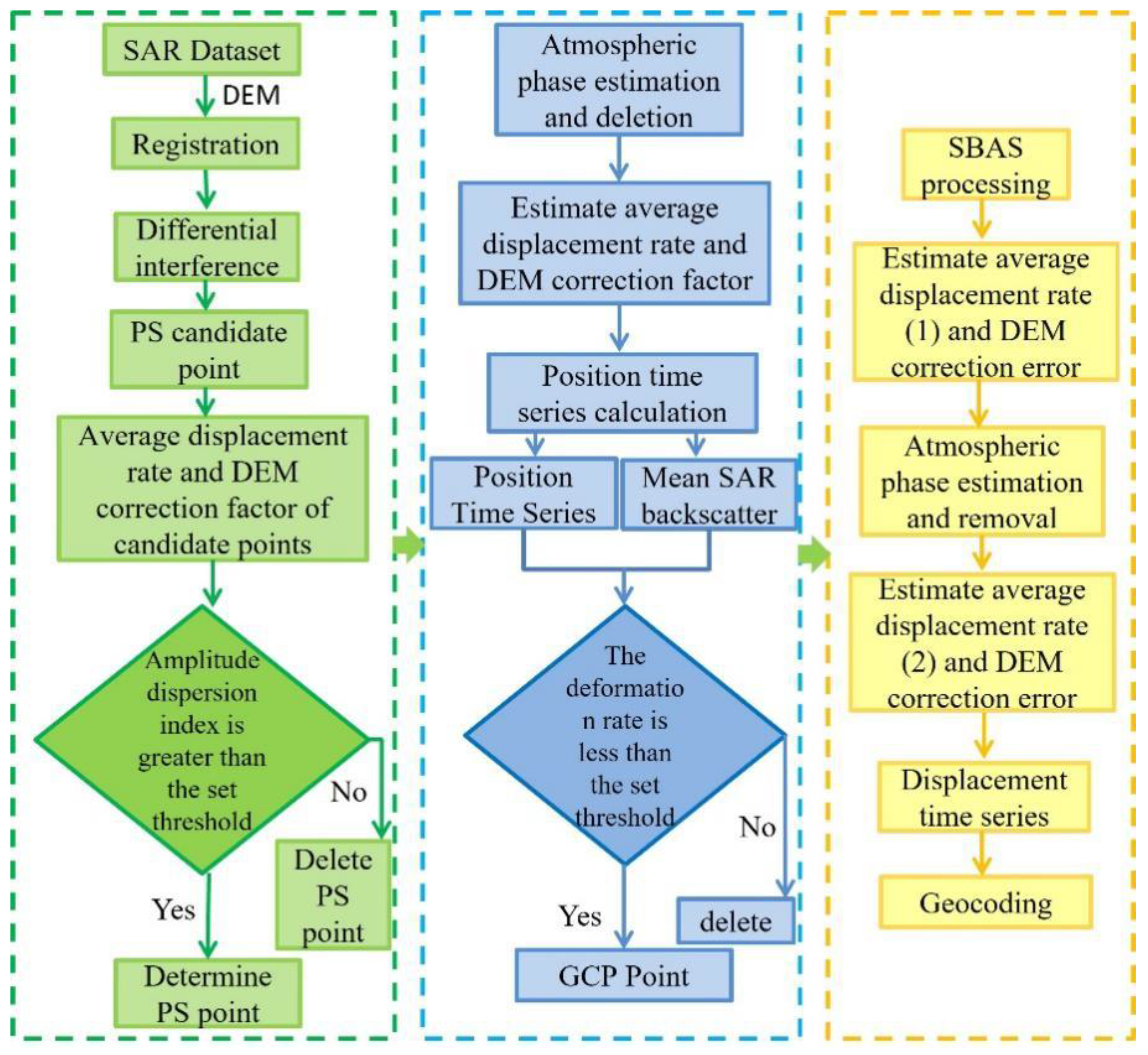
3.2. Time-Series InSAR Methods
3.3. Monitoring of Surface Deformation in Mountainous Areas
4. Result Analysis
4.1. Identification of Potential Landslide Hazards
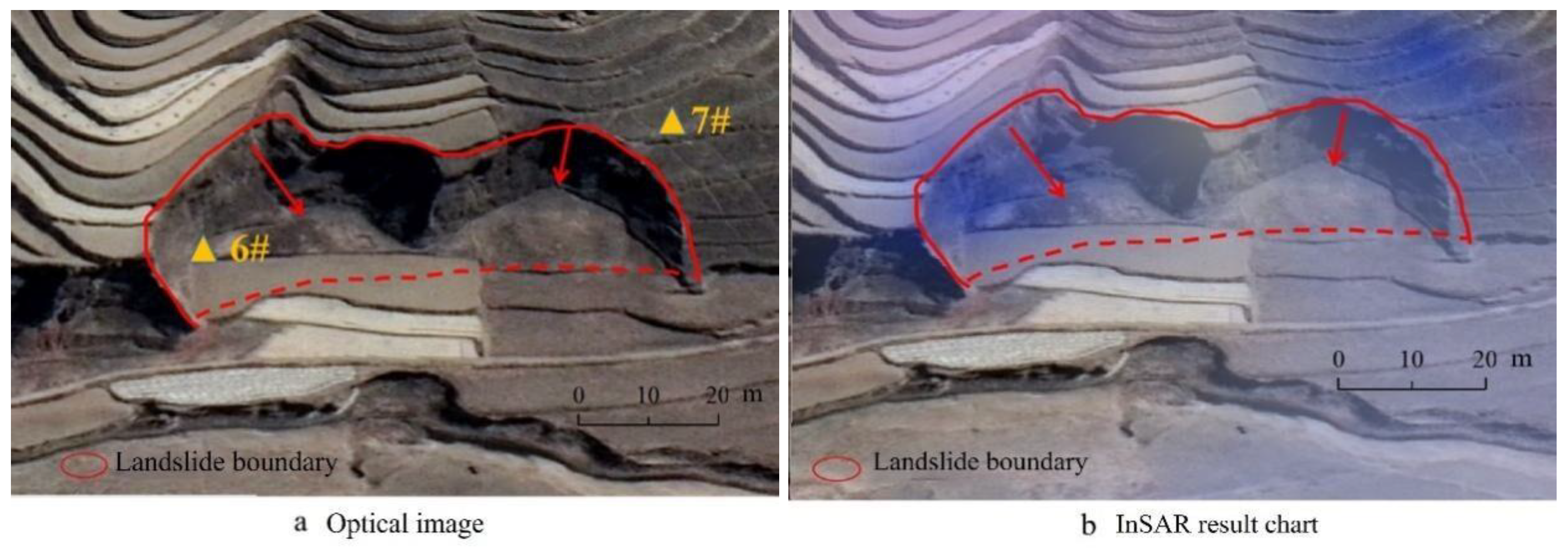
4.2. Analysis of Spatiotemporal Characteristics of Typical Potential Landslides
5. Discussion
6. Conclusions
- (1)
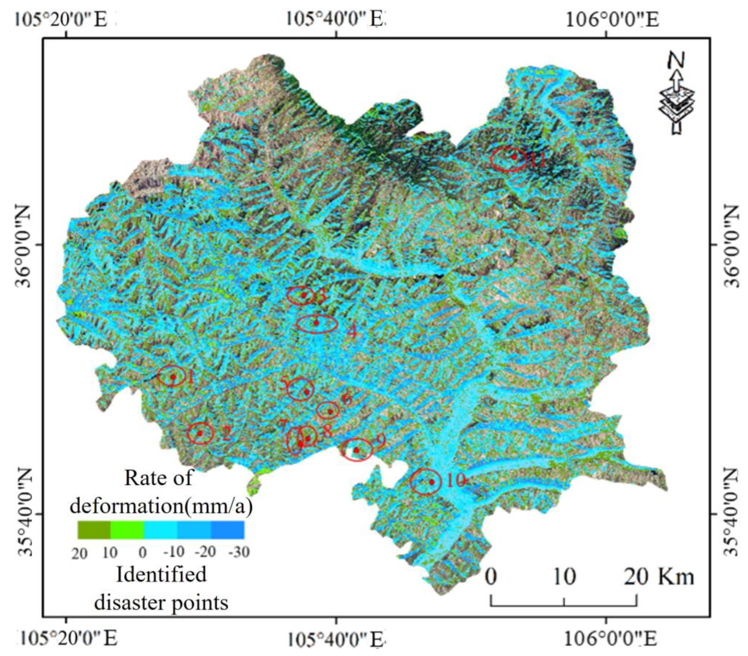
- According to the fusion technology of PS and SBAS, the cumulative deformation volume and deformation rate of the surface from 2018 to 2021 were monitored. The results showed that the whole study area presented a relatively stable state, that the maximum cumulative deformation within the region was −55 mm, and that the southwest slope is the main deformation area in Xiji County.
- (2)
- Early identification of potential landslides was carried out based on radar line-of-sight deformation rate maps and optical images, and 11 potential landslides (including three historical collapses) were identified in Xiji County, which is highly consistent with the field survey results. The feasibility and reliability of potential landslide identification for slope stability analysis are verified, which can provide certain data support for potential landslide investigation, the layout of major engineering facilities, and disaster prevention and reduction work in the region.
- (3)
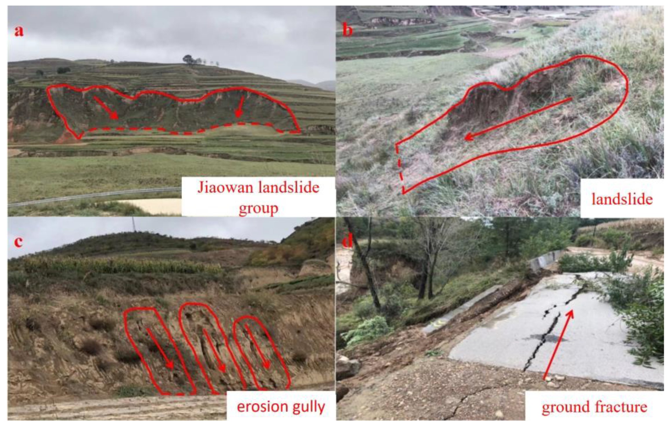
- The 11 potential landslide hazard points identified in this study all belong to the slope that has been damaged and deformed under natural and artificial conditions. Among them, the Jiaowan landslide is in a basically stable state at present, but creep phenomenon often occurs in the rainy season, especially the heavy rain season, and water accumulation is easy behind the slope.
Author Contributions
Funding
Data Availability Statement
Acknowledgments
Conflicts of Interest
References
- Ge, D.Q.; Dai, K.R.; Guo, Z.C.; Li, Z.H. Early Identification of Serious Geological Hazards with Integrated Remote Sensing Technologies: Thoughts and Recommendations. Geomat. Inf. Sci. Wuhan Univ. 2019, 44, 949–956. [Google Scholar] [CrossRef]
- Zhang, W.; LI, Y.Y.; Zhang, T.L.; Gui, L.; Zhou, C. Remote Sensing Interpretation of Landslide Geological Hazards in High Vegetation Coverage Area Based on Hazard Sensitivity Analysis. Saf. Environ. Eng. 2019, 26, 28–35. [Google Scholar] [CrossRef]
- Burgmann, R.; Rosen, P.; Fielding, E. Synthetic Aperture Radar Interferometry to Measure Earth’s Surface Topography and Its Deformation. Annu. Rev. Earth Planet. Sci. 2000, 28, 169–209. [Google Scholar] [CrossRef]
- Shi, F.C.; Tang, Z.H.; Chen, Y.B.; Zhu, F.; Ye, S. Spatial-temporal Evolution Characteristics and Causes of Land Subsidence in Typical Area of Eastern Guangdong Province. Saf. Environ. Eng. 2019, 26, 8–16. [Google Scholar] [CrossRef]
- Rott, H.; Nagler, T. The contribution of radar interferometry to the assessment of landslide hazards. In Natural Hazards and Oceanographic Processes from Satellite Data; Singh, R.P., Shea, M.A., Eds.; Elsevier: Amsterdam, The Netherlands, 2006; pp. 710–719. [Google Scholar]
- Berardino, P.; Fornaro, G.; Lanari, R.; Sansosti, E. A new algorithm for surface deformation monitoring based on small baseline differential SAR interferograms. IEEE Trans. Geosci. Remote Sens. 2002, 40, 2375–2383. [Google Scholar] [CrossRef] [Green Version]
- Lanari, R.; Mora, O.; Manunta, M.; Mallorqui, J.J.; Berardino, P.; Sansosti, E. A small-baseline approach for investigating deformations on full-resolution differential SAR interferograms. IEEE Trans. Geosci. Remote Sens. 2004, 42, 1377–1386. [Google Scholar] [CrossRef]
- Xu, S.; Wang, S.X.; Niu, R.Q. Identification of the Potential Landslide in Wushan–Fengjie in the Three Gorges Reservoir Area Based on InSAR Technology. Saf. Environ. Eng. 2020, 27, 32–38. [Google Scholar] [CrossRef]
- Zhu, J.J.; Li, Z.W.; Hu, J. Research Progress and Methods of InSAR for Deformation Monitoring. Acta Geod. Cartogr. Sin. 2017, 46, 1717–1733. [Google Scholar]
- Li, M.S.; Wang, T. Time Series Insar Technology and Application; Science Press: Beijing, China, 2014. [Google Scholar]
- Li, X.E.; Zhou, L.; Su, F.Z.; Wu, W.Z. Application of InSAR technology in landslide hazard: Progress and prospects. Natl. Remote Sens. Bull. 2021, 25, 614–629. [Google Scholar]
- Shi, X.G. Method and Application of Landslide Surface Deformation Monitoring Based on On-Board Radar Remote Sensing; Wuhan University: Wuhan, China, 2016. [Google Scholar]
- Zhao, B.Q. Surface Deformation Characteristics and Early Identification of Potential Landslides Based on InSAR Technology in Bailong River Basin; Lanzhou University: Lanzhou, China, 2019. [Google Scholar]
- Wang, Z.W. Research on Landslide Identification Method of Datong County in Qinghai Based on SBAS-InSAR Technology; Chengdu University of Technology: Chengdu, China, 2019. [Google Scholar]
- Li, G.Y. Landslide Identification and Monitoring in the Middle Reaches of Bailong River Using Sentinel-1A; Nanjing Normal University: Nanjing, China, 2018. [Google Scholar]
- Zhao, C.Y.; Liu, X.J.; Zhang, Q.; Peng, J.B.; Xu, Q. Research on Loess Landslide Identification, Monitoring and Failure Mode with InSAR Technique in Heifangtai, Gansu. Geomat. Inf. Sci. Wuhan Univ. 2019, 44, 996–1007. [Google Scholar] [CrossRef]
- Xu, Q. Understanding and Consideration of Related Issues in Early Identification of Potencial Geohazards. Geomat. Inf. Sci. Wuhan Univ. 2020, 45, 1651–1659. [Google Scholar] [CrossRef]
- Chi, Y. Early warning, Beidou/GNSS monitoring system to avoid casualties. Space Explor. 2019, 39, 5. [Google Scholar]
- Zhang, Y.; Meng, X.M.; Chen, G.; Qiao, L.; Zeng, R.Q.; Chang, J. Detection of geohazards in the Bailong River Basin using synthetic aperture radar interferometry. Landslides 2016, 13, 1273–1284. [Google Scholar] [CrossRef]
- Huo, A.; Zhao, Z.; Luo, P.; Zheng, C.; Peng, J.; Abuarab, M.E.-S. Assessment of Spatial Heterogeneity of Soil Moisture in the Critical Zone of Gully Consolidation and Highland Protection. Water 2022, 14, 3674. [Google Scholar] [CrossRef]
- Huo, A.; Wang, X.; Zhao, Z.; Yang, L.; Zhong, F.; Zheng, C.; Gao, N. Risk Assessment of Heavy Metal Pollution in Farmland Soils at the Northern Foot of the Qinling Mountains, China. Int. J. Environ. Res. Public Health 2022, 19, 14962. [Google Scholar] [CrossRef]
- Lu, T.; Huo, A.; Wang, J.; Lu, Y.; Zhou, W. Hydrodynamic Behaviors and Geochemical Evolution of Groundwater for Irrigation in Yaoba Oasis, China. Water 2022, 14, 3924. [Google Scholar] [CrossRef]
- Hui, S.; Wankui, N.; Haisong, L. Development Characteristics and Distribution of Earthquake-induced Loess Landslides in Xiji County of Ningxia Hui Autonomous Region. Bull. Soil Water Conserv. 2012, 32, 28–31. [Google Scholar] [CrossRef]
- Ferretti, A.; Prati, C.; Rocca, F. Nonlinear subsidence rate estimation using permanent scatterers in differential SAR interferometry. IEEE Trans. Geosci. Remote Sens. 2000, 38, 2202–2212. [Google Scholar] [CrossRef] [Green Version]
- Cheng, J.; Aidi, H.; Xinghua, Z.; Hong, W.; Xiaolu, Z.; Xiaofan, W. Research status of loess hydraulic erosion-landslide-mudflow chain. J. Nat. Disasters 2019, 28, 38–43. [Google Scholar] [CrossRef]
- Peng, J.B.; Huo, A.D.; Cheng, Y.X.; Dang, J.; Wei, H.; Wang, X.F.; Li, C.Y. Submersion simulation in a typical debris flow watershed of Jianzhuangchuan catchment, Loess Plateau. Environ. Earth Sci. 2017, 76, 462. [Google Scholar] [CrossRef]
- Cheng, Y.X.; Huo, A.D.; Zhao, Z.X.; Peng, J.B. Analysis of loess fracture on slope stability based on centrifugal model tests. Bull. Eng. Geol. Environ. 2021, 80, 3647–3657. [Google Scholar] [CrossRef]
- Huo, A.D.; Peng, J.B.; Cheng, Y.X.; Zheng, X.L.; Wen, Y.R. Temporal Characteristics of the Rainfall Induced Landslides in the Chinese Loess Plateau (China). In Proceedings of the 1st Springer Conference of the Arabian-Journal-of-Geosciences (CAJG), Hammamet, Tunisia, 12–15 November 2018. [Google Scholar]
- Huo, A.D.; Yang, L.; Peng, J.H.; Cheng, Y.X.; Jiang, C. Spatial characteristics of the rainfall induced landslides in the Chinese Loess Plateau. Hum. Ecol. Risk Assess. 2020, 26, 2462–2477. [Google Scholar] [CrossRef]
- Crozier, M.J. A proposed cell model for multiple-occurrence regional landslide events: Implications for landslide susceptibility mapping. Geomorphology 2017, 295, 480–488. [Google Scholar] [CrossRef]
- Zhao, H.Q.; Yi, W.; Huang, H.F.; Xia, J.B. Analysis of Water Content and Stability of Reservoir Landslides with Different Rainfall Intensities. Saf. Environ. Eng. 2016, 23, 53–58. [Google Scholar] [CrossRef]
- Xu, G.H.; He, X.F.; Wang, G.R.; Hu, Z.Y.; Cheng, X.; Li, X.Q. InSAR identification and cause analysis of landslide disaster in Ningxia (Xiji county) section of the Yellow River basin. Bull. Surv. Mapp. 2022, 68, 104–107. [Google Scholar] [CrossRef]
- Chen, S.M.; Huo, A.D.; Zhang, J.; Zhao, Z.Z.; Chen, S.B.; Chen, J. Identification of Potential Landslides in the Loess Hilly Area (Xiji County) of Ningxia with InSAR Technology. Sci. Technol. Eng. 2022, 22, 4721–4728. [Google Scholar]
- Hungr, O.; Leroueil, S.; Picarelli, L. The Varnes classification of landslide types, an update. Landslides 2014, 11, 167–194. [Google Scholar] [CrossRef]
- Yang, L.X. Causes, Characteristics and prevention strategies of landslide geological disasters in Yuanzhou District, Guyuan City, Ningxia. China Met. Bull. 2020, 28, 195–196. [Google Scholar]


| Number | Image Date | Number | Image Date | Number | Image Date | Number | Image Date |
|---|---|---|---|---|---|---|---|
| 1 | 18 December 2018 | 8 | 22 July 2019 | 15 | 30 March 2020 | 22 | 24 December 2020 |
| 2 | 23 January 2019 | 9 | 20 September 2019 | 16 | 23 April 2020 | 23 | 24 January 2021 |
| 3 | 28 February 2019 | 10 | 26 October 2019 | 17 | 29 May 2020 | 24 | 22 February 2021 |
| 4 | 24 March 2019 | 11 | 19 November 2019 | 18 | 22 June 2020 | 25 | 25 March 2021 |
| 5 | 29 April 2019 | 12 | 25 December 2019 | 19 | 14 August 2020 | 26 | 23 April 2021 |
| 6 | 23 May 2019 | 13 | 30 January 2020 | 20 | 25 October 2020 | 27 | 24 May 2021 |
| 7 | 28 June 2019 | 14 | 23 February 2020 | 21 | 30 November 2020 | 28 | 17 June 2021 |
| Number | Length/m | Width/m | Thickness/m | Volume/m3 | Threat Object | Landslide Scale |
|---|---|---|---|---|---|---|
| 1 | 100 | 600 | 5–10 | 3,825,000 | Residential highway | Large loess landslide |
| 2 | 200 | 300 | 5–10 | 3,062,500 | Settlement | Large loess landslide |
| 3 | 300 | 400 | 5–10 | 40,000 | Settlement | Small loess landslide |
| 4 | 210 | 470 | 25 | 2,438,800 | Settlement | Large loess landslide |
| 5 | 100 | 200 | 5–10 | 5,400,000 | Settlement | Large loess landslide |
| 6 | 200 | 200 | 5–15 | 5,390,000 | Settlement | Large loess landslide |
| 7 | 200 | 1000 | 10–15 | 13,062,500 | Settlement | Giant loess landslide |
| 8 | 1500 | 1000 | 25 | 37,500,000 | Settlement | Giant loess landslide |
| 9 | 500 | 950 | 25 | 11,875,000 | Settlement | Giant loess landslide |
| 10 | 300 | 1100 | 20 | 6,600,000 | Residential highway | Large loess landslide |
| 11 | 500 | 500 | 20 | 1,000,000 | Settlement | Large loess landslide |
Disclaimer/Publisher’s Note: The statements, opinions and data contained in all publications are solely those of the individual author(s) and contributor(s) and not of MDPI and/or the editor(s). MDPI and/or the editor(s) disclaim responsibility for any injury to people or property resulting from any ideas, methods, instructions or products referred to in the content. |
© 2023 by the authors. Licensee MDPI, Basel, Switzerland. This article is an open access article distributed under the terms and conditions of the Creative Commons Attribution (CC BY) license (https://creativecommons.org/licenses/by/4.0/).
Share and Cite
Zhang, J.; Gong, Y.; Huang, W.; Wang, X.; Ke, Z.; Liu, Y.; Huo, A.; Adnan, A.; Abuarab, M.E.-S. Identification of Potential Landslide Hazards Using Time-Series InSAR in Xiji County, Ningxia. Water 2023, 15, 300. https://doi.org/10.3390/w15020300
Zhang J, Gong Y, Huang W, Wang X, Ke Z, Liu Y, Huo A, Adnan A, Abuarab ME-S. Identification of Potential Landslide Hazards Using Time-Series InSAR in Xiji County, Ningxia. Water. 2023; 15(2):300. https://doi.org/10.3390/w15020300
Chicago/Turabian StyleZhang, Jia, Yongfeng Gong, Wei Huang, Xing Wang, Zhongyan Ke, Yanran Liu, Aidi Huo, Ahmed Adnan, and Mohamed EL-Sayed Abuarab. 2023. "Identification of Potential Landslide Hazards Using Time-Series InSAR in Xiji County, Ningxia" Water 15, no. 2: 300. https://doi.org/10.3390/w15020300