Article

Impact of Large Reservoirs on Runoff and Sediment Load in the Jinsha River Basin

1
Key Laboratory of Water Cycle and Related Land Surface Processes, Institute of Geographic Sciences and Natural Resources Research, Chinese Academy of Sciences, Beijing 100101, China
2
College of Resources and Environment, University of Chinese Academy of Sciences, Beijing 100049, China
3
Xinjiang Institute of Ecology and Geography, Chinese Academy of Sciences, Urumqi 830011, China
*
Author to whom correspondence should be addressed.
Water 2023, 15(18), 3266; https://doi.org/10.3390/w15183266
Submission received: 21 July 2023 / Revised: 8 September 2023 / Accepted: 12 September 2023 / Published: 14 September 2023
(This article belongs to the Special Issue Sediment Transport in Open Channel Flow)

Abstract

:
To develop clean energy hydropower, many dams were built in the Jinsha River Basin in the past thirty years and have significantly altered runoff and sediment transport processes. This study aims to evaluate the impacts of these reservoirs on runoff and sediment transport using data collected in the mainstream of the Jinsha River from the 1960s to 2020, for which the Mann–Kendall trend test method and double cumulative curve method are used to comprehensively judge the variation trends of annual runoff and suspended sediment load (SSL) and reveal the years in which there were credible sudden changes. The linear regression method is used to reveal the variation characteristics of the relationship between annual runoff and SSL before and after the years of abrupt change. The results show that the variations in runoff at Shigu and Panzhihua Stations have significant and relatively obvious increasing trends, respectively, and that 1985 was a sudden change year at Panzhihua Station. The runoff at Xiangjiaba Station increased slightly but not significantly. The variation in SSL shows temporal and spatial differentiation. The variation in sediment discharge at Shigu Station shows an increasing trend with a sudden change in the year 1997. Panzhihua Station shows a trend of increasing before 1998 but significantly decreasing after 1998. The fluctuation of sediment transport at Xiangjiaba Station was significant before 1998, but the trend is unclear. In the period between 1998 and 2020, a significant decreasing trend is observed, especially since 2013, when the mean annual SSL only accounted for 0.61% of its multi-year average. The variations in mean annual sediment concentration and coefficient of incoming sediment (CIS) at the hydrological stations are consistent with the variation trend of sediment transport. The correlation between water and sediment was strong before 2013 but extremely weak thereafter. The two sudden change points for the annual runoff and SSL in the years 1998 and 2013 are consistent with the years when large reservoirs were built in the river basin. The construction of large reservoirs and their large amount of sediment retention are the key reasons for the sudden changes in the water–sediment relationship and the sharp decrease in sediment transport in the downstream reach of the reservoir dam. The climate and underlying surface changes in the study area are not significant, and their impact on the water and sediment processes in the watershed is limited.

1. Introduction

Rivers are the main carriers and driving forces for the transportation of various types of clastic sediments within watersheds, and they are the direct channels for these watersheds to supply sediment to the ocean or lakes. According to statistics, about 85–90% of all clastic sediments entering the ocean are transported by rivers [1,2,3], which play a crucial role in the evolution of land surface and estuarine landforms (e.g., [4,5]). When the impact of human activities is negligible, the ability of rivers to transport sediment is mainly influenced by natural factors, but there are significant differences at different time scales. For example, in geological time scales, the most significant control factors are the differential rise and fall of the Earth’s crust, which have caused changes in terrain within watersheds and river base level of erosion, ultimately affecting the expansion and contraction of river deltas (e.g., [6,7,8]). In geomorphologic time scales, changes are mainly related to the adjustment of river morphology, especially the changes in the river channel gradient, which can directly affect the sediment production and transport processes of river basins (e.g., [6,9,10,11]). In hydrological time scales, changes are mainly related to climate fluctuations, which not only affect the vegetation abundance and spatial distribution in watersheds but also cause changes in sediment yield modulus and runoff production, leading to changes in sediment transport along river courses (e.g., [10,11,12]).
Of these, the hydrological time scale is most closely related to human activities. The annual sediment discharge of rivers under this scale will show gradual or fluctuating changes. Relatively significant changes in sediment discharge caused by natural factors within the short term, such as several years, are unlikely to cause changes in sediment transport trends. However, in recent decades, with the increasing influence of humans on the vegetation distribution and/or surface morphology in river basins and severe intervention in river sediment processes, the sediment transport process of river systems has shown significant trend changes (e.g., [12,13,14,15,16,17]). Moreover, some of the sediment transport changes caused by this not only show a sudden change but also persist after the sudden change.
Building dams and operating various types of reservoirs on rivers is one of the main ways in which human activities affect rivers. Damming of river systems fundamentally changes many aspects of a river’s dynamics, both at the dam location and downstream from the dam [18,19,20,21]. The construction of large dams in river systems will result in the formation of large reservoirs with large storage capacity. These large reservoirs have great water storage and sediment retention capabilities, as well as water storage regulation functions for flood control purposes. Coarse sediment entering a reservoir from a river is immediately deposited in the still water of the reservoir [22], while suspended load from the river is transported further into the reservoir and settles, from suspension, onto the reservoir floor [21]. At the same time, sediment retention in a reservoir results in sediment-starved flow from the dam outlet [22,23]. Therefore, the construction and operation of large reservoirs can lead to changes in the hydrodynamic mechanisms, alterations in the sediment delivery regime, and adjustments in the channel morphology downstream of the dams (e.g., [11,12,13,18,19,20,21]).
Dams have been established on many rivers around the world, especially in areas with water shortages and strong hydropower development. The dam–reservoir system has caused sharp decreases in sediment transport, which is very obvious in the world’s major rivers, such as the Amazon, Nile, Yangtze River, Yellow River, and Colorado River [24,25,26,27,28,29,30]. Therefore, the impact of human activities characterized by dam construction on river flow and sediment processes has received widespread attention from the academic community in recent years (e.g., [15,16,17,18,19,20,21,22,23,30,31,32,33,34,35]), with a particular focus on the impact on river sediment transport in different regions and the issue of riverbed coarsening downstream of dams. Obviously, under the combined effects of natural and human factors, the water and sediment changes in many rivers around the world have shown new characteristics in time and space. Considering the diversity of natural conditions in rivers and the varying degrees of human intervention, the response of sediment changes in specific rivers to gradually increasing human activities remains a scientific issue that needs to be explored.
As the source area of the upper reach of the Yangtze River, the Jinsha River has a wide range of terrain elevation differences, large water volume, strong hydrodynamic force, and rich hydropower potential. Therefore, with the development of productivity and technological progress, it has gradually become a reality to build reservoirs on its mainstream and tributaries to produce clean energy, especially the cascade reservoirs in the lower reaches of the Jinsha River, which have been successively completed in the past decade (Figure 1, Table 1). This will provide abundant clean energy and correspondingly reduce the consumption of fossil fuels, contributing to reducing the rate of the rise in global temperature. However, the establishment of large dams has changed the water and sediment processes as well as their relationship in the reservoir coverage region and the downstream river below the dam, disrupted the original sediment transport trend, changed the original erosion and sedimentation mechanism of the river, and even altered the habitat and ecology of the reach to varying degrees. Therefore, issues related to the construction of reservoirs in the upper reach of the Yangtze River and their impact on water, sediment, and ecological habitats have attracted widespread attention from researchers, and a series of related research results have been successively published (e.g., [31,32,33,34,35,36,37,38,39,40,41,42]). This provides a new perspective for the correct understanding of the new situation of water and sediment changes in the upper reach of the Yangtze River, including the Jinsha River.
With the completion of the construction of the Baihetan Reservoir in 2021, the four cascade reservoirs on the mainstream in the lower reach of the Jinsha River show that the planning of a head-to-tail connection and continuous distribution of reservoir areas has been realized. Thus, spatial changes in the transport of water and especially sediment in the Jinsha River will show characteristics that differ from the previous changes. Based on the annual water and sediment data obtained from daily observation data at the outlet hydrological stations of the upper, middle, and lower reaches of Jinsha River, the purpose of this study is to (1) analyze the variation characteristics of annual runoff, SSL, mean sediment concentration, and CIS, as well as water–sediment relationship in different regions of the river basin over the past 50 years; (2) reveal the sudden changes and phased variation characteristics of sediment transport and its response mechanism to the construction of large reservoirs combined with the relevant data of large reservoirs built over the years. The results can provide a new perspective on the spatiotemporal variation trend of sediment transport and the potential long-term impact of dams in the river reach affected by the dam–reservoir systems in the Jinsha River Basin. It is expected that this study can serve as a reference for the formulation and improvement of river management measures in relevant watersheds.

2. Study Area, Dataset and Methods

2.1. Study Area

The Jinsha River Basin is located above Yibin City in the upper reach of the Yangtze River, between 90° E–105° E and 24° N–36° N (Figure 1). The source area of the Jinsha River is composed of several tributaries, such as the main source Dangqu River, the central source Ulan Moron, and the northern source Chumar River in the northeast of Tanggula Mountain, in Zadoi County, Qinghai Province. The outflow from the mainstream flows from Qinghai Province, then mainly along the boundary line between Qinghai and Tibet, Sichuan and Tibet, and Sichuan and Yunnan Provinces, and in this process there are individual river sections that pass through partial regions of the Sichuan and Yunnan Provinces. The total length of the mainstream of the Jinsha River, from the river source to Yibin City, is 348l km, with a drainage area of 458,800 km2, accounting for 77.3% and 45.88% of the mainstream length and drainage area of the upper reach of the Yangtze River, respectively, and 55.3% and 25.49% of the total length and drainage area of the Yangtze River, respectively. The largest tributary, the Yalong River, with a drainage area of 128,400 km2, flows into the mainstream of the nearby Jinsha River below the Panzhihua Hydrological Station (Figure 1). Compared with the tributary Yalong River, the drainage area of other tributaries is smaller, almost less than 10,000 km2.
According to the geomorphic characteristics, the Jinsha River Basin can be divided into two typical river sections by Sanduizi Hydrological Station (located 3 km below the confluence of the Yalong and Jinsha Rivers and with a controlled drainage area of 388,571 km2). However, since the hydrological observation of this station only began in 2005, the data sequence is short, which is not convenient for comparative analysis of sediment transport characteristics of the river basin in a long time series. In combination with the geomorphic characteristics and the setting of hydrological stations, researchers usually take Shigu, Panzhihua, and Pingshan Hydrological Stations as the points for dividing the Jinsha River Basin into three sections: upper, middle, and lower reaches. The watershed areas controlled by the above hydrological stations are 214,184 km2, 259,177 km2, and 458,592 km2, respectively. The lengths of the mainstream above the stations are 2149 km, 2713 km, and 3451 km, respectively [28].
The mainstream of the Jinsha River has a steep riverbed, rapid flow, strong water erosivity, and sediment carrying capacity, with an average water discharge and mean annual SSL of 4750 m3/s and 255 million tons, respectively. The distribution of water and sediment processes is uneven throughout the year, with runoff and sediment transport during the flood season (from June to October) accounting for over 68% and over 85% of the year, respectively [31,43]. The climate types of the Jinsha River Basin are complex and diverse, ranging from the semi-arid climate of the plateau sub-cold zone to the subtropical humid monsoon climate. The average annual temperature of the Jinsha River Basin is 3.04 °C, and the average annual precipitation is 753 mm.
In recent decades, a series of reservoirs of different scales have been built in the Jinsha River Basin, among which the relevant information on large reservoirs is listed in Table 1.

2.2. Dataset

Considering the integrity of available data and the need for relatively longer time series, the Shigu, Panzhihua, and Xiangjiaba (Pingshan before 2012) Hydrological Stations with longer time series observation data are selected as the reference stations for spatial comparison of runoff and sediment transport changes. Considering that the Pingshan Hydrological Station is located within the Xiangjiaba Reservoir (the dam was completed in 2012), hydrological observation at the Pingshan Station ceased in that year and continued at the Xiangjiaba Station, which is located 30 km below Pingshan Station and with a control area of 458,800 km2. Compared with the control area of Pingshan Station, the control area of Xiangjiaba Station is larger by only 0.045%. Therefore, the hydrological observation data of these two hydrological stations are almost equal and directly form a complete data sequence.
The basic hydrological data of these stations are annual runoff, annual sediment transport, and annual average sediment concentration, with the time sequence of 1971–2020, 1966–2020, and 1954–2020, respectively. These data are collected from the ‘Hydrological Data of the Changjiang River Basin’, the annual hydrological report of P. R. China issued by the Hydrological Bureau of the Ministry of Water Resources of the People’s Republic of China. The longest time span of the dataset is from 1954 to 2020. The mean annual sediment concentration is the average daily sediment concentration with a measurement accuracy of 0.1 g/m3. The annual sediment transport is calculated based on daily mean discharge with a measurement accuracy of 10 m3/s, mean cross-sectional area of water flow with a measurement accuracy of 1 m2, and mean daily sediment concentration. The sampling is usually conducted at least once a day and multiple times a day during flood events. The distribution location, dam closure year or reservoir completion year, storage capacity, and other data of large dams in the Jinsha River Basin were collected from the literature before 2015 [38], and after that, collected from the ‘China River Sediment Bulletin’ issued by the Ministry of Water Resources of the People’s Republic of China “www.mwr.gov.cn, (accessed on 6 June 2023)” (Table 1). Other types of data in the study, such as coefficient of incoming sediment (CIS) and cumulative quantity of various data, are calculated based on the above relevant basic data.

2.3. Methods

There are various research methods for determining whether there is an inflection point in a data sequence, among which the double cumulative curve method and Mann–Kendall method [44,45] are widely used [46]. Here, the Mann–Kendall method is first selected to detect the main inflection points of single variables, including runoff and SSL at Shigu, Panzhihua, and Xiangjiaba Stations in the study area, and the double cumulative curve method is then used to reveal the overall change trend and inflection year of the water–sediment relationship for the above hydrological stations. On this basis, the optimal inflection year is comprehensively selected as the basis for dividing the different change stages of the water and sediment in the study area.
The double cumulative curve analysis method is used to reveal whether there are inflection points in the temporal order relationship curve of the cumulative data sequence of two variables with a clear correlation. Based on this, the inflection time can be determined, and different change stages can be manually divided simply by looking for changes in the regression plot of the two cumulative variables. The linear regression analysis method is mainly used to reveal the trend of changes in relevant parameters and the change rate in different stages and to determine the correlation between the independent variable and the dependent variable and their change characteristics in different stages.
The Mann–Kendall (M-K) method [44,45] is used to reveal the trend and significance of time series of individual variables, such as runoff, sediment changes, etc., and the sudden change points of data sequences. This method is a non-parametric statistics test method, for which data are not required to follow a certain probability distribution, nor is it disturbed by a few outliers. It is widely used in the trend research of hydrological and sediment processes.
In the M-K trend test, assuming that the time series X is a sample with n variables (x1, x2, …, xn), which are independent and identically and randomly distributed, the calculation formula for the test statistic S is defined as follows:
S = k = 1 n 1 j = k + 1 n s g n ( x j x k )
where sgn(x) is a symbolic function, and the calculation formula is as follows:
s g n x j x k = 1 x j > x k 0 x j = x k 1 x j < x k  
The test statistic S in Formula (1) is approximately subject to a normal distribution, with mean E(S) = 0 and variance
V a r ( S ) = n ( n 1 ) ( 2 n + 5 ) / 18
When n > 10, the standard normal distribution test statistic is as follows:
Z = S 1 V a r ( S ) S > 0 0   S = 0 S + 1 V a r ( S ) S < 0
Using bilateral trend testing, the critical value ZC = ZIɑ/2 can be found in the normal distribution table at a given significance level ɑ. If |Z| ≥ ZC, then it indicates that the time series has a clear upward or downward trend at the significance level ɑ. On the contrary, the trend is not obvious. The significance level given in this study is ɑ = 0.05, and the critical value Z is equal to 1.96. When |Z| is greater than 1.65, 1.96, or 2.58, it indicates that the trend has passed the significance tests with confidence levels of 90%, 95%, or 99%, respectively.
In the M-K sudden change test, assuming that the data sequence is x1, x2, …, xn, and Sk represents the cumulative number of samples xi > xj (1 ≤ ji), the statistic is defined as below:
S k = i = 1 k r i ,   r i = 1 , x i > x j o , x i x j ,   ( j = 1 ,   2 ,   ,   i ;   k = 1 ,   2 ,   ,   n )  
Assuming the time series is randomly independent, the average (E[Sk]) and variance (Var[Sk]) of Sk are
E S k = k k 1 4
V a r S k = k k 1 2 k + 5 72   1 k n
After standardizing Sk, the following calculation formula can be obtained:
U F k = ( S k E S k ) V a r S k
where UF1 = 0. Given the significance level ɑ, if |UFk| > , this indicates a significant trend change in the data sequence, and all UFk points can form a curve.
The method is applied to inverse sequence data, denoting xn, xn−1, , x1 as x1′, x2′, …, xn′, and Rj represents the cumulative number of j-th sample xj greater than xj (ijn). When j′ = n + 1 − j, Rj = Rj′, the UBk of the inverse sequence is given by the following equation:
U B k = U F k k = n + 1 i j , i = 1 ,   2 ,   ,   n
where UB1 = 0. Given the significance level α, if α = 0.05, then the critical value is ±1.96. The UFk and UBk curves with ±1.96 are plotted as straight lines on a graph. If the UFk value is greater than 0, it indicates an upward trend in the sequence, and if it is less than 0, it indicates a downward trend. When they exceed the values of the critical straight line, this indicates a significant upward or downward trend. The range beyond the critical boundary is determined as the time zone where the sudden change occurs. If there is an intersection between the UFk and UBk curves and within the critical line, then the time corresponding to the intersection is the time when the sudden change begins.

3. Results

3.1. Interannual Variations in Runoff and Sediment Transport

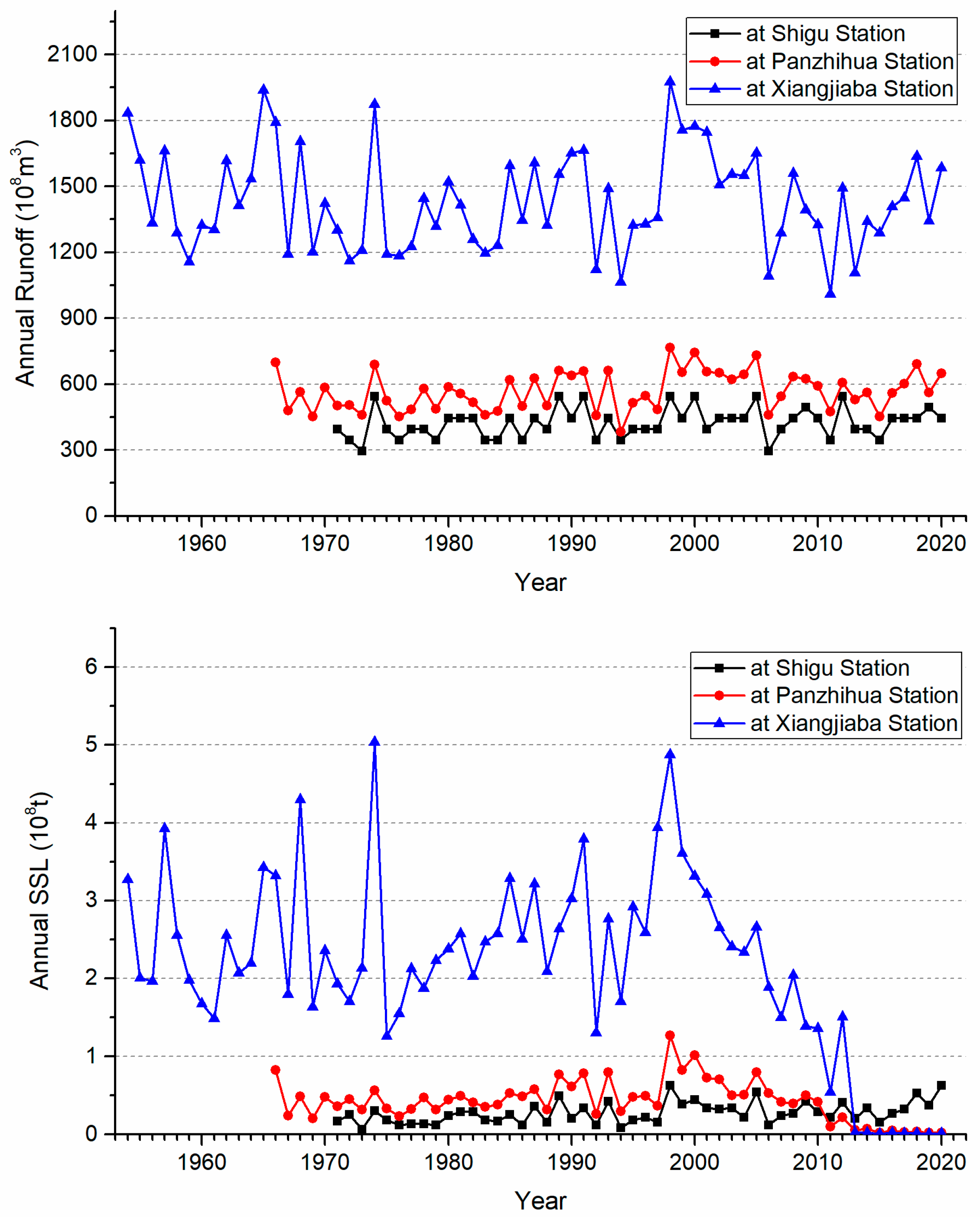
In the whole time series, the annual runoff of the Shigu, Panzhihua, and Xiangjiaba Stations on the mainstream of the Jinsha River ranges from 29.64 billion m3/a to 54.35 billion m3/a, 38.34 billion m3/a to 76.68 billion m3/a, and 101.0 billion m3/a to 197.69 billion m3/a (Figure 2), respectively, while the annual mean runoff is 42.29 billion m3/a, 56.97 billion m3/a, and 143.5 billion m3/a, respectively. The positive Z value obtained by the Mann–Kendall method for the runoff at Shigu Station passed the 95% confidence test, while the value for the runoff of Panzhihua Station passed the 90% confidence test, indicating a significant and inapparent increasing trend, respectively (Table 2). In comparison, the annual runoff and its fluctuation amplitude for Xiangjiaba Station are much larger than those of the first two hydrological stations (Figure 2). A small positive Z value for the runoff at Xiangjiaba Station did not pass the 90% confidence test, indicating an extremely insignificant growth trend (Table 2).
The annual SSL at the abovementioned hydrological stations ranges from 6.8 to 62.9 million t/a, 2.0 to 126.9 million t/a, and 0.6 to 503.6 million t‧yr−1, respectively (Figure 2). The mean annual SSL at the stations is 27.6, 43.1, and 217.2 million t‧yr−1, respectively. The annual SSL at Shigu Station in the time period from 1960 to 2020 generally showed an increasing trend, with the maximum value of 63 million t‧yr−1 occurring in 1998 and 2020. The annual SSL at Panzhihua Station showed an increasing trend in the time period from 1966 to 1998, with a variation range from 21 to 127 million t‧yr−1 and an average annual value of 47.7 million t‧yr−1. It has significantly decreased since 1998, with a variation range from 127 to 2 million t‧yr−1 and an average annual value of 36.3 million t‧yr−1. Particularly since 2003, it has reached a very low value, with a variation range from 7 to 2 million t‧yr−1 and a mean annual value of 2.6 million t‧yr−1 (Figure 2). The annual SSL at Xiangjiaba Station showed significant fluctuations before 1995, with no significant trend of change. The variation range was 149 to 504 million t‧yr−1, with a mean annual value of 245.7 million t‧yr−1. In the time period from 1995 to 1998, there was a significant trend of increase, with a variation range of 126 to 488 million t‧yr−1 and an average annual value of 358.3 million t‧yr−1. In the time period from 1998 to 2012, it showed a significant decreasing trend, with a variation range of 488~2 million t‧yr−1 and an average annual value of 234.5 million t‧yr−1. Since 2013, it has shown a low value and low fluctuation, with a variation range from 0.7 to 2 million t‧yr−1 and a mean annual value of only 1.5 million t‧yr−1. The average annual SSL at the Xiangjiaba Station in the time periods from 1954 to 1998, 1998 to 2020, 1954 to 2012, 2013 to 2020, and 1954 to 2020 were 256, 188, 246, 1.5, and 217.2 million t‧yr−1, respectively.
The Mann–Kendall trend analysis showed that the Z value for the annual SSL of the Shigu Station is positive and passed the 99% confidence test (Table 1), indicating that the interannual variation in the SSL at the station has a significant increasing trend in general. The Z values for the annual SSL of Panzhihua Station and Xiangjiaba Station are both negative and passed the 95% and 99% confidence tests, respectively, indicating that the interannual variation in the SSL at the stations has a decrease and significant decrease trend, respectively.

3.2. Variations in Sediment Concentration and Coefficient of Incoming Sediment

Sediment concentration is a hydrological parameter that connects the sediment transport capacity and water discharge. Understanding the changes in sediment concentration can help reveal the characteristics of sediment transport in rivers.
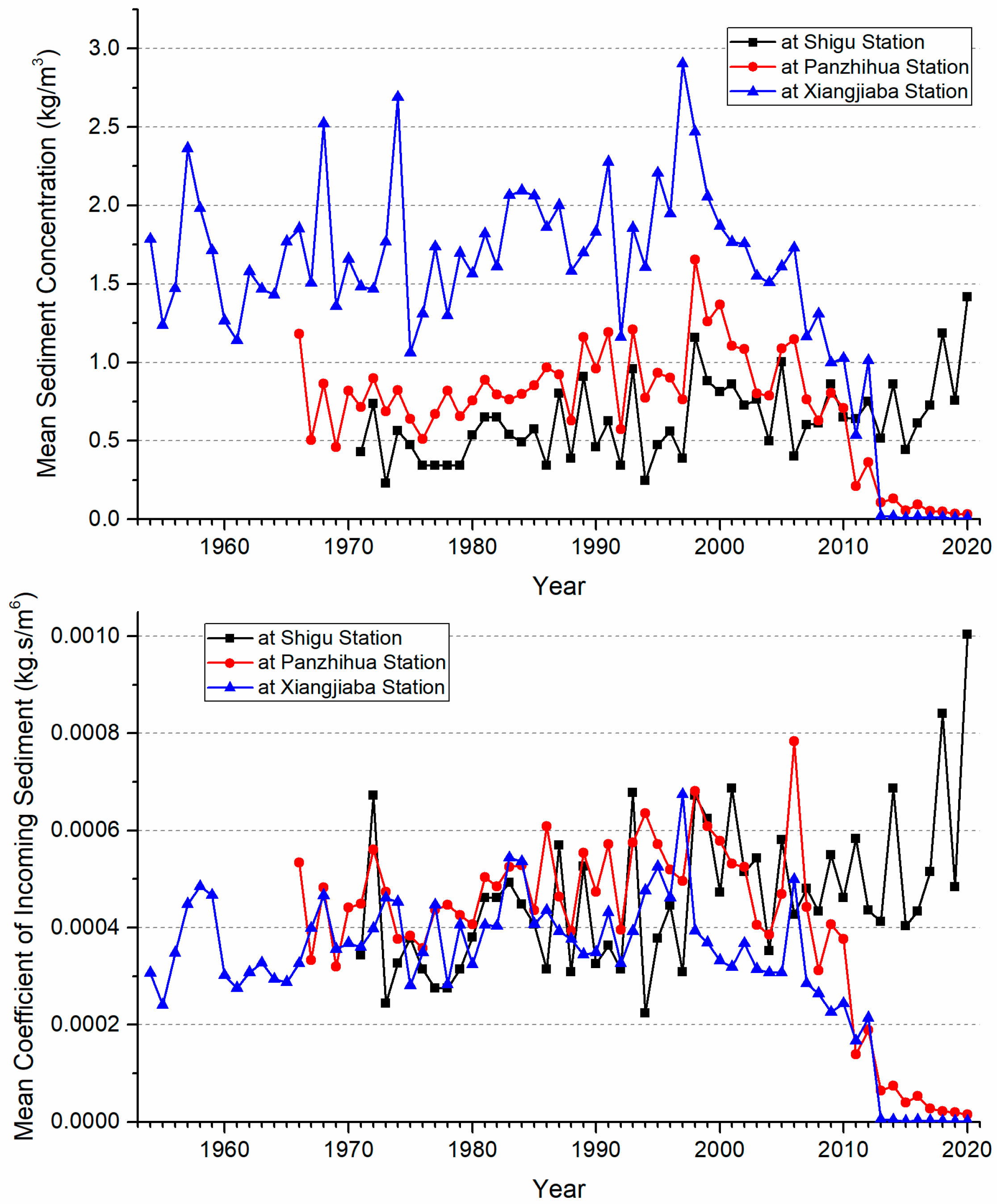
The variation ranges of the annual mean sediment concentration at the Shigu, Panzhihua, and Xiangjiaba Hydrological Stations during their respective investigation periods are 0.23 to 1.42 kg/m3, 0.03 to 1.66 kg/m3, and 0.005 to 2.90 kg/m3, respectively. The mean annual sediment concentration of each station is 0.63 kg/m3, 0.74 kg/m3, and 1.48 kg/m3, respectively. The interannual variation in the mean annual sediment concentration of the three abovementioned hydrological stations is roughly similar to their respective annual SSL (Figure 2 and Figure 3), but there are also specific differences. In general, the sediment concentration of the three hydrological stations showed an increasing trend in fluctuations before 1998. After 1998, except for Shigu Station, which still showed a large fluctuation, the sediment concentration of Panzhihua and Xiangjiaba Stations showed a significant decreasing trend, especially in the very low value since 2013, when the mean sediment concentration of the two hydrological stations was 0.07 kg/m3 and 0.01 kg/m3, which only account for 9.5% and 0.7% of their annual mean sediment concentration in the entire period, respectively.
The CIS is the ratio of mean sediment concentration (unit: kg/m3) to mean water discharge (m3/s) for stream flow during the same period, which corresponds to the sediment concentration in specific water discharge [47]. This facilitates the quantitative comparison of the sediment transport capacity of river sections between different rivers and hydrological stations. The variation ranges of the annual mean CIS of the three hydrological stations during their respective investigation periods are 0.000224 to 0.001 kg‧s/m6, 0.000016 to 0.00078 kg‧s/m6, and 0.000001 to 0.00067 kg‧s/m6, respectively. The interannual mean CIS values at the three stations are 0.00046 kg‧s/m6, 0.00041 kg‧s/m6, and 0.00033 kg‧s/m6, respectively.
From the interannual variation characteristics, the CIS of the three hydrological stations both share similarities and have differences with each other (Figure 3). Prior to 1998, the interannual variation in the CIS for the three stations all showed an increasing trend, with a mean value of 0.00040 kg‧s/m6, 0.00048 kg‧s/m6, and 0.00039 kg‧s/m6, respectively. The difference among the mean CIS is not significant. After 1998, the CIS at the three stations began to behave differently. The CIS at Shigu Station was still increasing in fluctuation, and its average became 0.00054 kg‧s/m6. However, the CIS showed a significant decrease at Panzhihua and Xiangjiaba Stations, with the average values becoming 0.00029 kg‧s/m6 and 0.00019 kg‧s/m6, respectively. Particularly since 2012, the CIS at Panzhihua and Xiangjiaba Stations has decreased to a very low value. The average values dropped to 0.00004 kg‧s/m6 and 0.0000026 kg‧s/m6, accounting for 9.8% and 0.8% of their average values in the entire period, respectively.

3.3. Inflection Point Analysis of Water and Sediment Processes

When using the Mann–Kendall method to detect a sudden change point, if the curves UFk and UBk intersect within the significance level of ɑ = 0.05 (−1.96 < UFk or UBk < 1.96), and the trend after the intersection of the curves does not reverse, then the point is considered a sudden change point. The single variable sudden change detection results of annual runoff and annual SSL at the three hydrological stations are shown in Figure 4. The sudden change in annual runoff is reflected in the Panzhihua Hydrological Station, with the sudden change year being 1985. The other intersections of the runoff sudden change detection curves UFk and UBk involving these hydrological stations are not sudden change points because the trend quickly reversed. The abrupt change in the annual SSL occurred in 1997 at Shigu Station, in 2017 at Panzhihua Station, and in 2012 at Xiangjiaba Station.
The results of sudden change analysis using the double cumulative curve method are shown in Figure 5. It can be found that the scattered points of the cumulative runoff and cumulative SSL have obvious inflection points, which are the intersections of the linear fitting lines for the adjacent time period. Each inflection point reflects a change in the slope of the linear relationship between accumulated water and sediment before and after the year it is located, thereby reflecting a change in the quantitative relationship between annual runoff and sediment transport. In the case of the selected time series, there are two sudden changes at Shigu Station, namely 1979 and 1997. The sudden change years are 1988 and 2009 at Panzhihua Station and 2012 at Xiangjiaba Station. Because this method comprehensively considers two variable factors of runoff and SSL, it is not completely consistent with the sudden change point detected by the abovementioned Mann–Kendall method. However, the inflection years of the SSL at Shigu and Xiangjiaba Stations obtained using this method are 1997 and 2012, respectively, which are completely consistent with the sudden change years detected using the Mann–Kendall method.
It can be seen from the characteristics of the double cumulative curves (Figure 5) that the water–sediment relationship at Shigu Station has undergone two abrupt changes in the time period from 1971 to 2020, and the sudden change occurred in 1980 and 1998, respectively. The slope of the fitted lines between the cumulative runoff and SSL in the 1970s, 1980–1997, and 1998–2020 was 0.0425, 0.059, and 0.072, respectively, showing an increasing trend. This indicates that the cumulative SSL increased faster than the cumulative runoff at Shigu Station in the latter two periods.
The relationship between water and sediment at Panzhihua Station also experienced sudden changes twice during the time period from 1966 to 2020, but the sudden change years were 1989 and 2010. The two inflection years can be used to divide the entire period into three different time sub-periods: 1966–1988, 1989–2009, and 2010–2020 (Figure 5). The slopes of the fitted lines between the cumulative runoff and SSL in the sub-periods were 0.00076, 0.00106, and 0.000104, respectively. This indicates that the growth rate of cumulative sediment transport and runoff at the station significantly increased in the sub-period from 1989 to 2009, while they significantly decreased in the sub-period from 2010 to 2020 compared with the former sub-period.
During the time period from 1954 to 2020, the relationship between cumulative runoff and SSL at Xiangjiaba Station only experienced a significant sudden change in 2012, which can be used to divide the entire period into two sub-periods of 1954–2011 and 2012–2020 (Figure 5). The slopes of the fitted lines in the two sub-periods were 0.00179 and 0.0000107, respectively. This indicates that the growth rate of the cumulative SSL in the later sub-period was much smaller than that in the former sub-period at Xiangjiaba Station.

3.4. Variation in the Relationship between Water and Sediment

The relationship between cumulative runoff and SSL can reflect the characteristics of the relationship between water and sediment in the cumulative state year by year. Since the cumulative value in the later period is far greater than the actual value in the corresponding years, this kind of relationship only reflects the changing trend of the water and sediment processes and indicates the possible sudden change time and does not represent the true relationship between water and sediment changes. Based on the results obtained by the Mann–Kendall sudden change detection method and the double cumulative curve method for the water and sediment processes at Panzhihua and Xiangjiaba Stations, and considering the need for easy comparison of the corresponding data, it is comprehensively concluded that the sudden change years of the water and sediment data series at these two hydrological stations are 1998 and 2012. On this basis, further analysis is needed of the actual fitting relationship between the annual runoff and SSL of these two hydrological stations in the different sub-periods divided by the two inflection years mentioned above.
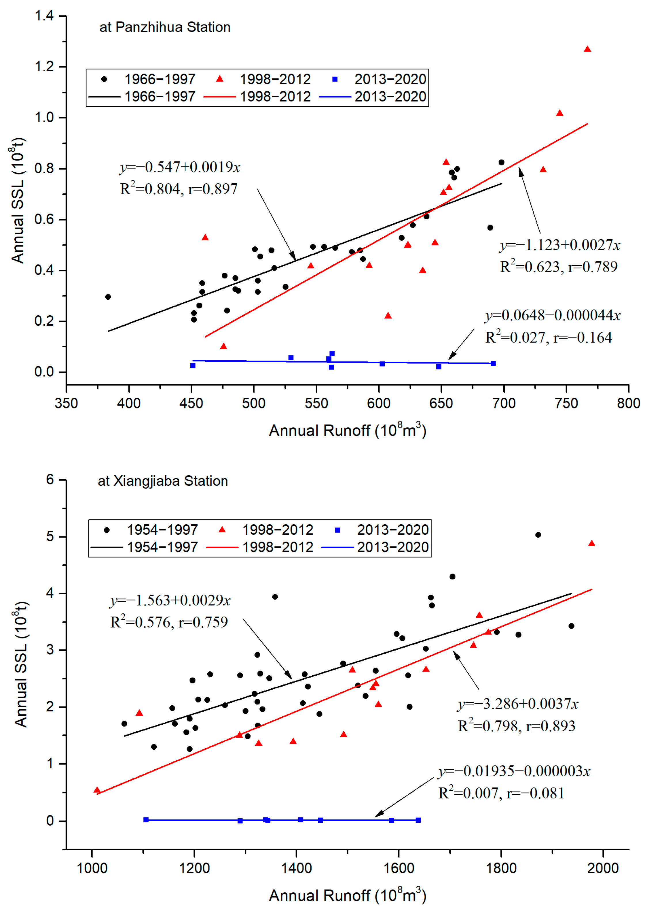
The fitted linear relationships between annual runoff and SSL (Figure 6) show that the slopes of the fitted lines at Panzhihua and Xiangjiaba Stations before 1998 were 0.0019 and 0.0029, with correlation coefficients of 0.897 and 0.759, respectively. This indicates that the annual transported suspended sediment at Xiangjiaba and Panzhihua Stations increases with the increase in annual runoff, and the growth rate is greater at Xiangjiaba Station than at Panzhihua Station.
During the sub-period from 1998 to 2012, the slopes of the fitted lines at these two stations were 0.0027 and 0.0037, with correlation coefficients of 0.0.789 and 0.893, respectively. This also indicates that the annual SSL at Xiangjiaba and Panzhihua Stations increases with the increase in annual runoff, with the former having a greater growth rate than the latter. At the same time, the slope of the same station also significantly increases compared to that in the previous sub-period. These phenomena reveal that the ratio of annual yield suspended sediment to annual yield runoff in the river sub-basins above the given hydrological stations has increased during this period compared to the previous period; that is, the sediment concentration and CIS have increased compared to that in the previous period.
After 2012, the slopes of the fitted lines for the two abovementioned stations are −0.000044 and −0.000003, respectively, showing a very weak negative correlation compared to the past. The slope values are very close to 0, which indicates that there is almost no relationship between annual runoff and SSL, which means that sediment transport is very small and almost unrelated to changes in runoff, especially for Xiangjiaba Station. This indicates that compared to the previous two sub-periods, the changes in the water–sediment relationship since 2012 have significant uniqueness and do not follow the inherent laws of natural water-sediment processes but are severely controlled by human factors beyond the natural factors of the river basin.

4. Discussion

4.1. Dam Construction and the Years of Sharply Increasing Storage Capacity

The Jinsha River Basin, whether the mainstream or the main tributary, the Yalong River, has abundant water volume and a high channel gradient, so it has huge potential for hydropower development. Reservoir construction in the Jinsha River Basin for the purpose of producing clean energy has been going on for many years, and the earliest reservoir construction started in the 1960s. However, due to various objective conditions, both the capacity of the reservoir and the quantity of construction were very limited. With the advancement of dam construction technology and building material production technology, additional larger reservoirs are being built one by one (Table 1). In particular, the four cascade reservoirs, Wudongde, Baihetan, Xiluodu, and Xiangjiaba, in the lower reach of Jinsha River were completed in 2020, 2021, 2013, and 2012, respectively, and this river has become a fully dam-controlled reach. Figure 7 shows that the periods of significant increase in storage capacity of large reservoirs in the Jinsha River Basin were 1998, 2011–2015 (especially 2013), and 2020–2021.
From the 1960s to 2015, there were 22 large reservoirs (with a storage capacity of ≥100 million m3), 108 medium reservoirs (with a storage capacity ranging from 10 to 100 million m3), and 2537 small reservoirs (with a storage capacity of <10 million m3) built in the Jinsha River Basin [38]. The cumulative total storage capacity of the large, medium, and small reservoirs is 42.92 billion m3, 2.481 billion m3, and 1.638 billion m3, respectively. The total storage capacity of these three types of reservoirs is 47.039 billion m3 [38]. The total storage capacity of the three types of reservoirs accounts for 91.24%, 5.27%, and 3.48% of the total storage capacity of all reservoirs, respectively. Until 2021, with the completion of the Wudongde and Baihetan reservoirs, the storage capacity of the large reservoirs in the Jinsha River Basin has increased to 70.92 billion m3, accounting for 94.5% of the total storage capacity of various reservoirs. Obviously, although the total number of large reservoirs is the lowest of the different types, their total storage capacity represents an absolute advantage. A series of reported studies have shown (e.g., [28,29,31,33,37,38,42]) that the constructed large reservoirs, as a major indicator of human activities, have become the most important influencing factor in SSL change of the Jinsha River.
Large reservoirs, due to their large storage capacity, can effectively store a large amount of water. They can turn the water flow from the upstream river of the reservoir with normal river flow velocity into low-speed water flow or even result in a static water body for a large amount or a longer duration. As a result, due to the significant decrease in water flow velocity in the reservoir area, the suspended sediment carried by river flow is heavily deposited, resulting in a significant decrease in sediment concentration. The SSL in the river section below the reservoir dam has also significantly decreased. If a small reservoir is built at the same dam site, the amount of water it can effectively retain is limited, and the water flow from the upstream river channel with normal flow velocity can be transformed into a water body with lower flow velocity or a static flow state, and its duration is relatively limited. Therefore, the amount of suspended sediment that can be deposited in the small reservoir area due to a decrease in flow velocity is also relatively limited, resulting in a limited decrease in sediment concentration in the downstream flow section below the dam. The decrease in SSL at the river section below the dam is also not significant. For the same reason, the decrease in sediment concentration and sediment transport in the downstream river section of medium-sized reservoirs built at the same dam site is intermediate.
The interannual distribution of the storage capacity and cumulative storage capacity of the large reservoirs built in the river reaches above Shigu, Panzhihua, and Xiangjiaba Stations of the Jinsha River is shown in Figure 7. It can be seen that only a large reservoir with a storage capacity of 300 million m3 (Mangcuohu Reservoir, located in Cuolongmenqu, a tributary of the Jinsha River) was built in the river reach above Shigu Station in 2003 (Table 1), and its control area only accounts for 0.057% of the total drainage area above Shigu Station. The reservoir has no obvious impact on the sediment transport process at Shigu Station. Therefore, the change in the SSL at Shigu Station is basically affected by natural factors.
In the river reach above Panzhihua Station, in addition to the Mangcuohu Reservoir, the Jinanqiao Reservoir and Buxi Reservoir (with a total storage capacity of 910 million m3 and 250 million m3, respectively) were built in 2011, Ahai, Longkaikou, the Ludila Reservoirs (with a total storage capacity of 890 million m3, 560 million m3, and 1.72 billion m3, respectively) were built in 2014, and the Liyuan and Guanyinyan Reservoirs (with a total storage capacity of 810 million m3 and 2.25 billion m3, respectively) were built in 2015 (Table 1). The total storage capacity of the reservoirs built in 2011, 2014, and 2015 is 1.16 billion m3, 3.17 billion m3, and 3.06 billion m3, respectively. These reservoirs are the main control factors affecting the significant reduction in SSL at Panzhihua Station below the normal fluctuation range.
In the river reach above Xiangjiaba Station, in addition to the aforementioned reservoirs, additional larger reservoirs have been built. Among them, Ertan was built in 1998, and the Xiangjiaba and Jinpingyiji Reservoirs began to store water in 2012 and 2013, respectively. Wudongde and Baihetan Reservoirs were built in 2020 and 2021, respectively (Table 1). The total storage capacity of these reservoirs (Ertan, Xiangjiaba, Jinpingyiji, Xiluodu, Wudongde, and Baihetan) is 5.8 billion m3, 5.16 billion m3, 7.76 billion m3, 16.27 billion m3, 7.4 billion m3, and 20.6 billion m3, respectively. The year when the storage capacity of large reservoirs built in the Jinsha River Basin increased sharply is also the year when the SSL at Xiangjiaba Station began to decrease sharply (Figure 7 and Figure 8). From this, it can be seen that the sediment retention of large reservoirs in the research area is the fundamental reason for the significant reduction in the SSL at the cross-section after dam construction.

4.2. Impact of Reservoirs on Water and Sediment Processes

The annual SSL at Xiangjiaba Station of the Jinsha River has obviously decreased since 1998, especially since 2013. The mean annual SSL in the period from 2013 to 2020 only accounted for 0.61% of the mean annual SSL in the period from 1954 to 2012. The annual SSL at Panzhihua Station has significantly decreased since 2003 and has also sharply decreased since 2013. The mean annual SSL in the periods from 1998 to 2020 and from 2003 to 2020 accounted for 76.1% and 5.5% of that in the period from 1966 to 1998, respectively. The two key time nodes of 1998 and 2013 coincide with the time point when the storage capacity of large reservoirs in the Jinsha River Basin increased significantly (Figure 7). The increase in the storage capacity of large reservoirs in the Jinsha River Basin and the interannual variation in their cumulative storage capacity (Figure 7) show that the Ertan Reservoir, built near the end of the Yalong River in 1998, controls a drainage area of 116,400 km2, and its storage capacity is 5.8 billion m3 (Table 1), which accounts 63.8% of the total storage capacity (9.09 billion m3) of all nine large reservoirs built in the Jinsha River Basin before 2013. The mean annual SSL of the Yalong River is 45 million t yr−1, accounting for 20.7% of that at Xiangjiaba Station. After the completion of the Ertan Reservoir, the mean annual suspended sediment detention is 315 million t yr−1, accounting for 70.1% of that transported by the Yalong River on average [42]. This is the main reason why the annual SSL at Xiangjiaba Station has decreased significantly since reaching the maximum in 1998. However, the annual SSL at Panzhihua Station was generally in a high range between 1998 and 2006, which can partially offset the decrease in the annual SSL at Xiangjiaba Station caused by the sediment interception of the Ertan Reservoir. It can be seen that although the sediment detention rate of the Ertan Reservoir in the Yalong River Basin is very high, its annual sediment detention volume only accounts for 14.5% of the annual sediment discharge at Xiangjiaba Station. Therefore, the construction of the Ertan Reservoir has not caused a sudden change in the annual sediment discharge of Xiangjiaba Station.
Two, three, and two large reservoirs were built in the middle reach (between Shigu and Panzhihua Stations) of the Jinsha River mainstream in 2011, 2014, and 2015, respectively (Figure 7). The total storage capacity in the different three years was 1.16 billion m3, 3.17 billion m3, and 3.06 billion m3, respectively. This is the key human influence factor leading to the sharp decrease in SSL at Panzhihua Station after 2012, and it is also the basic influence factor promoting the sharp decrease in sediment transport at Xiangjiaba Station. Xiangjiaba Reservoir at the outlet of Jinsha River and Xiluodu Reservoir adjacent to its upstream began to store water in 2012 and 2013, respectively, with a storage capacity of 5.16 billion m3 and 12.67 billion m3, respectively. The phased water storage and long-term sediment retention of the reservoirs with huge storage capacity have extremely high capability, which is the fundamental reason for the sharp reduction in SSL to a very low value at Xiangjiaba Station since 2012.
After the completion of the dams, the reservoir has a very high sediment retention capacity, but the impact on runoff mainly manifests as seasonal changes and the overall impact on changes in runoff over a longer time scale (several years or more) is limited. The mean annual SSL of the Jinsha River Basin during the period from 1954 to 2011 was 246 million tons yr−1. Assuming an average dry density of 1.5 tons/m3 [48], the total volume of annual sediment transport is 164 million m3. If all of this sediment were intercepted by the Baihetan Reservoir or Xiangjiaba Reservoir, it would take 126 or 31 years for the sediment to fill the reservoir, respectively. Of course, considering the cascade distribution of the large reservoirs along the mainstream and tributaries and the sediment deposition of each reservoir, the sediment retention life of these large reservoirs is much longer than 30 years. Obviously, the sediment retention function of these reservoirs will be maintained for at least several decades. Therefore, these reservoirs will also have long-term impacts on the sediment transport in corresponding river reaches.
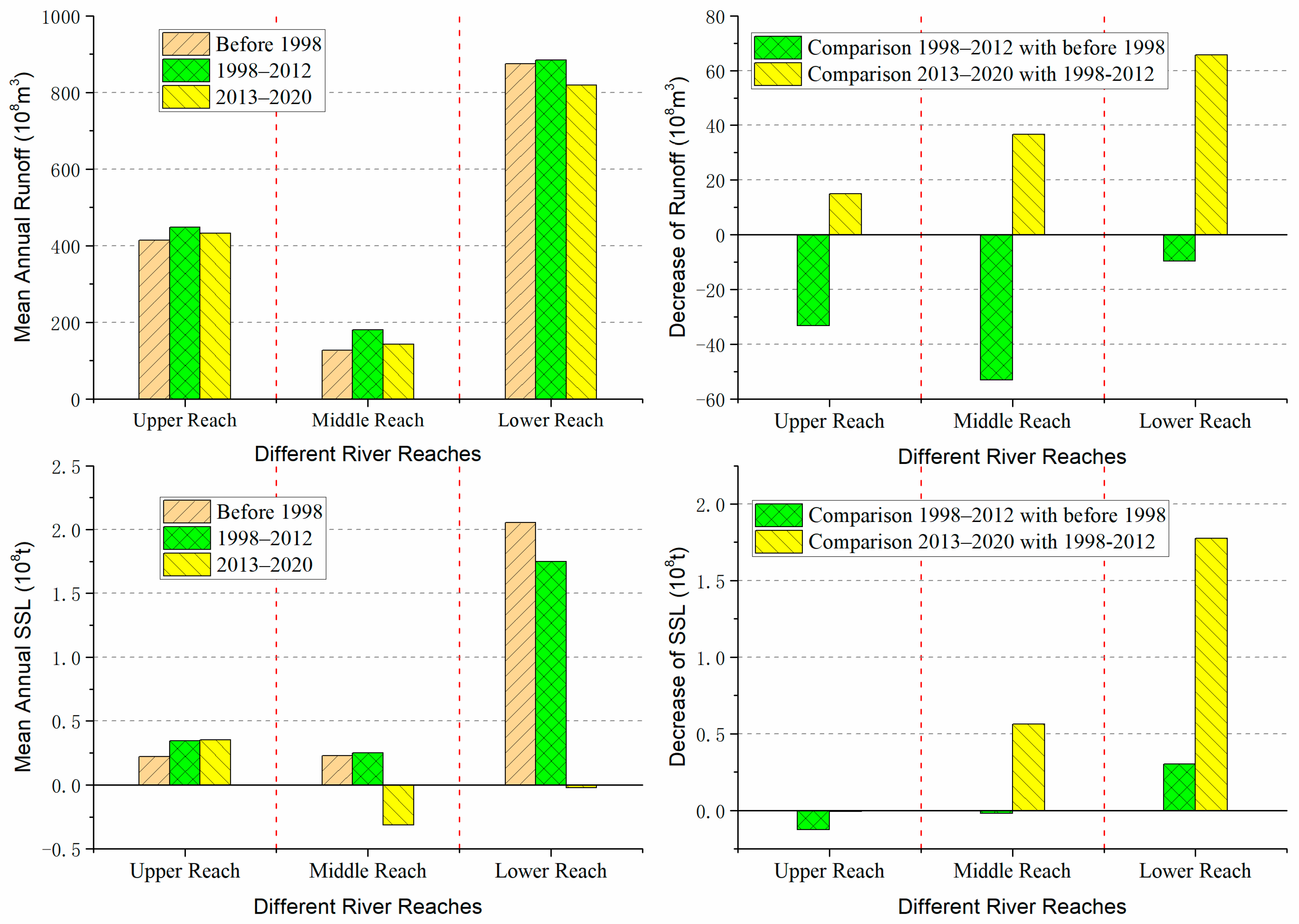
The above mainly discussed the impact of large reservoirs on runoff and sediment transport in each basin above a given hydrological station. The following will briefly discuss the changes in water and sediment in different river reaches between given hydrological stations and their responses to reservoir construction. Figure 9 shows that before and after the period when a large number of large reservoirs were built, the variation in runoff was not significant for a given cross-section or river section downstream of the dam, but the SSL decreased sharply. Compared with that before 1998, the mean annual runoff of the upper, middle, and lower reaches of the Jinsha River increased in the period from 1998 to 2012, with increase rates of 8.0%, 41.9%, and 1.1%, respectively, while in the period from 2013 to 2020, there was a slight decrease, with reduction rates of 3.6%, 28.9%, and 7.5%, respectively. The mean annual SSL in the three river reaches decreased by −55.9%, −8.3%, and 14.7% in the period from 1998 to 2012, while the values decreased by −3.2%, 244.5%, and 86.5% in the period from 2013 to 2020, respectively. The abovementioned phenomena further indicate that after the completion of a large reservoir, the downstream runoff below its dam will increase or decrease appropriately in annual or decadal time scales, while the SSL will decrease significantly, leading to a significant decrease in the sediment concentration and CIS (Figure 3) and a noticeable change in the relationship between water and sediment (Figure 6).

4.3. Impacts of Climate Fluctuations on Water and Sediment Processes

Climate is one of the key factors affecting the water flow and sediment yield in a watershed. The annual or decadal fluctuations in climate factors such as temperature and precipitation can cause changes in vegetation conditions, including vegetation coverage and abundance of riparian vegetation, runoff generation, confluence capacity, and sediment production, and then cause changes in SSL within the watershed [38,39,40,41,42,43,44,45,46,47,49,50,51,52,53].
In the entire watershed of the Jinsha River, the annual precipitation shows an increasing trend, but it is not significant at the 95% confidence level [54]. Hence, the precipitation variation did not significantly influence the runoff change in the river basin. Without considering other influencing factors, when climate fluctuation was not significant, it generally did not lead to sudden changes in watershed runoff and sediment transport at a certain period in the past. However, the climate fluctuation dominated by warming and humidification in the past decades was likely to have a decisive impact on the increase in annual runoff and SSL in the area above Shigu Station in the Jinsha River Basin.
The source area (above Zhimenda Station with a basin area of 142,000 km2) of the Jinsha River has shown an overall trend of warming and humidifying, especially in the past 20 years, with both increased precipitation and temperature in the source area having an impact on the increase in runoff [55]. Simultaneously, climate warming enhances the melting of glaciers at the source area and expands the melting area of frozen soil layers in the upper river reach. As a result, this further leads to an increase in sediment yield areas and an enhancement in sediment yield capacity. Obviously, climate warming in the source area is a key influencing factor that leads to a significant increase in annual runoff and an extremely significant increase in SSL, sediment concentration, and CIS at Shigu Station. However, changes in climate and underlying surface are not obvious in the lower Jinsha River Basin [56], which are insignificant compared with human activities, especially the construction of large reservoirs that have direct and strong impacts on sediment transport. The huge water storage and sediment retention function of large reservoirs not only changes the sediment transport process but also greatly changes the water and sediment transportation mechanism or hydraulic regime [55,56,57,58]. For example, due to the influence of large reservoirs, the hydrograph of the monthly mean flow and sediment concentration in the lower reach below the Xiaolangdi Reservoir on the Yellow River has changed from the previous clockwise loop to a counterclockwise loop [13]. Similar phenomena may occur in the lower reaches below the reservoirs of the Jinsha River, which is a scientific problem that needs further study in the future.
The overall change in the trend of water and sediment and its main influencing factors obtained in this study is consistent with the reported results (e.g., [28,31,37,38]). Due to the different lengths of the data series used, the inflection years of runoff and sediment transport obtained are not entirely the same but are generally very close. Furthermore, this study also analyzed the trend of changes in sediment concentration and CIS at different spatial scales and confirmed their good synchronization with changes in sediment transport. In contrast to the results of reported studies (e.g., [28,29,31,32,33,37,38,39,40,41,42]), this study reveals the sudden changes in runoff and sediment transport in different regions of the Jinsha River Basin. It recognizes that there are significant regional differences in the main controlling factors of water and sediment changes in the river basin. At the same time, it was revealed that there is excellent temporal consistency between the inflection years of annual SSL and the years when the capacity of the completed reservoir significantly increases. These findings can provide a basis for explaining the interannual change and regional differences in sediment transport in the Jinsha River Basin.

5. Conclusions

Based on a long time series of water and sediment data at Shigu, Panzhihua, and Xiangjiaba Hydrological Stations, the runoff and sediment transport processes in different regions of the Jinsha River Basin were analyzed, and the impact of large reservoirs was discussed. The main conclusions are as follows:
  • The variation in annual runoff at Shigu Station shows a significant trend of increasing, while that at Panzhihua and Xiangjiaba Stations shows an insignificant increase trend at significance level ɑ = 0.05. The interannual variation in runoff at Panzhihua Station has an inflection year of 1985, which was not found for the other stations;
  • There are obvious stages and regional differences in the variation in sediment transport in the Jinsha River Basin. The annual suspended sediment load (SSL) at Shigu Station shows a fluctuating increasing trend. At Panzhihua Station, it shows a trend of increasing before 1998 and decreasing since 1998. The annual SSL at Xiangjiaba Station fluctuated significantly and did not show any obvious change trend before 1998 and has had a significant decreasing trend since 1998. Particularly since 2013, it only accounted for 0.61% of its multi-year average. The interannual variation in sediment concentration and coefficient of incoming sediment (CIS) at the stations is consistent with the change in the SSL. The annual mean sediment concentration increases along the river course, indicating a trend of increasing sediment yield modulus along the river course. The different change trends of water and sediment for Panzhihua and Xiangjiaba Stations led to a significant change in the correlation between annual runoff and SSL ranging from strong (R2 ranged of 0.58 and 0.80) before 2012 to extremely poor (R2 less than 0.03) since 2013;
  • In the Jinsha River Basin, there is high consistency between the years when the SSL began to decrease sharply and the years when the capacity of the large reservoir rapidly increased. Therefore, the large amount of sediment retention in the large reservoirs can be considered the key reason for the sharp decrease in annual SSL at the Panzhihua and Xiangjiaba Stations. Climate warming and increasing precipitation caused an increase in runoff and SSL in the river reach above Shigu Station, especially in the source area of the Jinsha River, but their impact on the water and sediment changes in the middle and lower reaches was limited;
  • Against the backdrop of massive sediment retention in reservoirs, in the future, it is possible to consider dispersing and depositing sediment from the watershed as reasonably as possible in different cascade reservoirs, thereby extending the operational life of the reservoirs. In addition, research can be conducted on the micro landform and regional differentiation characteristics of sediment grain size at the bottom of the reservoir in order to understand the potential impact of underwater topography on aquatic habitats.

Author Contributions

Conceptualization, S.W.; Formal Analysis, X.W. and S.W.; Draft Preparation, X.W. and S.W.; Review and Editing, S.W. All authors have read and agreed to the published version of the manuscript.

Funding

This research was funded by the National Key Research and Development Program of China (Grant No. 2022YFC3203903) and the National Natural Science Foundation of China (Grant No. 41971004).

Data Availability Statement

Data can be accessed through personal contact.

Acknowledgments

The authors thank the Yangtze River Water Conservancy Committee and the Hydrological Bureau of the Ministry of Water Resources of the People’s Republic of China for permission to access the hydrological gauging data. We would like to thank the anonymous referees for providing us with constructive comments and suggestions on the earlier version of this paper.

Conflicts of Interest

The authors declare no conflict of interest.

References

  1. Walling, D.E. The Impact of Global Change on Erosion and Sediment Transport by Rivers: Current Progress and Future Challenges; UNESCO: Paris, France, 2009. [Google Scholar]
  2. Milliman, J.D.; Farnsworth, K.L. River Discharge to the Coastal Ocean: A Global Synthesis; Cambridge University Press: Cambridge, UK, 2011. [Google Scholar]
  3. Walling, D.E.; Fang, D. Recent trends in the suspended sediment loads of the world’s rivers. Glob. Planet. Chang. 2003, 39, 111–126. [Google Scholar] [CrossRef]
  4. Wang, S.; Hassan, M.A.; Xie, X. Relationship between suspended sediment load, channel geometry and land area increment in the Yellow River delta. Catena 2006, 65, 302–314. [Google Scholar] [CrossRef]
  5. Walling, D.E. Human impact on land-ocean sediment transfer by the world’s rivers. Geomorphology 2006, 79, 192–216. [Google Scholar] [CrossRef]
  6. Lu, Z. Watershed Geomorphological System; Dalian Publishing House: Dalian, China, 1991. (In Chinese) [Google Scholar]
  7. Wang, S.; Ni, J.; Wang, G. Sedimentary system analysis of the evolution model of channel patterns in ancient river systems and influencing factors. Pet. Explor. Dev. 2000, 27, 102–105. [Google Scholar]
  8. Lin, C. Sediment and River Geomorphology; Nanjing University Press: Nanjing, China, 1992. (In Chinese) [Google Scholar]
  9. Qian, N.; Zhang, R.; Zhou, Z. Channel Processes; Science Press: Beijing, China, 1987. (In Chinese) [Google Scholar]
  10. Xu, J. Geomorphological Processes of the Yellow River; Science Press: Beijing, China, 2012. (In Chinese) [Google Scholar]
  11. Wang, S. The Erosion and Sedimentation Rate and Evolution Mechanism in Ningmeng Reaches of the Yellow River; China Environmental Publishing Group: Beijing, China, 2022. (In Chinese) [Google Scholar]
  12. Wang, S.; Yan, M.; Yan, Y.X.; Shi, C.; He, L. Contributions of climate change and human activities to the changes in runoff increment in different sections of the Yellow River. Quat. Int. 2012, 282, 66–77. [Google Scholar] [CrossRef]
  13. Wang, S.; Wang, X. Changes of water and sediment processes in the Yellow River and their responses to ecological protection during the last six decades. Water 2023, 15, 2285. [Google Scholar] [CrossRef]
  14. Miao, C.; Ni, J.; Borthwick, A.G.L.; Yang, L. A preliminary estimate of human and natural contributions to the changes in water discharge and sediment load in the Yellow River. Glob. Planet. Chang. 2011, 76, 196–205. [Google Scholar] [CrossRef]
  15. Walling, D.E. The role of dams in the global sediment budget. In Erosion and Sediment Yields in the Changing Environment; Collins, A.L., Golosov, V., Horowitz, A.J., Lu, X., Stone, M., Walling, D.E., Zhang, X., Eds.; International Association of Hydrological Science. IAHS Publication: Wallingford, CT, USA, 2012; pp. 3–11. [Google Scholar]
  16. Wang, S.; Liu, W.; Yan, M.; He, L. Stepped changes in suspended sediment transport efficiency and discharge ratio and the main causes in the lower reach of the Yellow River. Res. Soil Water Conserv. 2020, 27, 104–111. (In Chinese) [Google Scholar]
  17. Wang, S.; Wang, Y.; Ran, L.; Su, T. Climatic and anthropogenic impacts on runoff changes in the Songhua River basin over the last 56 years (1955–2010), Northeastern China. Catena 2015, 127, 258–269. [Google Scholar] [CrossRef]
  18. Brandt, S.A. Classiffcation of geomorphological effects downstream of dams. Catena 2000, 40, 375–401. [Google Scholar] [CrossRef]
  19. Syvitski, J.P.; Vörösmarty, C.J.; Kettner, A.J.; Green, P. Impact of humans on the flux of terrestrial sediment to the global coastal ocean. Science 2005, 308, 376–380. [Google Scholar] [CrossRef] [PubMed]
  20. Graf, W.L. Downstream hydrologic and geomorphic effects of large dams on American rivers. Geomorphology 2006, 79, 336–360. [Google Scholar] [CrossRef]
  21. Thomson, K.D.; Stockli, D.F.; Fildani, A. Anthropogenic impact on sediment transfer in the upper Missouri River catchment detected by detrital zircon analysis. Geol. Soc. Am. Bull. 2022, 134, 2485–2502. [Google Scholar] [CrossRef]
  22. Kondolf, G.M. PROFILE: Hungry Water: Effects of Dams and Gravel Mining on River Channels. Environ. Manag. 1997, 21, 533–551. [Google Scholar] [CrossRef] [PubMed]
  23. Schmidt, J.C.; Wilcock, P.R. Metrics for assessing the downstream effects of dams. Water Resour. Res. 2008, 44, W04404. [Google Scholar] [CrossRef]
  24. Rossi, A.; Massei, N.; Laignel, B.; Sebag, D.; Copard, Y. The response of the Mississippi River to climate fluctuations and reservoir construction as indicated by wavelet analysis of streamflow and suspended–sediment load, 1950–1975. J. Hydrol. 2009, 377, 237–244. [Google Scholar] [CrossRef]
  25. Hu, C.; Wang, Y.G.; Zhang, Y.J.; Shi, H. Variation tendency of runoff and sediment load in China major rivers and its causes. Adv. Water Sci. 2010, 21, 524–532. (In Chinese) [Google Scholar]
  26. Zhao, G.; Mu, X.; Strehmel, A.; Tian, P. Temporal variation of streamflow, sediment load and their relationship in the Yellow River Basin, China. PLoS ONE 2014, 9, e91048. [Google Scholar] [CrossRef]
  27. Wang, Y.; Hu, C.; Liu, X.; Shi, H. Study on variations of runoff and sediment load in the Upper Yangtze River and main influence factors. J. Sediment Res. 2016, 1, 1–8. (In Chinese) [Google Scholar] [CrossRef]
  28. Lu, C.; Dong, X.; Tang, J.; Liu, G. Impacts of large cascade reservoirs on runoff and sediment load variations in Jinsha River Basin. Sci. Soil Water Conserv. 2019, 17, 36–43. (In Chinese) [Google Scholar]
  29. Chen, K.; Liu, C. The impact of human activities on the variation of water and sediment conditions in the upper reaches of the Yangtze River. China Rural. Water Hydropower 2021, 126–131. Available online: https://kns.cnki.net/kcms2/article/abstract?v=3uoqIhG8C44YLTlOAiTRKibYlV5Vjs7iy_Rpms2pqwbFRRUtoUImHVmBw4YQ5xm27ix4viiCZrhAyPkxk7kZkqYNQFrZ9LAM&uniplatform=NZKPT (accessed on 10 September 2023). (In Chinese).
  30. Liu, W.; Wang, S.; Sang, Y.; Ran, L.; Ma, Y. Effects of large upstream reservoir operations on cross–sectional changes in the channel of the lower Yellow River reach. Geomorphology 2021, 387, 107768. [Google Scholar] [CrossRef]
  31. Liu, H.C.; Zhang, H.L.; Xia, S.Q.; Pang, J. Runoff and sediment discharge variations and corresponding driving mechanism in Jinsha River Basin. Res. Soil Water Conserv. 2023, 30, 107–115. (In Chinese) [Google Scholar]
  32. Xu, J. Recent variations in water and sediment in relation with reservoir construction in the upper Changjiang River Basin. J. Mt. Sci. 2009, 27, 385–393. (In Chinese) [Google Scholar]
  33. Li, H.B.; Zhang, X.F.; Hu, C.H.; Xu, Q. Impact of cascade reservoirs construction in the upper Yangtze River on sediment inflow to Three Gorges reservoirs. J. Hydroelectr. Eng. 2011, 30, 94–100. [Google Scholar]
  34. Yang, X.; Lu, X.X. Estimate of cumulative sediment trapping by multiple reservoirs in large river basins: An example of the Yangtze River basin. Geomorphology 2014, 227, 49–59. [Google Scholar] [CrossRef]
  35. Duan, Y.C.; Li, D.X.; Wang, X.K. Analysis of the sediment trapping by reservoirs in the Upper Yangtze River. J. Sichuan Univ. (Eng. Sci. Ed.) 2015, 47, 15–23. (In Chinese) [Google Scholar]
  36. Yang, S.L.; Xu, K.H.; Milliman, J.D.; Yang, H.F.; Wu, C.S. Decline of Yangtze River water and sediment discharge: Impact from natural and anthropogenic changes. Sci. Rep. 2015, 5, 12581. [Google Scholar] [CrossRef]
  37. Zhu, L.L.; Dong, X.Y.; Chen, Z.F. Sediment deposition of cascade reservoirs in the Lower Jinsha River and its impact on Three Gorges Reservoir. J. Yangtze River Sci. Res. Inst. 2016, 34, 1–7. (In Chinese) [Google Scholar]
  38. Yuan, J.; Xu, Q.X. Sediment trapping effect by reservoirs in the Jinsha River basin. Adv. Water Sci. 2018, 29, 482–491. (In Chinese) [Google Scholar]
  39. Qin, L.L.; Dong, X.Y.; Du, Z.D.; Chen, X.J. Processes of water–sediment and deposition in cascade reservoirs in the lower reach of Jinsha River. J. Sediment Res. 2019, 44, 24–30. (In Chinese) [Google Scholar]
  40. Zhang, M.; Huang, X.; Wang, Y. Analysis of runoff evolution process and influencing factors in Jinsha River Basin. Water Resour. Power 2022, 40, 27–31. (In Chinese) [Google Scholar]
  41. Feng, S.H.; Wang, D.W.; Qin, L.L.; Deng, A.J.; Xing, L. The characteristics and cause of runoff variation in Jingsha River basin. South-North Water Transf. Water Sci. Technol. 2023, 21, 248–257. (In Chinese) [Google Scholar]
  42. Liu, S.W.; Zhang, X.F.; Xu, Q.X.; Yue, Y. Transport characteristics and contributing factors of suspended sediment in Jinsha River in recent 50 years. J. Sediment Res. 2020, 45, 30–37. (In Chinese) [Google Scholar]
  43. Xi, Y.Y.; Huang, X.R.; Li, J.J. Analysis on variation features of precipitation in Jinsha River basin. Yangtze River 2017, 48, 50–55. (In Chinese) [Google Scholar]
  44. Mann, H.B. Nonparametric tests against trend. Econometrica 1945, 13, 245–259. [Google Scholar] [CrossRef]
  45. Kendall, M.G. Rank Correlation Methods; Charles Griffin and Company Ltd.: London, UK, 1975. [Google Scholar]
  46. Wang, S.; Yan, Y.; Yan, M.; Zhao, X. Quantitative estimation of the impact of precipitation and human activities on runoff change of the Huangfuchuan River basin. J. Geogr. Sci. 2012, 22, 906–918. [Google Scholar] [CrossRef]
  47. Wu, B.S.; Shen, G.Q. Discussion on physical meaning of sediment–coming coefficient. Yellow River 2008, 30, 15–16. (In Chinese) [Google Scholar]
  48. Zhang, Y.; Wang, J. Study on distribution and calculation method of reservoir sediment dry bulk density. J. Sediment Res. 2004, 3, 54–58. (In Chinese) [Google Scholar] [CrossRef]
  49. Lu, L.; Wang, Q.; Wang, G.; Liu, Y.; Liu, C. Trend of climate change over the recent 60 years and its hydrological responses for Jinsha River Basin. J. North China Univ. Water Resour. Electr. Power (Nat. Sci. Ed.) 2016, 37, 16–21. (In Chinese) [Google Scholar]
  50. Shi, W.Y.; Zhang, Z.Y.; Li, Z.Y. Temporal and spatial distribution characteristics of precipitation in Jinsha River Basin in recent 55 years and changing trend. Yangtze River 2016, 47, 39–43. (In Chinese) [Google Scholar]
  51. Wang, G.; Han, L.; Tang, X.Y.; Jin, Z.C. Temporal and spatial variation of vegetation in the Jinsha River basin. Resour. Environ. Yangtze Basin 2012, 21, 1191–1196. (In Chinese) [Google Scholar]
  52. Du, J.; Shi, C.X.; Zhang, C.D. Modeling and analysis of effects of precipitation and vegetation coverage on runoff and sediment yield in Jinsha River Basin. Water Sci. Eng. 2013, 6, 44–58. [Google Scholar]
  53. D’Ippolito, A.; Calomino, F.; Alfonsi, G.; Lauria, A. Flow resistance in open channel due to vegetation at reach scale: A review. Water 2021, 13, 116. [Google Scholar] [CrossRef]
  54. Zhang, G.; Chen, G.; Shao, H.; Xian, W. Spatial-temporal characteristics of vegetation coverage and its response to climate from 2000 to 2015 in Jinsha River Basin, China. Resour. Environ. Yangtze Basin 2021, 30, 1638–1648. (In Chinese) [Google Scholar]
  55. Shao, j.; Xiong, Y.; Pu, H.; Wang, Z. Analysis of the variation pattern of base flow and its meteorological influencing factors in the source area of the Yangtze River. Yangtze River 2022, 53, 61–65. (In Chinese) [Google Scholar]
  56. Magilligan, F.J.; Nislow, K.H. Changes in hydraulic regime by dams. Geomorphology 2006, 71, 61–78. [Google Scholar] [CrossRef]
  57. Wang, H.; Sun, F.; Liu, W. Characteristics of streamflow in the main stream of Changjiang River and the impact of the Three Gorges Dam. Catena 2020, 189, 104498. [Google Scholar] [CrossRef]
  58. Gao, Y.; Ren, S.; Wang, H.; Lv, C.; Zhao, H. Characteristics of incoming runoff and sediment load in the Three Gorges Reservoir during high flood period after the operation of the cascade reservoirs in the lower Jinsha River. J. Lake Sci. 2023, 35, 662–672. (In Chinese) [Google Scholar] [CrossRef]
Figure 1. Location of representative hydrological stations and large reservoirs on the Jinsha River Basin.
Water 15 03266 g001
Figure 2. Annual variation characteristics of runoff and suspended sediment load of representative hydrological stations of the Jinsha River.
Water 15 03266 g002
Figure 3. Variation characteristics of annual mean sediment concentration and coefficient of incoming sediment at the Shigu, Panzhihua, and Xiangjiaba Hydrological Stations of the Jinsha River.
Water 15 03266 g003
Figure 4. Mann–Kendall sudden change test of annual runoff and suspended sediment load (SSL) at the representative hydrological stations of the Jinsha River.
Water 15 03266 g004
Figure 5. Characteristics of the double cumulative curves of runoff and suspended sediment load (SSL) of the representative hydrological stations of the Jinsha River and fitted linear relationships in different periods.
Water 15 03266 g005
Figure 6. Stage change characteristics of the relationship between annual runoff and suspended sediment load (SSL) of representative hydrological stations in the Jinsha River.
Water 15 03266 g006
Figure 7. Annual built and accumulated storage capacity of large reservoirs in the river reaches above Shigu, Panzhihua, and Xiangjiaba Stations of the Jinsha River.
Water 15 03266 g007
Figure 8. The mean annual runoff and suspended sediment load (SSL) in the upper reach (above Shigu Station), middle reach (between Shigu and Panzhihua Stations), and lower reach (between Panzhihua and Xiangjiaba Stations) of the Jinsha River in different periods and their decrease between adjacent periods.
Water 15 03266 g008
Figure 9. The decreased ratio of the mean annual runoff and suspended sediment load (SSL) in the upper (above Shigu Station), middle (between Shigu and Panzhihua Stations), and lower (between Panzhihua and Xiangjiaba Stations) reaches of the Jinsha River in the periods from 1998 to 2012 and from 2013 to 2020 compared with before 1998. Here, the decrease ratio is defined as the statistical value of the subsequent period minus the statistical value of the comparative period and then dividing it by the statistical value of the comparative period.
Water 15 03266 g009
Table 1. Information on reservoirs and their dams with a storage capacity of over 100 million cubic meters in the Jinsha River Basin.
River ReachesOn Mainstream or TributaryDam NameCompletion TimeControl Area (km2)Mean Annual Runoff (108 m3)Storage Capacity (108 m3)
Above Shigu StationTributaryMangcuohu20031230.43.0
Between Shigu and Panzhihua StationsMainstreamJinanqiao2011237,400517.29.1
TributaryBuxi20114093.22.5
MainstreamAhai2014235,400511.38.9
MainstreamLongkaikou2014240,00053.35.6
MainstreamLudila2014247,30056217.2
MainstreamLiyuan2015220,0534488.1
TributaryGuanyinyan2015256,518583.422.5
Below Panzhihua StationTributaryMaojiacun19698685.05.5
TributaryQingshuihai19894542.71.5
TributarySonghuaba19965932.12.2
TributaryErtan1998116,4000.558.0
TributaryDaqiao199979611.06.6
TributaryYudong20007093.73.6
TributaryYunlong20047453.14.8
TributaryQingshanzui200912281.81.1
MainstreamXiangjiaba2012458,800145751.6
MainstreamXiluodu2013454,3751436126.7
TributaryGuandi2013110,1170.77.6
TributaryJinpinyiji2013103,0000.777.6
TributaryKaqiwa2015659831.93.6
TributaryLizhou2015860341.21.9
MainstreamWudongde2020406,142120774.0
MainstreamBaihetan2021430,3001296206.0
Table 2. Mann–Kendall trend test of annual runoff and suspended sediment load at the typical hydrological stations of the Jinsha River.
Hydrological StationDataset SpanS for RunoffZ for RunoffS for Suspended Sediment LoadZ for Suspended Sediment Load
Shigu1971–20202361.966 *3793.162 **
Panzhihua1966–20202341.647−217−1.527
Xiangjiaba1954–2020340.179−472−2.549 *
Notes: The Z values marked with * and ** indicate passing 95% and 99% confidence level tests, respectively.
Disclaimer/Publisher’s Note: The statements, opinions and data contained in all publications are solely those of the individual author(s) and contributor(s) and not of MDPI and/or the editor(s). MDPI and/or the editor(s) disclaim responsibility for any injury to people or property resulting from any ideas, methods, instructions or products referred to in the content.