Article

Implementation of HydroBID Model with Satellite-Based Precipitation Products in Guadalquivir Basin, Bolivia

1
Centro de Investigaciones en Ingeniería Civil y Ambiental, Universidad Privada Boliviana (UPB), Cochabamba 3967, Bolivia
2
Centro de Investigación del Agua, Universidad Autónoma Juan Misael Saracho, Tarija 0000, Bolivia
*
Author to whom correspondence should be addressed.
Water 2023, 15(18), 3250; https://doi.org/10.3390/w15183250
Submission received: 31 May 2023 / Revised: 17 August 2023 / Accepted: 4 September 2023 / Published: 13 September 2023

Abstract

:
The use of distributed precipitation data in hydrological models is critically important to simulate processes at a micro-basin scale. However, aerial precipitation at a high resolution is required to run these models. This study aimed to set up the HydroBID tool in the Guadalquivir River basin using satellite-based precipitation products. The employed products included GSMaP gauge version 6, interpolated rain gauges using Kriging, the combined GS product for Bolivia, and the proposed combined product for the Guadalquivir basin. The GS Guadalquivir was generated by combining the satellite-based product GSMaP gauge version 6 with the local rain gauge network. The main difference with GS Bolivia is the improvement of the resolution from 5 km to 250 m. An iteration scheme using 230 micro-basins was employed, reaching a correlation of 0.98 compared to the control dataset. By using the hydrological model with the precipitation products, the daily river discharge was obtained, showing a high correlation of 0.99 and efficiency of 0.96 in relation to observed data between 2000 and 2016 at Obrajes station. Simulated flows with Kriging and GS Guadalquivir products presented similarly high correlations compared to the observed flows. In the case of GSMaP and GS Bolivia, these products showed general underestimations of the simulated flows, reaching correlations between 0.28 and 0.91, respectively. Moreover, annual volumes were analyzed, where the overestimation of GSMaP, Kriging, and GS Guadalquivir showed similar characteristics concerning the distribution of specific river discharges and volumes. Therefore, HydroBID appeared to be a feasible tool with enough adaptability to use distributed precipitation and simulate flows at a micro-basin scale. Therefore, we recommend applying this scheme to other basins to carry out analysis of events, water balance, and floods and similar studies.

1. Introduction

Hydrological modeling analyzes the water sources contributing to a hydrological unit within a specified period while simplifying the physical characteristics of the hydrological unit. Depending on how the data are input and the spatial characteristics being considered, models can be categorized as lumped, semi-distributed, and distributed [1].
Lumped models offer advantages in studies with limited information. The mathematical equations governing these scenarios are not linked to the physical characteristics of the catchment watershed; rather, they are solely functions of time. Lumped models exhibit higher performance efficiency based on the available data. Some lumped models include the Sacramento Soil Moisture Accounting (SAC-SMA) model, the McMaster University-Hydrologiska Byråns Vattenbalansavdelning (MAC-HBV) model, SMARG, the modèle du Génie Rural à 4 paramètres Journalier (GR4J), and the Hydrologic Engineering Center Hydrologic Modeling System (HEC-HMS) [2].
Distributed models consider the spatial heterogeneity of precipitation data. Semi-distributed models view hydrological units as arrangements of discretized sub-units that are internally homogeneous within a given hydrological unit [3]. These models find application in various studies, including climate change analysis with an improved three-parameter hydrological model in Zhejiang Province, China [1], the implementation of the Xinanjiang model to analyze flood frequency [4], and analysis of hydrological forecasting to predict climate change effects in the Naryn River basin [5].
Several studies have reported on hydrological model applications in Bolivia. the two significant works are the editions of Balance Hídrico Superfical de Bolivia (BHSB) published in 2016 and 2018. The BHSB 2016 looked at the period from 1998 to 2011, using precipitation data from the National Meteorological and Hydrological Service (SENAMHI) and the Tropical Rainfall Measuring Mission (TRMM) and employing the Témez hydrological model [6]. The BHSB 2018 considered a longer and updated period, 1980–2016. It also included the Climate Hazards Group InfraRed Precipitation with Station (CHIRPS) data and used the Water Evaluation and Planning System (WEAP) tool developed by the Stockholm Environment Institute (SEI) [7]. The use of numerical hydrological models has become increasingly popular in Bolivia.
The Guadalquivir basin, located in the southern part of Bolivia, has been prioritized by the Environment and Water Ministry (MMAyA, Ministerio de Medio Ambiente y Agua in Spanish) as a key basin within its master plan for hydrological analysis and water balance. Consequently, the Guadalquivir basin was analyzed with studies that employ different hydrological models. In 2016, a water balance was developed that considers a climate change analysis with the WEAP model [8]. In 2018, the Swiss Cooperation Office in Bolivia, in collaboration with the departmental government of Tarija, developed a study to design water maps indicating water use and availability and employing a multiple linear regression model [9]. These maps form part of the master plan of the Guadalquivir basin of 2022 where the WEAP tool was updated [10].
So far in Bolivia, WEAP and HEC-HMS are the most popular software packages for hydrological modeling. WEAP is a modeling and planning tool for water distribution whose parameters include the types of land use, soil types, climate data (precipitation and temperature), wind, and demands on water supply [11]. Other parameters are appropriate for other study themes, such as water supply and demand, rules of operation, usage rights, and water quality in terms of organic contamination [12]. Particularly in Bolivia, WEAP has been used for analysis of hydroelectric sources, national hydro-ecological monitoring [13], analysis of climate change in the Katari basin [14], policy development for water-resource management in the Rocha River basin [12], and socioeconomic analysis for crop optimization in the Bolivian Andes [15].
The Hydrologic Engineering Center (HEC) developed different simulation models. The HEC-HMS mentioned earlier and the River Analysis System (RAS) are analysis-oriented models for continuous precipitation and storm scenarios, respectively. Like other hydrological models, the HEC-HMS requires data, such as information about climate, land use, soil type, and so on, and utilizes different methodologies to process them. For example, in the case of land use, the Soil Conservation Service Curve Number (SCS-CN), Soil Moisture Accounting (SMA), Green and Ampt (GA), and Deficit and Constant (D.C.) are alternatives [16]. These applications include the analysis of digital elevation models based on the management of the Colorado River [17], flood and landslide analysis in Cochabamba, [18] and the employment of HEC-RAS and the analysis of satellite precipitation products and combined products [19] and hourly continuous modeling analysis [20] using HEC-HMS in the Rocha River basin.
The Banco Interamericano de Desarrollo (BID), within its Latin America and Caribbean water resources and climate change program, sponsored the development of the HydroBID tool [21]. This tool allows hydrological and climate change analysis to estimate the availability of fresh water. This modeling system is based on runoff by the Generalized Watershed Loading Functions (GWLFs). In contrast to the WEAP and HEC hydrological models, HydroBID integrates a database of land use and soil type, hydrological units, and river courses at the Latin America and Caribbean level. Moreover, HydroBID uses an analysis of the sources of precipitation and temperature, allowing, through an inverse distance weighted (IDW) interpolation, the assignment of a unique value to each of the hydrological units that make up the study basin.
The applications of the HydroBID tool have led to a limited number of studies in Latin America. These showed how HydroBID was applied at different sizes of basins, including climate change scenarios, in order to assess potential changes in precipitation and temperature. First, the management of water resources in the Rio Grande basin, Argentina, was carried out. The overestimation of flow peaks was noticed, but there was an underestimation of baseflow [22,23]. Second, in the Peru Piura River basin advantage was taken of a historical dataset to calibrate the model [24]. Third, also in Peru, at the Chancay-Lambayeque basin, potential impacts of El Niño events on sediment loading were assessed [25]. Fourth, in northern Argentina, the Bermejo River basin was modeled [26]. Fifth, in Ecuador, at the Chalpi basin, water investments considering climate change were performed with the aid of HydroBID [27]. Another case study is the Guali River basin in Colombia. In this one, HydroBID was employed as a tool that enabled fundamental hydrological modeling, which was subsequently used in other models such as WEAP. For this purpose, rainfall stations around the study basin were utilized [28]. Most of them focused on climate change scenarios analysis, but none of them explored the merit of the precipitation pattern utilizing satellite-based products. Additionally, the simulation periods in this study, 2000–2016, were more updated than previous reported applications of HydroBID, and, particularly, an application of HydroBID in Bolivia was not reported yet.
HydroBID can be categorized as a semi-distributed model, with precipitation being considered the most important hydrological variable. In the case of Bolivia, the presence of the rain gauge is found closer to capital cities. Moreover, the database provided by these stations may be affected by periods without records or equipment malfunctions that impact their functioning [29]. However, satellite-based precipitation (SBP) measurement products are an alternative for developing studies of ungauged areas. However, despite presenting comprehensive databases, they only allow for an estimation of the actual precipitation value. For example, GSMaP in Bolivia exhibits a daily precipitation correlation of 0.59 and an efficiency of 0.8 with the local rain gauge network. Then, another alternative was considered, the usage of a combination of the rain gauge database with an SBP product. The results present a considerable improvement compared to initial SBP products with further potential in the development of hydrological studies [30]. However, the spatial resolution of this study can be a constraint for micro-basin analysis. Normally, micro-basins are considered with watershed areas of less than 100 km2 where most of the decision making is required.
The objective of this study is to explore the capabilities of the HydroBID model when combined with satellite-based precipitation products at a micro-basin scale to better understand hydrological processes and support decision making.

2. Materials and Method

2.1. Study Area

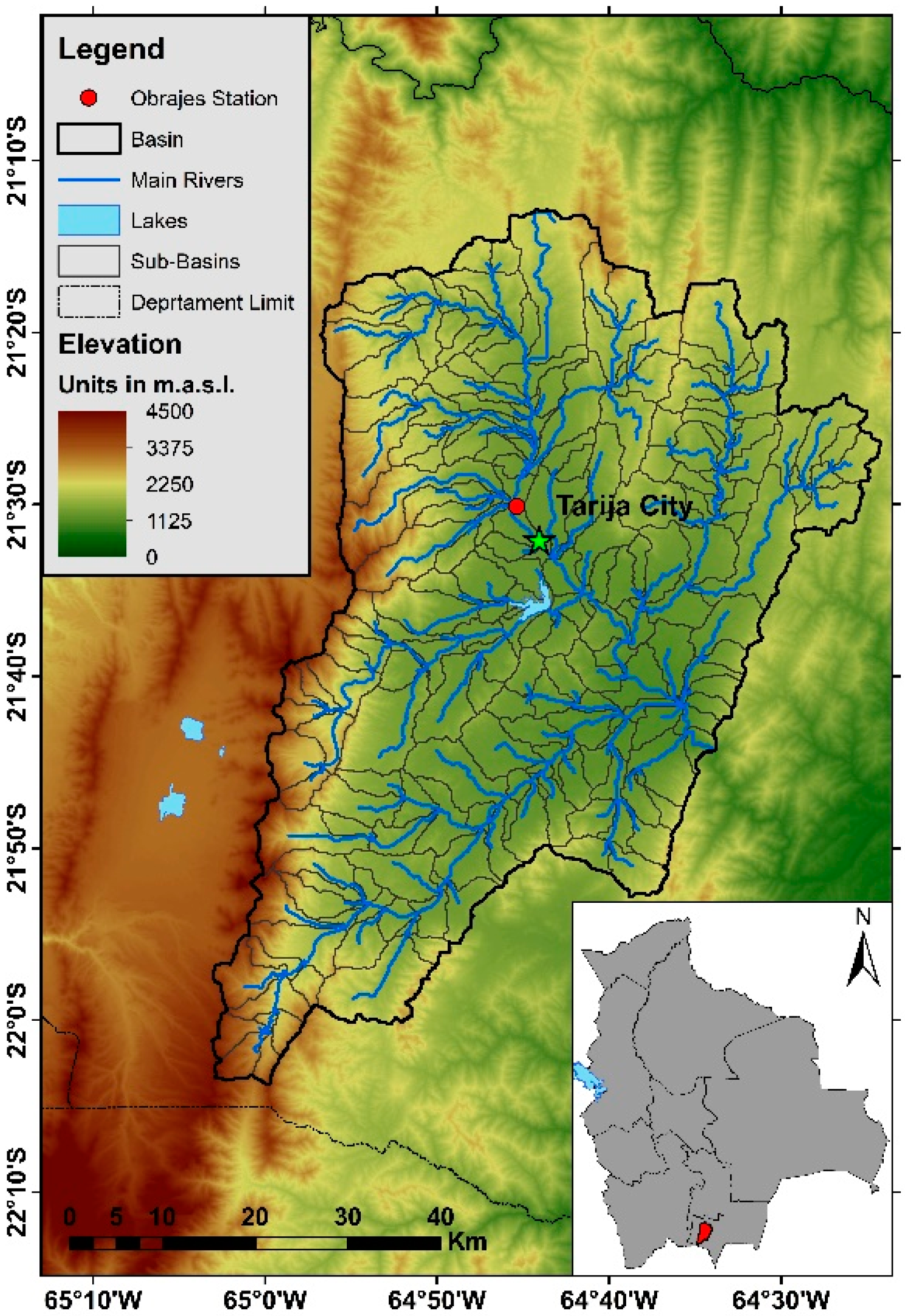
The Guadalquivir River basin is located in the department of Tarija, in southern Bolivia. The basin has an area of 3342 km2, equivalent to 9% of the area of the whole department. The basin has a population of 294,000, encompassing the 51% departmental population. The Guadalquivir basin has elevations between 1600 and 4600 m above sea level [10], presenting two of the national ecological steps, highlands and valleys, with the latter predominating, as can be seen in Figure 1. The basin was divided into 230 micro-basins obtained from the HydroBID database.
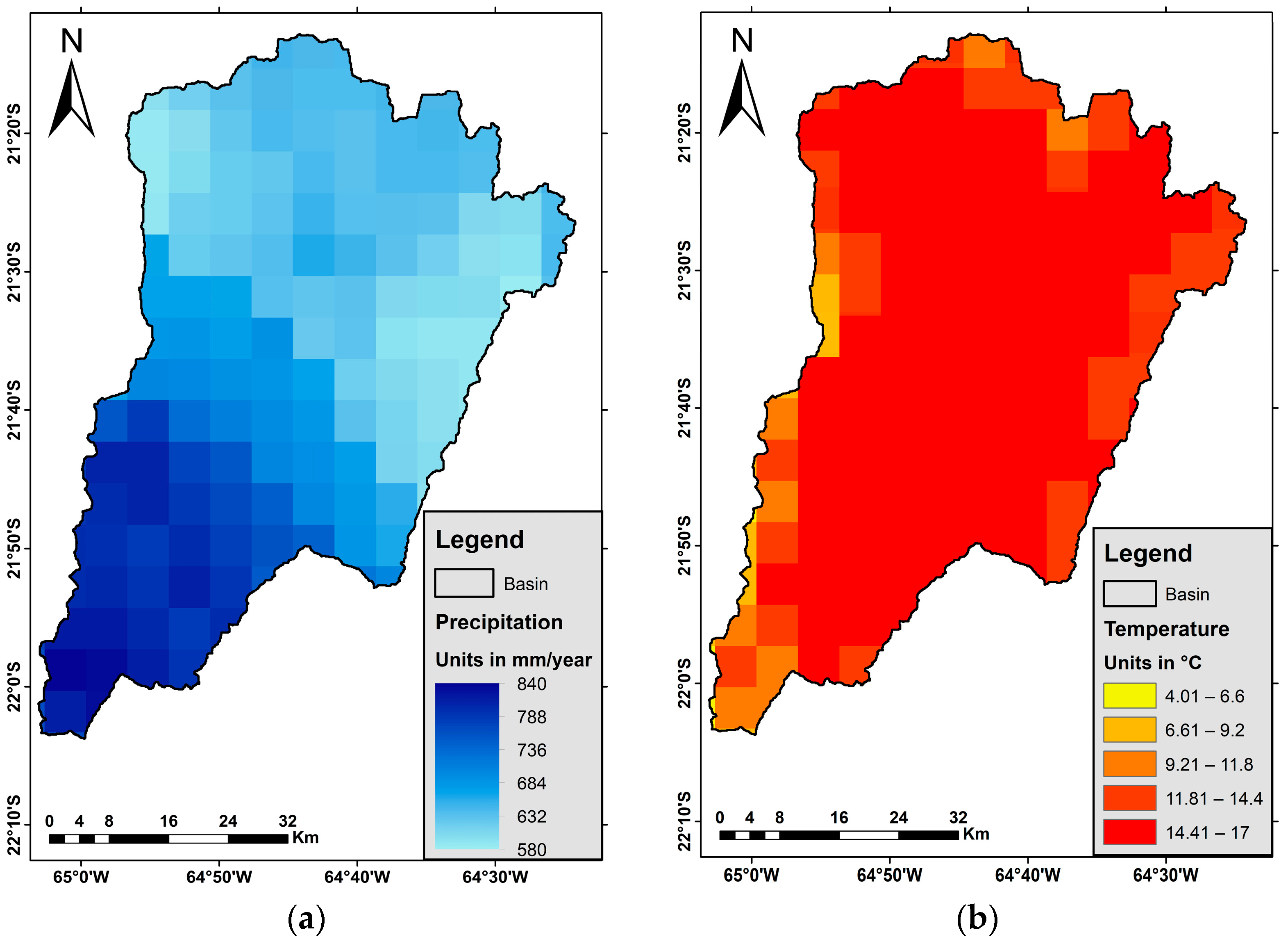
In terms of climatic conditions, the basin shows precipitation between 580 and 840 mm/year, with the highest values occurring at the south of the basin. The average temperatures are between 9 °C and 19 °C, with the highest values in the central part of the basin. These data came from the BHSB database [7]. In Figure 2, the precipitation and temperature distribution maps for the study area can be seen.
Challenges to the basin include water supply, climate change, and pollution. Tarija city, the capital of the department, is located within the basin. Twenty-five percent of the population within the basin experience water-shortage problems. Shortages can equate to 70% of water need. Pollution is the result of the urban and industrial activities of different communities and the city located in the watershed [10]. Finally, heavy metal has been found to be present in a few streams. Lead, iron, and manganese are consequences of mineralogical activity, which has also led to desertification in some zones of the basin [31]. However, studies have been conducted to evaluate treatment methods for the heavy metals, for example, the implementation of reverse osmosis [32].

2.2. Methodology

2.2.1. HydroBID Model

HydroBID model employs the GWLF runoff model. This model uses a micro-basin system and considers land use and soil type for an individual unit analysis. With the HydroBID model, the flow is generated for each micro-basin in the analysis.
This model already has a database prepared for different hydrological variables such as land use, soil types and curve number. Another database included in HydroBID is the Analytical Hydrological Database (AHD), which includes delineated micro-basins and a hydrological network for Latin America and the Caribbean.
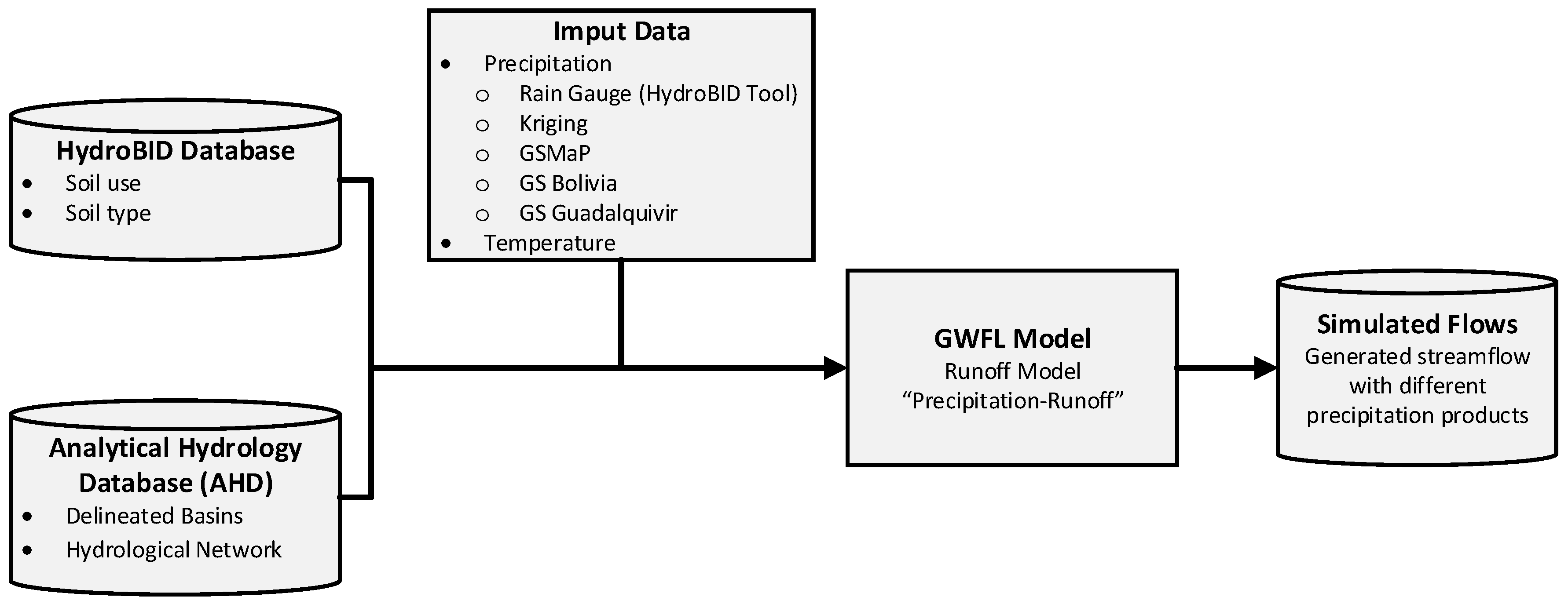
Because of this, the model mainly requires the introduction of climatological variables and observed flow data to perform the calibration and validation of the parameters [21]. Figure 3 shows the methodology used by HydroBID in order to generate flows using the precipitation products.
The flow simulation can be slightly adjusted by the management of four parameters. The Curve Number (CN) allows characterizing the type of land use and representing the hydrology in the soil. A CN value is assigned at each micro-basin. This parameter within the HydroBID can be changed by including a multiplier. The default multiplier value of this parameter is 0.8. The Available Water Content (AWC) indicates the beginning of the percolation process and estimates the amount of water that can be stored in the soil to be used by plants, affecting the infiltration directed to groundwater. Like the previous parameter, the modification of this parameter can be performed using a multiplier. The default value is 1. The Recession Coefficient “r” characterizes the contribution of groundwater near the surface to river flows after a flood event and controls the rate of groundwater flow in the saturated zone. This parameter needs to be entered numerically. The default value is 0.008. Finally, the Percolation Coefficient “s” controls the rate of percolation into the deep groundwater aquifer. The default value is 0.005.
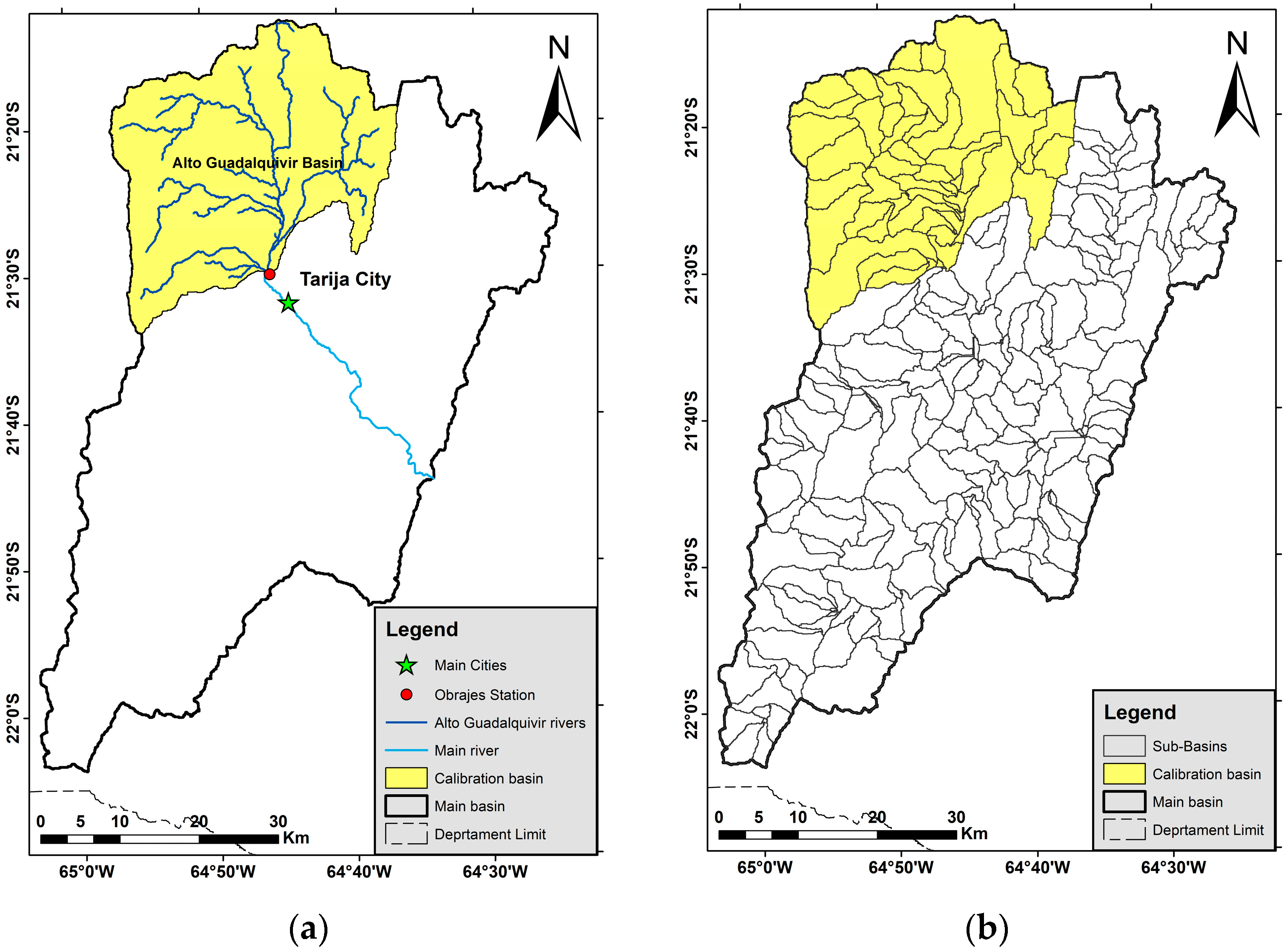
The generated streamflow was evaluated at Obrajes station located at the outlet of the Alta del Guadalquivir basin, see red spot in Figure 4a. Then, the adjusted parameters were used as representative for the whole basin.
In this study, the calibration period was set as between 1/1/1980 and 12/31/1999 and a validation period was set as between 1/1/2000 and 12/31/2014. Figure 4 shows the area of contribution to the Alto Guadalquivir basin with reference to the whole basin, and in Figure 4b the micro-basins are depicted.
The calibration process was carried out with trial and error. Actually, the sensitivity of parameters was analyzed. In this sense, the maximum and minimum values of the different parameters were used (see the left columns in Table 1). Initially, only one parameter was changed at a time, while keeping the default value for the rest. Moreover, statistical indicators, such as Nash and Sutcliffe efficiency and variance in relation to observed data, were included to analyze the simulated streamflow. Then, another parameter’s value was tried. The parameter that displays the greatest sensitivity in efficiency is the curve number, affecting the peak flows, which define infiltration rates. The parameter that generates the highest statistical variability compared to the observed data is the Available Water Content, impacting the base flow and exhibiting errors ranging from −55.9% to 43.3%.
Within the sensitivity analysis, various combinations were tested to obtain simulated flows against the observed ones. As a result of the calibration process, the selected parameter values are compared to the default values (see Table 2).
Based on these parameters, the hydrological modeling of the basin was carried out, obtaining the following hydrographs for calibration (Figure 5a) and validation (Figure 5b) for the periods 1980–1999 and 2000–2014, respectively.
With these simulation values, we proceeded to obtain statistical indicators to determine the proximity between the simulated and observed values. These values are presented in Table 3. Correlation coefficients of 0.709 and 0.744 were obtained for the calibration and validation stages, respectively. The efficiency values were found to be between 0.474 and 0.481, indicating an acceptable approximation in relation to individual observed flows in the station.

2.2.2. Precipitation Data

In the Guadalquivir basin, there are a total of 77 rain gauges. However, the database of these rain gauges presents discontinuous records for 55 stations, meaning that only 22 stations showed complete records. Due to this limitation, the satellite-based precipitation products were used as an alternative in this study.
The management of climatological data is one of the most important aspects of HydroBID. The model allows for the introduction of climatological data in a timely manner through an interpolation method. Specifically, the IDW method is used to obtain a representative value for each sub-basin of the database. To achieve this, a variable allows for the consideration of the number of stations to carry out the IDW interpolation. In the case of the Guadalquivir basin, three stations were used for each micro-basin. The precipitation and temperature values employed in this interpolation process correspond to the values used in the available rain gauge network from BSHB 2018 [7].
However, in the event of a lack of rain gauges, satellite-based products can be used to keep the precipitation pattern. Since these products have different spatial resolutions, a treatment prior to its inclusion in the HydroBID model is needed.
First, the IDW interpolation method, used by HydroBID as the default approach for generating climatological data for micro-basins, was compared with the Kriging method, which was employed in other studies for precipitation data analysis [33]. This product has a daily temporal resolution and a spatial resolution of 0.0025° (approx. 250 m).
The satellite product GSMaP.v6_Gauge was selected as the distributed precipitation product to be used. This product was developed by the Japan Aerospace Exploration Agency (JAXA). The product employs micro-wave and infrared sensors to capture information. This product presents a database from March of 2000 to the current date. GSMaP presents different temporal resolutions: hourly, daily, and monthly. In the case of spatial resolution, the product presents a grid of 0.1° (approx. 10 km). For the case of this study, the product with an hourly temporal resolution was selected, and then it was aggregated daily based on the time difference between Bolivia and the initial data capture zone.
Additionally, the combined precipitation product GS Bolivia was selected to be included in the study. According to Saavedra and Ureña (2022), GS was generated using an iterative methodology that applied the relative error to combined rain gauge and GSMaP data. The product has a daily temporal resolution and spatial temporal resolution of 0.05° (approx. 5 km).
When comparing the GSMaP and GS Bolivia products in the La Plata basin, correlations of 0.33 and 0.98 were observed, respectively. This indicates a significant improvement compared to the original satellite product [30].
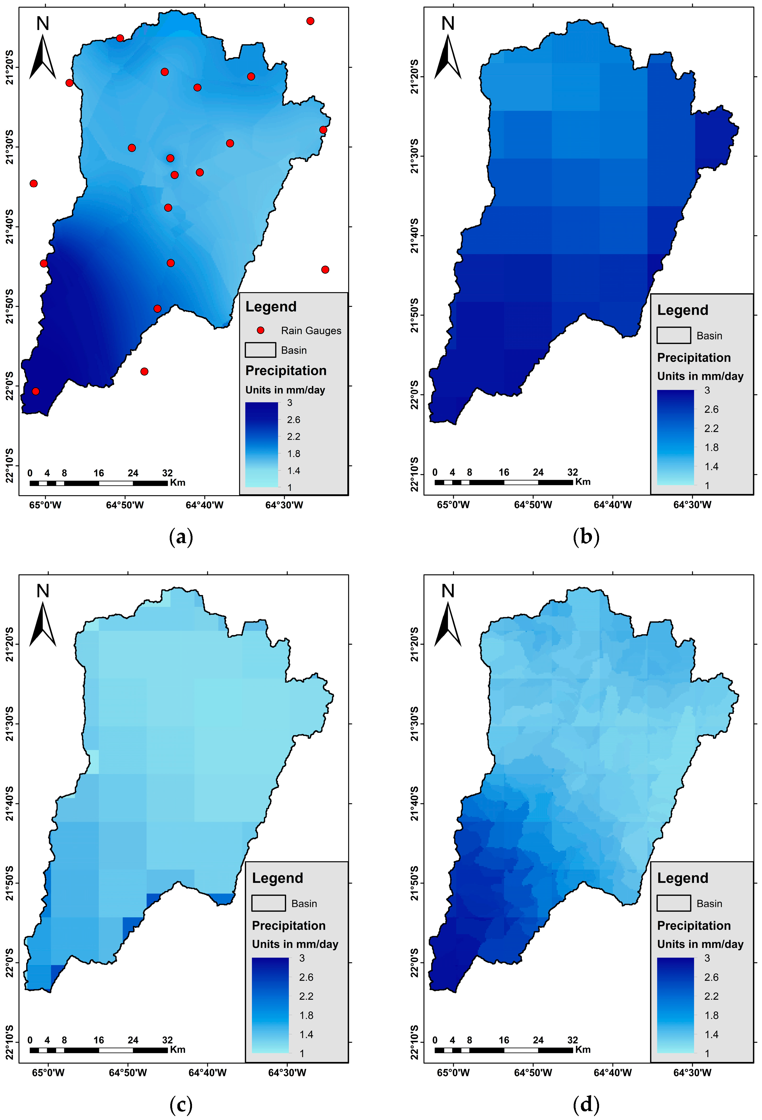
However, the spatial resolution of GS Bolivia is 5 km, causing a loss of precision based on the information at the Guadalquivir basin. To improve this limitation, a new version of the GS product was created, adjusting to the defined 230 micro-basins and a spatial resolution of 250 m. The combination methodology proposed by Saavedra and Ureña (2022) was used, consisting of a combination of daily rain gauge data and a satellite-based precipitation measurement product through an iterative generation methodology. This method uses a correction coefficient based on the relative error at each micro-basin. In the case of the Guadalquivir basin, five iterations were needed to reach convergence. Figure 6 shows the average daily precipitation of the four mentioned products.
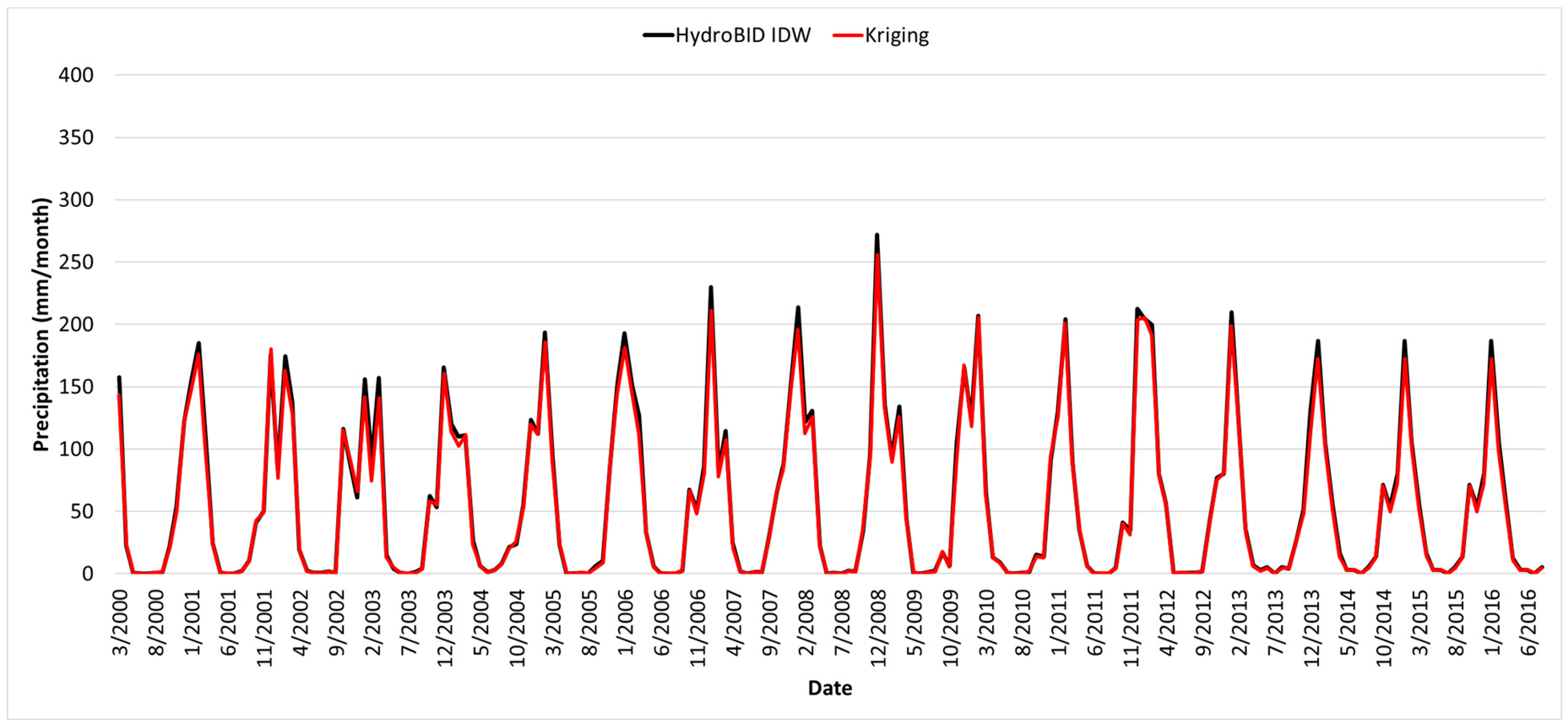
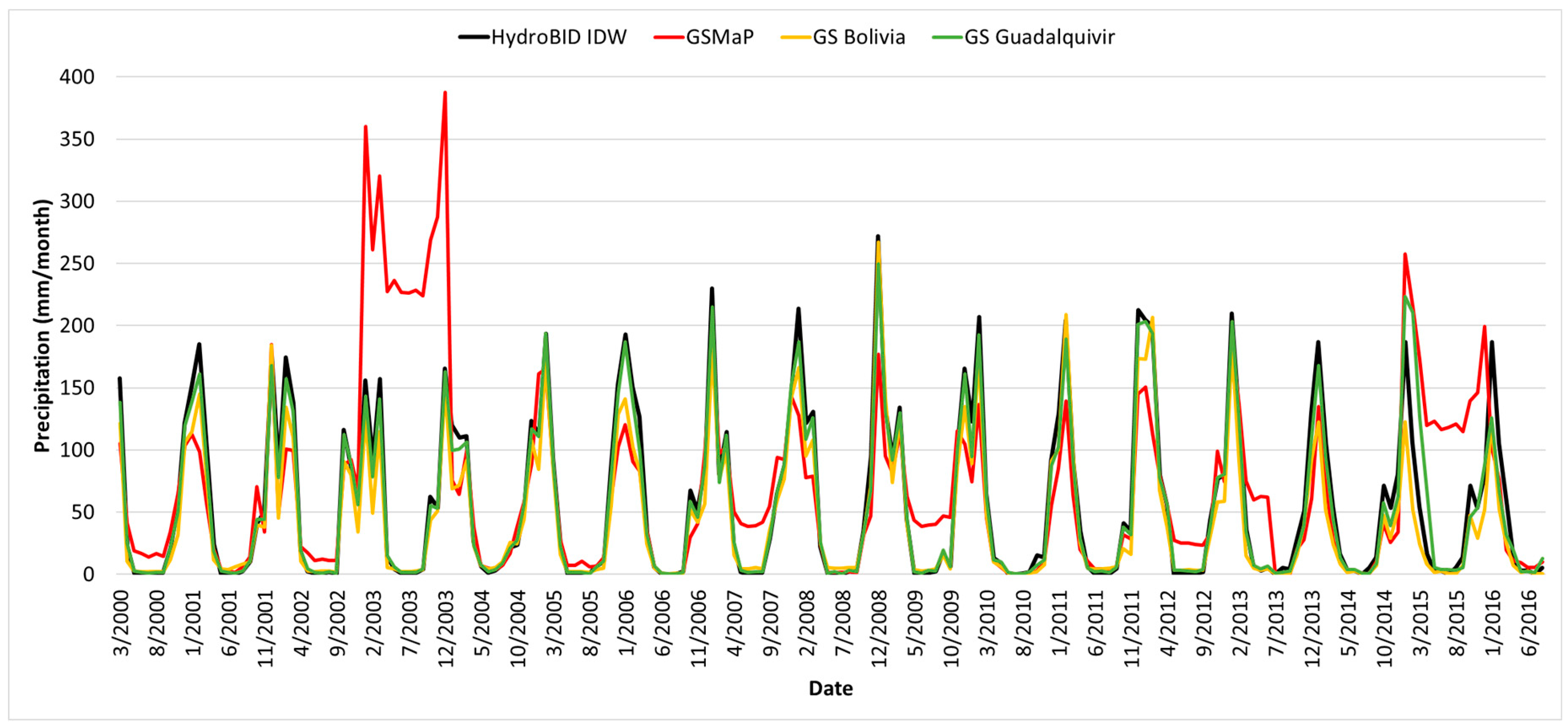
The default rain gauge precipitation data generated by HydroBID presents a great resemblance to the precipitation data generated with Kriging interpolation. In Figure 7, the precipitation data obtained using Kriging shows a slight difference at the high values compared to the precipitation data interpolated by IDW from HydroBID.
In the case of satellite-based precipitation products, GSMaP presents a general underestimation in the period 2000–2014. However, during the periods from 09/2002 to 12/2003 and from 03/2015 to 06/2016, it shows several overestimations. In contrast, the GS Bolivia data displays a general underestimation throughout the study period. As for GS Guadalquivir, the precipitation closely resembles the IDW interpolation by HydroBID. These patterns can be seen in Figure 8.
Moreover, a statistical analysis was carried out for the study area. It was observed that GS Bolivia correlations of 0.54 and 0.78 were obtained in Guadalquivir basin. However, using the GS Guadalquivir product found a correlation of 0.98. The efficiency of the Nash and Sutcliffe product increases slightly depending on the size of the study area. The comparative indicators are summarized in Table 4.

3. Results

3.1. Flow Analysis

For the generation of flows through the HydroBID tool, the distributed precipitation data were used. The method of introducing these was adjusted from distributed maps to representative values per hydrological unit of the model.
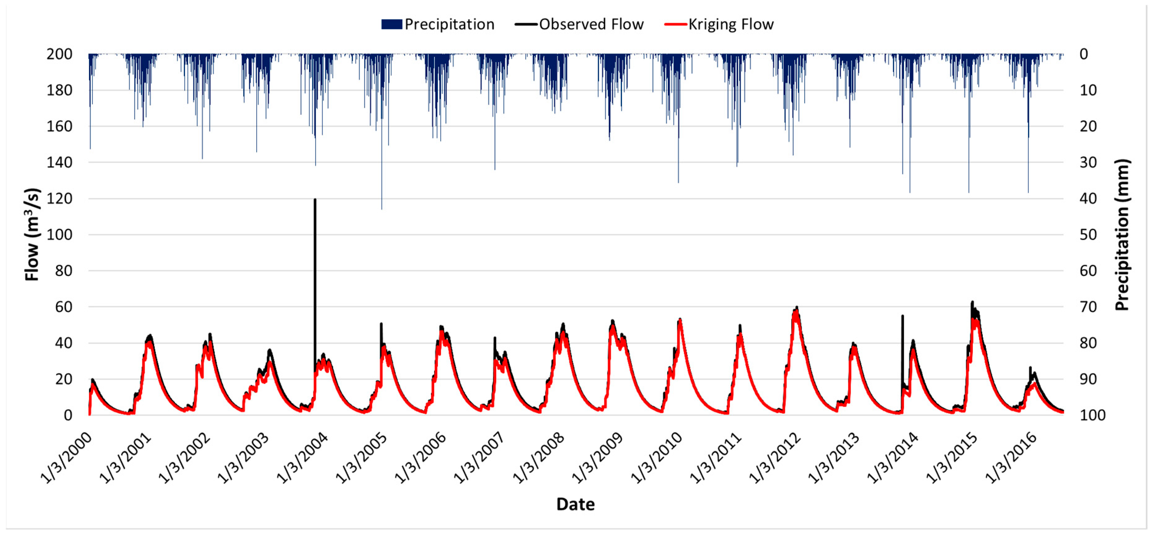
As a result, in Figure 9, the data iterated through the Kriging method show simulated flows very similar to those observed through the IDW method. The Kriging flows present a drastic reduction in the maximum values registered in January 2004 and 2014 within the study period. This is due to the way the Kriging method generates the data, where the maximum and minimum values of the input data are reduced by the logic of the interpolation model.
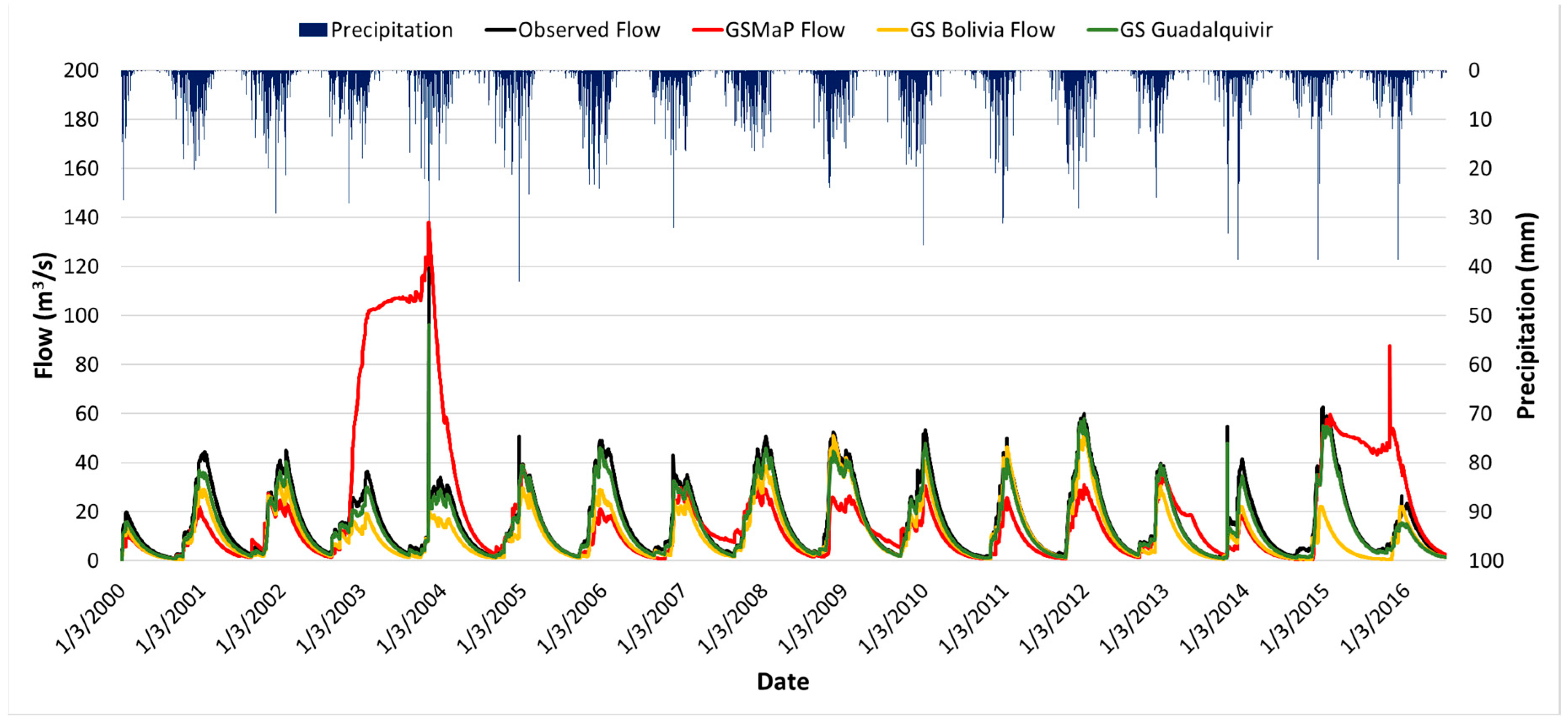
Figure 10 shows a comparison of the simulated flows using the products derived from satellites: GSMaP, GS Bolivia, and GS Guadalquivir. In the case of GSMaP precipitation, the simulated flows presented a general underestimation throughout the assessed period. However, during the periods 2003–2004 and 2015–2016, there are cases of persistent overestimations.
However, the simulated flows using GS products show closer agreement to the overserved flow. Actually, the GS Guadalquivir product exhibits the highest similarity to the observed values, even simulating the peak flows recorded in 2004 and 2014.
Statistically analyzing the flows, the GSMaP product presents the lowest indicators in relation to the other products, as seen in Table 5. With a correlation of 0.28 and a negative efficiency, the flows generated by this satellite product present an overestimation flow. However, the other products present correlations greater than 0.9 and present a positive efficiency, with the Kriging and GS version for Guadalquivir products being the ones with the best indicators.
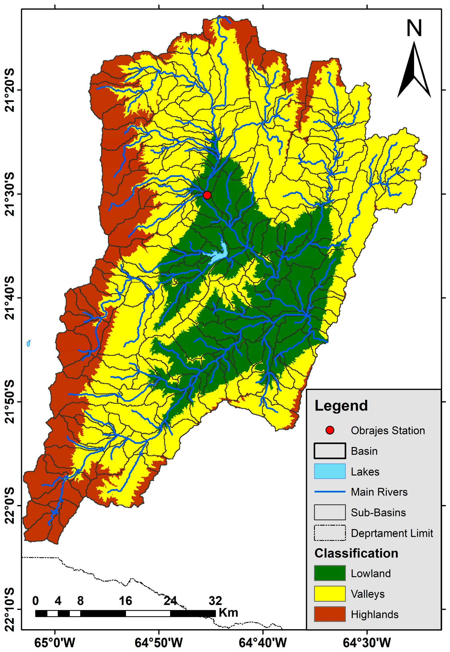
Moreover, the specific river discharge at each micro-basin was estimated in the Guadalquivir basin. This variable makes possible the comparison of the amount of streamflow that can be generated per unit of area. Three main regions within the basin were classified based on elevation: highlands, valleys, and lowlands, as seen in Figure 11.
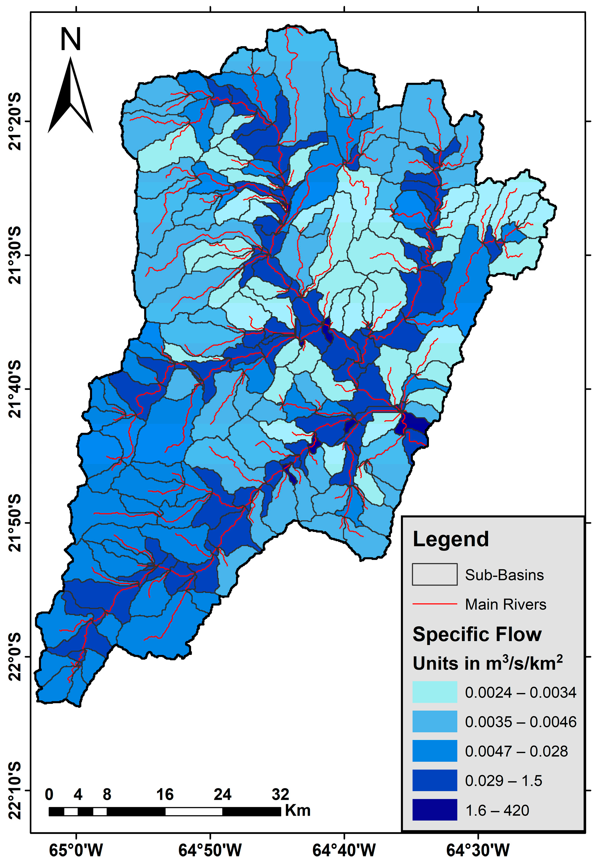
As expected, the specific river discharge at lowlands showed higher values due to the flow accumulation downstream. Using the GS Guadalquivir product, values of 0.039, 0.095, and 4.892 m3/s/km2 were obtained in the highlands, valleys, and lowlands, respectively. The complete values for four products can be seen in Table 6.
Then, a specific river discharge using the GS Guadalquivir product was generated showing the differences among micro-basins, as seen in Figure 12. Four main contributions to the main river in the direction to the outlet can be seen. Particularly, there were higher values in the southwestern part where the Sama Biological protected area is located. This finding is consistent with the higher precipitation pattern in this southwestern zone.

3.2. Volume Analysis

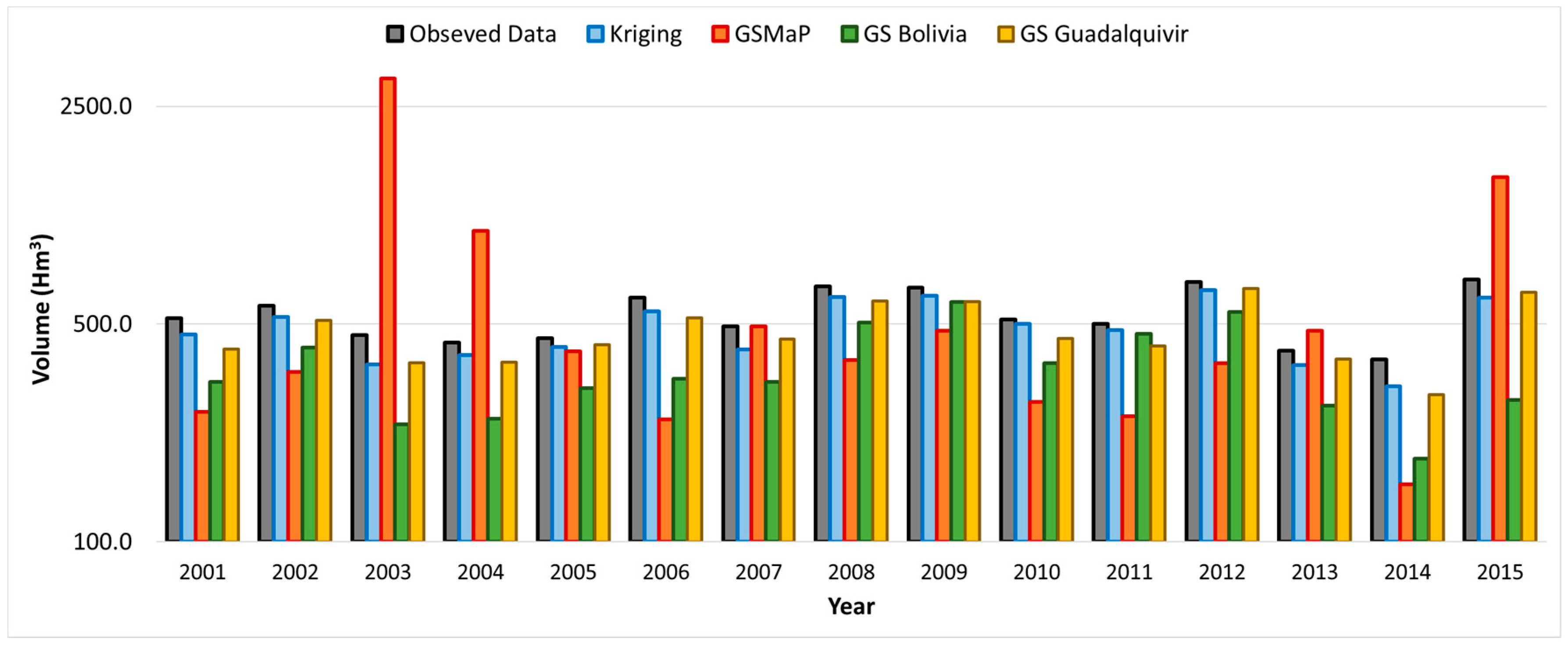
Further analysis is presented of the annual volumes resulting from the flows generated. Figure 13 shows the different volumes obtained from the streamflow modeling of the different products. Using Kriging and GS Guadalquivir, simulated volumes with HydroBID were plotted against observed volumes. However, during the period 2008–2011, GS Guadalquivir presents an underestimation that is not appreciated in Kriging. The GS Bolivia product showed cases of underestimations throughout the modeling period.
Based on these data, statistical indicators were generated that allowed us to analyze the behavior of the volumes and corroborate the observations. According to the data in Table 7, the precipitation generated using Kriging presents a correlation of 0.98, close to the default values generated by HydroBID, and, thanks to the efficiency of Nash and Sutcliffe, a minimum variance can be determined. A similar case can be observed with the GS Guadalquivir product, which presents a correlation of 0.97 and an efficiency of 0.98.
The difference lies in the database, where, through the mean absolute error (MAE) and the root mean square error (RMSE), a slight difference is observed where Kriging presents a better tendency in relation to GS Guadalquivir. However, the GSMaP product presents a correlation of 0.06 and a negative efficiency, indicating its lack of similarity with the observed volumes.

4. Discussion

4.1. Precipitation Data

The meteorological introduction data tool of HydroBID employs by default the IDW interpolation to generate the value per hydrological unit. This study analyzed the possibility of distributed precipitation values. Subsequently, an aerial precipitation was calculated for each hydrological unit. Kriging interpolation rain gauge data, GSMaP_Gauge.v6, and GS Bolivia [30] were tested. Only the Kriging data presented a similar correlation to that generated with the IDW method. The product GS Bolivia showed a correlation in the La Plata basin of 0.98. In the analysis for the Guadalquivir basin, the correlation was reduced to 0.8. For this reason, a new version of this product was developed for the basin, increasing the spatial resolution to 250 m.
The iterative method to generate the combined precipitation product was found very useful to fulfill the required spatial resolution of 230 micro-basins. Five iterations were found to be enough to reach convergence.

4.2. HydroBID as a Hydrological Model

The model employed for the Guadalquivir basin was set up without further inconvenience. The inclusion of a soil type database and its assignment to each of the micro-basins comprising the AHD allows HydroBID users to have support when collecting and formatting other required variables (such as precipitation and temperature). Moreover, the soil type is based on the Global Land Cover Characterization (GLCC) of 1993 [21]. To present more accurate results, it is possible to develop interpretation and management skills to update the HydroBID database at a smaller scale. However, addressing this issue is beyond the scope of their study.
The calibration and validation of the model parameters were carried out smoothly with trial-and-error analysis checking both visual and statistical indicators. Since there are only four parameters to calibrate, the job becomes feasible in terms of computation cost. Actually, CN and AWC use multipliers, which narrows the spectrum of options. The multipliers are applied at each micro-basin.
The Guadalquivir HydroBID model was run with different precipitation products. The raw GSMaP product highlighted the need to analyze satellite-based precipitation data before using it in modeling. Due to the overestimation cases observed, it is plausible that a similar error may occur when using other satellite products.
Another significant aspect in handling satellite products is the spatial resolution. TRMM, with a spatial resolution of 25 km, offers lower precision when using its data. In the present study of the Guadalquivir basin, products with resolutions of 10, 5, and 0.25 km were employed, with Kriging interpolation and the GS Guadalquivir product presenting the smallest resolution and yielding better results.

4.3. Applications of HydroBID Model

Regarding the volume analysis, at recent studies in hydrological models of this basin, values of 436, 514, and 647 Hm3 were reported [8,9,10]. In the present study, the simulated average values were 536, 485, 647, 362 and 474 Hm3 using rain gauges, Kriging interpolation, GSMaP, GS Bolivia and GS Guadalquivir, respectively. In the case of Kriging and GS Guadalquivir precipitations products, the variance in relation to previous reported data is between 9 and 11%, with a tendency to underestimate values. Then, the estimates using GS Guadalquivir are recommended to be employed.
These volumes in future studies can be used to encourage sustainable development considering water consumption per capita, hectares to be irrigated, storage volumes required for hydroelectric power generation and environmental flow.
Finally, since Guadalquivir basin is located in a semi-arid region, and the specific river discharge was already estimated, a sediment transport analysis is feasible to be performed using the module within HydroBID platform.

5. Conclusions

In this study, a hydrological model of the Guadalquivir basin has been set up using the HydroBID tool and combined precipitation products. The results showed considerable adaptability when used with these products. During the calibration of the model parameters, the Curve Number (CN) showed control over the simulation of peak flows. However, the Available Water Content (AWC) generally controls the baseflow. The calibration and validation of the model depicted correlation coefficients of 0.709 and 0.744, respectively.
After the generation of the GS precipitation product version for Guadalquivir (GS Guadalquivir), this product obtained a correlation of 0.98 and an efficiency of 0.97. These results are much better than those obtained with GS Bolivia, which presented a correlation of 0.78 and an efficiency 0.82. The transition from a spatial resolution of 5 km to 250 m showed an improvement in the precipitation data.
In the modeling process with the generated precipitation data, it was observed that the data management with Kriging and the GS Guadalquivir product presented high correlations in relation to the simulated flows with HydroBID (0.99 for both products). However, the GS product presents a better visual approach to the modeled flows, even simulating extreme flows with slight underestimations. In the case of GSMaP and GS Bolivia, these products present general underestimations of the flows simulated by the model, reaching correlations between 0.28 and 0.91, respectively.
In the case of GSMaP, it is possible to observe overestimated flows in the periods 2003–2004 and 2015–2016 that could not be detected with the precipitation analysis. In the case of GS Bolivia, this product presented an MAE of 5.47 and an RMSE of 8.21, double and quadruple the values of its exclusive version of the basin.
Analyzing the annual volumes in the basin, we observed firstly the overestimation of values presented by GSMaP, which reached 4 times the maximum value registered by the original simulated products. Kriging and GS Guadalquivir presented similar characteristics with respect to the distribution of volumes, emphasizing a greater number of underestimations by the GS product. This is validated with the MAE and RMSE values presented by these products (50.7 and 62.7 for MAE and 62.7 and 67.1 in the case of RMSE).
Furthermore, when analyzing the output volumes at the end of the basin, it can be observed that the products using IDW and Kriging precipitation show a slight difference, strengthening the usage of interpolated rain gauges with the HydroBID model. In the case of GS Guadalquivir, the volume presents a similar behavior to Kriging, and this product presents better values than GSMaP.
In summary, three main achievements are reported in this study: (1) the generation of a GS Guadalquivir satellite-based precipitation product with 230 micro-basins; (2) the usage of the HydroBID tool to convert precipitation products into simulated flows, specific river discharge, and volumes within micro-basins; (3) the ground validation of satellite-based precipitation products at two stages, against local rain gauges and the observed streamflow.
The use of HydroBID In other basins is therefore recommended as a support tool not only for flow forecasts but also for water resources management.
Author Contributions

Conceptualization, J.U. and O.S.; methodology, O.S. and J.U.; software, J.U.; validation, J.U., O.S. and M.P.; formal analysis, O.S.; investigation, J.U.; resources, J.U., O.S. and M.P.; data curation, J.U. and M.P.; writing—original draft preparation, O.S. and J.U.; writing—review and editing, O.S. and M.P.; visualization, O.S.; supervision, O.S. and M.P.; project administration, O.S. All authors have read and agreed to the published version of the manuscript.

Funding

This research received no external funding.

Data Availability Statement

Publicly available data sets were analyzed in this study. The combined precipitation product GS data can be found here: https://drive.google.com/drive/folders/1tkXsnLO3HO4joEIb7DE6NuLMDOYc1V7Y?usp=sharing.

Acknowledgments

This research has been supported by the 3rd Research Announcement on the Earth Observations of the Japan Aerospace Exploration Agency (JAXA) for data sharing of GSMaP_Gauge v6. Moreover, we would like to thank engineer Mario Gamarra, researcher at Universidad Autónoma Juan Misael Saracho, for his insightful comments to this study.

Conflicts of Interest

The authors declare no conflict of interest.

References

  1. Chen, H.; Huang, S.; Xu, Y.-P.; Teegavarapu, R.S.V.; Guo, Y.; Xie, J.; Nie, H. Quantitative Assessment of Impact of Climate Change and Human Activities on Streamflow Changes Using an Improved Three-Parameter Monthly Water Balance Model. Remote Sens. 2022, 14, 4411. [Google Scholar] [CrossRef]
  2. Darbandsari, P.; Coulibaly, P. Inter-Comparison of Lumped Hydrological Models in Data-Scarce Watersheds Using Different Precipitation Forcing Data Sets: Case Study of Northern Ontario, Canada. J. Hydrol. Reg. Stud. 2020, 31, 100730. [Google Scholar] [CrossRef]
  3. Paul, P.K.; Zhang, Y.; Mishra, A.; Panigrahy, N.; Singh, R. Comparative Study of Two State-of-the-Art Semi-Distributed Hydrological Models. Water 2019, 11, 871. [Google Scholar] [CrossRef]
  4. Jiang, S.; Ding, Y.; Liu, R.; Wei, L.; Liu, Y.; Ren, M.; Ren, L. Assessing the Potential of IMERG and TMPA Satellite Precipitation Products for Flood Simulations and Frequency Analyses over a Typical Humid Basin in South China. Remote Sens. 2022, 14, 4406. [Google Scholar] [CrossRef]
  5. Pamirbek kyzy, M.; Chen, X.; Liu, T.; Duulatov, E.; Gafurov, A.; Omorova, E.; Gafurov, A. Hydrological Forecasting under Climate Variability Using Modeling and Earth Observations in the Naryn River Basin, Kyrgyzstan. Water 2022, 14, 2733. [Google Scholar] [CrossRef]
  6. Ministerio de Medio Ambiente y Agua. Balance Hídrico Superficial de Bolivia: Documento de Difusión; Ministerio de Medio Ambiente y Agua: La Paz, Bolivia, 2016; ISBN 978-99954-774-8-6.
  7. Ministerio de Medio Ambiente y Agua. Balance Hídrico Superficial de Bolivia (1980–2016): Documento de Difusión; Ministerio de Medio Ambiente y Agua: La Paz, Bolivia, 2018.
  8. Espejo, A. Balance Hídrico Integral Para La Cuenca Del Río Guadalquivir; Ministerio de Medio Ambiente y Agua: Tarija, Bolivia, 2016.
  9. Caba, J. Mapeo Temático de La Oferta, Uso Actual y Disponibilidad Delos Recursos Hídricos Del Valle Central de Tarija, En El Marco Del Sistema de Información Hídrica Del Valle Central de Traija-SIHITA; Gobierno Autónomo Departamental de Tarija: Tarija, Bolivia, 2018. [Google Scholar]
  10. Plataforma Interinstitucional de la Cuenca Guadalquivir. Plan Director de La Cuenca Del Río Guadalquivir Programa Plurianual 2021–2025; Ministerio de Medio Ambiente y Agua: Tarija, Bolivia, 2022.
  11. Sieber, J.; Purkey, D. WEAP Water Evaluation and Planning System—User Guide; Stockholm Environmental Institute, U.S. Center: Somerville, MA, USA, 2015. [Google Scholar]
  12. Lima-Quispe, N.; Coleoni, C.; Rincón, W.; Gutierrez, Z.; Zubieta, F.; Nuñez, S.; Iriarte, J.; Saldías, C.; Purkey, D.; Escobar, M.; et al. Delving into the Divisive Waters of River Basin Planning in Bolivia: A Case Study in the Cochabamba Valley. Water 2021, 13, 190. [Google Scholar] [CrossRef]
  13. Zarate, S.; Villazon, M.; Navia, M.; Balderrama Subieta, S.L.; Quoilin, S. Modeling Hydropower to Assess Its Contribution to Flexibility Services in the Bolivian Power System; SWEDES: Dubrovnik, Croatia, 2021. [Google Scholar]
  14. Fernandez, J.; Wickel, B.A.; Escobar, M. Hydro-Ecological Monitoring of High-Elevation Wetlands in the Katari Watershed, Bolivia; Stockholm Environment Institute: Stockholm, Sweden, 2021. [Google Scholar]
  15. Mautner, M.R.L.; Coleoni, C.; Forni, L. Socioeconomic Modeling for Water Resource Planning: Optimizing Crop Distribution in the Bolivian Andes under Hydrologic and Social Constraints. In Proceedings of the American Geophysical Union Fall Meeting, Chicago, IL, USA, 12–16 December 2022. [Google Scholar] [CrossRef]
  16. Sahu, M.K.; Shwetha, H.R.; Dwarakish, G.S. State-of-the-Art Hydrological Models and Application of the HEC-HMS Model: A Review. Model. Earth Syst. Environ. 2023, 9, 3029–3051. [Google Scholar] [CrossRef]
  17. Li, J.; Zhao, Y.; Bates, P.; Neal, J.; Tooth, S.; Hawker, L.; Maffei, C. Digital Elevation Models for Topographic Characterisation and Flood Flow Modelling along Low-Gradient, Terminal Dryland Rivers: A Comparison of Spaceborne Datasets for the Río Colorado, Bolivia. J. Hydrol. 2020, 591, 125617. [Google Scholar] [CrossRef]
  18. García, W.; Delfín, M.; Ledezma, M.; Arévalo, B. Integrando Métodos de Evaluación de Riesgos de Deslizamientos e Inundaciones En Cuencas Del Tunari y Zona de Alto Cochabamba. Acta Nova 2021, 10, 61–95. [Google Scholar]
  19. Achá, N.A.; Saavedra, O.C.; Ureña, J.E. Modelación Hidrológica en la Cuenca del Río Rocha Incorporando Lineamientos de Caudal Ecológico. Rev. Investig. Desarro. 2022, 22, 49–62. [Google Scholar] [CrossRef]
  20. Villazon, M.; Maldonado Zegarra, I. Hourly Continuous Hydrologic Modelling of the Rocha River Basin; XIX Congreso Internacional Región II de Ingeniería Sanitaria y Ambiental AIGIS: La Paz, Bolivia, 2022. [Google Scholar]
  21. Moreda, F.; Miralles-Wilhelm, F.; Muñoz, R. Hydro-BID: An Integrated System for Modeling Impacts of Climate Change on Water Resources. Part 2; Inter-American Development Bank: New York, NY, USA, 2014. [Google Scholar]
  22. Miralles-Wilhelm, F.; Brantly, E. Water Resources Management and Climate Adaptation in the Río Grande Basin, Argentina: A Case Study Introducing the Hydro-BID Modelling System. In Water and Cities in Latin America: Challenges for Sustainable Development; Earthscan Studies in Water Resource Management; Routledge, Taylor & Francis Group: London, UK; New York, NY, USA, 2015; ISBN 978-0-415-73097-6. [Google Scholar]
  23. Wyatt, A.; Moreda, F.; Brantly, E.; Miralles-Wilhelm, F.; Muñoz Castillo, R. Caso de Estudio de Hydro-BID No 1: Modelo de Gestión Del Recurso Hídrico En La Cuenca Del Río Grande En Argentina; Inter-American Development Bank: New York, NY, USA, 2014. [Google Scholar]
  24. Moreda, F.; Miralles-Wilhelm, F.; Muñoz Castillo, R.; Coli Valdes Daussa, P. Hydro-BID Case Study No 2: Modeling the Impact of Climate Change on Flows of the Rio Piura Using Hydro-BID; Inter-American Development Bank: New York, NY, USA, 2014. [Google Scholar]
  25. Escurra, J.; Moreda, F.; Brantly, E.; Coli Valdes Daussa, P. Hydro-BID Case Study No. 3: Impact of El Niño Events on Sediment Loading in the Chancay-Lambayeque Basin, Peru; Inter-American Development Bank: New York, NY, USA, 2016. [Google Scholar]
  26. Moreda, F.; Lord, B.; Coli Valdes Daussa, P.; Corrales, J.C. Hydro-BID Case Study No. 4: Application of Hydro-BID in Bermejo River Basin to Quantify Sediment Loads, Argentina; Inter-American Development Bank: New York, NY, USA, 2016. [Google Scholar]
  27. Moreda, F.; Coli Valdes Daussa, P.; Brantly, E.; Serago, J.; Escurra, J. Hydro-BID Case Study No. 5: Impact of Climate Change on Proposed Water Investments in Chalpi Basin, Ecuador; Inter-American Development Bank: New York, NY, USA, 2017. [Google Scholar]
  28. Mena, D.; Solera, A.; Restrepo, L.; Pimiento, M.; Cañón, M.; Duarte, F. An Analysis of Unmet Water Demand under Climate Change Scenarios in the Gualí River Basin, Colombia, through the Implementation of Hydro-BID and WEAP Hydrological Modeling Tools. J. Water Clim. Chang. 2021, 12, 185–200. [Google Scholar] [CrossRef]
  29. Ureña, J.; Saavedra, O.; Kubota, T. The Development of a Combined Satellite-Based Precipitation Dataset across Bolivia from 2000 to 2015. Remote Sens. 2021, 13, 2931. [Google Scholar] [CrossRef]
  30. Saavedra, O.; Ureña, J. Generation of Combined Daily Satellite-Based Precipitation Products over Bolivia. Remote Sens. 2022, 14, 4195. [Google Scholar] [CrossRef]
  31. Alvizuri-Tintaya, P.A.; Villena-Martínez, E.M.; Avendaño-Acosta, N.; Lo-Iacono-Ferreira, V.G.; Torregrosa-López, J.I.; Lora-García, J. Contamination of Water Supply Sources by Heavy Metals: The Price of Development in Bolivia, a Latin American Reality. Water 2022, 14, 3470. [Google Scholar] [CrossRef]
  32. Villena-Martínez, E.M.; Alvizuri-Tintaya, P.A.; Lora-García, J.; Torregrosa-López, J.I.; Lo-Iacono-Ferreira, V.G. Reverse Osmosis Modeling Study of Lead and Arsenic Removal from Drinking Water in Tarija and La Paz, Bolivia. Processes 2022, 10, 1889. [Google Scholar] [CrossRef]
  33. Ureña, J.; Saavedra, O. Evaluation of Satellite Based Precipitation Products at Key Basins in Bolivia. Asia-Pac. J. Atmos. Sci. 2020, 56, 641–655. [Google Scholar] [CrossRef]
Figure 1. Location map of Tarija city within Guadalquivir River basin, in southern Bolivia.
Water 15 03250 g001
Figure 2. Average annual meteorological maps for the period 2001–2016 in Guadalquivir basin for (a) precipitation and (b) temperature, with rain gauge data interpolation.
Water 15 03250 g002
Figure 3. HydroBID flowchart for hydrological modelling using different precipitation inputs.
Water 15 03250 g003
Figure 4. (a) Alto Guadalquivir basin, Obrajes station and Tarija city; (b) Micro-basins with average of 15 km2 in Guadalquivir River basin.
Water 15 03250 g004
Figure 5. Hydrographs for (a) calibration and (b) validation in the Obrajes station.
Water 15 03250 g005
Figure 6. Guadalquivir precipitation daily map for the period 2001–2015: (a) Kriging interpolation, (b) GSMaP.v6_Gauge, (c) GS Bolivia, and (d) GS Guadalquivir.
Water 15 03250 g006
Figure 7. Time series of monthly precipitation from interpolated rain gauge products for the period 2000–2016.
Water 15 03250 g007
Figure 8. Time series of monthly precipitation for rain satellite-based products for the period 2000–2016.
Water 15 03250 g008
Figure 9. Simulated and observed hydrographs using interpolated rain gauge with Kriging method.
Water 15 03250 g009
Figure 10. Simulated and observed hydrographs using satellite and combined precipitation.
Water 15 03250 g010
Figure 11. Three main regions within Guadalquivir basin.
Water 15 03250 g011
Figure 12. Distribution of specific river discharge using GS Guadalquivir product.
Water 15 03250 g012
Figure 13. Annual simulated volume using four simulated flows against observed streamflow.
Water 15 03250 g013
Table 1. HydroBID’s parameter ranges for the contributing area down to Obrajes station.
ParameterValuesNash and Sutcliffe EfficiencyVariance (%)
MinMaxMinMaxMinMax
Curve Number (CN)0.110.1−3.5−23.812.6
Available Water Content (AWC)0.12−0.5−0.843.3−55.9
Recession Coefficient0.00010.01−1.3−0.5−13.3−14.9
Percolation Coefficient0.00010.01−0.7−0.522.1−40.7
Table 2. Default and calibrated parameters for Obrajes basin.
ParametersDefaultCalibrated
Curve Number (CN)0.80.46
Available Water Content (AWC)10.1
Recession Coefficient0.0080.006
Percolation Coefficient0.0050.008
Table 3. Statistic indicators for calibration and validation process in Alto Guadalquivir basin.
Statistic IndicatorsCalibrationValidation
Determination Coefficient (R2)0.5030.554
Correlation Coefficient (R)0.7090.744
Mean Absolute Error (MAE)1.8461.447
Root Mean Square Error (RMSE)3.2302.428
Nash and Sutcliffe Efficiency (NSE)0.4740.481
Variation (%)−14.2113.5
Table 4. Statistic indicators for satellite and combined precipitation.
Statistic IndicatorsGSMaPGS BoliviaGS Guadalquivir
Determination Coefficient (R2)0.300.620.95
Correlation Coefficient (R)0.540.780.98
Mean Absolute Error (MAE)1.820.740.17
Root Mean Square Error (RMSE)3.341.630.70
Nash and Sutcliffe Efficiency (NSE)0.250.820.97
Table 5. Statistic indicators of simulated streamflow using satellite and combined products.
Statistic IndicatorsKrigingGSMaPGS BoliviaGS Guadalquivir
Determination Coefficient (R2)0.980.080.830.99
Correlation Coefficient (R)0.990.280.910.99
Mean Absolute Error (MAE)1.6413.585.472.02
Root Mean Square Error (RMSE)2.6425.828.212.82
Nash and Sutcliffe Efficiency (NSE)0.96−2.470.650.96
Table 6. Specific river discharge in Guadalquivir basin.
Streamflow (m3/s/km2)HighlandsValleysLowlands
Rain Gauge (HydroBID)0.0440.1075.689
Kriging Interpolation0.0290.0945.176
GSMaP0.0380.1286.962
GS Bolivia0.0230.0733.917
GS Guadalquivir0.0390.0954.892
Table 7. Statistic indicators for satellite and combined volume.
Statistic IndicatorsKrigingGSMaPGS BoliviaGS Guadalquivir
Determination Coefficient (R2)0.950.000.500.95
Correlation Coefficient (R)0.980.060.700.97
Mean Absolute Error (MAE)50.742617462.7
Root Mean Square Error (RMSE)55.074819467.1
Nash and Sutcliffe Efficiency (NSE)0.99−1.000.870.98
Disclaimer/Publisher’s Note: The statements, opinions and data contained in all publications are solely those of the individual author(s) and contributor(s) and not of MDPI and/or the editor(s). MDPI and/or the editor(s) disclaim responsibility for any injury to people or property resulting from any ideas, methods, instructions or products referred to in the content.