1. Introduction
Water inrush incidents pose a formidable peril, imperiling both the safety of miners and the efficiency of coal production [
1]. The specter of water inrush accidents looms large over the mining safety landscape worldwide, particularly in nations with robust coal industries, such as China, the United States, India, Iran and Australia [
2,
3,
4]. Despite stringent regulatory measures, these catastrophes have tragically exacted a heavy toll in terms of lives lost and properties devastated over the years [
5]. In light of their capricious nature, the ability to accurately and promptly distinguish water sources assumes paramount importance for mitigating water inrush incidents [
6].
While the intellectual luminaries in this domain have undoubtedly made noteworthy strides, the rapid surge of information technology and the multidisciplinary paradigm necessitate a systematic audit and synthesis of the methodologies for discerning water origins within mine water inrush scenarios. The aim of this discourse is to address this exigency by comprehensively scrutinizing scholarly accomplishments related to water source discrimination in the context of mine water inrush. It orchestrates the systematic categorization of methods proffered by erudite minds in recent times, delineating the current status of research and the vistas for the evolution of water source discrimination in mine water inrush. The ultimate objective is to furnish a scientific scaffold for expeditious water source discrimination during water inrush events, thereby constituting a bedrock for judicious decision-making in the realm of preventing and managing water inrush accidents, safeguarding the security of coal mine operations.
The approach to water source discrimination within mine water inrush is underpinned by specific scientific doctrines, harnessed through diverse technical methodologies [
1]. Through the collective endeavor of scholars spanning the globe, the pursuit of discriminating water sources in mine water inrush has witnessed substantive advancement. The dynamics of factors such as sedimentation, material interchanges, and geochemical terrains impact the behavior of water sources during their storage and transit across distinct strata. Consequently, the chemical composition of various aquifers reveals specific nuances. Thus, the choice of a suitable discrimination model assumes a pivotal role in foretelling water inrush calamities with precision.
The conventional hydrochemical method serves as the primary means of analyzing the primary ion content, which includes indicators such as Ca
2+, K
+, Na
+, SO
42−, HCO
−, Mg
2+, Cl
−, CO
32−, dissolved oxygen, alkalinity, acidity, pH value, and mineralization degree. This method plays a crucial role in determining the water quality classification of both the aquifer and the water influx [
7,
8,
9,
10,
11,
12,
13,
14,
15,
16,
17,
18,
19,
20,
21,
22,
23]. Additionally, it proves effective in identifying a single water source characterized by significant differences in water quality attributes within the aquifer. Consequently, conventional chemical analysis provides valuable hydrogeochemical information and is commonly employed to discriminate water sources in inrush incidents [
7].
However, it is important to recognize that the conventional chemical analysis method may not suffice in cases where water chemistry is complex. In such scenarios, alternative methods such as trace element analysis or environmental isotopes may be more appropriate [
24,
25,
26,
27,
28]. The trace element method relies on measuring the content of specific trace elements in water samples and employing statistical analysis to discriminate the water source [
24]. It offers high reliability and effectiveness even in cases of complex water chemistry. Nonetheless, interpreting the results of this method may require a higher level of expertise, and extensive data collection and comprehensive training sample databases are necessary. Environmental isotopes, on the other hand, provide reliable tracing capabilities due to their non-reactive nature, high accuracy, and fast results [
26]. They have been successfully utilized in discriminating inrush water sources in groundwater. However, testing isotopes can be relatively costly. To address this, a new method has emerged that combines isotopic tracing with conventional chemical analysis to discriminate inrush water sources, providing valuable insights despite higher testing costs.
Another approach to identifying water sources in water influx incidents is monitoring changes in water temperature or water level at the influx point. The water level and temperature method offer a direct and relatively straightforward approach, aiding in the analysis of water-bearing strata supply conditions and particularly effective for single-source groundwater surges [
6]. However, its effectiveness may be limited when multiple aquifers or complex geological conditions are involved, and various factors can influence its accuracy.
The combination of the water level and temperature method with hydrochemical analysis has become prevalent in mining areas with high intensities. This integrated approach, along with the utilization of expandable recognition methods, GIS technology, and laser-induced fluorescence spectroscopy (LIF) technology, has led to significant progress in the identification of inrush water sources [
29,
30,
31,
32,
33,
34,
35,
36,
37]. These advancements have enhanced efficiency, accuracy, and improved identification capabilities. LIF technology, known for its high sensitivity and rapid monitoring capabilities, significantly reduces the time required for traditional water chemistry analysis and ensures the safety of water resources.
In recent years, geostatistical methods have gained prominence as effective tools for water source discrimination in mine water inrush incidents. These methods involve the analysis of spatial relationships between water quality attributes, geological formations, and aquifer characteristics. Geostatistical simulation techniques, such as kriging, have been leveraged to generate potential spatial distribution maps of groundwater levels, electrical conductivity (EC), and permeability based on available data’s spatial distribution characteristics [
38,
39,
40,
41,
42,
43]. This method allows for the prediction of the spatial dissemination of parameters, aiding in analyzing the interrelationships between parameters and their connections with geological structures.
As the depth of coal mining increases, it brings more serious risks to the safety of production from mixed groundwater from different aquifers on the coal mine gushing water, and also brings more data. Traditional analysis methods are not suitable for the huge amount of data [
44]. The field of water source discrimination has experienced considerable development through advancements in computer technology and machine learning methods [
44,
45,
46,
47,
48,
49,
50,
51,
52,
53,
54,
55,
56,
57,
58,
59,
60,
61,
62,
63,
64,
65,
66,
67,
68,
69,
70,
71,
72,
73,
74,
75,
76,
77,
78,
79,
80,
81,
82,
83,
84,
85,
86,
87,
88,
89,
90,
91,
92,
93,
94,
95,
96,
97,
98,
99,
100]. Artificial neural networks and deep learning algorithms, such as DNN and CNN, demonstrate remarkable abilities in determining the source of unknown water during inrush water inflow events. By establishing dynamic adaptive templates for automatic classification and discrimination of water sources, artificial intelligence enhances the efficiency and effectiveness of discrimination models. Although research in this area is relatively limited compared to traditional methods, machine learning algorithms in artificial intelligence exhibit high accuracy and possess solid adaptive and self-learning capabilities, offering promising prospects for future growth.
To address the increasing risk of mixed groundwater from different aquifers in coal mines, it is crucial to utilize comprehensive discrimination methods and construct improved mixed discrimination models to promptly identify the source of mixed water during influx incidents [
101]. The combination of multiple water source discrimination models can further optimize mine water influx source discrimination systems, allowing for accurate analysis and effective management of data samples. This comprehensive approach contributes to the prevention and control of water influx accidents in coal mines [
92].
In conclusion, the research on discrimination methods of mine inrush water sources has seen significant development and progress. The diverse and interdisciplinary approaches discussed in this article, such as hydrochemical analysis, trace element analysis, environmental isotopes, water level and temperature monitoring, geostatistical methods and artificial intelligence algorithms, provide valuable insights into water source discrimination in mine water influx incidents. By understanding their strengths and weaknesses, this research aims to serve as a valuable resource for researchers and practitioners in the field, ultimately contributing to the prevention and control of water influx accidents in coal mines.
2. Traditional Techniques for Water Source Discrimination
Conventional chemical analysis of water is a widely utilized method for discriminating water sources in groundwater and inrush incidents [
10]. This method involves analyzing major ions and comprehensive water quality indicators to determine the water quality types of the aquifer and the inrush water. Major ions such as Ca
2+, K
+, Na
+, SO
42−, HCO
3−, Mg
2+, Cl
−, and CO
32− are examined, along with comprehensive indicators like dissolved oxygen, alkalinity, acidity, pH value, and mineralization.
In a specific study [
10], hydrogeochemical analysis was conducted to identify non-conservative ions (K
+) and ion exchange (Ca
2+ and Mg
2+) in mine water. The PCA (Principal Component Analysis) method was employed to distinguish three components: seawater, freshwater, and brine. The proportions and distribution ranges of these components were summarized. A ternary mixing model was then used to quantify the proportion of each component, revealing that seawater accounted for 55% of the mine water, while freshwater constituted 15%. Based on these mixing proportions, along with the analysis of structural geology and engineering geological conditions, the potential flow pathways and primary storage of water were analyzed. The results indicated that lateral replenishment of saline water is the primary recharge mode, while the influence of freshwater extends to approximately a −500 m depth. Additionally, several potential leakage pathways for freshwater and saline water were identified. However, in cases where water chemistry is complex, alternative methods such as trace element analysis or environmental isotopes may be more appropriate.
The trace element method is a reliable approach for discriminating water sources in inrush incidents, leveraging the characteristics and abundance of trace elements in water [
24]. This method has been widely used in various studies. The findings of a specific research [
24] indicate that seawater poses a significant threat to mining operations, particularly at deeper levels. The employed mixing model in the study exhibits high precision in reconstructing ion concentrations, demonstrates insensitivity to noisy data, and offers scalability for future data. This novel approach addresses the limitations of traditional methods, such as overlooking model scale, chemical reactions, circulation rates, as well as constraints in tracer element and end-member selection. The advantages of the new method include accurate reconstruction of ion concentrations, robustness against noisy data, and scalability for future data. These features are crucial for effectively assessing the primary threat of seawater in mining operations, particularly at significant depths.
A recent study [
24] employed a multifaceted approach to identify the sources of water causing these disturbances. This endeavor is reminiscent of a detective piecing together evidence to unravel a complex mystery.
At the heart of this methodology lies a hydrochemical mixing model. This model is akin to blending various ingredients to create a unique concoction. In the context of hydrochemistry, it involves analyzing the chemical composition of groundwater samples collected from different depths. The composition reflects the “ingredients” or ions present in the water. By comparing these compositions and using mathematical techniques, the study sought to uncover the proportions of different water sources contributing to the overall groundwater composition. One novel aspect of the study was the incorporation of eigenvalue analysis. This technique, often used in fields like linear algebra and physics, was adapted to hydrochemical data. It acted as a guiding principle to determine the number of distinct end-members or sources contributing to the groundwater. Eigenvalue analysis essentially aids in identifying the fundamental components, allowing the researchers to decipher the specific sources of water in the system. Building upon these principles, the study developed a linear mixing algorithm using MATLAB. This algorithm played a pivotal role in calculating the ratios of each end-member within the groundwater composition. It is like fine-tuning the proportions of various ingredients to achieve the desired blend. In tandem with this, Principal Component Analysis (PCA) was employed. PCA, a statistical technique, helped in reducing the complexity of the dataset while preserving its essential features. This simplification facilitated a more comprehensible analysis of the intricate hydrochemical interactions.
The results of this investigation were revealing. The mixing model, coupled with eigenvalue analysis and PCA, unveiled five distinct end-members contributing to the groundwater composition. These sources included seawater, Quaternary water, freshwater, calcium-rich water, and magnesium-rich water. Each of these sources had varying levels of dominance at different depths within the mining region. Seawater emerged as a prominent water source, primarily influencing deeper levels. This finding underlines the criticality of addressing seawater incursion in mining operations. Quaternary water, representing ancient sources, played a substantial role at intermediate depths, while freshwater was a significant contributor to shallower regions. Calcium-rich and magnesium-rich waters, on the other hand, showcased diminishing contributions over time. This detailed breakdown of sources and their proportions provides invaluable insights for mining management and safety strategies.
One of the strengths of this methodology lies in its comprehensive nature. By integrating various analytical tools, the study was able to offer a nuanced understanding of the hydrochemical landscape. Additionally, the linear mixing algorithm’s resilience against noisy data underscores its reliability. Furthermore, the methodology’s adaptability for future data collection ensures its long-term applicability. However, this approach is not without its limitations. The accuracy of the results heavily depends on the underlying assumptions of the model. It assumes that the hydrochemical behavior is governed by linear mixing, which might not hold true in all scenarios. Additionally, the methodology’s effectiveness is more pronounced in areas with simplified geological conditions. Complex geological settings, where multiple factors interact, might lead to less accurate results.
In terms of applicability, this methodology finds its niche in scenarios where water inrush is a concern, such as mining operations. Its ability to provide quantitative insights into source contributions enhances decision-making processes. Furthermore, its adaptability to changing conditions and extendibility to future data collection makes it a valuable asset for continuous monitoring and analysis.
In conclusion, the study’s approach to tracing water sources through hydrochemical mixing models presents a promising tool for understanding and managing water inrush in mining contexts. By blending mathematical techniques, statistical analysis, and hydrochemical data, the study illuminates the intricate hydrochemical landscape, offering crucial insights for ensuring safety and productivity in mining operations. While its strengths lie in its comprehensiveness and adaptability, careful consideration is required in complex geological scenarios. This methodology stands as a testament to the evolving synergy between science and real-world challenges.
Environmental isotopes, such as stable isotopes of oxygen and hydrogen, are also commonly used for discriminating inrush water sources in groundwater [
25,
26,
27,
28]. These isotopes, which do not typically react with other components, provide high reliability for tracing purposes. They offer advantages such as high accuracy and fast results. The isotopic composition of a water sample is compared with the isotopic composition of potential water sources to determine the water source. However, it is important to note that testing isotopes can be relatively costly. Ref. [
25] conducted an in-depth analysis of water contamination challenges in the Fengfeng coalfield, an important energy source in China. It utilized a multifaceted methodology tailored to the region’s specific hydrogeological complexities. The investigation encompassed water samples from various sources, including abandoned mines, coal bedrock aquifers, and Ordovician Limestone aquifers. Through techniques like stable isotope and sulfate isotope analysis, the study unearthed crucial insights into the origin and migration of acid mine water. Results revealed that the acidic mine water’s major hydrological and geochemical processes were intricately tied to factors like pyrite oxidation, atmospheric deposition, and water–rock interactions. Notably, a strong hydraulic connection was identified between abandoned mine water and Ordovician Limestone water. This was further substantiated by the proximity of Hecun and Gushan faults. While the methodology exhibited precision within the Fengfeng coalfield’s distinctive hydrogeological landscape, its potential for adaptation and broader applicability to regions facing analogous water quality issues was underscored. By skillfully tailoring and replicating the core principles underlying this approach, other locales can benefit from effective solutions, safeguarding water resources and ecosystems in diverse contexts.
This study conducted in the Jiaozuo mining area focuses on identifying water inrush sources and presents a water source identification model using Fisher’s classification method and principal component analysis (PCA) [
12]. The study employed hydrogeological analysis, water sample collection, and data analysis techniques to develop the model.
In the initial phase, representative water samples were selected using stratified sampling and analyzed for water quality. Piper trilinear plots were utilized to analyze and extract typical water samples. PCA was then applied to analyze the hydrochemical ion concentrations of these typical water samples and extract critical principal component data. Subsequently, the Fisher classification model was trained using these principal component data to establish a water inrush source identification model for the mine area. The identification method of water inrush source can be used in coal mines and can be carried out according to
Figure 1.
The research revealed significant differences in hydrochemical characteristics among different aquifers in the mining area, as well as variations in hydrochemical characteristics even among individual water samples within the same aquifer. Consequently, unrepresentative water samples were excluded from the analysis. The developed Piper–PCA–Fisher water source identification model demonstrated higher accuracy in the re-identification and predictive identification process compared to the traditional Fisher water inrush source identification model. The study achieved a prediction accuracy of 92.3% using the Piper–PCA–Fisher model, with only one misidentification attributed to hydraulic connections between different aquifers in the mining area.
The study suggests that the water inrush source identification model can be applied in coal mines by following a series of steps. These steps include collecting water sample data and aquifer information, selecting representative water samples based on the Piper diagram, analyzing hydrochemical ion concentrations through PCA, training the Fisher classification model with key principal component data, testing water samples using the established model, and presenting the identification results of the water inrush source.
The paper proposes a method for constructing a high-precision flood source discrimination model through groundwater sample analysis. It utilizes Piper trilinear mapping and principal component analysis for feature extraction from water samples, while Fisher discriminant analysis establishes a linear discriminant function for high-dimensional data reduction and classification. This method effectively addresses high-dimensional problems and avoids issues related to high-dimensionality in practical applications.
However, the study acknowledges that the discrimination of mine water inrush water sources relies on finite data and is subject to the influences of data randomness, representativeness, and accuracy. To enhance the model’s applicability, extensive data collection and the establishment of a training sample database are necessary. The study emphasizes the importance of developing a corresponding database of training samples and highlights the need to study the hydrogeological conditions of individual mines and the groundwater culture database before applying the model.
Conventional chemical analysis provides valuable hydrogeochemical information and is commonly employed to discriminate water sources in inrush incidents [
7]. For instance, researchers have successfully used this method to discriminate the water sources of an inrush water influx in the Loess Plateau of China, identifying the upper aquifer as the origin due to coal seam exploitation in the area. However, it is important to note that the conventional chemical analysis method may not be sufficient to discriminate water sources in cases where water chemistry is complex. In such scenarios, alternative methods like trace element analysis or environmental isotopes may be more appropriate.
The trace element method selects specific trace elements based on their unique characteristics and abundance in different water sources. The content of trace elements in the water sample is then measured, and statistical analysis is employed to discriminate the water source. This method demonstrates high reliability and can effectively discriminate inrush water sources even when the water chemistry is complex. However, it is important to note that interpreting the results of the trace element method may require a higher level of expertise. Additionally, this method relies on the availability of data related to mine water sources, necessitating the extensive collection of measured data and the establishment of a comprehensive training sample database.
Environmental isotopes provide reliable tracing capabilities and can yield accurate and prompt results. However, the testing cost of isotopes is relatively high, and the method may require specialized equipment and expertise. Additionally, its applicability may be limited in areas with restricted access to isotope testing facilities.
The environmental isotopes method adopted in this study [
25] demonstrates strong applicability within the confines of the Fengfeng coalfield, offering a precise and relevant approach to address the intricate water contamination challenges unique to this region. By meticulously investigating interactions between abandoned mines, coal bedrock aquifers, and Ordovician Limestone aquifers, the methodology aligns perfectly with the region’s hydrogeological intricacies. Its utilization of specialized techniques, such as stable isotope and sulfate isotope analysis, ensures a tailored understanding of the specific geochemical dynamics at play, resulting in solutions aligned with the immediate needs of the Fengfeng coalfield. This approach promises to deliver effective resolutions to the pressing environmental concerns specific to this locale.
While the environmental isotopes method’s foundations stem from the Fengfeng coalfield, it holds the potential for broader relevance to regions grappling with similar water quality issues. Although certain adaptations may be requisite due to variations in geology, hydrogeology, and water chemistry, the core principles underpinning this methodology, such as examining water–rock interactions and utilizing isotope analysis, can be adopted. However, its broader success hinges on skillful customization, accounting for unique regional attributes. The methodology serves as a valuable template that can be reshaped and refined to effectively address comparable environmental challenges in diverse regions, fostering the preservation of water resources and ecosystems on a larger scale.
In recent developments, a new method has emerged that combines isotopic tracing with conventional chemical analysis to discriminate inrush water sources. This method involves measuring the isotopic composition of water samples and utilizing statistical analysis to discriminate the water source based on a combination of isotopic and chemical information. Although this approach incurs higher testing costs, it provides valuable insights for discriminating inrush water sources.
The choice of method depends on specific research needs and available resources. In cases where the water chemistry is complex or data related to mine water sources is limited, the trace element or environmental isotope methods may be more suitable. Conversely, the conventional chemical analysis method is widely available and can provide valuable hydrogeochemical information for discriminating inrush water sources.
3. Advanced Techniques for Water Source Discrimination
It is indeed important to acknowledge that conventional chemical analysis methods may face challenges when dealing with complex water chemistry, especially in deep coal mining where mixed groundwater from different aquifers poses serious risks to production safety. As mining operations extend to greater depths, the identification of water inrush sources becomes more complex, requiring the utilization of advanced technologies in various fields [
44]. Researchers have recognized these challenges and have been exploring innovative approaches that build upon traditional water chemistry methods to address the specific issues encountered in different mining areas. These advancements have shown promising results in effectively identifying water inrush sources in complex environments.
By integrating advanced technologies with traditional water chemistry analysis, researchers have been able to tackle the complexities associated with mixed groundwater and extract valuable insights from the increasing amount of data available [
12]. These interdisciplinary approaches have proven to be successful in improving the accuracy and reliability of source identification in challenging mining scenarios.
It is worth noting that these advanced technologies are continuously evolving, and ongoing research is focused on refining and expanding their application in different mining contexts. By combining expertise from various fields and leveraging technological advancements, researchers are actively working towards enhancing the understanding and management of water inrush incidents. These efforts contribute to the overall safety and efficiency of mining operations, ensuring the sustainable development of the mining industry.
3.1. Water Level and Water Temperature Method
The water level and water temperature method is commonly employed to identify the source of groundwater surges in mine water inrush incidents. This method consists of two main components: analyzing groundwater dynamics and studying groundwater temperature. Analyzing the response of the groundwater system to abrupt water level changes provides insights into the source of the surge, taking into account factors such as permeability of rock formations and aquifer geometry. The second component involves comparing groundwater temperature in the affected area with that in an unaffected area to identify the source of the surge. By combining the results of these analyses, a comprehensive understanding of the groundwater surge source can be obtained, especially in cases involving multiple aquifers or complex interactions between geological and anthropogenic factors.
Wu [
6] conducted an analysis of the dynamic response of groundwater in water-rich aquifers to determine the water source. This direct approach provides valuable insights into aquifer recharge conditions, although it can be challenging in complex hydrogeological settings. An indirect method for approximating the vertical position of the primary water source, even in cases of mixing from multiple sources, involves analyzing surface temperature. Hydrogeochemical discrimination methods, such as the combination of Piper diagrams, Fisher discriminant analysis, and chloride mass balance, are also effective in differentiating multiple sources of water intrusion and assessing their mixing proportions. This approach classifies groundwater chemically using Piper diagrams, identifies water intrusion sources through Fisher discriminant analysis, and evaluates the contribution of each source using chloride ion analysis.
In the Beiyangzhuang Mine, three methods were employed to determine the source of the water outburst: groundwater dynamics analysis, groundwater temperature analysis, and hydrogeochemical analysis. All three methods indicated that the main source of the outburst was karst water [
6].
The groundwater dynamics analysis revealed the evolution of the water outburst, including the stages of detection and drainage, water inflow, and groundwater level recovery. It identified a strong negative correlation between the variation in water inflow rate and karst water dynamics, while the relationship with pore water was minor. The study also found that karst water dynamics lagged behind water inflow dynamics. On the other hand, periodic fluctuations in pore water observation holes were related to rainfall and irrigation. It was noted that the registrability of karst aquifers varied based on factors such as permeability and the distance between the water inflow point and the observation borehole. While groundwater dynamics analysis can determine the water source, it cannot fully explain the deep mechanism of mine water surges.
Groundwater temperature analysis utilized steady-state ground temperature data to determine the depth and normothermic value of the normothermic layer. The ground temperature gradient was calculated for observation holes near the water outburst point using the linear relationship between ground temperature and burial depth. The authors applied a linear regression equation to estimate groundwater temperature in different types of groundwater. The study found that the water temperature measured at the outburst point closely matched that of the karst aquifer, suggesting that the main source of the outburst was karst water from the middle and lower parts of the Cambrian–Ordovician karst aquifer. The authors proposed grouting between the upper part of the karst aquifer and the water outburst point to block the source. However, they cautioned that the groundwater temperature discrimination method might not be applicable when the distance between two water-filled aquifers is short. While the groundwater temperature analysis can help determine the water source, it may have limitations in discriminating mixtures from multiple reservoirs in deeper rock masses. The linear regression equation between ground temperature and depth is as follows, where T stands for temperature and H stands for depth:
In the hydrogeochemical analysis conducted in this study, various techniques such as Piper mapping, FDA (Factorial Discriminant Analysis), and chloride mass balance were employed to identify the water outburst. Total dissolved solids (TDS), bicarbonate ions, and chloride ions were identified as significant indicators for identifying water surges.
The study involved the hydrogeochemical characterization of water samples obtained from aquifers and synclinal points. The results revealed distinct hydrochemical types for different types of water. Karst water was primarily characterized as HCO3−-Cl−-Na+ and HCO3−-SO42−-Na+-Mg2+ (Ca2+), with an average TDS content of about 0.7 g/L. Fractured water exhibited a relatively simple chemistry, mainly comprising HCO3−-Na+ and HCO3−-Cl−-Na+, with an average TDS content of about 1.1 g/L. Pore water showed a close relationship with atmospheric precipitation and exhibited chemistry types of HCO3−-Na+ and HCO3−-Cl−-Na+, with an average TDS content of about 1.1 g/L. The water chemistry of pore water was associated with atmospheric precipitation, and the chemistry type was HCO3−-Ca2+-Mg2+, with an average TDS content of about 0.4 g/L. The water samples from the synclinal point exhibited very similar chemistry characteristics to karst water, but with higher sulfate ion content. These results demonstrate that different types of groundwater exhibit distinct water chemistry characteristics and correlations between different water types. The hydrogeochemical analysis method used in the study provides valuable insights into identifying water surges. However, it is important to note that this method necessitates the collection of water samples, the selection of appropriate indicators, and specialized hydrogeochemical knowledge. The hydrogeochemical analysis offers a comprehensive understanding of the water chemistry characteristics of different groundwater types, contributing to the identification and assessment of water surges. The paper proposes three different methods for identifying the source of mine water surges and presents a hydrogeochemical discrimination method based on Fisher’s discriminant analysis and chloride ion mass balance. The research methodology is considered scientifically rigorous and reliable, as it considers the interaction of different factors and uncertainties to provide a satisfactory solution for identifying the sources of water surges and assessing their contribution.
In conclusion, the Beiyangzhuang Mine case utilized three complementary methods to determine the source of the water outburst. Each method has its limitations, and a comprehensive analysis was conducted to arrive at a conclusion. When applying these methods in practical engineering scenarios, it is essential to consider the specific conditions and choose the appropriate method to determine the source of water surges, ensuring the safety and stability of the project.
The water level and temperature method offer several advantages [
102]. Firstly, it provides a direct and relatively straightforward approach for identifying the source of groundwater surges. Secondly, it aids in the analysis of water-bearing strata supply conditions, which is valuable for groundwater management. Thirdly, it is particularly effective when dealing with single-source groundwater surges. However, the method has its limitations. It may not be as effective when multiple aquifers are involved or when geological conditions are complex. Moreover, various factors, including human activities, climate change, and seasonal variations, can influence the method’s accuracy in identifying the surge source [
103].
Despite these limitations, the water level and temperature method remain crucial for groundwater management and risk assessment in mine water inrush incidents. Careful consideration of the geological and hydrological conditions is essential to ensure accurate results. Interdisciplinary and multi-theoretical approaches can be employed to complement and validate each other, thereby enhancing the accuracy of the discrimination method. Overall, the water level and temperature method offer practicality in many cases due to its advantages, but it is important to consider its limitations to achieve reliable results [
104].
3.2. Geostatistics Methods
The researchers employed diverse geostatistical techniques to discern the origins of mine water inrush. This segment aims to probe the utilization of various geostatistical methods for the identification of distinct sources of mine water inrush, augmenting the capacity to differentiate between different water origins. The section also furnishes an exhaustive delineation of each method’s principles, applications, advantages, and constraints, presenting meticulous guidance for the establishment of a model to identify the sources of mine water inrush.
Cluster analysis amalgamates akin samples to unveil latent patterns. Q-type clustering categorizes initial data, while R-type clustering refines categorization for heightened precision. In this investigation, Q-type analysis is employed to classify raw water samples, succeeded by R-type analysis to refine identification precision. The initial phase of cluster analysis clusters akin samples based on proximity and subsequently clusters those with more pronounced distances [
62]. Liu employed hydrochemical analysis, principal component analysis (PCA), hierarchical cluster analysis (HCA), and stepwise discrimination analysis (SDA) to scrutinize groundwater evolution, water source connections, and major aquifers in the deep mining zone. The outcomes successfully confirmed the origins of the samples, notably validating the genesis of water inrush from a specific fault. The amalgamation of cluster analysis and discriminant functions proved efficacious in characterizing aquifers and assessing water origins. The advantage of this approach lies in its simplicity, yet it often necessitates the application of principal component analysis.
PCA diminishes data dimensionality by metamorphosing original variables into uncorrelated principal components. It simplifies the model and amplifies computational efficiency. In this study, PCA is harnessed to engender independent indices that mirror hydrochemical insights. In this specific instance [
71], PCA was employed to metamorphose the manifold original hydrochemical variables into a more compact set of principal components that collectively epitomize a substantial proportion of the variance inherent in the preliminary data. These ensuing principal components were subsequently deployed as independent variables in the formulation of a multifaceted logistic regression recognition model. The primary intent of this model was to prognosticate the probabilities of varied water inrush sources as dependent variables, contingent on the magnitudes of these principal components. Initially, hydrochemical data from water samples, encompassing concentrations of diverse ions, were amassed. Consecutively, the Principal Component Analysis (PCA) technique was administered to these data. PCA aims to truncate data dimensions by reshaping original variables into novel, uncorrelated principal components, thereby retaining maximal variance from the original data. The results showcased a noteworthy accomplishment. By assimilating PCA-derived principal components into the assembly of the multifaceted logistic regression model, the inquiry achieved a holistic recognition accuracy of 86.6%. This level of precision significantly outstripped that achieved by conventional methodologies. This outcome underscores PCA’s adeptness in encapsulating the principal variability within the primal hydrochemical data by coalescing it into principal components. Consequently, these components heightened the efficacy of the identification model. Furthermore, the authors accentuated that the fusion of cluster analysis with multiple logistic regression took into consideration measurement inaccuracies in ion content and the intricate interrelationships among ions. This amalgamation fortified the logical cohesion of the recognition model, thereby amplifying the precision of identifying water inrush sources. This accentuates PCA’s role as a technique for diminishing dimensionality, rendering sturdy support for the formulation of more efficacious models for identifying water inrush sources.
Factor analysis delves into latent factors that underlie observed data and explicates the inter-variable covariance. Within this study [
82], factor analysis is harnessed to preprocess training samples, accommodating the intrinsic associations among ions within coal mine waters.
Rough set theory categorizes and encapsulates data, ascertaining sample categories. It deals adeptly with uncertain and incomplete data, heightening the robustness of the model. The theory simplifies sample data, subsequently synergized with BP neural networks for water source identification. Rough set theory is a data analysis theory that is pertinent to the differentiation of water sources in mine breakouts by classifying and generalizing concepts and rules from a sample pool to roughly ascertain the category to which the sample belongs [
96]. In this instance [
96], rough set theory was initially employed to distill the sample data, followed by the application of the BP neural network for water source differentiation. A discriminative model for water sources was established based on the amalgamation of rough set theory and the BP neural network, and its performance was juxtaposed with the conventional BP neural network model. The results illustrated that the discriminating method based on rough set theory and BP neural network theory achieved a heightened discrimination accuracy of 92.5%, as opposed to the BP neural network method (82.5%).
The geostatistical simulation method leveraged random simulation techniques to engender potential spatial distribution maps of groundwater levels, EC, and permeability grounded in the spatial distribution characteristics of the available data [
39]. The essence of this method lies in employing simulation to unveil the spatial fluctuations of parameters in the mining milieu. The application scope of the geostatistical simulation method encompasses predicting the spatial dissemination of parameters, aiding in analyzing the interrelations between parameters and their connections with geological structures.
The Multi-Criteria Decision Analysis (MCDA) method was engaged to holistically contemplate the influences of varied parameters on the selection of new groundwater well locations. This method, predicated on attributing weights to multiple criteria, facilitates the comparison and quantitative assessment of diverse decision alternatives, culminating in the determination of the optimal solution [
39]. The fundamental principle underpinning MCDA lies in striking an equilibrium between different criteria and thoroughly accounting for their relative significance to arrive at a comprehensive decision. This methodology finds pertinence in scenarios where the objective entails choosing the most suitable course of action among multifarious alternatives, thereby maximizing contentment across a plethora of criteria. While this approach is brought to bear on the challenge of selecting new groundwater well locations, its foundational principles bear semblance to those employed in identifying sources of inrush water. Consequently, it can serve as a methodological point of reference for such pursuits.
The issue of water inrush in mining operations presents a formidable challenge, necessitating innovative solutions. A recent inquiry ventured into this quandary through a combination of hydrogeological analysis and a multi-criteria decision analysis (MCDA) framework. This concerted effort aimed to pinpoint optimal well positions for the effective management of groundwater influx.
The methodology of the study adopted a multifaceted stance. The investigative journey commenced with an examination of the histogram and variogram of groundwater levels. The histogram unveiled a bimodal distribution, attributed to the strategic discharge from pumping wells strategically placed in the central and eastern sectors of the excavation site. The resultant cone of depression engendered by these wells yielded disparate groundwater levels across the site, with an average groundwater level of 1654.1 m above sea level (asl). Subsequently, a spherical model was tailored to the empirical variogram, illuminating the robust spatial coherence of groundwater levels. These foundational insights then paved the way for the application of simulated annealing simulation, an iterative optimization technique.
Subsequently, the geostatistical stochastic simulations delved into the spatial distribution of groundwater levels, electrical conductivity (EC), and transmissivity. These simulations provided a comprehensive panorama of the variability of these parameters across the mining expanse. A conspicuous correlation materialized among these variables, unveiling the intricate interplay between hydrogeological attributes and water quality. Notably, faults, following a NW-SE orientation, wielded significant control over the spatial dissemination of these parameters. Directional variograms highlighted varying degrees of continuity with azimuth, attesting to the sway of fault alignments.
Within the MCDA framework, the weighted linear combination (WLC) method emerges as a focal point, permitting the encapsulation of each criterion’s significance through designated weights. However, the WLC model presupposes constant parameters across geographic expanses, a simplification not congruent with the complexities of reality. Herein arises the local weighted linear combination (LWLC) method, an advanced iteration introduced by Malczewski. This approach refines weights based on the sensitivity principle, stipulating that criteria with broader value ranges should exert greater influence. The range parameter,
, computed for each criterion within the qth vicinity, embodies this notion [
42]:
In this context, and denote the uppermost and lowermost values of the kth criterion for the ith location within the qth vicinity. The selection of neighborhoods can embrace diverse strategies such as Rook and Queen contiguity, distance, and K-nearest neighbors.
Once range parameters are established, local weights,
, materialize for each criterion within the qth neighborhood. These local weights, in conjunction with global weights
signifying the overarching significance of each criterion, enable the computation of the LWLC outcome for the
ith location. This computation adheres to the subsequent equation [
42]:
In this equation, the value of is standardized by , encapsulating the criterion’s variability within the specified neighborhood. The essence of the process lies in the determination of global weights . This feat was accomplished via the pairwise comparison method, a well-established technique embodying the relative importance of each criterion.
The amalgamation of MCDA and LWLC emerges as a robust strategy for pinpointing optimal well positions, seamlessly amalgamating multiple criteria while acknowledging spatial dynamics. This approach elevates decision-making accuracy, empowering mining endeavors to arrive at well-informed choices amid intricate hydrogeological terrains.
The integration of the MCDA framework further refined the study’s revelations. Transmissivity emerged as the linchpin criterion in identifying optimal well locations, owing to its pivotal role in hydrogeological evaluations. Pairwise comparisons facilitated the allocation of weights to distinct criteria. The normalized pairwise comparison matrix guided the calculation of global weights for each criterion: transmissivity (74.13%), EC (17.74%), and groundwater level (8.13%). The MCDA approach ensured coherence, with a computed consistency ratio within acceptable thresholds.
The culmination of these analyses culminated in the designation of proposed well sites. By integrating simulated values of groundwater levels, EC, and transmissivity with assigned weights, an aggregate value for each prospective location was derived. The outcomes were vividly portrayed through illustrations of suggested well positions. These sites, identified through a rigorous fusion of hydrogeological insights and MCDA, epitomized locales with heightened hydraulic potential, affording considerable benefits to drainage operations.
In conclusion, this study adroitly underscored the synergy between hydrogeological analysis and multi-criteria decision analysis in grappling with the challenge of water inrush in mining contexts. By untangling the intricate hydrogeological interplays and leveraging a structured decision-making process, the study not only illuminated optimal well locations but also introduced a robust methodology extendable to analogous mining scenarios. The findings emphasize the pivotal role of data-driven insights and methodical decision frameworks in confronting real-world conundrums within the mining sphere.
Collectively, these geostatistical methods proffer multifaceted avenues for identifying sources of mine water inrush. However, each method possesses distinct merits and demerits. Cluster analysis not only aids in discarding superfluous samples and laying bare data structure but is also influenced by metric and algorithm choices. Principal component analysis serves the end of effecting dimensionality reduction and model simplification, albeit at the potential expense of information loss. Factor analysis curbs redundancy, yet necessitates judicious selection of the number of factors. Rough set theory adeptly navigates uncertainty, demanding meticulous application. The strength of the geostatistical simulation method resides in its capacity to provide insights into the potential allocation of parameters, facilitating comprehension of the interconnections between parameters. Nevertheless, it is susceptible to the impact of random simulation and may necessitate copious data and subsequent validation. The virtue of the MCDA method lies in its provision of a systematic approach to weigh diverse criteria, thereby aiding in comprehensive decision-making. Nonetheless, the results of this method can be swayed by subjective weight assignments, warranting sensitivity analysis to affirm the robustness of outcomes.
To this juncture, during the evolutionary trajectory of model development, a balanced amalgamation of methods is imperative to harness their respective strengths and aptly address the intricate realities of the domain. Given the intricate interplay of these methodologies, a deeper exploration is warranted to gauge the nuanced influence of diverse environmental variables on the model’s predictive accuracy. The comprehensive utilization of these methodologies can heighten a comprehensive understanding of selecting new groundwater well locations in mining environments. However, in practical applications, due regard must be paid to geological conditions, hydrogeological characteristics, and the feasibility of decisions to ensure the formulation of well-informed choices.
3.3. Machine Learning Methods
The researchers employed diverse machine learning techniques to discern the origins of mine water inrush. Initially, they scrutinized the chemical composition of standard components and inrush water samples from aquifers. Subsequently, they selected appropriate discriminant functions rooted in statistical theory and constructed a discriminant model.
Three widely recognized models, namely the Fisher discriminant model, distance discriminant model, and Bayesian discriminant model, were employed to differentiate various water sample types by identifying optimal discriminant functions through measured water sample data [
52,
57,
72]. The Fisher discriminant model classifies samples by identifying a linear discriminant function that best segregates two sample groups. Dong [
52] introduced a novel model that combines Fisher feature extraction and support vector machine (SVM) methods, applied in the Wuhai mining area. The findings revealed that this amalgamated model, fusing linear dimension reduction and non-linear dimension elevation techniques, outperformed the traditional SVM model, efficiently distinguishing water inrush sources. By lessening the penalty term of the SVM model, researchers were also able to explore the correlation among distinct aquifers.
The distance discriminant model categorizes samples based on calculated distances, grouping closer samples into the same category. Jiang [
57] proposed an extensive stepwise discriminant approach to identify water sources in a multifaceted multiaquifer mine. The method employed characteristic ion contrasts, ion proportional coefficients, and the Fisher discriminant method to distinguish between aquifers with varying water chemistry attributes. The method’s effectiveness was attested by its successful application to the Xinji No. 2 mine, implying its potential suitability for akin hydrogeological contexts.
Bayesian discriminant models exploit Bayes’ theorem to categorize samples based on prior and conditional probabilities. Zhang [
72] harnessed multiple logistic regression analysis and Bayes recognition modeling to accurately discern water inrush sources in the Qinan coal mine. This combined MLRA-BRM approach exhibited high recognition accuracy, bolstered reliability, and achieved a remarkable recognition accuracy of 95.28%, considering hydraulic interrelationships and mixed water inrush sources.
Support vector machine (SVM), a statistical learning model, erects an optimal hyperplane in the sample space to achieve superior generalization ability and prediction accuracy, well-suited for small sample data [
65]. Wei [
65] amalgamated several algorithms including the Fisher identification method, self-organizing correlation method (SOM), improved principal component analysis method (PCSOM), and the grey wolf algorithm (GWO)-optimized support vector machine (GWOSVM). The results demonstrated the efficacy of the PCSOM algorithm in diminishing information overlap between discriminant indices, streamlining model structure, and refining algorithm efficiency. Moreover, the grey wolf algorithm optimized the penalty factor ‘c’ and kernel parameter ‘g’ of the support vector machine, yielding faster and more stable parameter optimization, thus leading to enhanced discrimination outcomes.
Additionally, fuzzy mathematics and grey relational analysis commonly feature in multi-factor analysis. Wang [
64] harnessed an exponential whitening function to establish a piecewise function equation grounded in water sample data, subsequently applying the CRITIC weighted grey situation decision-making method to ascertain a comprehensive membership degree. The water inrush source was identified through the principle of maximum membership degree. While conventional grey situation decision-making methods utilizing linear whitening functions often overlook information beyond adjacent levels, Wang’s approach addressed this concern, enhancing water inrush source discrimination. However, it’s important to note that these methods have a subjective component, lack universality, and are solely suitable for positive correlation analyses of multiple factors.
Logistic regression analysis, a statistical machine learning method, fabricates classification models for water source discrimination issues [
71]. This method can distill primary influencing factors from diverse water chemistry indicators and is pertinent for probing probability concerns pertaining to the occurrence of the dependent variable. Zhang [
71] assembled 93 water samples from three aquifer types in the Qinan coal mine. Utilizing cluster analysis, they refined the original water samples into training samples for principal component analysis (PCA). These PCA-derived independent variables and water inrush source types constituted the foundation for a multiple logistic regression recognition model. This model attained a comprehensive recognition accuracy of 86.6%, notably surpassing traditional methods. The fusion of cluster analysis and multiple logistic regression accounted for ion content measurement errors and intricate ion relationships, resulting in a more cogent recognition model that enhances water inrush source identification accuracy.
Evidence theory, adept at handling uncertain information, finds application in multi-sensor information fusion problems [
82]. By establishing a recognition framework based on the D-S evidence theory, the researchers formulated a fusion decision model for water inrush. This model integrated indices like aquifer permeability, geological structure, aquitard properties, hydraulic pressure, and mining pressure as pieces of evidence, achieving effective and feasible results for predicting water inrush.
The case provides a comprehensive overview of methods for examining mining water quality and establishing a recognition model to differentiate diverse sources of mine water inrush in the Qinan coal mine [
71]. The authors utilized cluster analysis on water quality samples to identify archetypal water samples and multiple logistic regression for building the recognition model.
The study outlines a technique for modeling the identification of coal mine water intrusion sources using Q-cluster analysis and R-cluster analysis (
Figure 2). In this process, MATLAB was utilized for Q-type cluster analysis on the original water samples, yielding novel classification outcomes. Simultaneously, R-type cluster analysis was applied to the training samples to enhance identification accuracy. It’s imperative to acknowledge the inherent interconnections between ions in coal mine water, often disregarded during model construction, leading to increased errors. To mitigate this, factor analysis was employed to preprocess the training samples. Ultimately, a robust identification model emerged, facilitating the identification and prediction of water surges during coal mine operations. Furthermore, the study exposed a notable resemblance between Ca
2+ and Mg
2+, Cl
− and CO
32− in the fourth aquifer, owing to differing sample origins. Incorporating these factors during model creation was vital for precise outcomes.
This technique is a strategy for developing a model to identify water surge sources in coal mines, employing Q-type cluster analysis and R-type cluster analysis. MATLAB was employed for Q-type cluster analysis on the original water samples, producing refined classification results. Simultaneously, R-type cluster analysis improved identification accuracy in the training samples. It is vital to recognize the intrinsic connections between ions in coal mine water, often overlooked in model construction, resulting in augmented errors. To rectify this, factor analysis was employed for training sample preprocessing. This culminated in a robust identification model for discerning and predicting water surges during coal mine production. Furthermore, substantial similarity was discovered between Ca2+ and Mg2+, Cl− and CO32− in the fourth aquifer due to diverse sample origins. Incorporating these factors into the model-building process was pivotal for accurate results.
The study demonstrated that cluster analysis facilitated the removal of non-conforming water samples, permitting the remaining samples to serve as training data for the recognition model. Employing principal component analysis (PCA), the authors reduced the dimensionality of the original variables, amalgamating them into a handful of independent indices comprehensively representing hydrochemical information. This meticulous approach ensured the recognition model effectively captured the hydrochemical attributes of water inrush aquifers. The multiple logistic regression recognition model achieved an overall recognition accuracy of 87.8%, underscoring its precision and introducing a fresh method for discriminating mine water inrush sources. The accuracy of the model could be refined with more extensive water sample data, given the substantial impact of data quantity on model precision. Nonetheless, the study recognized possible limitations stemming from intricate hydrogeological conditions, temperature fluctuations, and human interventions in the study region, all potentially affecting model accuracy.
In essence, the study adeptly employed cluster analysis and multiple logistic regression to forge a dependable recognition model, offering a tool to differentiate various mine water inrush sources. Nonetheless, the study also emphasized the necessity for more comprehensive research considering diverse environmental factors’ potential effects on model accuracy.
This case study is centered on the evaluation of water quality within the Qinan coal mine and the construction of a recognition model to differentiate between distinct mine water inrush sources. Employing cluster analysis on water quality samples, specifically Q-cluster analysis and R-cluster analysis, coupled with multiple logistic regression, led to the model’s establishment.
The procedure encompassed executing Q-type cluster analysis on original water samples using MATLAB to generate new classification results. Simultaneously, training samples underwent R-type cluster analysis to heighten identification precision. The inherent connections between ions in coal mine water, frequently neglected during model construction, were crucially addressed through factor analysis in training sample preprocessing. This comprehensive methodology culminated in a precise identification model, shown in
Figure 2, capable of predicting and identifying water surge sources during coal mine operations.
The investigation unveiled a notable resemblance between specific pairs of ions within the fourth aquifer, such as Ca2+ and Mg2+, or Cl− and CO32−. This correspondence was ascribed to the distinct origins of the samples. These factors were duly considered throughout the process of constructing the model to ensure the precision of outcomes.
Cluster analysis played a pivotal role in the removal of non-conforming water samples, while principal component analysis was engaged to condense the dimensionality of the initial variables. This facilitated the comprehensive encapsulation of hydrochemical information in a select few independent indices. This meticulous approach assured the recognition model’s accurate representation of the hydrochemical attributes of the water inrush aquifer. Remarkably, the multiple logistic regression recognition model achieved an overall recognition accuracy of 87.8%, attesting to its pronounced precision and pioneering approach in distinguishing the sources of mine water inrush. However, the study acknowledged the potential for refining the model’s accuracy by procuring a larger volume of water sample data, acknowledging the substantial impact of data quantity on the model’s precision. Nonetheless, the study remained cognizant of possible limitations inherent to the model, including intricate hydrogeological conditions, fluctuations in temperature, and anthropogenic interventions within the study region, all of which could influence the model’s accuracy.
To conclude, the research adeptly harnessed cluster analysis and multiple logistic regression to craft a robust recognition model for discerning distinct origins of mine water inrush. However, further investigation is warranted to account for the potential impact of diverse environmental factors on the model’s precision.
Each approach possesses its inherent strengths and weaknesses, tailored to specific scenarios. For instance, the Bayesian discriminant model finds its efficacy in water samples showcasing pronounced main components. The Fisher discriminant model boasts versatility and a high success rate, although its structure is constrained by sample limitations. The distance discriminant model offers simplicity, yet its discrimination methodology remains independent of each population’s probability. SVM, suited for small sample data, exhibits superior predictive accuracy, although the possibility of overfitting remains. Fuzzy mathematics and grey relational analysis are frequently employed in multifactor analysis, although they exhibit a subjective dimension, lack universality, and exclusively apply to positively correlated multifactor analyses.
Logistic regression analysis emerges as an easily wielded, swiftly computed, and broadly applicable tool. However, it adheres to specific assumptions regarding data distribution, sensitivity to outliers and noise, and diminished performance in nonlinear scenarios. The evidence-theoretic methodology hinges on combining evidence for more precise conclusions, albeit necessitating a priori weighting and credibility setting, challenging the handling of interactions between diverse weights and credibility measures. Nonetheless, this method calls for extensive computational effort concerning data, significantly impacting data set and attribute sizes, while also exhibiting sensitivity to noise and outliers.
In summary, a range of machine learning techniques is extensively employed for discerning mine water inrush origins. These methodologies encompass the analysis of chemical composition in standard components and inrush water samples from aquifers, culminating in the selection of fitting discriminant functions rooted in statistical theory and the subsequent formulation of a discriminant model. Each method holds its particular strengths and weaknesses, optimally suited for specific scenarios. Researchers must select the most pertinent approach guided by the distinctive traits of the mine water inrush sources and the accessible data. For example, when data sets are comprehensive and primary components straightforward, logistic regression analysis might be preferred, while instances necessitating information amalgamation and uncertainty management could turn to evidence theory.
3.4. Deep Learning Methods
The combination of neural networks and computer algorithms is a hot topic of current research, in which neural networks are widely used to discriminate water sources for mine water bursts. Standard artificial neural network models include BP, RBF, ELM, and Elman neural networks [
94]. These models learn the features of sample data and build mathematical models to achieve the classification and discrimination of water sources [
82]. Deep learning algorithms are the development of artificial neural networks and play an essential role in classifying and discriminating mixed water samples from multiple sources. Standard deep learning algorithms include the deep neural network DNN and convolutional neural network CNN network analysis methods [
97]. Ant colony and genetic algorithms are mainly used for function and combinatorial optimization of discriminative models [
91]. The ant colony algorithm imitates the behavior of ants in searching for food and optimizes the answer to the problem by simulating the information exchange and cooperation of ants in searching for food. Genetic algorithms are computational methods that simulate natural selection and genetic mechanisms and continuously optimize the answers to solving problems by selecting, crossing, and mutating the best individuals in the colony [
85,
91]. In the context of identifying water sources in mines, particle swarm optimization is another algorithm that has gained attention due to its ability to solve complex optimization problems [
69]. In particle swarm optimization, a group of particles (potential solutions) move through the search space and update their positions based on their own previous best solution and the best solution of their neighbors. The Sparrow Search Algorithm (SSA) is a novel swarm intelligence algorithm that can be used to solve optimization problems [
69]. The algorithm is inspired by the swarm behavior of finches, in which each sparrow cooperates to find food through simple communication and adaptation. SSA analyzes the behavior of finches, represents the problem as a fitness function, and then applies multiple sparrows to represent different solutions to the problem to find a better solution continuously. Compared with other swarm intelligence algorithms, SSA can obtain a better solution in a shorter time and perform well in high-dimensional problems.
In this case, the researchers focused on the identification of mine water sources using karst water, old goaf water, and a mixture of the two as the research objects [
69]. They employed a laser-induced fluorescence (LIF) device to obtain the original spectral information of the water samples. The spectral data were then subjected to preprocessing using three methods: Standard Normal Variate (SNV), Multiplicative Scatter Correction (MSC), and Original.
To handle the large amount of data generated after preprocessing, the researchers utilized the Principal Component Analysis (PCA) algorithm to reduce the data dimension, resulting in 210 groups. These spectral data were divided into training and test sets, and various classification prediction models were employed to evaluate their performance. The optimal model for identifying mine water sources was determined based on the comparison of evaluation indices.
The experiments demonstrated that the SNV algorithm performed well among the three preprocessing methods and improved the model’s correlation. When SNV was used as the preprocessing method, the Back Propagation (BP) model achieved a coefficient of determination (R
2) of 0.9983, a Mean Relative Error (MRE) of 1.4%, and a Root Mean Square Error (RMSE) of 0.75%. The Particle Swarm Optimization-BP (PSO-BP) model achieved an R
2 of 0.9995, an MRE of 0.26%, and an RMSE of 0.19%. The Sparrow Search Algorithm-BP (SSA-BP) model yielded an R
2 infinitely close to 1, an MRE of 0.17%, and an RMSE of 0.01%. By comparing different classification models under the same pretreatment method, the researchers found that the SNV-SSA-BP model exhibited the best classification performance. The SNV pretreatment eliminated the influence of scattering and diffuse reflection caused by sample unevenness during spectrum acquisition, reducing noise interference. PCA dimension reduction further eliminated redundant information and reduced computation. A flow chart of the SSA-BP algorithm is shown in
Figure 3.
Based on a database of mine water sources, the researchers established an identification model for different prediction classifications and combined coal mine water source data with the model to classify coal mine water sources. The experimental results provided a new solution for subsequent mine water inrush accidents. However, the study acknowledged several areas for improvement. The experimental object was limited to only two types of water inrush samples and mixed water samples with different proportions. To obtain more comprehensive data for coal mine water inrush, future experiments should incorporate a greater number of representative coal aquifer water samples and conduct more in-depth research on the classification model based on LIF technology.
Overall, the combination of LIF technology and neural network algorithms presented a targeted innovation in mine water source identification. The experiment has potential practical applications in preventing and controlling coal mine water inrush. However, further research is required to fully explore and understand the capabilities of this approach.
Each of these algorithms has its advantages and limitations. Artificial neural network models and deep learning models can handle complex multidimensional data sets and require high accuracy. However, they have long training times and complex model structures. Ant colony and genetic algorithms are practical for solving complex nonlinear optimization problems but require a long computational time and can be highly sensitive to parameter settings. Like other optimization algorithms, particle swarm optimization has its advantages and limitations. It is highly effective in finding globally optimal solutions for nonlinear and non-convex optimization problems. However, its performance is highly dependent on parameter settings and can be sensitive to the initial position of particles. Furthermore, particle swarm optimization may not be suitable for scenarios with high-dimensional data or a large number of variables. In comparison to other algorithms, particle swarm optimization has been shown to be effective in identifying the optimal location of water sources in mines. It has been successfully applied to optimize the selection of drilling sites, which can help reduce the risk of water inrush accidents. Additionally, particle swarm optimization has been used to optimize the design of mine drainage systems, improving their efficiency and reducing the cost of construction. The advantages of SSA are its efficiency and accuracy, ability to obtain excellent solutions in a short time, and ability to be applied to various optimization problems, including water source identification problems. However, since SSA is a relatively new algorithm, its performance on specific problems still needs further research and validation. SSA can be applied to the optimization of various water resources problems, such as water-quality-monitoring-station selection and wastewater treatment optimization. In water source identification problems, SSA can be used to find better combinations of chemical indicators to minimize misclassification rates and improve classification accuracy. In addition, SSA can be combined with other algorithms, such as rough set theory and genetic algorithms, to improve its performance.
In terms of their application in the discrimination of water sources in mines, artificial neural network models and deep learning models are suitable for scenarios involving multidimensional data and high accuracy requirements, such as processing water quality data, geological data, sensor data, and image data. Ant colony algorithm, genetic algorithm, Sparrow Search Algorithm, and particle swarm optimization, on the other hand, are well-suited for scenarios that involve complex optimization problems and require a globally optimal solution, such as discriminating the optimal location of water sources. These algorithms can be further optimized using distributed algorithms or genetic operators such as selection, crossing, and mutation.
3.5. Other Analytical Methods
In the discrimination of inrush water sources, three methods have been proposed: the extensible recognition method, the combination of fuzzy mathematics and GIS technology, and laser-induced fluorescence (LIF) technology to establish a spectral database.
The extensible recognition method is a fuzzy recognition method that uses extensible theory. Zhang [
48] employed extension theory and used water quality indicators as discriminant factors. They developed a Xieqiao mine water influx source identification model by improving the classical domain form of the method. The study proposes the use of statistical values (F) to quantify the identification capabilities of each indicator and utilize them as a basis for determining weights. The Xieqiao mine water influx source identification model achieved slightly higher accuracy compared to the fuzzy comprehensive evaluation and yielded similar results to the Bayes stepwise analysis method. It overcomes the limitation of other methods that simplify establishing a standard set into an average value by introducing the concept of “distance” to describe the position relationship between points and intervals quantitatively.
The combination of fuzzy mathematics and GIS technology is a method that uses fuzzy mathematics to discriminate and displays the results intuitively through GIS technology. Ma [
29,
31] focused on various models for identifying water inrush sources in mines, with a particular emphasis on the fuzzy comprehensive discrimination model using F-value weighting. Additionally, the researchers proposed a GIS-based method that incorporated water temperature to identify water inrush sources and developed a comprehensive information discrimination model integrating water level, water chemistry, and water temperature. A rapid identification system based on GIS was developed to manage spatial and attribute data, perform comprehensive information discrimination, and visualize spatial data in three dimensions. The study concluded with several achievements. These include the establishment of a practical process system for identifying comprehensive information of water inrush sources, the development of a spatial database for water inrush source identification, and the successful implementation of discrimination models with high accuracy rates. For instance, the Bayesian discrimination model achieved an accuracy rate of 87.23%, and the fuzzy comprehensive evaluation discrimination model achieved an accuracy rate of 93.48%. It suits situations where the discrimination results require a clear and intuitive display. This method can visualize the results, and its practicality is strong.
Establishing a spectral database using LIF technology is a novel method that uses laser-induced fluorescence spectroscopy to detect the fluorescence spectra of specific substances in water and discriminate inrush water sources. Yan [
34] proposes a method that combines laser-induced fluorescence (LW) technology and the soft independent modeling of class analogy (SIMCA) algorithm for fast source identification. Principal component analysis (PCA) was applied to model each of the five water samples separately, followed by classification using the SIMCA algorithm based on the PCA model. The results showed that the fluorescence spectra exhibited obvious differences among the different water inrush samples. After preprocessing with Gaussian filtering, using two principal components and a significance level of 5%, the SIMCA algorithm achieved 100% accuracy for both the prediction set and the test set in classifying the water inrush samples.
The study conducted in the Huainan mine area focused on collecting water samples from different sources and utilizing spectral analysis techniques for water source identification [
33]. The researchers employed a LIF (Laser-Induced Fluorescence) system to collect spectral data within a specific wavelength range. They then utilized various methods for data preprocessing, sample division, characteristic wavelength selection, and model establishment.
The moving average smoothing method was employed as a preprocessing technique to reduce random variations in the original fluorescence spectral data, thereby improving the accuracy of spectral analysis. The SPXY algorithm was used to divide the samples and construct training and test sets for model development. Next, the Sequential Probit Analysis (SPA) method was applied to select characteristic wavelengths from the extensive dataset, effectively reducing the dimensionality of the spectral data while retaining practical information.
Using the ten selected characteristic wavelengths, an ELM (Extreme Learning Machine) water source identification model was established. The prediction accuracy of the ELM model was reported as 99.0% for the training set and 94.0% for the test set. Furthermore, an independent verification set consisting of 200 samples was collected, and the ELM model achieved a prediction accuracy of 91.5% for this set.
The study highlighted the effectiveness of the moving average smoothing method in reducing random variations and improving spectral analysis accuracy. Additionally, the selection of ten characteristic wavelengths using the SPA method demonstrated superior modeling accuracy compared to using the full set of wavelengths. These findings have significant implications for the design of online identification instruments for mine water inrush sources, specifically utilizing the ten characteristic wavelengths selected by the SPA method.
However, the study acknowledged a potential limitation in that it did not explore methods for further reducing the number of selected wavelengths and improving the recognition rate. Future research could address this limitation and aim to enhance the accuracy of water source identification models.
In conclusion, the study successfully utilized spectral analysis techniques, including moving average smoothing, the SPXY algorithm, and the SPA method, to select characteristic wavelengths and establish an ELM water source identification model. The findings provide valuable insights for improving the accuracy of water source identification models and have practical implications for the development of online identification instruments for mine water inrush sources.
The extensible recognition method is less commonly applied in discriminating inrush water sources, but it can be used for the recognition and decision-making of various fuzzy problems. The combination of fuzzy mathematics and GIS technology has the advantage of visualizing the results, and its practicality is strong. However, this method requires GIS technology, and its accuracy may be affected by the quality of data. LIF technology has the advantages of high sensitivity, fast and accurate monitoring, and is suitable for micro-area monitoring. However, this method requires a sophisticated instrument, and establishing a spectral database can be time-consuming and laborious.
In summary, the extensible recognition method, the combination of fuzzy mathematics and GIS technology, and LIF technology to establish a spectral database are all useful methods for discriminating inrush water sources. The extensible recognition method and the combination of fuzzy mathematics and GIS technology are suitable for situations where the discrimination results require a clear and intuitive display. In contrast, LIF technology suits situations requiring high sensitivity and fast and accurate monitoring. However, the accuracy of these methods may be affected by various factors, and establishing a spectral database may require time and resources.
The preceding two sections have provided a comprehensive exposition of the methodologies employed in identifying sources of inrush water inflows, accompanied by in-depth examinations of illustrative case studies.
Table 1 serves to present the advantages and disadvantages of the discussed methodologies, offering a convenient reference for researchers engaged in the study of this domain to undertake comparisons and draw insights.
4. Field Applications
Water-related calamities within mines manifest as recurring global predicaments, a consequence of intricate geological conditions that pervade diverse regions. Consequently, erudite minds across the globe have been unceasingly engrossed in the refinement of exacting methodologies to demarcate water origins within mining water incidents. The evolution of these methodologies is contingent upon scholastic accomplishments and theoretical disquisitions that emanate from disparate nations.
In this study, a systematic review was conducted on the discrimination methods proposed by scholars between 2000 and 2022. Through a comprehensive review of academic achievements, the researchers employed Echarts for quantitative and visual analysis, presenting the results in
Figure 4. Herein, the size of each data point corresponds directly to the volume of publications within the respective year, a visual representation that eloquently speaks to the scholarly output for each annum.
As depicted in
Figure 4, on a global scale, scholars frequently employ geostatistical methodologies to ascertain the origins of water within mining-related incidents. These methodologies entail the assimilation of indigenous water quality data from mining localities, necessitating substantial data accrual and the establishment of exhaustive training repositories. The confluence of computational advancements and geostatistical principles has paved the way for the harmonization of empirical data with mathematical models, culminating in heightened precision and applicability of water origin demarcation paradigms.
Scholars across the globe are progressively embracing methodologies rooted in the theory of machine learning to attain the intricate task of demarcating water sources [
25,
64]. These methodologies entail the assimilation of indigenous water quality data from mining localities, mandating extensive data aggregation and the establishment of exhaustive training repositories [
52]. The convergence of computational innovations has enabled scholars to amalgamate empirical data with mathematical models, resulting in enhanced precision and applicability of water origin demarcation paradigms.
Visionaries from disparate corners of the world have wholeheartedly embraced interdisciplinary methodologies akin to those espoused in antecedent research [
65]. By amalgamating artificial neural networks and computational algorithms with insights gleaned from domains such as biology and computer science, savants have directed their focus toward the augmentation of water origin demarcation efficacy. Profound learning algorithms, exemplified by deep neural networks (DNN) and convolutional neural networks (CNN), have been harnessed to discern unknown water source loci [
93]. This symbiotic fusion of artificial intelligence techniques begets automated classification and differentiation of water origins, affording prodigious precision, adaptability, and self-ameliorating capacities.
The inclination towards comprehensive discrimination methods to address intricate mine water incidents transcends geographical boundaries. With growing depths of mining operations worldwide, the predicament of groundwater mingling has gained prominence. Scholars acknowledge the imperative to devise enhanced mixed discrimination models, expediting the swift identification of water sources in scenarios involving mixed water [
79]. Multiple models for water source discrimination are also employed to optimize systems for scrutinizing and managing diverse water source categories within sample data.
In synopsis, water source discrimination methods pertinent to mine water incidents emerge as a shared global concern. Geostatistical methods, interdisciplinary strategies incorporating artificial intelligence and computer algorithms, holistic discrimination approaches spanning multiple disciplines, and the amalgamation of geological statistical techniques have jointly contributed to advancements in this domain. These endeavors are geared towards combating water-related catastrophes in mines, refining the precision of water source discrimination, and empowering effective worldwide management and mitigation strategies.
7. Conclusions
In conclusion, the identification of water sources in mine water inrushes requires the use of various methods, including water level and temperature analysis, hydrochemistry, geostatistical methods discrimination, machine learning and deep learning discrimination, and other analytical methods. Selecting the appropriate method depends on the specific hydrogeological conditions at the water inrush point and requires the establishment of a comprehensive water sample database to ensure accurate identification.
With the shift towards deep mining in many mines, the hydrogeological conditions become more complex, and groundwater mixing becomes more prevalent. The advancement of computer science and mathematical algorithms has enabled the development of interdisciplinary discrimination analysis methods for rapid identification of multiple water sources at water inrush points. Artificial neural networks and deep learning algorithms, which are part of the field of artificial intelligence and machine learning, have emerged as hotspots and offer new approaches for multi-source water inrush discrimination.
Furthermore, the combination of microbiological technology or fiber optic technology with water inrush source identification methods, as well as full-spectrum ion identification technology and fluorescence spectroscopy identification technology for dissolved organic matter, are trends that researchers will likely explore in future studies. These advancements will contribute to improving the accuracy and efficiency of water source identification in mine water inrushes.
Undoubtedly, the fusion of artificial intelligence (AI), heightened computational prowess, internet-based programming, and intelligent data acquisition mechanisms presents a profound opportunity to reconfigure the landscape of inrush water identification and preemptive measures. This confluence of technological marvels possesses the potential to substantially elevate the precision, velocity, and efficacy in addressing potential inrush water occurrences across diverse sectors including mining, construction, and infrastructure oversight. The amalgamation of AI, amplified computational prowess, online programming, and astute data acquisition mechanisms bears the capacity to metamorphose the approach taken by industries toward inrush water events. Through the adept utilization of these technological enablers, industries can ascend to a heightened state of preparedness, curtail the reverberations of such incidents, and thereby amplify overall safety and operational dexterity.
Overall, further research and development in water source identification technology for mine water inrushes are crucial for ensuring the safety of mining operations and promoting the sustainable development of the mining industry.


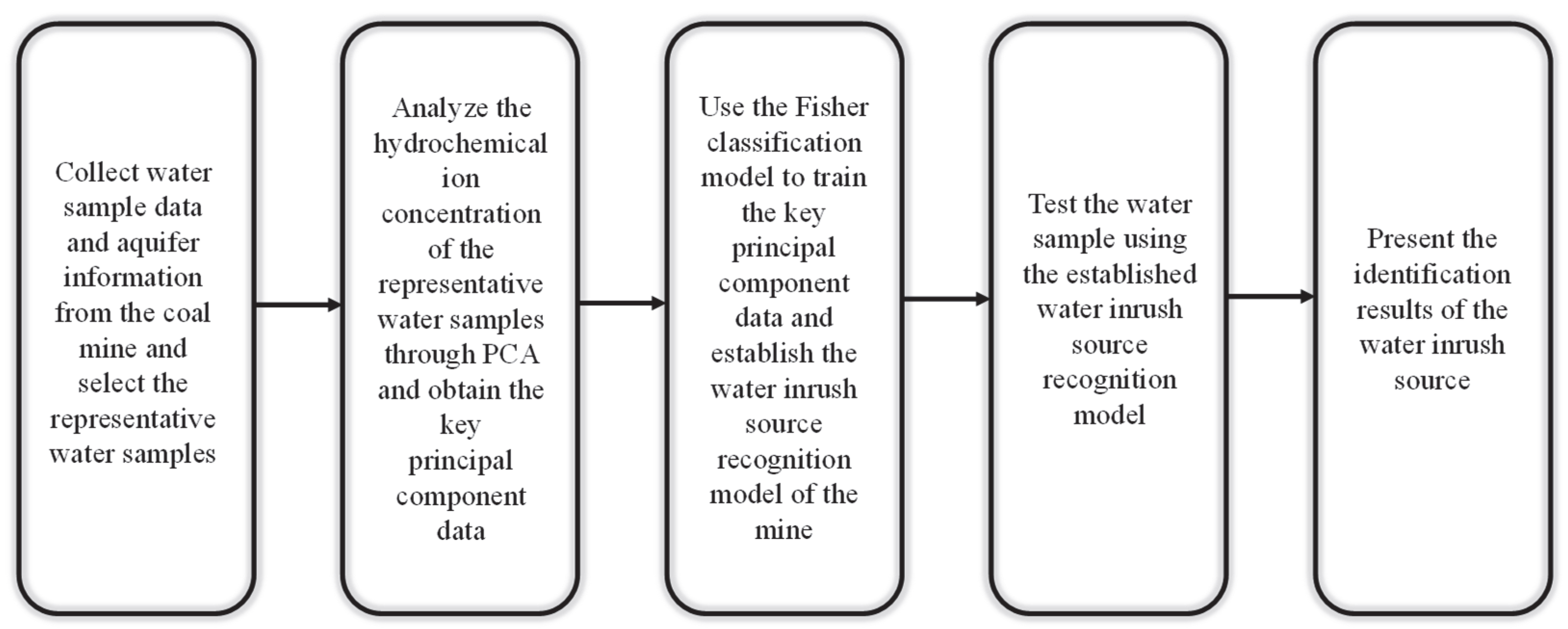

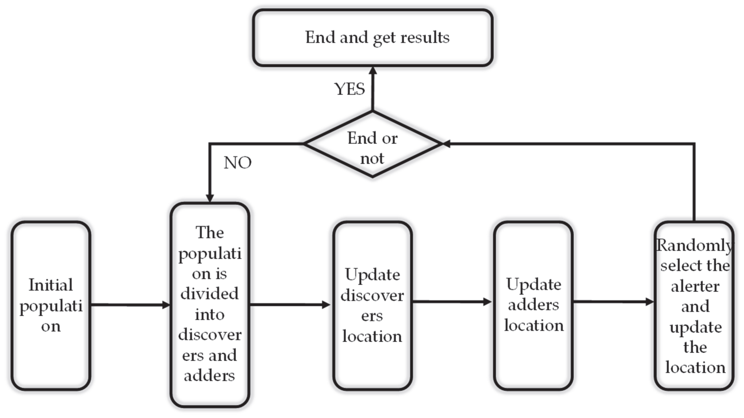

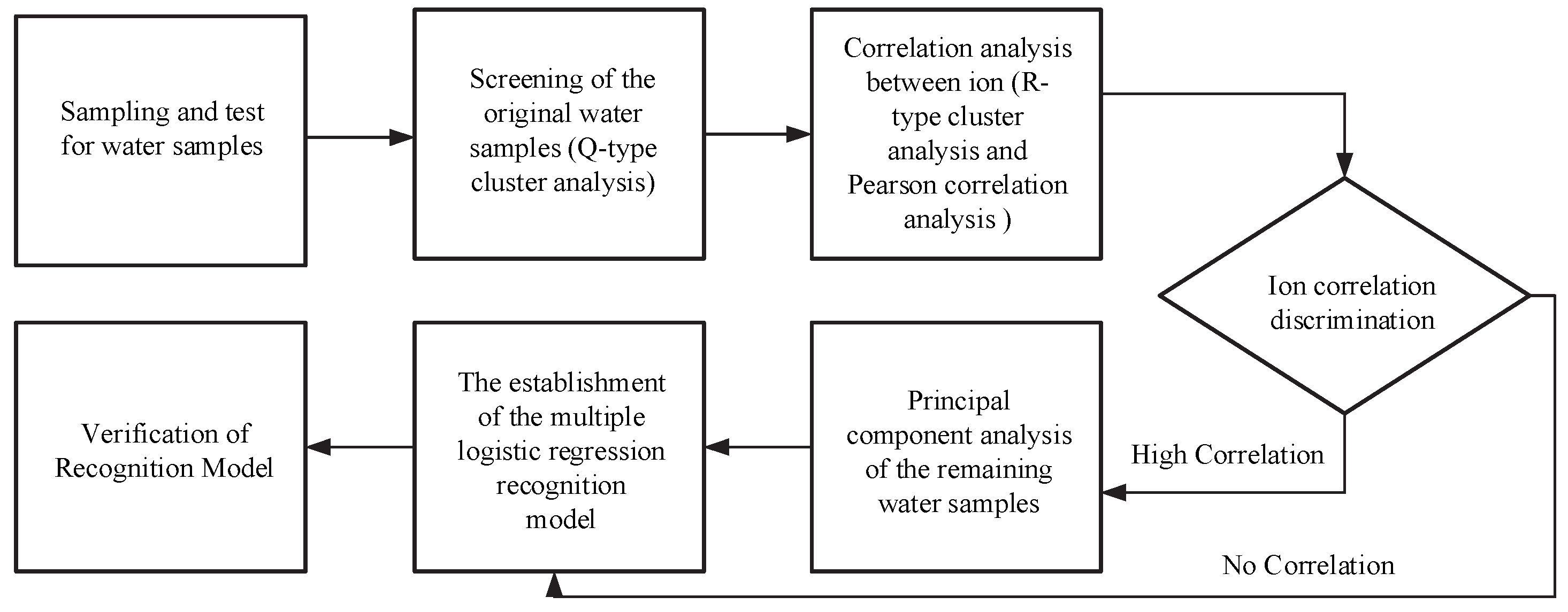