1. Introduction
The arid region of northwest China is short on water resources and has a fragile ecological environment [
1]. As an active natural resource, water resources play an important role in supporting the economic, social, and ecological civilization construction of arid areas. Water resources in arid areas have their own unique formation and evolution modes, mainly forming in mountainous areas, dissipating in plains, and existing in various forms such as precipitation, glacial meltwater, surface water, groundwater, etc. The groundwater and surface water in the basin show a huge amount of mutual transformation [
2,
3,
4]. It is of great significance to scientifically understand the water cycle mechanism of the basin, make full use of the function of large-thickness aquifer regulation and storage, and realize the joint storage and utilization of groundwater and surface water for the sustainable utilization of water resources in arid areas [
1,
2,
3,
4,
5].
The Heihe River Basin (HRB) is the second-largest arid inland river basin in China, and its water cycle and water resource characteristics have always been the research hotspots of domestic and foreign scholars [
6,
7]. Numerical simulation is an effective means to carry out relevant research, and groundwater models, including groundwater models, soil water and groundwater coupling models, and surface water and groundwater coupling models in different regions of the HRB, have been established. Based on the groundwater model, the relationship between base flow and recharge in mountainous areas in the upper reaches of the Heihe River [
8], groundwater equilibrium and water cycle evolution under water resource management scenarios such as the history and future of agricultural irrigation and water conservation in the middle reaches of Zhangye Basin [
9,
10], and the eco-hydrological effect of Ejina Banner under environmental flow management of the Heihe River downstream were studied [
11]. Based on the SWAT model and intelligent optimization, the optimal allocation of agricultural water and soil resources in the middle reaches of the HRB and Zhangye areas was studied [
12]. The coupling model of soil water and groundwater was used to study the water cycle process in Zhangye area under historical and future water-saving scenarios [
13], and the soil water balance model and numerical model of farmland gas wrapping zone based on empirical assumptions were used to study the soil water balance in Zhangye agricultural irrigation area [
14]. The eco-hydrological model is used to evaluate the water cycle flux in the middle and lower basins of the HRB [
15], and the role of groundwater in the eco-hydrological system of the middle and lower basins [
16]. Based on the coupling model of surface water and groundwater, the water use contradiction and water cycle flux of agriculture and ecosystems in the middle reaches of the Heihe River Basin and Yanchi Basin were studied [
17], and the relationship between surface water and groundwater transformation was studied [
18]. The coupling model of eco-hydrology and socio-economy at the basin scale was used to study multiple eco-hydrological processes in the basin and deepen the understanding of the coupling relationship between water, soil, atmosphere, vegetation, and humans in the arid basin [
19].
The accuracy of water recycling resources is key to the effectiveness of numerical models. In the middle reaches of the HRB, the water cycle mainly includes river runoff, water diversion, and extraction, among which river runoff can be used to calculate river seepage and groundwater discharge [
3,
4]. The amount of river leakage depends on the amount of water coming from the river, the length of the riverbed, the leakage capacity, etc. Through the preliminary geological survey work, empirical functions such as the power function regression equation of the leakage rate per unit length of the Heihe River channel and the power function of the incoming water have been established, and the curves of the cumulative discharge of groundwater and the discharge per unit length of the midstream basin have also been obtained [
3,
4,
20,
21,
22]. Water diversion and extraction quantities can be used to calculate irrigation channel leakage and field infiltration quantities. The preliminary work summarized the relationship between irrigation channel leakage and the lithology of the unsaturated zone, canal lining, groundwater depth, and the relationship between field infiltration and stratum lithology, irrigation water quantity, and burial depth of water level.
Climate change is a global issue of universal concern in today’s society. In the past century, major changes have taken place in the global climate and environment, whose main feature is global warming [
23], which has had an important impact on the global water cycle [
24]. Due to the fragile ecological environment in northwest China, climate change prediction is extremely important for maintaining water security, ecological security, and food security in the region. Global climate models (GCMs) are currently an effective tool for predicting climate change [
25]. GCMs can better simulate the characteristics of large-scale meteorological elements, but they are difficult to directly apply to meteorological and water resource prediction at the basin scale because of their low spatial resolution [
26]. The downscaling method can transform large-scale, low-resolution global climate models into small-scale, high-resolution regional climate information [
25], which has the advantages of a simple method, a small calculation amount, and no need to consider boundary conditions. It is widely used in China and abroad [
27].
In the past 33 years, the HRB has experienced the most fluctuating hydrological change process in the dry period and the most abundant period since observation data was obtained. The cultivated land area has continued to expand, the water-saving level of agricultural irrigation has increased, the water consumption has changed significantly, and the water cycle has new characteristics. In order to deepen the understanding of the mechanism of the long hydrological cycle and future changes in water resources in the basin of the middle reaches of the HRB under the conditions of climate change and human activities, based on the latest 1:50,000 hydrogeological survey, National Natural Science Foundation projects, groundwater monitoring, and other multi-source data, this paper further analyzes the characteristics of the river–aquifer system in the middle reaches of the HRB. Based on the new observation data at the turning point of river leakage and groundwater discharge to the river, the law of river leakage in the middle reaches of the Heihe River is recognized, and a coupled numerical model of surface water and groundwater on a long time scale is constructed based on multi-source data. The process and trend of the water cycle in the study area are studied, and the reasons are analyzed. The statistical downscaling model is used to predict the future precipitation in both the upper and middle reaches of the HRB, and then the mountain runoff is estimated. Three future climate change scenarios are constructed, and the future changes in water resources in the study area are predicted by numerical models. The dynamic changes in groundwater levels, groundwater storage, and Zhengyixia station runoff are analyzed. The rationality of the development and utilization of water resources in the basin is judged, and the problems that should be paid attention to in the sustainable utilization of water resources are put forward so as to provide reference for the sustainable utilization of water resources in the arid inland river basins.
3. Materials and Methods
3.1. Data Source
Over the years, the natural resources department, the water resources department, the meteorological department, and the Chinese Academy of Sciences have carried out a lot of work in the Heihe River Basin. Among them, the representative research projects in recent years include the 2014–2018 “Hydrogeological Survey of Key Areas in the Heihe River Basin” and “1:50,000 Hydrogeological Survey of the Heihe River Basin in the Hexi Corridor” by the China Geological Survey, the 2010–2017 Major Research Plan “Integrated Study of Ecological-Hydrological Processes in the Heihe River Basin” funded by the National Natural Science Foundation and the National Groundwater Monitoring Project launched in 2015. Based on the above-mentioned work, a groundwater, water conservancy, and remote sensing monitoring network for the Heihe River Basin has been established, constituting rich groundwater, surface water, water resource development and utilization, land use, and evapotranspiration data. On the basis of various types of hydrogeological drilling and geophysical prospecting results, the relationship between the mountains and the basin, as well as the hydrogeological conditions of the basin, are deeply investigated. A multi-layer, layered pumping system a layered monitoring scientific test base, and a test site for hydrological parameters such as infiltration coefficient are built to update the key hydrological parameters of the basin [
28,
29]. The above resources provide abundant basic data for this study.
The monthly hydrological data from 1990 to 2022 on the runoff of the Yingluoxia hydrological station, the Zhengyixia station of the Heihe River, and the Yinggezui station of the Liyuanhe River comes from Zhangye Hydrological Station (Zhangye, China). The monthly data from 1990 to 2020 on the development and utilization of water resources, such as surface water diversion and groundwater extraction quantity in each irrigation area, are from the Zhangye Water Bureau (Zhangye, China). Groundwater level dynamics and groundwater flow fields are from the China Institute of Geo-Environment Monitoring (Beijing, China).
The water resources forecast period is 2023–2055, including three future climate change scenarios. The first one is a historical reappearance scenario, that is, natural conditions such as mountain runoff and rainfall use data from 1990 to 2022 to reproduce the dry-to-flood season process in the HRB. The other two are climate prediction scenarios, namely the CNRM-CM5 model RCP4.5 and RCP8.5 pathways scenarios of CMIP5. The development and utilization of water resources, such as water diversion and groundwater exploitation in irrigation areas, are all reappearances of current data in 2020.
The climate prediction data includes three kinds of data: meteorological station measurement data (China Meteorological Data Network, Beijing, China), global atmospheric NCEP reanalysis data (NOAA, Washington, DC, USA) and CMIP5 climate model prediction data (Lawrence Livermore National Laboratory, Livermore, CA, USA).
3.1.1. Heihe Mountain Runoff
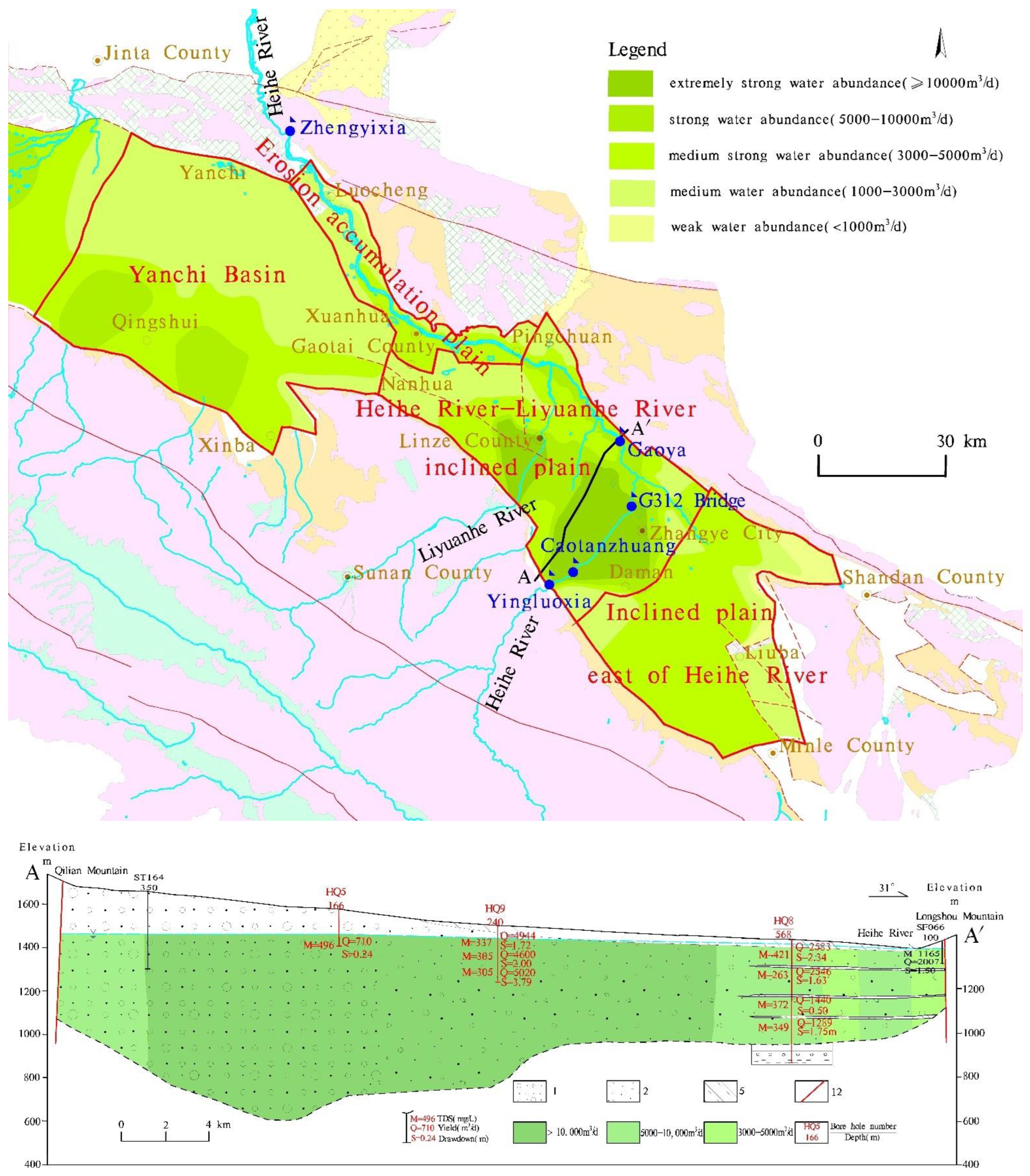
The observation section of the runoff from the Heihe River is the Yingluoxia hydrological station (
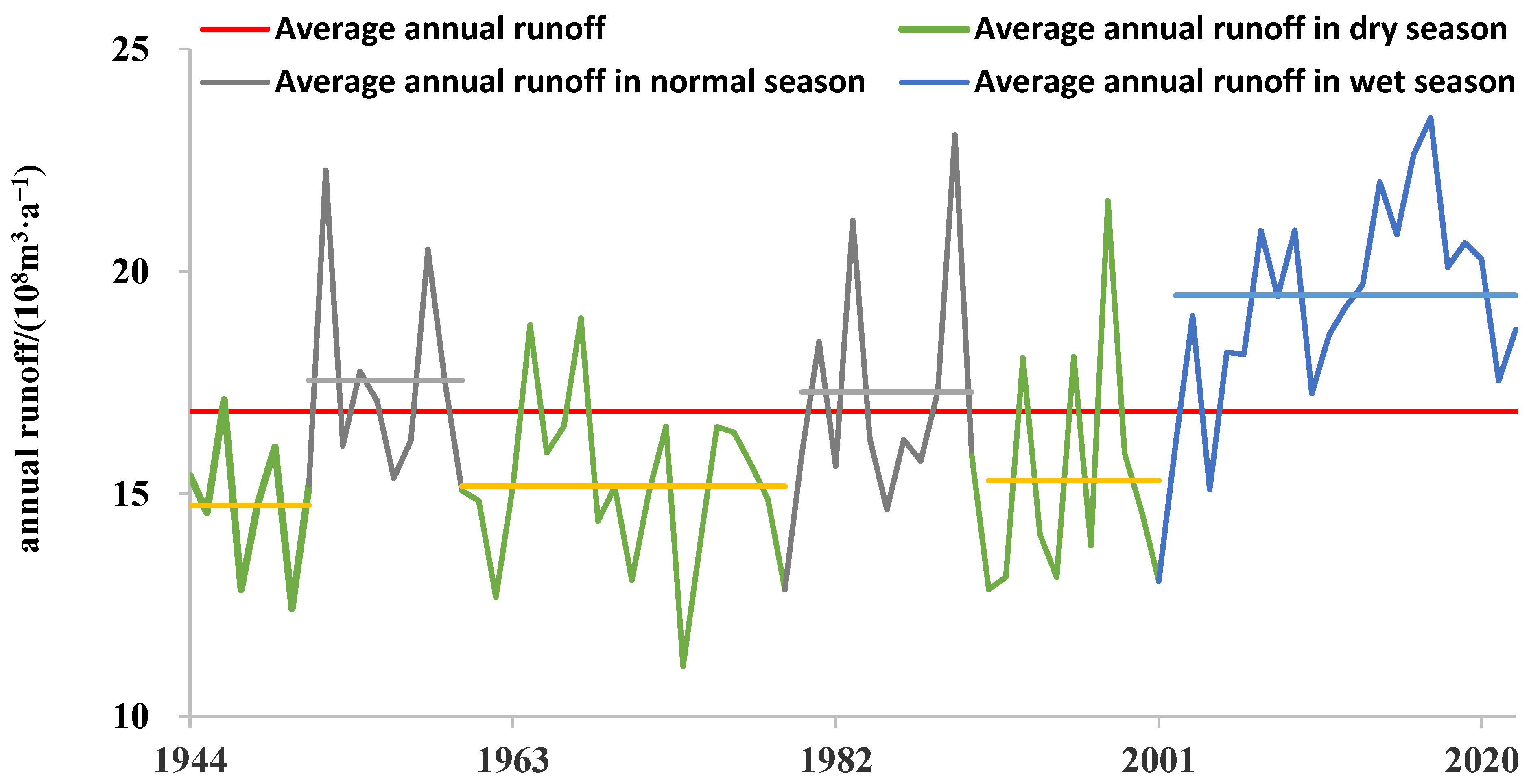
Figure 2), and the multi-year runoff dynamics of this station show the characteristics of alternating dry-flat-dry-flat-dry-abundant (
Figure 2). The period from 1990 to 2022 is a dry period up to 33 years, of which 1990–2001 is a dry period and 2002–2022 is a flood period, which is very typical. The multi-year dynamic changes in the difference between the runoff of Yingluoxia and the runoff of Zhengyixia in the Heihe River roughly reflect the change in water consumption scale in the middle basin, dominated by agricultural irrigation.
3.1.2. Heihe River Leakage
In the middle basin of the Heihe River Basin, there is a huge amount of groundwater and surface water conversion, of which the leakage of the Heihe River and the discharge of groundwater through the river channel are the main manifestations. The infiltration section and discharge section of the main stream of the Heihe River in the Zhangye Basin are roughly bounded by the G312 bridge, also known as the turning point of groundwater and surface water conversion, which is located about 1 km upstream of the G312 bridge. The Yingluoxia–G312 bridge section is the seepage section of the hanging river, including the Yingluoxia–Caotanzhuang section and the Caotanzhuang–G312 bridge section, and the river infiltration and replenishment are mainly controlled by the actual water flow into the river. The G312 bridge–Zhengyixia section is a groundwater discharge section. Based on such observational data as hydrological station runoff, irrigation channel diversion, G312 section runoff, and evaporation in the Heihe River–Zhangye Basin, the water leakage law of the Heihe River is analyzed by the river water balance method in order to obtain the river water leakage amount over the years [
30].
In 1990–2020, the runoff from Yingluoxia was 17.96 × 10⁸ m3/a. Under the current conditions of water resource development and utilization, the annual average river water leakage of the Yingluoxia–G312 Heihe bridge section was 7.11 × 10⁸ m3/a, accounting for 39.59% of the total runoff of Yingluoxia. The annual average infiltration of Yingluoxia–Caotanzhuang was 2.48 × 10⁸ m3/a, and the annual average infiltration of Caotanzhuang–G312 bridge was 4.63 × 10⁸ m3/a. The annual average water intake was 6.68 × 10⁸ m3/a, accounting for 37.19% of the runoff from Yingluoxia. The discharge under the transformation section was 4.02 × 10⁸ m3/a, accounting for 22.38% of the runoff from Yingluoxia. Compared with the natural conditions, the amount of water flowing through the river is reduced under human activity conditions, and the leakage and recharge rate of the river channel increase.
3.1.3. Groundwater Lateral Runoff Discharge to the Plain of the Southern Qilian Mountain
The amount of lateral runoff recharge to plain areas by mountain groundwater in the arid inland basin of northwest China has long been controversial, and this amount has been estimated to be small or large. Combined with the latest geo-hydrogeological survey, geophysical prospecting, drilling, pumping test, groundwater dynamic observation, water chemistry test, basin groundwater level measurement, and comprehensive research, the multi-year average lateral runoff recharge of groundwater in the plain area of Qilian Mountain is estimated to be 0.77 × 10
8 m
3/a, the recharge of runoff in the shallow mountain zone is 0.40 × 10
8 m
3/a, the lateral recharge of bedrock in the valley section is 0.07 × 10
8 m
3/a, and the recharge of the fourth series in the valley section is 0.30 × 10
8 m
3/a. The total recharge accounts for about 3.0% of the basin’s groundwater resources [
31].
3.1.4. Infiltration Replenishment Coefficient
Irrigation water and rainfall infiltration recharge are important sources of groundwater recharge in arid endorheic basins. For a long time, infiltration recharge was calculated using empirical parameter methods, lacking mature monitoring methods and empirical data. Based on the artificial bromine tracing method, the infiltration and recharge coefficients of three irrigation conditions and natural precipitation conditions in the middle reaches of the Heihe River were determined. The infiltration recharge coefficients under large-flood irrigation, small-flood irrigation, and drip irrigation were 0.16, 0.07, and 0.11, respectively, and that is 0.1 under natural precipitation conditions [
32].
3.1.5. Hydrogeological Structure and Parameters
Among the 314 boreholes in the middle reaches of the HRB, 98 core boreholes were selected, and the total drilling advance was 17,632.27 m, of which the deepest Quaternary borehole was 570.34 m. The hydrogeological structure of the basin was identified based on boreholes and geophysical data [
28,
33]. The hydrogeological parameters of the basin were updated based on the pumping test data [
23,
24]. At the top of the alluvial fan of the Qilian Mountain and the Northern Longshou Mountain, etc., the aquifer is a single phreatic aquifer, and the fine soil plain area is a multi-layer aquifer. The main lithology of the basin is pebbles and gravel, with a little sand, sub-sandy, and sub-clay. The groundwater storage space in the midstream basin is huge.
3.1.6. Distribution of Cultivated Land Area
There are a total of 35 irrigated areas in the study area. In the inclined plain north of the Qilian Mountain, the groundwater is buried deeply, and irrigation mainly relies on surface water; the buried depth of groundwater decreases along the north direction, and the amount of groundwater extraction increases, which constitutes the agricultural irrigation water source together with surface water. At the spring discharge area, the proportion of spring irrigation increased, and the Wujiang irrigation area was totally a spring irrigation area.
3.1.7. Climate Prediction Data
The meteorological data comes from the China Meteorological Data Network, and the precipitation data from Qilian, Yeniugou, Shandan, Zhangye, and Gaotai stations is selected. The global atmospheric NCEP reanalysis data are from the global atmospheric NCEP reanalysis jointly released by the American Center for Environmental Forecast (NCEP) and the National Center for Atmospheric Research (NCAR). The alternative predictors of NCEP reanalysis data are land surface temperature (air), surface relative humidity (rhum), surface pressure (pres), sea level pressure (slp), surface wind speed (wspd), surface zonal wind speed (uwnd), surface meridional wind speed (vwnd), as well as temperature, relative humidity, wind speed, zonal wind speed, meridional wind speed, vertical wind speed (omega), and geopotential height (hgt) at 500/850 hPa. On the one hand, these factors affect the longitude and latitude of climate zonality by affecting the meridional and zonal distribution of atmospheric circulation. On the other hand, meteorological circulation factors such as wind speed, sea level pressure, convective temperature field, potential height field and surface temperature affect the diffusion and transport processes of water and heat and then affect the change in precipitation. The CNRM-CM5 model, which has less absolute error in precipitation simulation in the arid region of northwest China, was chosen [
34].
3.2. Hydrogeological Conceptual Model
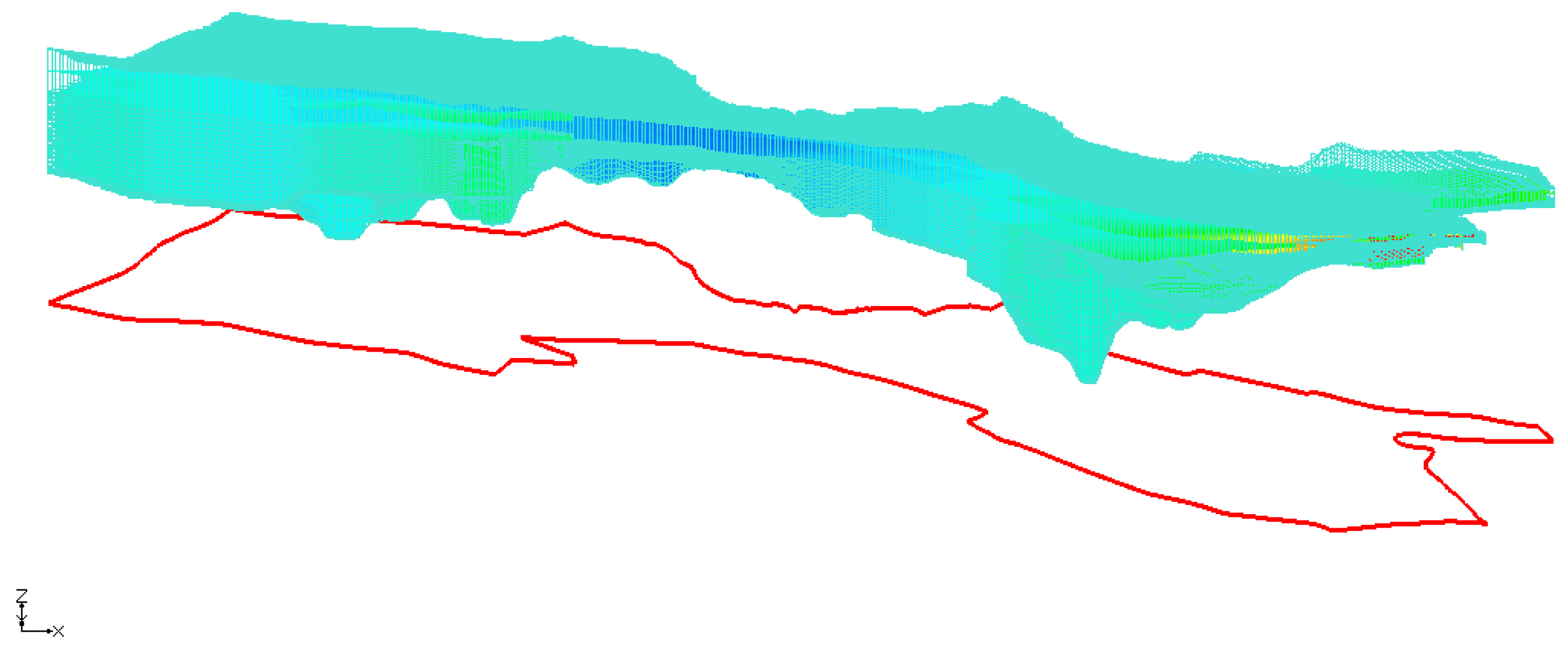
The middle basin of the HRB is a fault basin, and the north and south sides of the model are bounded by the piedmont reverse fault; the Eastern boundary of the model is bounded by faults; and the Western boundary of the model is the Western boundary of the Yanchi Basin. Vertically, the top boundary is the groundwater surface, and the bottom boundary is the Quartenary basal boundary. The model boundaries are all flow boundaries. Horizontally, the model area is split using a 500 × 500 m finite difference grid. Vertically, the model is divided into 20 layers (
Figure 3). The hydrogeological parameters, such as hydraulic conductivity, are given initial values first and then adjusted during model identification and validation.
The model recharge items included 8 items, namely rainfall infiltration recharge quantity (RCH), river seepage recharge quantity (RIV), irrigation canal seepage recharge quantity (CHA), canal irrigation (field) infiltration recharge quantity (CIR), well irrigation (field) recharge quantity (WIR), undercurrent lateral recharge quantity of the piedmont river valley (LRP), lateral recharge quantity of the piedmont non-river valley (LR), and spring water irrigation recharge quantity (SIR). The discharge items include three items, namely diving evaporation quantity (EVT), groundwater extraction quantity (WEL), and groundwater discharge quantity (GD).
The initial flow field of the numerical model is the flow field in January 1990. The simulation period is from 1990 to 2020, and the stress period is 1 month. The sources and sinks, water resources, and other elements of the water cycle are constant during each stress period.
3.3. Mathematical Model
The numerical model of groundwater flow in this study is a heterogeneous anisotropic transient three-dimensional flow model that is simulated using the MODFLOW-2005 simulation program issued by the United States Geological Survey [
35]. The mathematical model of groundwater flow is:
In the equation: —seepage area: —aquifer head (m); —diving surface; —bulkhead; —yield of water (−); —water storage rate (1/m); —horizontal permeability coefficient; —vertical permeability coefficient (m/d); —diving surface source sink term (m/d); —groundwater pumping source sink term (1/d); —initial water level of the aquifer (m); —second boundary; —the outer normal direction of the second boundary; and —specific discharge of the second boundary (m/d).
The mathematical model of river flow in the study area is:
In the equation: —the flow of the Heihe River, which varies with time and distance; —inbound flow of Heihe River (Yingluoxia); —the exchange intensity between Heihe River and aquifer (gain from groundwater is positive, loss to groundwater is negative); —distance along the Heihe River; —inflows of tributaries along the Heihe River (inflow is positive, outflow is negative); —the distance of the tributaries along the Heihe River.
3.4. Statistical Downscaling Model
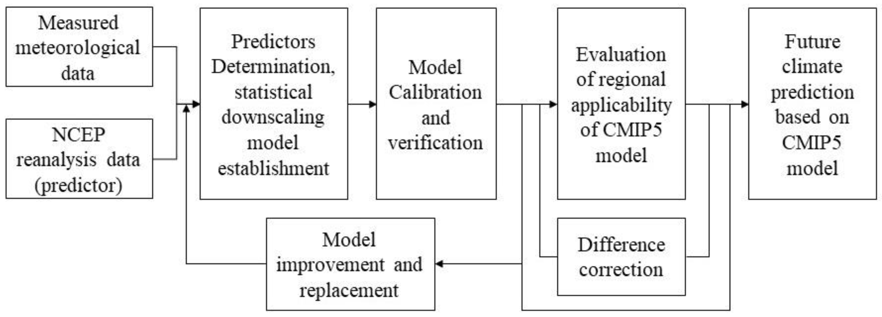
Firstly, the statistical downscaling model is used to predict the future precipitation of the basin, including the upstream precipitation that determines the mountain runoff, as well as the precipitation in the study area. Secondly, mountain runoff is predicted. The essence of the statistical downscaling model is to establish a significant relationship between climate forecasting factors and regional meteorological elements. The process of establishing the future climate change prediction of the CMIP5 model through the statistical downscaling model is shown in
Figure 4. The data period used to establish the model is from 1960 to 2014, including 1960–2005 for model calibration and 2006–2014 for model verification.
3.4.1. Prediction Factor Selection
The steps of selecting forecasting factors are as follows: first, all candidate factors are screened by the stepwise regression method, and the collinearity of the included factors in the regression equation is checked. Secondly, for similar factors with significant collinearity, according to their correlation and partial correlation with the predicted quantity, the factors with greater correlation are selected. Thirdly, after collinear exclusion, if there are still too many prediction factors in the regression equation, the standardized coefficient in the equation is small, i.e., the factors that have little influence on the prediction.
3.4.2. Multiple Regression Downscaling Model
The multiple regression downscale model of forecast factor and forecast quantity is established, and the sub-rate is predicted periodically and in the verification period, in which the prediction threshold of precipitation is set at 0.2 mm, i.e., no precipitation occurs in that month when the monthly precipitation is less than 0.2 mm. The degree of fitting of the monthly value and the relative error of the annual value are selected as indicators to evaluate the simulation effect.
3.4.3. Supplementary Multiple Regression Downscaling Model
The residuals of simulated and measured precipitation at periodic stations are calculated, and it is found that each residual can be well fitted by linear regression. Therefore, the deviation correction is carried out, and a supplementary multiple regression model based on residual analysis is established to improve the simulation effect of the downscale model of the HRB [
34].
3.4.4. Evaluation of Regional Applicability of CMIP5 Model
The simulation process of the Global Climate Model (GCM) is uncertain, so it is necessary to evaluate its regional applicability before using the GCM to predict the future climate. The starting time of CMIP5′s CNRM-CM5 model prediction is January 2006, so the prediction factors of the period from January 2006 to December 2014 are used to simulate the precipitation and temperature of each station according to the two models established above. Before simulation, the spatial resolution of the CNRM-CM5 model is adjusted to 2.5 × 2.5 by using the distance reciprocal weight interpolation method, which is consistent with the NCEP reanalysis data. Regional applicability evaluation is divided into two paths: RCP4.5 and RCP8.5.
3.4.5. Prediction of Future Precipitation
According to the downscaling model determined by regional applicability evaluation, the future precipitation of the basin is predicted under the two paths of RCP4.5 and RCP8.5.
3.4.6. Prediction of Future Runoff
According to the regression model of mountain runoff and precipitation in the upper reaches of the basin, the mountain runoff in the study area is estimated.
4. Results and Discussion
4.1. Calibration and Verification of Numerical Model
Using a variety of data, such as groundwater level dynamics, groundwater flow field, groundwater discharge along the river, annual groundwater discharge to the river, go runoff, etc., the model is calibrated and verified by manual and automatic parameter adjustments [
36]. The model calibration period is from 1990 to 2015, and the model verification period is from 2016 to 2020. Using Nash efficiency coefficients [
4], Taylor diagrams [
37], Box plots [
38], Radar charts [
39], and other statistics, the numerical model is considered effective in simulation [
30].
4.2. Groundwater Budget in the Midstream Basin
From 1990 to 2020, the average annual groundwater recharge in the study area was 17.98 × 10
8 m
3/a, the average annual discharge was 18.62 × 10
8 m
3/a, and the storage change was −0.58 × 10
8 m
3/a. From 1990 to 2001, the average annual groundwater recharge in the basin was 16.39 × 10
8 m
3/a, the average annual discharge was 17.85 × 10
8 m
3/a, and the storage change was −1.46 × 10
8 m
3/a. From 2002 to 2020, the average annual groundwater recharge in the basin was 18.98 × 10
8 m
3/a, the average annual discharge was 19.11 × 10
8 m
3/a, and the storage change was −0.13 × 10
8 m
3/a (
Table 1). The total groundwater storage change during the simulation period was −19.99 × 10
8 m
3, of which the groundwater storage change was −17.52 × 10
8 m
3 from 1990 to 2001 and −2.47 × 10
8 m
3 from 2002 to 2020.
The interannual fluctuation of groundwater recharge in the middle basin of the Heihe River Basin is large, while the interannual fluctuation of discharge is small (
Figure 5). This reflects the regulation and storage effect of the large-thickness aquifer system in the basin, and the interannual fluctuation of discharge is more stable than that of recharge after the adjustment of the aquifer. At the same time, groundwater discharge has a self-adaptation feature. For example, when the amount of groundwater extraction in the shallow buried area on both sides of the Heihe River increases, the groundwater discharge decreases accordingly, and the sum of the two reflects the macroscopic change in groundwater discharge in the midstream basin.
4.3. Influence Area of the Heihe River
Based on the groundwater flow field in typical years, the influence area of the Heihe River was identified (
Figure 6). From 1990 to 2001, due to the continuous drought in the HRB and the increase in groundwater extraction, the area affected by the recharge of the Heihe River decreased. From 2001 to 2014, the river basin turned from dry to wet, and the influence area increased. From 2014 to 2020, the HRB continued to be abundant in precipitation, and under the combined effects of mountain runoff, irrigation water diversion, and groundwater extraction, the area affected by the leakage of the Heihe River decreased slightly.
4.4. Proportions of Groundwater Discharge to the Heihe River
Four typical years were selected, and the multi-year variation in the proportions of discharge of the Heihe River from recharge of the Heihe River was analyzed by streamlining tracking (
Figure 7,
Table 2). Compared with the median water year in 1990, the proportion of leakage recharge of the Heihe River to the total recharge in the dry year of 2001 decreased from 36.92% to 34.22%, which was mainly affected by the decrease in mountain runoff. The ratio of discharge of the Heihe River to recharge of the Heihe River increased from 63.37% to 67.80%. The reason may be that, with the significant increase in groundwater exploitation in the irrigation area, more groundwater comes from storage nearby since the recharge area of the Heihe River is relatively far away. Compared with the dry year in 2001, the proportion of leakage recharge of the Heihe River in the 2014 wet year increased significantly, the discharge of the Heihe River increased, and the ratio of discharge in the Heihe River from recharge of the Heihe River also increased significantly. Compared with 2014, the mountain runoff in 2020 decreased, and the proportion of leakage recharge of the Heihe River to the total recharge also fell. In general, the larger the mountain runoff, the greater the proportion of leakage recharge of the Heihe River to the total recharge, and the greater the ratio of discharge of the Heihe River from recharge of the Heihe River.
4.5. Prediction of Mountain Runoff in the Watershed
According to the principle of prediction factor selection, the precipitation prediction factors of the Qilian station are air850, rhum500, and omega850, and the prediction factors of the Yeniugou station are air, rhum500, and omega850.
Based on the multiple regression downscaling model, the fitting degree of the monthly value of the precipitation rate is 0.536 to 0.837, and the verification period is 0.454 to 0.837. The relative error of the annual value of the precipitation rate is −22.17 percent, and the verification period is −43.47 percent. The overall fitting rate of the verification period is poor. For different stations, with the decrease in average annual precipitation, the fitting degree of the monthly value of the rate periodicity and the verification period becomes smaller, and the relative error of the annual value becomes larger. Generally speaking, there is a big error in the simulated precipitation values of each meteorological station during the verification period, and the simulated values are all smaller than the measured values, which cannot meet the prediction requirements.
The simulation effect of the precipitation supplementary regression model is obviously better than that of the multiple regression model, and the annual mean relative error of the simulation is obviously reduced. The annual mean relative error of the supplementary regression model rate of precipitation is −1.63~0.01%, and the verification period is −18.88~2.30%, which are significantly smaller than those of the multiple regression model.
The evaluation of regional applicability shows that under the two pathways, the simulation annual mean relative error of the supplementary regression models of precipitation is generally smaller than the multiple regression models. Under the two pathways, the simulated precipitation is higher than the measured value from January to April and from October to December and lower than the measured value from May to September. The simulation effect of the model for the annual distribution of precipitation is slightly poor, but the simulation effect for annual precipitation is better.
The mountain runoff of the Heihe River and other rivers is predicted according to the prediction of precipitation in the upper reaches of the HRB. Under the RCP4.5 scenario, the predicted annual runoff of Yingluoxia from 2023 to 2055 is 21.17 × 10
8 m
3/a, and that of Yingluoxia from 2023 to 2055 is 21.46 × 10
8 m
3/a under the RCP8.5 scenario (
Figure 8).
4.6. Groundwater Budget from 2023 to 2055
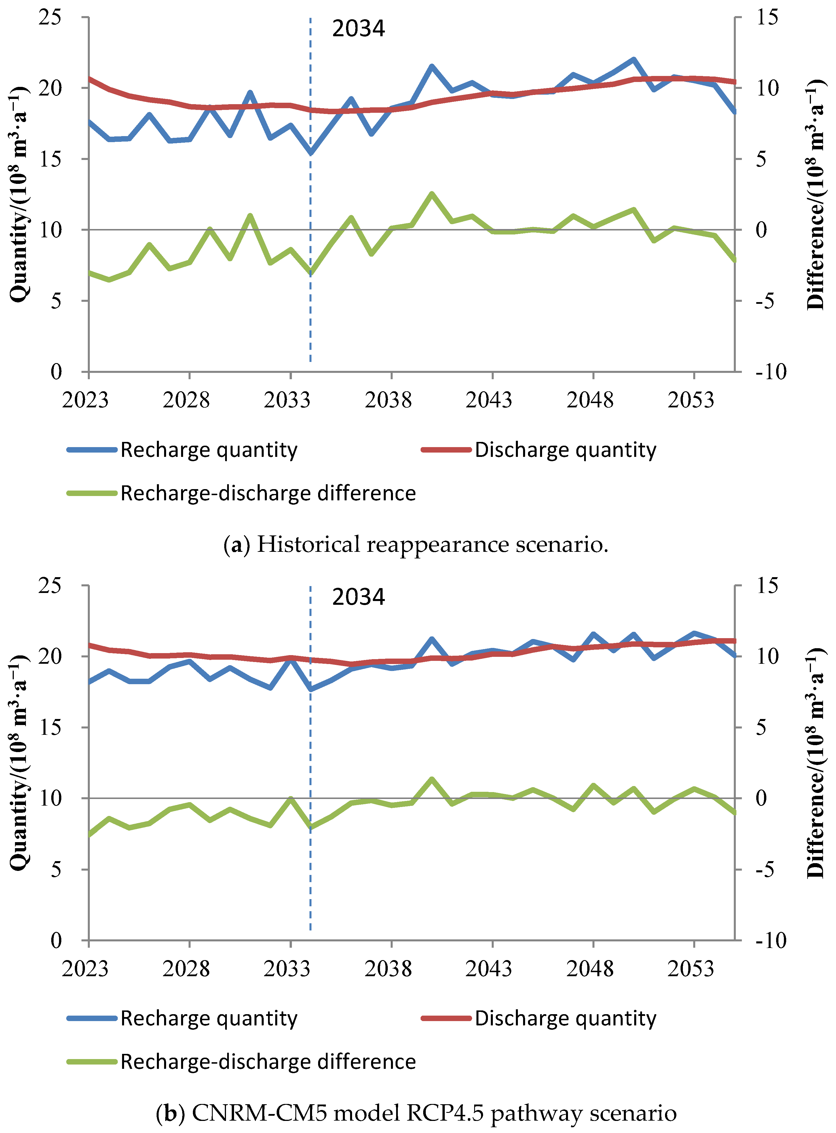
Under the predicted historical reappearance scenario, the average annual recharge of groundwater in the study area from 2023 to 2055 is 18.93 × 10
8 m
3/a, the average annual discharge is 19.59 × 10
8 m
3/a, and the difference between recharge and discharge is −0.66 × 10
8 m
3/a. Under the RCP4.5 scenario, the average annual recharge of groundwater in the study area from 2023 to 2055 is 19.67 × 10
8 m
3/a, the average annual discharge is 20.23 × 10
8 m
3/a, and the difference between recharge and discharge is −0.56 × 10
8 m
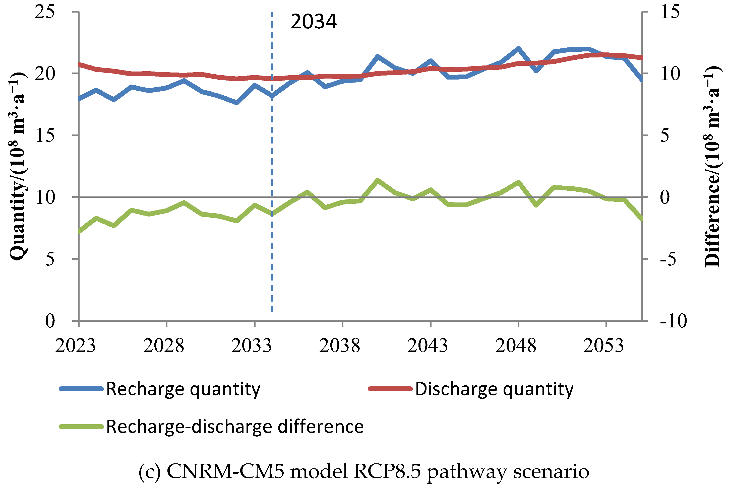
3/a. Under the RCP8.5 scenario, the average annual recharge of groundwater in the study area from 2023 to 2055 is 19.77 × 10
8 m
3/a, the average annual discharge is 20.30 × 10
8 m
3/a, and the difference between recharge and discharge is −0.53 × 10
8 m
3/a (
Figure 9).
4.7. Prediction of Groundwater Levels in the Middle Reaches of the HRB
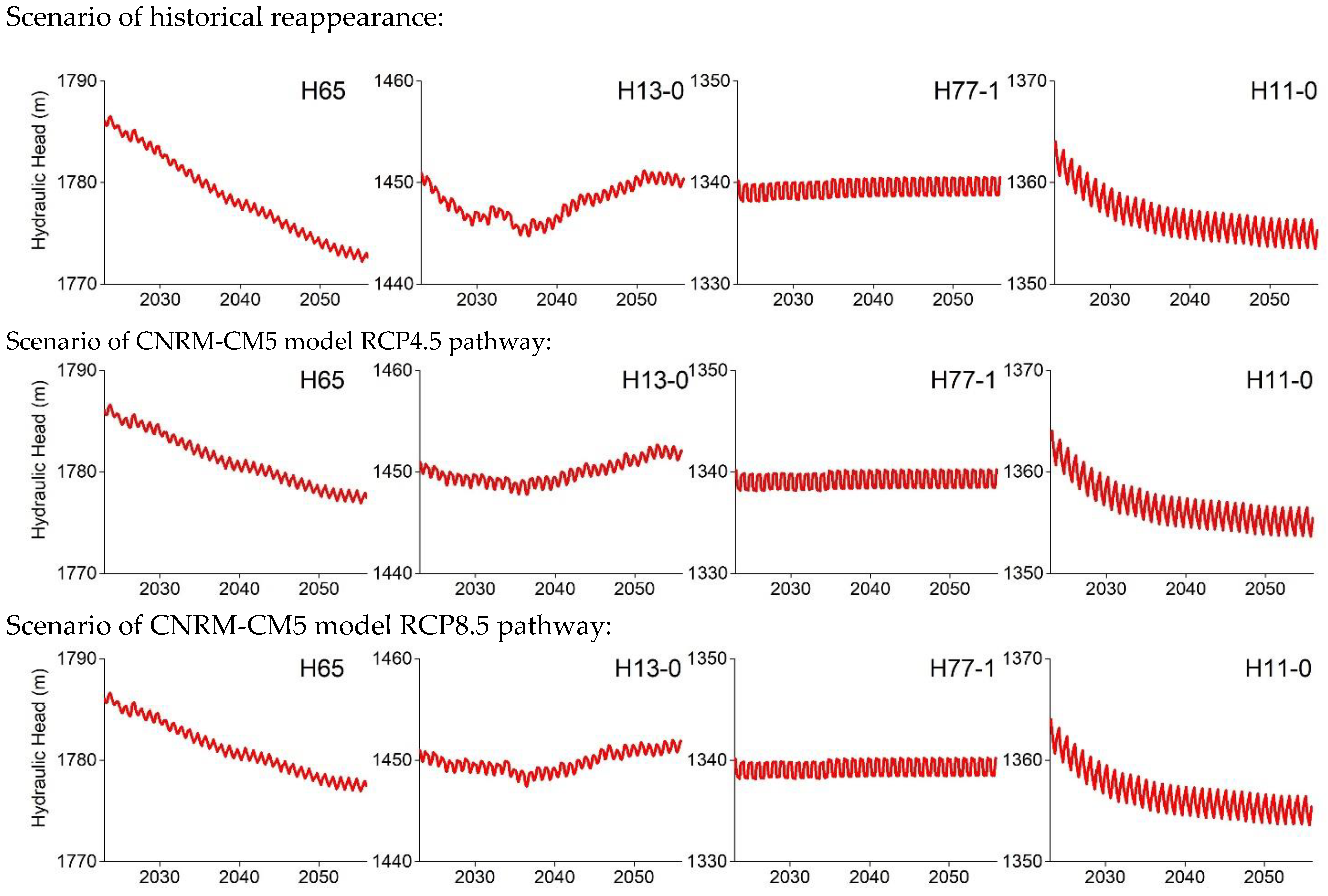
Under the three scenarios, the groundwater level in the inclined plain east of the Heihe River is in a state of continuous decline from 2023 to 2055, such as in the H65 observation hole, which is due to excessive surface water diversion and reduced groundwater recharge. Under the RCP4.5 and RCP8.5 scenarios, the water resources in the future basin increased, and the decline in groundwater level was significantly lower than that of the historical reappearance scenario. The groundwater level dynamics in the Heihe River–Liyuanhe River inclined plain are mainly affected by mountain runoff, and there is a certain trend of falling first and then rising in the future (H13-0). The falling process reflects the rise of the groundwater level during the strongest flood period from 2002 to 2022, and the rising process reflects the future increase in water resources in the basin. The erosion accumulation plain is located in the groundwater discharge zone of the midstream basin, and the groundwater table is basically stable, such as in the H77-1 observation hole. The groundwater level in the Yanchi Basin continued to decline, most typically in the Southern mountainous area, mainly affected by overexploitation in the irrigation area. For example, the continuous decline of the groundwater level in the H11-0 observation hole is due to the continuous exploitation of the Luotuocheng County irrigation area. Over time, the downward trend of H11-0 water level slowed down, which was due to the increase in lateral runoff recharge of groundwater caused by the decline of the groundwater table and the increase in the hydraulic gradient around the irrigation area. The downward trends of the groundwater levels in the Yanchi basin under the RCP4.5 and RCP8.5 scenarios are slower than those in the historical reappearance scenario (
Figure 10 and
Figure 11).
4.8. Groundwater Budget in the Midstream Basin
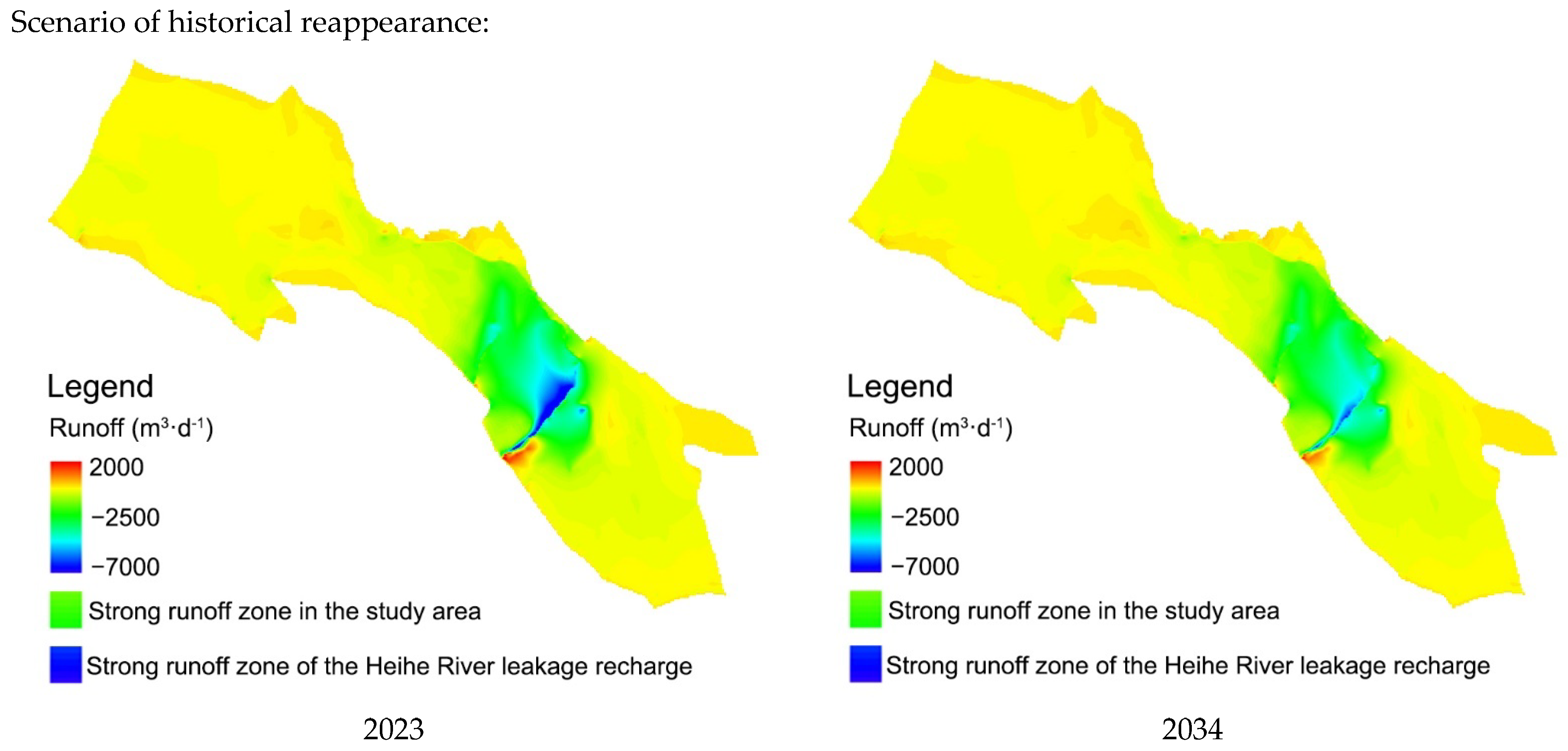
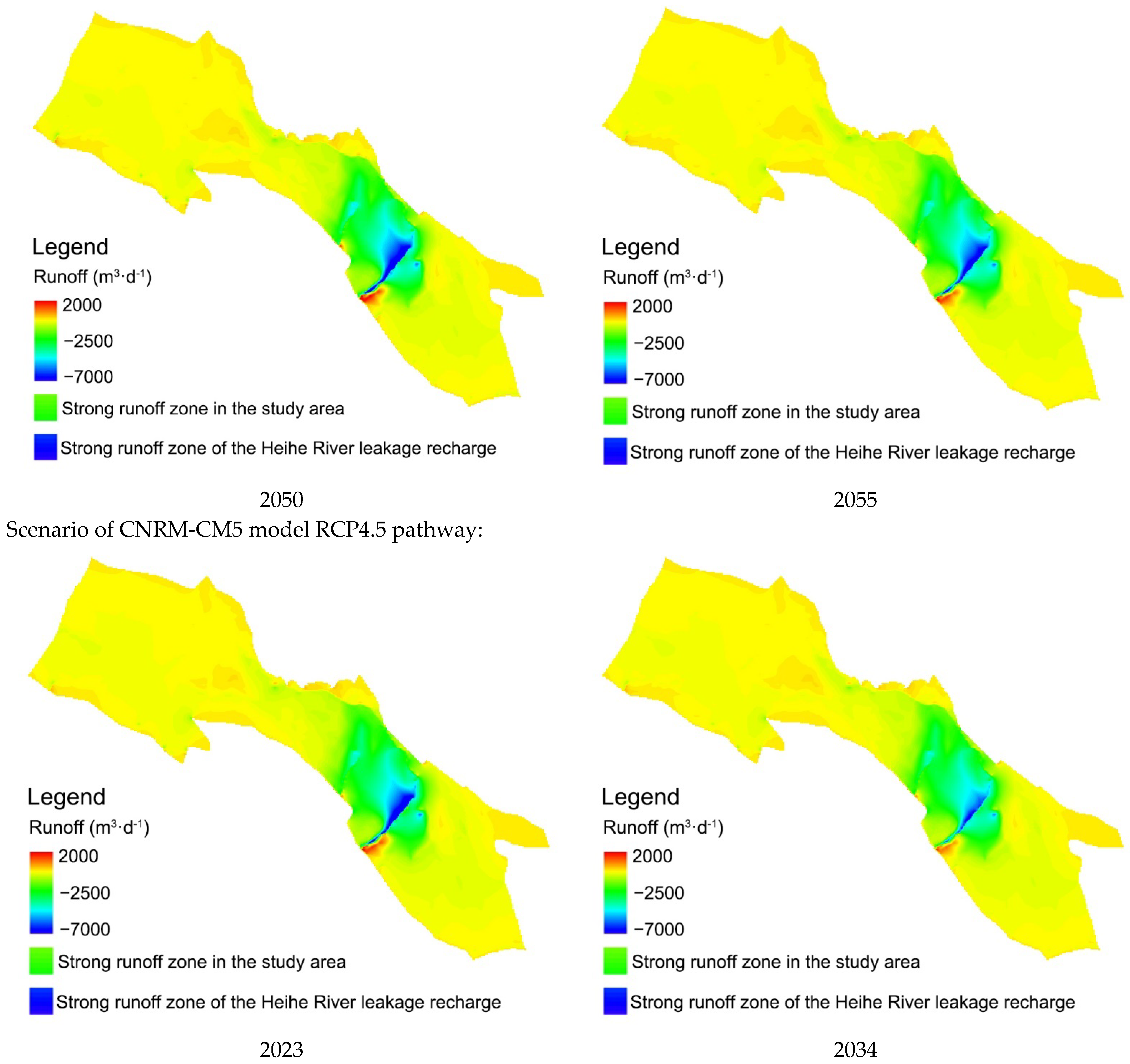
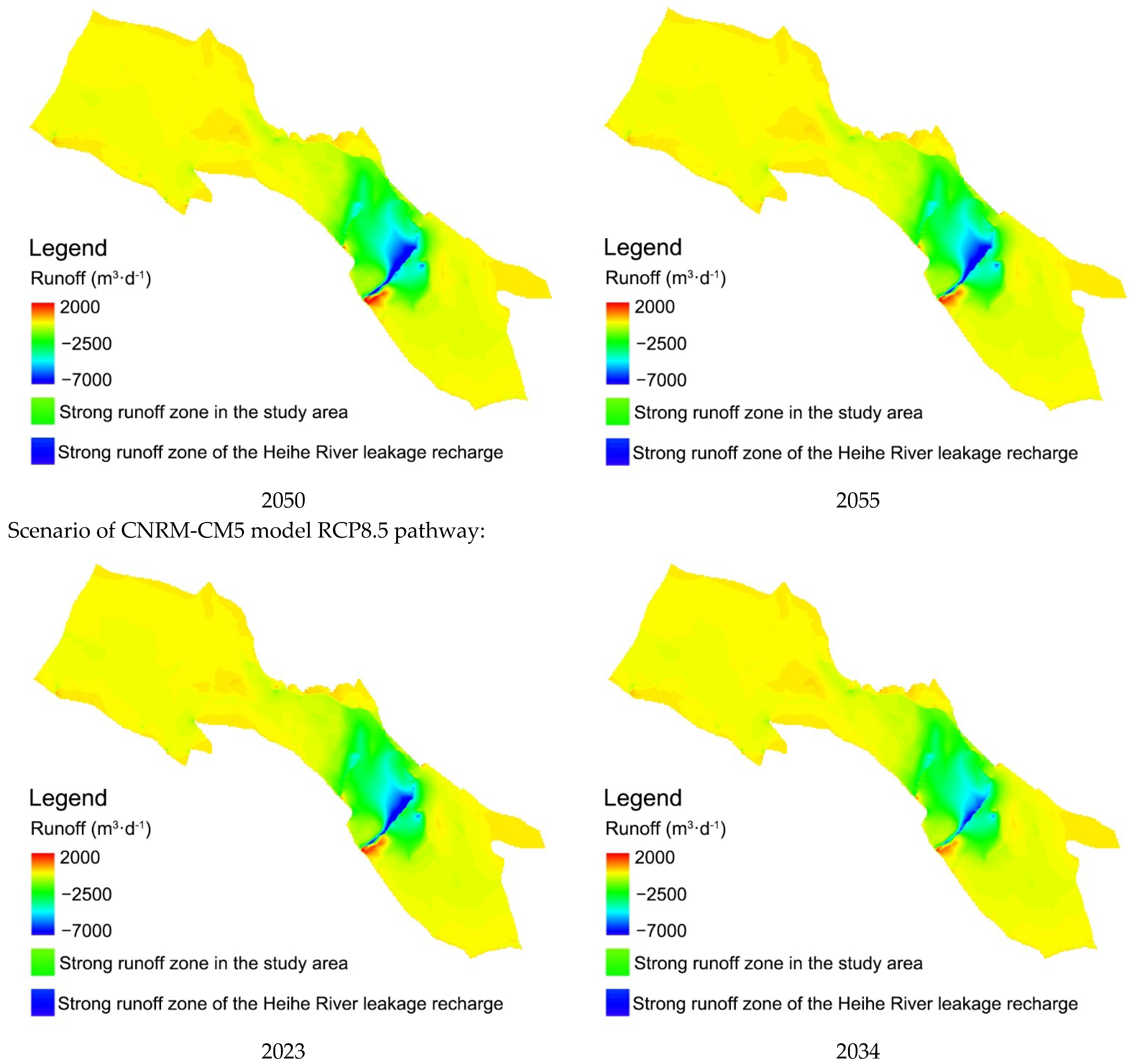
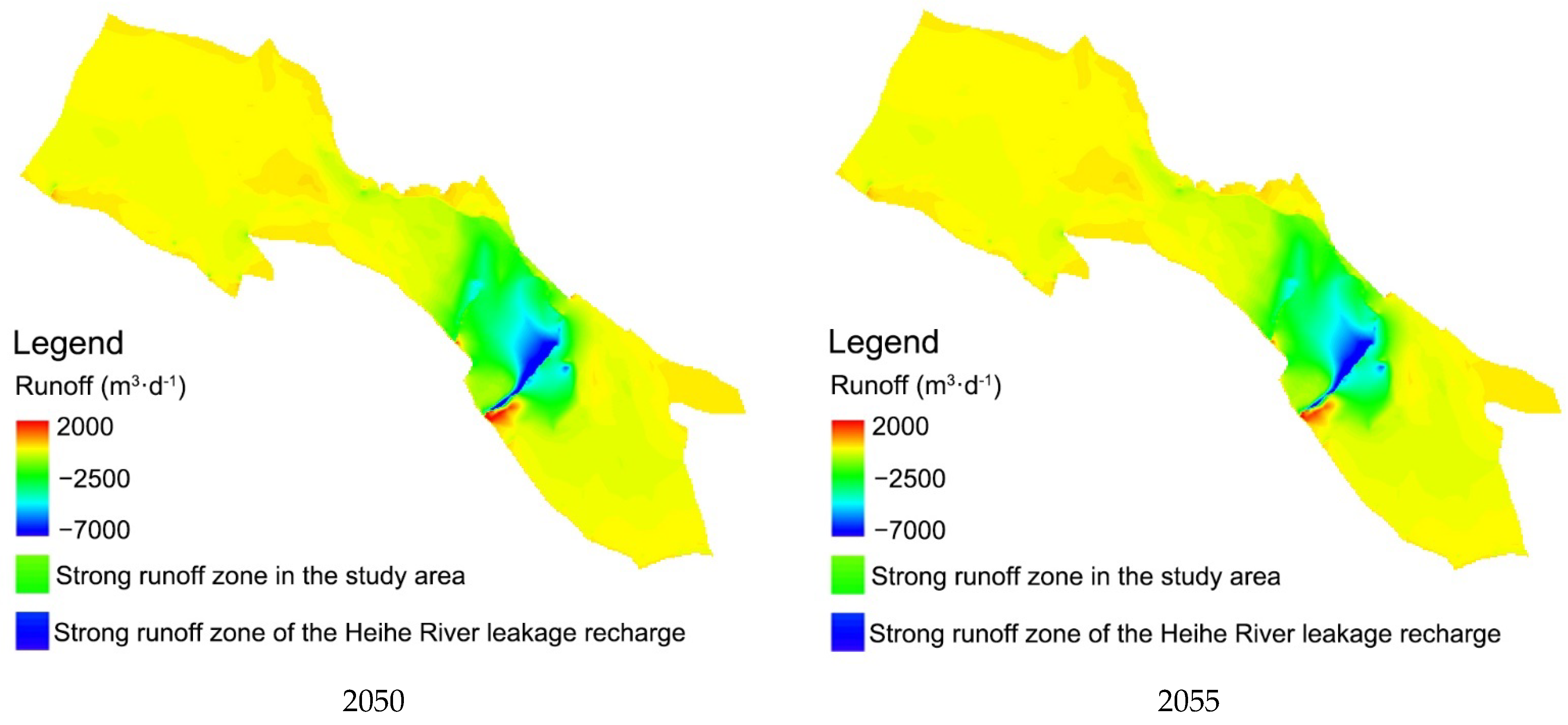
In the future, the strong groundwater runoff zone in the middle reaches of the HRB will change with the amount of water resources and human activity in the basin. In the flood year, the groundwater runoff is large, and the recharge characteristics of Heihe River leakage to groundwater are significant; in the dry year, the groundwater runoff is small, and the groundwater recharge caused by Heihe River leakage is relatively weak (
Figure 12).
4.9. Future Runoff of Zhengyixia
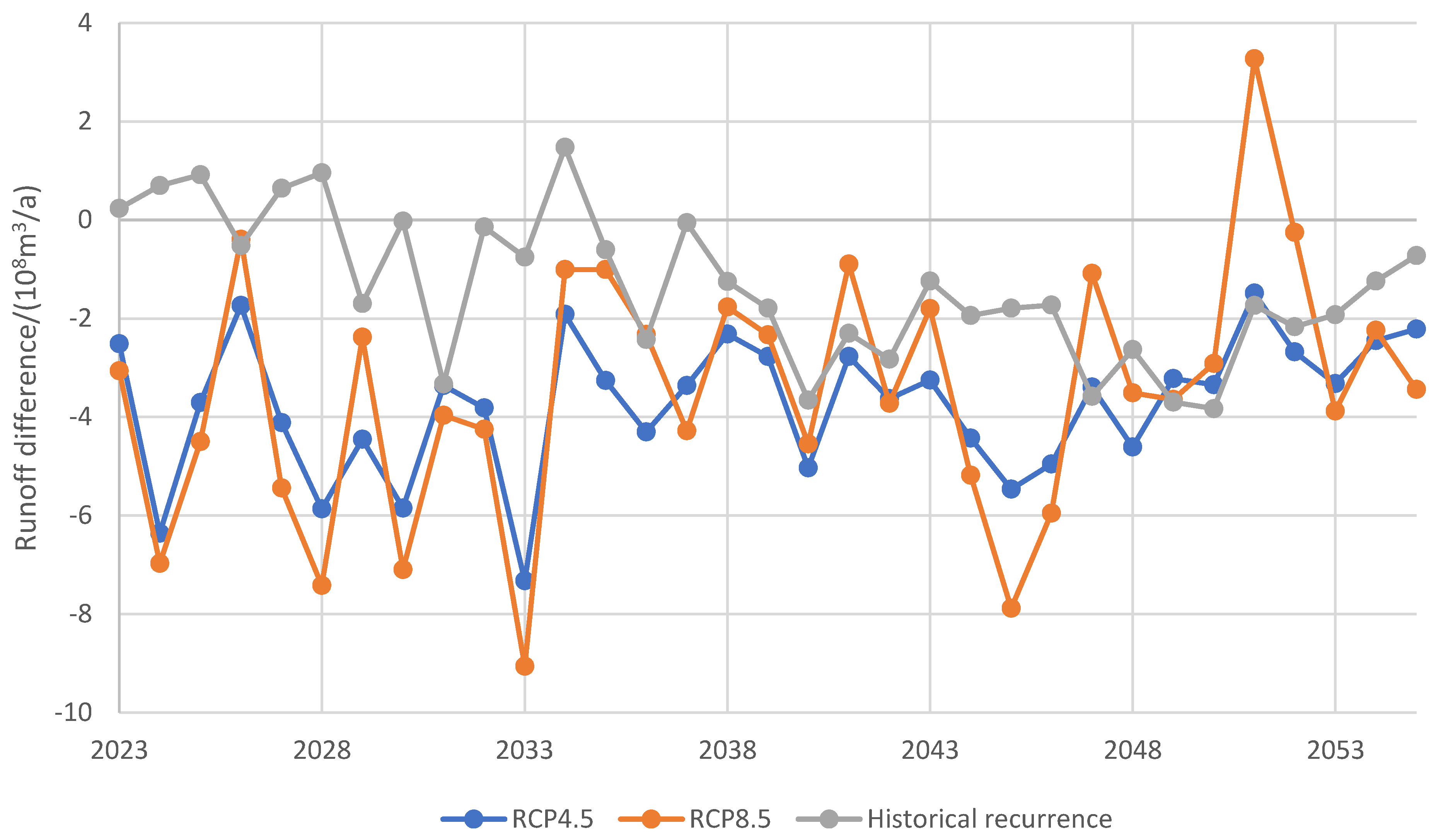
The “97 Water Diversion Plan” of the State Council stipulates the functional relationship between the runoff of Zhengyixia and Yingluoxia, so as to ensure a certain amount of runoff from Zhengyixia to the lower reaches of the HRB and safeguard the downstream ecology. Under the historical reappearance scenario, the annual average difference between the runoff of Zhengyixia and the dividing runoff amount in the future is predicted to be −1.35 × 10
8 m
3/a. Under the RCP4.5 and RCP8.5 scenarios, the differences between the two are −3.74 × 10
8 m
3/a and −3.48 × 10
8 m
3/a, respectively (
Figure 13). In the future, the basin will be in a wet period and will not be able to meet the “97 Water Diversion Plan” for many more years. In the previous study, with the implementation of the water-saving irrigation under the RCP4.5 and RCP8.5 scenarios, the runoff of Zhengyixia can meet the “97 Water Diversion Plan” from 2023 to 2033 continuously [
4]. It is suggested that the middle reaches of the HRB further improve the level of agricultural water saving and control the reasonable scale of cultivated land to reduce the water consumption of agricultural irrigation and ensure ecological water use in the lower reaches, aiming to realize the sustainable utilization of water resources in the basin.
5. Conclusions
Based on the latest hydrogeological survey and other multi-source data, this paper constructs a coupled numerical model of surface water and groundwater in the middle reaches of the HRB and analyzes the changing process of the water cycle. The future precipitation in the upper and middle reaches of the HRB is predicted by the statistical downscaling model, and the mountain runoff is predicted. Three future climate change scenarios are constructed, and the numerical model is used to predict the future change in water resources and judge the rationality of the development and utilization of water resources in the basin.
Under the combined influence of natural conditions and human activities, the average annual recharge of groundwater in the study area from 1990 to 2020 was 17.98 × 10⁸ m3/a, the average annual discharge was 18.62 × 10⁸ m3/a, and the difference between recharge and discharge was −0.64 × 10⁸ m3/a. The total groundwater storage change was −19.99 × 10⁸ m3, of which the groundwater storage change from 1990 to 2001 was −17.52 × 10⁸ m3 and from 2002 to 2020 was −2.47 × 10⁸ m3.
Under the scenarios of historical reappearance and RCP4.5 and RCP8.5 pathways of the CMIP5 CNRM-CM5 model, the groundwater level in the Heihe River–Liyuanhe River inclined plain falls first and then rises; the groundwater levels in the inclined plain east of the Heihe River and the Yanchi basin continue to decline; and the water level in the erosion accumulation plain is basically stable. In the future, the wet period will significantly improve the groundwater deficit in the basin. The future runoff of Zhengyixia cannot meet the requirements of the State Council’s “97 Water Diversion Plan” in most years, and the ecological and production water usage in the lower reaches of the HRB cannot be effectively guaranteed. With the implementation of the water-saving irrigation under the RCP4.5 and RCP8.5 scenarios, the runoff of Zhengyixia can meet the “97 Water Diversion Plan”.
The water resources in the inland river basin have multiple functions, such as resources, environment, ecology, etc. The middle reaches of the HRB should maintain a reasonable scale of land development, develop water-saving agriculture, appropriately return farmland to forest and grassland, protect wetlands and natural vegetation, reduce water consumption in the basin, and achieve water diversion and exploitation in an orderly manner to promote the coordinated and healthy development of hydrology, ecology, economy, and society in the inland river basins.

