1. Introduction
Many industries are currently being reshaped under digital twin schemes [
1] like manufacturing [
2,
3], and even phenomena like the COVID-19 pandemic are analyzed under this framework [
4]. The origins of this technology come from physical artifacts predominantly manufactured by artisans in the 18th century using interchangeable parts. Then, companies began mass building and producing copies of their products with the goal of achieving low-unit costs for customized products.
The word
twin refers to a copy of a part or product used to infer information about other samples of the same part or product with a relation among copies, and this originated from NASA’s Apollo program [
5]. Later, over the past decades, advancements in computer technology resulted in the sophisticated simulation of virtual models based on physical artefacts. These models serve the purposes of design [
6], manufacturing [
7], feedback from operating conditions [
8], and so on. Meanwhile, modern sensing routines make the collection of large sets of data from physical artefacts easy, quick, and reliable. And new data analysis approaches like pattern recognition, data mining, deep learning, and reverse engineering can unveil dependencies hidden to some extent [
1].
As a result, the digital twin model not only serves for representation but also for making predictions about expected product behavior [
9]. It is feasible and necessary to integrate all life-cycle data artefacts into a comprehensive management system, which would allow for various participants to become involved in product life-cycle management like design optimization and manufacturing system improvement [
5].
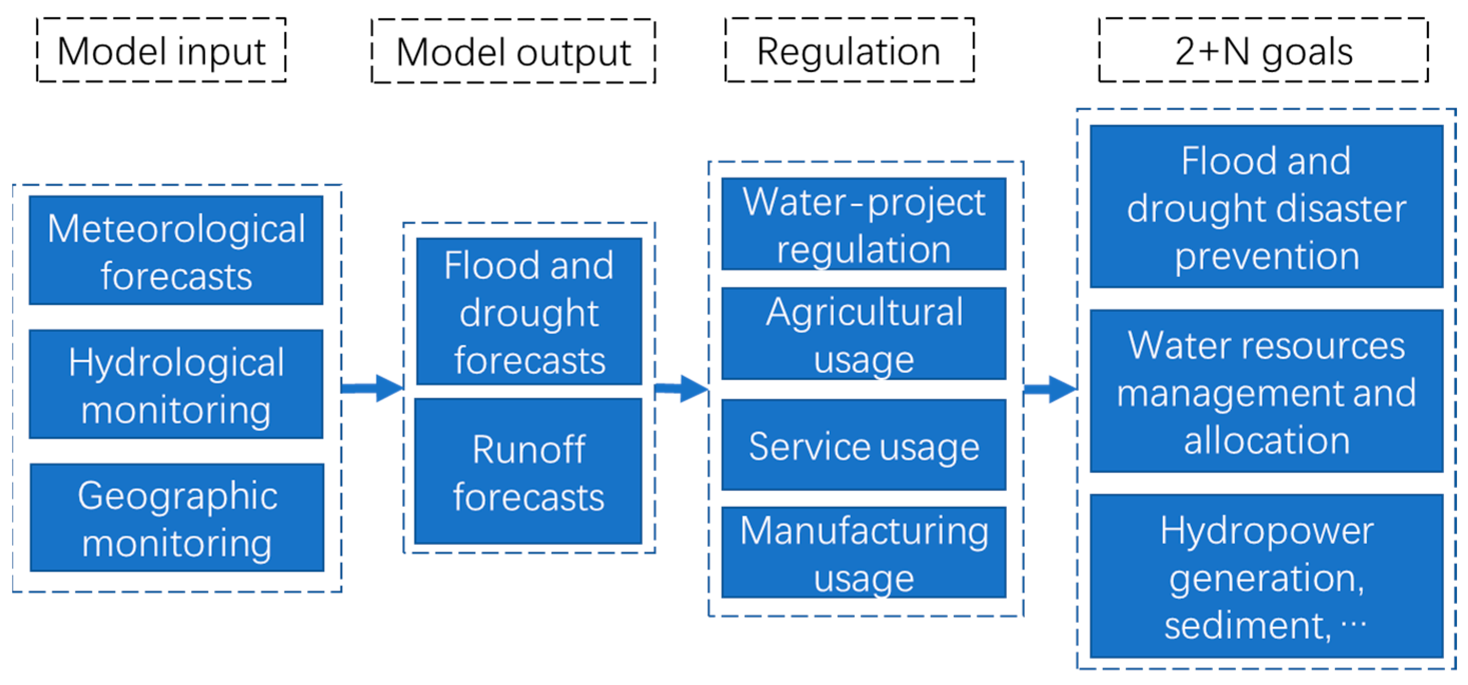
Despite increasing capabilities for understanding the relevant physical and social phenomena of water management and automating the numerical modeling of them, the process of promoting water project and watershed management (
Figure 1) has not advanced greatly in the last decades [
10,
11]. Model inputs for hydrological and hydraulic modeling are supplied by different groups using different methodologies and specialized models in different databases [
12]. Model inputs for selected cross-section prediction are pulled from different databases by a hydrological and hydraulic modeling group who then apply them to either conceptual or physical models to develop model outputs for cross sections or regions of interest. These model outputs are placed in a new database. Water project regulation and water usage experts use these outputs to develop a feasible, economical regulation plan either relating water disasters to prevention measures such as a reservoir release plan or relating water demand and water supply such as a sluice and/or pump operation plan. A regulation plan is applied to real-time water project and watershed management at each cross section or region of interest to satisfy several goals, including flood and drought disaster prevention, water resources management and allocation, hydropower generation, and so on.
Increased computational horsepower has enabled each of the individual parts of this process to be performed more efficiently. Therefore, more model inputs and water usage resulting from a larger population and faster development in China [
12] can be analyzed effectively. The output files from one model are more readily transferred into input files for the next step of the water management process.
As an innovative technology, a digital twin scheme relies on the integration of virtual network models, optimization algorithms, real-time data collection, and smart actuators with Geographic Information Systems (GIS) data [
3]. However, there has been little effort made to integrate the physical and social phenomena in these individual models into a single comprehensive representation for water project and watershed management under the digital twin scheme. Nor has the dependability in the models of the physical and social phenomena increased significantly. The hydrological and hydraulic modeling for water project and watershed management are essentially the same ones that were used when calculations were performed on handheld calculators instead of tools like Microsoft Office Excel, which are incapable of considering all model inputs (
Figure 1). As a result, the identification of the locations of flood and drought disasters and water-deficient areas relies primarily on engineers’ subjective judgement and historical lessons. Because of judgment born of experience, existing water project and watershed management is fairly successful; however, under the fierce influence of climate change, population explosion, fast urbanization, and the deficiency of integrated water management [
13], water project and watershed management is fraught with unexpected problems [
12] like duplicated facilities, inefficient cooperation, and so on.
Water project and watershed management (
Figure 1) was the best that could be accomplished in the years before digital computing became commonplace. The management process was used to design engineering measures to prevent flood and drought disasters, meet water demand, and establish feasible non-engineering measures to promote management efficiency. The coming of the computer age led to the automation of various parts of the traditional water project and watershed management. However, the entire management system has not been reexamined to see how the entire process can be reengineered as a result of the availability of high-performance computing.
When it comes to China, climate change, economic development, and population growth have made the water issue much more pressing than in any other regions in the world [
12]. Ever since 2017, the Ministry of Water Resources (MWR) in China has issued several official documents to promote the development of reengineering the water project and watershed management process under a digital twin scheme, hereafter called the Digital Twin Water Project (DTWP) and the Digital Twin Watershed (DTW).
In other regions, the need for reengineering water project and watershed management is much lower either because of lower population density in developed countries or insufficient financial capacities in undeveloped countries. In contrast, China has a strong desire to implement reengineering due to its large population, which is susceptible to the climate, and quick urbanization [
12].
However, there has been little research on the DTWP and DTW in China ever since reengineering was first initiated in early 2022. Here, we will review their legislation, evaluate the implementation of pilot projects, and investigate technical and administrative obstacles from the perspectives of design, policy, technology, investment, personnel, cyberspace security, co-construction, and sharing. Our data sources include 11 pilot DTWP embodiment reports and 7 pilot DTW embodiment reports examined and approved by the Ministry of Water Resources in China in early 2022.
Moreover, there is no research on the reliability of the design and implementation of DTWP and DTW in China. Bayesian networks showed great capability for flexibly representing and reasoning with probabilistic information [
14]. In order to identify the weak nodes of the DTWP and DTW, it was reasonable to choose a Bayesian network for this reliability analysis [
15].
This paper is organized as follows:
Section 2 investigates the national legislation of DTWP and DTW systems in China.
Section 3 describes the research area and how this case study was designed.
Section 4 presents findings from pilot projects and reliability analysis by Bayesian networks on anonymous projects. Lastly,
Section 5 concludes the paper, summarizing the results and providing suggestions for further work.
2. DTWP and DTW in China
Since 2017, the MWR in China has tried to reengineer water projects and watershed management under a digital twin scheme through national regulations, technical guides, national and water trade standards, and pilot projects.
2.1. National Legislation
A report to the 19th National Congress of The Communist Party of China on 18 October 2017 emphasized the implementation “of a data strategy to build its cyberspace strength, make itself a digital country and a smart society, and boost its economic transfer from rapid growth to high-quality development”. As an important component of a smart society, water governance is expected to take a data-based approach not only to create higher-level interactions with the public but also to enhance the ability of the government to respond to exigencies and solve problems with the aid of smart data technologies.
Afterwards, the MWR initiated a compilation of the
Implementation Plan of Intelligent Water Conservancy in China and
Demand Analysis for Water Conservancy in China and issued them in the Water Information File (WIF) 219 and WIF 220 in 2019 [
16]. Moreover, the MWR issued the
Three-year 2019–2021 action plan for improving its facilities of cyberspace and digitalization by WIF 171 in 2019 [
17]. The MWR issued the
Guide for promoting smart water conservancy construction, Top design of smart water conservancy construction, and
the 14th Five-Year Plan for smart water conservancy construction by WIF 323 in 2021 [
18], where the goal of smart water conservancy was to construct DTWP and DTW systems. On 21 February 2022, the MWR issued 126 pilot DTWP or DTW projects to gain experience that would be replicable and scalable.
The MWR issued the
Regulation on joint construction and sharing of digital twin watershed (to try out) by WIF 146 in March 2022 [
19], which articulately stated in Article 3 that a DTWP is an important part of a DTW. A DTW is composed of a digital twin platform and information infrastructure (
Table 1). A digital twin platform includes a data backplane, model platform, and knowledge platform, whereas an information infrastructure includes a water sensor network, water information network, and water cloud.
There are regulations and guides on co-construction and sharing inside the MWR, watershed commissions, provincial water departments, and large water projects, mainly on the geospatial data of the data backplane, model platform, and knowledge platform. The data backplane includes basic data, monitoring data, operation management data, cross-industry sharing data, and geospatial data. Basic data refers to objects’ names, location, fundamental characteristic vales, where objects include rivers, watersheds, monitoring stations, management units, and so on. As defined by WIF 146 in March 2022, geospatial data is classified into Level 1 (L1), Level 2 (L2), and Level 3 (L3) based on the grid size of the digital elevation model (DEM), the resolution of the digital orthophoto map (DOM) and oblique photography, and their refresh rate (
Table 2). As defined by WIF 146 in March 2022, the MWR is responsible for building the national L1 geospatial data; watershed commissions are to build trans-provincial rivers’ L2 geospatial data; provincial water departments are to build inter-provincial rivers’ geospatial data; large water project owners are to build L2 and L3 geospatial data in relevant regions.
The model platform is made up of a hydrological and hydraulic model, intelligent model, and visualization model. The MWR is responsible for formulating universal models on hydrology, water resources, ecohydrology, hydraulics, sediment dynamics, water and soil conservation, engineering safety, intelligent recognition, and visualization. The water commission, provincial water department, and large water project owners are to separately develop unique models.
The knowledge platform is composed of a water knowledge map, historical scenario, operation code, and other expertise. The MWR is responsible for building universal knowledge on water projects, a forecast-regulation scheme, business rules, historical scenarios, and expert experience. Water commission, provincial water department, and large water project owners are to separately develop their unique knowledge.
In summary, the national legislation procedure for the DTWP and DTW construction follows a top-down processing style. The Report to The 19th National Congress of The Communist Party of China set a general goal regarding DTWPs and DTWs as part of a smart society. Then, the standardization administration (SA) and MWR in China issued national and trade standards to seek unity of action.
2.2. Technical Guide
The MWR issued the
Technical outline for digital twin watershed construction by WIF 147 in March 2022, which emphasizes the role of a DTW through a forecasting, warning, rehearsal, and plan methodology (FWRPM,
Figure 2) for “2+N” applications (
Table 1), including watershed flood control, water resource management and allocation, and other “N” applications. WIF 147 depicts the content of each component of the DTW and responsible units.
Many advanced technologies would be applied more widely and deeply for the DTW and DTWP. In the information infrastructure (
Table 1), a water sensor network emphasizes the application of a satellite, UAV, ground station network, and video. In the data backplane (
Table 1), there is high resolution satellite remote sensing, local mapping satellite, UAV remote sensing, Building Information Modeling (BIM), UAV oblique photography, and so on. In the model platform (
Table 1), there is a water conservancy model, visualization model, intelligent model, and digital simulation engine. The water conservancy model covers the fields of hydrology, hydraulics, sediment dynamics, water resources, soil conservation, water environment, and engineering safety evaluation. The visualization model provides scenes through nature of light and vegetation, flow of water and sediment, hydraulic projects, and electromechanical equipment. The intelligent model includes intelligent algorithms for speech recognition, image and video recognition, remote sensing recognition, natural language processing, and learning algorithms for classification, regression, recommendation, and retrieval. In the knowledge platform (
Table 1), there is knowledge representation, machine reasoning and machine learning for knowledge graphs, historical scenarios, business rules, and expert experience.
Moreover, the MWR issued the
Basic technical requirements for the forecasting, warning, rehearsal, and plan process for different applications by WIF 149 in March 2022, which depicts the general features of different applications under FWRPM (
Figure 2). Only the watershed flood control application is described in detail: (1) As a hydrological forecast is made, early warning information can be sent out to flood control staff or to the public by text, phone, fax, and so on. (2) As a real-time alarm or early warning occurs, like water release or slope slide and collapse, a consequent forecast would be made for further steps. (3) Based on hydrological forecasts, a water project operation and an emergent scheduling plan would be rehearsed for different scenarios, which is summarized as
Rehearsal. A forecast can also be part of the rehearsal. (4) In some cases, special warning information can ignite the rehearsal. (5) After rehearsal, the best plan for the water project operation and emergent scheduling would be chosen. (6) As the plan is being carried out, disaster or inappropriate water project operation and emergent scheduling plans may trigger the rehearsal. (7) As the plan is being carried out, some warning information would be sent out.
The MWR issued the
Technical guideline for digital twin water project construction by WIF 148 in March 2022, which describes technical requirements from the perspectives of the digital twin platform, information infrastructure, and typical water application (
Table 1). For a DTWP, intelligent analysis and warnings for engineering safety are considered the most important applications among all.
In summary, although the MWR intensively issued files on regulations, technical outlines, and requirements for DTWP and DTW in March 2022, these files are either sketchy or insufficient. For example, WIF 149 mainly concentrates on the application of flood control, which is not good for other applications like water resource management and allocation and intelligent analysis and warnings for engineering safety.
2.3. National and Water Trade Standards
During 2017–2021, national standards and water trade standards had been continuously issued to guide the construction of DTWP and DTW systems in China. The standardization administration (SA) of China had issued national standards for cybersecurity and digital aerial photography, including
Information security technology—Technical requirements of security design for classified protection of cybersecurity (GB/T 25070-2019) [
20],
Information security technology—Implementation guide for classified protection of cybersecurity (GB/T 25058-2019) [
21],
Information security technology—Classification guide for classified protection of cybersecurity (GB/T 22240-2020) [
22],
Information security technology—Baseline for classified protection of cybersecurity (GB/T 22239-2019) [
23],
Technical specifications for oblique digital aerial photography (GB/T 39610-2020) [
24], and
Specifications for low-altitude digital aerial photography and data processing (GB/T 39612-2020) [
25].
The MWR issued water trade standards including the
Technical specification for the appraisal of a dam safety monitoring system (SL/T 766-2018) [
26],
Protocol for water data exchange (SL/T 783-2019) [
27],
Specification of the operation and management of safely monitoring the water system and hydropower projects (SL/T 782-2019) [
28],
Protocol for a water spatial data exchange (SL/T 797-2020) [
29],
Specification for a water data catalogue service (SL/T 799-2020) [
30],
Specification for a water spatial information service (SL/T 801-2020) [
31],
Technical specification for the cybersecurity of water resources (SL/T 803-2020) [
32],
Guideline for telecommunication services for a water sector (SL/T 292-2020) [
33],
Structure and identifier of a database for the basic information of a water object (SL/T 809-2021) [
34],
Data transmission protocols for water conservancy monitoring (SL/T 812-2021) [
35].
In summary, so far, the national and water trade standards have mainly focused on cybersecurity, digital aerial photography, and data processing, which are insufficient to guide the comprehensive construction of DTWPs and DTWs. This is the reason why the MWR initiated 126 pilot projects with the goal of obtaining more replicable and scalable standards in the future.
2.4. Status in 2021, Goal in 2025, and Expectation in 2035
While the 2019–2021 plan for cyberspace and digitalization by WIF 171 in 2019 mainly focused on cybersecurity, water sensor networks, water information networks, data sharing, water management applications, and water public service products, Regulations on DTWP and DTW (like WIF 323 in 2021, and so on) for the 14th Five-Year Plan (2021–2025) revealed specific goals for 2025 and expectations for 2035.
First, regarding cybersecurity, the rate of meeting the required protection standards for key information infrastructures of the MWR, watershed commissions, and provincial water departments reached 100% by 2021, and the rate of meeting the required protection standards of information systems above the third level reached 90%. In 2025, cybersecurity for key information infrastructures will extend to prefectural, county water departments, and their technical support organizations.
Second, the water sensor network was improved mainly through hydrological stations, high resolution satellite remote sensing, and water video control platforms. More than 30% of all hydrological stations enacted automatic monitoring. In 2025, automatic monitoring will cover 95% of important rivers’, lakes’, and reservoirs’ hydrologic stations; 95% of reservoirs’ precipitation stations; and 90% of dam safety monitoring for large–middle-sized reservoirs. High resolution satellite remote sensing images covering the entire country will be updated four times a year. In 2025, new technologies like Internet of Things (IoT), unmanned aerial vehicles (UAVs), and remote sensing will be applied much more. Previously, the connection between water video control platforms was established between watershed ones and provincial ones. In 2025, the rate of connection among the MWR video platform and watershed commissions and provincial video platforms will reach 95%.
Third, communication of water emergency events was significantly improved. The water information network and high-definition video conference system among provincial water departments and the MWR and their main technical supporting organizations were fully connected. By 2025, this connection will have been extended to prefectural county water departments and their technical support organizations. Presently, the national backbone network bandwidth reaches 100 Mbps, the network bandwidth among watershed commissions and provincial water departments reaches 50 Mbps, and the local network bandwidth reaches 30 Mbps. By 2025, the Internet Protocol Version 6 (IPv6) will have been fully established for all water departments and other technical supporting organizations.
Fourth, data sharing was improved through the construction of the MWR node, watershed commission nodes, and provincial water-department nodes, and through the conjunction among the water industry and outside industries. All water-related data was depicted in one single water map (SWM) and comprehensively and consistently analyzed, processed, mined, and applied. In 2025, big data centers for water in the ministerial, watershed, and provincial water departments will be constructed for real-time data analysis and mining, such as monthly data processing from remote satellite sensing data.
Fifth, new technologies such as artificial intelligence were applied in 2021, and smart water management platforms were built. The main water management applications (including water resources management, water ecology, water environment, water disaster, and so on) above the provincial level had basically been realized by process optimization, operation collaboration, and intelligent applications in some fields, like identification of illegal encroachment by remote sensing images. In 2025, the main water management applications shall be carried out for all water departments.
Sixth, water departments accomplished online water administration. And public services were created and promoted through Single Water Map (Public version), Water Search, and Water Media Convergence. In 2025, nationwide flood forecasting and risk warning products to deliver early warning information through a city public service system will be provided. Moreover, a national integrated water-related experience center to sponsor online and offline water science outreach will be built.
3. Data and Methodologies
3.1. Research Design
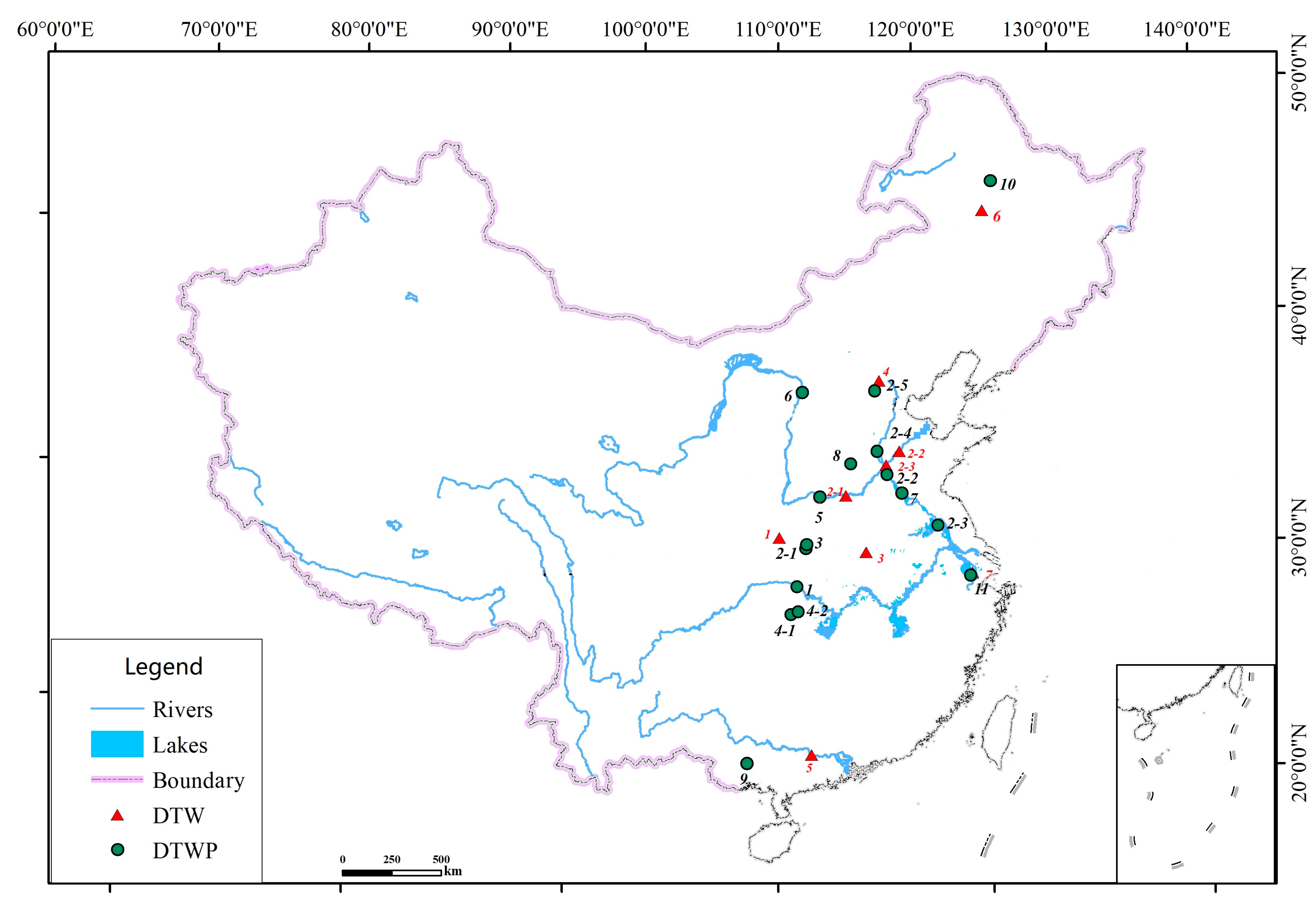
On 21 February 2022, the Ministry of Water Resources (MWR) in China issued 126 pilot Digital Twin Water Project (DTWP) and Digital Twin Watershed (DTW) projects to gain replicable and scalable experience, in which 7 DTW and 11 DTWP embodiments (
Table 3 and
Table 4, and
Figure 3) were approved by the MWR in June 2022 after examination on 21 May 2022. The 11 DTWPs are all first-class water projects supervised by the MWR or corresponding watershed commissions in China, and they can work as a good sample for water management applications at the level of the MWR and watershed commissions. Out of these, 8 DTWPs are hydroelectric stations, while 3 DTWPs are pumping stations, sluice, and convey canals, which represent all kinds of nationwide water projects. In this way, these pilot DTWPs can provide reasonable experience for water managers.
The seven watershed commissions (
Table 3) were subordinate organizations of the MWR who chose their own pilot DTW projects, reflecting their distinguishing features. Only two watersheds were chosen for DTW projects, while the others covered the reach of larger rivers. The Taipuhe of the Taihu Watershed is an artificial canal, and the others are natural rivers with artificial dams, pumping stations, and sluices.
In order to obtain the latest understanding on DTWs and DTWPs, on 20 June 2022, our team initiated a study plan to run from June to August 2022 to assess 7 DTW and 11 DTWP pilot embodiments with the review of 10 experts and carry out field interviews in one watershed commission of each of the 7 pilot DTWs and in four companies owning the 11 pilot DTWPs. Six official experts coming from national research institutes and universities were invited for the review, and these were the same ones who joined the evaluation of the 7 DTW and 11 DTWP pilot embodiments for the MWR of China. The other four experts came from provincial water departments, having over 10 years of experience on water information technologies. Both the expert reviews and field interviews individually focused on the implementation of reengineering projects from the perspectives of design, policy, technology, investment, personnel, cyberspace security, co-construction, and sharing. The review reports and field interview results would be summarized and synthesized.
Based on these expert reviews and interviews, we investigated the design of DTWs and DTWPs and found exciting deficiencies. We provide suggestions for improvement from the perspectives of design, policy, technology, investment, personnel, cyberspace security, co-construction, sharing, and so on.
3.2. Bayesian Networks for Reliability Analysis
A Bayesian network is a directed acyclic graph where nodes (denoting random variables) are connected by arcs representing probabilistic dependencies. It is worth noting that the networks and nodes inside DTW and DTWP systems are all abstracted as nodes of a Bayesian network B = (N, E), where B is a directed acyclic graph. Notes N includes three kinds of nodes: model node M, data node D, and knowledge node K. Edges E represent conditional probability relationships among nodes.
The general Bayesian formulas are as follows:
where
P(
B) is the prior probability;
P(
A|
B) is the posterior probability;
P(
B|
A) is the likelihood probability.
Suppose A is a variable, having
a1,
a2, …,
an; thus, the total probability is
In order to illustrate how a Bayesian network can be applied, only data, model, and knowledge are considered here. First, we assumed that the data nodes had no parental nodes and were independent of each other. We also needed to acquire the prior distributions of each data node Prob(D), the conditional probability tables (CPT) for each model node Prob(M|D), and each knowledge node Prob(K|P,T). Second, it was assumed that there were only two states for each node, feasible 1 and infeasible 2. Prior distribution and CPT could be acquired from the statistics of records through a posteriori analysis. Third, with the assumptions of conditional independence, the Markov blanket worked, which meant that a node was only related to its parents and its children and its children’s parents.
For simple analysis, as we tried to examine the reliability of the simple system (including data, model, and knowledge) for the design and implementation of DTW and DTWP projects, it was easy to obtain the Bayesian network 1 (
Figure 4).
represents the Data, Model, and Knowledge. Their conditional relationships were described (
Figure 4), which generally reflected the real situation. Only if the data could satisfy the needs of the model could the modeling work. Furthermore, only if the modeling and knowledge were accurately obtained could the technique that was ultimately applied work.
By applying a Bucket Elimination algorithm, it was easy to obtain a reliability index.
If the infeasibility probability of was known, the reliability of DTW and DTWP projects could be derived.
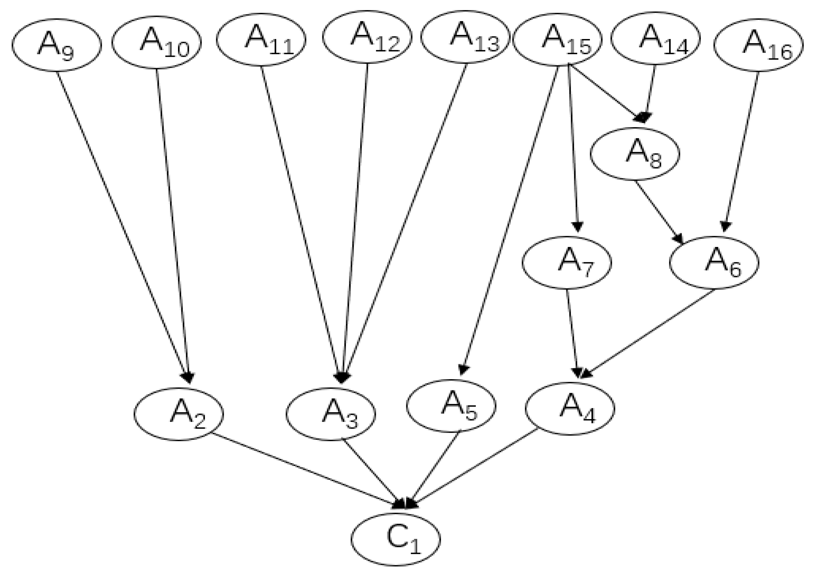
For complex analysis, since the DTW and DTWP projects consisted of not only software but also hardware, data, knowledge, and so on, it was common to categorize the projects into a complex Bayesian network (
Figure 5). Inside it, we had A9–A16 as the parental nodes, which could be different hardware for monitoring, computation, data transmission, and so on. A2–A8 could be software affiliated with some hardware, or modeling results based on data, or decisions made, and so on. Similar to Bayesian network 1 for simple analysis, a calculation for Bayesian network 2 was conducted.
4. Findings and Discussion
4.1. The Reasonable Design of DTW and DTWP
Under the influence of the population explosion, climate change, and fast urbanization, water management in China has a unique spatiotemporal diversity resulting from natural precipitation, runoff affected by urbanization, water supply facilities, water demand, water managers, water users, and so on. In other words, it is necessary to provide customized water applications through flexible processes in high volumes and at reasonably low costs. Consequently, with advanced information technology, water projects and watershed management in China is being reengineered under the digital twin scheme, which generates DTWs and DTWPs. In order to provide a DTW and DTWP of universal significance, notions of system architecture and business management were adopted based on 10 experts’ reviews.
Firstly, according to expert review, DTWs and DTWPs adopt the model of layered architecture [
36], the most popular and most widely used software architecture from computer science, which consists of a Presentation Layer, Business Layer and Data Access Layer. In order to overcome shortcomings like data dependency [
36], the MVC (model, view, and controller) can typically act as the Presentation Layer with the help of different design patterns [
37]. Correspondingly, a DTW and DTWP are composed of water application, a digital twin platform, and information infrastructure. Water applications work for interaction with water managers and users, and the digital twin platform works as the business layer, which connects the data downward and the application upward. Moreover, the information infrastructure works not only for data access but also for data transmission and data analysis.
Secondly, the DTW and DTWP also adopt the front, middle, and back office models taken from business management [
38]. Here, the front office represents water application focusing on interaction with terminal users, the digital twin platform represents the middle office, and the information infrastructure represents the back office, concentrating on data monitoring, storage, and processing. The goal of the middle office is to integrate general competencies to serve the front office, including model, data, and knowledge (
Table 1).
These are the main obstacles faced by the middle office when landing:
Go through interwoven departmental authorities and business ownership among different entities involved.
Invest in platform construction regardless of the cost.
Find a service provider with both qualified business and technical capabilities.
Prepare capable technical, business, and management staff correspondingly.
Guarantee data security after virtualization and cloudification.
Thirdly, inspired by the concept of mass customization, the DTW and DTWP are designed to provide individually designed water applications under the FWRPM (
Figure 2) to each water manager or user through high-process flexibility and integration that is based on flexible software developing and modern information technology. Consequently, a great number of water application varieties can be produced at the same cost. This business strategy, once considered a dream to be implemented for water management in the future, is progressively becoming reality for different water managers and users.
The success of DTW and DTWP systems depends on a series of external and internal factors as follows:
Water applications should be customizable. Successful DTW and DTWP systems must be modularized, versatile, and constantly renewed.
The demand for variety and customization in water application must exist.
The willingness and readiness of different governments and their water departments, water project managers, water users, and technical supporters to attend to the DTW and DTWP system must exist. Software developers, hydrological and hydraulic modelers, and other value chain entities must be part of an efficiently linked information network.
Technology must be available, especially hydrological and hydraulic modeling.
Knowledge and data must be shared. A DTW is a dynamic strategy and depends on the ability to translate new demands into new products and services.
The prerequisite of water customization includes accurate modeling and detailed data. Then, a cost–benefit analysis becomes the key to succeed or not, although water social services widely exist in a society. With accurate, timely, low-cost water services, water customization can work accordingly.
After investigating the design of DTWs and DTWPs in China, the review of 10 experts all confirm that the design is reasonable under these notions of system architecture and business management based on performance and cost–benefit analysis [
38,
39]. Moreover, it is necessary to conduct further studies on obstacles or factors determining their success or not.
4.2. Policy and Technology
The experts’ review and interviews conducted found that national legislation for DTWs and DTWPs was hasty for the MWR, watershed commissions, provincial water departments, and large water projects. And, generally, national legislation is followed by the local legislation of water management [
12]. However, at present, legislation is insufficient not only for provincial, prefectural, and county water departments to reflect their unique features but also for national legislation to reflect its ubiquitous features. For example, up until now, technical guides had mainly been issued for large water projects and watersheds, while national and water trade standards only focused on cybersecurity and spatial information services. Thus, the 7 DTW and 11 DTWP pilot projects during 2022–2023 are currently being implemented in order to obtain experience to guide legislation in the future.
While technology for information infrastructures, data backplanes, and model platforms (see
Section 2.2 Technical guide) are available, technology for knowledge platforms is not that complete and practical in theory. Although theory on knowledge management exists, there is little research on the integration between water management and knowledge management.
With regard to the information infrastructure and data backplane, while many advanced technologies will be applied more widely and deeply for DTWs and DTWPs, the national and water trade standards for applying these technologies must be designed and specified in advance. Data acquisition technology must have its unified standards. For example, as geospatial data is an important input for modeling, it is necessary to make appropriate arrangements of grid size and spatiotemporal resolutions of geospatial data on different areas of a watershed by considering modeling effects and economic efficiency. Consequently, the demand of modeling on geospatial data should be summarized as a national or water trade standard.
As for the model platform, the issue of modeling infeasibility, such as hydrological modeling, may exist. For example, present flood modeling technology cannot provide a long enough forecasting period and a high enough accuracy rate to support advanced countermeasures to minimize the effects of floods, droughts, and other water crises. Due to the long-time influence of run-off generation and confluence and long series of historical data [
12], the forecast period and accuracy rate in large water projects are generally better than in middle and small water projects like cross sections in mountain flood ditches. According to the MWR, in 2009, flood damage in middle and small rivers accounted for 70–80% of the total effects of flooding in China, which was maintained at almost the same rate until 2020. Thus, the forecast period and accuracy rate of modeling in middle and small rivers must be significantly improved to match the development need of DTWPs and DTWs, respectively.
4.3. Investment, Personnel, and Cyberspace Security
It was found that while investment for existing water projects mainly comes from their income or the government’s financial support, water projects under construction can make design changes to invest in the development of DTWs and DTWPs. For new ongoing water projects, although there is no technical guide in plaintext form that demands their construction, both water engineering design enterprises and technical approval enterprises in the water industry of China agree that investment in DTWs and DTWPs for a new water project should be considered as an inevitable part of total construction investment.
Investment in the 7 DTW projects comes from the seven watershed commissions of the MWR. In fact, the seven digital twin basins all asked for finance from the Ministry of Water Resources, which would be inconsistent. For example, the Songliao Water Resources Commission tried to apply for financial support from the Ministry of Finance, China through the MWR in October of 2022 for the Nierji-Sanchahekou reach of the Nenjiang River (the 6th DTW project in
Table 3).
By contrast, among the 11 DTWP projects, investment in 6 DTWP projects came from incomes from hydroelectric power generation, investment in 3 DTWP projects was provided by its watershed commission, and investment in 2 DTWP projects was supported by the projects’ design change under construction (
Table 5). Although there was construction investment for these pilot projects, it is necessary to establish finance mechanisms to provide subsequent and sustained costs of construction and operation and maintenance.
As for new water conservancy projects, there is a new chapter in their design reports, which aims to provide detailed design for DTWP and DTW constructions and provide financial support in the beginning of fund raising. In this case, the subsequent construction, operation, and maintenance costs would be guaranteed right in the design stage, which would be important for sustainable DTWP and DTW constructions.
Since DTWPs and DTWs are new to water managers, personnel with backgrounds in the information sciences are quite limited (
Table 5). For example, the Datengxia DTWP (
Table 1 and
Table 5) recruited professional personnel in early 2022. Thus, it was necessary to provide related training for these water managers and related practitioners lacking professional knowledge.
Cyberspace security, which has been greatly emphasized ever since 2012 in China, becomes more pressing due to Sino–American rivalry [
40]. Although hardware and software decoupling are ongoing, they have constituted a great threat to cyberspace security. Domestic software and hardware are more secure than those abroad. However, this will cause not only problems of technical feasibility but also increase in construction investment.
4.4. Co-Construction and Sharing
As mentioned in the report to The 19th National Congress of The Communist Party of China in October 18, 2017, water governance under the digital twin scheme in China is not only a reengineering process of water projects and watershed management inside water departments but also part of the smart society in China outside water departments. Co-construction and sharing are desperately required to acquire the best ratio of investment to output.
In concordance with the co-construction and sharing of geospatial data of the data backplane, model platform, and knowledge platform that was defined clearly by WIF 146 in March 2022, firstly, it is necessary for a water information network to have high network transmission speeds and to provide sufficient cybersecurity inside and outside water departments. Take geospatial data, for example. According to interviews, the total geospatial data for one single large water project can reach 2 Terabytes (TB), among which the L2 geospatial data required to be shared with the MWR, watershed commission, and provincial water department is over 1.8 TB. Consequently, the water information network among the MWR, watershed commission, and provincial water department for this single large water project should have the transmission speed of over 500 Mbps with a leased private line. And these data should be protected with network isolation.
Secondly, institutional construction should desperately be carried out for co-construction and sharing between the water department and other departments under one government. Take the Rehearsal of the FWRPM (
Figure 2), for example. Interviews show that the Rehearsal requires real-time and high-spatiotemporal-resolution data from the natural resources department, emergency management department, meteorological department, and so on, which is too difficult to obtain due to the lack of institutional construction at present. A flood forecast without good precipitation forecasts from the meteorological department cannot generate a good regulation plan for water projects. Without the risk points from the natural resources department regarding geological hazards, which are mainly caused by serious precipitation, flood influence can never be estimated accurately. Because of this, an institution for co-construction and sharing between the water department and other departments under one government should be established.
Thirdly, it is necessary to put forward national or water trade standards on geospatial data, model input and output, and knowledge. On one hand, admittedly, there are standards for geospatial data, but it is necessary to establish new standards for geospatial data based on cost–benefit analysis to balance the investment of geospatial data and the modeling effects of relevance, since geospatial data is one of the most important inputs for hydrological modeling, among other. On the other hand, the co-construction and sharing of model input and output and knowledge must be based on common standards for efficient interaction inside and outside water departments. Moreover, it is acknowledged that creating standards for knowledge is more difficult than for models because knowledge of water management is still a new research field.
4.5. Reliability Analysis on Anoymous Projects
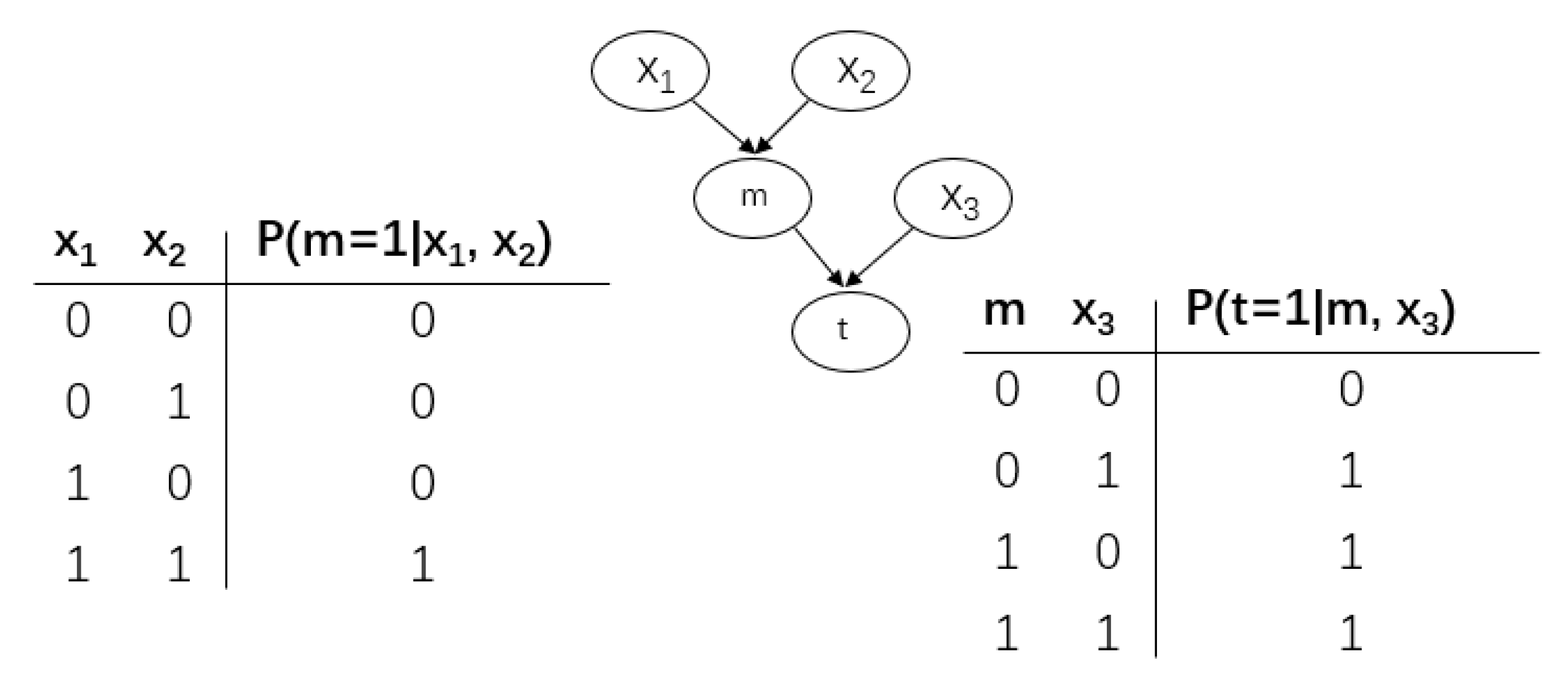
In order to concretely explain how reliability analysis is carried out in the design and implementation process of DTWs and DTWPs, a case study of an anonymous irrigation company in a county will be discussed. This is a real case study. Although it cannot reveal all the problems faced by the design and implementation of DTWs and DTWPs, it does cover the general process.
This is a reservoir DTWP (for anonymous reasons, named R project), whose main functions include irrigation, flood control, and water supply.
The infeasibility probability for is 0.04, 0.02, and 0.01, which means that Data, Model, and Knowledge might not meet the frequency and spatiotemporal criteria required.
By applying a Bucket Elimination algorithm, the reliability index (RI) for the whole DTWP is:
Supposing the whole DTWP is infeasible, the conditional probability of infeasibility for each component in () is 0.1115, 0.0926, and 0.926, respectively.
Moreover, we can infer the condition probability of nodes M and T if each component of the whole DTWP is infeasible (
Table 6). Take Data, for example. As Data becomes infeasible, the modeling M node would be infeasible at a 0.02 probability, and the whole DTWP would be infeasible at a 0.03 probability.
Consequently, although the infeasibility probability of Knowledge is the smallest, it can directly lead to the infeasibility of the whole DTWP, which means that Knowledge is the most important one among the three components. As the whole DTWP becomes infeasible, the conditional probability of Knowledge is the largest at 0.926.
Although the infeasibility probability of Data () is the largest, Data () and Model () constitute a parallel structure, which results in the fact that the conditional probability of Data is not the largest if the whole DTWP becomes infeasible.
In the R project, we have eight independent components in which two states exist: either feasible or infeasible. Each component’s infeasibility probability follows an exponential distribution; the failure rate (
) for A9–A16 components is 1, 1.5, 3.5, 2, 3, 10, 60, and 2.5 with the unit
.
is the reliability index;
t is the exposure time.
is the infeasibility probability. We calculated one year—365 days—with 24 h for each day.
The infeasibility probability of the whole DTWP in one year is 0.06.
Furthermore, for diagnostic reasoning, as the whole DTWP became infeasible, each component’s conditional probability (A9-A16) could be inferred, which were 0.015, 0.021, 0.051, 0.030, 0.041, 0.009, 0.848, and 0.003, respectively. As can be seen, because the in A15 was the largest, the conditional probability of A15 as the whole DTWP became infeasible was the largest—0.848, which is reasonable.
For causal inference, as each component became infeasible, each node obtained an infeasibility probability (
Table 7). As can be seen, different components played different roles on the reliability of the whole DTWP. It is feasible to locate the weak components to improve the reliability of the whole DTWP. And it is useful to apply a Bayesian network to provide insights into the design and implementation of DTWP and DTW projects.
5. Conclusions
It is a considerably large step to reengineer water projects and watershed management in China under the digital twin scheme into DTWs and DTWPs, which bears global potential for application in other regions. First, reengineering is a new field not only in China but also worldwide; it deserves and would benefit from the global attention of water researchers and water managers. The DTW and DTWP design is reasonable from the perspectives of system architecture and business management. Second, a Bayesian network for reliability analysis is a good tool for further assessment and improvement of reengineering. We are the first to put forward a Bayesian network reliability analysis method for the design and implementation of the DTW and DTWP.
Based on pilot projects of DTWs and DTWPs, there are three findings: (1) incomplete policy making and probable technical infeasibility; (2) insufficient mechanisms to sustainably support investment, personnel, and cyberspace security; (3) and co-construction and sharing required for both inside and outside water departments.
Admittedly, the DTW and DTWP are new to China, which requires water researchers and water managers to make more efforts in many relevant fields, such as modeling, policy making, and so on. In the future, we will study how to maximize the cost–benefit analysis for a DTW/DTWP project.


