Article

Geological Significance of the Perrot Spring in Mont Avic Natural Park (NW Alps)

by
Maria Gabriella Forno
,
Marco Gattiglio
,
Stefano Ghignone
*,
Domenico Antonio De Luca
and
Luis Miguel Santillan Quiroga
Earth Science Department, University of Turin, Via Valperga Caluso 35, 10125 Torino, Italy
*
Author to whom correspondence should be addressed.
Water 2023, 15(17), 3042; https://doi.org/10.3390/w15173042
Submission received: 21 July 2023 / Revised: 12 August 2023 / Accepted: 18 August 2023 / Published: 24 August 2023
(This article belongs to the Special Issue Fluvial Geomorphology, River Management and Restoration)

Abstract

:
Alpine areas shaped in a normally fissured bedrock do not typically contain important groundwater aquifers. In contrast, a wide Quaternary cover in mountainous areas, especially of landslide deposits, can make large aquifers promising for water withdrawals. A geological study of the central sector of the Chalamy Valley, a right tributary of the main Dora Baltea River (Aosta Valley) in which the Perrot Spring is located, was carried out, with the aim of providing a preliminary assessment of hydrogeological significance. The main interest of this investigation is, in addition to the high discharge of the Perrot Spring, its location within Mont Avic Natural Park, which is a very busy area with walkers, cyclists, visitors, and scholars. The geological survey shows a thick body of sandy silty glaciolacustrine sediments, consequent to the barrage of the Chalamy Valley from the glacier hosted in the main Aosta Valley. These sediments, outcropping in the north-facing slope of the Chalamy Valley, are involved in significant gullies and covered by a thick landslide accumulation located in the northern slope of the Bec de Nona, formed by very heterometric sediments. A wide detachment scarp is shaped in serpentinite characterized by evident fracture systems. The preliminary hydrogeological significance for the Perrot Spring, located at the boundary between glaciolacustrine and landslide sediments, was proposed. In detail, the thick landslide cover, characterized by high permeability, represents an important aquifer with a relatively fast groundwater flow to the spring. The underlying glaciolacustrine sediments of the low band of the slope, typically with very low permeability, favor the concentration of groundwater near the boundary with landslide sediments and the spring supply.

1. Introduction

The most remarkable hydrogeological aquifers are mainly contained in thick alluvial plains deposits. The numerous aquifers that characterize them have been extensively studied, while less attention has been given to hydrogeological aquifers found in mountainous areas [1]. The presence of aquifers and related emergencies at these sites are governed by several factors, including the distribution of sediments and their changes in porosity, the presence of impermeable levels, and the features and fracture state of the bedrock and its involvement in tectonic structures.
Indeed, major emergencies in the Alpine chain are influenced by these factors interacting with each other in various ways [2]. In detail, Alpine areas with normally fissured bedrock do not typically contain important groundwater aquifers [3,4]. In contrast, mountainous areas with highly fissured bedrock, such as those involved in deep-seated gravitational slope deformation (DSGSD) [5,6] or characterized by a wide Quaternary cover, can contain large aquifers [7,8]. In particular, the areas with large and thick landslide accumulations are promising for groundwater water withdrawals. Furthermore, knowledge of these aquifers is also useful to preserve the recharge zone of the mountain springs [9], which water has an important role for management, conservation, and restoration over time [10,11].
The aim of this work is to investigate the relationship between water emergence and setting of Quaternary deposits resting on a metamorphic bedrock with varying degrees of fracturing. The investigated area, located in the Aosta Valley, consists of the middle stretch of the Chalamy Valley, corresponding to a right tributary of the Dora Baltea River, which is characterized at the head by the very spectacular Mont Avic (3006 m) and the higher Mont Glacier (3185 m); this area also preserves a relict small glacier. This research was chosen based on the location of this area within the Mont Avic Natural Park, which is a very busy area due to walkers, cyclists, visitors, and scholars, as well as the presence of the high-discharge Perrot Spring at the bottom of an important landslide accumulation (Figure 1).
A multidisciplinary study of the middle sector of the Chalamy Valley was carried out for reconstructing the geological setting of the area in which the Perrot Spring is located. The study of this spring can supply a useful contribution to the investigations of springs with high discharge in the Alpine area.

2. Materials and Methods

A geological and geomorphological approach is used, allowing for a reconstruction of the geological and hydrogeological setting of the investigated area. In detail, a geological survey of the bedrock and Quaternary cover is made, allowing us to define the geometric relationships among different rock volumes and draw a new geological map. The map at a scale of 1:10,000 covers an area of approximately 6 km2 at an altitude between 850 and 2200 meters above sea level. The bedrock survey also identifies the attitude of the regional schistosity and structurally analyzes the fracture systems. The Quaternary investigation is carried out by studying the sedimentological features of sediments in combination with their morphological setting. Lithological and geomorphological data are stored in a GIS database using the UTM WGS84 reference system and all topographic elements (contour lines, hydrography, buildings, and roads) are derived from the map “Carta Tecnica Regionale Vettoriale” at a 1:10,000 scale for the Regione Autonoma Valle d’Aosta (Edition 2005–2008). The geological survey is performed at a 1:5000 scale and it is integrated with the use of a digital terrain model to better understand and report the distribution and shapes of Quaternary deposits in the geological map, as well as major structural discontinuities. Temperature and discharge measurements are carried out in the Perrot Spring.

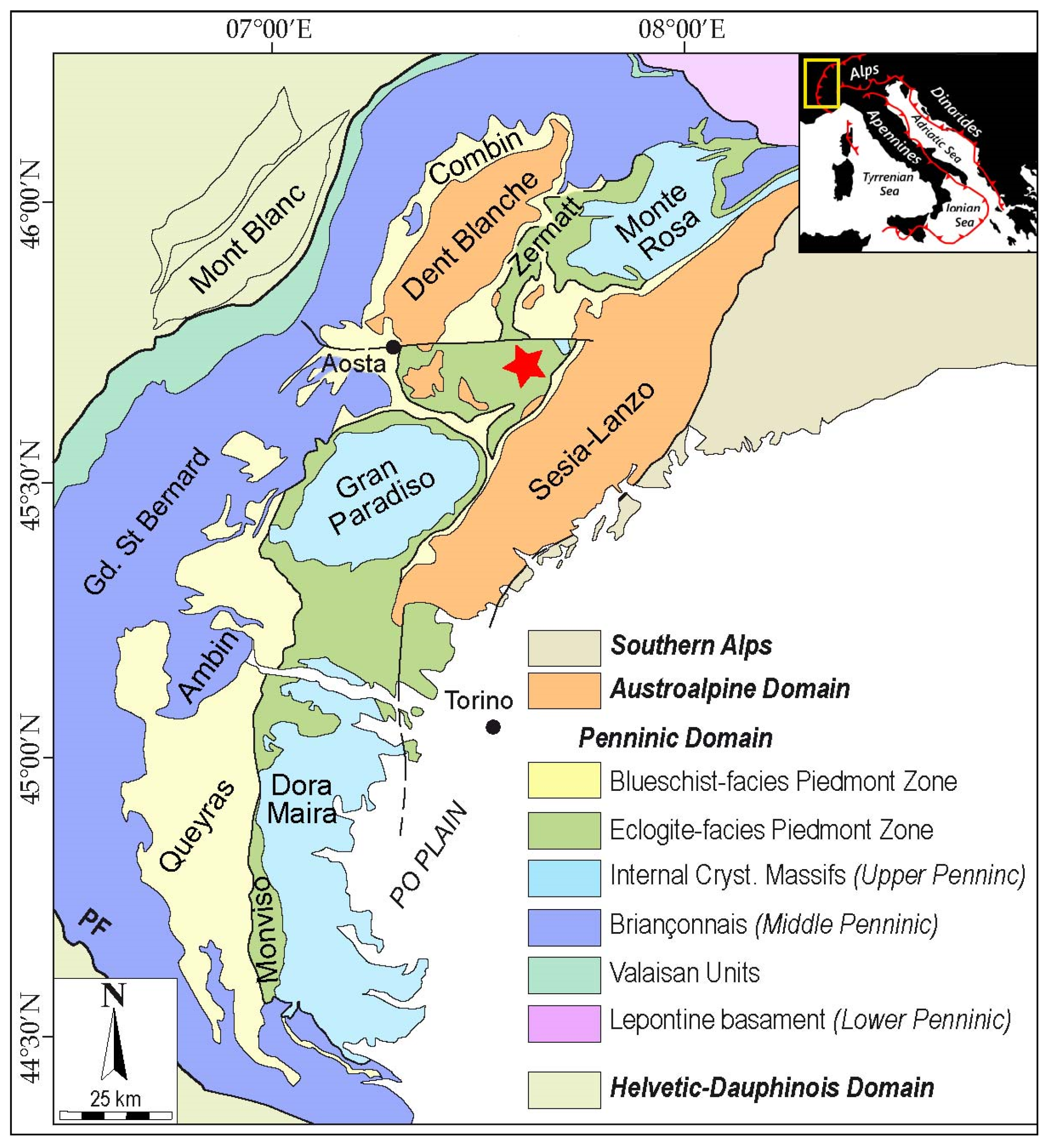
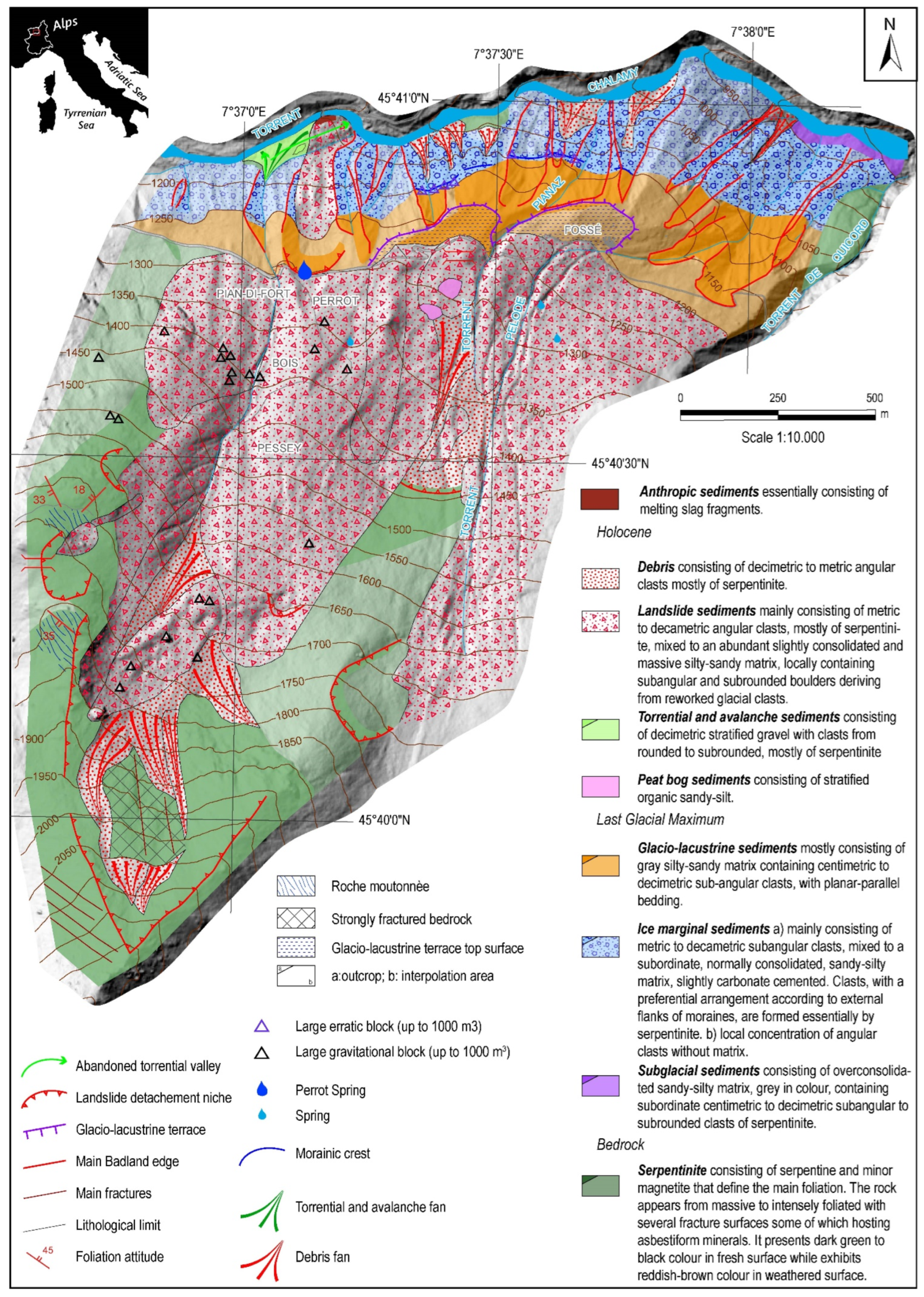
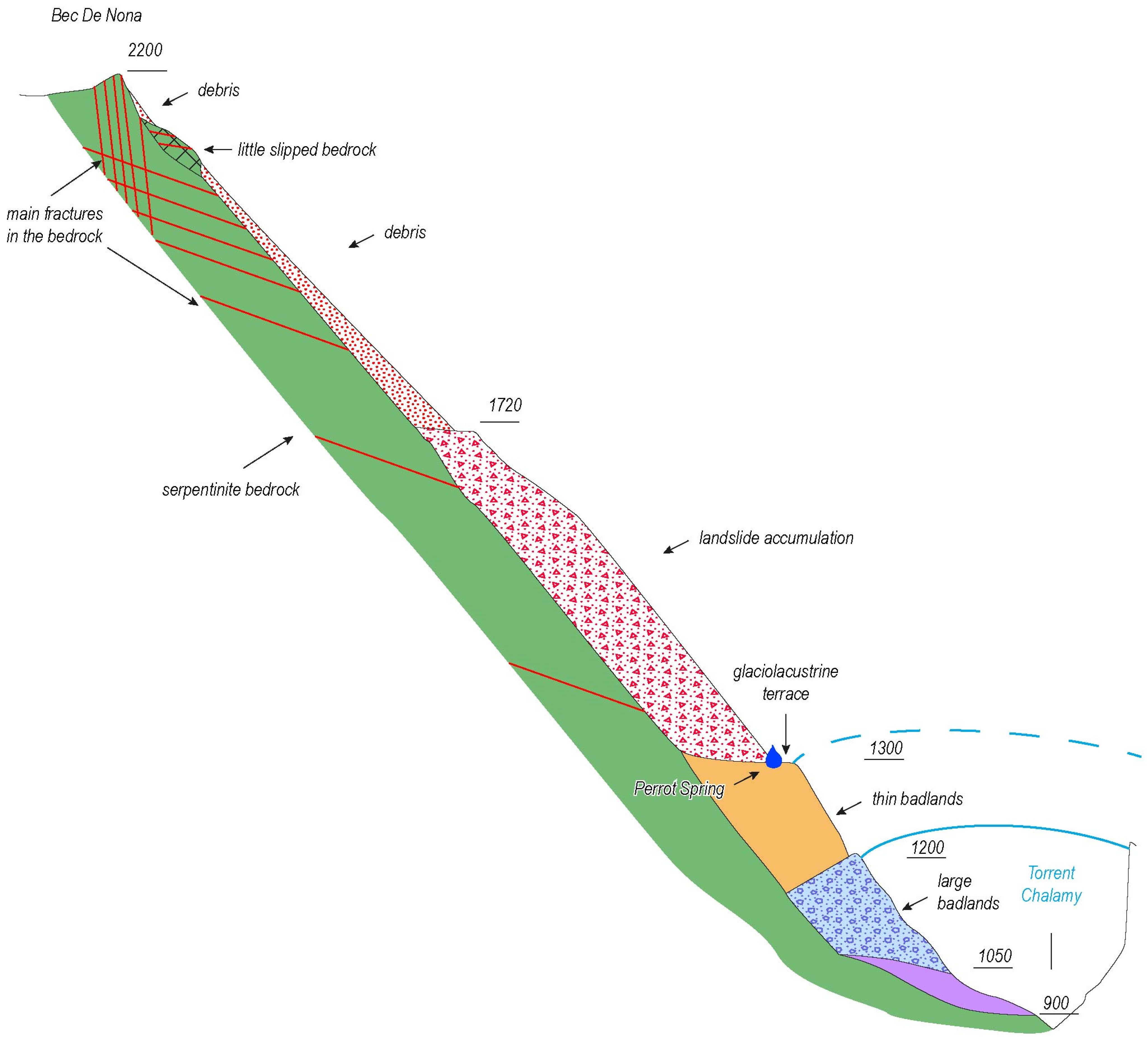
3. Geological Setting

Mont Avic Natural Park is included within the axial zone of the Alpine Chain and, in particular, consists of rocks that are part of the Penninic Domain (Figure 2). This domain consists of oceanic and continental-derived rocks related to the Ligurian-Piedmont Ocean and the European continental paleomargin, respectively.
The oceanic units of the Piedmont Zone consist of ophiolite and its sedimentary cover spanning the Jurassic to the Cretaceous. These units, at the mountain chain scale, are subdivided into eclogite facies units (Inner Piedmont Zone) and blue schist facies units (Outer Piedmont Zone) [13].
Most of the Mont Avic Natural Park area lies within the Inner Piedmont Zone, showing an extensive portion of original mantle comprising variously serpentinized peridotite, including hectometric bodies of Mg and Fe-Ti metagabbro, and is covered by discontinuous oceanic-bottom magmatic rocks and pelagic sedimentary successions [14,15,16].
The Alpine orogeny strongly reworked, both texturally and metamorphically, the rocks of the metamorphic bedrock. The primary rock textures were modified as a consequence of the development of metamorphic foliations related to various Alpine tectonometamorphic events. Additionally, Alpine metamorphism yielded new parageneses with significant changes in the primary mineralogical associations; the metamorphic evolution resulted in a peak in eclogitic facies and subsequent retrograde blue schist and green schist facies [17].
Alpine ductile deformation is characterized by four plicative events (D1 to D4), each of which developed under different metamorphic conditions [17]. The D1 event, which is rarely observed in serpentinite, is defined by S1 schistosity that is visible only in discrete millimetric volumes, where discontinuous S1 schistosity is enveloped by the subsequent S2 foliation. In these rocks, the D1 event is defined by clinopyroxene, olivine, Ti-clinohumite, magnetite, and antigorite mineral association. The D2 event resulted in the S2 metamorphic foliation and represents the regional schistosity of the investigated area. This foliation developed under epidote–amphibolite to the greenschist facies metamorphic conditions and is defined by antigorite, Ca-amphibolite, Ti-chlinohumite, chlorite, and magnetite association. S2 dips from SW to NW with 20° to 50° slope values. The D3 event deformed the regional S2 schistosity by producing a metric-scale chevron fold-like geometry whose axes dip to the NW and SW at medium to low inclinations without a new axial plane foliation. This event developed under postmetamorphic conditions without generating new metamorphic recrystallization. The D4 event is only locally recognizable, producing metric kink folds with a mean NE-SW axis trend. Also, this event did not result in axial plane foliation and metamorphic recrystallization.
The Mont Avic Natural Park area was largely shaped by glaciers during the Pleistocene last glacial expansion, the so-called Last Glacial Maximum (LGM), and during the retreat episodes, the so-called
Late Glacial [18]. These phenomena produced a morphology of the Chalamy Valley that is characterized by steep slopes, which are essentially shaped in the bedrock, and a wide valley floor, which is partially filled by a thick succession of various types of glacial deposits (Figure 3). Glacial phenomena have also caused glacial exaration over vast areas, responsible for the diffusion of “roche moutonnée” along the valley sides (Figure 4). The low sector of the glacial slopes is also discontinuously covered by gravitational and debris sediments.
The subsequent watercourses deeply incised the valley floor, shaping steep walls characterized by badlands, which are observable in a large stretch of the valley at the base of the right slope. The badlands are locally so close together that thin ridges are present between the different gully incisions, and they are covered by conifers. Several badlands are active, with gullies partly filled by unweathered recent debris, and others are nonactive, with gullies partly filled by weathered ancient debris.

4. Results of the Geological Survey
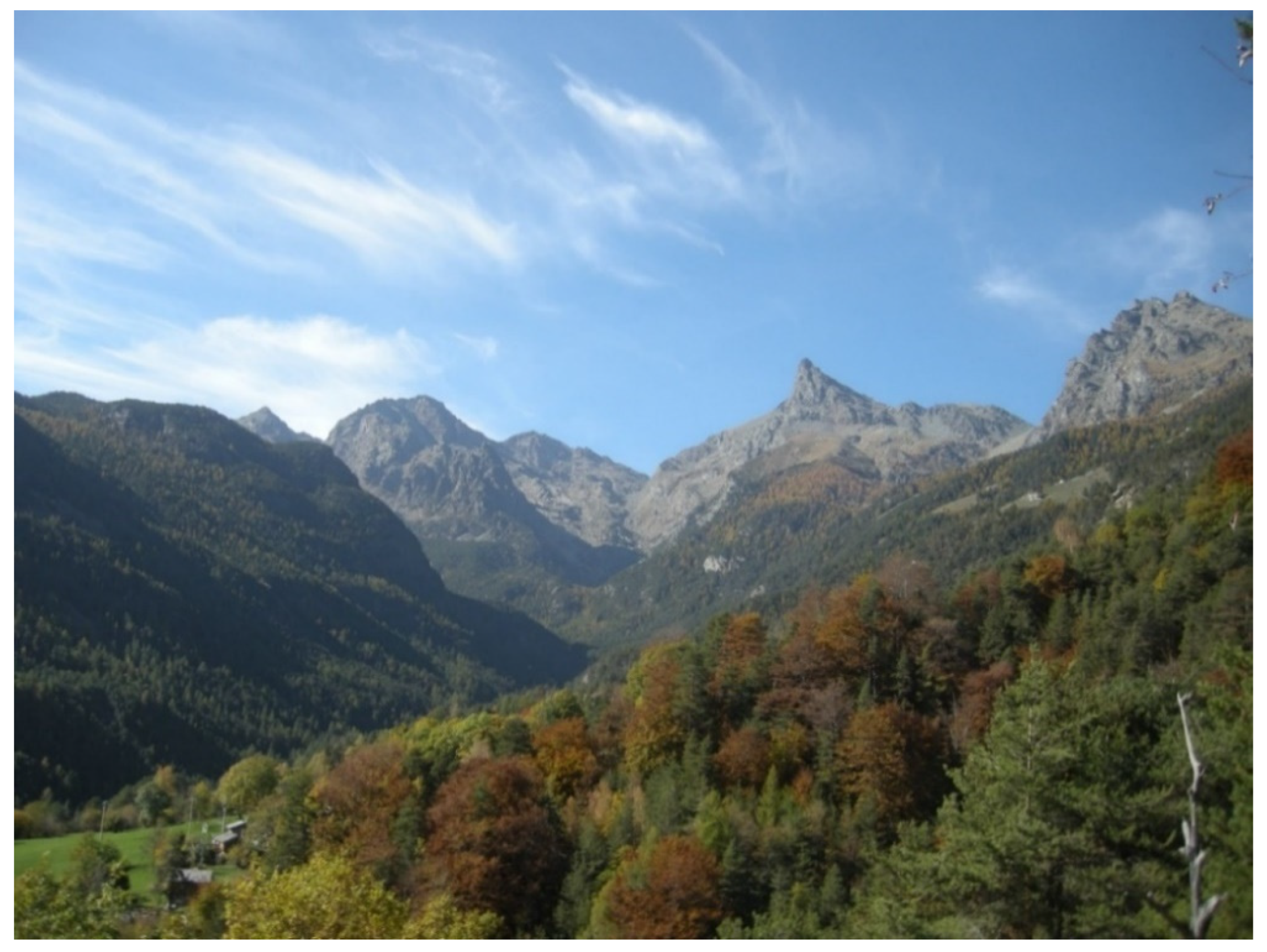
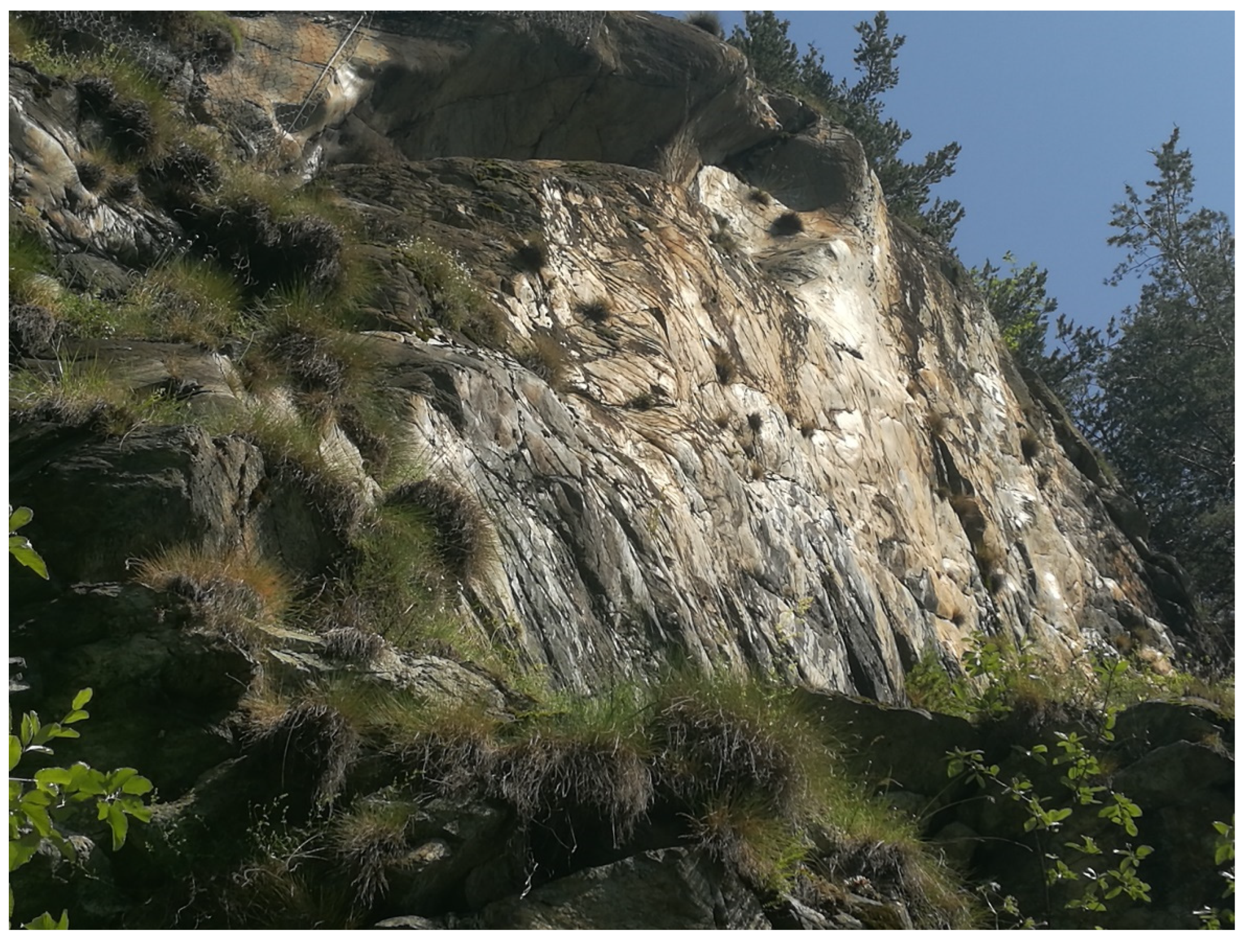
The detailed survey of the right slope of the middle Chalamy Valley (Figure 1) allows us to confirm the monotonous composition of bedrock and instead to reconstruct a complex sequence of overlapping Quaternary sediments. The bedrock diffusely forms the higher sector of the slope (Figure 5) and only locally crops out at lower altitudes, at the base of the Quaternary succession (Figure 5). The Quaternary glacial sequence, comprising various types of sediments, is particularly thick (up to 240 m) in the glacial valley floor, which is now deeply cut by the Chalamy River (Figure 5) and exposed by wide badlands.

4.1. Bedrock

The bedrock is represented in the entire investigated area by serpentinite cropping-out mainly along the highest-elevation northern slope of Bec de Nona. This rock consists ofantigorite, titanoclinohumite olivine, diopside, chlorite, and magnetite. This last mineral, with sizes up to pluricentimetric black crystals, sometimes very abundant, defines the main foliation. Titanclinohumite, olivine, and diopside are also clearly visible macroscopically. Locally, relicts of primary microstructural sites of the former peridotite are also recognized. The serpentinite has a massive to strongly schistose-laminated structure and varies in color from black to various shades of green. The regional foliation in serpentinite steadily dips towards the W at medium to low slope values. Serpentinite is locally involved in shear zones, where it takes on a milonitic texture, becoming serpentinoschist.
In the study area, the large Quaternary deposits limit the observation of postmetamorphic brittle structures. Only a few NW–SE trending fractures were detected in the surroundings of the Bec de Nona peak (Figure 6). However, outside the studied area, four fracture systems are well-known [17]. The most common fracture systems show E–W and NE–SW trends, and the others are N–S- and NW–SE-oriented, respectively.

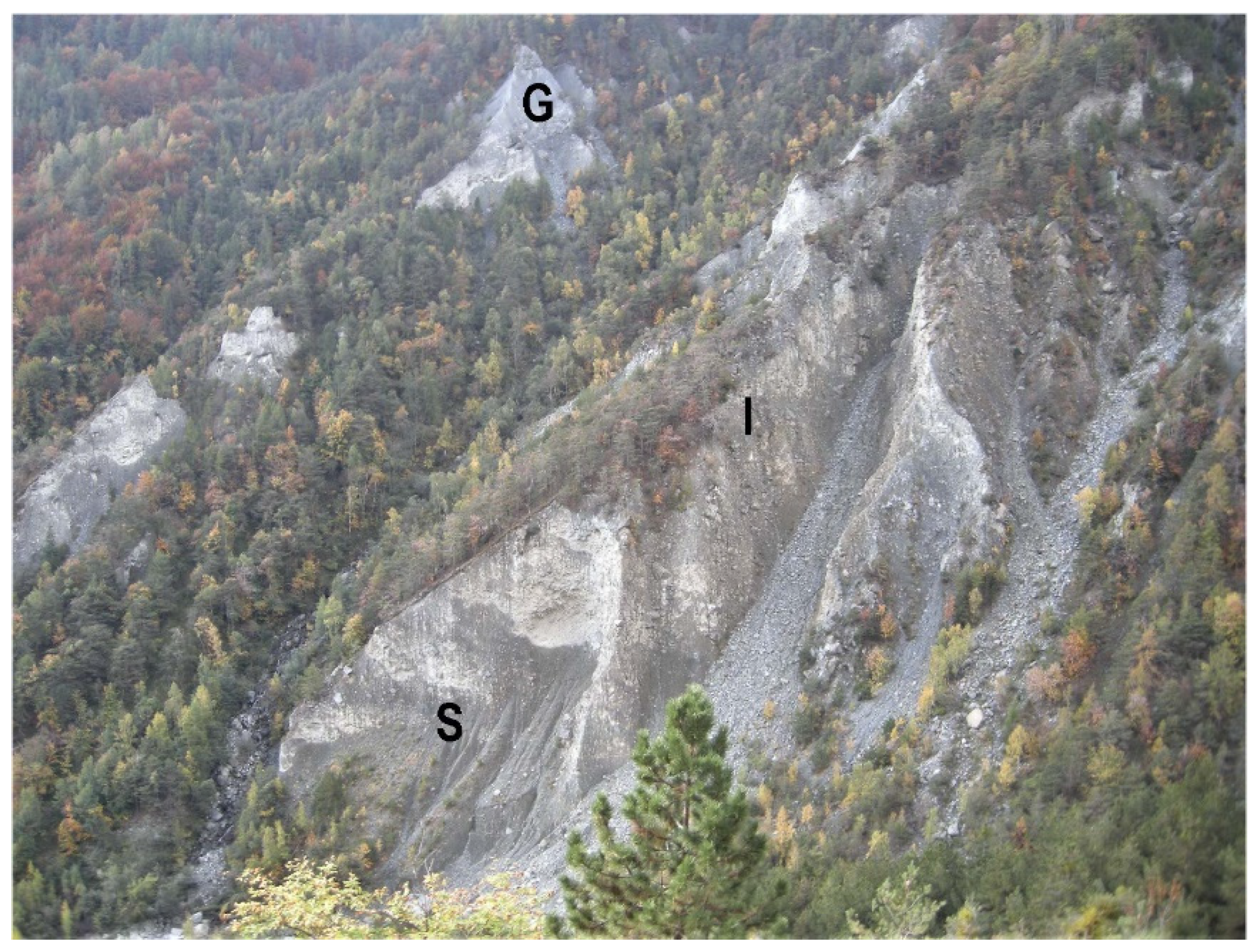
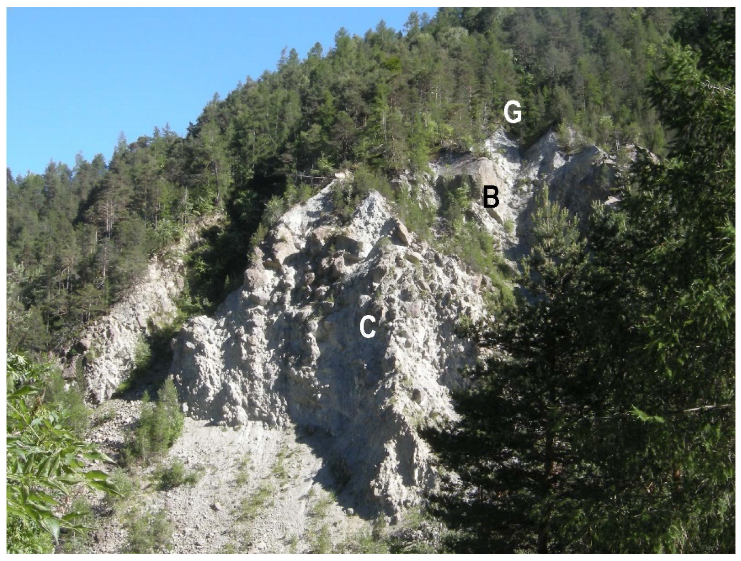
4.2. Quaternary Succession

The Quaternary glacial succession outcropping in the middle stretch of the Chalamy Valley floor consists of a thick sequence of subglacial, ice marginal, and glaciolacustrine sediments (Figure 6). This sequence, which partly filled the previous wide glacial valley floor, was subsequently exposed by deep incisions by watercourses, particularly by the Chalamy Torrent.
The steep walls connected to this incision, which are associated with the partly silty sedimentary facies, created favorable conditions for the formation of articulated and spectacular badlands, which allow the recognition of the different sedimentary facies of sediments and their large thickness (Figure 5).
The badlands are completely located in the very thick Quaternary glacial sediments; the overall thickness is between 150 m and 350 m, which does not allow us to observe the bedrock (Figure 5). The badland features are variable according to the facies on which they develop. Badlands that involve coarse-grained ice marginal sediments show relatively wide ridges. Badlands formed on fine glaciolacustrine sediments are instead characterized by very thin ridges.
The subglacial deposits, which rest directly on the bedrock exarated by the glacier, extensively crop out in the lower band of the investigated slope, which partly exposes badlands with a visible thickness of approximately thirty meters (Figure 5). The subglacial sediments also form large gently sloping or flat areas characterized by extensive meadows used for livestock pasture, which are also outside the investigated area. The distribution of these sediments is particularly continuous in the lower-altitude band of the left slope of the Chalamy Valley between Servaz and Barbustel, as characterized by large grassy areas on which numerous mountain pastures are present and where the Park Visitor Centre is located (Figure 1).
These sediments, of uniform grey color, appear overconsolidated and formed by an abundant, fine, silty-sandy matrix, in which clasts of various sizes are embedded. The clasts, which mainly show sizes from a few centimeters to 1 m3 with faceted shapes, show a random arrangement or a hint of planar-parallel bedding with dips of 5–10° towards the NE (Figure 7). Their petrographic composition is monotonous, because the clasts are made up mainly of serpentinite, representing the locally outcropping bedrock, with more subordinate metagabbro and quartzite.
The ice marginal sediments, which generally rest on subglacial deposits with a sharp contact, also form the lower-altitude band of the investigated slope (Figure 5). These deposits, with an overall thickness varying from approximately 100 to 150 m, extensively crop out in wide badlands, forming the largest sedimentary body in the valley (Figure 7). They are also widely distributed on the left slope of the middle Chalamy Valley.
The ice marginal deposits are formed by clasts with very heterometric sizes, ranging from a few centimeters to over 1000 m3, and with various degrees of rounding (from subangular to more abundantly subrounded), mixed with a subordinate sandy-silty matrix. The petrographic composition of clasts is relatively monotonous, mainly formed by serpentinite with rare clasts of metagabbro, carbonate micaschist, prasinite, metabasite, and rodingite. These sediments show a yellowish grey color and a carbonate cementation that favors the preservation of high subvertical walls.
The ice marginal deposits form on the right side an elongated relief several meters high, parallel to the Chalamy Valley, which can be interpreted as the right lateral moraine, even if deeply dissected by the formation of extensive badlands. Another relief parallel to the Chalamy Valley is also preserved on the left side of the valley, corresponding to the left moraine.
The clasts show a prevalent arrangement towards the south on the right side (e.g., the outer slope of the moraine) and the top of the moraine is underlined by large boulders (Figure 8) that are oriented so that their long axes are directed along the glacier movement, as reported in other glacial valleys [19]. Concentrations of clasts almost without matrix are also locally present, simulating an outcrop of the bedrock (Figure 8).
The glaciolacustrine deposits are also widely distributed above the succession of subglacial and ice marginal deposits with large thicknesses up to approximately one hundred meters. These deposits show a sharp contact with the ice marginal sediments, with dips of approximately 10° towards the E. A subflat surface is present at the top of these sediments, forming a lacustrine terrace, gently dipping towards the E (i.e., downstream of the Chalamy Valley); this surface is largely preserved over large areas, although it is partly covered by landslide deposits.
The glaciolacustrine deposits show alternating fine- and coarse-grained bodies. The fine bodies consist of gravelly sand with subangular clasts, from centimeters to decimeters in size, and rare clasts up to 1 m3, mixed in a silty-clayey matrix. The coarse-grained bodies are instead formed by subangular clasts, from decimeters to meters in size, mixed in a poor matrix or without a matrix. These alternating sediments show planar-parallel bedding, with slight dips towards the SSE between 30° (for the lower layers) and 10° (for the top). The clasts mostly consist of serpentinite in both cases with rare metagabbro. The glaciolacustrine sediments show a carbonate cementation that favors the formation of steep walls of badlands, with dips between 45° and 75°.
The unweathered clasts and grey-colored matrix of the entire glacial sequence (subglacial, ice marginal, and glaciolacustrine deposits), associated with their location in the current valley floor, suggest a reference to the LGM, as also indicated for other glacial sediments in the surrounding area [18].
The landslide deposits are also widely distributed in the investigated slope, forming conical accumulations of various extensions, and they are laterally delimited by torrential incisions and characterized by a continuous cover of conifers (Figure 5). The larger landslide accumulation that can be observed at Bois Pessey, on the northern slope of Bec de Nona, is particularly significant; it is characterized by a convex landform, visible thickness of a few tens of meters (in the lateral incisions, the bedrock does not crop out), and surmounted by a large detachment niche in which the bedrock, made up of serpentinite, widely crops out (Figure 5 and Figure 6). The Bois Pessey landslide body, located in the altitude band between 1720 and 1250 m, rests on the terrace consisting of glaciolacustrine sediments that are widely buried in the western sector and only partially preserved. Other minor landslide accumulations partly cover the Bois Pessey body, from which they are separated by evident torrential incisions and are also identified in the eastern sector of the study area (Fossé sector).
The distal sector of the landslide accumulations is cut by torrential incisions, up to 15 m deep, in which the bedrock does not outcrop. Several large boulders of the landslide accumulations extend beyond their distal sector, directly covering the glaciolacustrine terrace (Figure 9).
The landslide sediments are very heterometric, formed by clasts with sizes between a few decimeters and several meters and associated elements of very large size exceeding a thousand cubic meters, mixed in a poor sandy-silty matrix. The clasts, which are essentially constituted by serpentinite, have shapes from subrounded to subangular. Concentrations of large blocks, up to 1000 m3, also occur in the distal sector of accumulations.
The main landslide niche shows a triangular shape in the Bec de Nona northern slope, comprising two significant opposite scarps (E- and NW-facing, respectively), and the higher sector of the crown is located at 2200 m. This niche is in serpentinite and shows E-W and NE-SW fractures. Wide sectors of the niche are covered by debris or other small landslide fans. A body of very fractured serpentinite, which shows little slip, is also locally preserved in the high sector of the landslide niche.
The other landslide niches, feeding the minor landslides, are located on the continuation of the two ridges forming the main investigated niche and they show a trend from N-S to NW-SE and NE-SW, respectively.
Several saddles with a main E-W trend are also recognized in the niche area, representing the evidence of the main fractures. Other saddles with the same trend are also observed on the western ridge of the investigated area, which represent fractures subsequently shaped by the glacier.
Debris is also widespread, forming extensive bands at the base of the main rocky walls and more localized debris fans at the outlet of large fractures. These sediments are particularly diffused in the landslide niche on the Bec de Nona slope. They consist of serpentinite angular clasts a few decimeters in size without a matrix.
Locally small bodies of fine palustrine sediments are recognized, characterized by a horizontal morphology and by black soil, which is indicative of a high organic matter content.
Torrential deposits are very locally present, forming a strip along the Chalamy Valley floor and small alluvial fans at the mouth of the tributary valleys. They are sandy gravel with rounded clasts from few centimeters to a few decimeters in size.
Anthropogenic sediments are also preserved near the riverbed of the Chalamy Valley, where they form a relief, essentially consisting of melted slag fragments [20].

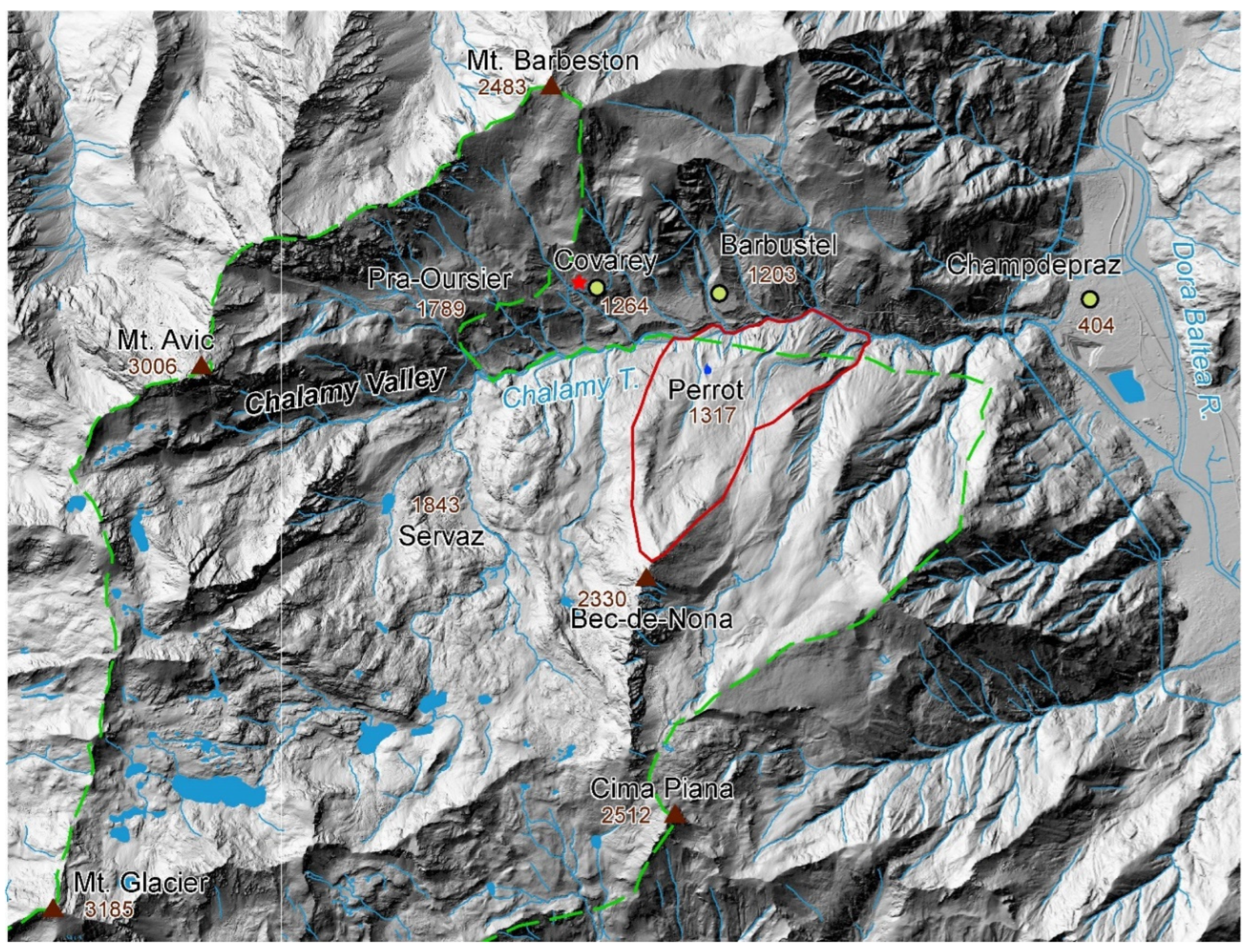
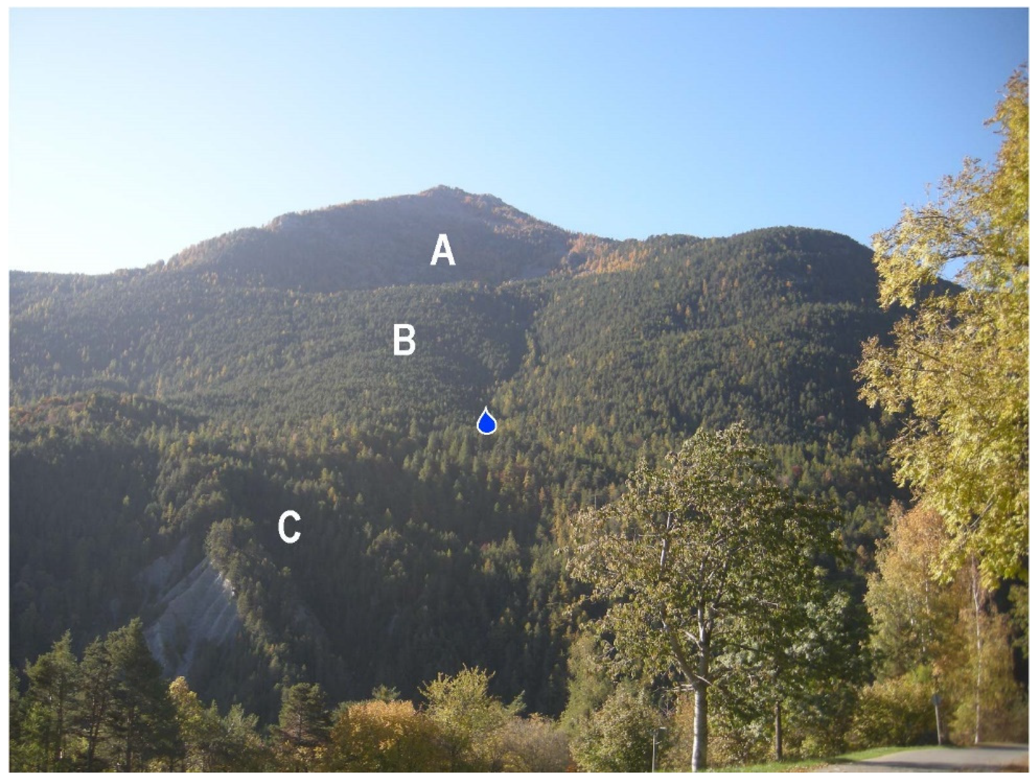
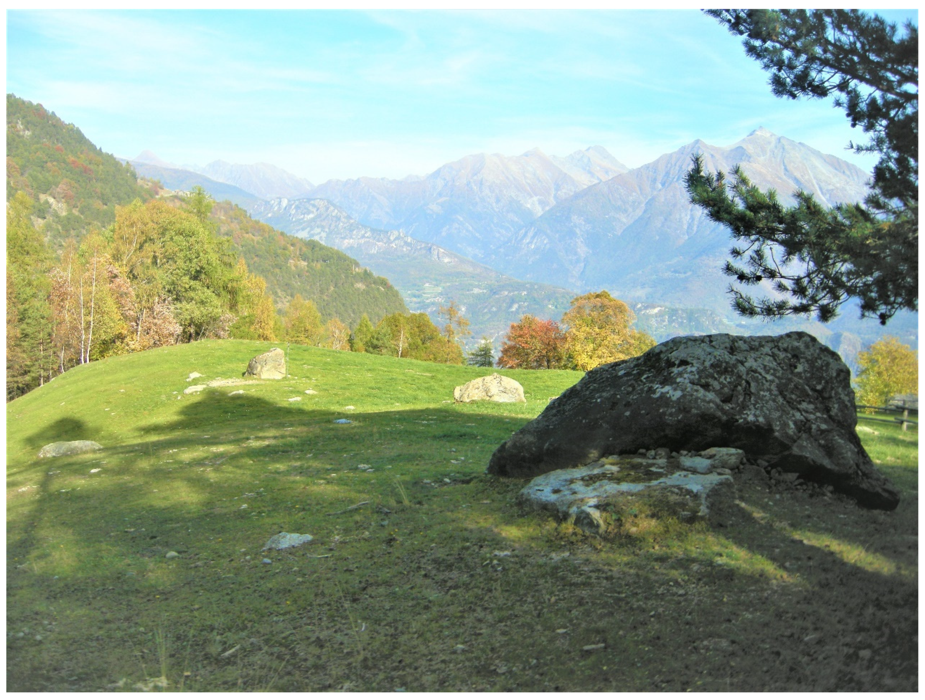
5. Main Features of the Perrot Spring

The Perrot Spring is located within the municipality of Champdepraz on the orographic right of the Chalamy Valley and at an elevation of 1300 m. This spring occurs at the base of the described coarse-grained landslide accumulation, a few meters above the contact with the fine glaciolacustrine sediments, near the incision (approximately 20 m deep) that borders the Bois Pessey landslide accumulation towards the W (Figure 10). Water gushes out into a 20 m high and 200 m long detachment niche, which is shaped in the succession of glaciolacustrine and landslide sediments. This secondary niche is likely due to the evolution of badlands continuously shaped by the water stored in the landslide sediments.
The spring water is taken up by an intake and distributed entirely within the Champdepraz municipality for drinking water use. Discharge and temperature monitoring was carried out from 1 January 2018 to 28 July 2020 with an hourly measurement cadence. During this period, the discharge values were characterized by an average value of 22 l/s, a maximum value of 47 l/s in June 2018, and a minimum value of 4.9 l/s in March 2018.
Discharge variations are controlled by a mountain-type regime [21,22,23] characterized by lower flow rates during the winter and early part of the spring season due to water storage in the form of snow and ice and flow rate maxima in the summer and fall months related to rising air temperatures, resulting in snowmelt and heavy precipitation, respectively. The temperature of the spring water appears to be almost constant, varying little during the hydrological year around an average temperature of 5.00 °C with a maximum of 5.19 °C and a minimum of 4.97 °C. The low temperature of the Perrot Spring water allows it to be classified as cold according to the Mouren classification [24].

6. Discussion and Conclusions

The geological setting of the investigated area reveals metamorphic bedrock that essentially consists of serpentinite diffusely covered by the Quaternary deposits. This bedrock is generally impermeable, even though it shows fractures in and around the investigated area, which can lead to a certain degree of permeability via fracturing.
The glacial sequence outcropping in the Chalamy Valley appears very thick (up to 240 m) and widely outcrops due to the presence and extension of badlands. The subglacial lower sediments, with a visible thickness of approximately thirty meters and characterized by abundant sandy-silty matrix containing subordinate clasts, were transported and deposited at the base of the Chalamy Glacier directly on the bedrock. The significantly overconsolidated facies is derived from their transport at the base of a thick glacial mass. The superimposed ice marginal deposits, with thickness approximately varying from 100 to 150 m, are formed essentially by clasts of very different sizes mixed in a subordinate matrix and rich in very large boulders up to 1000 m3; they are instead deposited at the edges of the Chalamy Glacier on the subglacial sediments. The ice marginal deposits form two lateral moraines preserved on the two sides of the valley, which are characterized by two evident, partly preserved, longitudinal E–W crests. These sediments show a bedding towards the external edges of the moraines (Figure 10).
The glaciolacustrine sediments, which end the glacial sequence with thicknesses up to approximately a hundred meters, are formed by alternating fine- and coarse-grained sediments. The most abundant fine sediments show a sandy-silty matrix in which some centimetric to decimetric clasts are embedded and are characterized by planar-parallel bedding with slight dips towards the SSE between 10° and 30°. These alternating fine- and coarse-grained sediments are typical of lakes located at the edge of a glacier, which are fed directly by lacustrine sedimentation or by landslides from the moraines. This type of sediment shows typical facies and local deformations by glaciotectonics and is also diffused in the low sectors of several tributaries of the Dora Baltea Valley. It was reported as deposited in a glacial barrier lake formed at the edge of the Dora Baltea Glacier at the confluence of the tributary valleys [18]. Similar glaciolacustrine sediments were, for example, observed in the Valensanaz delta fan at Quart.
The widely distributed glacial and glaciolacustrine sediments in the investigated area have been referred to as the Excenex Subsynthem (IVR3), which includes deposits abandoned by glaciers during the third phase of the LGM [18]. They are the most extensive and thick deposits that are also widely distributed in the main Dora Baltea Valley, of which they cover both sides with a certain continuity at low altitudes.
The nature of sediments in the studied glacial succession strongly controlled the morphological appearance. The walls formed by ice marginal sediments are steep and characterized by prominent boulders, whereas the badlands shaped in the glaciolacustrine sediments are subvertical and without prominent boulders in relation to the high consolidation. The overlying landslide sediments are instead coarse-grained, formed by prevalent clasts of various sizes mixed in a subordinate sandy-silty matrix. These sediments form a convex fan that partly covers the glaciolacustrine terrace with weak slope towards the E (Figure 10).
The Quaternary succession, which is particularly thick in the investigated area, greatly influences the genesis of the Perrot Spring. In detail, the overlapping of permeable landslide sediments on poorly permeable glaciolacustrine sediments, which form a wide glaciolacustrine terrace, determines the contact between sediments with different permeability. This overlapping results in a permeability limit that allows the emergence of water. In detail, the water stored in the permeable landslide body is concentrated near the limit with the glaciolacustrine sediments which form an aquiclude, in relation to their fine matrix. The presence of wide badlands, due to the runoff water, indicates that the entire right slope of the middle Chalamy Valley is characterized by a large amount of water. Badlands are in fact typical of runoff water involving steep slopes and sediments characterized by low permeability [25]. The presence of this large amount of water is also supported by the presence of other springs in the same position in other sectors of the studied stretch of the valley.
However, field observations suggest differences between the western sector of the investigated area, where the glaciolacustrine terrace is buried, and its eastern sector, where this surface crops out. The western sector shows an ephemeral stream (Pian di Fort Torrent) that is often devoid of water and has substantial runoff only during major rainfall events or due to snowmelt. This sector is thus characterized by an ephemeral watercourse, although it is fed by a relatively large basin (1.1 km2) that drains the main detachment niche, i.e., both the E-facing scarp and the NW-facing scarp. The Perrot Spring, located approximately 100 m E of the Pian di Fort Torrent, has instead a continuous flow of water. Most of the water stored in this sector at the base of the landslide accumulation feeds the important Perrot Spring through underground paths. This observation suggests a subsoil outflow towards this spring that takes away from the watercourse most of the runoff. The location of this spring in a secondary detachment niche, involving both the glacial sediments and the distal landslide body, suggests that the abundance of the subsoil water also favors the local instability of the slope.
In contrast, the eastern sector of the investigated area (surroundings of Fossè) is drained by the Pianaz T. and Pelode T. Although both are characterized by small catchment basins (0.30 and 0.60 km2, respectively), they show a considerable amount of surficial water downstream of the glaciolacustrine–landslide contact. The catchment basins in the Fossè area only correspond to a small sector of the landslide accumulations (Pianaz T.) and to the ridge located at the E of the Bois Pessey landslide (Pelode T.). The water abundance is demonstrated by the high discharge of these streams and the existence of numerous small emergencies. Consequently, the water stored at the base of the landslide accumulations feeds the watercourses. The large amount of water in this sector is also responsible for the deep valley incisions in the glacial deposits to the E of Fossé. In detail, the Pelode T. becomes an important watercourse downstream of the contact between the glaciolacustrine and landslide sediments that conveys the water stored in the landslide accumulation.
The landslide sediments in the upper sector of the right slope lie directly on the serpentinite bedrock, whose features can influence the feeding of the Perrot Spring. In detail, the important fractures affecting the bedrock can favor the inflow of water from the niche towards the base of the landslide accumulation and debris. The fractured bedrock can also convey water out of the investigated area. Consequently, the spring is also conditioned by the large catchment basin in which it is located.
The nonconstant discharge of the Perrot Spring is a consequence of the mountain rainfall regime, which consists of lower flow rates during the winter and early part of the spring due to water storage in the form of snow and ice, and flow rate maxima in the summer and fall months related to rising air temperatures resulting in snowmelt and heavy precipitation. The constant and relatively low temperature of this spring testifies to a relatively deep circuit, which is not only fed by the landslide body. This circuit could have a component of fractures in the bedrock draining water from higher elevations.

Author Contributions

Conceptualization, M.G.F. and M.G.; methodology, M.G.F., M.G. and D.A.D.L.; Software, S.G. and L.M.S.Q.; validation, M.G.F., M.G. and D.A.D.L.; formal analysis, M.G.F., M.G. and S.G.; investigation, M.G.F., M.G. and S.G.; resources, M.G.F., M.G. and D.A.D.L.; data curation, S.G.; writing—original draft preparation, M.G.F., M.G. and D.A.D.L.; writing—review and editing, M.G.F., M.G. and D.A.D.L.; visualization, S.G. and L.M.S.Q.; supervision, M.G.F. and M.G.; project administration, M.G.F., M.G. and D.A.D.L.; funding acquisition, M.G.F., M.G. and D.A.D.L. All authors have read and agreed to the published version of the manuscript.

Funding

This research was funded by [Domenico Antonio De Luca] grant number [DELD_CT_RIC_22_01- Convenzione con ENTE PARCO NATURALE MONTE AVIC] and [Andrea Festa] grant number [FESA_RILO 2022- Evoluzione tettonico-sedimentaria di complessi di subduzione esumati e ricadute sulla mitigazione dei rischi naturali] and The APC was funded by [DELD_CT_RIC_22_01 and FESA_RILO 2022].

Data Availability Statement

I point out that all data are collected on the field by the authors and are published here for the first time. I do not use pubblic or private data sets.

Acknowledgments

The authors thank the Mont Avic Natural Park Authority for the data made available and cooperation during the investigation.

Conflicts of Interest

The authors declare no conflict of interest.

References

  1. Stevenazzi, S.; Zuffetti, C.; Camera, C.A.S.; Lucchelli, A.; Beretta, G.P.; Bersezio, R.; Masetti, M. Hydrogeological characteristics and water availability in the mountainous aquifer systems of Italian Central Alps: A regional scale approach. J. Environ. Manag. 2023, 340, 117958. [Google Scholar] [CrossRef] [PubMed]
  2. Viviroli, D.; Weingartner, R. The hydrological significance of mountains: From regional to global scale. Hydrol. Earth Syst. Sci. 2004, 8, 1017–1030. [Google Scholar] [CrossRef]
  3. Neuman, S.P. Trends, prospects and challenges in quantifying flow and transport through fractured rocks. Hydrogeol. J. 2005, 13, 124–147. [Google Scholar] [CrossRef]
  4. Grappein, B.; Lasagna, M.; Capodaglio, P.; Caselle, C.; De Luca, D.A. Hydrochemical and isotopic applications in the Western Aosta Valley (Italy) for sustainable groundwater management. Sustainability 2021, 13, 487. [Google Scholar] [CrossRef]
  5. De Luca, D.A.; Cerino Abdin, E.; Forno, M.G.; Gattiglio, M.; Gianotti, F.; Lasagna, M. The Montellina Spring as an example of water circulation in an Alpine DSGSD context (NW Italy). Water 2019, 11, 700. [Google Scholar] [CrossRef]
  6. Gizzi, M.; Lo Russo, S.; Forno, M.G.; Cerino Abdin, E.; Taddia, G. Geological and hydrogeological characterization of springs in a DSGSD context (Rodoretto Valley—NW Italian Alps). Appl. Geol. 2020, 3–19. [Google Scholar] [CrossRef]
  7. De Luca, D.A.; Destefanis, E.; Forno, M.G.; Fratianni, S.; Gattiglio, M.; Masciocco, L.; Menegon, A. Studio interdisciplinare per il monitoraggio e la valorizzazione delle sorgenti della Valle di Susa in previsione di opere a forte impatto ambientale. Convegno Nazionale AIGeo: Ambiente geomorfologico e attività dell’uomo. Risorse rischi e impatti. Torino 28–30 marzo 2007. Mem. Soc. Geogr. Ital. 2009, 87, 189–199. [Google Scholar]
  8. Forno, M.G.; Gattiglio, M.; Gianotti, F. Geological context of the Becca France historical landslide (Aosta Valley, NW Italy). Alp. Med. Quat. 2012, 25, 125–140. Available online: https://hdl.handle.net/2318/120521 (accessed on 17 August 2023).
  9. Galleani, L.; Vigna, B.; Banzato, C.; Lo Russo, S. Validation of a vulnerability estimator for spring protection areas: The vespa index. J. Hydrol. 2011, 396, 233–245. [Google Scholar] [CrossRef]
  10. Sada, D.W.; Pohlman, K.F. Mojave Inventory and Monitoring Network Spring Survey Protocols: Level I and level II. In US National Park Service; Desert Research Institute: Reno, NV, USA, 2003; 32p. [Google Scholar]
  11. Stevens, L.E.; Schenk, E.R.; Springer, A.E. Springs ecosystem classification. Ecol. Appl. 2021, 31, e2218. [Google Scholar] [CrossRef]
  12. Ghignone, S.; Balestro, G.; Gattiglio, M.; Borghi, A. Structural evolution along the Susa Shear Zone: The Role of a first-order shear zone in the exhumation of meta-ophiolite units (Western Alps). Swiss J. Geosci. 2020, 113, 17. [Google Scholar] [CrossRef]
  13. Beltrando, M.; Compagnoni, R.; Lombardo, B. (Ultra-) High-Pressure Metamorphism and Orogenesis: An Alpine Perspective. Gondwana Res. 2010, 18, 147–166. [Google Scholar] [CrossRef]
  14. Pezzotta, F.; Diella, V.; Guastoni, A. Scandium silicated from the Baveno and Cuasso al Monte NYF-Granites, Southern Alps (Italy): Mineralogy and genetic inferences. Am. Mineral. 2005, 90, 1442–1452. [Google Scholar] [CrossRef]
  15. Tartarotti, P.; Benciolini, L.; Monopoli, B. Brecce serpentinitiche nel massiccio ultrabasico del Monte Avic (Falda Ofiolitica Piemontese): Possibili evidenze di erosione sottomarina. Atti Ticinensi Sci. Terra 1998, 7, 73–86. [Google Scholar]
  16. Fontana, E.; Panseri, M.; Tartarotti, P. Oceanic relict textures in the Mount Avic serpentinites, Western Alps. Ofioliti 2008, 33, 105–118. [Google Scholar]
  17. Fontana, E.; Panseri, M.; Tartarotti, P. Geological map of the Mount Avic Massif (Western Alps Ophiolites). J. Maps 2015, 11, 126–135. [Google Scholar] [CrossRef]
  18. Dal Piaz, G.V.; Gianotti, F.; Monopoli, B.; Pennacchioni, G.; Tartarotti, P.; Schiavo, A. Note Illustrative Della Carta Geologica d’Italia Alla Scala 1:50.Foglio 091 “Chatillon”; ISPRA: Rome, Italy, 2010; 152p. [Google Scholar]
  19. Akulov, N.I.; Rubtsov, M.N. Deposits from the Glacial Age at Lake Baikal. Earth Environ. Sci. 2011, 14, 329–362. [Google Scholar] [CrossRef]
  20. Castello, P. La “via del rame” tra la miniera di Hérin e lo stabilimento metallurgico di Perrot nel vallone del Torrente Chalamy in comune di Champdepraz (Valle d’Aosta -Italia). Rev. Valdôtaine Hist. Nat. 2020, 74–75, 55–92. [Google Scholar]
  21. Lucianetti, G.; Penna, D.; Mastrorillo, L.; Mazza, R. The Role of Snowmelt on the Spatio-Temporal Variability of Spring Recharge in a Dolomitic Mountain Group, Italian Alps. Water 2020, 12, 2256. [Google Scholar] [CrossRef]
  22. Clow, D.W.; Schrott, L.; Webb, R.; Campbell, D.H.; Torizzo, A.; Dornblaser, M. Ground water occurrence and contributions to streamflow in an alpine catchment, Colorado Front Range. Groundwater 2003, 41, 937–950. [Google Scholar] [CrossRef]
  23. Penna, D.; Engel, M.; Mao, L.; Dell’Agnese, A.; Bertoldi, G.; Comiti, F. Tracer-Based Analysis of Spatial and Temporal Variations of Water Sources in a Glacierized Catchment. Hydrol. Earth Syst. Sci. 2014, 18, 5271–5288. [Google Scholar] [CrossRef]
  24. Celico, P. Prospezioni Idrogeologiche; Liguori: Napoli, Italy, 1986; Volume 2, 536p. [Google Scholar]
  25. Castiglioni, G.B. Geomorfologia; UTET: Torino, Italy, 1979; 436p. [Google Scholar]
Figure 1. The Mont Avic Natural Park (defined by green line), including the Mont Avic and Mont Glaciers reliefs; the park also comprises the Chalamy Valley that is characterized by a wide valley floor and hosts numerous lakes. The investigated area (red line), Perrot Spring (blue drop symbol), and visitor’s center (red asterisk) are also reported.
Water 15 03042 g001
Figure 2. Sketch of the Western Alps with the location of the investigated area (asterisk) (modified from [12]).
Water 15 03042 g002
Figure 3. Glacial shaping in the Chalamy Valley, highlighted by steep rocky slopes and a wide valley floor, deeply engraved by the Chalamy Torrent. In the background is the sharp silhouette of Mont Avic.
Water 15 03042 g003
Figure 4. Serpentinite outcropping in the valley floor of the Chalamy Valley showing evident glacial shaping forming typical roche moutonnée.
Water 15 03042 g004
Figure 5. Different altitude bands observed in the right slope of the middle Chalamy Valley in which the Perrot Spring (drop) is located: (A) high walls shaped in bedrock; (B) intermediate sector of the slope that is discontinuously covered by gravitational and debris sediments; (C) low sector of valley floor filled by a complex sequence of Quaternary sediments.
Water 15 03042 g005
Figure 6. Geological map of the right slope of the middle Chalamy Valley.
Water 15 03042 g006
Figure 7. Thick sequence of subglacial (S), ice marginal (I), and glaciolacustrine (G) sediments observed in the middle Chalamy Valley, exposed by wide badlands.
Water 15 03042 g007
Figure 8. Ice marginal sediments observed in the right slope of the middle Chalamy Valley showing a concentration of clasts (C) and large boulders (B) along the moraine ridge covered by glaciolacustrine sediments (G).
Water 15 03042 g008
Figure 9. Large gravitational boulders that reached the glaciolacustrine terrace near Bossè.
Water 15 03042 g009
Figure 10. Schematic (not to scale) cross-section of the right slope of the Chalamy Valley with the location of the Perrot Spring (blue drop symbol) near the contact between glaciolacustrine and landslide sediments. The blue lines refer to two different levels of the Chalamy Glacier during the deposition of ice contact and glaciolacustrine sediments. The fractures in the bedrock favor the flow of the rainwater from the high slope towards the landslide deposits, which feed the Perrot spring. See Figure 6 for the legend.
Water 15 03042 g010
Disclaimer/Publisher’s Note: The statements, opinions and data contained in all publications are solely those of the individual author(s) and contributor(s) and not of MDPI and/or the editor(s). MDPI and/or the editor(s) disclaim responsibility for any injury to people or property resulting from any ideas, methods, instructions or products referred to in the content.

