Article

Soil Macropore and Hydraulic Conductivity Dynamics of Different Land Uses in the Dry–Hot Valley Region of China

1
Key Laboratory of Ministry of Education on Land Resources Evaluation and Monitoring in Southwest China, Sichuan Normal University, Chengdu 610068, China
2
College of Geography and Resources, Sichuan Normal University, Chengdu 610066, China
3
Engineering Research Center for the Development of Farmland Ecosystem Service Functions, Chengdu 610068, China
4
China Academy of Transportation Sciences, Beijing 100029, China
5
State Key Laboratory of Geohazard Prevention and Geoenvironment Protection, Chengdu University of Technology, Chengdu 610059, China
*
Authors to whom correspondence should be addressed.
Water 2023, 15(17), 3036; https://doi.org/10.3390/w15173036
Submission received: 26 June 2023 / Revised: 7 August 2023 / Accepted: 15 August 2023 / Published: 24 August 2023
(This article belongs to the Special Issue Soil Dynamics and Water Resource Management)

Abstract

:
Soil macropores and hydraulic conductivity are important indexes used to describe soil hydrology. In the dry-hot valley region of Southwest China, with its dramatic seasonal dry–wet rhythm, soil properties and hydraulic conductivity can reflect unique dynamics as determined by the interaction between land use and the seasonal dry–wet cycle. In this study, the soil macropore characteristics and hydraulic conductivity of five land uses (traditional corn, plum orchard, pine forest, grassland, and abandoned cropland) in a dry–hot valley region were quantified using X-ray computed tomography (CT) and a mini disk infiltrometer in the rainy season (July) and dry season (November), respectively. The results showed that the soil macropore indexes (soil macroporosity, mean diameter of macropores, connectivity, hydraulic radius and compactness) in the rainy season were, on average, 1.26 times higher than those in the dry season. Correspondingly, the hydraulic conductivity of different land uses in the rainy season was significantly higher than those in the dry season (2.10 times higher, on average). Correlation analysis and principal component analysis (PCA) indicated that the hydraulic conductivity was mainly determined by soil macropore parameters rather than by general soil properties, such as organic matter (OM) and bulk density (BD). The hydraulic conductivity for the five land uses followed the order of PF > GL > TC > PO > AC in both the rainy and the dry seasons. This ranking order reflects the protective effect of vegetation in reducing raindrop splash and soil crust formation processes. The above results can help guide soil water conservation and vegetation restoration in the dry-hot valley region of Southwest China.

1. Introduction

Soil hydraulic conductivity can affect rainfall infiltration and surface runoff generation processes, thus playing an important role in the mechanism that determines water balance [1]. Hydraulic conductivity is a key parameter in hydrological models [2,3]. Quantifying hydraulic conductivity is critical to simulate the hydrological process and predict soil erosion risk, and in turn, can benefit local soil and water resource management [4]. Soil hydraulic conductivity is influenced by soil chemical and physical properties, such as soil particle size, soil moisture, and soil pore characteristics [5]. Among them, soil macropores were reported as the main factor determining hydraulic conductivity, overriding other indicators of soil properties [6]. Soil macropores mainly affect water infiltration rate, soil permeability and the soil’s water-holding capacity [7]. Macropore flow may be greater than water flow by more than 70%, though macropores account for only approximately 0.1% of the total soil volume [8].
The contribution of macropores to water flow has been based mainly on the three-dimensional (3D) geometry and topology of macropores. Soil macroporosity, macropore size, macropore number, macropore complexity and macropore connectivity are considered significant characteristics that influence soil water movement [9]. With technological advances in X-ray computer tomography (CT), many studies began to use the CT scanning method to analyze the three-dimensional structure of soil pores. The biggest advantage of this technology is that it can quickly visualize the inner structure of soil without destruction [10]. Integrated 3D imaging and image analysis technology can accurately quantify pore parameters such as the number of macropores, macropore diameter, and macroporosity [11].
Land use practices have a great effect on water movement by changing soil macropore characteristics [12]. Cultivation practices, vegetation types, ground coverage and plant root growth differ greatly among different land use types, which significantly affect soil pore characteristics and then determine soil water conductivity [6]. For example, woodland and grassland soils that generally have rich plant species diversity and less external disturbance showed more connected pore networks than those of cultivated soil [13]. Bacq-Labreuil et al. (2018) [14] also indicated that the total porosity of grassland was higher than that of cultivated land. Traditionally cultivated land may disrupt pore network connectivity due to farming disturbance, and its infiltration rate is lower than that of permanent pastures [15]. The soil infiltration rate of forestland was much greater than that of grassland [16], and it is often 2 to 4 times higher than the infiltration capacity of cultivated land [17].
In addition to the influence of different land use types, many studies have indicated that soil macropore characteristics and hydraulic conductivity change temporally due to climate factors [10]. Even for the same land use type, the total porosity and macropore diameter, macropore connectivity, fractal dimension and other macropore characteristics varied significantly with the observation stages, especially in the surface layer (0–10 cm) [18,19]. Climatic conditions, such as the wetting and drying cycles associated with seasonal changes, could affect the number of soil macropores, macroporosity and macropore connectivity, which lead to changes in hydraulic conductivity [20]. Therefore, soil hydraulic conductivity is a highly dynamic soil property that is influenced by land use and management, natural disturbances and dry–wet cycles, such as seasonal changes [21]. Considering the high environmental variability, knowledge about the interaction between land use and the effects of dry–wet cycles on water infiltration processes is still limited and should be given more attention.
The dry–hot valley region of Southwest China is characterized by hot weather with distinct wet and dry seasons [22]. The uneven distribution of annual rainfall in this region leads to different soil water responses. On the one hand, the concentrated rainfall in the rainy season might cause severe soil erosion. On the other hand, the long duration of the dry season (nearly half a year) and the high evaporation could lead to serious water deficits, and soil moisture could be a critical limiting factor for the local ecosystems [23,24]. Due to the above reasons, the dry–hot valley region has been recognized as an ecologically fragile area in the upper reaches of the Yangtze River [25]. It is of vital importance to clarify the soil water infiltration process and its occurring mechanisms in different land use types in this region. Based on traditional experiments, such as double-rings, some scientists compared and ranked the infiltration capacity of different land use types in the dry–hot valley area [26]. Influential factors were examined by exploring the relationship between infiltration capacity and conventional soil properties, such as bulk density [27]. Nevertheless, limited research has been conducted on the response mechanism of soil water conductivity as determined by the soil macropores characteristics in this region.
This study assumed that different land use superimposed dry–wet cycles in this area will lead to corresponding changes in soil characteristics. These results provide a typical aspect to explore the interaction between land use and dry–wet cycle effects on soil pore characteristics and hydraulic conductivity. The existing research showed that the temporal variability of soil macropore and hydraulic conductivity could be quantified based on two stages of samplings in wet and dry seasons, respectively [5,19]. Therefore, this study would perform sampling and infiltration experiments in wet and dry conditions. It is representative of local agriculture, which harvests once a year in the rainy season and is fallow in the dry season [28]. The objectives of this study were to (i) evaluate the temporal dynamics of soil macropore characteristics and hydraulic conductivity in two seasons under different types of land use and (ii) identify the concomitant change in the relative contribution to hydraulic conductivity for different macropore characteristics. The results of this study provide a better understanding of the connections between hydraulic conductivity and macropore characteristics in dry-hot climate regions such as Southwest China.

2. Materials and Methods
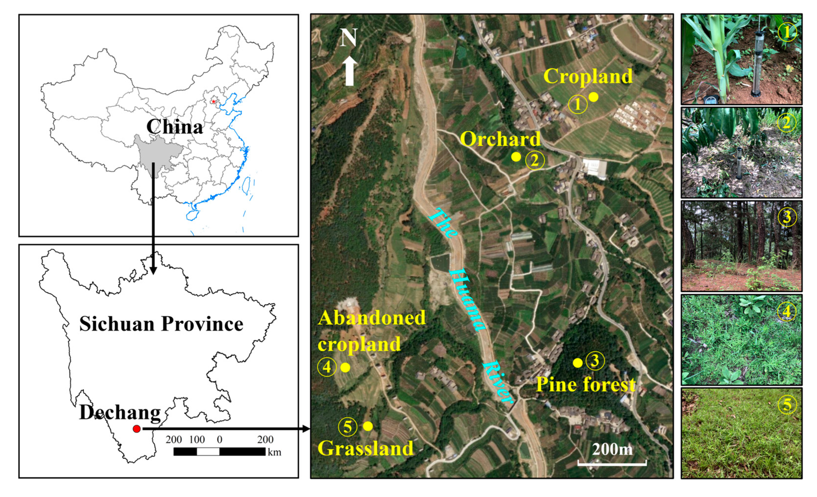
2.1. Study Area

The selected study area is in Dechang County, Liangshan Prefecture, Sichuan Province, with a specific location of 102°11′5″ E, 27°19′40″ N. It is approximately 70 km south of Xichang and within the dry–hot valley region that is described by Shen et al. (2003) [29]. The elevation ranges from 1360 m to 1450 m. This area belongs to a typical subtropical climate zone, and the average annual temperature is 17.7 °C. There are as many as 350 days when the temperature is above 10 °C every year. The mean temperature of the coldest month is over 12 °C, while the mean temperature of the warmest month is between 24 and 28 °C [30]. The average annual precipitation is 800–1100 mm and is severely unevenly distributed. June to October is considered the wet season, with 80–90% of precipitation concentrated in this period. The hot, dry season (November–May) receives approximately only 10% of the annual rainfall. In this region, the dominant soil type could be classified as Red Soil according to the Chinese Soil Database [31] and the Soil Series of Sichuan [32] with the typical soil profile data listed in Table 1. According to the World Reference Base (WRB) international soil classification system, the local soils are Lixisols, which have low leaching and high soil expansion due to climate conditions [33]. The soil formed in quaternary fluvial-lacustrine deposits is vulnerable to erosion [34]. The main types of land use in the area include agricultural land, forestland and natural grassland, accounting for 5.3%, 53% and 40% of the total land area, respectively. Forestland mainly includes the following plant species: Pinus yunnanensis, Pinus yunnanensis, and Quercus alpine. Agricultural lands can also be subdivided into croplands and orchards.

2.2. Sampling Sites and Methods

Five land use types were sampled to study the pore characteristics and hydraulic conductivity. These five typical local land uses (Figure 1) include traditional corn (TC), plum orchard (PO), pine forest (PF), grassland (GL), and abandoned cropland (AC). The experimental sites are distributed on two sides of the Huama River. Brief descriptions of the five land uses are shown in Table 2. Soil sample collection and field in situ infiltration experiments to quantify soil hydraulic conductivity was carried out approximately one month after the rainy season (July, average soil water content: 23.6%) and dry season (November, average soil water content: 8.4%), respectively.

2.3. Soil Samples

For investigations of the soil structure by X-ray computed tomography, the undisturbed soil columns from the topsoil were also sampled with polyvinyl chloride (PVC) cylinders beveled at the bottom. The PVC cylinders were 10 cm in depth and 10 cm in diameter, with a 3 mm thick wall. The soil column extraction followed the procedure of Hu et al. (2016) [35]. To protect soil columns and avoid moisture loss, the freshly collected samples should be packed into cling film immediately and then placed in shock-absorbing boxes with Styrofoam (Figure 2a). All of the soil columns should be carefully transported to the laboratory to avoid external interference and destruction, and samples should be stored at 4 °C until further analysis. Three soil columns were randomly sampled from each land use type in the rainy season and the dry season, respectively. A total of 30 undisturbed soil columns were obtained from the five land uses for both seasons.
Meanwhile, for the analysis of routine soil properties, three soil surface samples (0–10 cm) were collected at random to determine bulk density (BD), soil organic matter (SOM) and the soil particle size from the different land uses every time. In addition, the mean weight diameter (MWD) and the percentage content of water-stable aggregates greater than 0.25 mm (WSA0.25) were also analyzed, which can characterize the stability of soil aggregates. The analyses of all these soil properties followed the standard soil experimental procedure.

2.4. CT Scanning and Image Analysis

A medical X-ray tomograph (GE Light Speed V, General Electric, Boston, MA, USA), a 64-slice spiral CT of Sichuan Friendship Hospital, was used to scan all the soil columns at an energy level of 120 kV, 120 mA and 1 s exposure time with a 0.625 mm scanning interval. Each soil column was generated from approximately 160 images with 512 × 512 pixels per slice for a field of view of 135.48 mm × 135.48 mm. The voxel was a resolution of 0.265 × 0.265 × 0.625 mm in the reconstructed image [36]. The images were in DICOM format with 16 bits and then converted to TIFF format for further analysis. Because of the limited resolution of the scanning system, this study mainly quantified pores with a diameter greater than 1.2 mm (more than 2 voxels in width), which were classified as macropores [37].
Image processing was performed by ImageJ (Version 1.52a), which is a digital image processing program developed by the US National Institutes of Health. First, a grayscale image stack was reconstructed to a new voxel cube of 0.265 mm × 0.265 mm × 0.265 mm to facilitate further analysis based on scanning slices [36]. Then, a region of interest (ROI) 96.31 mm in diameter and 87.5 mm in height was selected from the central part of the soil cores using the Clear Outside Tools in ImageJ to avoid artifacts at the boundary region caused by sampling (Figure 2b). Next, 16-bit images were transformed into 8-bit images to save memory. Afterward, a median filter was used to reduce the noise before image segmentation [38]. The images were segmented using the global threshold method based on the intensity histogram of the entire sample as described by Udawatta et al. (2006) [13]. In this study, we also used an artificial macropore with a known diameter to determine the thresholding for image segmentation; for the detailed process, refer to Hu et al. (2016) [35] and Budhathoki et al. (2022) [19]. After segmentation, the 8-bit grayscale images were converted into binary images, which means that the black areas were considered pores and the white areas represented soil solids [39].

2.5. Macropore System Analysis

In this study, the hydraulic radius of macropores (HD), macroporosity, compactness (CP), global connectivity (Γ) and mean diameter of the macropore (MD) were selected as macropore indexes. These indexes could be obtained using the ImageJ plug-in 3D object counter plug-in [40]. The 3D object counter plug-in was first used to remove macropores smaller than 8 voxels from the porous fraction of the images to avoid potential unresolved dubious features [41]. Second, the plug-in in image J, for example, the number of unconnected pores and characteristics of the individual pores, were adopted to analyze the above soil pore parameters. The volume and surface area of each macropore could be quantified from the Analyze Particles Tool, and the ratio of the amount of macropore volume to the amount of macropore surface area was defined as the HD. The macroporosity was determined by estimating the ratio between the total macropore volume of a scan and the volume of the ROI. The CP is a macropore shape factor, which increases in value as the macropore deviates from the sphere. Elongated and tubular pores are more conducive to water infiltration [33]. Γ represents the connectivity of soil pores, which reflects the probability that two pores belong to the same pore, and the value ranges from 0 to 1. When all pores are connected in one percolating pore, the value is close to 1. The MD was determined with the local thickness algorithm in the Bone-J plug-in of ImageJ [42]. The CP, Γ, and MD were calculated by the following equations:
c o m p a c t n e s s = A 1.5 V
Γ = i = 0 n V i 2 i = 0 n V i 2
M D = i = 1 n D i V i i = 1 n V i
where A is the surface area of the macropore, Di and Vi are the diameter and the volume of each macropore, respectively, and n is the number of isolated macropores [34].

2.6. Soil Hydraulic Conductivity

While collecting soil column samples, in situ infiltration experiments were carried out to measure the near-saturated soil hydraulic conductivity of different land uses with a mini disk infiltrometer (MDI) [43]. The device can reduce soil disturbance and save water consumption during infiltration processes. In each period, 30–50 repeated infiltration experiments were carried out for each land use, and a total of approximately 400 infiltration experiments were carried out in this study.
In this study, a suction rate of 2 cm and a time interval of 3 min were set for different land uses based on the Infiltrometer User’s Manual (2007). At the beginning of the experiment, the starting water volume in the reservoir of MDI was recorded, and then it was placed on a smooth soil surface to ensure good contact between the infiltrometer bottom and the soil. Soil water infiltration volume was measured at the selected suction head according to the time interval of MDI observations [44]. In turn, cumulative infiltration was obtained by dividing the infiltrated water volume by the infiltrated area. Soil hydraulic conductivity could be determined following the procedures and functions described by Zhang (1997) [45]. First, cumulative infiltration (I, cm) was fitted with time based on the following function:
I = C1t + C2t1/2
where I is the cumulative infiltration, C1 is the slope of the fitting curve between the cumulative infiltration and the square root of time, which is related to hydraulic conductivity, C2 is soil sorptivity, and t is time (min). Then, the hydraulic conductivity (Kh) is calculated as follows:
Kh = C1/A
where A is a value related to the van Genuchten parameters and could be calculated by the formula proposed by [46].

2.7. Statistics Analysis

In this study, the statistical analysis software SPSS 20.0 and ORIGIN 2022 for Windows were applied for the data analysis and graphical displays, respectively. Significant differences in hydraulic conductivity, macropore characteristics and soil properties among different treatments were analyzed with one-way ANOVA and Fisher’s test, calculated at the p = 0.05 level. Pearson correlation analysis (R) was used to test the relationships among hydraulic conductivity, macropore characteristics and soil properties. The results were reported at the p < 0.05 and p < 0.01 levels of significance. Principal component analysis (PCA) was used to analyze the main factors influencing the soil hydraulic conductivity.

3. Results

3.1. Temporal Changes in Basic Soil Properties of Different Land Uses

The soil particle sizes in the top 10 cm for the five land use types are given in Figure 3. Based on the composition ratio of silt, sand and clay, the soil texture (according to the USDA classification) of TC, GL, PF, PO and AC could be classified as clay loam, loam, sandy clay loam, silt loam and sandy loam, respectively. Soil organic matter is beneficial to the formation of soil aggregates. Compared with the average values of soil properties in the two seasons (Table 3), the organic matter barely changed. The bulk density, MWD, and WSA0.25 values in the dry season are slightly higher than those in the rainy season. In the same season, PF and GL had significantly higher MWD, WSA0.25 and soil organic matter than the three other land uses. There was little change in bulk density among different land uses.

3.2. Soil Macropore Structure Characteristics under Different Land Uses

The macropore properties of five land uses in two seasons were distinguished (Table 4). The macropore indicators of the same land use in the rainy season were better than those in the dry season. Comparing the average values of different macropore parameters, the soil macroporosity, MD, connectivity, hydraulic radius and compactness of the rainy season were 1.27 times, 1.16 times, 1.45 times, 1.20 times and 1.22 times more than those of the dry season, respectively. In the same season, the soil macropore characteristics of different land use types were significantly different. Overall, PF had the best macropore characteristics, followed by GL, while AC had the worst pore characteristics. Specifically, the macropore connectivity of pine forests was 7.89 times and 5.88 times greater than that of abandoned cropland in the rainy season and dry season, respectively. Meanwhile, the macropore compactness of PF in the rainy season and dry season was also 78.09% and 74.73% higher than that of abandoned cropland. Both the macroporosity and the connectivity of AC and PO were relatively lower in the two seasons.
To study the variation in macroporosity with depth, the macroporosity distribution for each sample along the ROI depth was determined for each slice with a 0.265 mm increment. Generally, the macroporosity variation with depth followed a similar distribution for all land uses, which decreased with profile depth. In the rainy season, relatively larger fluctuations in macroporosity values along the ROI depth were observed than in the dry season for the five land uses (Figure 4). The growing season of corn coincides with the rainy season, and the macroporosity of TC in the rainy season was significantly higher in the top 60 mm of soil than that in the dry season. Whether in the dry season or rainy season, the fluctuation range of PF and GL macroporosity along the ROI depth was clearly greater than that of the other three land uses.

3.3. Seasonal Variation in Hydraulic Conductivity under Different Land Uses

The hydraulic conductivity of five land uses was statistically analyzed, and the results are shown in Figure 5. The minimum hydraulic conductivity was observed in PO during the dry season, with a value of 0.23 cm/d, and the maximum in PF during the rainy season, with a value of 32.92 cm/d. The standard deviation for PF hydraulic conductivity was much greater in the rainy season. The hydraulic conductivity of soil in the rainy season was significantly better than that in the dry season (p = 0.03). The hydraulic conductivities of TC, PO, PF, GL and AC in the rainy season were 2.67 times, 2.74 times, 2.07 times, 1.86 times and 4.26 times higher than those in the dry season, respectively. There were also significant differences in hydraulic conductivity among different land use types in the same season. Regardless of the season, the hydraulic conductivity of the five land uses can be ranked as follows: PF > GL > TC > PO > AC. The hydraulic conductivity of PF was 63.71% and 82.42% higher than that of AC in the rainy season and dry season, respectively. In addition, the hydraulic conductivity of AC had the largest seasonal difference among all land uses, and its hydraulic conductivity in the rainy season was 76% higher than that in the dry season. In contrast, the hydraulic conductivity for PF in the wet season was only 36.42% higher than that in the dry season, and the seasonal difference was the smallest among all treatments.

3.4. Correlation among Hydraulic Conductivity, Soil Properties and Macropore Characteristics

Correlation analysis among hydraulic conductivity, cumulative infiltration, soil properties and CT-derived macropore parameters of five land uses in two seasons are shown in Figure 6. The results showed that MWD and WSA0.25 decreased significantly with increasing clay content in soil at the 5% significance level (p < 0.05). Soil macroporosity, connectivity and compactness had fairly positive correlations with MWD, WSA0.25 and soil organic matter at the 5% level (p < 0.05) but showed a low correlation with soil particle size. All macropore parameters were significantly positively correlated with each other at the 5% (p < 0.05) and at the 1% level (p < 0.01) level of significance. The MD, HD, CP and Γ generally increased with increasing macroporosity, which is similar to the conclusion of Zhang et al. (2019) [37]. The MD, HD, MP and Γ were strongly positively correlated with compactness, which indicated that the long and cylindrical-shaped macropores with higher CP were more beneficial for increasing other macropore parameters. For all the macropore parameters, the best correlation with hydraulic conductivity was macroporosity (0.81 **), followed by Γ (0.79 **), CP (0.75 *), MD (0.73 *) and HD (0.68 *), while the other soil properties including soil particle size had little correlation with hydraulic conductivity.
PCA was performed to classify 12 soil properties and explore the main factors affecting hydraulic conductivity. The first three main components together explained 86.97% of the total variance in the collected data (Table 5). Figure 7 shows the details of the PCA loadings. The first factor (PC1) alone explained 51.32% of the total variance and had stronger positive loadings on CT-derived macropore parameters, moderate loadings on water-stable aggregation, and weaker loadings on other soil properties. The strong positive loading on macropore parameters agreed with the correlation coefficient results and indicated that soil macropore characteristics were the main factors affecting soil infiltration. Thus, PC1 could be termed the soil macropore factor. The second factor (PC2) and the third factor (PC3) explained 22.80% and 12.85% of the total variance, respectively. PC2 had positive loadings on clay content and silt content and negative loadings on sand content; however, PC3 showed negative loadings on silt content.

4. Discussion

4.1. Effects of Dry–Wet Cycles on Soil Macropores and Hydraulic Conductivity

Soil hydraulic conductivity has been reported as a highly dynamic soil property that is related to the seasonal dry–wet cycle [47]. Some researchers have indicated that surface soil hydraulic conductivities are higher under drier conditions [5]. Scientists believe that soil hydraulic conductivity is negatively correlated with soil bulk density [30] and positively related to organic matter and water-stable aggregates [48]. Inconsistent with the above studies, the results of this study showed that the hydraulic conductivity of five different land uses in the rainy season was significantly higher than that in the dry season (Figure 3). In addition, the weak correlation in Figure 4 might imply that general soil property indexes such as SOM, MWD and bulk density are inadequate in explaining the dynamic variation in hydraulic conductivity in this study. The results of correlation and principal component analysis (Figure 6) showed that soil macropore indexes should be treated as the predominant factors. The significantly higher soil macropore indexes (Table 3) were the main reason for the higher hydraulic conductivity in the wet season than in the dry season.
Soil inherent characteristics might be one aspect driving the dynamics of macropores and hydraulic conductivity. The denatured dry laterite in the study area was characterized by strong expansibility. Scientists have reported that the soil swells and the macropores shrink at the beginning of the dry season because of the wetting process during the rainy season [49]. Meanwhile, the change in soil macropore structure may also be related to rainfall splash, i.e., fine soil particles tend to be easily scattered by raindrops and further clog some soil macropores [50]. The surface soil will gradually seal and form a crust during the rainy season [51], which will lead to lower hydraulic conductivity in the dry season following shortly after (Table 3). This could be verified by Zhang et al. (2016) [18], who reported decreasing soil porosity caused by compaction due to the heavy and concentrated rainfall associated with wetting and drying cycles. On the other hand, some studies based on indoor simulation experiments [20] or under uniform annual precipitation conditions [19] have indicated that wetting and drying cycles can regenerate soil macropores. These inconsistent results reflect the potential of highly accumulated precipitation to reduce soil macropores in the dry-hot valley region. They also imply the complexity of wet–dry seasonal dynamics on the variation in soil hydraulic conductivity.
In addition to soil properties, plant growth should also be considered when exploring the dynamics of soil macropore indexes and hydraulic conductivity. Seasonal variability exerts a deep influence on the soil environment and ultimately changes plant growth mainly through fluctuations in light, temperature and precipitation [52]. The abundance of light, heat and soil water in the rainy season is beneficial to the growth of crops and other plants [53]. The growth and extension of roots were associated with highly continuous soil pores that were cylindric in shape, which would increase the water infiltration capacity [54]. Therefore, the connectivity and compactness of different land uses in the rainy season were evidently greater than those in the dry season.

4.2. Effects of Land Use on Soil Macropores and Hydraulic Conductivity

Land use has been reported to influence soil properties and must be considered when determining soil infiltration capability and hydraulic parameters [55]. In this study, hydraulic conductivities in different land uses were ranked as PF > GL > TC > PO > AC in both dry and wet seasons. This result is consistent with that of previous scientists, who believed that the hydraulic conductivity of natural forests [16] and permanent grassland [15] was better than that of conventionally cultivated plots. The reason may be closely related to the root system and vegetation canopy typical of different land uses, which are the most significant variables affecting soil macropores [56]. For example, the soil macroporosity, connectivity and compactness of PF were generally higher than those of AC both in the rainy season and in the dry season (Table 3). If vegetation coverage and root systems of different land uses indeed play a role, then PF could effectively weaken the kinetic energy of raindrops and reduce soil compaction on the surface with its taller canopy, which would protect soil macropores [57]. Furthermore, PF had a longitudinal root system, and rhizosphere exudates were beneficial to the formation and maintenance of macropores [58]. In addition, compared with conventionally cultivated land, the external disturbance to forest and grassland soils was relatively low. The low disturbance would also be beneficial to forming and maintaining continuous macropores that will accelerate water flow and strongly influence preferential flow transport processes [59]. It should be mentioned that the soils of different sites have quite contrasting textures for the five land uses (Figure 3). Nevertheless, the low correlations in Figure 6 and the PCA results in Figure 7 showed that soil particle size had little influence on soil macropore and hydraulic conductivity variation. The results supported Becker et al. (2018) [60], who reported that soil hydraulic conductivity might be more strongly affected by structural changes rather than soil textural differences.
Notably, the dry–wet seasonal differences in hydraulic conductivity for the five land uses also differ from each other. For example, the hydraulic conductivity of AC and PF had the largest and smallest seasonal differences among all land uses, respectively. These results might reflect the interaction effect of dry–wet cycles and land cover on soil macropore characteristics and hydraulic conductivity. For the AC treatment in which annual herbs were randomly distributed and their coverage was relatively low, raindrops reduced soil macropores throughout the wet season. Analogously, Ren et al. (2016) [61] also indicated that raindrops hit the ground of AC directly and caused natural compaction due to the low vegetation cover in the early restoration stage. This can explain why the macroporosity and connectivity of AC in November were lower than those in July. As mentioned above, the stable vegetation structure of PF, which played an important role in protecting the soil surface, slowed the deterioration of soil macropores from July to November. Therefore, the hydraulic conductivity for PF showed a relatively small variation range between the wet and dry seasons. The above results reflected the importance of multiple vegetation combinations and stable surface coverage to water conservation in the dry–hot valley region.

5. Conclusions

In this study, the soil properties, macropore characteristics and hydraulic conductivity of five typical land uses (traditional corn, plum orchard, pine forest, grassland and abandoned cropland) in the dry–hot valley area were quantified in rainy (July) and dry (November) seasons through a series of experiments. The MDI infiltration experiment showed that soil hydraulic conductivities for different land uses were higher in the rainy season than in the dry season. There were also great differences in the hydraulic conductivity within the same land use between seasons. Soil properties, such as SOM and bulk density of five land uses, changed little from July to November and were weakly related to soil hydraulic conductivity. It might be concluded that these soil indexes are not adequate in describing the infiltration capability in the study area. In fact, our results revealed that soil macropore parameters had significantly positive correlations with hydraulic conductivity and should be treated as the main influential factors. The highly concentrated precipitation in the study played an important role in reducing soil macropores. Correspondingly, the higher soil macropore indexes and hydraulic conductivity in July mainly reflected the vegetation’s protective effect on reducing raindrop splash and soil crust formation processes. This effect was also indicated by the hydraulic conductivity of five land uses, which are ranked PF > GL> TC > PO > AC in both the rainy and dry seasons. Comparing the highest values for pine forests and the lowest values for abandoned cropland reflected the importance of stable vegetation in enhancing soil hydraulics. Multiple combinations of vegetation should be grown for water conservation in the dry–hot valley region of Southwest China.

Author Contributions

Conceptualization, Y.K. and Y.W.; methodology, Y.W. and L.C.; software, J.R.; validation, Y.K. and L.C.; formal analysis, Y.W.; investigation, Y.W. and Y.K.; resources, Y.L.; data curation, Y.L.; writing—original draft preparation, Y.W.; writing—review and editing, L.C.; visualization, W.H.; supervision, Y.K.; project administration, Y.W.; funding acquisition, Y.W. All authors have read and agreed to the published version of the manuscript.

Funding

This research was funded by the National Key Research and Development Program of China, grant number 2021YFB2600105, and the National Natural Science Foundation of China, grant number 41807077.

Data Availability Statement

The data that support the findings of this study are available from the corresponding author upon reasonable request.

Conflicts of Interest

The authors declare no conflict of interest.

References

  1. Sihag, P.; Mohsenzadeh Karimi, S.; Angelaki, A. Random forest, M5P and regression analysis to estimate the field unsaturated hydraulic conductivity. Appl. Water Sci. 2019, 9, 129. [Google Scholar] [CrossRef]
  2. Liu, Q.S.; Liu, G.H.; Huang, C.; Li, H. Variation in soil bulk density and hydraulic conductivity within a quasi-circular vegetation patch and bare soil area. J. Soils Sediments 2020, 20, 2019–2030. [Google Scholar] [CrossRef]
  3. Baiamonte, G. Simplified Model to Predict Runoff Generation Time for Well-Drained and Vegetated Soils. J. Irrig. Drain. Eng. 2016, 142, 04016047. [Google Scholar] [CrossRef]
  4. Santra, P.; Kumar, M.; Kumawat, R.N. Characterization and Modeling of Infiltration Characteristics of Soils Under Major Land Use Systems in Hot Arid Region of India. Agric. Res. 2021, 10, 417–433. [Google Scholar] [CrossRef]
  5. Zhou, X.; Lin, H.S.; White, E.A. Surface soil hydraulic properties in four soil series under different land uses and their temporal changes. CATENA 2008, 73, 180–188. [Google Scholar] [CrossRef]
  6. Bottinelli, N.; Zhou, H.; Boivin, P.; Zhang, Z.B.; Jouquet, P.; Hartmann, C.; Peng, X. Macropores generated during shrinkage in two paddy soils using X-ray micro-computed tomography. Geoderma 2016, 265, 78–86. [Google Scholar] [CrossRef]
  7. Kodešová, R.; Jirků, V.; Kodeš, V.; Mühlhanselová, M.; Nikodem, A.; Žigová, A. Soil structure and soil hydraulic properties of Haplic Luvisol used as arable land and grassland. Soil Tillage Res. 2011, 111, 154–161. [Google Scholar] [CrossRef]
  8. Müller, K.; Katuwal, S.; Young, I.; McLeod, M.; Moldrup, P.; de Jonge, L.W.; Clothier, B. Characterising and linking X-ray CT derived macroporosity parameters to infltration in soils with contrasting structures. Geoderma 2018, 313, 82–91. [Google Scholar] [CrossRef]
  9. Cássaro, F.A.M.; Posadas Durand, A.N.; Gimenez, D.; Vaz, C.M.P. Pore-size distributions of soils derived using a geometrical approach and multiple resolution Micro CT images. Soil Sci. Soc. Am. J. 2017, 81, 468–476. [Google Scholar] [CrossRef]
  10. Galdos, M.V.; Pires, L.F.; Cooper, H.V.; Calonego, J.C.; Rosolem, C.A.; Mooney, S.J. Assessing the long-term effects of zero-tillage on the macroporosity of Brazilian soils using X-ray Computed Tomography. Geoderma 2019, 337, 1126–1135. [Google Scholar] [CrossRef]
  11. Diel, J.; Vogel, H.-J.; Schlüter, S. Impact of wetting and drying cycles on soil structure dynamics. Geoderma 2019, 345, 63–71. [Google Scholar] [CrossRef]
  12. Fu, T.G.; Chen, H.S.; Zhang, W.; Nie, Y.P.; Wang, K.L. Vertical distribution of soil saturated hydraulic conductivity and its influencing factors in a small karst catchment in Southwest China. Environ. Monit. Assess. 2015, 187, 92. [Google Scholar] [CrossRef]
  13. Udawatta, R.P.; Anderson, S.H.; Gantzer, C.J.; Garrett, H.E. Agroforestry and Grass Buffer Influence on Macropore Characteristics: A Computed Tomography Analysis. Soil Sci. Soc. Am. J. 2006, 70, 1763–1773. [Google Scholar] [CrossRef]
  14. Bacq-Labreuil, A.; Crawford, J.; Mooney, S.J.; Neal, A.L.; Akkari, E.; McAuliffe, C.; Zhang, X.; Redmile-Gordon, M.; Ritz, K. Effects of cropping systems upon the three-dimensional architecture of soil systems are modulated by texture. Geoderma 2018, 332, 73–83. [Google Scholar] [CrossRef] [PubMed]
  15. Sonneveld, M.P.W.; Backx, M.A.H.M.; Bouma, J. Simulation of soil water regimes including pedotransfer functions and land-use related preferential flow. Geoderma 2003, 112, 97–110. [Google Scholar] [CrossRef]
  16. Zimmermann, B.; Elsenbeer, H.; De Moraes, J.M. The influence of land-use changes on soil hydraulic properties: Implications for runoff generation. For. Ecol. Manag. 2006, 222, 29–38. [Google Scholar] [CrossRef]
  17. Wahren, A.; Feger, K.H.; Schwärzel, K.; Münch, A. Land-use effects on flood generation–considering soil hydraulic measurements in modelling. Adv. Geosci. 2009, 21, 99–107. [Google Scholar] [CrossRef]
  18. Zhang, Z.B.; Lin, L.; Wang, Y.; Peng, X.H. Temporal change in soil macropores measured using tension infiltrometer under different land uses and slope positions in subtropical China. J. Soils Sediments 2016, 16, 854–863. [Google Scholar] [CrossRef]
  19. Budhathoki, S.; Lamba, J.; Srivastava, P.; Williams, C.; Arriaga, F.; Karthikeyan, K.G. Impact of land use and tillage practice on soil macropore characteristics inferred from X-ray computed tomography. CATENA 2022, 210, 105886. [Google Scholar] [CrossRef]
  20. An, R.; Kong, L.; Zhang, X.W.; Li, C.S. Effects of dry-wet cycles on three-dimensional pore structure and permeability characteristics of granite residual soil using X-ray micro computed tomography. J. Rock Mech. Geotech. Eng. 2022, 14, 851–860. [Google Scholar] [CrossRef]
  21. Lin, H.; Bouma, J.; Wilding, L.P.; Richardson, J.L.; Kutílek, M.; Nielsen, D.R. Advances in Hydropedology. In Advances in Agronomy; Elsevier: New York, NY, USA, 2005; Volume 85, pp. 1–89. [Google Scholar]
  22. Deng, Q.; Miao, F.; Zhang, B.; Luo, M.; Liu, H.; Liu, X.; Qin, F.; Liu, G. Planar morphology and controlling factors of the gullies in the Yuanmou Dry-hot Valley based on field investigation. J. Arid Land. 2015, 7, 778–793. [Google Scholar] [CrossRef]
  23. Zheng, Y.L.; Xia, Z.N.; Ma, H.C.; Yu, Z.X. The combined effects of water deficit and heat stress on physiological characteristics of endangered Nouelia insignis. Acta Physiol. Plant 2019, 41, 177. [Google Scholar] [CrossRef]
  24. Yuan, Y.; Xiong, D.; Wu, H.; Zhang, S.; Zhang, B.; Dahal, N.M. Spatial variation of soil physical properties and its relationship with plant biomass in degraded slopes in dry-hot valley region of Southwest China. J. Soils Sediments 2020, 20, 2354–2366. [Google Scholar] [CrossRef]
  25. Yang, Z.; Xiong, D.H.; Zhou, H.Y.; Zhang, X.B. Rainfall infiltration on hilly slopes under various lithology and its effect on tree growth in the Dry-hot Valley. Sci. China 2003, 46, 110–119. Available online: http://ir.imde.ac.cn/handle/131551/2654 (accessed on 13 April 2023). (In Chinese). [CrossRef]
  26. Liu, J.; Li, X.W.; Ji, Z.H.; Zhang, J.; Zhang, L.H.; Zhou, Y.G. Soil water holding capacities and infiltration characteristics of three vegetation restoration models in dry-hot valley of Yuanmou. Acta Ecologica Sinica 2011, 31, 2331–2340. (In Chinese) [Google Scholar]
  27. Liu, Z.Q.; Lang, N.J.; Wang, K.Q. Research on Soil Infiltration Law of Different Land uses Types in Jinsha River Dry-Hot Valley. Adv. Mater Res. 2013, 726–731, 3867–3871. Available online: https://doi.org/10.4028/www.scientific.net/AMR.726-731.3867 (accessed on 7 April 2023).
  28. Liu, D.C.; Zhang, X.Z. Characteristic and ecological conservation of farmland resources in Liangshan Canton. J. Sichuan Agric. Univ. 2004, 22, 49–52. (In Chinese) [Google Scholar] [CrossRef]
  29. Shen, M.Y. A Research on the Social Guarantee Mechanism for the Ecological Environment Construction in Arid River Valleys of Western Sichuan. J. Sichuan For. Sci. Technol. 2003, 24, 20–25. (In Chinese) [Google Scholar]
  30. Ma, H.C.; McConchie, J.A. The dry-hot valleys and forestation in southwest China. J. For. Res. 2001, 12, 35–39. [Google Scholar] [CrossRef]
  31. Shi, X.Z.; Yu, D.S.; Warner, E.D.; Pan, X.Z.; Petersen, G.W.; Gong, Z.G.; Weindorf, D.C. Soil Database of 1:1,000,000 digital soil survey and reference system of the Chinese genetic soil classification system. Soil Surv. Horiz. 2004, 45, 129–136. [Google Scholar] [CrossRef]
  32. Soil Survey Office of Sichuan Province. Soil Series of Sichuan; Sichuan Science and Technology Press: Chengdu, China, 1994. (In Chinese) [Google Scholar]
  33. Zhou, Y.; Yi, Y.J.; Liu, H.X.; Tang, C.H.; Zhu, Y.L.; Zhang, S.H. Effect of geomorphologic features and climate change on vegetation distribution in the arid hot valleys of Jinsha River, Southwest China. J. Mt. Sci. 2022, 19, 2874–2885. [Google Scholar] [CrossRef]
  34. Dong, Y.F.; Xiong, D.H.; Su, Z.A..; Yang, D.; Zheng, X.Y.; Shi, L.T.; Poesen, J. Effects of vegetation buffer strips on concentrated flow hydraulics and gully bed erosion based on in situ scouring experiments. Land Degrad. Dev. 2018, 29, 1672–1682. [Google Scholar] [CrossRef]
  35. Hu, X.; Li, Z.C.; Li, X.Y.; Liu, L.Y. Quantification of soil macropores under alpine vegetation using computed tomography in the Qinghai Lake Watershed, NE Qinghai–Tibet Plateau. Geoderma 2016, 264, 244–251. [Google Scholar] [CrossRef]
  36. Zhang, Z.B.; Liu, K.L.; Zhou, H.; Lin, H.; Li, D.; Peng, X.H. Linking saturated hydraulic conductivity and air permeability to the characteristics of biopores derived from X-ray computed tomography. J. Hydrol. 2019, 571, 1–10. [Google Scholar] [CrossRef]
  37. Lamandé, M.; Wildenschild, D.; Berisso, F.; Garbout, A.; Marsh, M.; Moldrup, P.; Keller, T. X-ray CT and laboratory measurements on glacial till subsoil cores assessment of inherent and compaction-affected soil structure characteristics. Soil Sci. 2013, 178, 359–368. [Google Scholar] [CrossRef]
  38. Jassogne, L.; McNeill, A.; Chittleborough, D. 3D-visualization and analysis of macro- and meso-porosity of the upper horizons of a sodic, texture-contrast soil. Eur. J. Soil Sci. 2007, 58, 589–598. [Google Scholar] [CrossRef]
  39. Yu, K.; Duan, Y.; Zhang, M.S.; Dong, Y.; Wang, L.C.; Wang, Y.; Guo, X.; Hu, F. Using micro focus industrial computed tomography to characterize the effects of soil type and soil depth on soil pore characteristics, morphology, and soil compression in Xi’an, China. J. Soils Sediments 2020, 20, 1943–1959. [Google Scholar] [CrossRef]
  40. Bolte, S.; Cordelières, F.P. A guided tour into subcellular colocalization analysis in light microscopy. J. Microsc. 2006, 224, 213–232. [Google Scholar] [CrossRef]
  41. Jefferies, D.A.; Heck, R.J.; Thevathasan, N.V.; Gordon, A.M. Characterizing soil surface structure in a temperate tree-based intercropping system using X-ray computed tomography. Agrofor. Syst. 2014, 88, 645–656. [Google Scholar] [CrossRef]
  42. Doube, M.; Kłosowski, M.M.; Arganda-Carreras, I.; Cordelières, F.P.; Dougherty, R.P.; Jackson, J.S.; Schmid, B.; Hutchinson, J.R.; Shefelbine, S.J. BoneJ: Free and extensible bone image analysis in ImageJ. Bone 2010, 47, 1076–1079. [Google Scholar] [CrossRef]
  43. Naik, A.P.; Pekkat, S. An appraisal on the soil wetting water retention characteristic curve determined from mini disk infltrometer and sensor measurements. Acta Geophys. 2023, 71, 961–982. [Google Scholar] [CrossRef]
  44. Ghosh, B.; Pekkat, S. A critical evaluation of the variability induced by different mathematical equations on hydraulic conductivity determination using disc infiltrometer. Acta Geophys. 2019, 67, 863–877. [Google Scholar] [CrossRef]
  45. Zhang, N.; Ren, D. Determination of Soil Sorptivity and Hydraulic Conductivity from the Disk Infiltrometer. Soil Sci. Soc. Am. J. 1997, 61, 1024–1030. [Google Scholar] [CrossRef]
  46. Vukeya, E.N.; Ruwanza, S. Physical properties of soil in Pine elliottii and Eucalyptus cloeziana plantations in the Vhembe biosphere, Limpopo Province of South Africa. J. Forestry Res. 2020, 31, 625–635. [Google Scholar] [CrossRef]
  47. Chen, X.; Zhang, Z.C.; Chen, X.H. The impact of land use and land cover changes on soil moisture. Environ. Earth Sci. 2009, 59, 811–820. [Google Scholar] [CrossRef]
  48. Peng, S.L.; You, W.H.; Tao, S.H. Effect of syndynamic on soil saturated hydraulic conductivity. Trans. Chin. Soc. Agric. Eng. 2010, 26, 78–84. (In Chinese) [Google Scholar] [CrossRef]
  49. He, Y.R.; Huang, C.G.; Yang, Z.; Zhang, X.B. Soil degradation and dryland farming in yunamou dry and hot valley, Yunnan province. J. Soil Eros. Soil Water Conserv. 1997, 3, 56–60. (In Chinese) [Google Scholar] [CrossRef]
  50. Moret, D.; Arrúe, J.L. Dynamics of soil hydraulic properties during fallow as affected by tillage. Soil Tillage Res. 2007, 96, 103–113. [Google Scholar] [CrossRef]
  51. Cheng, Q.J.; Ma, W.J.; Cai, Q.G. The relative importance of soil crust and slope angle in runoff and soil loss: A case study in the hilly areas of the Loess Plateau, North China. Geo J. 2008, 71, 117–125. [Google Scholar] [CrossRef]
  52. Wu, H.; Xiong, D.H.; Xiao, L.; Zhang, S.; Yuan, Y.; Su, Z.A.; Zhang, B.-J.; Yang, D. Effects of vegetation coverage and seasonal change on soil microbial biomass and community structure in the dry-hot valley region. J. Mt. Sci. 2018, 15, 1546–1558. [Google Scholar] [CrossRef]
  53. Marques Da Silva, J.R.; Peça, J.O.; Serrano, J.M.; De Carvalho, M.J.; Palma, P.M. Evaluation of spatial and temporal variability of pasture based on topography and the quality of the rainy season. Precis. Agric. 2008, 9, 209–229. [Google Scholar] [CrossRef]
  54. Aravena, J.E.; Berli, M.; Ghezzehei, T.A.; Tyler, S.W. Effects of Root-Induced Compaction on Rhizosphere Hydraulic Properties-X-ray Microtomography Imaging and Numerical Simulations. Environ. Sci. Technol. 2011, 45, 425–431. [Google Scholar] [CrossRef] [PubMed]
  55. Bormann, H.; Klaassen, K. Seasonal and land use dependent variability of soil hydraulic and soil hydrological properties of two Northern German soils. Geoderma 2008, 145, 295–302. [Google Scholar] [CrossRef]
  56. Shougrakpam, S.; Sarkar, R.; Dutta, S. An experimental investigation to characterise soil macroporosity under different land use and land covers of northeast India. J. Earth Syst. Sci. 2010, 119, 655–674. [Google Scholar] [CrossRef]
  57. Prosdocimi, M.; Cerdà, A.; Tarolli, P. Soil water erosion on Mediterranean vineyards: A review. Catena 2016, 141, 1–21. [Google Scholar] [CrossRef]
  58. Jirků, V.; Kodešová, R.; Nikodem, A.; Mühlhanselová, M.; Žigová, A. Temporal variability of structure and hydraulic properties of topsoil of three soil types. Geoderma 2013, 204–205, 43–58. [Google Scholar] [CrossRef]
  59. Pagenkemper, S.K.; Puschmann, D.U.; Peth, S.; Horn, R. Investigation of Time Dependent Development of Soil Structure and Formation of Macropore Networks as Affected by Various Precrop Species. Int. Soil Water Conserv. Res. 2014, 2, 51–66. [Google Scholar] [CrossRef]
  60. Becker, R.; Gebremichael, M.; Märker, M. Impact of soil surface and subsurface properties on soil saturated hydraulic conductivity in the semi-arid Walnut Gulch Experimental Watershed, Arizona, USA. Geoderma 2018, 322, 112–120. [Google Scholar] [CrossRef]
  61. Ren, Z.P.; Zhu, L.J.; Wang, B.; Cheng, S.D. Soil hydraulic conductivity as affected by vegetation restoration age on the Loess Plateau, China. J. Arid Land 2016, 8, 546–555. [Google Scholar] [CrossRef]
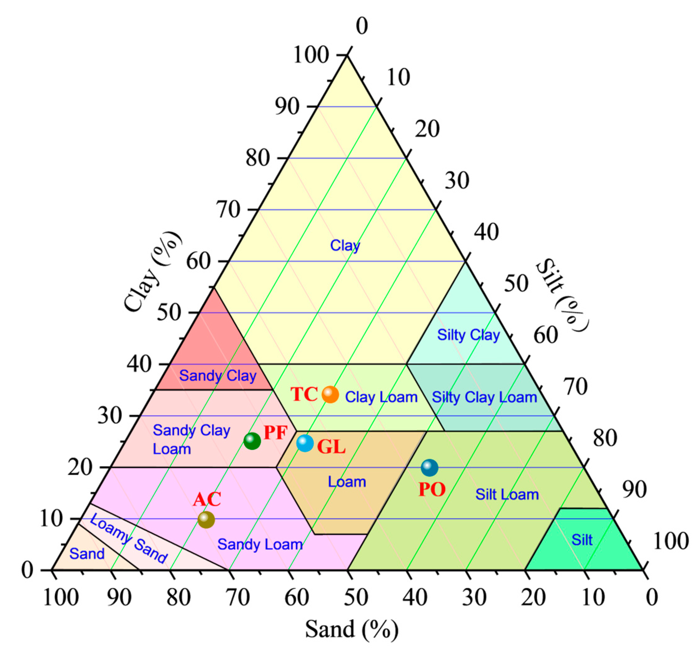
Figure 1. Study area and the location of the experimental sites. (Left) the location of the study area; (Middle) the positions of field experiment sites; (Right) scene of plots of five land use types.
Water 15 03036 g001
Figure 2. Soil column sampling (a) and procedures of CT scanning image processing (b).
Water 15 03036 g002
Figure 3. The soil texture for five experimental sites of different land use types. TC: traditional corn; PO: plum orchard; PF: pine forest; GL: grassland; AC: abandoned cropland.
Water 15 03036 g003
Figure 4. Seasonal variation in macroporosity distribution along the ROI depth. TC: traditional corn; PO: plum orchard; PF: pine forest; GL: grassland; AC: abandoned cropland.
Water 15 03036 g004
Figure 5. Variation characteristics of hydraulic conductivity in different land uses. TC: traditional corn; PO: plum orchard; PF: pine forest; GL: grassland; AC: abandoned cropland.
Water 15 03036 g005
Figure 6. Correlation analysis between soil hydraulic conductivity and soil properties. Note: MWD: mean weight diameter; WSA0.25: percentage content of water-stable aggregates greater than 0.25; SOM: soil organic matter; BD: bulk density; MP: macroporosity; MD: mean diameter of macropore; HD: hydraulic radius; Γ: global connectivity; CP: compactness; K(h): hydraulic conductivity; CI: cumulative infiltration.
Water 15 03036 g006
Figure 7. Factor loading and eigenvalues of extracted components using PCA.
Water 15 03036 g007
Table 1. Typical soil profile data in the study area.
Soil Layers
A (0–15 cm)B (15–53 cm)C (53–100 cm)
Particle size0.05–2 mm45.71%44.74%42.73%
0.002–0.05 mm37.58%36.97%35.87%
<0.002 mm16.71%18.29%21.4%
Soil texture (USDA)LoamLoamLoam
Soil organic matter (g/kg)14.618.414.9
Table 2. Basic characteristics of different land uses.
Land UseFeature Description
TCCorn sowed continuously with a row spacing of 30 cm × 50 cm at the beginning of the rainy season, harvested in October, and plowed and aired in December to prepare for sowing corn the next year.
POTree age is approximately 3 years old, which is typical for fruit orchards in the local area. Tree height and crown width are 1.5–1.8 m and 2.5–3.0 m, respectively. Row spacing is 3 m × 3 m.
PFTree age is nearly 60 years, canopy density is 60–75%, tree height is 9–12 m, and DBH is 11–16 cm. Accompanied by shrubs and herbs.
GLNumerous drought-tolerant perennial herbs clustered on the surface covering approximately 95%. Height of 16.5 ± 5.5 cm.
ACMainly corn planted prior to abandonment. Now, all tilling has stopped. Most herbs are annual and grow randomly.
Notes: TC: traditional corn; PO: plum orchard; PF: pine forest; GL: grassland; AC: abandoned cropland.
Table 3. Basic soil properties under different land use types.
Land
Use
Rainy Season Dry Season
MWD
(mm)
SOM (g/kg)WSA0.25
(%)
BD
(g/cm3)
MWD
(mm)
SOM
(g/kg)
WSA0.25
(%)
BD
(g/cm3)
TC2.05 bc14.73 b63.89 bc1.28 a3.60 ab15.73 b76.85 a1.32 a
PO1.03 d19.65 b55.36 c1.30 a1.45 c20.52 a61.73 b1.29 a
PF3.43 a22.44 a81.37 a1.34 a3.98 a22.46 a83.87 a1.33 a
GL2.89 ab20.02 a82.56 a1.28 a3.00 ab19.93 a82.32 a1.30 a
AC1.98 c16.33 b68.28 b1.31 a2.24 b14.52 b68.18 b1.32 a
average2.2818.6370.291.302.8518.6374.591.31
Notes: TC: traditional corn; PO: plum orchard; PF: pine forest; GL: grassland; AC: abandoned cropland; MWD: mean weight diameter; WSA0.25: percentage content of water-stable aggregates greater than 0.25; SOM: soil organic matter; BD: bulk density. Different letters indicate significant differences within each column at the p < 0.05 level.
Table 4. Soil macropore structure characteristics under different land uses.
SeasonLand UseMP
(%)
MD
(mm)
ΓHD
(mm)
CP
Rainy seasonTC4.75 c2.44 a0.24 b c0.37 ab214.5 b
PO2.62 d2.39 a0.14 c0.32 b96.67 c
PF10.71 a3.11 a0.71 a0.44 a341.46 a
GL7.29 b2.48 a0.36 b0.36 ab163.67 b c
AC2.82 d2.20 a0.09 c0.31 b74.82 c
Average5.642.520.310.36178.22
Dry seasonTC3.94 c2.39 a0.12 b0.33 a173.39 b
PO2.13 d2.34 a0.15 b0.33 a83.89 c
PF8.74 a2.51 a0.47 a0.38 a285.51 a
GL4.82 b1.91 b0.27 b0.22 a114.73 b c
AC1.68 d1.77 b0.04 c0.25 a72.15 c
Average4.432.180.230.30145.93
Notes: TC: traditional corn; PO: plum orchard; PF: pine forest; GL: grassland; AC: abandoned cropland; MP: macroporosity; MD: mean diameter of macropore; Γ: global connectivity; HD: hydraulic radius; CP: compactness. Different letters indicate significant differences within each column at the p < 0.05 level.
Table 5. Eigenvalues and variance of the first three PCA components.
ItemInitial EigenvaluePercent of
Variation (%)
Cumulative Percent
of Variation (%)
Component 16.1651.3251.32
Component 22.7422.8074.12
Component 31.5412.8586.97
Disclaimer/Publisher’s Note: The statements, opinions and data contained in all publications are solely those of the individual author(s) and contributor(s) and not of MDPI and/or the editor(s). MDPI and/or the editor(s) disclaim responsibility for any injury to people or property resulting from any ideas, methods, instructions or products referred to in the content.

