Article

Monitoring, Modeling and Planning Best Management Practices (BMPs) in the Atwood and Tappan Lake Watersheds with Stakeholders Engagements

Civil, and Environmental Engineering, Youngstown State University, One University Plaza, Youngstown, OH 44555, USA
*
Author to whom correspondence should be addressed.
Water 2023, 15(17), 3028; https://doi.org/10.3390/w15173028
Submission received: 9 July 2023 / Revised: 13 August 2023 / Accepted: 16 August 2023 / Published: 23 August 2023
(This article belongs to the Special Issue Water Quality Modeling and Monitoring II)

Abstract

:
This study was conducted in the Atwood and Tappan Lakes watersheds of the Tuscarawas basin of Ohio. The flow, total nitrogen (TN), and total phosphorus (TP) loadings were monitored with the help of local stakeholders for a few years at various locations of the watershed to develop the Soil and Water Assessment Tool (SWAT). The multi-site SWAT model calibration and validation were accomplished with a reasonable model performance. In the next step, the scenario analysis was conducted in the SWAT model using various BMPs, including vegetative filter strips, grass waterways, fertilizer reduction, crop rotation, and cover crops to evaluate their performance in reducing TN and TP from the watershed. While BMPS in many studies are decided based on researchers’ intuition, these BMPs were selected based on active consultation with the local stakeholders, who were engaged in the reduction of TN and TP loadings from the watersheds. Since the SWAT model calibration for TN and TP was not as good as the hydrologic model calibration, various scenarios of TN and TP reduction using BMPs were investigated for several years using both calibrated and uncalibrated SWAT models. We examined all the BMPs in 12 sub-watersheds of the Atwood and 10 sub-watersheds of the Tappan Lake watershed. The analysis indicated that the management practices of cover crops (rye) in combination with grass waterways with a 10% fertilizer reduction could minimize the TN and TP loading by as much as 88%, without significantly compromising the agricultural yield. However, a 10% fertilizer reduction without any BMPs could reduce TN and TP by just 9%. The cover crop (rye) including 10% fertilizer reduction with grass waterways seemed to be the most effective in reducing TN and TP, whereas the implementation of a filter strip led to a 70% reduction and was the next effective BMPs in reducing TN and TP loadings. In general, TN losses were reduced by 8% to 53%, while TP losses were reduced by 7% to 88%, depending on the BMPs used. By and large, the TN and TP reduction achieved through the calibrated model was not significantly different from the uncalibrated model, even though the reduction using the calibrated model was slightly higher for all scenarios than that of the uncalibrated model. The TN and TP loadings were highly sensitive to cattle grazing. When just 50% of the cattle were permitted to graze, the model predicted that there would be a 40% increase in total nitrogen and a 70% increase in total phosphorus in both watersheds. Our investigation revealed that monitoring the watershed at a small sub-watershed scale and calibrating the SWAT model for nitrogen and phosphorus is delicate.

1. Introduction

Water quality problems due to total nitrogen (TN) and total phosphorus (TP) have become increasingly critical over the past few decades as a result of anthropogenic influences including point and non-point sources [1,2,3,4,5] resulting in serious water quality issues in lakes and reservoirs [6,7]. Several past studies reported that non-point sources from agricultural activities [8,9], especially due to the nutrient loading from the agricultural field, is one of the major contributors to water contamination in the United States [10,11,12]. Since farmers generally tend to increase fertilizer input in the field for high agricultural production [13,14,15], excessive use of fertilizers enriched with nitrogen (N) and phosphorus (P) has increased the amount of nutrients discharged into water bodies, thus degrading the quality of lakes and ponds [16,17,18,19].
The alarming rate of TN and TP loading entering water bodies has posed critical challenges, notably the escalating issue of eutrophication in lakes, compromising the quality of drinking water and impacting various water-related activities [20,21,22]. In order to minimize the adverse effects of nutrient pollution in water bodies, many researchers in recent studies suggested that conservation methods, also known as Best Management Practices (BMPs), including vegetative filter strips (VFS), grass waterways (GWW), fertilizer reduction (FR), crop rotation (CR), and cover crop (CC) have been widely recommended as viable mitigation measures to reduce non-point pollution and improve water quality in impaired waterbodies [23,24,25]. However, the efficacy of BMPs is case by case and mostly limited to site-specific locations. As a result, there have not been any standardized or widely approved BMPs coherent for all types of case studies [26,27,28].
Even though field experiments are ideal for assessing the effectiveness of these BMPs for a particular site, field experiments, especially on a small scale, are not feasible because of their high cost and lengthy duration [29]. One of the typical approaches to address this issue is to use a watershed model and evaluate the appropriate BMPs for the specific study. Numerous studies conducted in recent decades have investigated the effectiveness of BMPs in water quality analysis [11,30,31,32] utilizing the watershed model Soil and Water Assessment Tool (SWAT). For example, several studies reported that VFS could potentially reduce the nutrient level by 31% to 90% [33,34]. Additionally, several investigations have demonstrated that crop rotation can lead to a significant decrease in nutrient load, with reductions ranging from 15% to 32% [7,25,35]. The application of cover crops has been proven to be effective to decrease nitrogen and phosphorus by 20% to 38% [36,37]. Furthermore, research by various scientists reported that GWW could reduce nutrient concentration by 17% [38]. However, many researchers point out that addressing nutrient pollution by employing BMPs is still complex and faces immense challenges [27,39,40] partly because many BMPs are either simply not sustainable due to site conditions, and mainly because the farmers and local stakeholders have strong reservations about the implementation of such BMPs due to maintenance issues in the long run. In this context, consultation with watershed stakeholders, for instance, watershed specialists and local farmers of the study area, is crucial for the application of sustainable BMPs in the field. The models developed using the data from field monitoring along with the direct involvement of stakeholders [41] can be helpful in better understanding the water and nutrient transport processes [42,43]. Besides modeling, active stakeholder engagement from the onset of project design is equally important for sustainable water quality management to integrate the stakeholder’s perceptions of water quality problems, indigenous knowledge, expertise, and rights in the decision-making process [44,45,46]. Though several scientific tools and approaches for BMPs have been developed, very few of them are sustainable for the benefit of the community. Therefore, this study will involve coordination with various stakeholders, including agencies engaged in water quality monitoring, to obtain their potential suggestions for SWAT model development. One of the new approaches of this study is to coordinate with stakeholders in water quality monitoring and take their feedback in model development.
In summary, the major objectives of this study are to: (i) monitor the watershed, collect the sample, and analyze the TN and TP for SWAT model development; (ii) calibrate the model for flow, TN, and TP to develop various scenarios of potential TN and TP reduction in the Atwood and Tappan Lakes from the sub-watersheds using the BMPs suggested by the stakeholders.

2. Materials and Methods

2.1. Study Area

The study was conducted in the Atwood and Tappan Lake watersheds located within the Tuscarawas basin, which is geographically positioned in the northeast part of Ohio (Figure 1). The Atwood Lake watershed encompasses 181 km2, whereas the Tappan Lake watershed covers 183 km2. Both watersheds, with elevations ranging from 256 to 415 m, drain into their respective lakes and receive 1085 mm of precipitation per year. In general, each watershed is dominated by forest accounting for more than 50% of the entire watershed area. Atwood and Tappan share similar watershed characteristics in terms of land use and land cover. For example, the Atwood and Tappan watersheds are characterized by approximately 30% and 20% of agricultural land including pasture, respectively (Figure 1). These land uses are considered major sources of non-point source pollution. Though the portion of agricultural/hay area is relatively less, both lakes experience water quality impairment, including eutrophication and algal bloom. Tappan Lake provides drinking water to the town of Cadiz, while Atwood Lake serves only a small portion of Carroll County.

2.2. Soil and Water Assessment Tool (SWAT)

Globally, SWAT is one of the widely used semi-distributed watershed models to assess the impact of management practices on analyzing water quantity and quality [47,48,49]. The model is popularly used for the simulation of hydrologic analysis, erosion, nutrient cycle, and pesticide transport [50,51] in small to very large complex watersheds with varied soil and land use characteristics across the world [52,53,54].
There are typically two phases of the hydrological cycle represented in the SWAT model, including the land phase and the routing of runoff through the reaches. When simulating the land phase of a river’s flow, researchers divide the basin into smaller sections called “sub-basins,” each of which has its own unique set of land use/land cover, soil type, and slope. The water balance is then determined for additional Hydrologic Response Units (HRUs) in each sub-basin. During the routing phase, control points decide how water will flow through the stream network and discharge from the basin outlet, connecting the many sub-basin outlets [55].

2.3. SWAT Model Input

The simulation of stream flows involves inputs including digital elevation model (DEM), land use, soil, weather, etc. (Table 1). The stream networks were delineated in ArcGIS using a digital elevation model (DEM) of 30 m resolution, which was downloaded from the USGS National Elevation Dataset. This resulted in the creation of 46 subbasins following the demarcation of the watershed boundary. Moreover, the most recent land use data with a resolution of 30 m was obtained from the National Land Cover Database to appropriately represent the existing land use characteristics of the watershed. The high-resolution soil data from Soil Survey Geographic Database (SSURGO) was used as the input for the SWAT model. Since a large number of HRUS are extremely helpful for streamflow prediction [56], 761 HRUs were created after excluding the minor land uses, soils, and slopes using a threshold of 10%, 10%, and 5%, respectively.
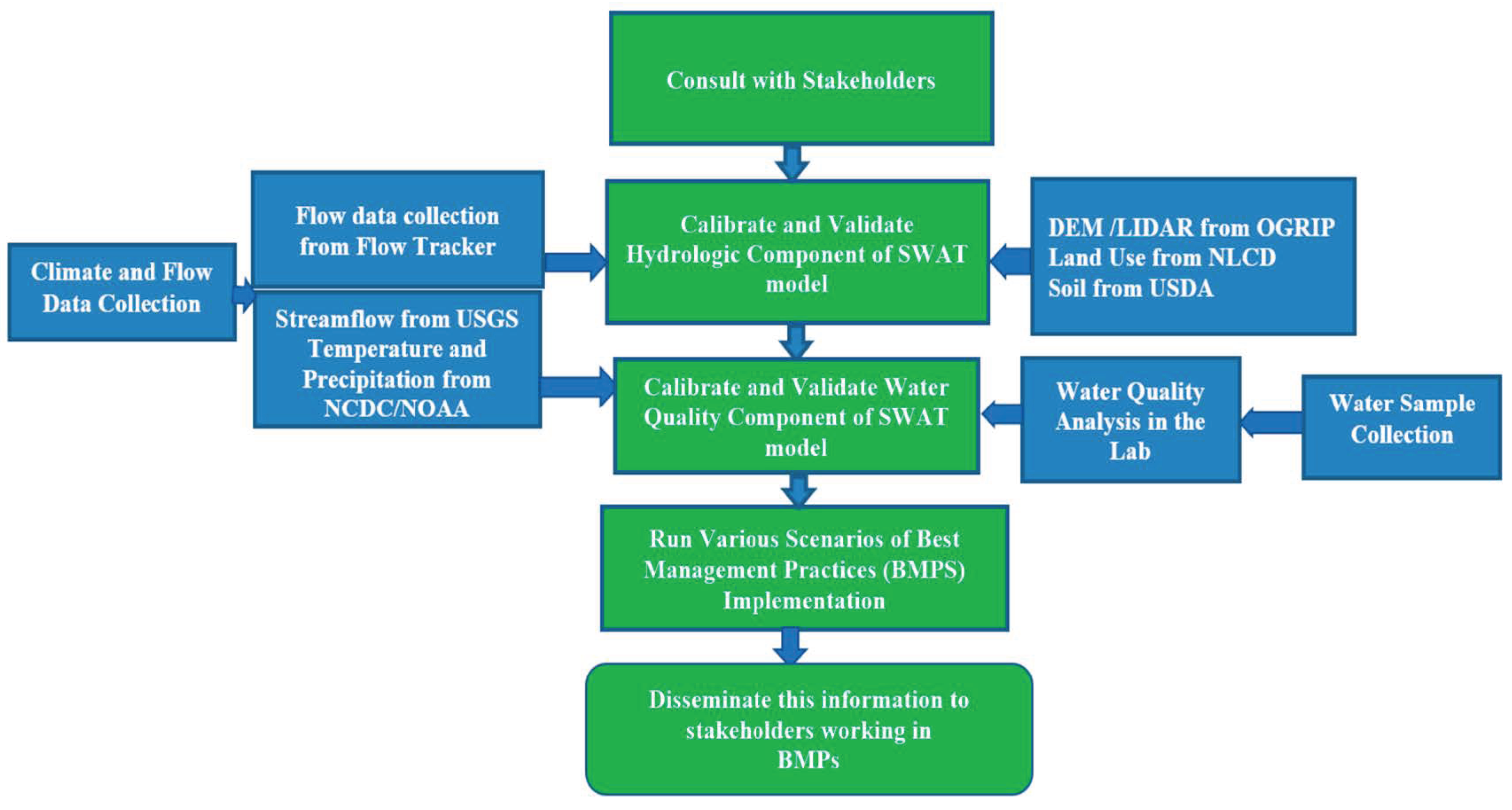
The climate data over the past 20 years were obtained from the National Climatic Data Center (NCDC) in order to capture the spatial and temporal variability of the precipitation and temperatures as recommended by various studies [57,58]. Altogether, four precipitation and temperature stations were incorporated into the model, and the remaining climatic datasets were simulated using the SWAT built-in weather generator. Additionally, five USGS locations were used to obtain the daily flow data to accomplish multi-site calibration and validation of the stream flow. The flow chart for the entire methodology is presented in Figure 2.

2.4. Model Calibration and Validation

The application of distributed watershed models as decision-making tools in the field of water management is increasing [59]. Therefore, it is essential that these models undergo a comprehensive process of calibration and validation [60]. For this, the model was set up to calibrate and validate at multiple sites by using the SUFI-2 algorithm in SWAT Calibration and Uncertainty Program (SWAT-CUP) [61,62,63].
The SWAT model was set up from 2000 through to 2020 and run in monthly time steps after an initial 3-year warm-up period (2000–2002). Thirteen years of observed streamflow data from 2003 to 2015 at three USGS sites within the Tuscarawas watershed were used for model calibration. The SWAT-CUP was utilized to conduct sensitivity analysis to identify the most sensitive model parameters for the hydrologic simulation. Additionally, manual calibration was also undertaken following the automatic calibration to adjust the model parameters. Twenty distinct model parameters were selected for hydrological calibration (not shown) based on previous studies [53]. In the next step, the optimized model parameters were tested against the observed streamflow data from 2016 to 2020 at each site for validation using various statistical measures to evaluate the performance of the model including coefficient of determination (R2), Nash—Sutcliffe efficiency (NSE) [64], percent of bias (PBIAS), and root mean square error (RSR).

2.5. Hydrologic and Water Quality Monitoring

Since long-term and spatially distributed hydrologic and water quality data are essential for simulation studies, monitoring sites were established at various locations on the Atwood and Tappan Lake sub-watersheds. The five stations (Figure 1) were identified by consulting with the stakeholders of Carroll and Harrison Counties, which generally represent the upstream sub-watersheds. The water samples were collected using the grab sampling method at the five stations and sent to the water quality laboratory for the analysis of total nitrogen and total phosphorus concentrations. Meanwhile, stream flow data were also recorded on those stations with the help of Flow Tracker 2, which was specifically used to log the flow data at small shallow creeks.
The water quality monitoring plan [65] was adopted during the collection and analysis of water samples, whereas the EPA protocol was followed for water sample collection and delivery to the laboratory. For example, a sample bottle was rinsed three times before collecting a water sample, and then the sample was preserved with 2 mL sulfuric acid (H2SO4). Then, the samples were stored in an ice box to maintain the temperature below six degrees for laboratory analysis of total nitrogen and total phosphorus.
Since the nitrogen and phosphorus data were sporadically collected from 2015 to 2022, on average, 15 observed data were recorded for each designated monitoring station. Particularly for TN and TP simulation, we chose a manual calibration helper in the SWAT model using available observed nitrogen and phosphorus data. The most sensitive parameters (not shown) which were identified through similar studies conducted in different regions were considered in the SWAT model [8]. Since it is a general practice to use a regression-based Load Estimator (LOADEST), a software developed by USGS to generate continuous data from sporadic sets of data [66,67], this study utilized the LOADEST to interpolate observed nitrogen and phosphorus data at the five monitoring stations to generate continuous data in daily and monthly scales.

2.6. Best Management Practices Scenarios

In order to analyze the effectiveness of the BMPs on reducing nutrient pollution, such as vegetative filter strip (VFS), grass waterways (GWW), crop rotation (CR), cover crop (CC), and fertilizer reduction (FR), these BMPs were employed in the agricultural areas of both watersheds in the SWAT model to simulate TN and TP loadings. The efficacy of all BMPs was evaluated in the Atwood and Tappan Lake sub-basins by computing the reduction TN and TP yield at the outlets of respective lakes and comparing it with the baseline scenario (i.e., no BMPs). Furthermore, we evaluated the sensitivity of cattle grazing patterns in the pasture lands of both watersheds, resulting in TN and TP yields.
In this study, VFS of 1 m width were applied only for agricultural and pasture land use, which were identified in both watersheds using ArcGIS. We also experimented with a 7 m width VFS, but the agricultural area in both watersheds was relatively small; therefore, we adopted a VFS of 1 m width as a reasonable selection. Similarly, the average width of 3 m and depth of 0.5 m for GWW with other default values of parameters were considered while simulating the GWW in the model. The winter cover crop simulated in this study was rye, which has demonstrated reasonable effectiveness in lowering the nitrogen load from agricultural fields [68]. For this, we discussed with the producers and stakeholders the feasible cover crops (rye) that could potentially be used in the watersheds. The cover crop, rye, was simulated after completing the harvest and kill operation of the major crop.
Next, crop rotation is a universal farming method that lets different crops be grown in the same location at different times [69]. The water quality can be improved by changing the order of cultivation of different crops [7,16,70]. Therefore, corn-soyabean rotation was simulated in alternate years to assess TN and TP yields by consulting with stakeholders.
Likewise, in order to see the impact of TN and TP reduction, the fertilizer application rate was reduced by 10% as one of the BMPs to evaluate the TN and TP reduction and crop yield. The greater amount of TN and TP flow is one of the consequences of over-exploitation of pasture fields by cattle grazing [71,72,73]. In order to analyze the impact of cattle grazing on TN and TP yields from pasture lands, the population of cattle, grass consumption, and manure deposition were estimated based on various reports [74,75]. Since it was not possible to exactly determine the number of cattle grazing in the field in the given month, sensitivity analysis was conducted in TN and TP yield using the percentage of cattle (25%, 50%, and 100%) in the watershed possibly engaged in grazing.
Simulations were carried out over a span of several years, from 2000 to 2022, in order to better realize the effects of climate variability on the implementation of best management practices (BMPs). These simulations were conducted at intervals every seven years and compiled, which included a warm-up period of two years for each simulation. This approach of the short and equal interval of running the model was adopted to ensure that the model could produce coherent and consistent analysis for BMP implementation on the SWAT model.

3. Results and Discussion

3.1. Model Calibration

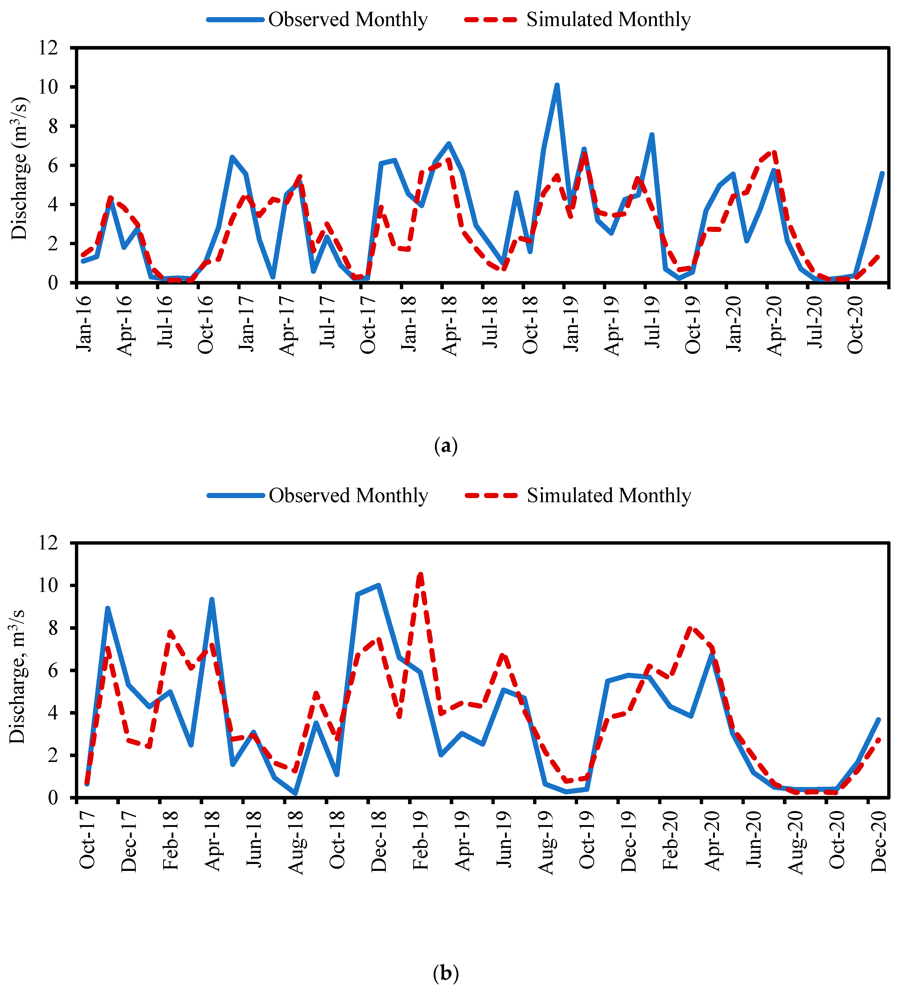
The graphical representation and statistical criteria exhibited satisfactory SWAT model performance during calibration and validation (Figure 3). The statistical parameters NSE, R2, PBIAS, and RSR that measure the monthly performance of the model are tabulated in Table 2. The NSE values ranged from 0.54 to 0.79 for monthly streamflow calibration, and from 0.50 to 0.89 for monthly streamflow validation at USGS gauge stations, which is considered good [64]. The sub-watershed response in terms of flow was consistent with the overall flow from the final outlet of the entire basin. The performance of the model for the sub-basins representing the Atwood watershed (lake outlet) and Tappan watersheds (lake outlet) show satisfactory results, though not as good as the other three stations, which were used in model calibration because the observed time series discharge of those lake outlets was limited (Figure 4). However, we experimented with various precipitation data from the stations located within the watershed boundaries and beyond to ensure that the precipitation data were more or less consistent with the observed streamflow. Our analysis suggested that the precipitation data utilized in our model analysis appropriately represented the corresponding observed streamflow of respective locations (lake outlets).

3.2. Water Quality Calibration

The graphical representation of the simulation of water quality analysis for the baseline was compared with the monitored nutrient data (Figure 5) for five different stations. However, a single station is presented in Figure 6 for the conciseness of the manuscript. The nutrient calibration in the present study was relatively less satisfactory as compared to the hydrological model calibration. This can be attributed to the fact that the available sporadic data pertaining to nutrient concentrations were limited in number, and only a few of these data sets were encompassed by the simulated datasets. The correlation between observed concentrations and simulated concentrations for five monitoring stations was compared to observe the performance of the calibrated model in predicting nutrient flow.
It is noteworthy to report that the calibration of the model for TN and TP was accomplished upstream of the lake, where the hydrodynamic influence of the lake was not experienced. This is because the SWAT model does not simulate the lake nutrient processes, and the calibration of the nutrient at the outlet is not justified unless we couple it with hydrodynamic and water quality models.
In addition, continuous daily total nitrogen and total phosphorus load (kg/d) from 2015 to 2022 was estimated with the LOADEST. In the next step, after converting the daily load to the average monthly, the estimated monthly average load was compared with the load simulated using the SWAT model. The graphical representation of the comparison is depicted in Figure 6 (Station ATW 10). The load distribution pattern appears to be comparable to the LOADEST and SWAT models, despite significant differences in peak load estimations. Specifically, the peak load estimations produced by LOADEST are significantly lower than those produced by the SWAT model except in one station (TAP6). This disparity could be due to several reasons, including a lack of sufficient observed data. One of the reasons for underestimation by the LOADEST regression could be due to the sample primarily being taken during the low and medium flows. We had to rely on our stakeholders to collect the sample and they prefer to avoid sampling when there is heavy rainfall. The water quality sampling during extremely high flows was also not physically possible due to the size of the streams. The LOADEST primarily relies on 10 available regression equations and can decide the best fitting of the observed data with simulated output based on the data pattern. While we experimented with all regression equations in the LOADEST, the regression equation automatically selected by the LOADEST was used for the analysis.

3.3. BMPs Analysis

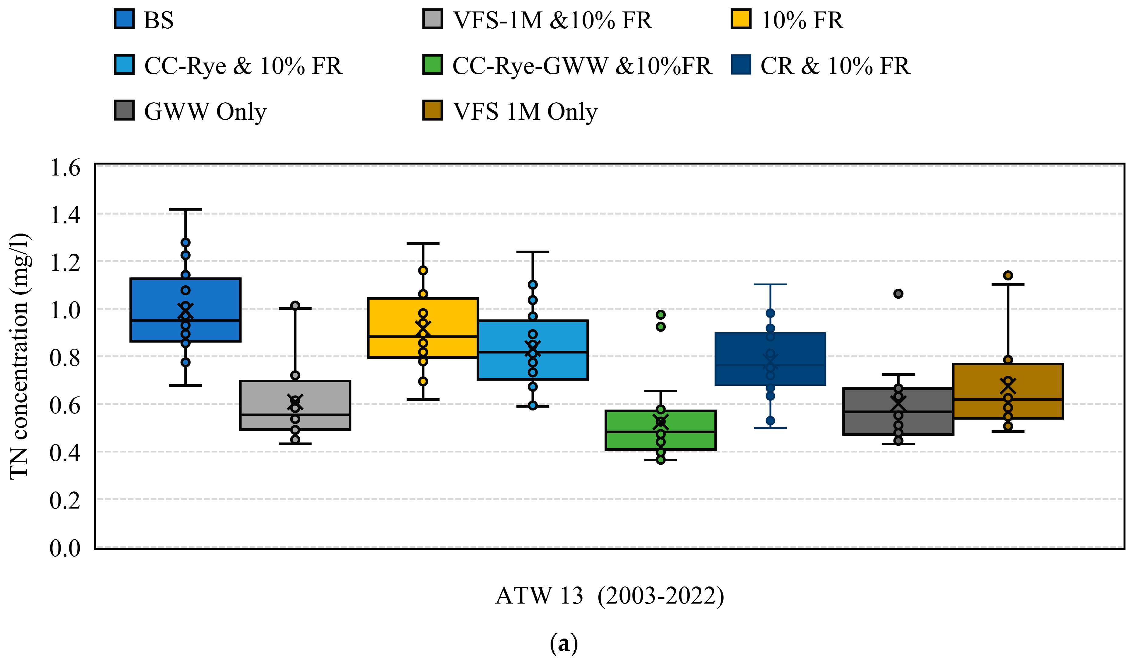
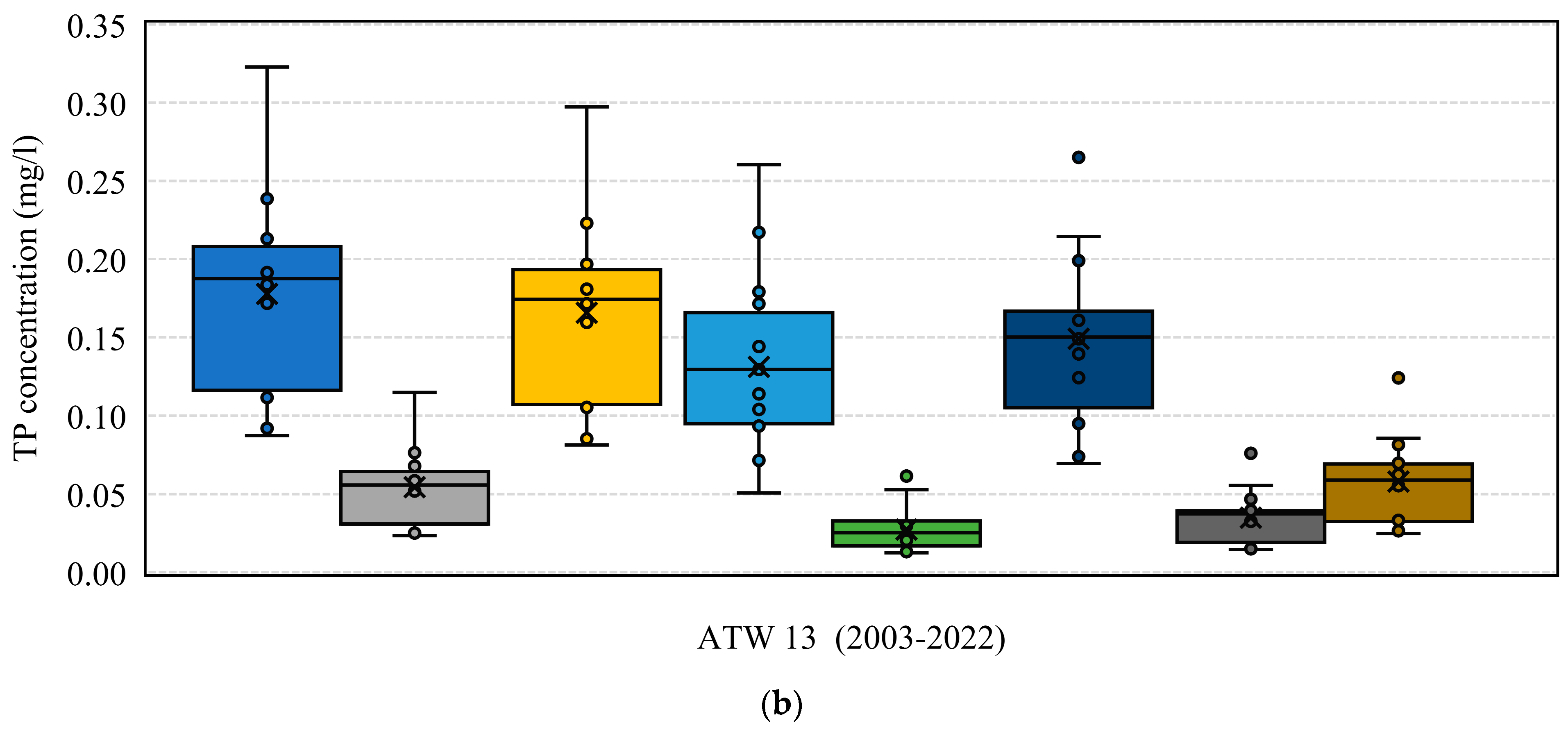
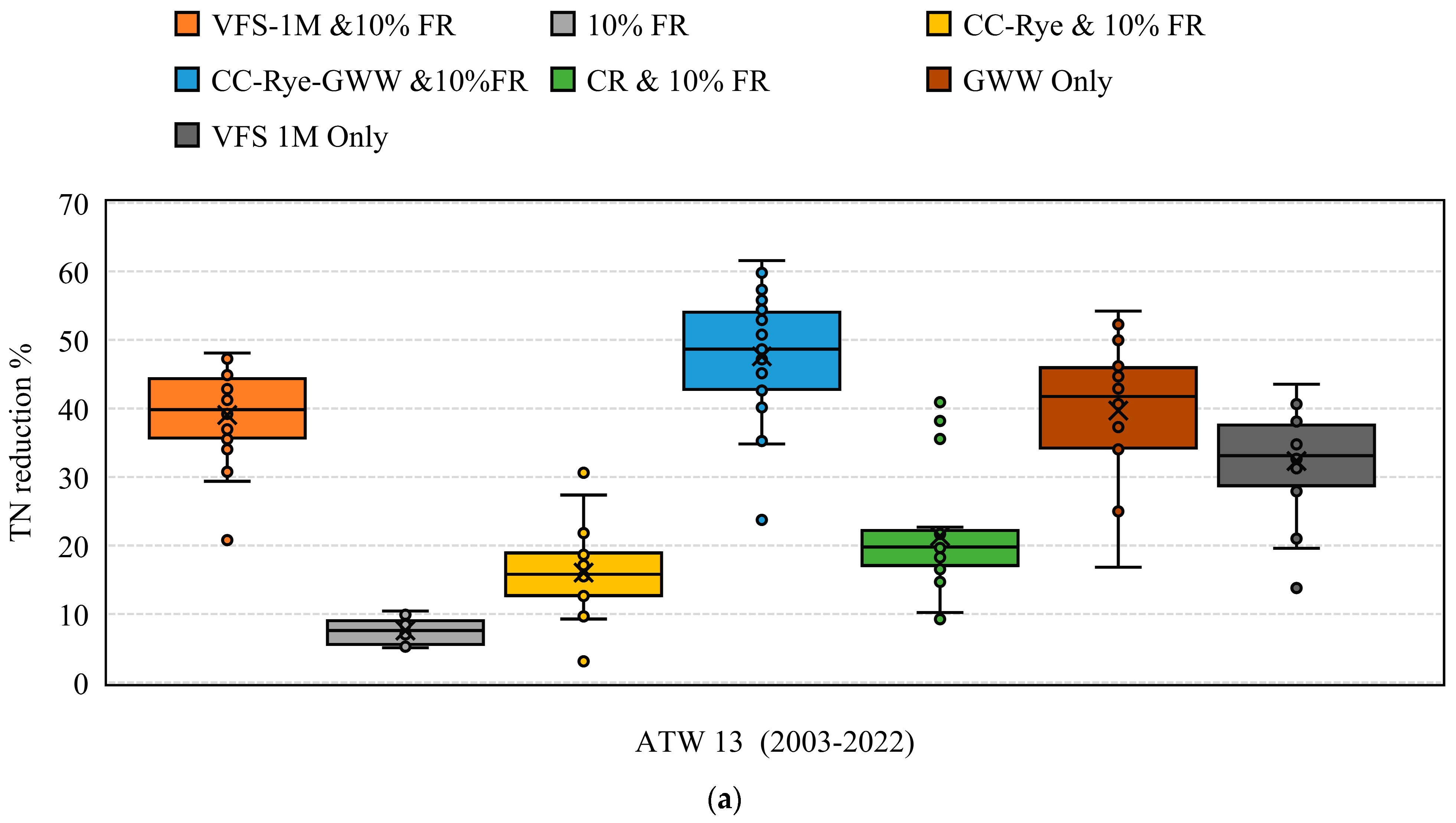
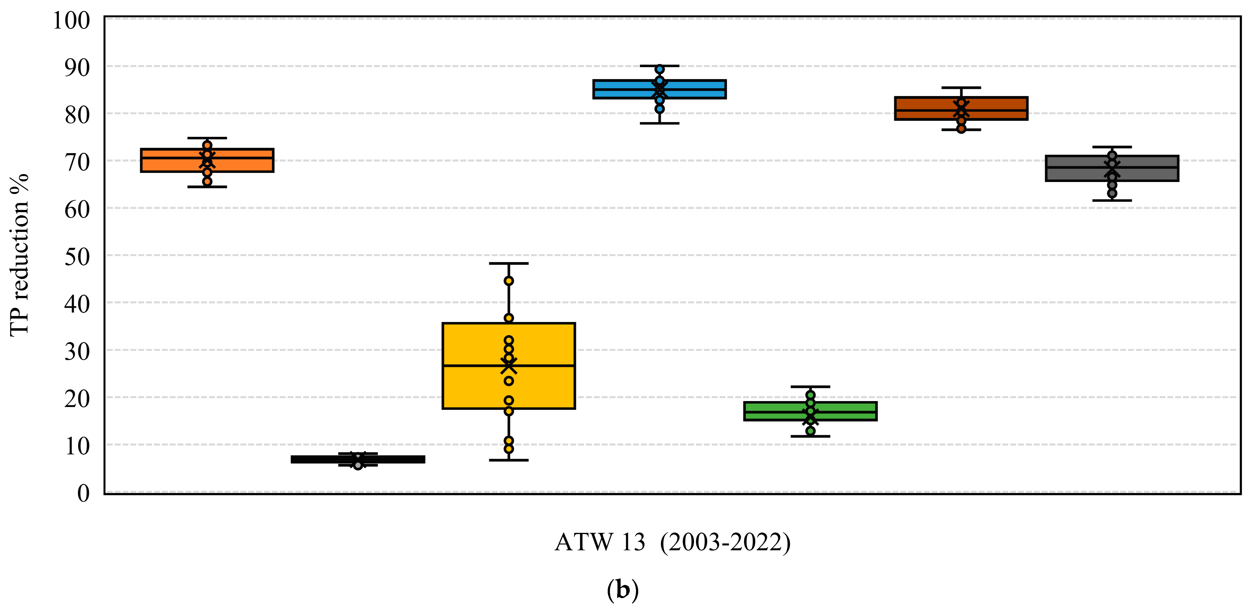
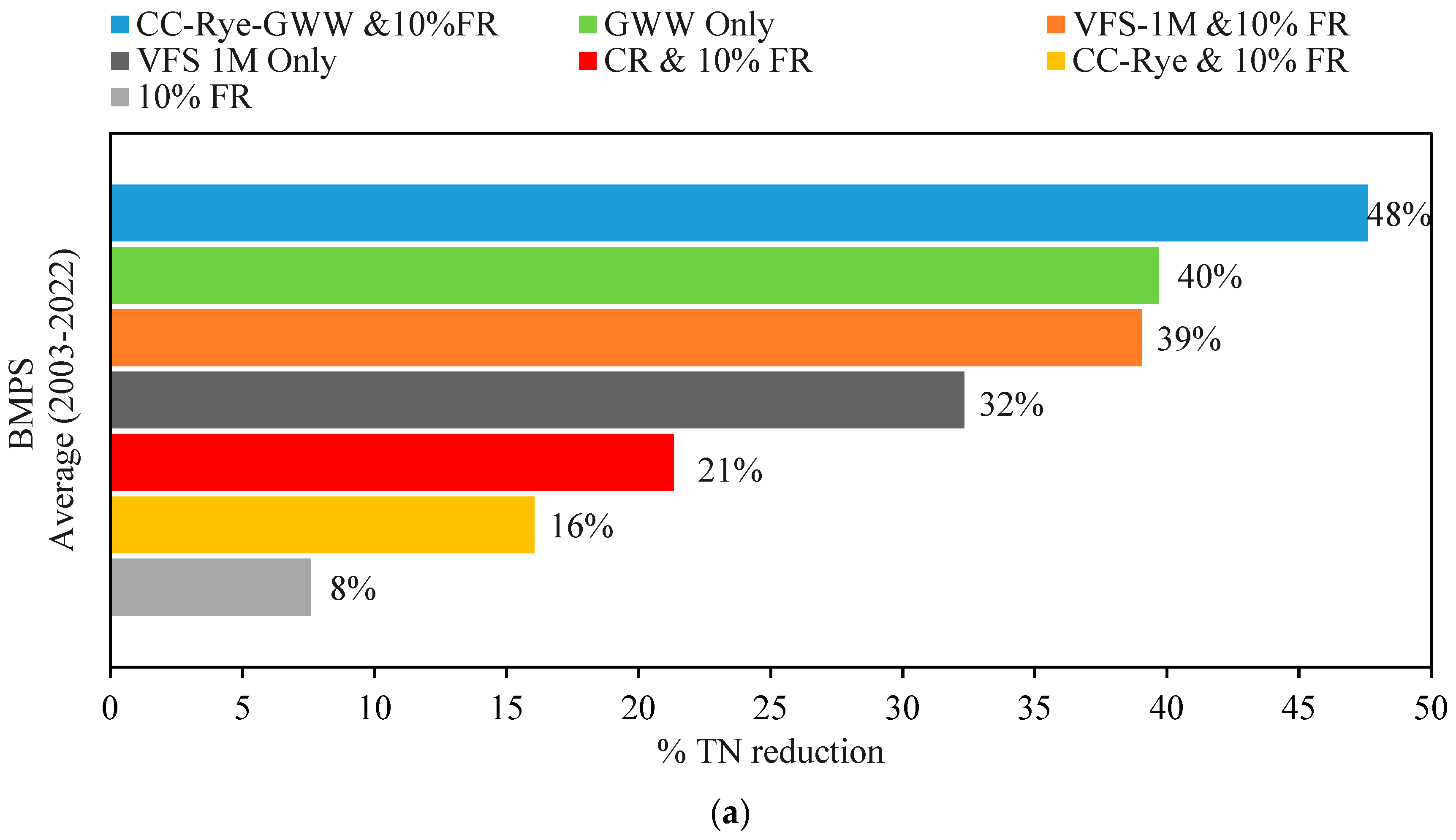
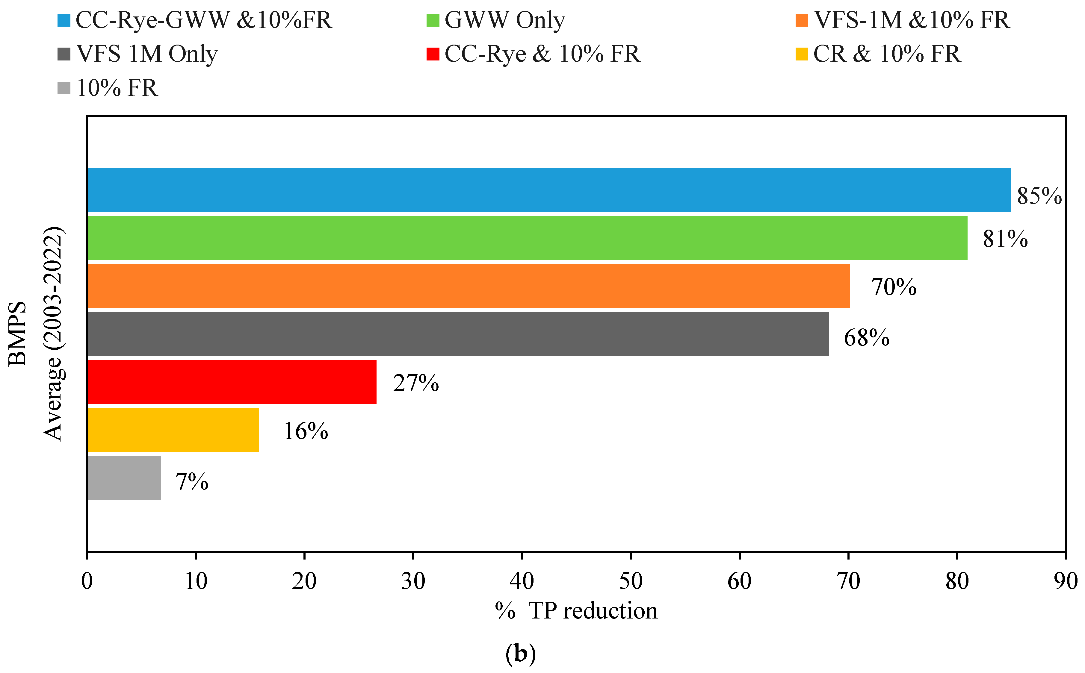
This study used the existing practice of corn cultivation and fertilizer input as baseline scenarios to evaluate operation management strategies. Since the water quality calibration was not as good as the hydrologic calibration, the BMPs were simulated in both calibrated and uncalibrated SWAT models and the results were compared in terms of TN and TP reduction. The analysis conducted in the Atwood watershed showed that each BMPs showed a wide range of variations in TN and TP concentrations in various years in both watersheds (Figure 7). The study found that the modeled BMPs generally have small variability in total phosphorus reduction, except for a scenario in which the cover crop was implemented with a 10% fertilizer reduction (Figure 8). It is worthwhile to report that the yield was significantly reduced when the fertilizer reduction was lowered by more than 10%. Therefore, fertilizer reduction was limited to 10%, which brought a negligible change in crop yield. However, there was some variation among BMPs in terms of their efficacy in reducing total nitrogen and total phosphorus. The average reduction in total nitrogen and total phosphorus from the application of BMPs and their combinations at the outlet of both lakes is presented in Figure 9. The reduction in TN and TP was experimented with each BMP, one at a time, in both watersheds.
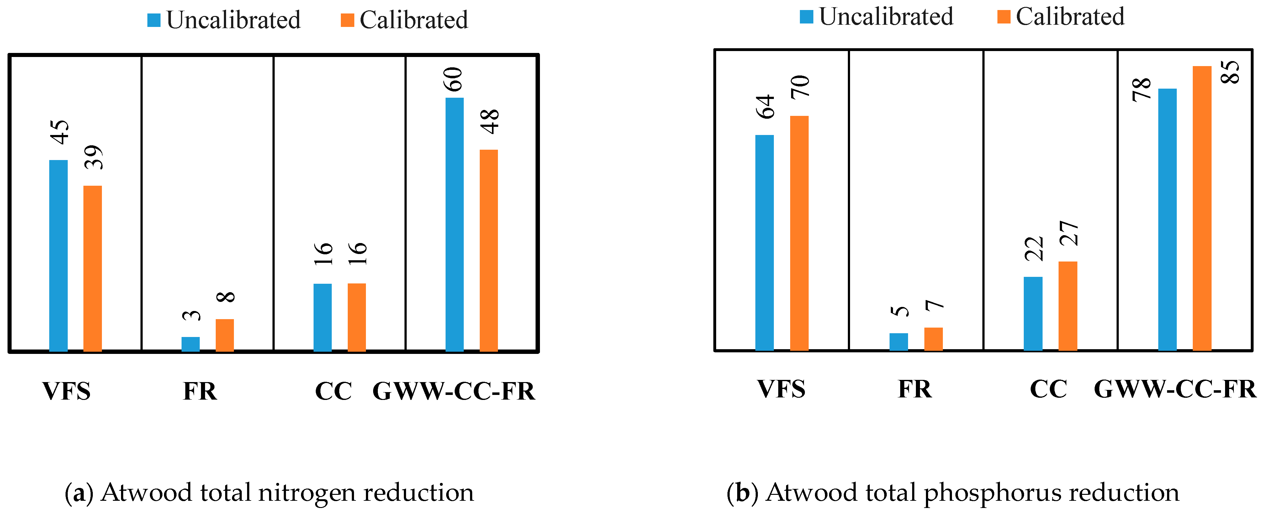
The simulation study conducted in the Atwood watershed using GWW suggested that the reduction of total nitrogen and total phosphorus ought to be 40% and 81%, respectively, at the outlet of the lake. The reduction indicated that the effectiveness of GWW is comparatively higher, and similar findings were also asserted by a previous study [76]. Likewise, VFS exhibited reductions of 32% for both total nitrogen and total phosphorus, which is consistent with earlier studies [77,78]. The total nitrogen and total phosphorus were reduced by 8% and 7%, respectively, with a minor decrease in agricultural yield (1%), when applying a 10% fertilizer reduction. Since rye was a predominately used cover crop, we experimented with the combination of rye, GWW, and 10% fertilizer reduction. It further reduced the total nitrogen and total phosphorus by 48% and 85%, respectively.
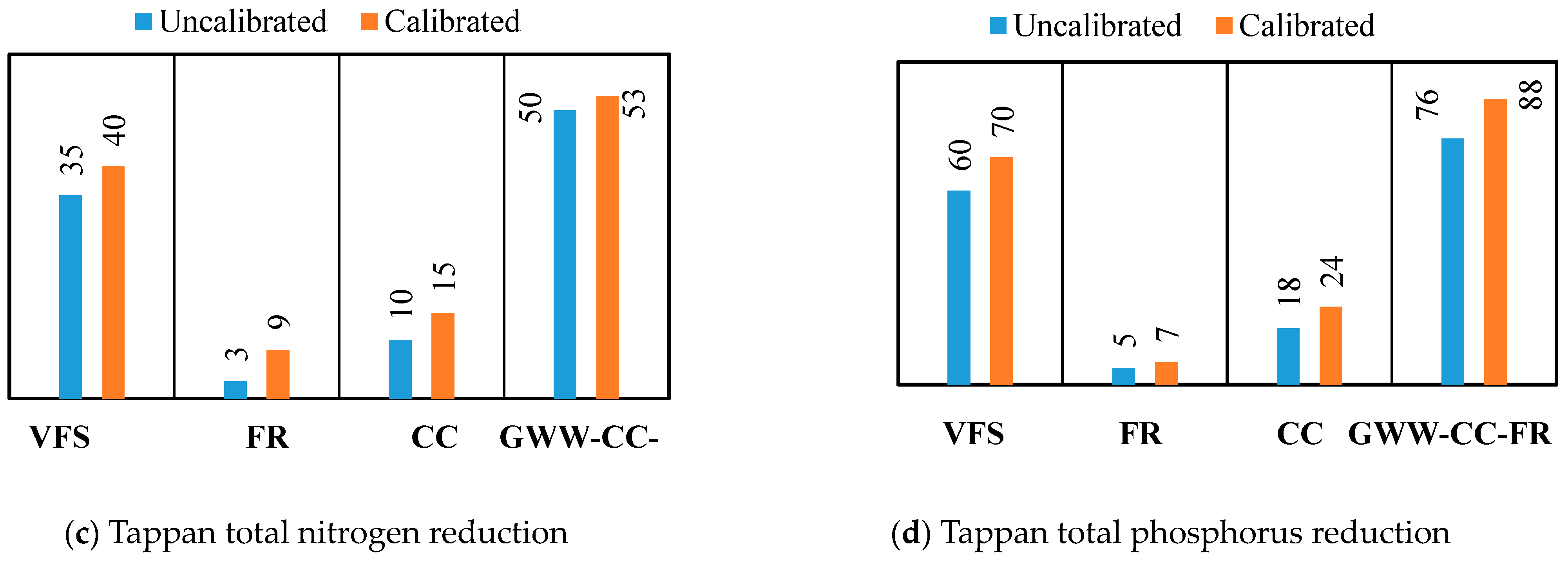
Since both watersheds shared similar land use/land cover characteristics and climatic features, the TN and TP reduction in Tappan watersheds showed similar reductions from BMPs at the outlet of the watershed when compared with a baseline for the entire simulation period of 2000 to 2022 (Figure 10). The analysis conducted in the Tappan watershed suggested that the effectiveness of GWW was significant. The average reduction of total nitrogen in the Tappan watershed was of 46%, whereas total phosphorus was reduced by 86% (Figure 10). In fact, the reduction of total nitrogen from the use of GWW was as low as 22% in 2012, whereas it was as high as 54% in 2004. This is not surprising because the year 2012 was a dry year with a yearly precipitation of 892 mm, whereas the year 2004 was considered a wet year with a yearly precipitation of 1370 mm, and the TN and TP simulation in the SWAT model was primarily driven by the climate as we did not vary the fertilizer application and land use/land cover each year (Figure 11). However, variation in total phosphorus reduction was less sensitive to climatic patterns. Next, a fertilizer reduction of 10% as a standalone BMP was experimented, which lowered the total nitrogen and total phosphorus by 9% and 7%, respectively, in the same simulation period. However, the removal efficiency was not significantly varied in both years, suggesting that this particular BMP is less sensitive to climatic variability. Likewise, the implementation of VFS on average reduced total nitrogen and total phosphorus by 34% and 68%, respectively, for the entire simulation period. This finding of the efficacy of VFS for TN and TP reduction was consistent with many previous studies [34]. In addition, it is interesting to report that the performance of VFS was similar to GWW for total nitrogen reduction, which was as high as 38% in the wet year of 2004 and as low as 17% in the dry year of 2012. The scenario analysis with the combination of rye, GWW, and 10% fertilizer reduction was experimented with in the model, which showed a reduction of total nitrogen and total phosphorus by 53% and 88%, respectively (Figure 12). In addition, the overall analysis of both watersheds demonstrated similar phenomena in TN and TP reduction while simulating the model for the entire simulation period of 2000–2022.
In general, when comparing the individual effect of BMPs in both watersheds, GWW showed the highest average reduction in total nitrogen, ranging from 20% to 53%, while VFS decreased the average total nitrogen load by 16% to 40%. The results indicated that percentage reductions in total nitrogen were sensitive to climatic conditions, as the watershed experienced comparatively low precipitation in 2012 and comparatively high flow in 2004. The effectiveness of GWW in the reduction of average total phosphorus varied from 82% to 87%, while VFS reduced the average total phosphorus load from 67% to 72% during the simulation period. Moreover, the analysis revealed that a fertilizer reduction of 10% reduced the total nitrogen and total phosphorus by 9% and 7%, respectively, throughout the simulation period, with small variability in reduction from year to year. It is crucial to report here that the higher reduction of TN and TP in GWW is not only because of its efficacy but also due to its application in relatively larger areas as the GWW was implemented all in agricultural and pasture areas, which covered almost 25 to 30% of the total watersheds for both Atwood and Tappan. Therefore, the efficacy of each BMPs is location-specific and true only for this particular research, meaning they are not simply transferrable to other locations as the fertilizer reduction could be more effective in a watershed where agricultural land is significant.
On the other hand, BMPs such as fertilizer reduction, cover crop, and crop rotation were not effective for reducing TN and TP as those were limited to agricultural lands, which account for a small percentage of the overall watershed area (approximately 3% for both watersheds), suggesting that the TN and TP reduction from cover crops, fertilizer reduction, and crop rotation might be significant in agriculture-dominant areas. It is important to note that the effectiveness of these practices varies on a case-by-case basis and also depends on various factors including soil type, climate, slope, etc.
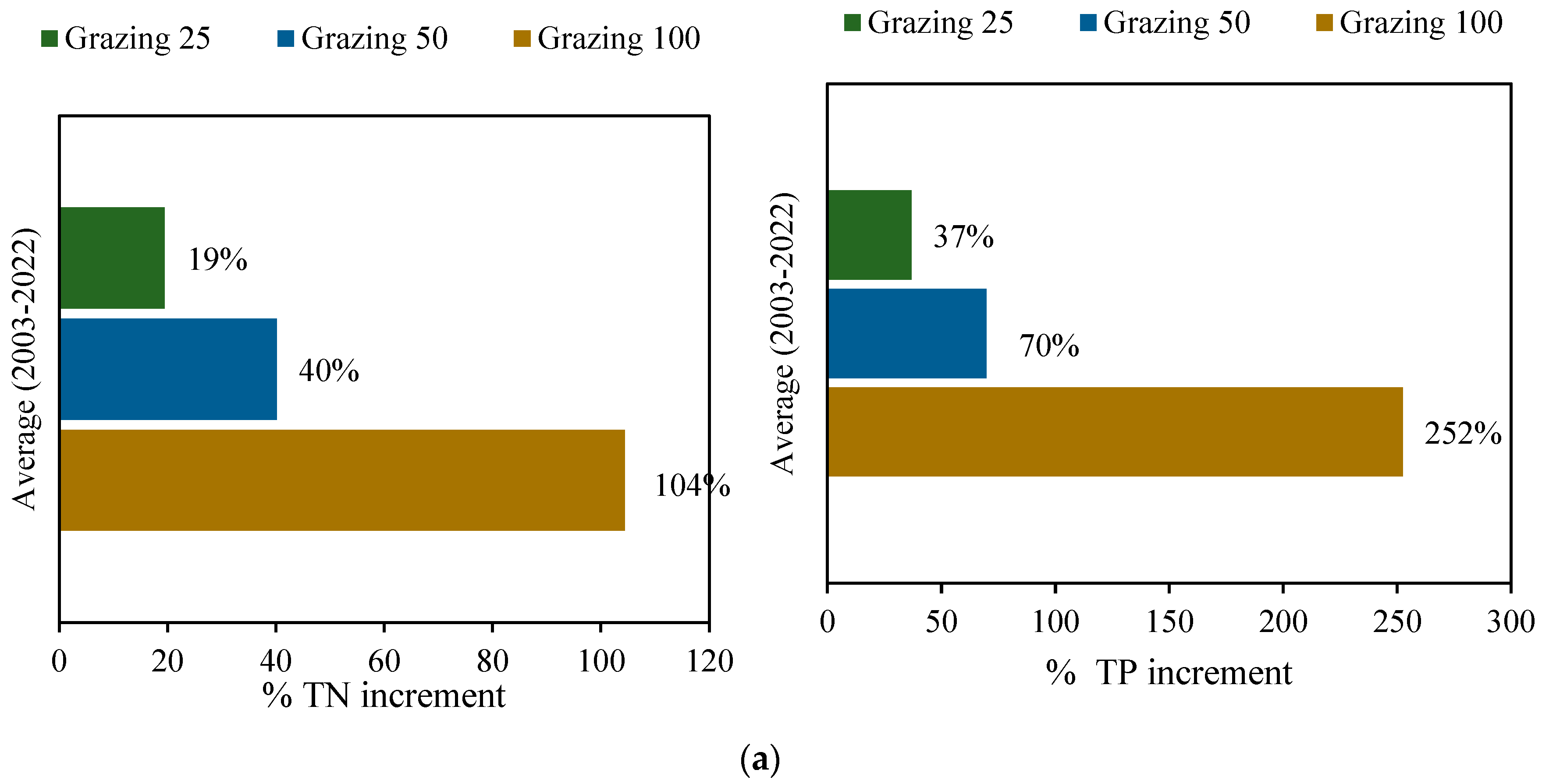
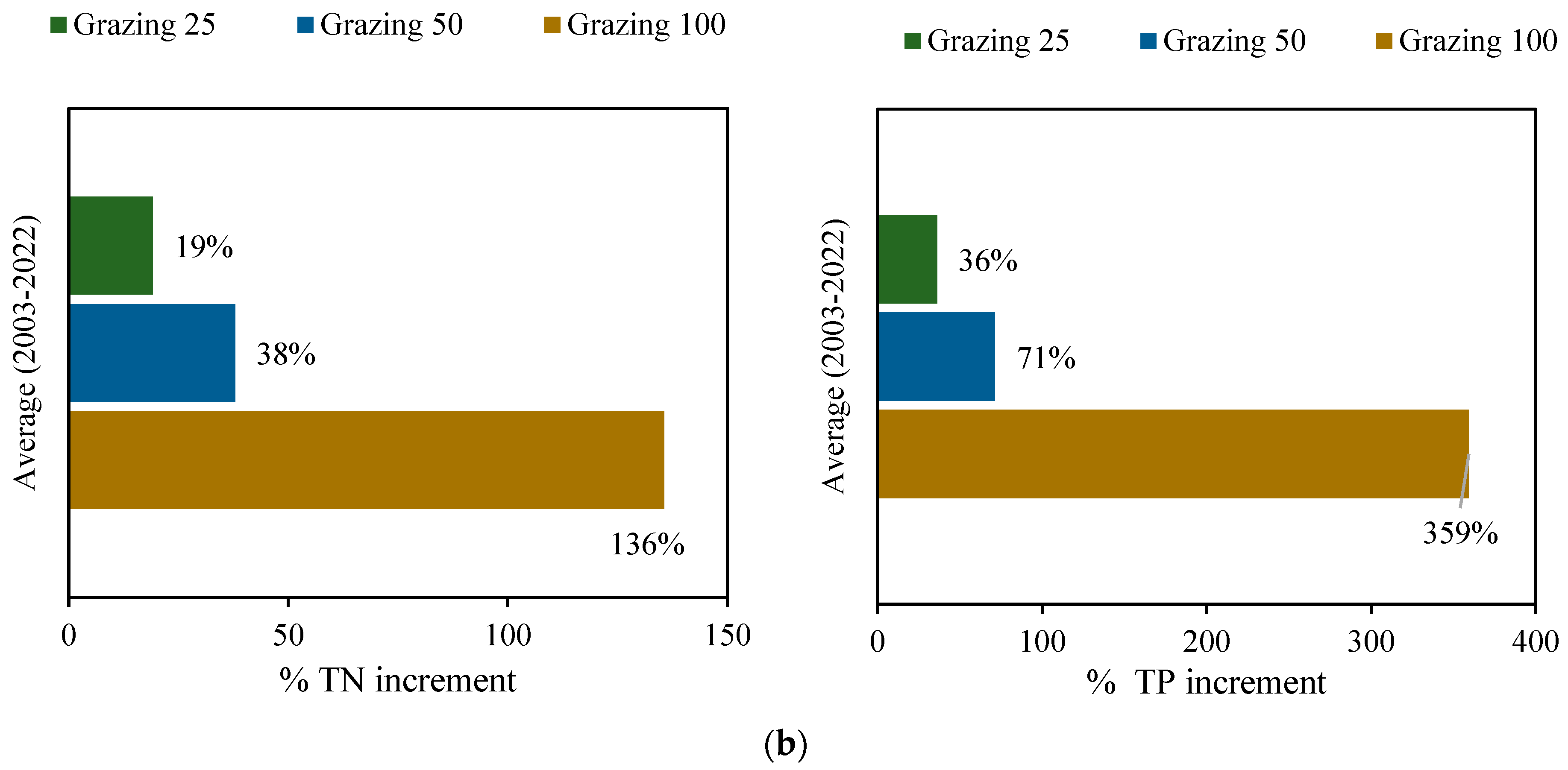
Moreover, the study investigated the sensitivity of cattle grazing on TN and TP loading in the watersheds (Figure 13). The research found that the TN and TP load dramatically increased in both watersheds when all of the cattle were allowed to graze freely in the pasture areas. The Atwood Lake watershed demonstrated an increase in total nitrogen of 100% and total phosphorus of 250%, whereas Tappan Lake watershed demonstrated an increase in total nitrogen and total phosphorus, respectively, of 135% and 350%. When just 50% of the cattle were permitted to graze, the model predicted that there would be a 40% increase in total nitrogen and a 70% increase in total phosphorus in both watersheds. Likewise, when 25% of the cattle were allowed to graze, on average, there was an increase of 19% and 36% in total nitrogen and total phosphorus in both watersheds, respectively. This study suggests that controlling cattle grazing in the pasture area is essential to minimize TN and TP load in both watersheds as noted by previous studies [71,73].
While conducting BMPs analysis, it is worthwhile to report that the results in terms of TN and TP reduction with the uncalibrated model were not considerably different from the calibrated model, even though the TN and TP reduction using the calibrated model was slightly higher than that of the uncalibrated model (Figure 14). The findings of the comparison between the calibrated and uncalibrated SWAT model indicated that the calibration of the model would not have a substantial effect on BMPs analysis when ranking their effectiveness as long as the watershed area and other characteristics remain the same. These findings are in line with previous studies suggesting that the uncalibrated SWAT model can perform reasonably well [79]. More importantly, the identification of the critical sources of the area would not be significantly different, regardless of whether or not the model is calibrated [40,80,81].
Moreover, when we compared the rank of BMPs in the reduction of TN and TP loads, both calibrated and uncalibrated models depicted similar ranking patterns. For instance, a combination of GWW-cover crop-fertilizer reduction of 10% exhibited the highest reduction of total nitrogen and total phosphorus for both the calibrated and uncalibrated models. Among the BMPs that we experimented with, fertilizer reduction of 10% showed the lowest reduction of total nitrogen and total phosphorus, both in the calibrated and un-calibrated models.
For this study, we engaged stakeholders for data collection and their inputs for BMPs selection. While two-stage ditch and wetland creation were considered for analysis, these were ruled out after surveying the sites and consulting with stakeholders. We tried to calibrate and validate the model using the data collected by stakeholders, especially for nitrogen and phosphorus, which will be discussed and shared with the stakeholders.
Since watershed models are approximations of natural processes, the models may or may not capture all the underlying real-world phenomena. More importantly, uncertainties exist even in the outcome of the well-calibrated model. We truly acknowledge that TN and TP calibration was not as good as hydrologic calibration. Perhaps, the model could be improved by collecting more data in the existing locations and the improved model could be more reliable for scenario analysis. However, how much improvement we can make in the model, and, with that improvement, what would be the differences in our scenario analysis, still remain open questions. On the one hand, all models are approximations and none of them can predict with 100% accuracy. On the other hand, it is much less likely to obtain a significant difference in our analysis, even after further improvement of the model, especially in the context of our calibrated and uncalibrated results being approximately the same. We started this research with the consultation of the stakeholders, and we will end this research by sharing the outcome with our collaborators along with the open question of whether further improvement of the model via collecting more data and spending resources, time, and efforts will be meaningful if the results remain almost same, especially the rankings of BMPs being identical and independent of the model calibration. Regardless, our findings, especially the percentage reduction in TN and TP through implementing various BMPS, are expected to be a great resource for the decision making and the restoration planning of both watersheds.

4. Conclusions

This study was conducted in the Atwood and Tappan Lake watersheds, located in the Tuscarawas basin, Ohio. This study aimed to examine the effectiveness of best management practices (BMPs) in reducing TN and TP loads in both watersheds, in order to recommend management practices for the Carroll and Harrison Counties of Ohio. Various sites were monitored in the watersheds for recording flow and nutrient levels for a number of years. The sites were selected based on extensive communication with stakeholders, their active participation in data collection, and their feedback on the existing land use practices, agricultural patterns, and fertilizer inputs for the model development. The stream flow calibration and validation were accomplished in various USGS gauging stations. Similarly, various forms of nitrogen and phosphorus data were collected and analyzed, and the model was calibrated for TN and TP at various locations.
The study simulated various BMPs including GWW, VFS, cover crop, and fertilizer reduction of 10%, and their combinations, based on the input from stakeholders to assess their efficacy from 2000 to 2022 for both watersheds. The results showed that, depending on the BMP used, total nitrogen loads could be reduced by 9% to 51% and total phosphorus loads could be reduced by 7% to 87%. The individual efficacy of GWW in lowering total phosphorus was as high as 84%, whereas fertilizer reduction of 10% accounted for just 7%. Meanwhile, GWW’s efficacy in lowering total nitrogen was as high as 43%, whereas a 10% fertilizer decrease could reduce it by 9%. The model was tested with combinations of the cover crop rye, GWW, and a 10% reduction in the amount of fertilizer used, and the results showed reductions in the amount of total nitrogen and total phosphorus of 51% and 87%, respectively. Moreover, the analysis revealed that fertilizer reduction of 10% reduced the total nitrogen and total phosphorus by 9% and 7%, respectively, throughout the simulation period, with an approximate reduction of 1% in agricultural yield.
The effect of the rate of cattle grazing was also assessed. It is noteworthy to report that a significant increase in total nitrogen and total phosphorus was detected in both watersheds when cattle grazing in the pasture was considered in the model simulation, suggesting that the TN and TP loading is sensitive to cattle grazing. As the TN and TP were not adequately calibrated due to lack of sufficient data, especially during high flows, this study compared the result simulated from calibrated and uncalibrated models to evaluate the difference in the outcome. The results showed that TN and TP reduction using an uncalibrated model was not significantly different from the calibrated model, even though the calibrated model reported a slightly higher TN and TP reduction. More importantly, the rankings of the efficacy of all BMPs were unaltered regardless of whether the model was calibrated or not. From this perspective, further improvement of the model may not affect the decision-making system.
The BMPs’ application for TN and TP reduction should be carefully evaluated with due economic considerations in terms of their potential reduction versus the cost incurred for particular BMPs before implementing them on a larger scale. Further research can be conducted to assess the economic viability and practicality of BMPs while considering other implementation constraints. Regardless, the research contributes valuable insights into the efficiency of BMPs in reducing nitrogen and phosphorus loads, and these findings will help promote sustainable watershed management practices in the Carrol and Harrison Counties.

Author Contributions

S.S. conceptualized the research, helped in investigation of the research and writing the manuscript. S.B. conducted the formal analysis investigation and writing the manuscript. S.S.P. conducted preliminary model development. All authors have read and agreed to the published version of the manuscript.

Funding

The research was funded by Muskingum Watershed Conservancy District under Partnership Watershed Management grant (G00001221).

Data Availability Statement

Observed data and model simulated outcome can be available after personal request to corresponding author.

Acknowledgments

The authors would like to acknowledge the fieldwork by Kristy Dickey formerly from Harrison Soil and Water Conservation District, Tufts, Kamryn from USACE, and staff from Carol and Harrison Counties. Also, the authors would like to acknowledge MWCD for their contribution to funding this research.

Conflicts of Interest

The authors declare no conflict of interest.

References

  1. Abbaspour, K.C. SWAT-CUP: SWAT Calibration and Uncertainty Programs—A User Manual. In Archives of Orthopaedic and Trauma Surgery; Eawag: Dübendorf, Switzerland, 2015. [Google Scholar]
  2. Abimbola, O.; Mittelstet, A.; Messer, T.; Berry, E.; van Griensven, A. Modeling and Prioritizing Interventions Using Pollution Hotspots for Reducing Nutrients, Atrazine and e. Coli Concentrations in a Watershed. Sustainability 2021, 13, 103. [Google Scholar] [CrossRef]
  3. Ahsan, A.; Das, S.K.; Khan, M.H.R.B.; Ng, A.W.; Al-Ansari, N.; Ahmed, S.; Imteaz, M.; Tariq, M.A.; Shafiquzzaman, M. Modeling the Impacts of Best Management Practices (BMPs) on Pollution Reduction in the Yarra River Catchment, Australia. Appl. Water Sci. 2023, 13, 98. [Google Scholar] [CrossRef]
  4. Alam, M.J.; Dutta, D. Modelling of Nutrient Pollution Dynamics in River Basins: A Review with a Perspective of a Distributed Modelling Approach. Geosciences 2021, 11, 369. [Google Scholar] [CrossRef]
  5. Almeida, R.A.; Pereira, S.B.; Pinto, D.B. Calibration and Validation of the SWAT Hydrological Model for the Mucuri River Basin. Eng. Agric. 2018, 38, 55–63. [Google Scholar] [CrossRef]
  6. Almendinger, J.E.; Ulrich, J.S. Use of SWAT to Estimate Spatial Scaling of Phosphorus Export Coefficients and Load Reductions Due to Agricultural BMPS. J. Am. Water Resour. Assoc. 2017, 53, 547–561. [Google Scholar] [CrossRef]
  7. Asl-Rousta, B.; Mousavi, S.J.; Ehtiat, M.; Ahmadi, M. SWAT-Based Hydrological Modelling Using Model Selection Criteria. Water Resour. Manag. 2018, 32, 2181–2197. [Google Scholar] [CrossRef]
  8. Avesani, D.; Galletti, A.; Piccolroaz, S.; Bellin, A.; Majone, B. A dual-layer MPI continuous large-scale hydrological model including Human Systems. Environ. Model. Softw. 2021, 139, 105003. [Google Scholar] [CrossRef]
  9. Behmel, S.; Damour, M.; Ludwig, R.; Rodriguez, M.J. Water quality monitoring strategies—A review and future perspectives. Sci. Total Environ. 2016, 571, 1312–1329. [Google Scholar] [CrossRef]
  10. Mirnasl Bonab, S.N. The Impact of Spatial Decision Variables Influencing Crop Rotation on Phosphorus Load Reduction: A Hydrologic Modeling Approach. Master’s Thesis, University of Waterloo, Waterloo, ON, Canada, 2019. [Google Scholar]
  11. Bradford, L.; Thapa, A.; Duffy, A.; Hassanzadeh, E.; Strickert, G.; Noble, B.; Lindenschmidt, K.E. Incorporating social dimensions in hydrological and water quality modeling to evaluate the effectiveness of agricultural beneficial management practices in a Prairie River Basin. Environ. Sci. Pollut. Res. 2020, 27, 14271–14287. [Google Scholar] [CrossRef]
  12. Burigato Costa, C.M.D.S.; da Silva Marques, L.; Almeida, A.K.; Leite, I.R.; de Almeida, I.K. Applicability of Water Quality Models around the World—A Review. Environ. Sci. Pollut. Res. 2019, 26, 36141–36162. [Google Scholar] [CrossRef]
  13. Carpenter, S.R. Phosphorus Control Is Critical to Mitigating Eutrophication. Proc. Natl. Acad. Sci. USA 2008, 105, 11039–11040. [Google Scholar] [CrossRef] [PubMed]
  14. Chaubey, I.; Chiang, L.; Gitau, M.W.; Mohamed, S. Effectiveness of Best Management Practices in Improving Water Quality in a Pasture-Dominated Watershed. J. Soil Water Conserv. 2010, 65, 424–437. [Google Scholar] [CrossRef]
  15. Chen, J.; Du, C.; Nie, T.; Han, X.; Tang, S. Study of Non-Point Pollution in the Ashe River Basin Based on SWAT Model with Different Land Use. Water 2022, 14, 2177. [Google Scholar] [CrossRef]
  16. Cheng, J.; Gong, Y.; Zhu, D.Z.; Xiao, M.; Zhang, Z.; Bi, J.; Wang, K. Modeling the Sources and Retention of Phosphorus Nutrient in a Coastal River System in China Using SWAT. J. Environ. Manag. 2021, 278, 111556. [Google Scholar] [CrossRef] [PubMed]
  17. Floress, K.; Akamani, K.; Halvorsen, K.E.; Kozich, A.T.; Davenport, M. The role of social science in successfully implementing watershed management strategies. J. Contemp. Water Res. Educ. 2015, 154, 85–105. [Google Scholar] [CrossRef]
  18. Folle, S.M. Swat Modeling of Sediment, Nutrients, and Pesticides in the Le-Sueur River Watershed, South-Central Minnesota; University of Minnesota: Minneapolis, MN, USA, 2010. [Google Scholar]
  19. Giri, S.; Nejadhashemi, A.P.; Woznicki, S.A. Evaluation of Targeting Methods for Implementation of Best Management Practices in the Saginaw River Watershed. J. Environ. Manag. 2012, 103, 24–40. [Google Scholar] [CrossRef] [PubMed]
  20. Gitau, M.W.; Gburek, W.J.; Bishop, P.L. Use of the SWAT Model to Quantify Water Quality Effects of Agricultural BMPs at the Farm-Scale Level. Trans. ASABE 2008, 51, 1925–1936. [Google Scholar] [CrossRef]
  21. Gu, J.; Cao, Y.; Wu, M.; Song, M.; Wang, L. A Novel Method for Watershed Best Management Practices Spatial Optimal Layout under Uncertainty. Sustainability 2022, 14, 13088. [Google Scholar] [CrossRef]
  22. Guo, T.; Confesor Jr, R.; Saleh, A.; King, K. Crop Growth, Hydrology, and Water Quality Dynamics in Agricultural Fields across the Western Lake Erie Basin: Multi-Site Verification of the Nutrient Tracking Tool (NTT). Sci. Total Environ. 2020, 726, 138485. [Google Scholar] [CrossRef]
  23. Han, J.; Xin, Z.; Han, F.; Xu, B.; Wang, L.; Zhang, C.; Zheng, Y. Source Contribution Analysis of Nutrient Pollution in a P-Rich Watershed: Implications for Integrated Water Quality Management. Environ. Pollut. 2021, 279, 116885. [Google Scholar] [CrossRef]
  24. Hanief, A.; Laursen, A.E. Meeting Updated Phosphorus Reduction Goals by Applying Best Management Practices in the Grand River Watershed, Southern Ontario. Ecol. Eng. 2019, 130, 169–175. [Google Scholar] [CrossRef]
  25. Hashemi Aslani, Z.; Nasiri, V.; Maftei, C.; Vaseashta, A. Synergetic Integration of SWAT and Multi-Objective Optimization Algorithms for Evaluating Efficiencies of Agricultural Best Management Practices to Improve Water Quality. Land 2023, 12, 401. [Google Scholar] [CrossRef]
  26. Hively, W.D.; Lee, S.; Sadeghi, A.M.; McCarty, G.W.; Lamb, B.T.; Soroka, A.; Keppler, J.; Yeo, I.Y.; Moglen, G.E. Estimating the Effect of Winter Cover Crops on Nitrogen Leaching Using Cost-Share Enrollment Data, Satellite Remote Sensing, and Soil and Water Assessment Tool (SWAT) Modeling. J. Soil Water Conserv. 2020, 75, 362–375. [Google Scholar] [CrossRef]
  27. Homayounfar, M.; Muneepeerakul, R.; Martinez, C.J. Navigating Farming-BMP-Policy Interplay through a Dynamical Model. Ecol. Econ. 2023, 205, 107667. [Google Scholar] [CrossRef]
  28. Hubbart, J.A. Improving Best Management Practice Decisions in Mixed Land Use and/or Municipal Watersheds: Should Approaches Be Standardized? Land 2021, 10, 1402. [Google Scholar] [CrossRef]
  29. Iavorivska, L.; Veith, T.L.; Cibin, R.; Preisendanz, H.E.; Steinman, A.D. Mitigating Lake Eutrophication through Stakeholder-Driven Hydrologic Modeling of Agricultural Conservation Practices: A Case Study of Lake Macatawa, Michigan. J. Great Lakes Res. 2021, 47, 1710–1725. [Google Scholar] [CrossRef]
  30. Imani, S.; Delavar, M.; Niksokhan, M.H. Identification of Nutrients Critical Source Areas with SWAT Model under Limited Data Condition. Water Resour. 2019, 46, 128–137. [Google Scholar] [CrossRef]
  31. James, R.; Eastridge, M.L.; Brown, L.C.; Elder, K.H.; Foster, S.S.; Hoorman, J.J.; Joyce, M.J.; Keener, H.M.; Manci, K.; Monnin, M.J. Ohio Livestock Manure Management Guide; Ohio State University Extension: Columbus, OH, USA, 2006. [Google Scholar]
  32. Jang, S.S.; Ahn, S.R.; Kim, S.J. Evaluation of Executable Best Management Practices in Haean Highland Agricultural Catchment of South Korea Using SWAT. Agric. Water Manag. 2017, 180, 224–234. [Google Scholar] [CrossRef]
  33. Jiang, F.; Drohan, P.J.; Cibin, R.; Preisendanz, H.E.; White, C.M.; Veith, T.L. Reallocating Crop Rotation Patterns Improves Water Quality and Maintains Crop Yield. Agric. Syst. 2021, 187, 103015. [Google Scholar] [CrossRef]
  34. Wilde, F.D. Water-Quality Sampling by the US Geological Survey: Standard Protocols and Procedures; US Geological Survey Fact Sheet: Reston, VA, USA, 2010; Volume 312.
  35. Kalcic, M.M.; Kirchhoff, C.; Bosch, N.; Muenich, R.L.; Murray, M.; Griffith Gardner, J.; Scavia, D. Engaging Stakeholders to Define Feasible and Desirable Agricultural Conservation in Western Lake Erie Watersheds. Environ. Sci. Technol. 2016, 50, 8135–8145. [Google Scholar] [CrossRef]
  36. Kreiling, R.M.; Thoms, M.C.; Richardson, W.B. Beyond the Edge: Linking Agricultural Landscapes, Stream Networks, and Best Management Practices. J. Environ. Qual. 2018, 47, 42–53. [Google Scholar] [CrossRef] [PubMed]
  37. Leh, M.D.; Sharpley, A.N.; Singh, G.; Matlock, M.D. Assessing the Impact of the MRBI Program in a Data Limited Arkansas Watershed Using the SWAT Model. Agric. Water Manag. 2018, 202, 202–219. [Google Scholar] [CrossRef]
  38. Lintern, A.; McPhillips, L.; Winfrey, B.; Duncan, J.; Grady, C. Best Management Practices for Diffuse Nutrient Pollution: Wicked Problems across Urban and Agricultural Watersheds. Environ. Sci. Technol. 2020, 54, 9159–9174. [Google Scholar] [CrossRef] [PubMed]
  39. Liu, R.; Xu, F.; Zhang, P.; Yu, W.; Men, C. Identifying Non-Point Source Critical Source Areas Based on Multi-Factors at a Basin Scale with SWAT. J. Hydrol. 2016, 533, 379–388. [Google Scholar] [CrossRef]
  40. Liu, Y.; Wang, R.; Guo, T.; Engel, B.A.; Flanagan, D.C.; Lee, J.G.; Li, S.; Pijanowski, B.C.; Collingsworth, P.D.; Wallace, C.W. Evaluating Efficiencies and Cost-Effectiveness of Best Management Practices in Improving Agricultural Water Quality Using Integrated SWAT and Cost Evaluation Tool. J. Hydrol. 2019, 577, 123965. [Google Scholar] [CrossRef]
  41. López-Ballesteros, A.; Trolle, D.; Srinivasan, R.; Senent-Aparicio, J. Assessing the Effectiveness of Potential Best Management Practices for Science-Informed Decision Support at the Watershed Scale: The Case of the Mar Menor Coastal Lagoon, Spain. Sci. Total Environ. 2023, 859, 160144. [Google Scholar] [CrossRef] [PubMed]
  42. Makarewicz, J.C.; Lewis, T.W.; Winslow, M.; Rea, E.; Dressel, L.; Pettenski, D.; Snyder, B.J.; Richards, P.; Zollweg, J. Utilizing Intensive Monitoring and Simulations for Identifying Sources of Phosphorus and Sediment and for Directing, Siting, and Assessing BMPs: The Genesee River Example. J. Great Lakes Res. 2015, 41, 743–759. [Google Scholar] [CrossRef]
  43. Malone, R.; Garbrecht, J.; Busteed, P.; Hatfield, J.; Todey, D.; Gerlitz, J.; Fang, Q.; Sima, M.; Radke, A.; Ma, L. Drainage N Loads under Climate Change with Winter Rye Cover Crop in a Northern Mississippi River Basin Corn-Soybean Rotation. Sustainability 2020, 12, 7630. [Google Scholar] [CrossRef]
  44. Merriman, K.R.; Gitau, M.W.; Chaubey, I. A Tool for Estimating Best Management Practice Effectiveness in Arkansas. Appl. Eng. Agric. 2009, 25, 199–213. [Google Scholar] [CrossRef]
  45. Merriman, K.R.; Daggupati, P.; Srinivasan, R.; Hayhurst, B. Assessment of Site-Specific Agricultural Best Management Practices in the Upper East River Watershed, Wisconsin, Using a Field-Scale SWAT Model. J. Great Lakes Res. 2019, 45, 619–641. [Google Scholar] [CrossRef]
  46. Merriman, K.R.; Russell, A.M.; Rachol, C.M.; Daggupati, P.; Srinivasan, R.; Hayhurst, B.A.; Stuntebeck, T.D. Calibration of a Field-Scale Soil AndWater Assessment Tool (SWAT) Model with Field Placement of Best Management Practices in Alger Creek, Michigan. Sustainability 2018, 10, 851. [Google Scholar] [CrossRef]
  47. Moriasi, D.N.; Arnold, J.G.; Van Liew, M.W.; Bingner, R.L.; Harmel, R.D.; Veith, T.L. Model evaluation guidelines for systematic quantification of accuracy in watershed simulations. Am. Soc. Agric. Biol. Eng. 2007, 50, 885–900. [Google Scholar]
  48. Neitsch, S.L.; Arnold, J.G.; Kiniry, J.R.; Williams, J.R. 1.1 Overview of soil and water assessment tool (SWAT) model. Tier B 2009, 8, 3–23. [Google Scholar]
  49. Ni, X.; Parajuli, P.B. Evaluation of the Impacts of BMPs and Tailwater Recovery System on Surface and Groundwater Using Satellite Imagery and SWAT Reservoir Function. Agric. Water Manag. 2018, 210, 78–87. [Google Scholar] [CrossRef]
  50. Olaoye, I.A.; Confesor, R.B., Jr.; Ortiz, J.D. Impact of Agricultural Practices on Water Quality of Old Woman Creek Watershed, Ohio. Agriculture 2021, 11, 426. [Google Scholar] [CrossRef]
  51. Oliver, S.; Corburn, J.; Ribeiro, H. Challenges Regarding Water Quality of Eutrophic Reservoirs in Urban Landscapes: A Mapping Literature Review. Int. J. Environ. Res. Public Health 2018, 16, 40. [Google Scholar] [CrossRef] [PubMed]
  52. Ongley, E.D.; Xiaolan, Z.; Tao, Y. Current Status of Agricultural and Rural Non-Point Source Pollution Assessment in China. Environ. Pollut. 2010, 158, 1159–1168. [Google Scholar] [CrossRef]
  53. Park, J.Y.; Ale, S.; Teague, W.R. Simulated Water Quality Effects of Alternate Grazing Management Practices at the Ranch and Watershed Scales. Ecol. Model. 2017, 360, 1–13. [Google Scholar] [CrossRef]
  54. Peacher, R.D.; Lerch, R.N.; Schultz, R.C.; Willett, C.D.; Isenhart, T.M. Factors Controlling Streambank Erosion and Phosphorus Loss in Claypan Watersheds. J. Soil Water Conserv. 2018, 73, 189–199. [Google Scholar] [CrossRef]
  55. Plunge, S.; Gudas, M.; Povilaitis, A. Effectiveness of Best Management Practices for Non-Point Source Agricultural Water Pollution Control with Changing Climate—Lithuania’s Case. Agric. Water Manag. 2022, 267, 107635. [Google Scholar] [CrossRef]
  56. Pongpetch, N.; Suwanwaree, P.; Yossapol, C.; Dasananda, S.; Thongplew, K. Using SWAT to Assess the Critical Areas and Nonpoint Source Pollution Reduction Best Management Practices in Lam Takong River Basin, Thailand. Environ. Asia 2015, 8, 41–52. [Google Scholar]
  57. Qi, H.; Altinakar, M.S. A Conceptual Framework of Agricultural Land Use Planning with BMP for Integrated Watershed Management. J. Environ. Manag. 2011, 92, 149–155. [Google Scholar] [CrossRef] [PubMed]
  58. Ricci, G.F.; D’Ambrosio, E.; De Girolamo, A.M.; Gentile, F. Efficiency and Feasibility of Best Management Practices to Reduce Nutrient Loads in an Agricultural River Basin. Agric. Water Manag. 2022, 259, 107241. [Google Scholar] [CrossRef]
  59. Risal, A.; Parajuli, P.B. Quantification and Simulation of Nutrient Sources at Watershed Scale in Mississippi. Sci. Total Environ. 2019, 670, 633–643. [Google Scholar] [CrossRef] [PubMed]
  60. Risal, A.; Parajuli, P.B. Evaluation of the Impact of Best Management Practices on Streamflow, Sediment and Nutrient Yield at Field and Watershed Scales. Water Resour. Manag. 2022, 36, 1093–1105. [Google Scholar] [CrossRef]
  61. Roland, V.L.; Garcia, A.M.; Saad, D.A.; Ator, S.W.; Robertson, D.; Schwarz, G. Quantifying Regional Effects of Best Management Practices on Nutrient Losses from Agricultural Lands. J. Soil Water Conserv. 2022, 77, 15–29. [Google Scholar] [CrossRef]
  62. Rudra, R.P.; Mekonnen, B.A.; Shukla, R.; Shrestha, N.K.; Goel, P.K.; Daggupati, P.; Biswas, A. Currents Status, Challenges, and Future Directions in Identifying Critical Source Areas for Non-Point Source Pollution in Canadian Conditions. Agriculture 2020, 10, 468. [Google Scholar] [CrossRef]
  63. Saravanan, S.; Singh, L.; Sathiyamurthi, S.; Sivakumar, V.; Velusamy, S.; Shanmugamoorthy, M. Predicting Phosphorus and Nitrate Loads by Using SWAT Model in Vamanapuram River Basin, Kerala, India. Environ. Monit. Assess. 2023, 195, 186. [Google Scholar] [CrossRef]
  64. Sharma, S.; Shrestha, A.; McLean, C.E.; Martin, S.C. Hydrologic modeling to evaluate the impact of hydraulic fracturing on stream low flows: Challenges and opportunities for a simulation study. Am. J. Environ. Sci. 2015, 11, 199. [Google Scholar] [CrossRef]
  65. Sheshukov, A.Y.; Douglas-Mankin, K.R.; Sinnathamby, S.; Daggupati, P. Pasture BMP Effectiveness Using an HRU-Based Subarea Approach in SWAT. J. Environ. Manag. 2016, 166, 276–284. [Google Scholar] [CrossRef]
  66. Shrestha, A. Modeling Impact of Hydraulic Fracturing and Climate Change on Stream Low Flows: A Case Study of Muskingum Watershed in Eastern Ohio; Youngstown State University: Youngstown, OH, USA, 2014. [Google Scholar]
  67. Shrestha, S.; Sharma, S.; Gupta, R.; Bhattarai, R. Impact of Global Climate Change on Stream Low Flows: A Case Study of the Great Miami River Watershed, Ohio. Int. J. Agric. Biol. Eng. 2019, 12, 84–95. [Google Scholar] [CrossRef]
  68. Singer, J.W.; Malone, R.W.; Jaynes, D.B.; Ma, L. Cover Crop Effects on Nitrogen Load in Tile Drainage from Walnut Creek Iowa Using Root Zone Water Quality (RZWQ) Model. Agric. Water Manag. 2011, 98, 1622–1628. [Google Scholar] [CrossRef]
  69. Sith, R.; Watanabe, A.; Nakamura, T.; Yamamoto, T.; Nadaoka, K. Assessment of Water Quality and Evaluation of Best Management Practices in a Small Agricultural Watershed Adjacent to Coral Reef Area in Japan. Agric. Water Manag. 2019, 213, 659–673. [Google Scholar] [CrossRef]
  70. Srinivasan, R.; Zhang, X.; Arnold, J. SWAT Ungauged: Hydrological Budget and Crop Yield Predictions in the Upper Mississippi River Basin. Trans. ASABE 2010, 53, 1533–1546. [Google Scholar] [CrossRef]
  71. Tasdighi, A.; Arabi, M.; Harmel, D.; Line, D. A Bayesian Total Uncertainty Analysis Framework for Assessment of Management Practices Using Watershed Models. Environ. Model. Softw. 2018, 108, 240–252. [Google Scholar] [CrossRef]
  72. Tejaswini, V.; Sathian, K.K. Calibration and Validation of Swat Model for Kunthipuzha Basin Using SUFI-2 Algorithm. Int. J. Curr. Microbiol. Appl. Sci. 2018, 7, 2162–2172. [Google Scholar] [CrossRef]
  73. Turner, C.; Brooke, M. Ohio Agricultural Statistics 2020–2021 Annual Bulletin; United States Department of Agriculture National Agricultural Statistics Service Great Lakes Region: East Lansing, MI, USA, 2021.
  74. Uribe, N.; Corzo, G.; Quintero, M.; van Griensven, A.; Solomatine, D. Impact of Conservation Tillage on Nitrogen and Phosphorus Runoff Losses in a Potato Crop System in Fuquene Watershed, Colombia. Agric. Water Manag. 2018, 209, 62–72. [Google Scholar] [CrossRef]
  75. Usman, M.; Ndehedehe, C.E.; Farah, H.; Ahmad, B.; Wong, Y.; Adeyeri, O.E. Application of a Conceptual Hydrological Model for Streamflow Prediction Using Multi-Source Precipitation Products in a Semi-Arid River Basin. Water 2022, 14, 1260. [Google Scholar] [CrossRef]
  76. Venishetty, V.; Parajuli, P.B. Assessment of BMPs by Estimating Hydrologic and Water Quality Outputs Using SWAT in Yazoo River Watershed. Agriculture 2022, 12, 477. [Google Scholar] [CrossRef]
  77. Yang, J.; Reichert, P.; Abbaspour, K.C.; Xia, J.; Yang, H. Comparing Uncertainty Analysis Techniques for a SWAT Application to the Chaohe Basin in China. J. Hydrol. 2008, 358, 1–23. [Google Scholar] [CrossRef]
  78. Wong, Y.J.; Shimizu, Y.; He, K.; Nik Sulaiman, N.M. Comparison among different ASEAN water quality indices for the assessment of the spatial variation of surface water quality in the Selangor river basin, Malaysia. Environ. Monit. Assess. 2020, 192, 644. [Google Scholar] [CrossRef]
  79. Zhang, X.; Chen, P.; Dai, S.; Han, Y. Analysis of Non-Point Source Nitrogen Pollution in Watersheds Based on SWAT Model. Ecol. Indic. 2022, 138, 108881. [Google Scholar] [CrossRef]
  80. Zhu, Z.; Klaas, B.; Asit, M. Impacts of Land Use, Fertilizer, and Manure Application on the Stream Nutrient Loadings in the Salmon River Watershed, South-Central British Columbia, Canada. J. Environ. Prot. 2012, 3, 809–822. [Google Scholar] [CrossRef]
  81. Zuo, D.; Han, Y.; Gao, X.; Ma, G.; Xu, Z.; Bi, Y.; Abbaspour, K.C.; Yang, H. Identification of Priority Management Areas for Non-Point Source Pollution Based on Critical Source Areas in an Agricultural Watershed of Northeast China. Environ. Res. 2022, 214, 113892. [Google Scholar] [CrossRef] [PubMed]
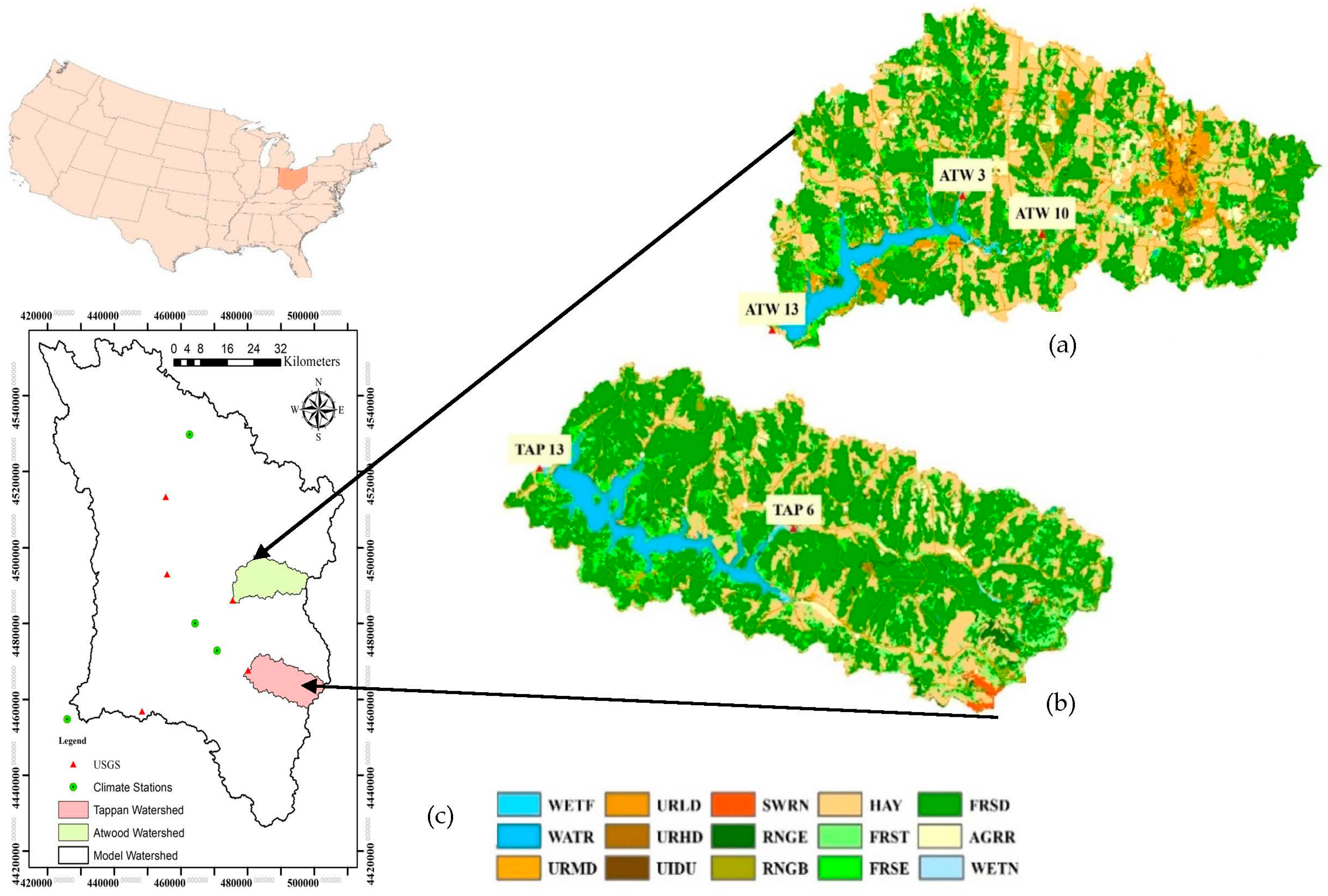
Figure 1. Land use map of the Atwood Lake watershed and nitrogen and phosphorus monitoring stations (a), Tappan Lake watershed (b), and nitrogen and phosphorus monitoring stations within Tuscarawas basin (c). WATR: open water; WETN: emergent herbaceous wetlands; WETF: woody wetlands; URMD: urban medium density; URLD: urban low density; URHD: urban high intensity; UIDU: industrial developed; SWRN: barren land; RNGE: herbaceous; RNGB: shrub/scrub; HAY: hay/pasture; FRST: mixed forest; FRSE: evergreen forest; FRSD: deciduous forest; AGRR: cultivated crops.
Water 15 03028 g001
Figure 2. Flowchart for detailed methodology.
Water 15 03028 g002
Figure 3. SWAT model streamflow calibration (2003–2015), and validation (2016–2020) at 3 USGS gauge stations, namely USGS Gauge 3,129,000 (a), USGS Gauge 3,124,500 (b), and USGS Gauge 3,117,000 (c).
Water 15 03028 g003
Figure 4. Additional streamflow validation at outlets of (a) Atwood Lake watershed (2016–2020) USGS gauge 3,121,500 and (b) Tappan Lake watershed (2017–2020) USGS gauge 3,128,500.
Water 15 03028 g004
Figure 5. Observed TN and TP concentrations at 5 monitoring stations from 2015 to 2022) (a) total nitrogen concentrations and (b) total phosphorus concentrations.
Water 15 03028 g005
Figure 6. Scatter plot of simulated and observed TN and TP at the Atwood and Tappan watershed locations.
Water 15 03028 g006
Figure 7. Box plot for (a) total nitrogen concentrations and (b) total phosphorus concentration at the outlet of the Atwood watershed in various BMPs (2003–2022); BS (base scenario), CC (cover crop), CR (crop rotation), FR (fertilizer reduction), GWW (grass waterways), VFS (vegetative filter strip).
Water 15 03028 g007aWater 15 03028 g007b
Figure 8. Box plot for total nitrogen concentrations (a) and total phosphorus concentrations reduction (b) at the outlet of the Atwood watershed in various BMPs from 2003 to 2022; BS (base scenario), CC (cover crop), CR (crop rotation), FR (fertilizer reduction), GWW (grass waterways), VFS (vegetative filter strip).
Water 15 03028 g008aWater 15 03028 g008b
Figure 9. The average reduction in total nitrogen concentrations (a), and total phosphorus concentrations (b) at the outlet of the Atwood watershed in various BMPs from 2003 to 2022; BS (base scenario), CC (cover crop), CR (crop rotation), FR (fertilizer reduction), GWW (grass waterways), VFS (vegetative filter strip).
Water 15 03028 g009aWater 15 03028 g009b
Figure 10. Box plot for total nitrogen concentrations (a) and total phosphorus concentrations (b) at the outlet of the Tappan watershed in various BMPs (2003–2022) for base scenario (BS), cover crop (CC), crop rotation (CR), fertilizer reduction (FR), grass waterways (GWW), and vegetative filter strip (VFS).
Water 15 03028 g010
Figure 11. Box plot for total nitrogen concentration (a) and total phosphorus concentrations reduction (b) at the outlet of the Tappan watershed in various BMPs from 2003 to 2022 for base scenario (BS), cover crop (CC), crop rotation (CR), fertilizer reduction (FR), grass waterways (GWW), and vegetative filter strip (VFS).
Water 15 03028 g011
Figure 12. Average reduction in total nitrogen concentrations (a) and total phosphorus concentrations (b) at the outlet of the Tappan watershed in various BMPs from 2003 to 2022 for base scenario (BS), cover crop (CC), crop rotation (CR), fertilizer reduction (FR), grass waterways (GWW), and vegetative filter strip (VFS).
Water 15 03028 g012
Figure 13. Average increment in total nitrogen concentrations and total phosphorus concentrations at the outlet of the Atwood watershed (a) and outlet of the Tappan Lake watershed (b) in various rates of cattle grazing. Grazing 25 refers to 25% of cattle grazing in the pasture land, whereas Grazing 100 refers to 100% of cattle grazing and so forth.
Water 15 03028 g013aWater 15 03028 g013b
Figure 14. Comparison of the calibrated and uncalibrated model in the Atwood watershed outlet (upper panel) for total nitrogen concentration reductions (a) and total phosphorus reduction (b), and comparison of the calibrated and uncalibrated model in the Tappan watershed outlet (lower panel) for total nitrogen concentrations reductions (c) and total phosphorus concentrations (d). Note: VFS refers to vegetative filter strip with 1 m and 10% fertilizer reduction, FR refers to 10% fertilizer reduction, CC refers to cover crop (rye) with 10% fertilizer reduction, GWW-CC-FR refers to cover crop (rye) with grass waterways and 10% fertilizer reduction.
Water 15 03028 g014aWater 15 03028 g014b
Table 1. Data and their sources used in the study.
Data Type DataSource
GISDigital Elevation Model USGS, National Elevation Dataset
Land use DataUSGS, National Land Cover Dataset
Soil DataSWAT US SSURGO Soils Database
ClimateRainfall and TemperatureNOAA National Climatic Data Center
HydrologyStream flowUSGS, National Water Information System
Table 2. Monthly flow performance of the SWAT model.
Model OutletUSGS GageCalibration (2003–2015)Validation (2016–2020)
NSER2PBIASRSRNSER2PBIASRSR
13,117,0000.540.72−20.870.670.630.78−18.560.60
43,124,5000.550.64−10.790.670.780.8319.520.47
423,129,0000.790.80−0.090.450.890.92−5.110.33
17 *3,121,500 0.500.5211.290.71
27 **3,128,500 0.560.60−8.400.66
Notes: * Atwood watershed outlet. ** Tappan watershed outlet.
Disclaimer/Publisher’s Note: The statements, opinions and data contained in all publications are solely those of the individual author(s) and contributor(s) and not of MDPI and/or the editor(s). MDPI and/or the editor(s) disclaim responsibility for any injury to people or property resulting from any ideas, methods, instructions or products referred to in the content.