Article

Rain Pattern Deeply Reshaped Total Phosphorus Load Pattern in Watershed: A Case Study from Northern China

1
College of Environmental Science and Engineering, Nankai University, Tianjin 300350, China
2
Tianjin Eco-Environmental Monitoring Center, Tianjin 300191, China
*
Authors to whom correspondence should be addressed.
Water 2023, 15(16), 2910; https://doi.org/10.3390/w15162910
Submission received: 3 July 2023 / Revised: 4 August 2023 / Accepted: 10 August 2023 / Published: 12 August 2023

Abstract

:
Excessive phosphorus in aquatic systems poses a threat to ecosystem stability and human health. Precipitation has a profound influence on the phosphorus biogeochemical process; however, it has been inadequately considered at the watershed scale. In this study, the Bayesian latent variable regression model was utilized to quantify the impact of rainfall on the concentration of total phosphorus using daily monitoring data from 2019 to 2021. The results revealed a piecewise linear relationship between total phosphorus concentration and precipitation. It was further inferred that the breakpoint (The total rainfall during a single rainfall event equal to 39.4 ± 0.45 mm) represented the tipping point for the transformation of the primary river runoff generation mechanism. Subsequently, the excess phosphorus load caused by rainfall events was estimated in the Shahe basin by combining the regional nutrient management approach with the results of the Bayesian latent variable regression model. The results indicated that rainfall events were one of the most significant sources of TP loads from 2006 to 2017, accounting for 28.2% of the total. Non-artificial land, including farmland, forests, and grasslands, serves as the primary source of the excess phosphorus load resulting from rainfall events. This study provides insights into how to quantify the phosphorus load resulting from rainfall events at the basin scale, which is valuable for phosphorus management. Environmental managers should prioritize the regulation of phosphorus in non-artificial land moving forward. Implementing hierarchical management based on calibrated curve numbers and soil phosphorus content could prove to be an efficient approach for regulating phosphorus in the watershed.

1. Introduction

Phosphorus is a vital element in the biogeochemical cycle [1]. Almost no creature can survive without phosphorus. The distribution and total amount of phosphorus profoundly influence ecosystem dynamics [2]. Phosphorus is primarily stored in soil, water, and organisms. Insufficient phosphorus can significantly impact regional biomass and diversity [3,4], whereas excessive phosphorus can disrupt ecosystem balance [5]. Current research has advanced our understanding of the phosphorus biogeochemical process and aided in phosphorus regulation.
Simulating the phosphorus biogeochemical process in a basin remains an effective method for enhancing our understanding. Recently, several modeling methods have been developed, including the Spatially Referenced Regressions On Watershed attributes (SPARROW) model [6], the Soil and Water Assessment Tool (SWAT) [7,8], and the Generalized Watershed Loading Function (GWLF) [9], among others. Additionally, simplified models such as the output coefficient method have also been widely employed [10]. These models are used to calculate the spatial and temporal distribution of phosphorus.
Based on previous research, human activities have been the primary contributor to phosphorus in rivers and lakes in recent decades. Agricultural phosphorus is consistently a significant anthropogenic source [11,12]. Alexander et al. provided insights into nutrient tracing in the Waikato River Basin [13]. The results illustrated that over half of the phosphorus was derived from agricultural activities. Yuan et al. traced the sources of total phosphorus (TP) in the Chaohu watershed, which showed that 55% of the phosphorus came from cropland [14]. Xu et al. estimated the contributions of different phosphorus sources using the SPARROW model. The results showed that over 40% of the phosphorus entering Bohai Bay originated from rural areas [15]. In these areas where agricultural production is active, the main source of phosphorus is farmland.
The pathways of phosphorus from farmland to rivers are commonly categorized as surface runoff and groundwater seepage. Groundwater seepage is a relatively stable form of phosphorus transport due to soil adsorption and desorption [16]. However, phosphorus produced from surface runoff exhibits significant spatio-temporal variability. The transportation of phosphorus through surface runoff is influenced by various factors, including soil type, farming practices, vegetation, slope, rainfall patterns, and more [8,17]. Recent studies have shown that rainfall patterns affect the amount and distribution of nutrients in rivers [18]. Rainstorms can lead to an excessive phosphorus load in rivers, as verified by several relevant field experiments. For example, Wang et al. conducted a series of experiments to measure the response of TP concentration to varying rainfall events [19]. The results suggest that both TP concentration and phosphorus load increase with rainfall intensity, and the relationship between rainfall and TP concentration is non-linear. Rainfall can increase both the TP load and the speed at which it enters the river. However, detailed and quantitative studies at the field scale are more appropriate than at the watershed scale. Additionally, while field experiments yield more accurate results, they are also constrained by specific experimental conditions. Generally, the greater the accuracy of site experiment results, the lower their generalizability due to the spatiotemporal heterogeneity of the watershed environment.
In the watershed, the studies conducted have demonstrated the significance of the relationship between rainstorms and phosphorus loss, which has been quantified using a general empirical equation. However, the method used to quantify this relationship in a specific basin, based on monitoring data, is not robust. Therefore, we sought to determine the relationship between rain patterns and TP concentration through daily monitoring of TP concentration. Subsequently, we conducted simulations and analyses of the TP biogeochemical process to quantify the impact of rain patterns on the TP load in the watershed. This research aims to address three key questions: (1) Does TP concentration respond to rain patterns in a nonlinear manner? (2) What is the magnitude of the additional phosphorus load resulting from extreme rainfall events at the watershed scale? (3) How is the excess phosphorus input temporally distributed?
Based on the previous research, we have developed a simulation tool to assess the TP load in watersheds. This model takes into consideration the excessive phosphorus generated by extreme rainfall, resulting in a more accurate estimate. The modified simulation is beneficial for the improved management of the water environment at the watershed scale. Furthermore, extreme rainfall events cause a rapid increase in river TP levels due to surface runoff. The TP load exhibits a nonlinear relationship with rainfall. Consequently, the phosphorus from non-point sources may be underestimated, which has the potential to impede the achievement of TP control targets in the basin. This study ensures the establishment of more accurate and reasonable TP management targets for the basin.

2. Materials and Methods

2.1. Study Area

The simulation experiments were conducted in the Shahe basin, which is located in Hebei province in northern China. It is a sub-basin of the Yuqiao watershed, which is the source of drinking water in Tianjin city. The Shahe River, being a crucial source for the Yuqiao Reservoir, has a direct impact on its water quality. Consequently, this poses a threat to the water security of Tianjin City downstream [20].
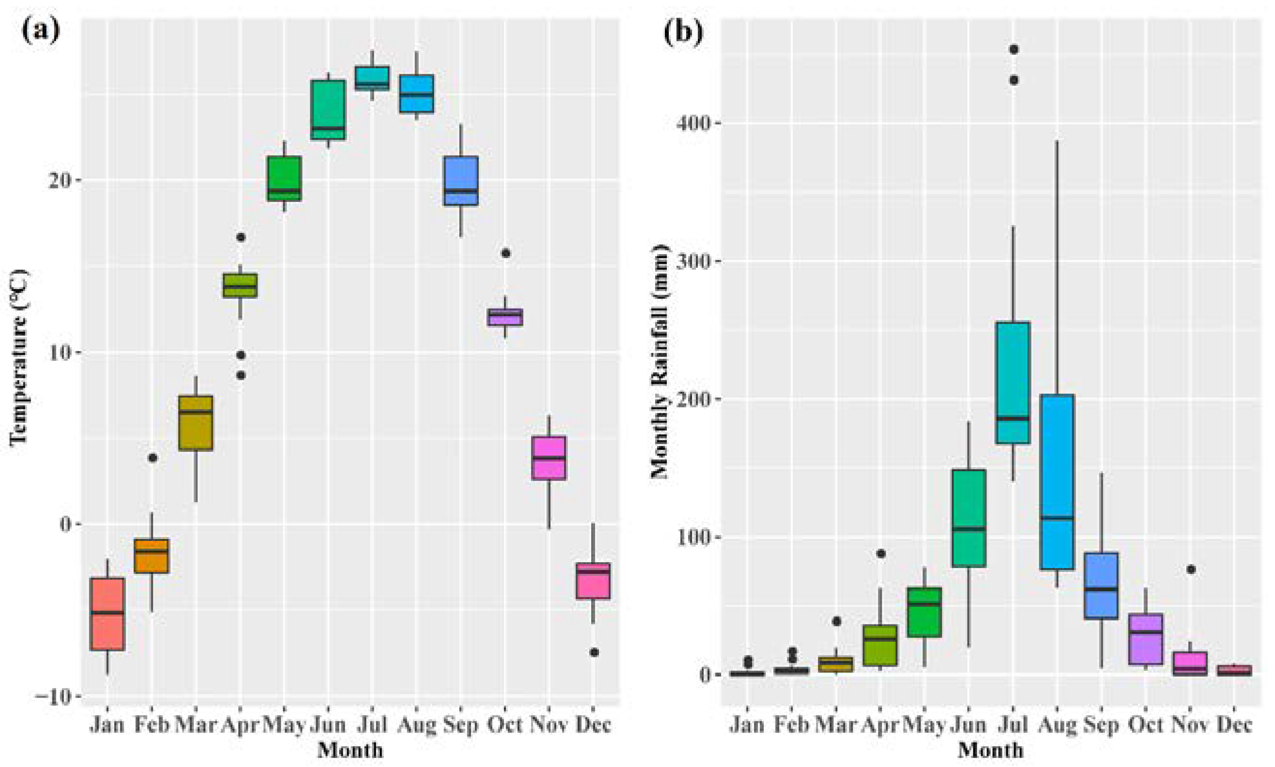
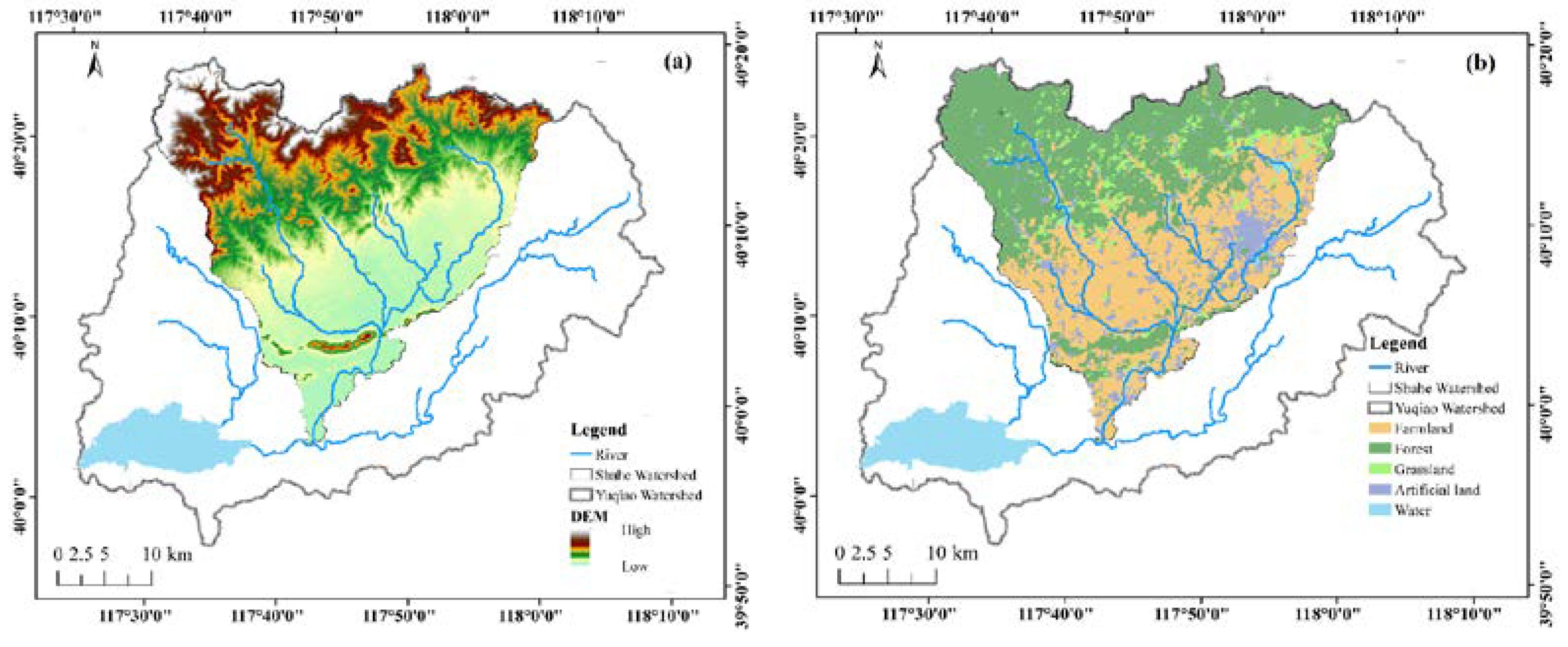
The Shahe basin covers an area of approximately 866.16 km2, with latitude and longitude ranging from 40°1′1″ to 40°23′3″ and from 117°35′10″ to 118°5′14″ (Figure 1). The basin falls within the temperate, semi-humid monsoon climate zone. It has an average elevation of 196 m, an average annual rainfall of 754 mm, and an average annual temperature of 11.7 °C (Figure 2). The Shahe basin exhibits a general trend of higher altitudes in the north and lower altitudes in the south, resulting in a north-to-south flow direction for the river. The northern region of the Shahe basin comprises mountainous terrain, while the central and southern regions are predominantly plains. Zunhua City is situated in the eastern part of the basin. The primary land use types in the Shahe basin include agricultural land, forest land, grassland, construction land, and water bodies (Figure 3). Environmental managers have been grappling with the deterioration of river water quality caused by excessive nutrient discharge in recent years. Consequently, daily water quality monitoring has been implemented at the outlet of the Shahe basin since 2019 to facilitate effective water environment management.

2.2. Data Source

This study utilized a diverse range of data, and Table 1 provides a summary of the information related to these datasets. TP concentrations exhibit two distinct temporal resolutions. Prior to 2018, TP concentrations were monitored on a monthly basis. However, since 2019, daily water quality monitoring has been conducted.

2.3. Bayesian Latent Variable Regression (BLVR)

BLVR has been widely utilized in various fields, including computer science [21], medical informatics [22], political and social research [23], and environmental sciences [24]. Bayesian regression is flexible in accommodating different types of data, allows for the reuse of experimental data, and mitigates the risk of overfitting. The experiences gained from previous studies are incorporated into the model as prior distributions. Moreover, it excels in assessing uncertainty. In accordance with the BLVR model, latent variables are utilized to describe hidden states that are challenging to detect, thereby enhancing accuracy and interpretability.
In this study, we used a piecewise linear model to describe the relationship between Δ c ( TP ) and PreciT. The BLVR is designed as Equations (1)–(4).
Δ c ( TP )   ~   N ( μ ,   σ 2 )
μ = a 0 + a 1 ( 1 k ) + b 0 PreciT + b 1 ( 1 k ) PreciT
σ = σ 0 + σ 1 ( 1 k )
k = 0 if   PreciE ε 1 if   PreciE < ε
where Δ c ( TP ) indicates the increase in TP concentration during each rainfall event. PreciE indicates the total rainfall during a single rainfall event. PreciT indicates the sum of PreciE and the rainfall in the first 30 days. The intercepts ( a 0 and a 1 ), slopes ( b 0 and b 1 ) and stand error ( σ 0 and σ 1 ) are different in every single state (Equations (1)–(3)). In the BLVR model, TP input states (k) are latent variables that are estimated by piecewise functions (Equation (4)). The ε represents the threshold for state transition.
All of the prior distributions were: a 0 ~ N ( 0.01 ,   0.1 ) ;   a 1 ~ N ( 0.01 ,   0.1 ) ;   b 0 ~ N ( 0.01 ,   0.1 ) ;   b 1 ~ N ( 0.01 ,   0.1 ) ; σ 0 ~ Unif ( 0 ,   20 ) ; σ 1 ~ Unif ( 0 ,   20 ) ; ε ~ N ( 40 ,   1 ) .

2.4. ReNuMa (Regional Nutrient Management)

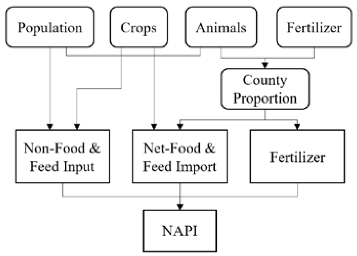
The ReNuMa model is a hydrologically driven and quasi-empirical model that builds upon two previous approaches: GWLF and NAPI (Net Anthropogenic Phosphorus Inputs). The GWLF is a lumped-parameter model that addresses hydrology, sediment, and nutrient transport at the watershed scale. The NAPI is an accounting methodology for quantifying phosphorus inputs to watersheds. It was developed for estimating nutrient fluxes in large watersheds (Figure 4).
The GWLF model provides estimates for monthly loads of dissolved and total nitrogen and phosphorus in streamflow from complex watersheds, incorporating surface runoff, groundwater sources, and nutrient loads from point sources and on-site wastewater disposal (septic) systems.
According to the ReNuMa model, the impact of rain pattern on river TP concentration is negligible. Rain patterns are only considered by first-order wash-off functions when simulating nutrient loads in urban runoff [28]. For the other nutrient sources, monthly river TP concentrations are given by NAPI or directly defined by the user. Therefore, daily TP concentration in a single month is constant for those sources.
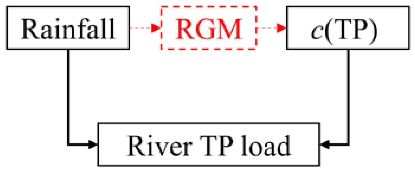
The ReNuMa model did not adequately consider the effect of rain patterns on nutrient loads. Thus, it can be combined with the results of the BLVR to estimate the effect of rain patterns on nutrient loads in the watershed (Figure 5). According to ReNuMa, the basin TP load is calculated by Equation (5).
Load TP = Q · c · A  
where Load TP indicates TP load in the watershed, which is calculated by flow depth (Q), TP concentration (c), and area (A). Those parameters are different for every land use and land cover (LULC). For further details, please refer to the ReNuMa model manual.
Then, the rain pattern was taken into account to calculate the TP load (Equation (6)).
Load TP = Δ event ( Load TP ) + Load TP
where Load TP indicates TP load after adjustment, which was the sum of Load TP and increased TP load from rainfall events ( Δ event ( Load TP ) ).
Δ event ( Load TP ) = d event ·   Q   ·   Δ c ( TP )   · A
where d event indicates duration of rainfall influence. The A indicates land use area except water.
Follow the assumption that the rain pattern is vital for TP load at the watershed scale. The influences of the rain pattern are quantified by comparisons between Load TP and Load TP . Nash-Sutcliffe efficiency coefficient (NSE) and R-squared (R2) were employed to describe simulation accuracy (Equations (8) and (9)).
NSE = 1   ( O b s   S i m ) 2 ( O b s   S i m ) 2
R 2 = 1   ( O b s   S i m ) 2 ( O b s   O b s ) 2

3. Results

3.1. BLVR Modeling Results

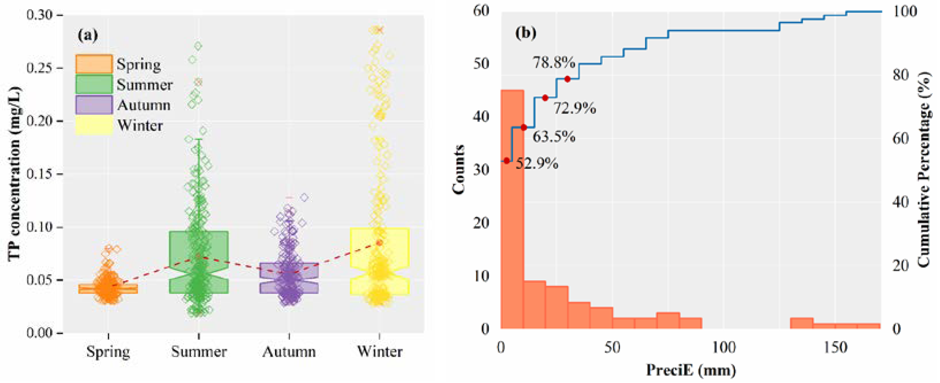
Daily monitoring has been conducted at Shaheqiao station, which serves as the outlet of the Shahe basin, since 2019. TP concentration is one of the water quality indices monitored daily. The daily monitoring data for TP concentrations over a period of approximately three years has been recorded (Table 1 and Figure 6a). Subsequently, the influence of rainfall patterns on river TP concentrations and TP load was analyzed using the daily TP concentrations and precipitation data.
The seasonal distribution of TP concentrations at Shaheqiao station is shown in Figure 6a. The TP concentration was highest during the winter, subsequently decreasing to its lowest level in the spring. The fluctuation may be attributed to the death and growth of organisms. Furthermore, the river TP concentration increased during the summer due to the growth facilitated by biogeochemical and hydrological processes. Subsequently, it stabilized and declined during the autumn (Figure 6a).
Based on daily precipitation monitoring, approximately 85 precipitation events occurred in the Shahe basin from 1 January 2019, to 14 October 2022. The number of precipitation events decreased significantly with an increase in precipitation intensity. More than half of the precipitation events had an intensity below 10 mm (52.9%), while only 21.2% of the events had an intensity exceeding 40 mm (Figure 6b).
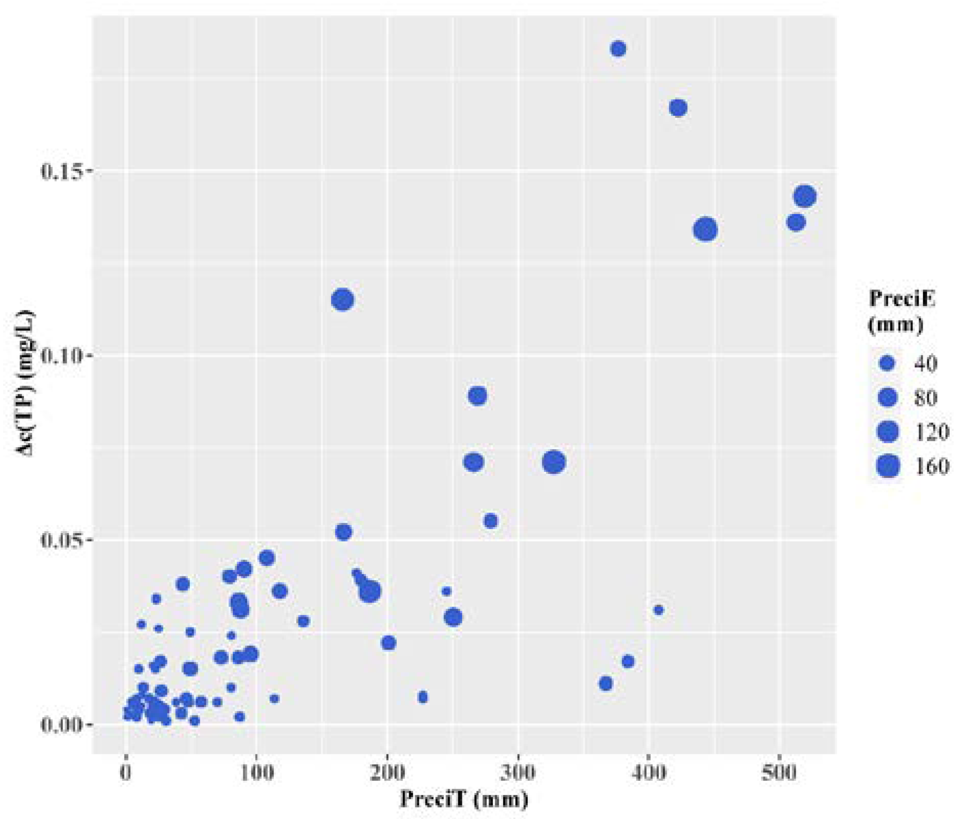
The relationship between Δ c ( TP ) and PreciT is shown in Figure 7. Both PreciT and PreciE contributed to an increase in river Δ c ( TP ) . Therefore, river TP concentrations exhibited a nonlinear response to precipitation. Subsequently, BLVR was employed to further investigate the fluctuations of river Δ c ( TP ) in response to precipitation.
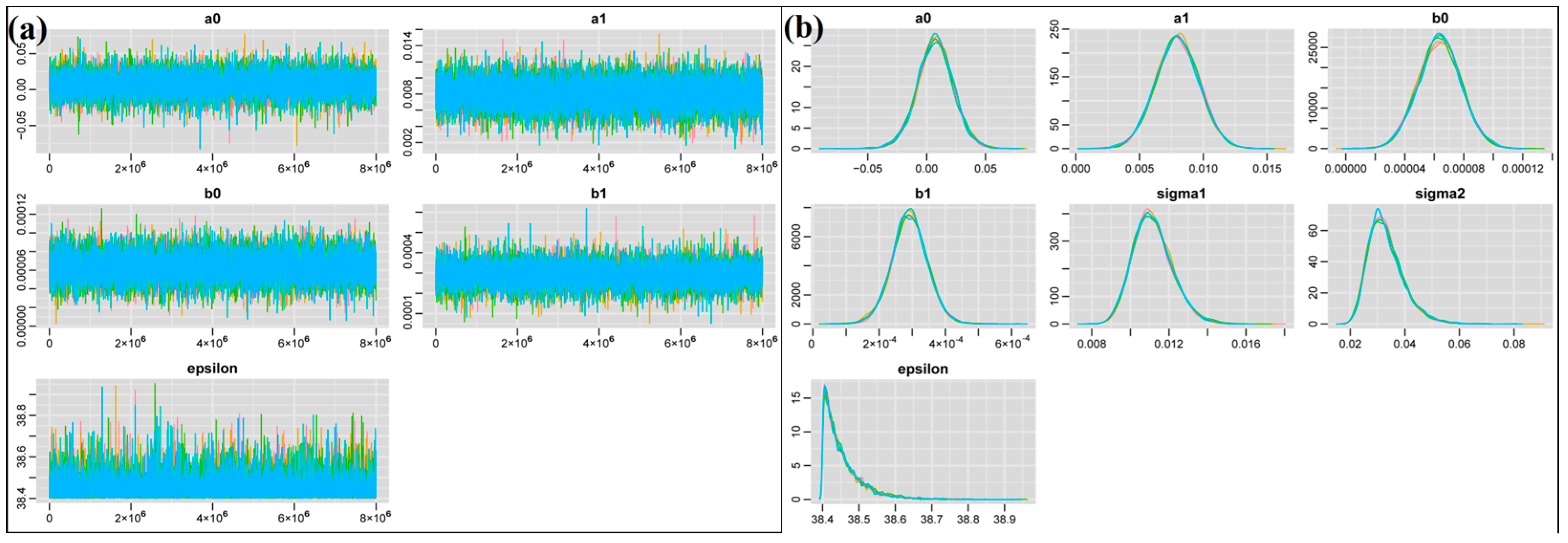
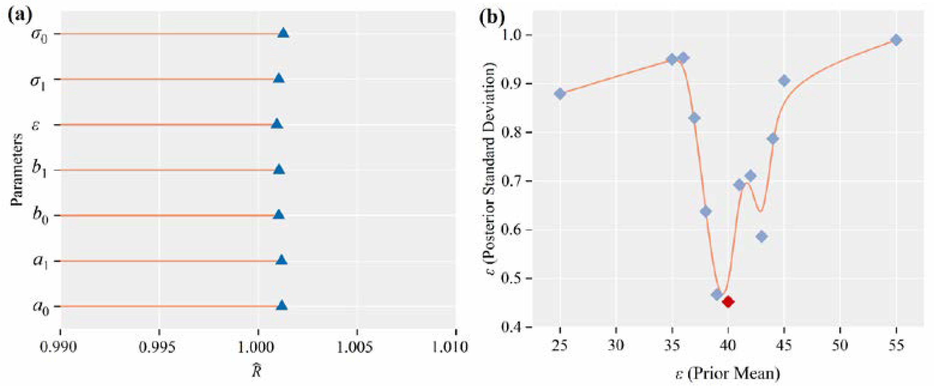
BLVR was constructed using a Bayesian model (Equations (1)–(4)). The calibration of parameters was accomplished using the Markov Chain Monte Carlo (MCMC) method. Five chains were utilized to verify convergence. The trace diagram displays the sampled values of the parameters during the MCMC iteration process. These trajectory plots indicate that both models have reached convergence (Figure 8). The five chains show a mixed distribution for all parameters, with no clear trend observed. The R ^ value serves as a quantitative convergence diagnostic method that compares the parameter estimates of each chain. If the chain has successfully converged and mixed, the R ^ value should be close to 1. The R ^ values in Table 2, all below 1.01, indicate that the results have achieved convergence (Figure 9a).
The results of the parameter posterior distributions are summarized in Table 3. The mean of the posterior distribution for ε is 39.4 mm, based on a prior mean of 40 mm. It should be noted that the posterior distribution can be influenced by prior assumptions. To assess this, we conducted simulations with different prior means for ε and observed the resulting posterior distribution (Figure 9b). From the comparison with the posterior standard deviation of ε , the prior mean of 40 mm appears to be reasonable. Consequently, the threshold value for PreciE is determined to be 39.4 mm, which also serves as the breakpoint for the Bayesian regression analysis. It is important to note that the latent states depend on this threshold value, although their meanings are not clearly defined.
The piecewise regression results are shown in Figure 10, suggesting that the effect of precipitation on river TP concentrations is not consistent. This phenomenon is evident in the nonlinear relationship between c ( TP ) and P r e c i T as shown in Figure 8. When PreciE exceeds 39.4 mm, the slope of the regression line noticeably increases. Moreover, c ( TP ) exhibited a moderate increase with PreciT when PreciE was below 39.4 mm.

3.2. Hydrological and Nutrient Modeling

The TP load was influenced by several factors in the basin. In order to assess the impact of rainfall patterns on TP loads, it was necessary to simulate the TP load production process. The ReNuMa was utilized in this study to trace nutrient sources in the basin and simulate the distribution of nutrients across different land areas. Monthly streamflow depth was simulated using the Soil Conservation Service-Curve Number (SCS-CN) method embedded within the GWLF. The Nash–Sutcliffe Efficiency (NSE) for the simulation of monthly streamflow depths was 0.84 during the training period and 0.74 during the prediction period (Figure 11a). The three reservoirs constructed upstream of the Shahe basin exert control over the streamflow. Therefore, artificial control may be the main factor driving the uncertainty in hydrological simulations. The simulation accuracy throughout the entire period was deemed acceptable (NSE = 0.78), indicating the reasonableness of the hydrological simulation. The subsequent monthly TP load simulation was conducted based on the hydrological simulation.
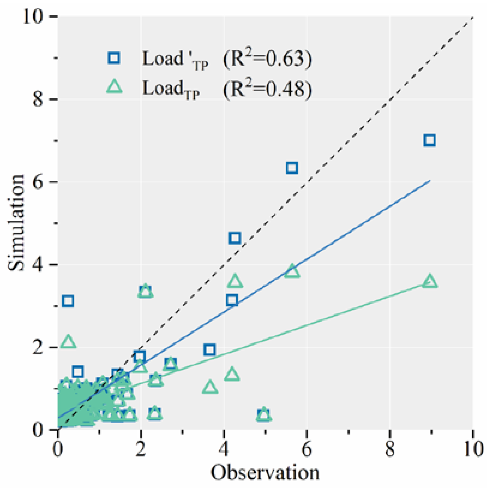
The TP load simulation exhibits low accuracy in the original ReNuMa model ( Load TP ). The NSE values were only 0.48 during the training period and 0.18 during the prediction period (Figure 11b). While some uncertainty may arise from hydrological simulation, the main cause lies in the absence of specific simulations of biogeochemical processes in the Shahe basin, particularly regarding rainstorms. Therefore, more comprehensive TP load simulations were conducted during the same period, taking into account the additional TP input from rainstorms ( Load TP ). The NSE of the simulations increased noticeably during different time periods to varying degrees (Figure 11b and Table 4). These improvements were primarily observed during the rainy season (Figure 11 and Figure 12). The modified TP simulations are relatively acceptable, despite their modest level of accuracy. The TP concentration observation in March 2016 was abnormal, resulting in an extremely high TP load and low precision. Furthermore, when excluding the abnormal data, the NSE of the modified TP simulations improved from 0.61 to 0.73 throughout the entire simulation period. Consequently, the modified TP load simulations are also considered reasonable.
The ReNuMa model utilizes coupled simulations of watershed hydrological processes and nutrient processes to provide robust nutrient simulation results. In the ReNuMa model, different LULCs are associated with distinct hydrological and biogeochemical processes. Therefore, the simulation results are capable of estimating nutrient loads from various LULCs.
Here, we calculated the TP load contributions from each type of landscape and conducted further pooled analysis (Figure 13). The primary sources of TP load are farmland and artificial land, which have contributed 44.9% and 36.9%, respectively, over all years. The contribution from waterbodies remains relatively stable throughout the year. The contribution of artificial land to the TP load decreases over time, indicating progress in reducing urban pollution.
The annual TP load contribution pattern has been reshaped when considering TP loads associated with rainfall events. Rainfall events are among the most significant sources of TP load, accounting for 28.2% of the total. Furthermore, rainfall events have resulted in extreme TP loads during high flow years (2012–2013 and 2016–2017). The average contributions of farmland and artificial land have decreased to 31.2% and 33.3%, respectively.

4. Discussion

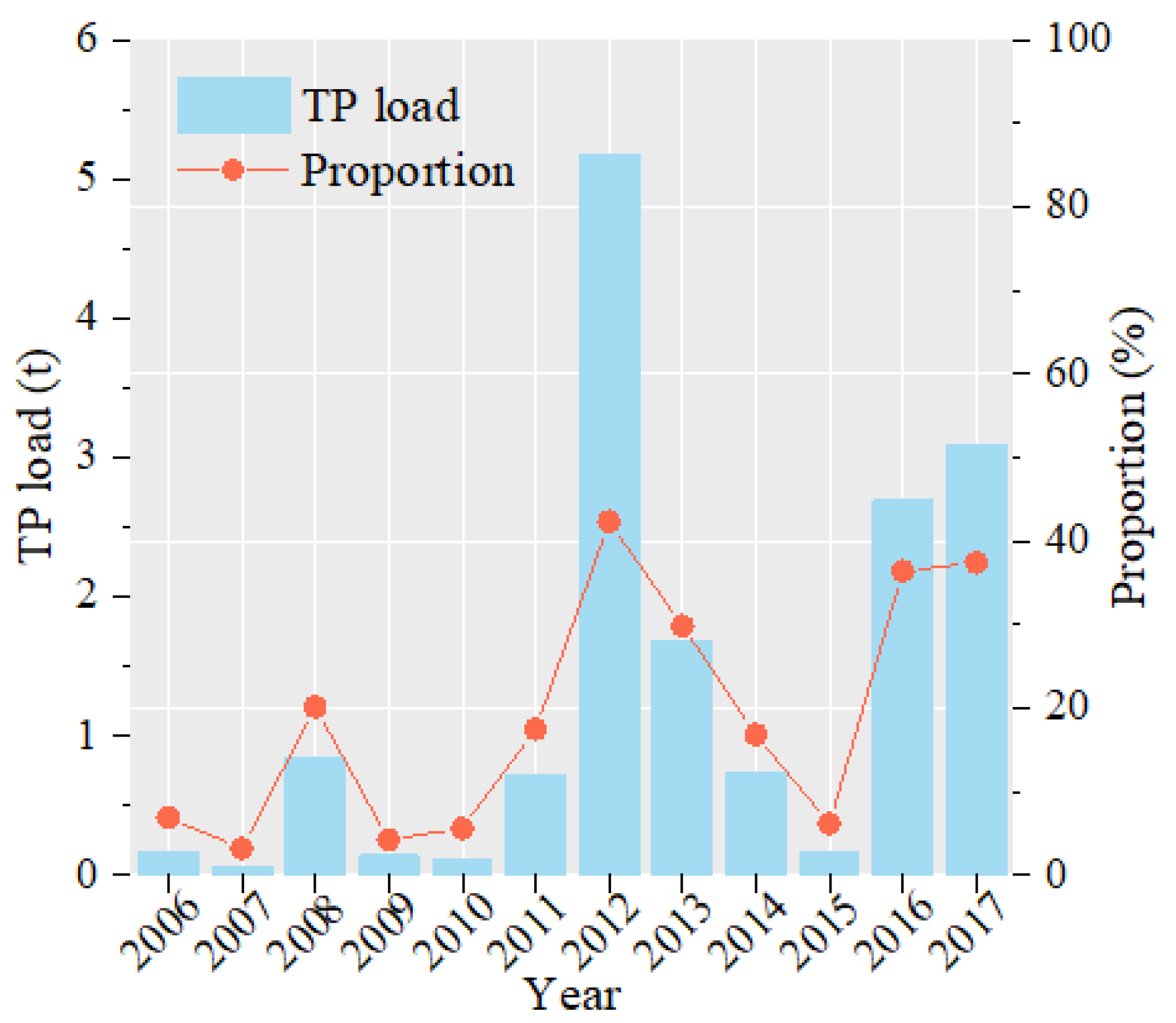
According to the model results and the observations, TP load is concentrated in the summer for all years (Figure 11). Thus, the TP load in the summer has directly controlled the yearly load. Moreover, the proportions of additional TP input due to rainfall in the summer fluctuate with the precipitation. Over 40% of TP derives from rainfall events in the summer in partial years with high rainfall. However, the greatest proportion still floats around 40%, even though the TP load caused by rainfall increased sharply (Figure 11).
There has been a noticeable reduction in urban pollution sources (Figure 13). However, there has been a simultaneous increase in non-point source pollution caused by heavy rainfall events (Figure 14), which can potentially be attributed to the escalating frequency of extreme precipitation due to climate change. This phenomenon is significantly altering the distribution of total phosphorus (TP) sources within the basin. As a result, the non-linear influx of non-point source pollution is assuming a progressively crucial role. The additional load of total phosphorus (TP) originating from non-artificial land constitutes a significant portion of non-point source pollution within a watershed. This observation underscores the crucial role of meteorological factors in the management of the water environment within river basins, aligning with the findings of TP traceability analysis conducted by Zhang et al. (2020) in the Yuqiao Reservoir basin [29]. Consequently, it is imperative for the pertinent environmental management authorities to devote due attention to this emerging concern.
The inclusion of urban surface erosion runoff loads in GWLF models allows for an assessment of the primary source of additional TP input resulting from rainfall, which is predominantly found to originate from non-artificial land. This characteristic makes the GWLF model an essential choice for conducting research in this area. Moreover, the construction of an urban drainage system in Zunhua City, situated within the Shahe Basin, has been enhanced since 2018. As a result, urban rainwater is predominantly discharged into the river through the drainage network. The calibrated threshold ε for the BLVR model is determined to be 39.4 mm, which may need to be reduced if urban runoff is found to primarily contribute to a non-linear increase in TP concentration. Thus, the non-artificial land is further verified as mainly sources to TP concentration nonlinear increase.
Some field experiments have concluded that rain patterns change nutrient concentrations in the output runoff by changing the runoff generation mechanism (RGM). In the study of river basin scale, the change in RGM is likely to be an important reason for the increase in TP in rivers during heavy rainfall. When PreciE is greater than 39.4 mm, more rainwater enters the river channel through surface runoff and also washes various substances from the rural land (e.g., farmland, woodland, and grassland) into the river. The rate and amount of phosphorus collected in this process may be higher than during periods of low runoff. The change in the TP concentration of runoff caused by the production flow mechanism is often nonlinear, which corresponds to the nonlinear relationship found in the paper.
The findings from field experiments to watershed simulations, including the present study, have consistently demonstrated the promoting effect of rain patterns on nutrient output [18,30]. It is important to note that rainfall does not exert a uniform impact on nutrient output, as it not only influences water quantity but also elevates nutrient concentration in runoff (Figure 15). Regrettably, conventional models frequently overlook the potential influence of rainfall patterns on the concentration of total phosphorus. However, the objective of this study is to address this gap by undertaking a speculation- and simulation-based approach to unravel the intricate processes through which rainfall patterns indirectly influence the total phosphorus concentration in runoff. By comprehensively exploring the mechanisms governing nutrient production and transfer, our aim is to provide a comprehensive understanding of how these patterns ultimately shape the total phosphorus load in rivers. By solely considering a singular approach in the assessment of pollution sources, there is a risk of underestimating nutrient output from agricultural land, which indirectly impacts the formulation of effective nutrient management policies within the watershed.
Moreover, previous studies have provided evidence for the influence of rainfall on total phosphorus (TP) loads at different basin scales. For instance, Yin et al. employed the SPARROW model to simulate TP concentrations in the expansive Poyang Lake basin. By incorporating the seasonal variation of rainfall through a Bayesian approach, they achieved significant improvements in simulation accuracy [31]. The Poyang Lake basin, encompassing an area of approximately 160,000 km2, signifies that the non-linear contribution of total soil phosphorus to rivers due to intense rainfall could potentially manifest on a larger spatial scale. Consequently, the impact of this mechanism on TP loads within rivers across extensive river basins becomes non-trivial. Notably, even within smaller watersheds, the aforementioned non-linear relationship might be of greater magnitude. This is exemplified by the Lake Mendota watershed in southern Wisconsin, which spans a mere 604 km2. Carpenter et al. unveiled the correlation between TP loads and extreme precipitation events within this compact watershed [32]. Thus, the inference of rain patterns asserting a universal regulatory influence on TP loads can be extended across varying spatial scales.
However, it is important to note that rainfall does not always lead to an increase in TP concentrations in rivers. An example of this can be observed in Kasumigaura Lake, located in Ibaraki Prefecture, Japan, where the TP concentration in the rivers entering the lake does not show a clear relationship with rainfall in the preceding ten days. And in some cases, it is even negatively correlated [33]. This suggests that the flushing effect of rainfall events may be outweighed by their dilution effect on the TP content of the water body. In the Shahe Basin, there is a weak inverse relationship between the total monthly rainfall and the average monthly TP concentration, with the highest TP concentrations observed in winter. This indicates that the relationship between rainfall and river TP concentration may vary depending on the temporal scale, as also mentioned in existing literature [34,35,36,37,38]. These findings suggest that different driving forces may be responsible for changes in TP concentration at different time scales.
On a timescale of several days, the TP concentration in the Shahe River exhibits an increase on the day of rainfall or a few days after rainfall, with the magnitude of the increase corresponding to the intensity of the rainfall, as discussed earlier. This short-term increase in TP concentration during summer contradicts the trend observed on a monthly scale, suggesting that heavy rainfall events serve as the primary driver of TP concentration in the river within a few days, despite an overall downward trend. Similarly, on an annual scale, the patterns of variation and driving factors influencing TP concentration in the river may differ from those observed on monthly and daily scales. The regularity observed on an annual scale may be attributed to the long-term management of TP nutrient loads within the basin over the course of several years [34,39].
The daily concentration of TP in rivers is influenced by a combination of various drivers. Theoretically, any driver has the potential to be the primary driver, even if its impact may be short-lived. However, in practice, different areas exhibit unique characteristics, and not every factor within a specific watershed has the opportunity to become the main driver. This highlights the fact that in certain river basins, rainfall may not hold the potential to be a significant driver. Consequently, the concentration of TP in rivers does not always exhibit an increase in response to rainfall, even on a daily scale. This suggests that while short-term increases in nutrient load within river channels during the rainy season may be driven by rainfall, it is still crucial to establish multi-year targets for managing nutrient loads within watersheds.
The GWLF model used in this study takes into account the urban rainfall erosion effect, which implies that the contribution of TP from rainfall events primarily stems from non-point sources such as farmland, woodland, and grassland. Consequently, the soil phosphorus content in non-artificial land plays a crucial role in determining the TP load resulting from rainfall. Based on our findings, we propose that rainfall patterns indirectly influence the TP load from non-point sources and its spatiotemporal distribution by impacting the flow generation pattern. Furthermore, it can be inferred that the runoff generation capacity of different land types indirectly affects their contribution to the TP load. In light of this, managers can classify non-urban land based on soil phosphorus content and the runoff generation capacity of different land types for effective management strategies.
Human land use practices have a direct impact on runoff yield capacity (RYC) and soil TP content, as depicted by the black solid line in Figure 16. The red zone represents areas with high RYC and soil TP content, indicating a risk zone. Conversely, the green zone represents a safe zone with lower values for both RYC and soil TP content. The yellow zone corresponds to areas with a single factor exhibiting low values, designating it as a control zone. Generally, forest and grassland exhibit smaller TP content and RYC compared to farmland. In a risk zone characterized by forest and grassland, the management strategy should prioritize the reduction of RYC through increased vegetation cover, followed by implementing non-point source management measures to decrease soil phosphorus content, as illustrated by the cyan dotted line in Figure 16. In risk areas with farmland, the management approach should focus on reducing soil TP content through minimizing fertilizer application intensity, followed by regulating RYC using measures such as constructing water conservancy facilities and improving farming methods, as indicated by the blue dotted line in Figure 16. This management strategy aligns with Zhang et al., who employed the Universal Soil Loss Equation (USLE) to classify different phosphorus pollution control zones based on soil phosphorus content [40]. However, in this study, soil TP management zones are determined by calibrated CN values representing RYC and total soil TP content. The calibrated CN values in the GWLF incorporate information from the USLE and meteorological data, rendering the classification more specific compared to solely relying on the USLE.

5. Conclusions

The nonlinear relationship between rain pattern and TP concentration is quantified using the BLVR model. And then we estimated the effect of this nonlinear relationship on the TP load in the Shahe basin. Furthermore, we obtained the following results:
(1)
The effect of precipitation on river TP concentrations is not consistent. The breaking point of PreciE (ε) is 39.4 ± 0.45 mm. This nonlinear relationship is inferred to be caused by the transformation of the primary streamflow production pattern;
(2)
In the Shahe basin, rainfall events were among the most significant sources of TP load during 2006–2017, accounting for 28.2% of the total. And the non-artificial land is the fundamental source of the excess TP load caused by rainfall events;
(3)
Due to the change of main factors, the trend of total phosphorus concentration in different time scales was inconsistent;
(4)
Environmental managers can use calibrated CN values and soil TP content to classify the non-artificial land in the watershed.

Author Contributions

H.D.: Investigation, Methodology, Conceptualization, Software, Writing—original draft, Writing—review and editing. Z.L.: Data curation, Investigation. Y.W.: Conceptualization, Investigation, Supervision. C.W.: Formal analysis, Visualization. Q.R.: Formal analysis, Visualization. H.C.: Visualization. All authors have read and agreed to the published version of the manuscript.

Funding

This research was funded by the Major Science and Technology Program for Water Pollution Control and Treatment (2017ZX07301-001).

Data Availability Statement

Restrictions apply to the availability of these data. Data were obtained from Tianjin Eco-Environmental Monitoring Center and are available from Zeli Li with the permission of Tianjin Eco-Environmental Monitoring Center.

Acknowledgments

This study was supported by the National Water Pollution Control and Treatment Science and Technology Major Project (2017ZX07301-001).

Conflicts of Interest

The authors declare that they have no known competing financial interests or personal relationships that could have appeared to influence the work reported in this paper.

References

  1. Peñuelas, J.; Poulter, B.; Sardans, J.; Ciais, P.; Van Der Velde, M.; Bopp, L.; Boucher, O.; Godderis, Y.; Hinsinger, P.; Llusia, J.; et al. Human-induced nitrogen–phosphorus imbalances alter natural and managed ecosystems across the globe. Nat. Commun. 2013, 4, 2934. [Google Scholar] [CrossRef] [PubMed] [Green Version]
  2. Hou, E.; Luo, Y.; Kuang, Y.; Chen, C.; Lu, X.; Jiang, L.; Luo, X.; Wen, D. Global meta-analysis shows pervasive phosphorus limitation of aboveground plant production in natural terrestrial ecosystems. Nat. Commun. 2020, 11, 637. [Google Scholar] [CrossRef] [PubMed] [Green Version]
  3. Li, Y.; Niu, S.; Yu, G. Aggravated phosphorus limitation on biomass production under increasing nitrogen loading: A meta-analysis. Global Chang. Biol. 2016, 22, 934–943. [Google Scholar] [CrossRef] [PubMed]
  4. Zemunik, G.; Turner, B.; Lambers, H.; Laliberté, E. Diversity of plant nutrient-acquisition strategies increases during long-term ecosystem development. Nat. Plants 2015, 1, 15050. [Google Scholar] [CrossRef]
  5. Yuan, Z.; Chen, H. Decoupling of nitrogen and phosphorus in terrestrial plants associated with global changes. Nat. Clim. Chang. 2015, 5, 465–469. [Google Scholar] [CrossRef]
  6. Alexander, R.B.; Smith, R.; Schwarz, G. Effect of stream channel size on the delivery of nitrogen to the Gulf of Mexico. Nature 2000, 403, 758–761. [Google Scholar] [CrossRef]
  7. Baker, T.J.; Miller, S.N. Using the Soil and Water Assessment Tool (SWAT) to assess land use impact on water resources in an East African watershed. J. Hydrol. 2013, 486, 100–111. [Google Scholar] [CrossRef]
  8. Hou, X.; Xu, Z.; Tang, C.; Zhang, S. Spatial distributions of nitrogen and phosphorus losses in a basin and responses to best management practices—Jialing River Basin case study. Agric. Water Manag. 2021, 255, 107048. [Google Scholar] [CrossRef]
  9. Swaney, D.P.; Sherman, D.; Howarth, R.W. Modeling water, sediment and organic carbon discharges in the Hudson-Mohawk basin: Coupling to terrestrial sources. Estuaries 1996, 19, 833–847. [Google Scholar] [CrossRef]
  10. Zhang, B.; Cui, B.; Zhang, S.; Wu, Q.-Y.; Yao, L. Source apportionment of nitrogen and phosphorus from non-point source pollution in Nansi Lake Basin, China. Environ. Sci. Pollut. Res. 2018, 25, 19101–19113. [Google Scholar] [CrossRef] [PubMed]
  11. Ma, Z.; Luo, M.; Wang, Q.; Li, C.; Guo, L.; Wu, S.; Kazery, J.; Yan, Y.; Zhai, L.; Liu, H.; et al. Long-Term Agronomic Practices in Reducing Nitrogen and Phosphorus Loss from Intensive Croplands. ACS Earth Space Chem. 2022, 6, 1627–1639. [Google Scholar] [CrossRef]
  12. Maccoux, M.J.; Dove, A.; Backus, S.M.; Dolan, D.M. Total and soluble reactive phosphorus loadings to Lake Erie: A detailed accounting by year, basin, country, and tributary. J. Great Lakes Res. 2016, 42, 1151–1165. [Google Scholar] [CrossRef] [Green Version]
  13. Alexander, R.B.; Elliott, A.H.; Shankar, U.; McBride, G.B. Estimating the sources and transport of nutrients in the Waikato River Basin, New Zealand. Water Resour. Res. 2002, 38, 4-1–4-23. [Google Scholar] [CrossRef]
  14. Yuan, Z.; Wu, H.; He, X.; Liu, X. A bottom-up model for quantifying anthropogenic phosphorus cycles in watersheds. J. Clean Prod. 2014, 84, 502–508. [Google Scholar] [CrossRef]
  15. Xu, Z.; Ji, Z.; Liang, B.; Song, D.; Lin, Y.; Lin, J. Estimate of nutrient sources and transport into Bohai Bay in China from a lower plain urban watershed using a SPARROW model. Environ. Sci. Pollut. Res. 2021, 28, 25733–25747. [Google Scholar] [CrossRef]
  16. Edwards, A.C.; Withers, P.J.A. Transport and delivery of suspended solids, nitrogen and phosphorus from various sources to freshwaters in the UK. J. Hydrol. 2008, 350, 144–153. [Google Scholar] [CrossRef]
  17. Bai, H.; Chen, Y.; Wang, Y.; Song, Z.; Tong, H.; Wei, Y.; Yu, Q.; Xu, Z.; Yang, S. Contribution rates analysis for sources apportionment to special river sections in Yangtze River Basin. J. Hydrol. 2021, 600, 126519. [Google Scholar] [CrossRef]
  18. Williams, M.R.; King, K.W. Changing rainfall patterns over the Western Lake Erie Basin (1975–2017): Effects on tributary discharge and phosphorus load. Water Resour. Res. 2020, 56, e2019WR025985. [Google Scholar] [CrossRef]
  19. Wang, L.; Liang, T.; Zhang, Q. Laboratory experiments of phosphorus loss with surface runoff during simulated rainfall. Environ. Earth Sci. 2013, 70, 2839–2846. [Google Scholar] [CrossRef]
  20. Ding, H.; Li, Z.; Ren, Q.; Chen, H.; Song, M.; Wang, Y. Single-variable method for predicting trends in chlorophyll a concentration based on the similarity of time series. Ecol. Indic. 2022, 140, 109027. [Google Scholar] [CrossRef]
  21. Ge, Z. Mixture Bayesian Regularization of PCR Model and Soft Sensing Application. IEEE Trans. Ind. Electron. 2015, 62, 4336–4343. [Google Scholar] [CrossRef]
  22. Song, X.Y.; Pan, D.; Liu, P.F.; Cai, J.H. Bayesian analysis of transformation latent variable models with multivariate censored data. Stat. Methods Med. Res. 2016, 25, 2337–2358. [Google Scholar] [CrossRef]
  23. Feng, X.N.; Wu, H.T.; Song, X.Y. Bayesian adaptive lasso for ordinal regression with latent variables. Sociol. Methods Res. 2017, 46, 926–953. [Google Scholar] [CrossRef]
  24. Vitense, K.; Hanson, M.A.; Herwig, B.R.; Zimmer, K.D.; Fieberg, J. Uncovering state-dependent relationships in shallow lakes using Bayesian latent variable regression. Ecol. Appl. 2018, 28, 309–322. [Google Scholar] [CrossRef]
  25. Russell, M.J.; Weller, D.E.; Jordan, T.E.; Sigwart, K.J.; Sullivan, K.J. Net anthropogenic phosphorus inputs: Spatial and temporal variability in the Chesapeake Bay region. Biogeochemistry 2008, 88, 285–304. [Google Scholar]
  26. Han, H.; Bosch, N.; Allan, J.D. Spatial and temporal variation in phosphorus budgets for 24 watersheds in the Lake Erie and Lake Michigan basins. Biogeochemistry 2011, 102, 45–58. [Google Scholar] [CrossRef]
  27. Hong, B.; Swaney, D. Regional Nutrient Management (ReNuMa) Model, Version 1.0. User’s Manual, February. 2007. Available online: http://www.eeb.cornell.edu/biogeo/nanc/usda/renuma.htm (accessed on 14 September 2022).
  28. Amy, G.; Pitt, R.; Singh, R.; Bradford, W.L.; LaGraffi, M.B. Water Quality Management Planning for Urban Runoff; EPAA4OI9-75-004; U.S. Environmental Protection Agency: Washington, DC, USA, 1974. [Google Scholar]
  29. Zhang, C.; Yan, Q.; Kuczyńska-Kippen, N.; Gao, X. An Ensemble Kalman Filter approach to assess the effects of hydrological variability, water diversion, and meteorological forcing on the total phosphorus concentration in a shallow reservoir. Sci. Total Environ. 2020, 724, 138215. [Google Scholar] [CrossRef]
  30. Wu, L.; Li, P. Studies on rainfall process, flow-making and nitrogen and phosphorus losses. Acta Sci. Circumstantiae 1996, 1, 111–116. [Google Scholar]
  31. Yin, J.; Chen, H.; Wang, Y.; Guo, L.; Li, G.; Wang, P. Ammonium Nitrogen Streamflow Transport Modelling and Spatial Analysis in Two Chinese Basins. Water 2022, 14, 209. [Google Scholar] [CrossRef]
  32. Carpenter, S.R.; Booth, E.G.; Kucharik, C.J. Extreme precipitation and phosphorus loads from two agricultural watersheds. Limnol. Oceanogr. 2018, 63, 1221–1233. [Google Scholar] [CrossRef]
  33. Fukushima, T.; Kitamura, T.; Matsushita, B. Lake water quality observed after extreme rainfall events: Implications for water quality affected by stormy runoff. SN Appl. Sci. 2021, 3, 841. [Google Scholar] [CrossRef]
  34. Wang, M.; Xu, X.; Wu, Z.; Zhang, X.; Sun, P.; Wen, Y.; Wang, Z.; Lu, X.; Zhang, W.; Wang, X.; et al. Seasonal Pattern of Nutrient Limitation in a Eutrophic Lake and Quantitative Analysis of the Impacts from Internal Nutrient Cycling. Environ. Sci. Technol. 2019, 53, 13675–13686. [Google Scholar] [CrossRef]
  35. Zeng, H.; Wang, J.; Li, Y. Water quality change and influencing factors in Lake Hongfeng (Guizhou Province), 2009–2018. J. Lake Sci. 2020, 32, 676–687. [Google Scholar]
  36. Fu, S.; Ni, J.; He, B.; Li, T.-Y.; Tang, Y.; Qian, T.; Xiang, K.-C. Spatial-temporal Distribution of Nutrients in Hanfeng Lake After Official Operation. Environ. Sci. 2020, 41, 2116–2126. [Google Scholar]
  37. Wade, A.J.; Palmer-Felgate, E.J.; Halliday, S.J.; Skeffington, R.A.; Loewenthal, M.; Jarvie, H.P.; Bowes, M.J.; Greenway, G.M.; Haswell, S.J.; Bell, I.M.; et al. Hydrochemical processes in lowland rivers: Insights from in situ, high-resolution monitoring. Hydrol. Earth Syst. Sci. 2012, 16, 4323–4342. [Google Scholar] [CrossRef] [Green Version]
  38. Strohmenger, L.; Fovet, O.; Akkal-Corfini, N.; Dupas, R.; Durand, P.; Faucheux, M.; Gruau, G.; Hamon, Y.; Jaffrezic, A.; Minaudo, C.; et al. Multitemporal Relationships Between the Hydroclimate and Exports of Carbon, Nitrogen, and Phosphorus in a Small Agricultural Watershed. Water Resour. Res. 2020, 56, e2019WR026323. [Google Scholar] [CrossRef]
  39. Van Meter, K.J.; Van Cappellen, P.; Basu, N.B. Legacy nitrogen may prevent achievement of water quality goals in the Gulf of Mexico. Science 2018, 360, 427–430. [Google Scholar] [CrossRef] [Green Version]
  40. Zhang, S.; Chen, L.; Fu, B. Pollution-controlling Regionalization of Agricultural non-point Phosphorous in Yuqiao Reservoir Watershed. Sci. Geogr. Sin. 2004, 2, 232–237. [Google Scholar]
Figure 1. The location of Shahe basin.
Water 15 02910 g001
Figure 2. Average monthly temperature (a) and monthly rainfall (b) (2006–2020).
Water 15 02910 g002
Figure 3. The DEM (a) and land-use types (b) of the Shahe basin.
Water 15 02910 g003
Figure 4. The structure of NAPI [25,26,27].
Water 15 02910 g004
Figure 5. Hydrological model structure of modified ReNuMa [27]. The red processes are the hypotheses in this work.
Water 15 02910 g005
Figure 6. The TP concentration seasonal distribution of Shaheqiao station (a) and the cummulative distribution of PreciE (b) from 1 January 2019 to 14 October 2022.
Water 15 02910 g006
Figure 7. The Δ c ( TP ) vs. PreciT .
Water 15 02910 g007
Figure 8. The sampling trace of MCMC (a) and posterior probability of parameters (b) when the prior mean of ε is 40 mm.
Water 15 02910 g008
Figure 9. Convergence coefficient ( R ^ ) of MCMC (a) and posterior standard deviation of ε for different prior distributions (b).
Water 15 02910 g009
Figure 10. Result of BLVR between c ( TP ) and P r e c i T . The cyan and red shades are both 97.5% confidence intervals of BLVR.
Water 15 02910 g010
Figure 11. The simulation results of monthly streamflow depth (a). The TP load in the Shahe watershed is simulated by the original ReNuMa (b) and the modified ReNuMa (c).
Water 15 02910 g011
Figure 12. The simulation performances of Load TP and Load TP (2006–2017).
Water 15 02910 g012
Figure 13. Annual contribution proportions of Load TP (a) and Load TP (b).
Water 15 02910 g013
Figure 14. The TP load in the summer and its proportions caused by rainfall.
Water 15 02910 g014
Figure 15. Schematic of TP load effected by several indicators.
Water 15 02910 g015
Figure 16. TP management zones. (The risk zone is red; the control zone is yellow; the safe zone is green).
Water 15 02910 g016
Table 1. Data source and format.
Dataset NameSourceFormatResolution
demGeospatial Data Cloud
https://www.gscloud.cn/ (accessed on 25 September 2020)
Raster30 m × 30 m
LanduseTianjin Eco-Environmental Monitoring CenterRaster280 m × 280 m
PopulationNational Earth System Science Data Center
http://www.geodata.cn/ (accessed on 7 October 2018)
Raster1 km × 1 km
PrecipitationNational Meteorological Center
http://data.cma.cn/ (accessed on 5 May 2021)
csvDaily
StreamflowTianjin Eco-Environmental Monitoring CentercsvMonthly
TP concentrationTianjin Eco-Environmental Monitoring CentercsvDaily and Monthly
Table 2. The statistical results of daily TP concentration.
SeasonAll Years
(2019–2021)
SpringSummerAutumnWinter
Mean0.0430.0720.0560.0850.064
SD0.0080.0460.0220.0690.046
CV19.2%63.8%39.6%80.3%71.4%
Note: SD and CV are standard deviation and coefficient of variance, respectively.
Table 3. Posterior distributions of parameters in the BLVR model.
MeanSD R ^
a 0 0.00733790.01553321.0012
  a 1 0.00797010.00170171.0012
  b 0 0.00006370.00001451.0010
  b 1 0.00029170.00005381.0011
ε 39.40785370.45237921.0009
σ 1 0.01118510.00101071.0010
σ 0 0.03306360.00653751.0013
Table 4. The NSE and R2 of the streamflow and TP load simulations.
DateStreamflow DepthTP Load
Load TP Load TP
NSER2NSER2NSER2
Training
(2006–2012)
0.810.840.480.560.720.76
Prediction
(2013–2017)
0.730.740.180.350.380.49
All years
(2006–2017)
0.780.780.410.480.610.63
Disclaimer/Publisher’s Note: The statements, opinions and data contained in all publications are solely those of the individual author(s) and contributor(s) and not of MDPI and/or the editor(s). MDPI and/or the editor(s) disclaim responsibility for any injury to people or property resulting from any ideas, methods, instructions or products referred to in the content.