
Study on a Hybrid Hydrological Forecasting Model SCE-GUH by Coupling SCE-UA Optimization Algorithm and General Unit Hydrograph

Abstract
:1. Introduction
2. Materials and Methods
2.1. Study Area
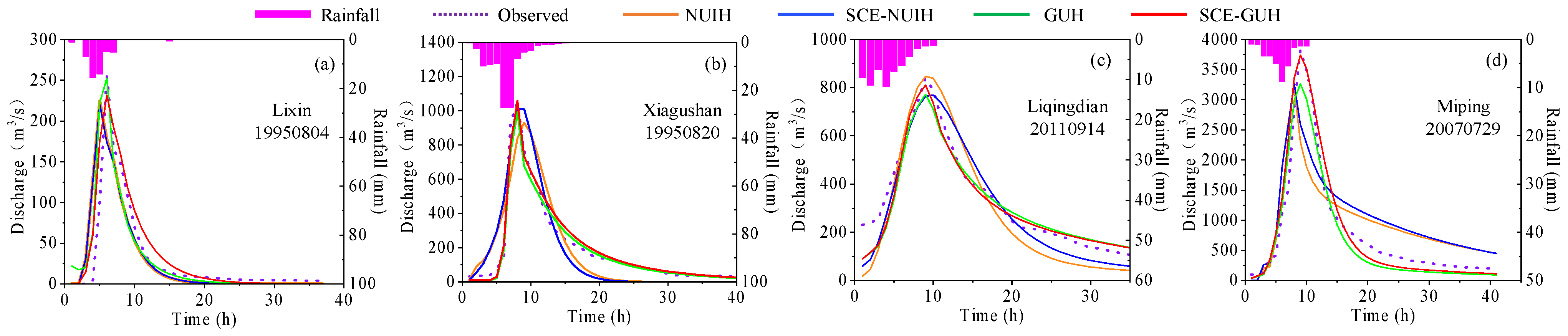
- Lixin watershed: Located within the Huaihe River Basin of China, it covers an area of 79 km2 (113°36′–113°46′ E, 32°86′–32°98′ N). The watershed experiences a continental monsoon climate, characterized by hot and rainy summers, and a humid climate. The average annual precipitation is 960 mm. Land use analysis reveals that farmland and grassland dominate the area, accounting for 39.51% each, followed by forest land at 14.81%.
- Xiagushan watershed: Located within the Huaihe River Basin of China, it covers an area of 383.5 km2 (112°28′–112°43′ E, 33°48′–34°00′ N). The watershed experiences a warm temperate continental monsoon climate with four distinct seasons and abundant rainfall, averaging 1000 mm annually. Land use analysis reveals that the largest proportion of land is dedicated to farmland (45.50%), followed by grassland (41.64%) and forest land (9.51%).
- Liqingdian watershed: Located within the Yangtze River Basin of China, it covers an area of 634 km2 (112°06′–112°31′ E, 33°27′–33°44′ N). The watershed exhibits distinct features of transitioning from a subtropical to warm temperate zone, with precipitation concentrated in the summer. It has an average annual precipitation of 868.8 mm. The largest proportion of land use in the watershed is grassland (73.63%), followed by farmland (18.97%) and forest land (4.01%).
- Miping watershed: Located within the Yangtze River Basin of China, it covers an area of 1402.8 km2 (110°49′–111°29′ E, 33°34′–33°59′ N). The watershed experiences a warm temperate continental monsoon climate with mild weather conditions, four distinct seasons, and moderate rainfall. It has an average annual rainfall of 830 mm. Land use analysis shows that grassland accounts for the largest proportion (90.52%), followed by farmland (7.86%) and forest land (2.41%).
2.2. Data Processing
2.3. Methods
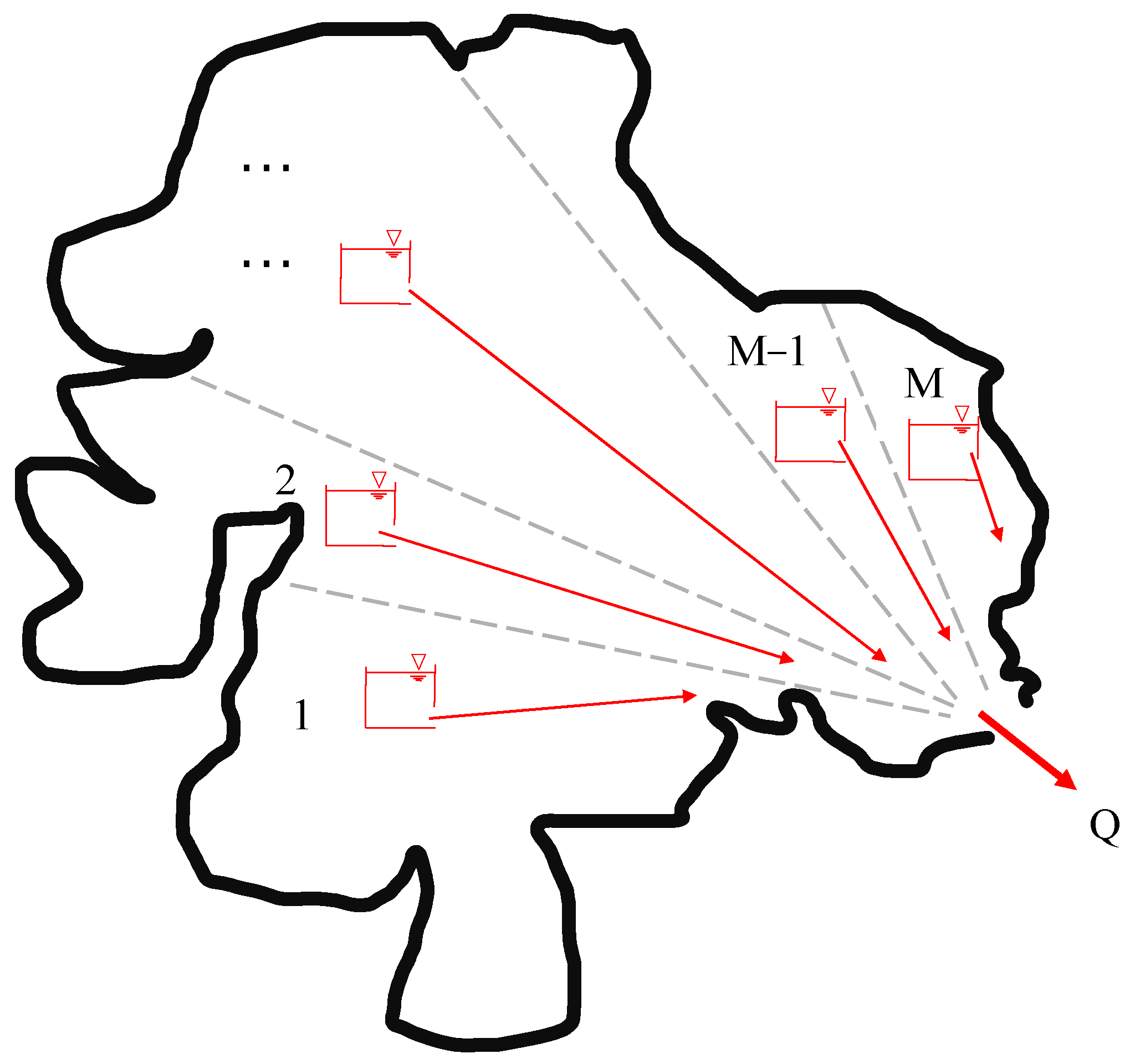
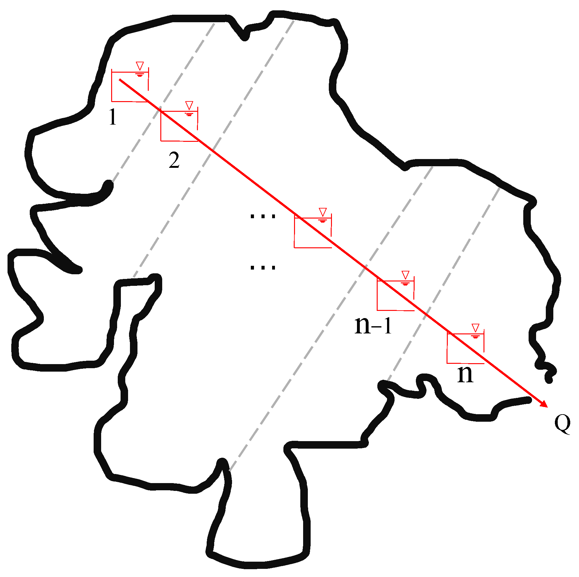
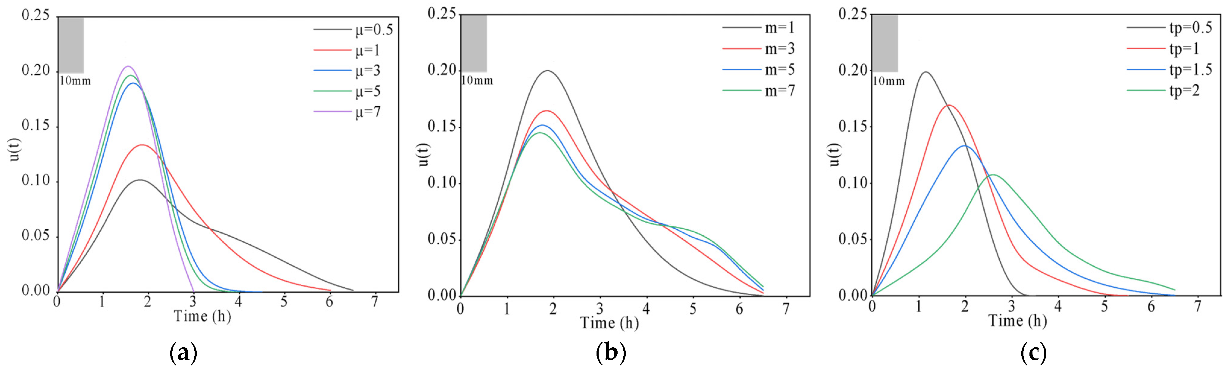
2.3.1. General Unit Hydrograph
2.3.2. SCE-UA Algorithm
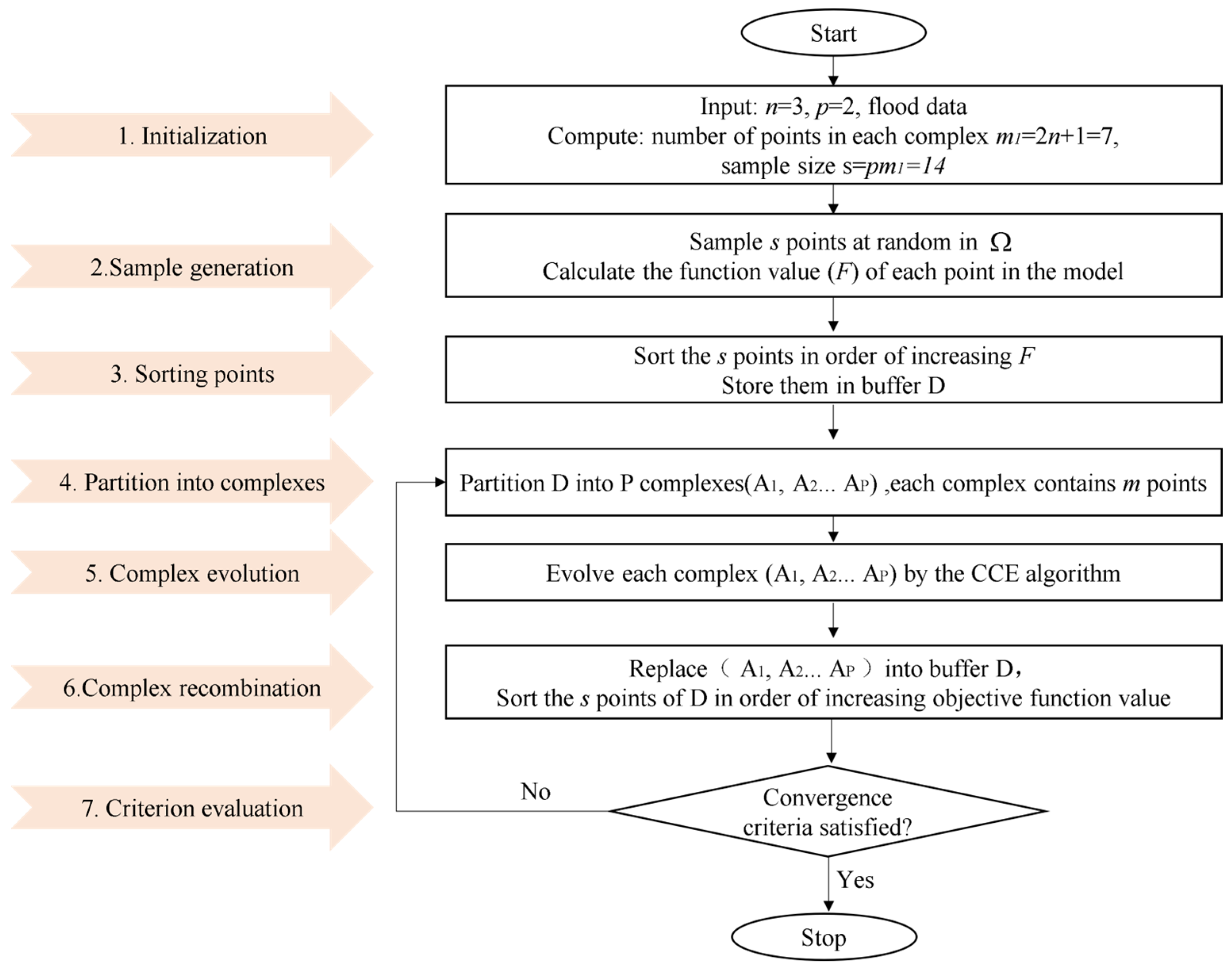
- Initialization: Set the dimensionality of the problem, “p” (value = 2); the value of “n” is 3 in the calculation process using the general unit hydrograph method, which involves only three parameters: , , ; “m1” (value = 7); “s” (value = 14).
- Sample generation: Randomly generate s sample points within the feasible parameter space and compute the criterion value F for each point. F comprises four components: denotes the Nash efficiency coefficient function; represents the determination coefficient function; corresponds to the absolute error function; and symbolizes the peak time difference function.
- Sorting points: Arrange the s points in descending order based on their criterion values, with the first point corresponding to the maximum F value and the last point representing the F value (in the study, the maximum value is considered as the objective function).
- Partition into complexes: Divide the s points into p complexes, where each complex contains m points.
- Complex evolution: Evolve each complex using the competitive complex evolution (CCE) algorithm.
- Complex recombination: Merge the points from the evolved complexes into a sample population; sort this population in ascending order of F.
- Criterion evaluation: If the termination criteria are satisfied, stop; otherwise, go to Step 4. The convergence criteria for the optimization process are as follows: the iteration terminates when the objective function F attains the maximum allowable value or when the rate of change satisfies the specified minimum ratio (0.01%), indicating convergence.
2.3.3. SCE-GUH Model
2.3.4. Model Benchmarks and Methods
2.3.5. Selection of Evaluation Indicators
3. Results
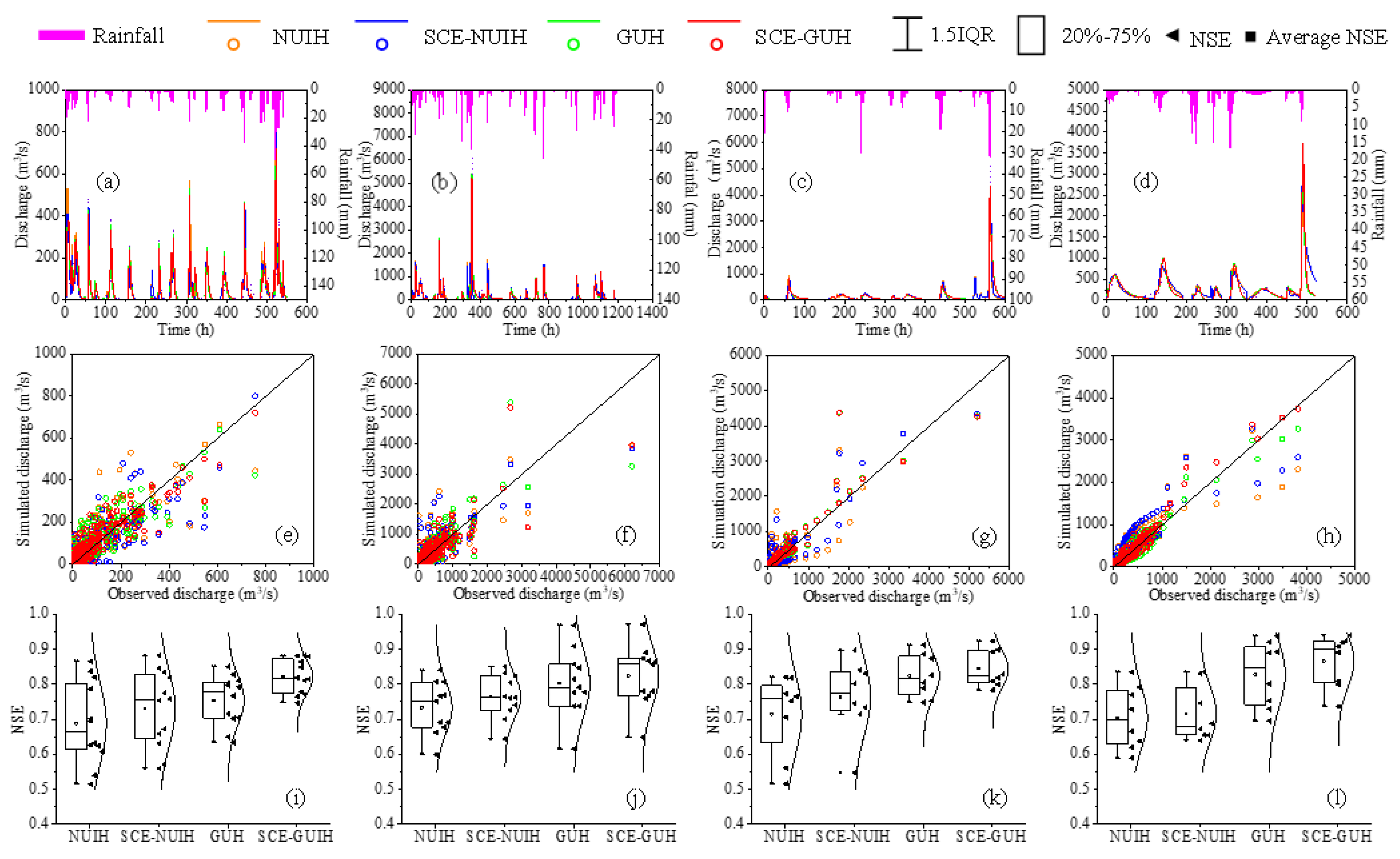
3.1. Model Calibration and Validation Results
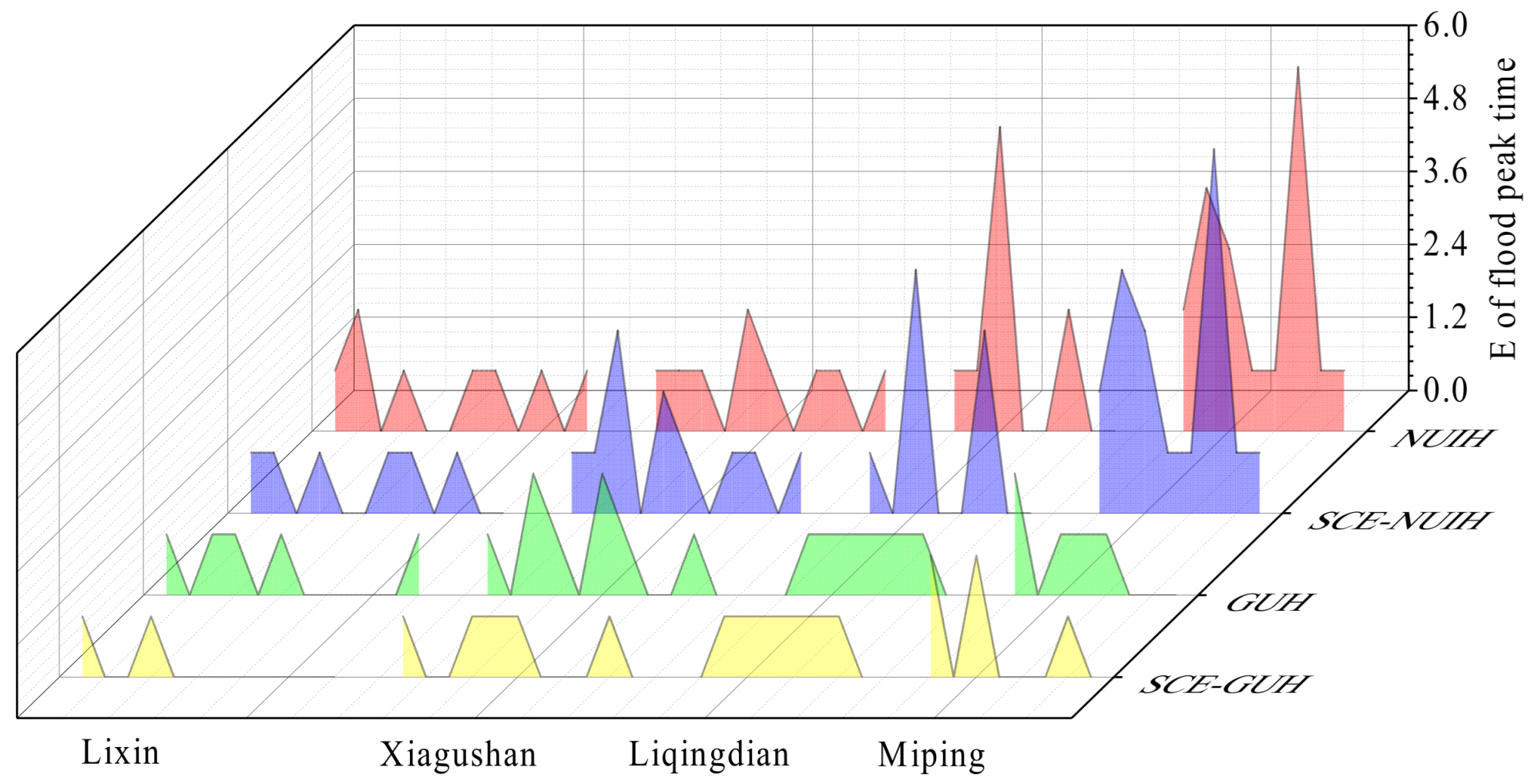
3.2. Typical Site Flood Analysis
3.3. Analysis of the Influence of Parameters on Unit Hydrograph
4. Discussion
5. Conclusions
Author Contributions
Funding
Data Availability Statement
Acknowledgments
Conflicts of Interest
References
- Zhang, Z. Characteristics of flash floods in China and their prevention and control ideas. China Water Resour. 2007, 14, 14–15. [Google Scholar]
- Liu, C.; Guo, L.; Ye, L.; Zhang, S.; Zhao, Y.; Song, T. A review of advances in China’s flash flood early-warning system. Nat. Hazards 2018, 92, 619–634. [Google Scholar] [CrossRef] [Green Version]
- Tamm, O.; Saaremäe, E.; Rahkema, K.; Jaagus, J.; Tamm, T. The intensification of short-duration rainfall extremes due to climate change—Need for a frequent update of intensity–duration–frequency curves. Clim. Serv. 2023, 30, 100349. [Google Scholar] [CrossRef]
- Li, B.; Liang, Z.; Fu, Y.; Wang, J.; Hu, Y. A model for production and sink flow based on variable saturation zone and its parameter determination method. Adv. Water Sci. 2022, 33, 208–218. [Google Scholar]
- Corral, C.; Berenguer, M.; Sempere-Torres, D.; Poletti, L.; Silvestro, F.; Rebora, N. Comparison of two early warning systems for regional flash flood hazard forecasting. J. Hydrol. 2019, 572, 603–619. [Google Scholar] [CrossRef] [Green Version]
- Usman, M.; Ndehedehe, C.E.; Farah, H.; Ahmad, B.; Wong, Y.; Adeyeri, O.E. Application of a Conceptual Hydrological Model for Streamflow Prediction Using Multi-Source Precipitation Products in a Semi-Arid River Basin. Water 2022, 14, 1260. [Google Scholar] [CrossRef]
- Georgakakos, K.P. Analytical results for operational flash flood guidance. J. Hydrol. 2006, 317, 81–103. [Google Scholar] [CrossRef]
- Ntelekos, A.A.; Georgakakos, K.P.; Krajewski, W.F. On the uncertainties of flash flood guidance: Toward probabilistic forecasting of flash floods. J. Hydrometeorol. 2006, 7, 896–915. [Google Scholar] [CrossRef]
- Tamm, O.; Kokkonen, T.; Warsta, L.; Dubovik, M.; Koivusalo, H. Modelling urban stormwater management changes using SWMM and convection-permitting climate simulations in cold areas. J. Hydrol. 2023, 622, 129656. [Google Scholar] [CrossRef]
- He, B. Overview of flash flood warning methods of the Japan Meteorological Agency. China Flood Control Drought Relief 2020, 30, 149–152. [Google Scholar]
- Bartholmes, J.C.; Thielen, J.; Ramos, M.H.; Gentilini, S. The european flood alert system EFAS—Part 2: Statistical skill assessment of probabilistic and deterministic operational forecasts. Hydrol. Earth Syst. Sci. 2009, 13, 141–153. [Google Scholar] [CrossRef] [Green Version]
- Thielen, J.; Bartholmes, J.; Ramos, M.H.; de Roo, A. The European Flood Alert System—Part 1: Concept and development. Hydrol. Earth Syst. Sci. 2009, 13, 125–140. [Google Scholar] [CrossRef] [Green Version]
- Cheng, W. A review of critical rainfall research on flash floods. Adv. Water Sci. 2013, 24, 901–908. [Google Scholar]
- Guo, L.; Tang, X.; Kong, F. Research and application of flash flood early warning and forecasting system based on distributed hydrological model. China Water Resour. 2007, 14, 38–41. [Google Scholar]
- Liu, Z.; Martina, M.L.; Todini, E. Flood forecasting using a fully distributed model: Application of the TOPKAPI model to the Upper Xixian catchment. Hydrol. Earth Syst. Sci. 2005, 9, 347–364. [Google Scholar] [CrossRef] [Green Version]
- Koren, V.; Reed, S.; Smith, M.; Zhang, Z.; Seo, D.J. Hydrology Laboratory Research Modeling System (HL-RMS) of the US National Weather Service. J. Hydrol. 2004, 291, 297–318. [Google Scholar] [CrossRef] [Green Version]
- Rui, X. Stochastic production and convergence theory. Adv. Water Resour. Hydropower Sci. Technol. 2016, 36, 8–12+39. [Google Scholar]
- Ghumman, A.R.; Khan, Q.U.; Hashmi, H.N.; Ahmad, M.M. Comparison of Clark, Nash Geographical Instantaneous Unit Hydrograph Models for Semi Arid Regions. Water Resour. 2014, 41, 364–371. [Google Scholar] [CrossRef]
- Zhu, C.; Wang, X.; Dai, X. Calculate Sherman unit hydrograph by stepwise filter optimization method. J. Hydroelectr. Eng. 2015, 34, 1–6. [Google Scholar]
- Ge, W.; Chen, C. A review of unit line-based confluence studies: A review of Huang Wanli’s ”transient process line”. Water Sci. Econ. 2021, 27, 24–27. [Google Scholar]
- Agirre, U.; Goni, M.; Lopez, J.J.; Gimena, F.N. Application of a unit hydrograph based on subwatershed division and comparison with Nash’s instantaneous unit hydrograph. Catena 2005, 64, 321–332. [Google Scholar] [CrossRef]
- Babaali, H.R.; Sabzevari, T.; Ghafari, S. Development of the Nash instantaneous unit hydrograph to predict subsurface flow in catchments. Acta Geophys. 2021, 69, 1877–1886. [Google Scholar] [CrossRef]
- Lee, K.T. Generating design hydrographs by DEM assisted geomorphic runoff simulation: A case study. J. Am. Water Resour. Assoc. 1998, 34, 375–384. [Google Scholar] [CrossRef]
- Rui, X.; Jiang, G. Some advances and comments on the theory and computational methods of basin confluence. Water Resour. Hydropower Technol. 1997, 9, 43–45. [Google Scholar]
- Lai, P.; Xia, C. Variable-velocity geomorphic unit lines. J. Hefei Univ. Technol. Nat. Sci. Ed. 1989, 2, 102–112. [Google Scholar]
- Yan, B.; Duan, M.; Jiang, H.; Li, Z.; Yang, W.; Zhang, J. Study on catchment confluence model based on fractional instantaneous unit line. Peoples Changjiang 2020, 51, 84–88. [Google Scholar]
- Yi, B.; Chen, L. Time-varying distributed unit lines considering dynamic sink paths. Adv. Water Sci. 2022, 33, 944–954. [Google Scholar]
- Guo, J. General Unit Hydrograph from Chow’s Linear Theory of Hydrologic Systems and Its Applications. J. Hydrol. Eng. 2022, 27, 04022020. [Google Scholar] [CrossRef]
- Guo, J. Application of General Unit Hydrograph Model for Baseflow Separation from Rainfall and Streamflow Data. J. Hydrol. Eng. 2022, 27, 04022027. [Google Scholar] [CrossRef]
- Guo, J. General and Analytic Unit Hydrograph and Its Applications. J. Hydrol. Eng 2022, 27, 04021046. [Google Scholar] [CrossRef]
- Guo, J. Design Hydrographs in Small Watersheds from General Unit Hydrograph Model and NRCS-NOAA Rainfall Distributions. J. Hydrol. Eng. 2023, 28, 5942. [Google Scholar] [CrossRef]
- Chen, R.; Kang, E.; Yang, J.; Zhang, J. A review of hydrological modeling studies. Chin. Desert 2003, 18, 15–23. [Google Scholar]
- Hou, D.; Zhang, X.; Wu, Q.; Li, Z.; Wang, L.; Zhang, L. Construction and application of a flash flood forecasting model based on runoff coefficients. Hydropower Energy Sci. 2022, 40, 83–86. [Google Scholar]
- Ren, B.; Liang, J.; Yan, B.; Lei, X.; Fu, W.; Ni, X.; Guo, J. Parameter Optimization of Double-Excess Runoff Generation Model. Pol. J. Environ. Stud. 2018, 27, 809–817. [Google Scholar] [CrossRef] [PubMed]
- Duan, Q.; Sorooshian, S.; Gupta, V.K. Optimal use of the SCE-UA global optimization method for calibrating watershed models. J. Hydrol. 1994, 158, 265–284. [Google Scholar] [CrossRef]
- Duan, Q.Y.; Sorooshian, S.; Gupta, V. Effective and Efficient Global Optimization for Conceptual Rainfall-Runoff Models. Water Resour. Res. 1992, 28, 1015–1031. [Google Scholar] [CrossRef]
- Jeon, J.-H.; Park, C.-G.; Engel, B.A. Comparison of Performance between Genetic Algorithm and SCE-UA for Calibration of SCS-CN Surface Runoff Simulation. Water 2014, 6, 3433–3456. [Google Scholar] [CrossRef] [Green Version]
- Kang, T.; Lee, S. Modification of the SCE-UA to Include Constraints by Embedding an Adaptive Penalty Function and Application: Application Approach. Water Resour. Manag. 2014, 28, 2145–2159. [Google Scholar] [CrossRef]
- Huang, L.; Wang, L.; Zhang, Y.; Xing, L.; Hao, Q.; Xiao, Y.; Yang, L.; Zhu, H. Identification of Groundwater Pollution Sources by a SCE-UA Algorithm-Based Simulation/Optimization Model. Water 2018, 10, 193. [Google Scholar] [CrossRef] [Green Version]
- Li, X.; Cheng, C.; Wu, X.; Lin, J. Research on fuzzy multi-objective SCE-UA parameter preference method for hydrological models. China Eng. Sci. 2007, 3, 52–57. [Google Scholar]
- Boufadel, M.C. Unit hydrographs derived from the Nash model. J. Am. Water Resour. Assoc. 1998, 34, 167–177. [Google Scholar] [CrossRef]
- Xing, Z.; Wang, L.; Wang, X.; Fu, Q.; Ji, Y.; Li, H.; Liu, Y. The Study on Equifinality of Hydrological Model Parameters and Runoff Simulation Based on the Improved Simulation-optimization Algorithm. J. Basic Sci. Eng. 2020, 28, 1091–1107. [Google Scholar]
- Yue, S. A bivariate gamma distribution for use in multivariate flood frequency analysis. Hydrol. Process. 2001, 15, 1033–1045. [Google Scholar] [CrossRef]
- Sun, Y.; Rui, X. Study of Nash unit hydrograph based on random theory. Water Resour. Power 2005, 23, 18–20. [Google Scholar]
- Li, Y.; Wang, G.; Liu, C.; Lin, S.; Guan, M.; Zhao, X. Improving Runoff Simulation and Forecasting with Segmenting Delay of Baseflow from Fast Surface Flow in Montane High-Vegetation-Covered Catchments. Water 2021, 13, 196. [Google Scholar] [CrossRef]
- Turkyilmazoglu, M. Accelerating the convergence of Adomian decomposition method (ADM). J. Comput. Sci. 2019, 31, 54–59. [Google Scholar] [CrossRef]


| Watershed | SCE-GUH | SCE-NIUH | |||
|---|---|---|---|---|---|
| m | tp/h | μ | n | k | |
| Lixin | 1.60 | 0.96 | 2.18 | 1.61 | 3.32 |
| Xiagushan | 1.90 | 0.60 | 0.20 | 1.86 | 3.74 |
| Liqingdian | 6.70 | 2.10 | 2.50 | 2.53 | 3.11 |
| Miping | 1.00 | 2.00 | 1.50 | 2.79 | 4.40 |
| Basin | RE/% | Nse | R2 | △t/h | ||||||||||||
|---|---|---|---|---|---|---|---|---|---|---|---|---|---|---|---|---|
| NUIH | SCE-NUIH | GUH | SCE-GUH | NUIH | SCE-NUIH | GUH | SCE-GUH | NUIH | SCE-NUIH | GUH | SCE-GUH | NUIH | SCE-NUIH | GUH | SCE-GUH | |
| Lixin | 14.21 | 17.30 | 9.70 | 11.35 | 0.69 | 0.73 | 0.75 | 0.82 | 0.73 | 0.74 | 0.79 | 0.85 | 0.67 | 0.50 | 0.42 | 0.17 |
| Xiagushan | 14.33 | 15.72 | 8.55 | 8.40 | 0.73 | 0.76 | 0.80 | 0.82 | 0.75 | 0.83 | 0.84 | 0.85 | 0.82 | 1.00 | 0.73 | 0.45 |
| Liqingdian | 12.13 | 12.52 | 13.35 | 12.60 | 0.71 | 0.76 | 0.82 | 0.84 | 0.79 | 0.86 | 0.87 | 0.87 | 1.13 | 1.00 | 0.75 | 0.75 |
| Miping | 13.70 | 16.78 | 8.21 | 5.54 | 0.70 | 0.72 | 0.83 | 0.87 | 0.75 | 0.79 | 0.93 | 0.95 | 2.38 | 2.38 | 0.63 | 0.63 |
| Number | RE/% | Nse | R2 | △t/h | ||||||||||||
|---|---|---|---|---|---|---|---|---|---|---|---|---|---|---|---|---|
| NUIH | SCE-NUIH | GUH | SCE-GUH | NUIH | SCE-NUIH | GUH | SCE-GUH | NUIH | SCE-NUIH | GUH | SCE-GUH | NUIH | SCE-NUIH | GUH | SCE-GUH | |
| Lixin watershed | ||||||||||||||||
| 20030830 | −2.22 | −15.76 | −5.83 | 1.19 | 0.89 | 0.93 | 0.92 | 0.94 | 0.93 | 0.95 | 0.95 | 0.96 | 0 | 0 | 0 | 0 |
| 20050708 | 10.47 | 13.33 | 8.19 | 11.42 | 0.79 | 0.94 | 0.82 | 0.87 | 0.84 | 0.88 | 0.88 | 0.90 | 0 | 0 | 0 | 0 |
| 20080722 | 10.39 | −15.23 | −12.23 | −5.54 | 0.54 | 0.72 | 0.77 | 0.83 | 0.70 | 0.77 | 0.82 | 0.85 | −1 | −1 | −1 | −1 |
| 2010019 | 7.71 | −14.30 | −16.21 | −16.14 | 0.73 | 0.78 | 0.81 | 0.86 | 0.81 | 0.85 | 0.88 | 0.89 | 0 | 0 | 0 | 0 |
| Average | 7.70 | 14.66 | 10.62 | 8.57 | 0.73 | 0.82 | 0.83 | 0.87 | 0.82 | 0.86 | 0.88 | 0.90 | 0.25 | 0.25 | 0.25 | 0.25 |
| Xiagushan watershed | ||||||||||||||||
| 20000714 | −85.90 | −57.85 | −25.88 | −18.66 | 0.52 | 0.61 | 0.59 | 0.60 | 0.62 | 0.65 | 0.62 | 0.63 | 0 | 0 | −1 | 1 |
| 20020626 | −4.30 | −16.26 | 0.20 | 6.99 | 0.62 | 0.78 | 0.91 | 0.95 | 0.65 | 0.79 | 0.92 | 0.96 | −1 | −1 | 0 | 0 |
| 20100718 | −0.84 | −17.95 | −7.24 | −11.38 | 0.66 | 0.67 | 0.89 | 0.91 | 0.70 | 0.69 | 0.89 | 0.92 | 0 | 0 | 0 | 0 |
| 20130525 | −1.62 | 3.50 | 1.87 | 5.53 | 0.71 | 0.79 | 0.86 | 0.89 | 0.72 | 0.79 | 0.86 | 0.89 | 3 | 3 | 0 | 0 |
| Average | 23.17 | 23.89 | 8.80 | 10.64 | 0.63 | 0.71 | 0.81 | 0.84 | 0.67 | 0.73 | 0.82 | 0.85 | 1 | 1 | −0.25 | 0.25 |
| Liqingdian watershed | ||||||||||||||||
| 20100819 | −23.99 | −17.58 | 0.77 | 1.28 | 0.62 | 0.59 | 0.72 | 0.73 | 0.72 | 0.63 | 0.76 | 0.76 | 1 | 1 | −1 | 1 |
| 20100823 | 4.46 | 10.23 | 3.95 | 6.23 | 0.70 | 0.76 | 0.77 | 0.81 | 0.79 | 0.85 | 0.82 | 0.84 | 3 | 0 | −3 | 3 |
| 20110914 | 1.02 | 8.92 | −8.55 | −3.35 | 0.80 | 0.88 | 0.93 | 0.94 | 0.88 | 0.94 | 0.95 | 0.95 | 0 | 1 | 0 | 0 |
| Average | 9.82 | 12.24 | 4.42 | 3.62 | 0.71 | 0.74 | 0.80 | 0.83 | 0.8 | 0.81 | 0.84 | 0.85 | 1.33 | 0.67 | 1.33 | 1.33 |
| Miping watershed | ||||||||||||||||
| 20090816 | −17.62 | −19.04 | −12.74 | −7.06 | 0.54 | 0.55 | 0.86 | 0.85 | 0.73 | 0.75 | 0.86 | 0.87 | 3 | 1 | −1 | −1 |
| 20100724 | −7.81 | −2.60 | −7.69 | −4.86 | 0.79 | 0.83 | 0.88 | 0.88 | 0.89 | 0.89 | 0.89 | 0.89 | −1 | −1 | 2 | 2 |
| 20110913 | 0.81 | 4.62 | −3.13 | 1.59 | 0.75 | 0.82 | 0.92 | 0.91 | 0.84 | 0.87 | 0.93 | 0.93 | 1 | 1 | 1 | −1 |
| Average | 8.75 | 8.75 | 7.85 | 4.50 | 0.69 | 0.73 | 0.89 | 0.88 | 0.82 | 0.84 | 0.89 | 0.90 | 1.67 | 1 | 1.33 | 1.33 |
Disclaimer/Publisher’s Note: The statements, opinions and data contained in all publications are solely those of the individual author(s) and contributor(s) and not of MDPI and/or the editor(s). MDPI and/or the editor(s) disclaim responsibility for any injury to people or property resulting from any ideas, methods, instructions or products referred to in the content. |
© 2023 by the authors. Licensee MDPI, Basel, Switzerland. This article is an open access article distributed under the terms and conditions of the Creative Commons Attribution (CC BY) license (https://creativecommons.org/licenses/by/4.0/).
Share and Cite
Xu, Y.; Liu, C.; Yu, Q.; Zhao, C.; Quan, L.; Hu, C. Study on a Hybrid Hydrological Forecasting Model SCE-GUH by Coupling SCE-UA Optimization Algorithm and General Unit Hydrograph. Water 2023, 15, 2783. https://doi.org/10.3390/w15152783
Xu Y, Liu C, Yu Q, Zhao C, Quan L, Hu C. Study on a Hybrid Hydrological Forecasting Model SCE-GUH by Coupling SCE-UA Optimization Algorithm and General Unit Hydrograph. Water. 2023; 15(15):2783. https://doi.org/10.3390/w15152783
Chicago/Turabian StyleXu, Yingying, Chengshuai Liu, Qiying Yu, Chenchen Zhao, Liyu Quan, and Caihong Hu. 2023. "Study on a Hybrid Hydrological Forecasting Model SCE-GUH by Coupling SCE-UA Optimization Algorithm and General Unit Hydrograph" Water 15, no. 15: 2783. https://doi.org/10.3390/w15152783