Article

Water-Level Fluctuations and Ungulate Community Dynamics in Central Uganda

by
Camille H. Warbington
* and
Mark S. Boyce
Department of Biological Sciences, University of Alberta, Edmonton, AB T6G 2E9, Canada
*
Author to whom correspondence should be addressed.
Water 2023, 15(15), 2765; https://doi.org/10.3390/w15152765
Submission received: 25 June 2023 / Revised: 19 July 2023 / Accepted: 27 July 2023 / Published: 30 July 2023

Abstract

:
Climate change has altered precipitation regimes with concomitant influences in hydrology. For a complex assemblage of ungulates, these water-level fluctuations might alter habitat partitioning thought to be crucial for coexistence in response to livestock introduction. We placed camera traps in three habitat types along the Mayanja River in central Uganda to evaluate space use by native and domestic ungulates. For each species, we assessed the difference in the proportion of days with camera-trap detections during three water-level conditions (low in 2017, normal in 2015, and high in 2016). Sitatunga was the only species regularly using wetlands; their use of remote wetlands remained consistent regardless of water-level conditions, and their use of forest habitats decreased during the study. In the forest, warthogs showed no change in use, while proportion of days with detections increased over time for all other ungulates. Our results indicate that ungulate community space use appears to be independent of hydrologic condition, and that risk for competitive exclusion between native and domestic ungulates is tempered by dietary and habitat use differences. Adaptations to dynamic hydrology appears to buffer consequences for ungulate communities; more serious are habitat losses to agriculture and development.

1. Introduction

The Intergovernmental Panel on Climate Change (IPCC) predicts new hot climates in the tropics, and that extreme weather will increase in frequency and severity [1]. Specific changes in temperature and severe weather are unpredictable [2,3], but wetland water provisioning—the timing and volume of water in the system—will be altered. Wetlands—papyrus (Cyperus papyrus L.) marshes in particular—buffer against droughts and severe rain events brought about by shifting weather patterns [2,4,5,6], but wetland ecosystem services will themselves be affected by these same events [2].
Wetlands cover only 6% of the world’s land surface, yet they and associated floodplains are among the most-altered landscapes worldwide [2,7]. Wetlands, defined here as ecosystems characterized by inundation at the terrestrial-aquatic interface [8], are important to well-being, providing benefits such as habitats, carbon sinks, flood control, peat, and fibre production [9]. Developing countries have a large proportion of people dependent upon livelihoods involving subsistence agriculture and wetland resources [10]. In East Africa, small wetlands are increasingly converted to agricultural production, both for croplands and livestock [11,12]. Anthropogenic effects are expected to rise—in Uganda, the human population is projected to be over 48 million by 2025 [13]. Increase of human population will increase the area of wetlands supporting agricultural production and other extractive uses, such as brickmaking [14,15]. Previous research has shown that communities living alongside wetlands recognize their value, but that people increase their use of wetland resources and space for cultivation in the absence of regulation and enforcement [16]. Even though the value of multifunctional wetlands exceeds the value of wetlands converted to agriculture, humans living close to wetlands will exacerbate encroachment [4,14].
In addition to providing ecosystem services to humans, wetlands and riverine floodplains support high biological diversity [2]. In Africa, the high diversity of large ungulates carries over into wetlands [17]. To offset potential competition, species differ in preferred habitats, food items (e.g., grazers or browsers), or time of activity (e.g., diel or seasonal scales) [18]. Among the large mammal community in central Uganda, three species associate strongly with floodplain habitats, but differ in terms of specific preferred habitats and/or diet. Waterbuck (Kobus ellipsiprymnus Ogilby 1833) are habitat generalists but associate with permanent water, and their diet is classified as a combination of grazer-browser [19,20]. Hippopotamus (Hippopotamus amphibius Linnaeus, 1758) are intermediate in habitat preferences—they rely on water but require grasslands for grazing [21]. Sitatunga (Tragelaphus spekii Speke, 1863) are most closely associated with wetlands, having specialized adaptations such as elongated hooves for walking on marsh vegetation, and are classified as selective mixed feeders [22]. Thus, waterbuck, hippopotamus, and sitatunga have different preferred habitats and food, which facilitates coexistence.
While generalized preferences suggest mechanisms for coexistence, it remains unknown how habitat preferences change under varying conditions within the floodplain, such as flood or drought. Previous research illustrates that ungulate space use within floodplains and forests along rivers can change depending on rainfall and season, though specific effects vary [23,24,25,26]. Changes in space use can affect ungulate community composition, leading to changes in species interactions; ungulate species that do not specifically rely on wetlands or floodplains may use them intermittently for resources, especially if preferred forage is unavailable [23,27]. Similarly, previous work shows that sitatunga will forage in dry-land habitats close to swamps and marshes [28], but use of dry land could increase during drought or flood conditions, potentially increasing space-use conflict with other ungulates. Competition for resources is greatest when resources are low, leading to competitive exclusion [29]. Habitat specialist animals, such as sitatunga, face greater risk of extinction due to climate change compared to habitat generalists such as waterbuck, even when subjected to the same conditions in the same ecosystem [30].
Wetlands in central Uganda are affected by changes in land use and water provisioning. Agricultural land uses, including livestock production, are increasing, wetlands are decreasing, and average annual rainfall decreased 12% over the past 34 years, with the greatest decline in agricultural regions, including central Uganda [31,32,33]. Changes in land use and water provisioning could affect ungulate space use within floodplains. The expected native ungulate assemblage in wetlands and floodplains of central Uganda differs in food and habitat preferences, but specific habitat use within the floodplain is relatively unknown (Table 1) [21,22,34,35,36]. Also unknown is if habitat use changes during different conditions in the wetland, such as flood or drought. If drought causes forage reduction, then species without strong ecological ties to wetlands and water, such as bushbuck (Tragelaphus scriptus Pallas, 1766), could increase use of wetland in search of adequate forage during droughts. Use of wetlands by non-specialist species might be restricted to areas directly adjacent to dry-land habitats, compared to interior wetlands that are more difficult to access without specialized adaptations. Alternatively, wetland flooding could encourage sitatunga, waterbuck, and/or hippopotamus to increase use of dry-land habitats, while drought conditions encourage these species to decrease use of dry land [22]. The presence of domestic cattle (Bos taurus Linnaeus, 1758), a novel competitor, also could affect space use by native ungulates. Cattle have the same food preferences as native ungulate grazers hippopotamus and warthog (Phacochoerus africanus Gmelin, 1788) [21,37], thus they likely use the same grazing areas. If cattle space use is chosen by humans who tend the herds, then it would be unlikely to find cattle in remote, permanently flooded wetlands [11]. However, wetland specialist sitatunga can avoid cattle by maintaining use of remote wetland habitats regardless of condition, and other native ungulates could increase use of remote wetlands during droughts, when forage on dry land is reduced.
While past studies regarding agricultural use of wetlands in Africa have focused on wetland loss to crop production, we are not aware of any that investigated the effects of cattle production on wetland wildlife. From 2015–2017, the Mayanja River area of central Uganda experienced drastically different water levels, including flood conditions and a severe drought leading to a wildfire within the wetland. Because of the divergent river conditions experienced and the presence of domestic cattle, this ecosystem was an ideal location, duration, and ungulate assemblage on which to test hypotheses about cattle and native ungulate species space use in and around wetlands under varying hydrologic conditions. To assess space use of native and domestic ungulates in various habitats and hydrologic conditions, we used a camera trap array in central Uganda over three years [41]. We made seven a priori predictions: In forested habitats, for species with strong ecological ties to wetlands or water (hippopotamus, sitatunga, and waterbuck), we predicted that there will be an increase in the proportion of days with detections during high-water conditions (prediction 1F) and a concomitant decrease in the proportion of days with detections during low-water conditions when compared to normal water conditions (prediction 2F); wild ungulates that do not associate strongly with wetlands will not vary in the proportion of days with detections in the forest according to hydrologic conditions (prediction 3F). In wetlands located close to dry land, herein referred to as shoreline wetlands, we predicted that the proportion of days with detections of all ungulate species will increase during low-water conditions due to a reduction in available forage outside of wetlands (prediction 1S). For remote wetlands, herein referred to as river wetlands, we predicted the proportion of days with detections of wetland specialist species sitatunga will remain high regardless of hydrologic conditions (prediction 1R); cattle would not be detected under any condition (prediction 2R); and other wild ungulate species would only be detected during low-water conditions (prediction 3R). Evaluation of these predictions regarding cattle presence and variations in water level will help to unravel mechanisms of species coexistence in and around wetlands under the synergistic effects of livestock production and climate change.

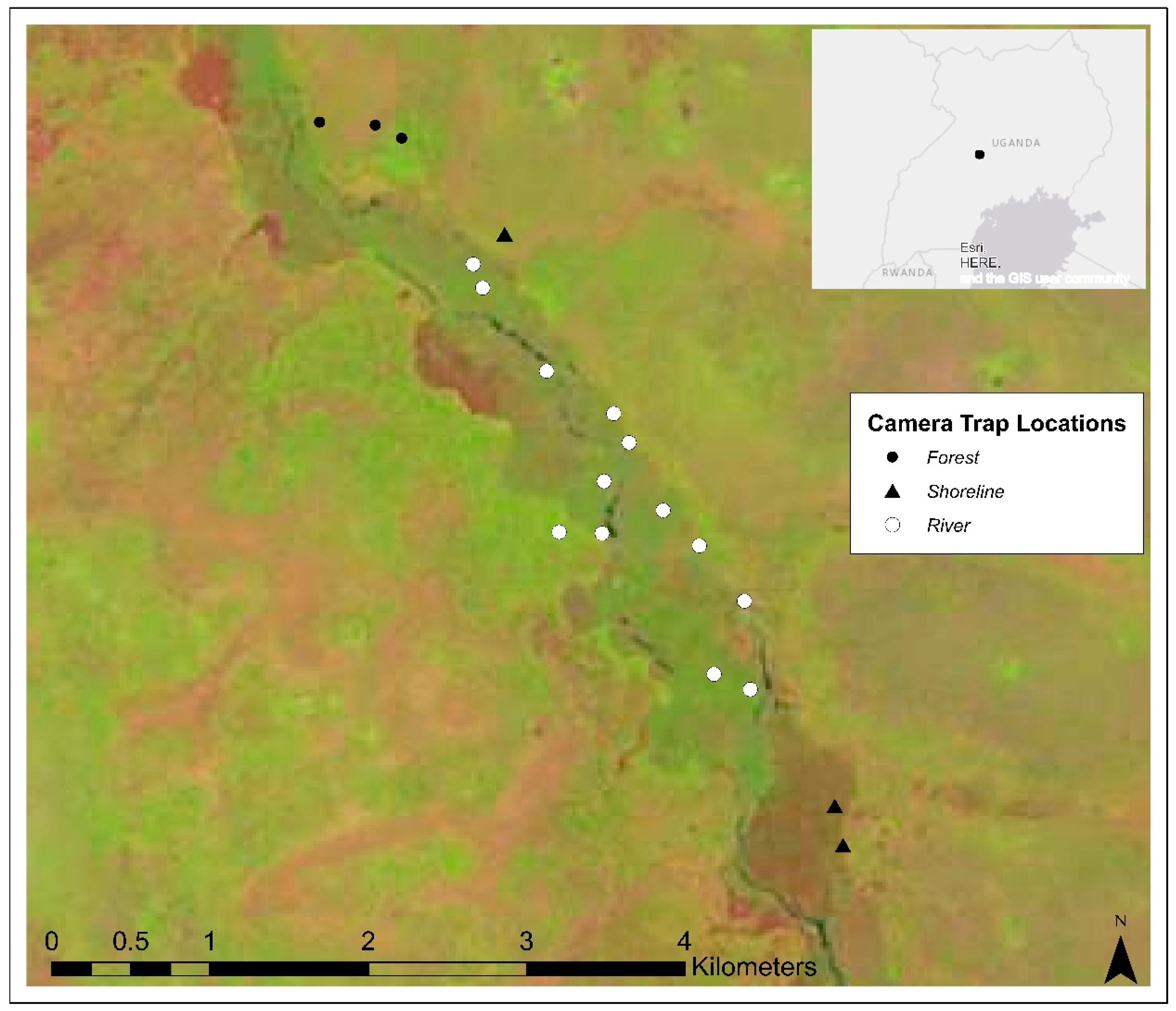
2. Materials and Methods

The study area lies in central Uganda, in the marshes and floodplain forests of the Mayanja River system, which is part of the Nile watershed (Figure 1). In this area, the Mayanja River forms the border between Nakaseke and Kyankwanzi districts in central Uganda. The equatorial Ugandan climate is generally rainy, with two dry seasons, December to February and June to August, although there is local variation in the length, timing, and duration of the dry seasons [42]. In Nakaseke District, the average annual temperature is 22.2 °C, and average annual rainfall is 1282 mm [43]. Country wide, approximately 11% of the land is cultivated [42].
Ungulate species in the study area included hippopotamus, sitatunga, waterbuck, warthog, bushbuck, oribi (Ourebia ourebi Zimmermann, 1783), bohor reed buck (Redunca redunca Pallas, 1767), bushpig (Potamochoerus larvatus F. Cuvier, 1822), and common duiker (Sylvicapra grimmia Linnaeus, 1758). Forests in the study area were comprised of African fan palm (Borassus aethiopum Mart.), acacia (Vachellia spp. Wight & Arn. and Senegalia spp. Raf. 1938), and other bushland species. Papyrus dominated the wetlands in the study area; giant mimosa (Mimosa pigra L.), and various grasses occurred along the wetland/dryland edge, and open water often was colonized by waterlily (Nymphaea L.) (C. Warbington, personal observation). The wetlands within the study area covered approximately 8.1 km2.
During our research, the river level in the study area was markedly higher in 2016 than 2015 (Figure 2). High water remained throughout the 2016 field season, April through August. During high-water levels, formerly intermittently inundated soils became saturated, and formerly dry areas adjacent to the wetland were flooded (C. Warbington, personal observation). In April 2016, culverts under roads crossing the Mayanja River washed away due to high water levels [44]. In 2017, field work began in February, coinciding with the dry season. On the Mayanja River, late 2016 and early 2017 was dryer and hotter than in recent years [45,46] (Figure 3). Due to the dry conditions and adjacent charcoal production, a substantial portion of the wetland burned in late January and early February 2017, in some areas from shoreline to shoreline. Dry conditions also led to a dieback of normal foraging areas for cattle and a change in water access points due to retraction of water within the river channel. In 2017, we observed cattle actively entering unburnt shoreline wetlands to eat papyrus and other plants, and to access water; we had not observed this behaviour in previous years. Fluctuations in water level may not be exclusively from changes in precipitation—from March 2015 through June 2017, construction of a bridge across the Mayanja River took place upstream from the study area, potentially affecting water flow in the river [47]. The variation in water level of the river provided a natural experiment to test hypotheses regarding wildlife and cattle space use during varying wetland conditions.
At the time of our study, no formal hydrological data was available for the Mayanja River; therefore, our observations and local ecological knowledge form the basis of our assessment of low, normal, and high water levels. For comparisons, we defined 2015 as normal-water conditions, 2016 as high water, and 2017 as low-water conditions. To maximize the difference in water level in the Mayanja River, we used observations during peak dry season months in 2017, and peak wet season months in 2016. For 2015 and 2016, observations were constrained to May through August. In 2016, the water level in the river remained high during this time period. In 2017, field observations occurred February through April, after which the papyrus in burned areas had grown to similar height of unburned areas (C. Warbington, personal observation).
We separated the floodplain into three zones. (1) Shoreline: wetlands immediately adjacent to dry land, defined as areas of aquatic vegetation visible from a 2-m tall platform situated on dry land, and we accessed trail cameras placed in this zone directly from dry land. The Shoreline zone is evaluated in regards to prediction 1S. (2) River: wetlands remote from dry land, not visible from platforms on the shore, and trail cameras in this zone were accessed via canoe across or along a main open-water river channel. The River zone is evaluated in regards to predictions 1R, 2R, and 3R. (3) Forests: dry-land habitats, defined as areas of non-inundated soils, devoid of aquatic vegetation, comprised mainly of woody stems and a closed canopy at least 2-m in height. Forest zones were not flooded during the high-water conditions of 2016. The Forest zone is evaluated in regards to predictions 1F, 2F, and 3F. We placed Forest trail cameras within 20 m of wetland edge. Undisturbed papyrus grows in high density; thus, to increase visibility and chance of capturing unobstructed images we placed Shoreline and River trail cameras in papyrus stands cut to ≤20 cm in height by workers using machetes. No bait was used, but we attempted to place all trail cameras in areas with evidence of high use, evidenced by game trails, bedding areas, and wildlife faeces. We used some of the same camera locations in each year of the study; due to changes in accessibility of the wetlands during high and low water conditions, locations of some cameras in the Shoreline and River zone varied between years.
We used Reconyx HyperFire trail cameras with semi-covert infrared flash for nighttime surveillance (Reconyx, Holmen, Wisconsin, WI, USA). We programmed the cameras to take bursts of three pictures at all times when triggered by the motion sensor, with no delay between photographic bursts. We programmed the camera to take a picture at noon every day as verification that the camera was still operational even if there was not a triggering event that day. We visited the cameras approximately every four weeks to change memory cards, replace batteries, and clear the camera site from vegetation encroachment.
We defined a unique encounter as a photographic capture of at least one individual of an identifiable species for a unique date and camera combination. We elected to use the proportion of days with a detection to avoid issues due to differences in detectability, home range size, and other potential sources of bias inherent in other measures [48]. We classified a photographic capture event as “unknown” when not enough of the animal was depicted in the image for identification of species, or when camera malfunction obscured part of the image. The images classified as “unknown” were excluded from analysis. We defined a camera day as a single day that a single camera was deployed and functional. To constrain the test proportions to between zero and one, we defined the numerator as the number of camera days with at least one unique encounter of the species in question, and the denominator is the total number of camera days for a given camera, zone, and hydrologic condition.
Within a species-zone combination, we tested for a difference in proportions between years using the function prop.test, which calculates a modified chi-squared statistic, using program R version 3.5.1 [49]. We compared the calculated p-value to a significance level of 0.05 to test hypotheses. We analysed proportions only when there were at least 4 encounters for 2 of the 3 years of the study. In ecological studies, adjusting probability values for multiple statistical tests, such as a sequential Bonferroni correction, is meant to reduce Type I error, but these adjustments reduce power and increase Type II errors [50,51]. Therefore, we elected to report exact p-values and effect sizes for our tests [50,51]. For each test where p ≤ 0.05, we calculated the effect size using Cohen’s h, the difference in arcsine transformation of the proportions [52]. We report the absolute value of Cohen’s h, and adopt the interpretation that small, medium, and large effect sizes are indicated by h = 0.2, 0.5, and 0.8, respectively [52].
Protocols for animal use were approved by the Animal Care and Use Committee for Biosciences (University of Alberta, Research Ethics Office, protocol AUP00001399).

3. Results

We deployed a total of 27 cameras in 2015 (normal water conditions), 25 in 2016 (high water), and 26 in 2017 (low water levels; Table S1). During low-water conditions (2017), we experienced a series of camera failures in the Shoreline zone. Malfunctions included one camera that took a picture every second until the batteries failed (approximately 3 days after deployment), camera poles falling, insect invasion, and human interference. The camera failures resulted in an artificially low number of days where cameras were deployed and functional in the Shoreline zone, as well as low detections of any animal, resulting in small sample size and corresponding proportions unsuitable for testing. Thus, data for Shoreline wetlands during low water were excluded from analysis, and we were unable to evaluate prediction 1S.
Cameras detected over 20 species of terrestrial vertebrates during the course of the study (Table S2) [53]. Unknown or unidentifiable images constitute <2.5% of all images. In the Forest zone, we met the threshold for detections—4 or more in at least 2 years of the study—for bushbuck, bushpig, cattle, hippopotamus, sitatunga, warthog, and waterbuck. In the Shoreline and River Zones, we met the detections threshold for sitatunga only, supporting predictions 1R and 2R. We detected waterbuck in the River zone in the wet year, and we detected hippopotamus, bushpig, and bushbuck in the dry year, yielding conflicting results for prediction 3R. While we did detect more ungulate species in the River zone during the dry year, we did not meet the threshold of detections in at least two years for any species (Table 2).
We detected cattle only in the Forest (Table 2). Within the Forest zone, the proportion of days with a cattle detection did not differ between normal and high-water years, but the proportion increased during low water (Table 3, Figure 4).
Cameras detected sitatunga in all three zones over the course of the study. However, there were no sitatunga detections in the Forest during the low-water year, partially supporting prediction 2F (Table 2). The proportion of days with a sitatunga detection decreased between normal and high-water conditions in both the Shoreline and the Forest, partially refuting prediction 1F, while staying consistent in the River for all years of the study, supporting prediction 1R (Table 3, Figure 5).
For other species of ungulate in the Forest zone, over the three years of the study we detected increasing proportions of days with a detection of at least one individual for bushbuck, bushpig, hippopotamus, and waterbuck, yielding conflicting results for predictions 1-3F (Table 3, Figure 4). We did not detect any change in the proportion of days with a detection of warthog over the course of the study, 2015–2017, supporting prediction 3F (Figure 4). Of the comparisons with p < 0.05, the majority of the effect sizes were small to medium (h = 0.26–0.66; Table 4). The comparison between 2015 and 2017 for bushbuck in the Forest zone had a large effect size (h = 1.15; Table 4).

4. Discussion

In the Mayanja River area of central Uganda, we expected the ungulate community to alter space use in three habitat types depending on the prevailing hydrologic conditions in the river. Of our a priori predictions, four of seven involved varying use of a vegetation type during a change in hydrologic condition, but our results were mixed and none of these predictions were fully verified (1F, 2F, 1S, and 3R). Our results more fully support the three predictions not involving hydrologic conditions (3F, 1R, and 2R). We were unable to fully evaluate predictions 3R, which involves hydrologic condition, and 1S. We did not detect a strong effect of hydrologic condition, but we did identify partitioning that might contribute to coexistence for this community [18,54]. Equipment failures and temporal limitations of our study, in terms of camera days and only three years of observation, may preclude complete rejection of the effects of hydrology on ungulate niche overlap in this community. While the multiple statistical tests in this study may cause some concern for an increase in Type I error, it is extremely unlikely that all of our results are due to chance [50,51]. The findings of statistical significance for multiple species coupled with the small to medium effect sizes are an indication that something important is happening in this community (Table 4) [51,52]. Multiple ungulate species with and without close ties to water increased their use of forest habitats over time regardless of water level, suggesting that factors other than wetland condition affected space use for this community.
We found the strongest support for our predictions in the River zone. For sitatunga, use of remote River zone wetlands did not vary according to water level, supporting prediction 1R. Sitatunga possess specialized adaptations for life in wetlands, so it is not surprising that permanent wetlands were their preferred habitats [35]. We did not detect cattle in the remote River wetlands during any part of this study, supporting prediction 2R. Therefore, sitatunga did not compete with cattle because sitatunga chose remote River wetlands for foraging. Similarly, sitatunga in remote wetlands also avoided the consequences of cattle grazing, including vegetation trampling and water fouling [6,39]. We recorded more ungulate species using the remote River wetlands during the dry year, supporting prediction 3R, but a lack of detections in previous years precluded statistical comparison (Table 2, Table S2). These results indicate that sitatunga use of wetlands was spatially segregated from the other ungulates in the community, thus reducing any possible effects of competition. We found that our results reiterated the crucial importance of wetlands for management and conservation of sitatunga. Since wetlands both are subject to and buffer against climate extremes, conservation of these habitats should be a priority.
Due to equipment failures, we were unable to analyse space use of Shoreline wetlands during low-water levels and evaluate prediction 1S. Although trail cameras did not record cattle entering the Shoreline zone, we observed cattle entering these areas to eat papyrus and access water but only during 2017. Similarly, we cannot conclude that other ungulates did not use Shoreline wetlands during low water, because detections of native ungulate species increased in the River zone during low water (Table 2, Table S1). Other studies found that wetlands provide grazing grounds during seasons when forage is scarce [11]. Thus, ungulate use of wetlands during dry conditions warrants further investigation to determine the potential consequences of climate change.
Our predictions in the Forest zone were partially supported, precluding conclusions across multiple species. Among species that have close ties to water and wetlands, sitatunga was the only species that decreased in detections during the three years of the study, partially refuting prediction 1F. However, because we did not have forest or other dry-land habitats where cattle were excluded while allowing access for sitatunga, we cannot determine if sitatunga or other species were actively avoiding areas with cattle presence, i.e., dry-land habitats such as forests. Previous studies have found that sitatunga would use dry-land habitats including forests and cropland in addition to wetlands, thus it remains important for future studies to determine if cattle or human encroachment is affecting sitatunga habitat use [39,55]. The other water and wetland-associated species increased in proportion of days with a detection during the three years of the study, but hippopotamus increased in the wet year (supporting prediction 1F) while waterbuck increased in the dry year (refuting both 1F and 2F). Thus, generalizations based on hydrology do not apply across species, even those with strong ecological ties to wetlands and water.
We also obtained conflicting results for species without strong ecological ties to water. While the proportion of days with a detection increased for all species except for warthog, refuting 3F, we can interpret the results as supporting 3F because hydrology likely did not affect the changes we observed. For example, the increase in the proportion of days with bushpig detections in the forest during the low water year could have been due to relief from the heat, or for underground foraging when other resources were scarce [56]. If hydrology does not affect habitat use of riverine forests, then we should consider what other factors contributed to the increase in detections as well as possible partitioning contributing to coexistence for the ungulate community.
Wildlife in the study area are adapting to the presence of cattle as well as other anthropogenic effects. Cattle in our study area are constantly attended by herdsmen, who lead the cattle to water access points, grazing and resting areas, and bomas for protection overnight. Thus, habitat selection and the timing of cattle use of forests is at the discretion of their human caretakers. Over the course of the study, charcoal production led to removal of forest patches along the river, thus changing the layout of habitats that wildlife could use and that herdsmen could choose for cattle (C. Warbington, personal observation). Ungulate use of forests is likely for foraging as well as for shelter from heat stress during the day [57,58]. Human-altered landscapes tend to be hotter and drier than natural vegetation [57]; hotter conditions, smaller and fewer forest patches, well as cattle space use could affect the space use of native ungulates more than the water level in the river [59,60]. Therefore, for the species in our study during the dry year, an increase in the proportion of days with a detection in forests could be caused by the changing availability of other habitats offering thermal cover. For social ungulates, including waterbuck and warthog, cattle production affects group size and composition, perhaps to increase vigilance behaviour in altered landscapes [61]. Larger groups could also contribute to a larger proportion of days with a detection, especially if larger groups are restricted to smaller or fewer habitat patches.
Other herbivore behavioural responses to anthropogenic presence and land-use change could include changing diet and activity patterns, such as to be more active at night [62,63,64]. Since the majority of ungulates in our study increased in proportion of days with a detection over the three years of observation, dietary or temporal activity differences likely facilitate coexistence [18]. A companion study used the same set of camera trapping data to explore diel differentiation for this community [65,66]. Waterbuck and bushbuck showed increased use of forests over time and had high temporal overlap [65,66]. The increase in the proportion of days with waterbuck and bushbuck detections in the dry year mirrors the findings from Dunham (1994); however, we do not expect much dietary overlap except possibly during periods of resource scarcity [25,35,36]. The high daily activity overlap and increased proportion of days with detections in the forests for bushpigs, hippopotamus, and waterbuck are also offset by dietary differences [21,36,56]. Due to dietary overlap, we expect cattle to compete with other grazers, hippopotamus and warthogs, as well as intermediate grazers-browsers, waterbucks (Table 1) [21,34,36,64]. While hippopotamus emerge from the river to graze at night, warthog activity was diurnal, like that for cattle [21,37,65,66] (Table 1). Cattle and hippopotamus thus have low daily temporal overlap, while cattle and warthogs have high overlap. Therefore, cattle and warthogs have a higher likelihood for competition if they use the same habitat and the same forage. However, the proportion of days with warthog detections did not change over the course of our study, likely because forests are not their preferred habitats [37] (Table 1). We cannot completely gauge competition between cattle, hippopotamus, and warthog because surveyed habitats did not include rangeland or grassland where we might expect competition for grazing resources. Due to temporal and dietary overlap, spatial segregation between cattle and warthog might be critical to coexistence.
Projected human population growth in Uganda will increase the amount of anthropogenic disturbance in wetlands and floodplains, thus the impacts of human development on wildlife and habitats must be addressed [13,15,32,67,68]. Human agricultural development in central Uganda has affected the native ungulate community by altering vegetation configuration and by introducing cattle as a novel competitor. Understanding community dynamics in response to flood and drought provides insights into species adaptations to climate and land-use change. Sitatunga were unique in the community with use of wetlands remaining constant over time while use of forest decreased. More investigation is needed to determine if dry-land habitat use is affected by cattle presence, and if species without strong ties to water increase use of wetlands during droughts. Temporal, dietary, or spatial niche partitioning appears currently sufficient to facilitate coexistence of this community, but wetland conservation should consider the synergistic effects of climate change, land use change, and introduction of novel competitors on natural communities.

Supplementary Materials

The following supporting information can be downloaded at: https://www.mdpi.com/article/10.3390/w15152765/s1, Table S1: Camera deployment start and end dates for monitoring mammals during three different hydrologic conditions in three habitat zones of the Mayanja River of central Uganda. Table S2: Camera-trap detections of mammals under varying hydrologic conditions in three habitat zones of the Mayanja River of central Uganda.

Author Contributions

Conceptualization, C.H.W. and M.S.B.; methodology, C.H.W. and M.S.B.; validation, C.H.W.; formal analysis, C.H.W.; investigation, C.H.W.; resources, C.H.W. and M.S.B.; data curation, C.H.W.; writing—original draft preparation, C.H.W.; writing—review and editing, M.S.B. and C.H.W.; visualization, C.H.W.; supervision, M.S.B.; project administration, C.H.W. and M.S.B.; funding acquisition, C.H.W. and M.S.B. All authors have read and agreed to the published version of the manuscript.

Funding

This work was supported in part by Mitacs, Dallas Safari Club, Safari Club International Foundation, the West Texas Chapter of Safari Club International, the San Diego Chapter of Safari Club International, and the Northern Alberta Chapter of Safari Club International. The APC was funded by the Natural Sciences and Engineering Research Council of Canada (NSERC).

Data Availability Statement

The data sets generated during the current study are available in the Dataverse repository: https://doi.org/10.7939/DVN/HSFZAJ.

Acknowledgments

The authors thank Uganda Wildlife Safaris, LTD. for field work support and logistics. We thank L. Foote, M. Lewis, S. Green, and P. Arcese for comments on the original draft. We thank the Uganda Wildlife Authority for approving this research and for guidance throughout the project. Photographs were taken by Camille Warbington.

Conflicts of Interest

The authors declare no conflict of interest. The funders had no role in the design of the study; in the collection, analyses, or interpretation of data; in the writing of the manuscript, or in the decision to publish the results.

References

  1. Shukla, P.R.; Skea, J.; Slade, R.; van Diemen, R.; Haughey, E.; Malley, J.; Pathak, M.; Portugal Pereira, J. Technical Summary, 2019. In Climate Change and Land: An IPCC Special Report on Climate Change, Desertification, Land Degradation, Sustainable Land Management, Food Security, and Greenhouse Gas Fluxes in Terrestrial Ecosystems; Shukla, P.R., Skea, J., Calvo Buendia, E., Masson-Delmotte, V., Pörtner, H.-O., Roberts, D.C., Zhai, P., Slade, R., Connors, S., van Diemen, R., et al., Eds.; IPCC: Geneva, Switzerland, 2019. [Google Scholar]
  2. Erwin, K.L. Wetlands and Global Climate Change: The Role of Wetland Restoration in a Changing World. Wetl. Ecol. Manag. 2009, 17, 71–84. [Google Scholar] [CrossRef]
  3. Engelbrecht, F.; Adegoke, J.; Bopape, M.-J.; Naidoo, M.; Garland, R.; Thatcher, M.; McGregor, J.; Katzfey, J.; Werner, M.; Ichoku, C.; et al. Projections of Rapidly Rising Surface Temperatures over Africa under Low Mitigation. Environ. Res. Lett. 2015, 10, 085004. [Google Scholar] [CrossRef] [Green Version]
  4. Maclean, I.M.D.; Boar, R.R.; Lugo, C. A Review of the Relative Merits of Conserving, Using, or Draining Papyrus Swamps. Environ. Manag. 2011, 47, 218–229. [Google Scholar] [CrossRef]
  5. Kayendeke, E.J.; Kansiime, F.; French, H.K.; Bamutaze, Y. Spatial and Temporal Variation of Papyrus Root Mat Thickness and Water Storage in a Tropical Wetland System. Sci. Total Environ. 2018, 642, 925–936. [Google Scholar] [CrossRef] [PubMed]
  6. Pacini, N.; Hesslerová, P.; Pokorný, J.; Mwinami, T.; Morrison, E.H.J.; Cook, A.A.; Zhang, S.; Harper, D.M. Papyrus as an Ecohydrological Tool for Restoring Ecosystem Services in Afrotropical Wetlands. Ecohydrol. Hydrobiol. 2018, 18, 142–154. [Google Scholar] [CrossRef]
  7. Tockner, K.; Stanford, J.A. Riverine Flood Plains: Present State and Future Trends. Environ. Conserv. 2002, 29, 308–330. [Google Scholar] [CrossRef] [Green Version]
  8. Ferrati, R.; Canziani, G.A.; Ruiz Moreno, D. Esteros Del Ibera: Hydrometeorological and Hydrological Characterization. Ecol. Modell. 2005, 186, 3–15. [Google Scholar] [CrossRef]
  9. Antle, J.; Apps, M.; Beamish, R.; Chapin, T.; Cramer, W.; Frangi, J.; Laine, J.; Lin, E.; Magnuson, J.; Noble, I.; et al. Ecosystems and Their Goods and Services. In Climate Change 2001: Impacts, Adaptation, and Vulnerability; McCarthy, J.J., Canziani, O.F., Leary, N.A., Dokken, D.J., White, K.S., Eds.; Cambridge University Press: Cambridge, UK, 2001; pp. 235–342. ISBN 0521015006. [Google Scholar]
  10. Silvius, M.J.; Oneka, M.; Verhagen, A. Wetlands: Lifeline for People at the Edge. Phys. Chem. Earth Part B Hydrol. Ocean. Atmos. 2000, 25, 645–652. [Google Scholar] [CrossRef]
  11. Sakané, N.; Alvarez, M.; Becker, M.; Böhme, B.; Handa, C.; Kamiri, H.W.; Langensiepen, M.; Menz, G.; Misana, S.; Mogha, N.G.; et al. Classification, Characterisation, and Use of Small Wetlands in East Africa. Wetlands 2011, 31, 1103–1116. [Google Scholar] [CrossRef]
  12. Namaalwa, S.; Van Dam, A.A.; Funk, A.; Ajie, G.S.; Kaggwa, R.C. A Characterization of the Drivers, Pressures, Ecosystem Functions and Services of Namatala Wetland, Uganda. Environ. Sci. Policy 2013, 34, 44–57. [Google Scholar] [CrossRef]
  13. Uganda Bureau of Statistics. National Mid Year Population Projections by Single Age (2015–2050). Available online: https://www.ubos.org/wp-content/uploads/statistics/Single_year_mid_year_projections.xlsx (accessed on 25 February 2019).
  14. Barakagira, A.; de Wit, A.H. Community Livelihood Activities as Key Determinants for Community Based Conservation of Wetlands in Uganda. Environ. Socio-Econ. Stud. 2017, 5, 11–24. [Google Scholar] [CrossRef]
  15. Mwanjalolo, M.; Barasa, B.; Mukwaya, P.; Wanyama, J.; Kutegeka, S.; Nakyeyune, C.; Nakileza, B.; Diisi, J.; Ssenyonjo, E.; Nakangu, B. Assessing the Extent of Historical, Current, and Future Land Use Systems in Uganda. Land 2018, 7, 132. [Google Scholar] [CrossRef] [Green Version]
  16. Gosling, A.; Shackleton, C.M.; Gambiza, J. Community-Based Natural Resource Use and Management of Bigodi Wetland Sanctuary, Uganda, for Livelihood Benefits. Wetl. Ecol. Manag. 2017, 25, 717–730. [Google Scholar] [CrossRef]
  17. Junk, W.J.; Brown, M.; Campbell, I.C.; Finlayson, M.; Gopal, B.; Ramberg, L.; Warner, B.G. The Comparative Biodiversity of Seven Globally Important Wetlands: A Synthesis. Aquat. Sci. 2006, 68, 400–414. [Google Scholar] [CrossRef]
  18. Schoener, T.W. Resource Partitioning in Ecological Communities. Science 1974, 185, 27–39. [Google Scholar] [CrossRef]
  19. Redfern, J.V.; Grant, R.; Biggs, H.; Getz, W.M. Surface-Water Constraints on Herbivore Foraging in the Kruger National Park, South Africa. Ecology 2003, 84, 2092–2107. [Google Scholar] [CrossRef]
  20. Spinage, C.A. Kobus ellipsiprymnus waterbuck. In Mammals of Africa Volume VI: Pigs, Hippopotamuses, Chevrotain, Giraffes, Deer and Bovids; Kingdon, J., Hoffmann, M., Eds.; Bloomsbury: London, UK, 2013; pp. 461–468. [Google Scholar]
  21. Lewison, R.L.; Pluháček, J. Hippopotamus amphibius. The IUCN Red List of Threatened Species. 2017. Available online: https://doi.org/10.2305/IUCN.UK.2017-2.RLTS.T10103A18567364.en (accessed on 25 June 2023).
  22. May, J.; Lindholm, R. Tragelaphus spekii Sitatunga. In Mammals of Africa Volume VI: Pigs, Hippopotamuses, Chevrotain, Giraffes, Deer and Bovids; Kingdon, J., Hoffmann, M., Eds.; Bloomsbury Publishing: London, UK, 2013; pp. 172–178. [Google Scholar]
  23. Ogutu, J.O.; Kuloba, B.; Piepho, H.P.; Kanga, E. Wildlife Population Dynamics in Human-Dominated Landscapes under Community-Based Conservation: The Example of Nakuru Wildlife Conservancy, Kenya. PLoS ONE 2017, 12, e0169730. [Google Scholar] [CrossRef] [Green Version]
  24. Ogutu, J.O.; Owen-Smith, N.; Piepho, H.-P.; Kuloba, B.; Edebe, J. Dynamics of Ungulates in Relation to Climatic and Land Use Changes in an Insularized African Savanna Ecosystem. Biodivers. Conserv. 2012, 21, 1033–1053. [Google Scholar] [CrossRef]
  25. Dunham, K.M. The Effect of Drought on the Large Mammal Populations of Zambezi Riverine Woodlands. J. Zool. 1994, 234, 489–526. [Google Scholar] [CrossRef]
  26. Jenkins, R.K.B.; Corti, G.R.; Fanning, E.; Roettcher, K. Management Implications of Antelope Habitat Use in the Kilombero Valley, Tanzania. Oryx 2002, 36, 161–169. [Google Scholar] [CrossRef] [Green Version]
  27. Sinclair, A.R.E. Does Interspecific Competition or Predation Shape the African Ungulate Community? J. Anim. Ecol. 1985, 54, 899. [Google Scholar] [CrossRef]
  28. Ndawula, J.; Tweheyo, M.; Tumusiime, D.M.; Eilu, G. Understanding Sitatunga (Tragelaphus spekii) Habitats through Diet Analysis in Rushebeya-Kanyabaha Wetland, Uganda. Afr. J. Ecol. 2011, 49, 481–489. [Google Scholar] [CrossRef]
  29. Gordon, I.J.; Illius, A.W. Resource Partitioning by Ungulates on the Isle of Rhum. Oecologia 1989, 79, 383–389. [Google Scholar] [CrossRef] [PubMed]
  30. Bennitt, E.; Hubel, T.Y.; Bartlam-Brooks, H.L.A.; Wilson, A.M. Possible Causes of Divergent Population Trends in Sympatric African Herbivores. PLoS ONE 2019, 14, e0213720. [Google Scholar] [CrossRef] [PubMed]
  31. Ssentongo, P.; Muwanguzi, A.J.B.; Eden, U.; Sauer, T.; Bwanga, G.; Kateregga, G.; Aribo, L.; Ojara, M.; Mugerwa, W.K.; Schiff, S.J. Changes in Ugandan Climate Rainfall at the Village and Forest Level. Sci. Rep. 2018, 8, 3551. [Google Scholar] [CrossRef] [Green Version]
  32. Gideon, O.J.; Bernard, B. Effects of Human Wetland Encroachment on the Degradation of Lubigi Wetland System, Kampala City Uganda. Environ. Ecol. Res. 2018, 6, 562–570. [Google Scholar] [CrossRef]
  33. Jacob, A.L.; Bonnell, T.R.; Dowhaniuk, N.; Hartter, J. Topographic and Spectral Data Resolve Land Cover Misclassification to Distinguish and Monitor Wetlands in Western Uganda. ISPRS J. Photogramm. Remote Sens. 2014, 94, 114–126. [Google Scholar] [CrossRef]
  34. Oliver, W.L.R. Pigs, Peccaries and Hippos: Status Survey and Conservation Action Plan; IUCN/SSC Pigs and Peccaries Specialist Group, Hippo Specialist Group: Gland, Switzerland, 1993. [Google Scholar]
  35. East, R. African Antelope Database 1998; IUCN/SSC Antelope Specialist Group: Gland, Switzerland, 1998; ISBN 2831704774. [Google Scholar]
  36. IUCN SSC Antelope Specialist Group. Kobus ellipsiprymnus. The IUCN Red List of Threatened Species. 2016. Available online: https://doi.org/10.2305/IUCN.UK.2016-2.RLTS.T11035A50189324.en (accessed on 25 June 2023).
  37. Cumming, D.H.M. Phacochoerus africanus Common Warthog. In Mammals of Africa Volume VI: Pigs, Hippopotamuses, Chevrotain, Giraffes, Deer and Bovids; Kingdon, J., Hoffmann, M., Eds.; Bloomsbury: London, UK, 2013; pp. 54–60. [Google Scholar]
  38. Plumptre, A.J.; Wronski, T. Tragelaphus scriptus Bushbuck. In Mammals of Africa Volume VI: Pigs, Hippopotamuses, Chevrotain, Giraffes, Deer and Bovids; Kingdon, J., Hoffmann, M., Eds.; Bloomsbury: London, UK, 2013; pp. 163–172. [Google Scholar]
  39. Games, I. Observations on the Sitatunga Tragelaphus spekei selousi in the Okavango Delta of Botswana. Biol. Conserv. 1983, 27, 157–170. [Google Scholar] [CrossRef]
  40. Klingel, H. Hippopotamus amphibius Common Hippopotamus. In Mammals of Africa Volume VI: Pigs, Hippopotamuses, Chevrotain, Giraffes, Deer and Bovids; Kingdon, J., Hoffmann, M., Eds.; Bloomsbury: London, UK, 2013; pp. 68–78. [Google Scholar]
  41. Amin, R.; Bowkett, A.E.; Wacher, T. The Use of Camera-Traps to Monitor Forest Antelope Species. In Antelope Conservation: From Diagnosis to Action; Bro-Jørgensen, J., Mallon, D.P., Eds.; John Wiley & Sons, Ltd.: Chichester, UK, 2016; pp. 190–216. ISBN 9781118409572. [Google Scholar]
  42. Central Intelligence Agency. Africa: Uganda—The World Factbook—Central Intelligence Agency. Available online: https://www.cia.gov/library/publications/the-world-factbook/geos/ug.html (accessed on 21 February 2019).
  43. Climate-Data.org. Nakaseke Climate: Average Temperature, Weather by Month, Nakaseke Weather Averages. Available online: https://en.climate-data.org/africa/uganda/central-region/nakaseke-925183/ (accessed on 26 February 2019).
  44. River Mayanja Washes Away Bridge. New Vision, 6 May 2016. Available online: https://www.newvision.co.ug/new_vision/news/1424016/river-mayanja-washes-away-bridge(accessed on 4 August 2022).
  45. Masindi, Uganda Travel Weather Averages (Weatherbase). Available online: http://www.weatherbase.com/weather/weather.php3?s=605888&cityname=Masindi-Uganda (accessed on 12 February 2020).
  46. Masindi, Masindi, Uganda Historical Weather Almanac. Available online: https://www.worldweatheronline.com/masindi-weather-history/masindi/ug.aspx (accessed on 12 February 2020).
  47. Bbosa, T. Construction/Reconstruction of Strategic Bridges in Eastern and Central Regions (3 Lots): Lot 1: Kaabale Bridge on Kyankwanzi-Ngoma Road; Makarere University: Kampala, Uganda, 2019. [Google Scholar]
  48. Sollmann, R.; Mohamed, A.; Samejima, H.; Wilting, A. Risky Business or Simple Solution—Relative Abundance Indices from Camera-Trapping. Biol. Conserv. 2013, 159, 405–412. [Google Scholar]
  49. R Core Team. R: A Language and Environment for Statistical Computing; Version 3.5.1; Windows; R foundation for Statistical Computing: Vienna, Austria, 2019. [Google Scholar]
  50. Nakagawa, S. A Farewell to Bonferroni: The Problems of Low Statistical Power and Publication Bias. Behav. Ecol. 2004, 15, 1044–1045. [Google Scholar] [CrossRef] [Green Version]
  51. Moran, M.D. Arguments for Rejecting the Sequential Bonferroni in Ecological Studies. Oikos 2003, 100, 403–405. [Google Scholar] [CrossRef]
  52. Cohen, J. Statistical Power Analysis for the Behavioural Science, 2nd ed; Routledge: London, UK, 1988; ISBN 0805802835. [Google Scholar]
  53. Warbington, C.; Boyce, M. Species Detections from Camera Traps Along the Mayanja River of Uganda, 2015–2017; UAlberta Research Data Collection: Edmonton, AB, Canada, 2020. [Google Scholar] [CrossRef]
  54. Cooke, R.S.C.; Woodfine, T.; Petretto, M.; Ezard, T.H.G. Resource Partitioning between Ungulate Populations in Arid Environments. Ecol. Evol. 2016, 6, 6354–6365. [Google Scholar] [CrossRef] [Green Version]
  55. Starin, E.D. Notes on Sitatunga in The Gambia. Afr. J. Ecol. 2000, 38, 339–342. [Google Scholar] [CrossRef]
  56. Seydack, A.H.W. Potamochoerus larvatus Bushpig. In Mammals of Africa Volume VI: Pigs, hippopotamuses, Chevrotain, Giraffes, Deer, and Bovids; Kingdon, J., Hoffmann, M., Eds.; Bloomsbury: London, UK, 2013; pp. 32–36. [Google Scholar]
  57. Williams, J.J.; Newbold, T. Local Climatic Changes Affect Biodiversity Responses to Land Use: A Review. Divers. Distrib. 2020, 26, 76–92. [Google Scholar] [CrossRef]
  58. Khaliq, I.; Hof, C.; Prinzinger, R.; Böhning-Gaese, K.; Pfenninger, M. Global Variation in Thermal Tolerances and Vulnerability of Endotherms to Climate Change. Proc. R. Soc. B Biol. Sci. 2014, 281, 20141097. [Google Scholar] [CrossRef] [PubMed]
  59. Voeten, M.M.; Prins, H.H.T. Resource Partitioning between Sympatric Wild and Domestic Herbivores in the Tarangire Region of Tanzania. Oecologia 1999, 120, 287–294. [Google Scholar] [CrossRef]
  60. Ogutu, J.O.; Piepho, H.-P.; Said, M.Y.; Kifugo, S.C. Herbivore Dynamics and Range Contraction in Kajiado County Kenya: Climate and Land Use Changes, Population Pressures, Governance, Policy and Human-Wildlife Conflicts. Open Ecol. J. 2014, 7, 9–31. [Google Scholar] [CrossRef] [Green Version]
  61. Ehlers Smith, Y.C.; Ehlers Smith, D.A.; Ramesh, T.; Downs, C.T. Novel Predators and Anthropogenic Disturbance Influence Spatio-Temporal Distribution of Forest Antelope Species. Behav. Process. 2019, 159, 9–22. [Google Scholar] [CrossRef]
  62. Averbeck, C.; Plath, M.; Wronski, T.; Apio, A. Effect of Human Nuisance on the Social Organisation of Large Mammals: Group Sizes and Compositions of Seven Ungulate Species in Lake Mburo National Park and the Adjacent Ankole Ranching Scheme. Wildl. Biol. 2012, 18, 180–193. [Google Scholar] [CrossRef] [Green Version]
  63. Gaynor, K.M.; Hojnowski, C.E.; Carter, N.H.; Brashares, J.S. The Influence of Human Disturbance on Wildlife Nocturnality. Science 2018, 360, 1232–1235. [Google Scholar] [CrossRef] [Green Version]
  64. Desbiez, A.L.J.; Santos, S.A.; Alvarez, J.M.; Tomas, W.M. Forage Use in Domestic Cattle (Bos indicus), Capybara (Hydrochoerus hydrochaeris) and Pampas Deer (Ozotoceros bezoarticus) in a Seasonal Neotropical Wetland. Mamm. Biol. 2011, 76, 351–357. [Google Scholar] [CrossRef]
  65. Warbington, C.H. Sitatunga Population Ecology and Habitat Use in Central Uganda. Doctoral Dissertation, University of Alberta, Edmonton, AB, Canada, 2020. [Google Scholar]
  66. Chui, J.; Warbington, C.; Boyce, M. Temporal Niche Differentiation among Large Herbivores in the Mayanja River, Uganda; UAlberta Research Data Collection: Edmonton, AB, Canada, 2020. [Google Scholar] [CrossRef]
  67. Turyahabwe, N.; Tumusiime, D.M.; Kakuru, W.; Barasa, B. Wetland Use/Cover Changes and Local Perceptions in Uganda. Sustain. Agric. Res. 2013, 2, 95. [Google Scholar] [CrossRef] [Green Version]
  68. Wasswa, H.; Kakembo, V.; Mugagga, F. A Spatial and Temporal Assessment of Wetland Loss to Development Projects: The Case of the Kampala–Mukono Corridor Wetlands in Uganda. Int. J. Environ. Stud. 2019, 76, 195–212. [Google Scholar] [CrossRef]
Figure 1. Map of the study area and camera trap locations for ungulate space use in three different habitat types on the Mayanja River of central Uganda, 2015–2017.
Water 15 02765 g001
Figure 2. Depiction of the hydrologic conditions encountered on the Mayanja River of Central Uganda during the three seasons of the study. (a) 2015 represents the normal water year, (b) 2016 shows high water conditions, and (c) 2017 low water conditions, with burned wetland vegetation (papyrus) in the background.
Water 15 02765 g002aWater 15 02765 g002b
Figure 3. Long-term monthly average rainfall (a) or high temperature (b) (grey bars) and actual rainfall or high temperature recorded in Masindi, Uganda from 2015–2017.
Water 15 02765 g003aWater 15 02765 g003b
Figure 4. Proportion of days with a detection of at least one animal in the Forest zone of the central Mayanja River study area for the given species during three hydrologic conditions, 2015 (normal water level), 2016 (high), and 2017 (low). Different letters indicate significant differences in proportions for a given species/year comparison; the same letter for a species indicates no statistical difference between the indicated years. *: fewer than five encounters were recorded for the given species/year combination.
Water 15 02765 g004
Figure 5. Proportion of days with a detection of at least one sitatunga in the three zones for the three hydrologic conditions of the study, 2015 (normal water level), 2016 (high), and 2017 (low). Different letters indicate significant differences in proportions for a given zone/year comparison; the same letter for a zone indicates no statistical difference between the indicated years. *: equipment malfunctions in 2017 precluded statistical testing in the Shoreline zone.
Water 15 02765 g005
Table 1. Summary of a priori preferred food, habitat and diel activity period for domestic cattle and six native ungulate species co-occurring in the Mayanja River area of central Uganda. Cattle in the study area are constantly monitored by humans and do not independently choose habitat or activity times.
SpeciesScientific NameFood PreferencesHabitat PreferencesTemporal Activity PatternReferences
BushbuckTragelaphus scriptus Pallas, 1766Primarily BrowserGeneralist, some coverCrepuscular[38]
BushpigPotamochoerus larvatus F. Cuvier, 1822OmnivorousDense vegetation, forests, thicketsPrimarily nocturnal[39]
Domestic CattleBos taurus Linnaeus, 1758GrazingNANA
HippopotamusHippopotamus amphibius Linnaeus, 1758GrazingWater, grassland/bushlandNocturnal[21,40]
SitatungaTragelaphus spekii Speke, 1863Selective mixed feederDense wetlandsDiurnal[22]
WarthogPhacochoerus africanus Gmelin, 1788Grazing, rootingGeneralist, openGenerally diurnal[37]
WaterbuckKobus ellipsiprymnus Ogilby, 1833Grazer-browserGeneralist, near permanent waterDiurnal[20,36]
Table 2. Camera trap detections of mammals during different hydrologic conditions in three habitat zones of the Mayanja River of central Uganda. Camera days are the number of days that a camera was deployed and functional, summed across all cameras for a given zone/hydrologic condition. Proportion is the proportion of trap nights with a detection of at least one individual of the species in question. † indicates equipment malfunctions in the Shoreline zone for 2017 that precluded comparison to other seasons. ‡ indicates season-species combinations used in subsequent analyses.
SpeciesZone2015 Camera Days2015 Encounters2015 Proportion2016 Camera Days2016 Encounters2016 Proportion2017 Camera Days2017 Encounters2017 Proportion
BushbuckForest31846 ‡0.145286105 ‡0.367168116 ‡0.690
BushpigForest31824 ‡0.07528622 ‡0.07716853 ‡0.315
CattleForest3189 ‡0.02828610 ‡0.03516820 ‡0.119
HippopotamusForest31810 ‡0.03128626 ‡0.09116822 ‡0.131
SitatungaForest31833 ‡0.1042864 ‡0.0141680 ‡0
WarthogForest31817 ‡0.0532863 ‡0.01016814 ‡0.083
WaterbuckForest31832 ‡0.10128640 ‡0.14016859 ‡0.351
SitatungaShoreline9815 ‡0.15350825 ‡0.049
WaterbuckRiver13570058760.010101200
BushbuckRiver13570058700101210.001
BushpigRiver13570058700101220.002
HippopotamusRiver135700587001012170.017
SitatungaRiver1357157 ‡0.11658754 ‡0.0921012127 ‡0.125
Table 3. Chi-squared test of proportions for the given species during different hydrologic conditions in the stated zone of the Mayanja River, central Uganda. “Comparison” lists the years for which the test was run. Asterisk (*) indicates statistical significance at p < 0.05; for tests with a p < 0.05, † indicates an increase in proportion of days with a detection of the species in question from the first year listed in the comparison to the second year listed; ‡ indicates a decrease in proportion of days with a detection of the species in question from the first year listed in the comparison to the second year listed.
SpeciesZoneComparisonχ2p-ValueComparisonχ2p-ValueComparisonχ2p-Value
BushbuckForest15, 1638.5725.23 × 10−10 *†16, 1743.0065.46 × 10−11 *†15, 17144932.2 × 10−16 *†
BushpigForest15, 166.35 × 10−30116, 1741.9599.32 × 10−11 *†15, 1745.7071.37 × 10−11 *†
CattleForest15, 160.0552180.814216, 1710.80.001015 *†15, 1714.5560.000136 *†
HippopotamusForest15, 168.46750.003616 *†16, 171.39630.237315, 1716.1155.96 × 10−5 *†
SitatungaForest15, 1619.5779.66 × 10−6 *‡16, 171.03950.0379 *‡15, 1717.13.55 × 10−5 *‡
WarthogForest15, 167.39350.006546 *‡16, 1713.6250.000223 *†15, 171.18070.2772
WaterbuckForest15, 161.84940.173916, 1726.4942.64 × 10−7 *†15, 1743.7173.8 × 10−11 *†
SitatungaShoreline15, 1612.7360.000359 *‡------------
SitatungaRiver15, 162.14060.143416, 173.82660.0504515, 170.438640.5078
Table 4. Cohen’s h, distance between two proportions, for the given species during different hydrologic conditions in the stated zone of the Mayanja River, central Uganda. Absolute value of Cohen’s h is reported for species and years with p < 0.05 for a Chi-squared test of proportions for the given years and habitat zone. “Comparison” lists the years for which the test was run. Interpretation: h = 0.2 indicates a small effect size, h = 0.5 indicates and medium effect size, and h = 0.8 indicates a large effect size.
SpeciesZoneComparisonCohen’s hComparisonCohen’s hComparisonCohen’s h
BushbuckForest15, 160.5016, 170.6615, 171.15
BushpigForest----16, 170.6315, 170.64
CattleForest----16, 170.3315, 170.37
HippopotamusForest15, 160.26----15, 170.38
SitatungaForest15, 160.4216, 170.2415, 170.66
WarthogForest15, 160.2616, 170.38----
WaterbuckForest----16, 170.5015, 170.62
SitatungaShoreline15, 160.36--------
Disclaimer/Publisher’s Note: The statements, opinions and data contained in all publications are solely those of the individual author(s) and contributor(s) and not of MDPI and/or the editor(s). MDPI and/or the editor(s) disclaim responsibility for any injury to people or property resulting from any ideas, methods, instructions or products referred to in the content.

