Article

Climate Change Impacts on the Côa Basin (Portugal) and Potential Impacts on Agricultural Irrigation

1
Centre for the Research and Technology of Agro-Environmental and Biological Sciences (CITAB), University of Trás-os-Montes e Alto Douro (UTAD), 5000-801 Vila Real, Portugal
2
Inov4Agro—Institute for Innovation, Capacity Building, and Sustainability of Agri-Food Production, University of Trás-os-Montes e Alto Douro (UTAD), 5000-801 Vila Real, Portugal
*
Author to whom correspondence should be addressed.
Water 2023, 15(15), 2739; https://doi.org/10.3390/w15152739
Submission received: 12 June 2023 / Revised: 12 July 2023 / Accepted: 27 July 2023 / Published: 28 July 2023
(This article belongs to the Special Issue The Impact of Climate Change and Land Use on Water Resources)

Abstract

:
The increasing gap between water demands and availability is a significant challenge for sustainable water management, particularly in the context of growing irrigation needs driven by climate change. In the Côa region (inner-north Portugal), agriculture plays a vital role in the local economy, ensuring food security and contributing to the conservation of natural resources, though also threatened by climate change. The present study assesses how streamflow in the Côa River can be affected by climate change. The HSPF (Hydrological Simulation Program-FORTRAN) hydrological model was coupled with three global–regional climate model chains to simulate historical monthly and annual streamflow (1986–2015), and to predict future (2040–2099) streamflow under RCP8.5. Irrigation scenarios were subsequently developed considering a potential future increase from 10% to 50% per decade. The evaluation of HSPF performance during the historical period revealed good agreement (R2 > 0.79) between simulated and observed flows. A general decrease in streamflow is found in the future, particularly in 2070–2099, with annual mean streamflow projected to decrease by −30% until 2099. Interannual variability is also expected to increase. Generally, the simulations indicated higher future flows in winter/early spring, whilst they are expected to decrease over the rest of the year, suggesting drought intensification. An increase in water demands for irrigation, potentially rising from 46 hm3·yr−1 (baseline scenario) up to 184 hm3·yr−1 (50% increase per decade) may lead to unsustainable irrigation. Managing these opposite trends poses significant challenges, requiring a comprehensive and integrated approach from stakeholders and policymakers. Strategies should focus on both demand-side and supply-side measures to optimize water use, improve water efficiency, and preserve water availability.

1. Introduction

The Côa region is mainly covered by Mediterranean-type forests and agriculture systems. Its abundance of open-air Paleolithic engravings sheds light on its historic land utilization and farming practices, earning it recognition as a UNESCO-designated site of human heritage. In this region, the Côa River provides essential water resources for urban consumption but also irrigation, facilitating crop growth and ensuring food production under harsh, dry, and warm conditions during the long Mediterranean summer. The watershed has an area of 2510 km2, with an annual mean volume of water of 620 hm3 flowing onto the Douro River [1]. Within the Côa River basin, and according to the Portuguese Land Cover (COS) dataset [2], agriculture (both annual and perennial crops) accounts for 33% of all area, forest land has a share of 36%, and barren land 29%, leaving only 2% for the urbanized area (Table 1). Hence, it is apparent that the agricultural sector in this region is of immense importance to the local economy and society, as well as a cultural heritage owing to the ancient traditional and agroecological practices, and also an important contributor to regional environmental sustainability [3]. In effect, agriculture has deep-rooted traditions in the Côa Valley, providing livelihood, ensuring food security, and contributing to the conservation of natural resources, plant genetic heritage, and biodiversity in general.
The main crops in the Côa Valley are typical Mediterranean crops, such as viticulture, olive groves, almond tree orchards (and other nut trees), as well as grasslands (mostly for livestock feed). These crops are considered suitable for the prevailing Mediterranean-like climatic conditions of the Côa region, with hot and dry summers and moderately cool and humid winters. The basin also presents heterogeneous landscapes, driven by several microclimates [4]. The existence of a mountainous landscape with deep valleys and steep slopes results in quite variable solar exposure with wind channeling and acceleration areas [5]. Although the Côa River basin has a significant incidence of winter/spring frosts in the most sheltered areas, they are significantly attenuated in the wind-exposed areas, particularly to the southwesterly winds [6]. These peculiar conditions strengthen the connection between the crops grown and the climatic conditions, creating a mosaic of bioclimates.
The climatic projections for the region hint at warming and drying trends [7]. Many scientific studies concerning the impact of climate change on several agricultural and horticultural crops give insights into the future of the Côa region’s agronomic sector [8,9,10]. Generally, climate change impacts for the region are in line with projections for Southern European agrarian areas, in which crops are expected to struggle to maintain potential yields under warmer and dryer conditions [11]. The rising temperatures and lower rainfall levels are leading to increased evaporation, reduced water availability, and decreased plant productivity, ultimately posing significant challenges to agricultural systems and food security [12,13]. Hence, many growers are looking for possible adaptation measures to deal with these emerging challenges.
A viable adaptation measure would be to implement new or more efficient irrigation systems [14]. In effect, water use for irrigation is highly controversial, as it involves balancing the needs of agriculture, environmental sustainability, and equitable distribution of water resources, with debates arising over the allocation of limited water supplies, the impact on ecosystems and biodiversity, the depletion of groundwater reserves, and the potential conflicts between agricultural and urban water demands. These facts urge the development of sustainable and efficient irrigation practices that promote water conservation and address the complex challenges surrounding water allocation. Currently, in Portugal, 15.9% of all agrarian land is irrigated [15], with an upward trend expected for the next decades, partially driven by climatic change. Nonetheless, to ensure irrigation’s long-term viability, the impacts of water use in agriculture should be analyzed. Even though the Côa River basin currently has some potential for the application of irrigation, assessing climate change impacts on water flow regimes should also be explored [16].
Knowing the peculiar characteristics of the Côa River basin, it is expected that, under climate change scenarios, streamflow levels will be affected. Roughly, streamflow originates upstream and is augmented by runoff, when precipitation exceeds the soil infiltration capacity, after satisfying evapotranspiration and percolation demands (which can also be generated by sub-surface drainage) [17]. Soils with low permeability result in higher flows, though the flow regime is more variable under soils with higher permeability [5]. The large presence of agroforestry environments in the Côa basin induces a lower risk of flooding and erosion, also contributing to fulfilling the underground water reservoirs [5,18]. Nonetheless, it is important to consider the water table dynamics in the Mediterranean forestry environments, where plantation practices usually affect groundwater reserves. These land use types may also foster the artificiality of the flow [19], introducing a lag between the precipitation and the streamflow series, but only when the precipitation event duration and intensity do not exceed soil infiltration capacity [5]. Higher rainfall interception by some types of forest trees also leads to higher evapotranspiration [20,21].
Under climate change scenarios, several studies show decreased streamflow and aquifer recharge for the Mediterranean region [18,22], which can also be the case in the Côa region. A decrease in streamflow of 34 to 60% is projected for catchments under Mediterranean-like climates until the end of the century [23]. Having less precipitation and available water when it is most needed (summertime) and more water when it is abundant (winter) raises huge challenges, as intra-annual variability in available water can be a determinant factor for crop growth. To our knowledge, information regarding the Côa watershed under future scenarios has been non-existent, mostly due to the lack of consistent streamflow data. Furthermore, the strong elevation and slope variability along the catchment are some examples of the complexity of its hydrological modeling [24]. Quantifying the variation in streamflow under future climates will allow for assessing water use security for the Côa region, particularly considering the regional crop water demands and water management strategies.
The present study aims to compare recent-past and future periods (30 years each) in terms of streamflow to gain a macro-perspective of the watershed’s response to different future climate scenarios but also investigate intra- and inter-annual variability and long-term trends. Thus, the objectives are six-fold: (i) to apply a hydrological model to the Côa basin using recent-past and future climatic data; (ii) to analyze the hydrological model performance for this basin; (iii) to analyze future projections of the streamflow regimes in the Côa basin; (iv) to develop likely future irrigation scenarios; (v) to compare these irrigation scenarios to streamflow projections; and (vi) to discuss possible implications of climate change projections on crop irrigation supply.

2. Materials and Methods

2.1. Watershed Characterization

The Côa River is a tributary of the Douro/Duero River, with its mouth on the south/left side margin of the Douro (Figure 1a). Its length is 140 km, located almost entirely on the Iberian “Meseta”. In geological terms, the drainage network of the Côa River basin can be characterized by a Roche slope index of 6.3 m km−1, a Horton Form Factor of 0.12, a hypsometric integral of 0.5, and the altimetric range of 1122 m (Jorge and Ramos, 2010). The erodibility and the spatial diversity are factors reported in the few studies that exist for this basin [6,25]. The delimitation of the Côa River watershed and the sub-basins considered for this study can be seen in Figure 1a, along with the land cover classification. The Côa basin can be considered a semi-ungauged basin, thus characterized by a significant lack of hydrological data [26], such as streamflow.
Throughout the river, the only hydrometric station that contains valid data is located at Cidadelhe (hydrometric station 080/03H) (Figure 1a), nearly 20 km away from the Côa River’s mouth, at 252 m elevation, with a 1743 km2 upstream drainage area (Figure 1b). Data from this station were collected from the Portuguese SNIRH (“Sistema Nacional de Informação de Recursos Hídricos”), which contains intermittent streamflow data from 1985 until 2010, but still allows to characterize monthly and annual mean flows. Data from this station (Figure 1b) show a moderate inter-annual variability, with a decreasing trend in the latter years.

2.2. Climatic Characterization of the Basin

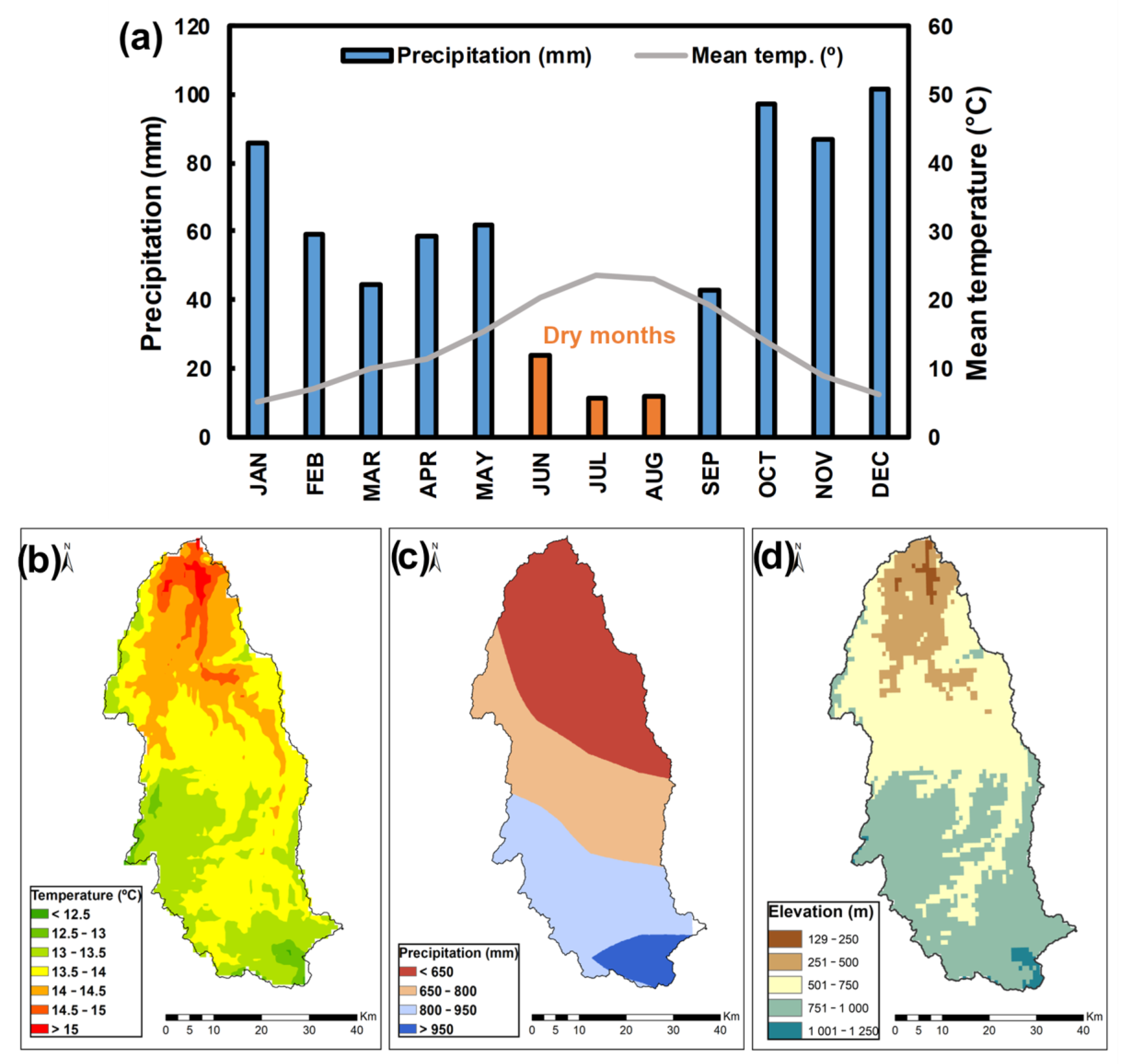
Regarding the climatic characteristics, the Côa basin presents Mediterranean-type conditions, with warm dry summers and moderately cold and rainy winters (Figure 2a). The precipitation during summer can be very limiting, with approximately 10 mm in the summer months (Figure 2a). From the Ombrothermic diagram (Figure 2a), it is clear that June, July, and August can be considered dry months, whereas September is almost in this category. One particularity is that March is only marginally wet. The annual mean temperature throughout the region ranges from 12.5 to 15 °C, with a latitudinal gradient, where the southern low-elevation areas are considerably warmer than the northern high-elevation areas (Figure 2b,d). Concerning the annual accumulated precipitation, the values range from <650 mm in the north to >950 mm in the south. The regional patterns also depict a south–north latitudinal gradient, showing a northward decrease in precipitation, again correlated with elevation (Figure 2c).

2.3. Hydrological Model Characterization
“Better Assessment Science Integrating Point and Nonpoint Sources” (BASINS) is a multipurpose environmental analysis system developed by the U.S. Environmental Protection Agency’s (EPA’s) Office of Water [27]. It serves as an interface where users can simulate water quantity and quality for a set of nodes and/or zones, denominated as Hydrological Response Units [27]. This can be carried out through the Hydrological Simulation Program—FORTRAN (HSPF), a deterministic simulation model [28]. This extension simulates the hydrological processes on pervious and impervious land surfaces and in streams and well-mixed impoundments [29]. BASINS also includes the WDMUtil utility, which allows for creating Watershed Data Management (WDM) data files, based on daily precipitation and daily minimum and maximum temperatures. From these data, WDMUtil extrapolates hourly precipitation, hourly mean temperature, as well as actual and potential evapotranspiration. A flowchart representing this methodology is available in Supplementary Figure S1.
Figure 2. Historical climate data (1985–2014) for the Côa River basin. (a) Ombrothermic diagram, (b) annual mean 2-m air temperature (°C), and (c) annual accumulated precipitation (mm) retrieved from the IBERIA01 dataset [30]. The orange-colored bars in the Ombrothermic diagram indicate the dry months. (d) Elevation (m) in the Côa River basin.
Water 15 02739 g002

2.4. Recent-Past and Future Climate Data

Hydrological models require daily precipitation and minimum and maximum temperatures as input. These data were retrieved from the EURO-CORDEX database, available at the C3S platform [31], and were obtained from three global–regional climate model (GCM-RCM) pair simulations at a 0.125° spatial resolution [32] (Table 2). Not limiting this study to a single climatic model enables taking into account model uncertainties [33]. These sources of uncertainty derive from the fact that climate models have limitations that affect the accuracy of their projections. Uncertainties arise from physical processes, feedback mechanisms, future emissions of greenhouse gases and aerosols, and variability in model initialization. Therefore, using an ensemble modeling approach is usually preferable to a single-model approach.
To carry out hydrological modeling, three distinct periods were selected: historical (1985–2014), future mid-term (2040–2069), and long-term (2070–2099). For the future, simulations under RCP8.5 (Representative Concentration Pathways) were considered. This is considered a severe (fossil-intensive) future scenario, due to the projected sustained increase in greenhouse gas concentrations until the end of the century. Other more moderate future pathways, such as RCP4.5, only start to significantly diverge from RCP8.5 after the mid-21st century [34] and therefore were not considered in the present study. According to the EURO-CORDEX, the RCM’s initializations are provided by the corresponding GCM and are, therefore, unsynchronized model outputs. Model simulation biases are present in both present and future model data and do not affect the climate change delta signal (e.g., future minus present). In the present study, the influence of the aforementioned bias is not relevant, as a normalization procedure was applied using the historical period as a baseline.

2.5. Côa Watershed Delineation and Segmentation

Prior to the hydrological model runs, a delineation and segmentation of the Côa basin were performed. This is a necessary pre-processing step for the semi-distributed modeling approach to define the Hydrological Response Units (HRU). A Digital Elevation Model (DEM), with a spatial resolution of 25 m, was retrieved from the Copernicus data repository and created by the European Environment Agency (EEA), more specifically the EU-DEM v1.1 dataset, and then the geographical sheet E20N20. Additionally, data for land use in the Côa basin were also retrieved [2]. Each land classification was assigned to a class that will serve as input for the HSPF and a percentage of impervious land is attributed (Supplementary Tables S1 and S2). The watershed was subsequently split into sub-basins, derived from the DEM delineation and segmentation with the BASINS software v4.5 [24]. The threshold area for the delimitation was 11,026 ha and resulted in a grid cell number threshold equal to 387,599, which represents 284 m2/cell, and 13 outlets that define linkages between streams. This procedure resulted in 13 HRUs, also considering the attribution of various climatic values and land cover usage for each of the HRUs. Although additional sub-basins could be defined, this would considerably increase the computational effort and may reveal some inconsistencies in the streamflow simulations [25].
Due to the climate data resolution (~12.5 km), some of these HRUs are contained in more than one climatic grid cell; however, only one value is allowed as input for the HSPF for each HRU. To overcome this issue, the climatic data for some sub-basins are the average of all the grid cells that overlap the HRU at the daily timescale. Hence, for the 13 HRUs, there were a total of 24 climatic data points that were averaged into 13. Regarding the land cover data, a clipping inside the Côa River basin was performed, which also served as an input for the HSPF model (conversion of land use type into pervious and impervious land segments—Supplementary Tables S1 and S2). The HSPF model was then run at a daily timestep, using each of the three GCM–RCM simulated datasets as inputs, separately. The streamflow outputs for the different climatic data and periods were then obtained, assessing the streamflow for the whole basin (Côa River’s mouth). Finally, all streamflow outputs were then normalized using the historical values as a baseline, resulting in a percental dataset.

2.6. Hydrometric Model Evaluation

The hydrological model outputs were assessed before analyzing the streamflow climate change signal, by conducting a comparison of the simulated data with the observational monthly mean streamflow from “Cidadelhe” for 1985–2010. Although this comparison is useful, it stresses the lack of observational data for the Côa basin, since the simulated streamflow data collected refer to the Côa River’s mouth, whereas the observational station is approximately 20 km upstream. Therefore, to provide this comparison, a normalization (min–max scaling) procedure was first applied to the observational and modeled monthly time series. Thus, to evaluate the performance of the hydrological model, normalized monthly simulated streamflow by the three climatic models over the recent past was compared to normalized monthly observed flow. This comparison may clarify the streamflow response of the HSPF module to each climate model used. Subsequently, future projections for streamflow were analyzed.

2.7. Future Uncertainties Irrigation Scenarios

To perform a suitable discussion of future water use for irrigation in the Côa basin, an attempt was made to analyze current irrigation water use and establish future irrigation scenarios for subsequent comparison with future projections of streamflow in the Côa River. As previously mentioned, in the Côa basin, agricultural land accounts for approximately 82 × 103 ha. Considering the latest documented irrigated fraction of agricultural land value of 15.9% (national assessment [35]), it is estimated that in this region about 13 × 103 ha of agricultural land is irrigated, resulting in a total of approximately 46 hm3·yr−1 of water use (Table 3). These values take up a relatively small fraction (~7%) of the total water volume of the Côa basin, which is 620 hm3·yr−1 in a normal year [1]. For the future, taking into account climate change, we aim to establish potential scenarios, considering an increase in irrigation demands. These demands may result from additional cultivated land and/or additional water demands due to severe droughts and warmer climates. According to several studies, projections suggest that irrigation demand in Mediterranean climates may increase by 10% to 20% or more in the upcoming decades [36]. Therefore, we establish five scenarios with a decadal increase of 10%, 20%, 30%, 40%, and 50%, in line with other studies but also considering a further possible increase due to irrigation efficiency losses.

3. Results

3.1. Hydrological Model Evaluation: Historical Period

From 1985 to 2010, the HSPF (normalized) monthly mean simulated flows consistently matched the observed flows at the “Cidadelhe” hydrometric station, indicating a strong agreement (Figure 3). From the results for the three climatic models, CCLM shows the lowest determination coefficient, i.e., R-squared metric (R2 = 0.79), MPISMHI shows an R2 = 0.81, and IDMI an R2 = 0.84. The analysis of the residuals (distance to dotted lines) shows a symmetrical distribution for positive and negative streamflow anomalies and the three climatic models. Nonetheless, a slight overestimation of the simulated values is found for the mid-range streamflow, which is typically associated with the spring months. The driest season/lowest values (summer) show coherence across different periods and models, which indicates the lowest groundwater reservoir levels [37]. Despite this slight overestimation, the HSPF model effectively simulated the mean hydrology of the Côa basin. The regression lines obtained from the simulated data skew slightly from the 1:1 slope between observed and simulated data. From this, a symmetry of the data with respect to the regression line was expected and is particularly clear in the drier months. The intersection between the computed regression line and the 1:1 slope is slightly different among the three climatic models. This suggests relatively slight differences among the three climatic models in terms of precipitation.

3.2. Future Streamflow in the Côa River

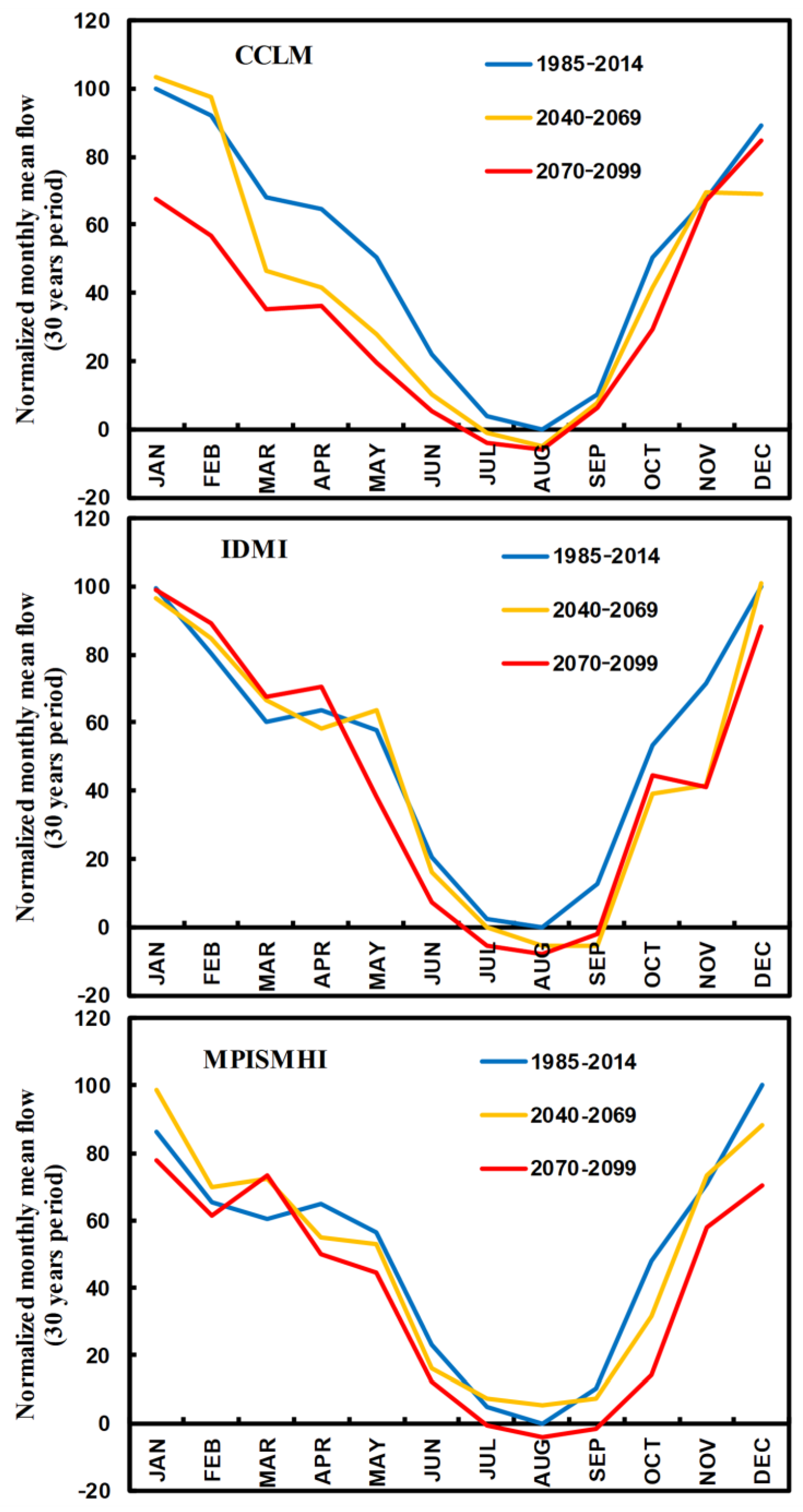
Figure 4 presents the monthly mean streamflow (normalized) for the recent-past and future periods (1985–2014, 2040–2069, and 2070–2099). Concerning the monthly mean streamflow in both the recent-past and future periods, it should be noted that the normalization procedure was herein undertaken using the recent-past streamflow as a baseline (in some cases resulting in values higher than 100% or lower than 0%). The average (±standard deviation is shown in Supplementary Figure S2) for each period was analyzed, effectively depicting the future changes for each month in terms of streamflow ranges. Overall, for future periods, a decrease in streamflow is expected, whereas some exceptions are found particularly in the first months of the year, depending on the model and period. This is the result of a higher precipitation amount projected for these months under future scenarios. Conversely, for the remaining months, future streamflow is expected to decrease (with the exception of November for CCLM and the first period in MPISMHI). For the 2070–2099 period, the reduction in streamflow is stronger and much more generalized throughout the year, with IDMI being the exception in the first three months, and MPISMHI in March. These results suggest an intensification of drought conditions in the region. The simulations tend to follow the same patterns in both the upper (avg + std) and lower (avg-std) bounds (Figure S2).
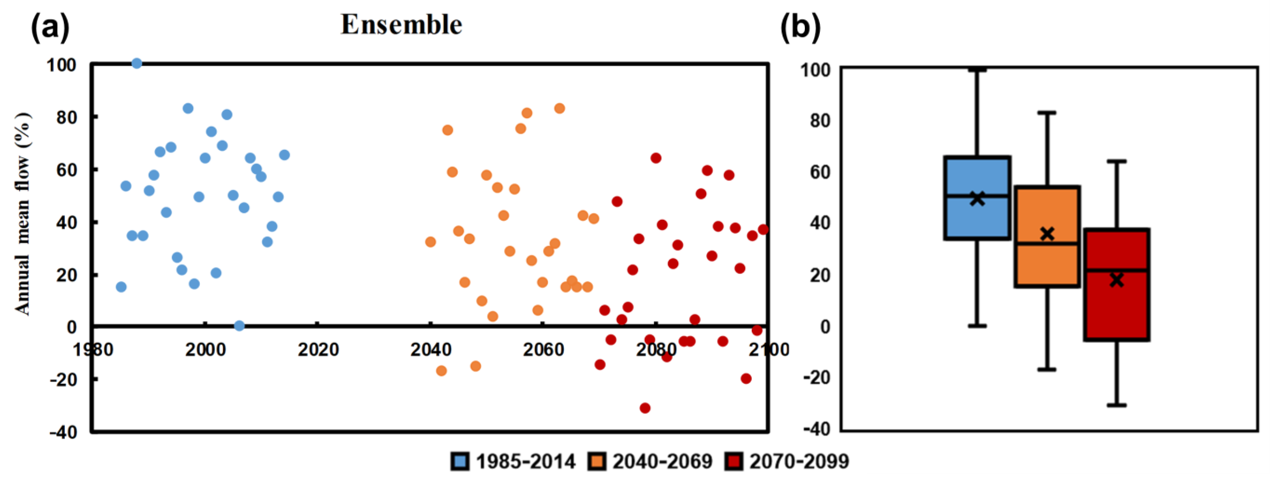
Figure 5 shows the annual mean streamflow for the recent-past and future periods (normalized using the recent past as a baseline). The results show a decrease in the annual mean flow of −30% until 2099, −20% in the medium-term period, and an additional decrease of −10% for the long-term period. Regarding the interannual variability (interquartile ranges, i.e., 75-th quantile, Q75, minus 25-th quartile, Q25), these are also expected to increase. This reflects an increase in uncertainty in the streamflow of the Côa River, with an emphasis on the latter period (2070–2099). Objectively, for over 10 years in the long-term period, the streamflow is lower than the lowest in the recent past period. It is noticeable that not only does the interval between Q25 and Q75 increase for future projections but also the mean and median values differ from each other in a non-similar manner. The mean is higher than the median for the mid-term projection, whereas the opposite occurs for the long-term period. This can be associated with the different skewness of the daily streamflow series, which may have an impact on annual mean terms.

3.3. Future Irrigation Scenarios

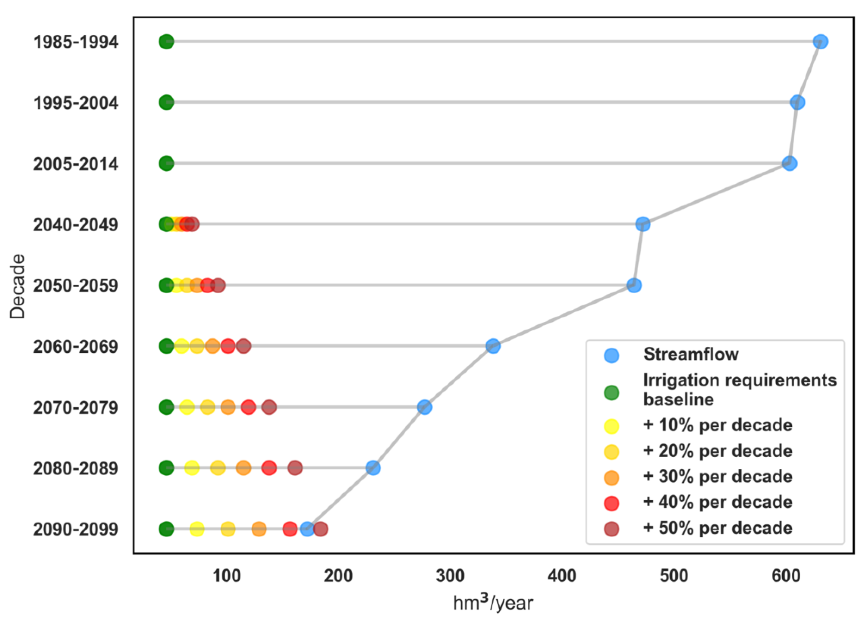
Figure 6 illustrates the decadal change in mean streamflow in the Côa River, along with the values of water demands for irrigation, considering the irrigation scenarios established in this study, i.e., an increase of 10% to 50% per decade. The baseline scenario, representing current water demands for irrigation, indicates a value of 46 hm3·yr−1. However, when considering the projected increase in irrigation demands, the results point to a potential rise in water demands from the baseline to 184 hm3·yr−1 with a 50% increase per decade. These scenarios highlight a substantial growth in irrigation needs over time, potentially driven by factors such as population growth, agricultural expansion, and changing agricultural practices. The results portray a projected decrease in streamflow, estimating a value of approximately 180 hm3·yr−1 by 2099. This decrease in streamflow indicates a reduction in the availability of water resources in the Côa River. The combined effects of the potential increase in irrigation demands and the decrease in streamflow present significant challenges for sustainable water resources management in the target region.

4. Discussion

The increasing gap between water demands and available water resources raises concerns about the feasibility of meeting irrigation needs while ensuring the long-term sustainability of the water supply. In the present study, the main objective was to evaluate the potential impact of climate change on the Côa River basin by simulating recent-past and future streamflow [36]. This assessment also focused on understanding the potential consequences of crop irrigation. The simulation was carried out using the HSPF hydrological model, and the analysis was based on climatic data from three GCM-RCM model chains under the RCP8.5 scenario, until 2099. In an attempt to fill the knowledge gap, the current study sought to provide a quantifiable analysis of the annual flow of available water, as well as the impact of increasing amounts that might be withdrawn for agricultural purposes [38,39].
The application of the HSPF model to the Côa basin presented certain challenges. Firstly, the basin’s high spatial variability and heterogeneity brought about several difficulties. Additionally, the lack of data (semi-gauged basin) to validate the model outcomes further complicated the analysis. Despite these challenges, it is crucial to perform studies on semi-gauged basins with heterogeneous and discontinuous data, as they contribute to enhancing our understanding of different catchment types [40]. To address the influence of the observed data series when compared with simulated data, a normalization procedure was applied to the model outputs. This procedure helped mitigate the impact of varying data availability. Furthermore, the analysis focused not only on annual and monthly relative changes but also emphasized that the magnitude values of the simulation should not be overemphasized [41].
The results indicated that the HSPF model successfully captured the flow patterns and dynamics of the Côa basin during the historical period. Moreover, the model demonstrated an unbiased representation of the flow variability. Although some studies (regarding urban areas) have reported the HSPF overestimating flow by up to 50% in certain areas and months [42], and others have observed underestimation [43], herein, the high correlation (monthly mean flow R2 > 0.79) suggests that the model will perform reliably under future projections. Notably, the use of a climate model ensemble to provide input data to the hydrological model is of great importance. Climate change projections generated by global–regional climate model chains attempt to simulate vast spatial–temporal possibilities, even though it has raised some questions in terms of precipitation on long-term projections [44]. Hence, a three-member model ensemble was chosen to evaluate the annual mean flow for the three periods of study [45,46]. The results revealed that the IDMI climatic model replicated the observed flows most accurately, the CCLM model showed a relatively lower correlation, and the MPISMHI model performed at an intermediate level. Incorporating these three climatic models in the streamflow simulation allowed us to account for the uncertainties associated with the model experiments.
Looking into the future, HSPF outputs for each of the three climatic models projected a significant decrease in the Côa River streamflow, both in terms of monthly mean and annual mean values. Under the assumption that the uncertainties added by the hydrological model can be partially offset when normalizing the simulated flows, taking into account observational flows [47], we were able to evaluate the response of the catchment. Therefore, it is not surprising to observe negative percentages during future periods with respect to the historical period. According to this future scenario, it is expected that the annual streamflow will steadily decrease until the end of this century. It should be noted that, whereas other future scenarios were not assessed, such as the more moderate RCP4.5, this scenario shares nearly the same pathway until the mid-century. Therefore, the hydrometric projections for a more moderate future scenario should largely overlap with the results for RCP8.5.
The expected decrease in future river flow should derive from changes in precipitation (temporal and spatial) from one period of analysis to another [48]. The boxplot in Figure 5 indicates an increase in inter-annual variability because the range for future periods is wider than that of the recent past. It is also remarkable that the range between Q25 and Q75 of streamflow is greater for the long-term future period than the mid-term projection. Artificial reservoirs were not taken into account in the HSPF due to the lack of such structures in the Côa basin. Additionally, the reduction in rainfall may lead to higher-than-anticipated reductions in runoff after the long dry Mediterranean summers. The flow regime and its implications on ecological features are slightly sensitive to the percentage of impervious land [49,50]. Although urban land and wetland areas, both with high impervious percentages as shown in Table S2, are not of considerable weight, it is necessary to clarify that the high impervious coefficient related to forest land has a different impact on the flow regime [51,52]. The HSPF simulation may interpret the Côa River basin as a natural catchment due to the ratio between forest and urban land [53]. Furthermore, future modifications in these land cover type ratios may considerably alter the outcomes of the present study.
Although the ecological flow of the Côa River (i.e., quantity, timing, and quality of water required in a river) can be inferred from the mean annual flow rates, it was not evaluated in this study, as observational daily data were extremely scarce to attain a holistic view. Nonetheless, some assessments can be made, particularly since the change in the base flow towards the ecological flow may have direct effects on the use of water for agriculture [54,55], on the quality of water after discharges from WWTPs (Waste Water Treatment Plant), as well as on the wealth of riparian fauna and flora [56]. A future decrease in annual flows may increase the water demands for all sectors of activity, particularly in the dryer summer months [57].
The future irrigation scenarios considered in this study, targeting the potential increase in irrigation demands by up to 50% in the Côa region, combined with a decrease in water availability in the catchment of up to 30%, present significant challenges for sustainable water resource management [58]. Higher irrigation demands surely imply a significant expansion of agricultural activities, which may not be the case. Nevertheless, an expansion may be driven by factors such as population growth and the need to enhance food security [59]. The Côa region is home to highly sought-after crops, particularly known for their quality attributes, such as grapevines and wines, olives and olive oil, and almonds. It is expected that the high demand for these exceptional-quality food products may increase in the future [8,9,60].
Meeting increased irrigation demands will require the development of additional irrigation infrastructure and the adoption of efficient water management practices to ensure sustainable agricultural production [61]. However, the potential increase in irrigation demands must be viewed in conjunction with the projected decrease in water availability in the catchment by up to 30%, following our simulations. The combination of higher irrigation demands and reduced water availability yields significant challenges for water resource management in the Côa region. The implications of this scenario are multifaceted and require careful consideration. Firstly, agricultural productivity may be affected by limited water availability, leading to reduced crop yields, and potentially affecting the overall agricultural output. Farmers will need to adopt water-efficient irrigation techniques, such as drip irrigation and precision farming, to optimize water use and minimize losses [12]. Secondly, the environmental implication of increased irrigation demands and decreased water availability do need to be fully assessed. Lower river flow and reduced groundwater recharge can result in ecological imbalances, affecting aquatic ecosystems and biodiversity [62]. Mitigation measures, such as establishing water allocation mechanisms, implementing water conservation measures, and protecting sensitive ecological areas, should be considered to maintain the ecological integrity of the Côa region.
The socioeconomic implications of this scenario may not be overlooked [63]. The agricultural sector in the Côa region plays a crucial role in the local economy, providing employment and income for many communities. A decline in agricultural productivity due to water scarcity could have far-reaching economic consequences, including reduced livelihood opportunities, migration, and increased dependence on external food sources. As such, a comprehensive and integrated approach that addresses agricultural productivity, environmental concerns, and socioeconomic implications should take place. By adopting water-efficient practices, investing in infrastructure, and promoting stakeholder collaboration, the Côa region can strive towards a resilient and sustainable future.
These strategies should focus on a combination of demand-side and supply-side measures. On the demand side, promoting water-efficient agricultural practices, encouraging crop diversification, and implementing water pricing mechanisms can help optimize water use and reduce irrigation demands [64]. Examples of these agronomic practices are the application of smart/deficit irrigation, or other water-saving techniques, such as mulching [65]. A more distributed and widespread hydrological monitoring system throughout the Côa basin is necessary to assess with higher accuracy the response of streamflow to future climatic projections [66]. On the supply side, investing in water storage infrastructures, such as reservoirs and dams, can help capture and store water during periods of high streamflow, ensuring a more reliable water supply during dry periods. These structures may prove vital under future climates [43]. Water allocation from nearby catchments may also be considered [67]. Furthermore, expanding the water distribution network and exploring alternative water sources, such as treated wastewater and rainwater harvesting, can also contribute to augmenting water availability.
Integrated water resource management requires close collaboration among stakeholders, including farmers, governmental agencies, water users, and researchers. Participatory approaches and stakeholder engagement can foster the development and implementation of effective water management strategies, considering the diverse interests and concerns of various stakeholders. Regular monitoring and assessment of water resources, climate patterns, and agricultural practices are vital for adaptive management and decision-making. This enables policymakers and water managers to track alterations, identify trends, and adjust management strategies accordingly.

5. Conclusions

In summary, the research conducted on the Côa River basin provides valuable insights into the implications of climate change on river basin water for agricultural irrigation. Employing the HSPF hydrological model and climate data from multiple sources, this study reveals a projected decrease in future streamflow, both in terms of monthly and annual mean values. This anticipated reduction in water availability, which coupled with potential increases in irrigation demands presents substantial challenges for ensuring the long-term sustainability of water resources in the Côa region. Consequently, it is imperative to adopt water-efficient agricultural practices, invest in appropriate infrastructure, implement effective water-pricing mechanisms, and foster stakeholder collaboration to facilitate adaptive water management strategies. Moreover, the environmental and socioeconomic repercussions of these changes require careful consideration, including their potential impact on crop yields, and the impact on local economies.

Supplementary Materials

The following supporting information can be downloaded at: https://www.mdpi.com/article/10.3390/w15152739/s1, Table S1: Land cover types in the Côa River basin, retrieved from the Portuguese Land Cover (COS) dataset [2], and the corresponding values in the HSPF model. Table S2: Percentages of impervious land according to each land use type. Figure S1: Flowchart representing the hydrological modelling. Figure S2: Monthly mean streamflow (normalized) for the recent-past and future periods (1985–2014, 2040–2069 and 2070–2099). The lines represent the average (Avg) ± standard deviation (Std) for each period.

Author Contributions

Conceptualization, H.F., J.A.S., D.R. and A.F.; methodology, D.R., A.F. and H.F.; software, D.R., A.F. and H.F.; validation, D.R., A.F. and H.F.; formal analysis, D.R. and H.F.; investigation, D.R. and H.F.; resources, D.R., A.F. and H.F.; data curation, D.R., A.F. and H.F.; writing—original draft preparation, D.R. and H.F.; writing—review and editing, D.R., A.F., O.S., T.R.F., N.G., J.A.S. and H.F.; visualization, D.R., A.F., O.S., T.R.F., N.G., J.A.S. and H.F.; supervision, H.F.; project administration, H.F.; funding acquisition, H.F. All authors have read and agreed to the published version of the manuscript.

Funding

This work was financed by the CoaClimateRisk “O impacto das alterações climáticas e medidas de adaptação para as principais culturas agrícolas na região do Vale do Côa” project (COA/CAC/0030/2019), financed by National Funds by the Portuguese Foundation for Science and Technology (FCT).

Data Availability Statement

All datasets used are publicly available.

Acknowledgments

This work was financed by the CoaClimateRisk “O impacto das alterações climáticas e medidas de adaptação para as principais culturas agrícolas na região do Vale do Côa” project (COA/CAC/0030/2019) financed by National Funds by the Portuguese Foundation for Science and Technology (FCT). We also thank projects UIDB/04033/2020, LA/P/0126/2020 and 2022.04553.PTDC. N.G. thanks the financial support provided by national funds through FCT—Portuguese Foundation for Science and Technology (UI/BD/150727/2020), under the doctoral program “Agricultural Production Chains—from fork to farm” (PD/00122/2012) and from the European Social Funds and the Regional Operational Program Norte 2020. H.F. thanks the FCT for 2022.02317.CEECIND.

Conflicts of Interest

The authors declare no conflict of interest.

References

  1. APA. Plano de Gestão Hidrográfica do Douro 2016–2021—Parte 2—Caracterização e Diagnostico; Agência Portuguesa do Ambiente: Amadora, Portugal, 2019; p. 52. [Google Scholar]
  2. SNIG Carta de Uso e Ocupação do Solo. Available online: https://snig.dgterritorio.gov.pt/rndg/srv/por/catalog.search#/home (accessed on 27 January 2023).
  3. Fraga, H.; Santos, J.A. Assessment of Climate Change Impacts on Chilling and Forcing for the Main Fresh Fruit Regions in Portugal. Front. Plant Sci. 2021, 12, 689121. [Google Scholar] [CrossRef]
  4. Zhang, S.; Li, S.; Shu, L.; Xiao, T.; Shui, T. Landscape Configuration Effects on Outdoor Thermal Comfort across Campus—A Case Study. Atmosphere 2023, 14, 270. [Google Scholar] [CrossRef]
  5. Rodrigues, C.M.; Guimarães, R.C.; Moreira, M. Apontamentos Para as Aulas de Hidrologia; Departamento de Engenharia Rural: Evora, Portugal, 2011. [Google Scholar]
  6. CPPE—Companhia Portuguesa de Produção de Electricidade, S.A. Avaliação Comparada dos Aproveitamentos do Baixo Sabor e do Alto Côa; CPPE—Companhia Portuguesa de Produção de Electricidade, S.A: Setúbal, Portugal, 2002. [Google Scholar]
  7. Bednar-Friedl, B.; Biesbroek, R.; Schmidt, D.N.; Alexander, P.; Børsheim, K.Y.; Carnicer, J.; Georgopoulou, E.; Haasnoot, M.; Cozannet, G.L.; Lionello, P.; et al. Europe. In Climate Change 2022: Impacts, Adaptation and Vulnerability. Contribution of Working Group II to the Sixth Assessment Report of the Intergovernmental Panel on Climate Change; Cambridge University Press: Cambridge, UK; New York, NY, USA, 2022; pp. 1817–1927. ISBN 978-1-00-932584-4. [Google Scholar]
  8. Fraga, H.; Guimarães, N.; Freitas, T.R.; Malheiro, A.C.; Santos, J.A. Future Scenarios for Olive Tree and Grapevine Potential Yields in the World Heritage Côa Region, Portugal. Agronomy 2022, 12, 350. [Google Scholar] [CrossRef]
  9. Freitas, T.R.; Santos, J.A.; Silva, A.P.; Martins, J.; Fraga, H. Climate Change Projections for Bioclimatic Distribution of Castanea Sativa in Portugal. Agronomy 2022, 12, 1137. [Google Scholar] [CrossRef]
  10. Yang, C.; Menz, C.; De Abreu Jaffe, M.S.; Costafreda-Aumedes, S.; Moriondo, M.; Leolini, L.; Torres-Matallana, A.; Molitor, D.; Junk, J.; Fraga, H.; et al. Projections of Climate Change Impacts on Flowering-Veraison Water Deficits for Riesling and Müller-Thurgau in Germany. Remote Sens. 2022, 14, 1519. [Google Scholar] [CrossRef]
  11. Lobell, D.; Burke, M.; Tebaldi, C.; Mastrandrea, M.; Falcon, W.; Naylor, R. Prioritizing Climate Change Adaptation Needs for Food Security in 2030. Science 2008, 319, 607–610. [Google Scholar] [CrossRef]
  12. Grafton, R.Q.; Williams, J.; Perry, C.J.; Molle, F.; Ringler, C.; Steduto, P.; Udall, B.; Wheeler, S.A.; Wang, Y.; Garrick, D.; et al. The Paradox of Irrigation Efficiency. Science 2018, 361, 748–750. [Google Scholar] [CrossRef] [Green Version]
  13. Piao, S.; Ciais, P.; Huang, Y.; Shen, Z.; Peng, S.; Li, J.; Zhou, L.; Liu, H.; Ma, Y.; Ding, Y.; et al. The Impacts of Climate Change on Water Resources and Agriculture in China. Nature 2010, 467, 43–51. [Google Scholar] [CrossRef]
  14. Iglesias, A.; Garrote, L.; Flores, F.; Moneo, M. Challenges to Manage the Risk of Water Scarcity and Climate Change in the Mediterranean. Water Resour. Manag. 2007, 21, 775–788. [Google Scholar] [CrossRef]
  15. Pordata. Superfície Agrícola Utilizada: Irrigável e Regada (%); Pordata: Lisbon, Portugal, 2019. [Google Scholar]
  16. Gosling, S.N.; Arnell, N.W. A Global Assessment of the Impact of Climate Change on Water Scarcity. Clim. Chang. 2016, 134, 371–385. [Google Scholar] [CrossRef] [Green Version]
  17. Wisser, D.; Frolking, S.; Douglas, E.M.; Fekete, B.M.; Vörösmarty, C.J.; Schumann, A.H. Global Irrigation Water Demand: Variability and Uncertainties Arising from Agricultural and Climate Data Sets. Geophys. Res. Lett. 2008, 35, L24408. [Google Scholar] [CrossRef] [Green Version]
  18. Gorguner, M.; Kavvas, M.L. Modeling Impacts of Future Climate Change on Reservoir Storages and Irrigation Water Demands in a Mediterranean Basin. Sci. Total Environ. 2020, 748, 141246. [Google Scholar] [CrossRef]
  19. Gonçalves, C.; Honrado, J.P.; Cerejeira, J.; Sousa, R.; Fernandes, P.M.; Vaz, A.S.; Alves, M.; Araújo, M.; Carvalho-Santos, C.; Fonseca, A.; et al. On the Development of a Regional Climate Change Adaptation Plan: Integrating Model-Assisted Projections and Stakeholders’ Perceptions. Sci. Total Environ. 2022, 805, 150320. [Google Scholar] [CrossRef]
  20. Best, A.E.; Zhang, L.; McMahon, T.; Western, A.; Vertessy, R. A Critical Review of Paired Catchment Studies with Reference to Seasonal Flows and Climatic Variability; Murray Darling Basin Commission: Canberra, Australia, 2003.
  21. Yang, X.; Ren, L.; Singh, V.P.; Liu, X.; Yuan, F.; Jiang, S.; Yong, B. Impacts of Land Use and Land Cover Changes on Evapotranspiration and Runoff at Shalamulun River Watershed, China. Hydrol. Res. 2012, 43, 23–37. [Google Scholar] [CrossRef]
  22. Sondermann, M.N.; de Oliveira, R.P. Climate Adaptation Needs to Reduce Water Scarcity Vulnerability in the Tagus River Basin. Water 2022, 14, 2527. [Google Scholar] [CrossRef]
  23. Sánchez-Gómez, A.; Martínez-Pérez, S.; Leduc, S.; Sastre-Merlín, A.; Molina-Navarro, E. Streamflow Components and Climate Change: Lessons Learnt and Energy Implications after Hydrological Modeling Experiences in Catchments with a Mediterranean Climate. Energy Rep. 2023, 9, 277–291. [Google Scholar] [CrossRef]
  24. Jajarmizad, M.; Harun, S.; Salarpour, M. A Review on Theoretical Consideration and Types of Models in Hydrology. J. Environ. Sci. Technol. 2012, 5, 249–261. [Google Scholar] [CrossRef] [Green Version]
  25. Jorge, M.; Ramos, C. Análise Morfométrica do Estádio Evolutivo de Sub-bacias da Bacia Hidrográfica do Rio Côa. In Atas do V Congresso Nacional de Geomorfologia; Associação Portuguesa de Geomorfólogos: Porto, Portugal, 2010; pp. 475–480. ISBN 978-989-96462-2-3. [Google Scholar]
  26. van Emmerik, T.; Mulder, G.; Eilander, D.; Piet, M.; Savenije, H. Predicting the Ungauged Basin: Model Validation and Realism Assessment. Front. Earth Sci. 2015, 3, 62. [Google Scholar] [CrossRef] [Green Version]
  27. Kinerson, R.S.; Kittle, J.L.; Duda, P.B. BASINS: Better Assessment Science Integrating Point and Nonpoint Sources. In Decision Support Systems for Risk-Based Management of Contaminated Sites; Marcomini, A., Suter, G.W., II, Critto, A., Eds.; Springer: Boston, MA, USA, 2009; pp. 1–24. ISBN 978-0-387-09721-3. [Google Scholar]
  28. Poole, D.; Raftery, A.E. Inference for Deterministic Simulation Models: The Bayesian Melding Approach. J. Am. Stat. Assoc. 2000, 95, 1244–1255. [Google Scholar] [CrossRef]
  29. Bicknell, B.R.; Imhoff, J.C.; Kittle, J.L., Jr.; Donigian, A.S., Jr.; Johanson, R.C. Hydrological Simulation Program—FORTRAN User’s Manual for Version 11. In Environmental Protection Agency Report No. EPA/600/R-97/080; US Environmental Protection Agency: Athens, GA, USA, 1997. [Google Scholar]
  30. Gutiérrez, J.M.; Herrera, S.; Cardoso, R.M.; Soares, P.M.M.; Espírito-Santo, F.; Viterbo, P. Iberia01: Daily Gridded (0.1° Resolution) Dataset of Precipitation and Temperatures over the Iberian Peninsula. Earth Syst. Sci. Data 2019, 11, 1947–1956. [Google Scholar]
  31. Copernicus Climate Change Service. CORDEX Regional Climate Model Data on Single Levels; Copernicus Climate Change Service: Brussels, Belgium, 2019. [Google Scholar]
  32. Pitman, A.J.; Arneth, A.; Ganzeveld, L. Regionalizing Global Climate Models: Regionalizing Global Climate Models. Int. J. Climatol. 2012, 32, 321–337. [Google Scholar] [CrossRef]
  33. Allen, M.R.; Stott, P.A.; Mitchell, J.F.B.; Schnur, R.; Delworth, T.L. Quantifying the Uncertainty in Forecasts of Anthropogenic Climate Change. Nature 2000, 407, 617–620. [Google Scholar] [CrossRef]
  34. van Vuuren, D.P.; Edmonds, J.; Kainuma, M.; Riahi, K.; Thomson, A.; Hibbard, K.; Hurtt, G.C.; Kram, T.; Krey, V.; Lamarque, J.-F.; et al. The Representative Concentration Pathways: An Overview. Climatic Chang. 2011, 109, 5. [Google Scholar] [CrossRef]
  35. INE. O Uso da Água na Agricultura: 2011; Instituto Nacional de Estatística: Madrid, Portugal, 2011; p. 95.
  36. Esteve, P.; Varela-Ortega, C.; Blanco-Gutiérrez, I.; Downing, T.E. A Hydro-Economic Model for the Assessment of Climate Change Impacts and Adaptation in Irrigated Agriculture. Ecol. Econ. 2015, 120, 49–58. [Google Scholar] [CrossRef] [Green Version]
  37. Hanasaki, N.; Kanae, S.; Oki, T. A Reservoir Operation Scheme for Global River Routing Models. J. Hydrol. 2006, 327, 22–41. [Google Scholar] [CrossRef]
  38. Garrote, L.; Iglesias, A.; Granados, A.; Mediero, L.; Martin-Carrasco, F. Quantitative Assessment of Climate Change Vulnerability of Irrigation Demands in Mediterranean Europe. Water Resour. Manag. 2015, 29, 325–338. [Google Scholar] [CrossRef]
  39. Thomas, A. Agricultural Irrigation Demand under Present and Future Climate Scenarios in China. Glob. Planet. Chang. 2008, 60, 306–326. [Google Scholar] [CrossRef]
  40. Cui, X.; Sun, W.; Teng, J.; Song, H.; Yao, X. Effect of Length of the Observed Dataset on the Calibration of a Distributed Hydrological Model. Proc. IAHS 2015, 368, 305–311. [Google Scholar] [CrossRef] [Green Version]
  41. Im, S.; Brannan, K.M.; Cho, J.H.; Mostaghimi, S. A Comparison of SWAT and HSPF Models for Simulating Hydrologic and Water Quality Responses from an Urbanizing Watershed. In Proceedings of the 2003 ASAE Annual International Meeting Sponsored by ASAE Riviera Hotel and Convention Center, Las Vegas, NV, USA, 27–30 July 2003. [Google Scholar]
  42. Singh, J.; Knapp, H.V.; Arnold, J.G.; Demissie, M. Hydrological Modeling of the Iroquois River Watershed Using HSPF and SWAT. J. Am. Water Resour. Assoc. 2005, 41, 343–360. [Google Scholar] [CrossRef]
  43. Nayeb Yazdi, M.; Ketabchy, M.; Sample, D.J.; Scott, D.; Liao, H. An Evaluation of HSPF and SWMM for Simulating Streamflow Regimes in an Urban Watershed. Environ. Model. Softw. 2019, 118, 211–225. [Google Scholar] [CrossRef]
  44. Siam, M.S.; Eltahir, E.A.B. Climate Change Enhances Interannual Variability of the Nile River Flow. Nat. Clim. Chang. 2017, 7, 350–354. [Google Scholar] [CrossRef]
  45. Senatore, A.; Fuoco, D.; Maiolo, M.; Mendicino, G.; Smiatek, G.; Kunstmann, H. Evaluating the Uncertainty of Climate Model Structure and Bias Correction on the Hydrological Impact of Projected Climate Change in a Mediterranean Catchment. J. Hydrol. Reg. Stud. 2022, 42, 101120. [Google Scholar] [CrossRef]
  46. Wiel, K.; Wanders, N.; Selten, F.M.; Bierkens, M.F.P. Added Value of Large Ensemble Simulations for Assessing Extreme River Discharge in a 2 °C Warmer World. Geophys. Res. Lett. 2019, 46, 2093–2102. [Google Scholar] [CrossRef] [Green Version]
  47. Refsgaard, J.C.; van der Sluijs, J.P.; Højberg, A.L.; Vanrolleghem, P.A. Uncertainty in the Environmental Modelling Process—A Framework and Guidance. Environ. Model. Softw. 2007, 22, 1543–1556. [Google Scholar] [CrossRef] [Green Version]
  48. Mahlman, J.D. Uncertainties in Projections of Human-Caused Climate Warming. Science 1997, 278, 1416–1417. [Google Scholar] [CrossRef] [Green Version]
  49. Arnold, C.L.; Gibbons, C.J. Impervious Surface Coverage: The Emergence of a Key Environmental Indicator. J. Am. Plan. Assoc. 1996, 62, 243–258. [Google Scholar] [CrossRef]
  50. Poff, N.L.; Allan, J.D.; Bain, M.B.; Karr, J.R.; Prestegaard, K.L.; Richter, B.D.; Sparks, R.E.; Stromberg, J.C. The Natural Flow Regime. BioScience 1997, 47, 769–784. [Google Scholar] [CrossRef]
  51. Brown, A.E.; Zhang, L.; McMahon, T.A.; Western, A.W.; Vertessy, R.A. A Review of Paired Catchment Studies for Determining Changes in Water Yield Resulting from Alterations in Vegetation. J. Hydrol. 2005, 310, 28–61. [Google Scholar] [CrossRef]
  52. Singh, V.P. Hydrologic Modeling: Progress and Future Directions. Geosci. Lett. 2018, 5, 15. [Google Scholar] [CrossRef]
  53. Jovanovic, D.; Jovanovic, T.; Mejía, A.; Hathaway, J.; Daly, E. Technical Note: Long-Term Memory Loss of Urban Streams as a Metric for Catchment Classification. Hydrol. Earth Syst. Sci. 2018, 22, 3551–3559. [Google Scholar] [CrossRef] [Green Version]
  54. Cánovas Cuenca, J.; del Campo García, A. Euro-Mediterranean Information System on Know How in the Water Sector—Study on Irrigation Water Management in the Mediterranean Region; Euro-Mediterranean Water Information System: Barcelona, Spain, 2006. [Google Scholar]
  55. Droogers, P.; Aerts, J. Adaptation Strategies to Climate Change and Climate Variability: A Comparative Study between Seven Contrasting River Basins. Phys. Chem. Earth Parts A/B/C 2005, 30, 339–346. [Google Scholar] [CrossRef] [Green Version]
  56. Carlisle, D.M.; Grantham, T.E.; Eng, K.; Wolock, D.M. Biological Relevance of Streamflow Metrics: Regional and National Perspectives. Freshw. Sci. 2017, 36, 927–940. [Google Scholar] [CrossRef]
  57. Godinho, F.N.; Costa, S.C.; Pinheiro, P.J.; Alvarez, T.; Reis, F.M. Metodologia Integrada para Determinação de Regimes de Caudais Ecológicos Aplicada em Rios Ibéricos—Aqualogus-Eflow. RH 2014, 35, 19–27. [Google Scholar] [CrossRef]
  58. Lai, V.; Huang, Y.F.; Koo, C.H.; Ahmed, A.N.; El-Shafie, A. A Review of Reservoir Operation Optimisations: From Traditional Models to Metaheuristic Algorithms. Arch. Comput. Methods Eng. 2022, 29, 3435–3457. [Google Scholar] [CrossRef]
  59. Schilling, K.; Jha, M.; Zhang, Y.; Gassman, P.; Wolter, C. Impact of Land Use and Land Cover Change on the Water Balance of a Large Agricultural Watershed: Historical Effects and Future Directions. Water Resour. Res. 2008, 44, W00A09. [Google Scholar] [CrossRef]
  60. Guimarães, N.; Pádua, L.; Sousa, J.J.; Bento, A.; Couto, P. Almond Cultivar Identification Using Machine Learning Classifiers Applied to UAV-Based Multispectral Data. Int. J. Remote Sens. 2023, 44, 1533–1555. [Google Scholar] [CrossRef]
  61. Rosa, L.; Chiarelli, D.D.; Sangiorgio, M.; Beltran-Peña, A.A.; Rulli, M.C.; D’Odorico, P.; Fung, I. Potential for Sustainable Irrigation Expansion in a 3 °C Warmer Climate. Proc. Natl. Acad. Sci. USA 2020, 117, 29526–29534. [Google Scholar] [CrossRef]
  62. Li, P.; Li, D.; Sun, X.; Chu, Z.; Xia, T.; Zheng, B. Application of Ecological Restoration Technologies for the Improvement of Biodiversity and Ecosystem in the River. Water 2022, 14, 1402. [Google Scholar] [CrossRef]
  63. Rosa, L.; Chiarelli, D.D.; Rulli, M.C.; Dell’Angelo, J.; D’Odorico, P. Global Agricultural Economic Water Scarcity. Sci. Adv. 2020, 6, eaaz6031. [Google Scholar] [CrossRef]
  64. Singh, C.; Ford, J.; Ley, D.; Bazaz, A.; Revi, A. Assessing the Feasibility of Adaptation Options: Methodological Advancements and Directions for Climate Adaptation Research and Practice. Clim. Chang. 2020, 162, 255–277. [Google Scholar] [CrossRef]
  65. Fraga, H.; Santos, J.A. Vineyard Mulching as a Climate Change Adaptation Measure: Future Simulations for Alentejo, Portugal. Agric. Syst. 2018, 164, 107–115. [Google Scholar] [CrossRef]
  66. Butts, M.B.; Payne, J.T.; Kristensen, M.; Madsen, H. An Evaluation of the Impact of Model Structure on Hydrological Modelling Uncertainty for Streamflow Simulation. J. Hydrol. 2004, 298, 242–266. [Google Scholar] [CrossRef]
  67. Roozbahani, R.; Schreider, S.; Abbasi, B. Optimal Water Allocation through a Multi-Objective Compromise between Environmental, Social, and Economic Preferences. Environ. Model. Softw. 2015, 64, 18–30. [Google Scholar] [CrossRef]
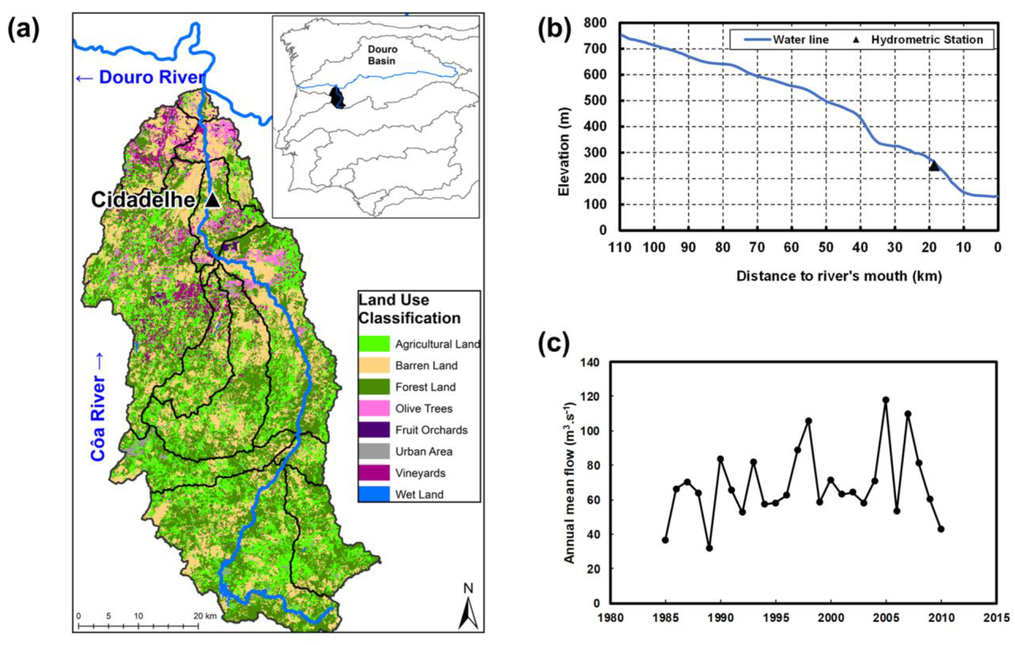
Figure 1. (a) Geographical representation of the Côa River basin in the Iberian Peninsula with the land cover classification. The river flow direction is represented by arrows near the river name. (b) Longitudinal profile of the river and relative position of the Cidadelhe gauged station. (c) Time series of the observed annual mean flow values at Cidadelhe for the period 1985–2010. The hydrometric station of Cidadelhe is also shown.
Water 15 02739 g001
Figure 3. Scatterplots showing the observed and simulated monthly mean streamflow (normalized) for each model over the historical period (1985–2010). Determination coefficients (R-squared metrics) are also shown for each model.
Water 15 02739 g003
Figure 4. Monthly mean streamflow (normalized) for the recent-past and future periods (1985–2014, 2040–2069, and 2070–2099). The lines represent the average for each period.
Water 15 02739 g004
Figure 5. (a) Time series of normalized mean annual flow for the ensemble means of the three selected climate model runs, for 1985–2014, 2040–2069, and 2070–2099. (b) Corresponding boxplots for each period.
Water 15 02739 g005
Figure 6. Representation of the baseline and future irrigation scenarios (10–50% increase), along with the simulated streamflow, under RCP8.5 and for each decade in the entire future period (2040–2099).
Water 15 02739 g006
Table 1. Characterization of the land use types in the Côa River basin.
Land Use TypeArea (ha)Total (%)
Forest Land89,98135.7
Barren Land73,28029.1
Agricultural Land (annual crops, pastures)60,15523.9
Vineyard11,4844.6
Olive91513.6
Urban Land50212.0
Orchards (nut trees)16440.7
Wetland12130.5
Total251,929100
Table 2. Global climate models and associated regional climate models selected.
Global Climate Model (GCM)Regional Climate Model (RCM)ABREV
CNRM-CERFACS-CNRM-CM5CLMcom-CCLM4-8-17CCLM
MPI-M-MPI-ESM-LSMHI-RCA4MPISMHI
IHCEC-EC-EARTHDMI-HIRHAM5IDMI
Table 3. Estimated irrigation requirements for each agricultural land use type in the Côa basin, based on [35].
Land Use TypeArea (ha)Irrigated Area (Country Ref. 15.9%)Annual Irrigation Requirements
(m3·ha−1·yr−1)
Annual Irrigation Requirements per Hectare (hm3·yr−1)
Agricultural land60,1559565400038
Vineyards11,484182620004
Olive9151145520003
Orchards
(mostly nut trees)
164426120001
Total82,43413,10710,00046
Disclaimer/Publisher’s Note: The statements, opinions and data contained in all publications are solely those of the individual author(s) and contributor(s) and not of MDPI and/or the editor(s). MDPI and/or the editor(s) disclaim responsibility for any injury to people or property resulting from any ideas, methods, instructions or products referred to in the content.