
Morphometric Determination and Digital Geological Mapping by RS and GIS Techniques in Aseer–Jazan Contact, Southwest Saudi Arabia


Abstract
1. Introduction
2. Study Area
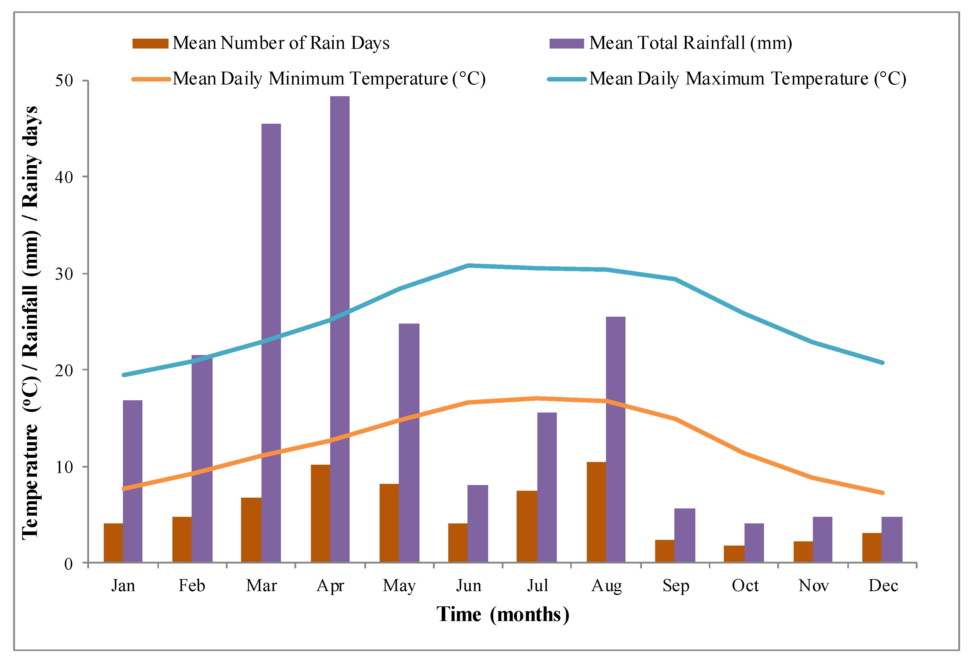
2.1. Hydrogeology
2.2. Water Demand vs. Supply
3. Materials and Methods
4. Results and Discussion
4.1. Drainage Basins
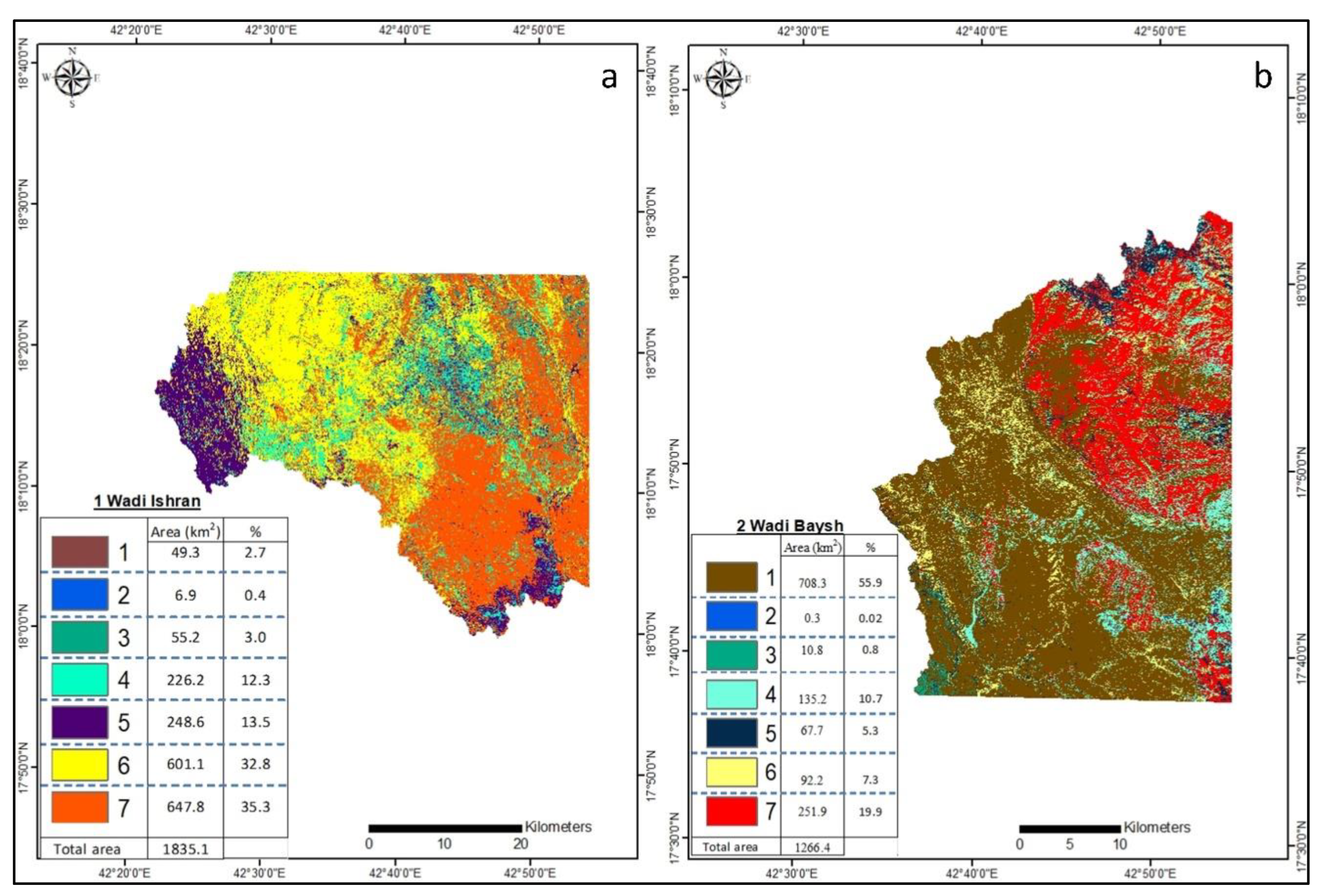
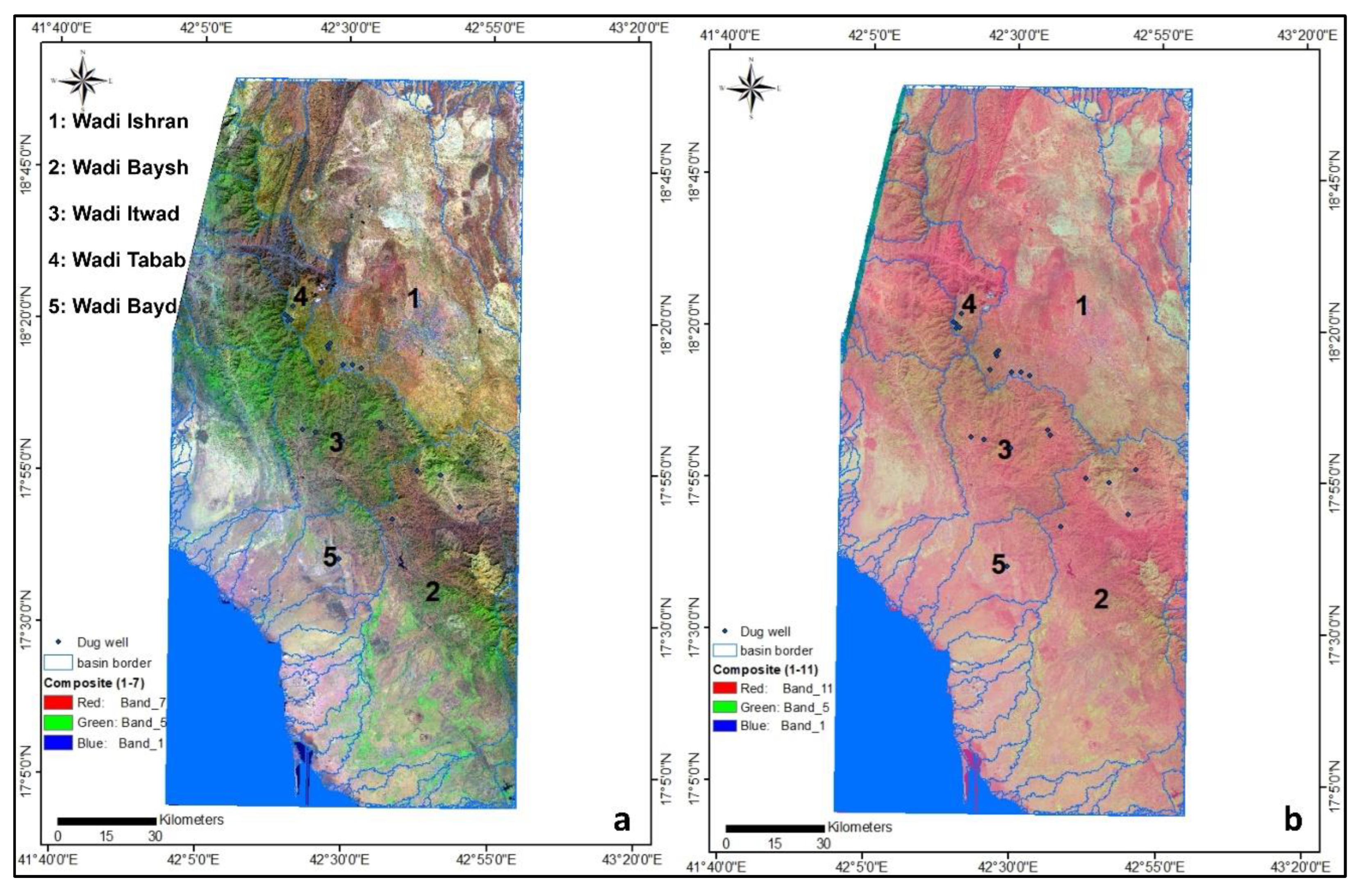
4.1.1. Ishran Basin
4.1.2. Baysh Basin
4.1.3. Wadi Itwad
4.1.4. Wadi Tabab
4.1.5. Wadi Bayd
4.2. Morphometric Analysis
4.2.1. Stream Order (u)
4.2.2. Stream Number (Nu)
4.2.3. Stream Length (Lu)
4.2.4. Mean Stream Length (Lum) and Stream Length Ratio (Lur)
4.2.5. Bifurcation Ratio (Rb)
4.2.6. Rho Coefficient (ρ)
4.2.7. Drainage Area (A) and Perimeter (P)
4.2.8. Circularity Ration (Rc)
4.2.9. Compactness Coefficient (Cc)
4.2.10. Length Area Relation (Lar)
4.2.11. Drainage Density (Dd)
4.2.12. Length of Overland Flow (Lg)
4.2.13. Stream Frequency (Fs)
4.2.14. Infiltration Number (IF)
4.2.15. Drainage Texture (T)
4.2.16. Constant of Channel Maintenance (C)
4.3. Aquifer Potentiality
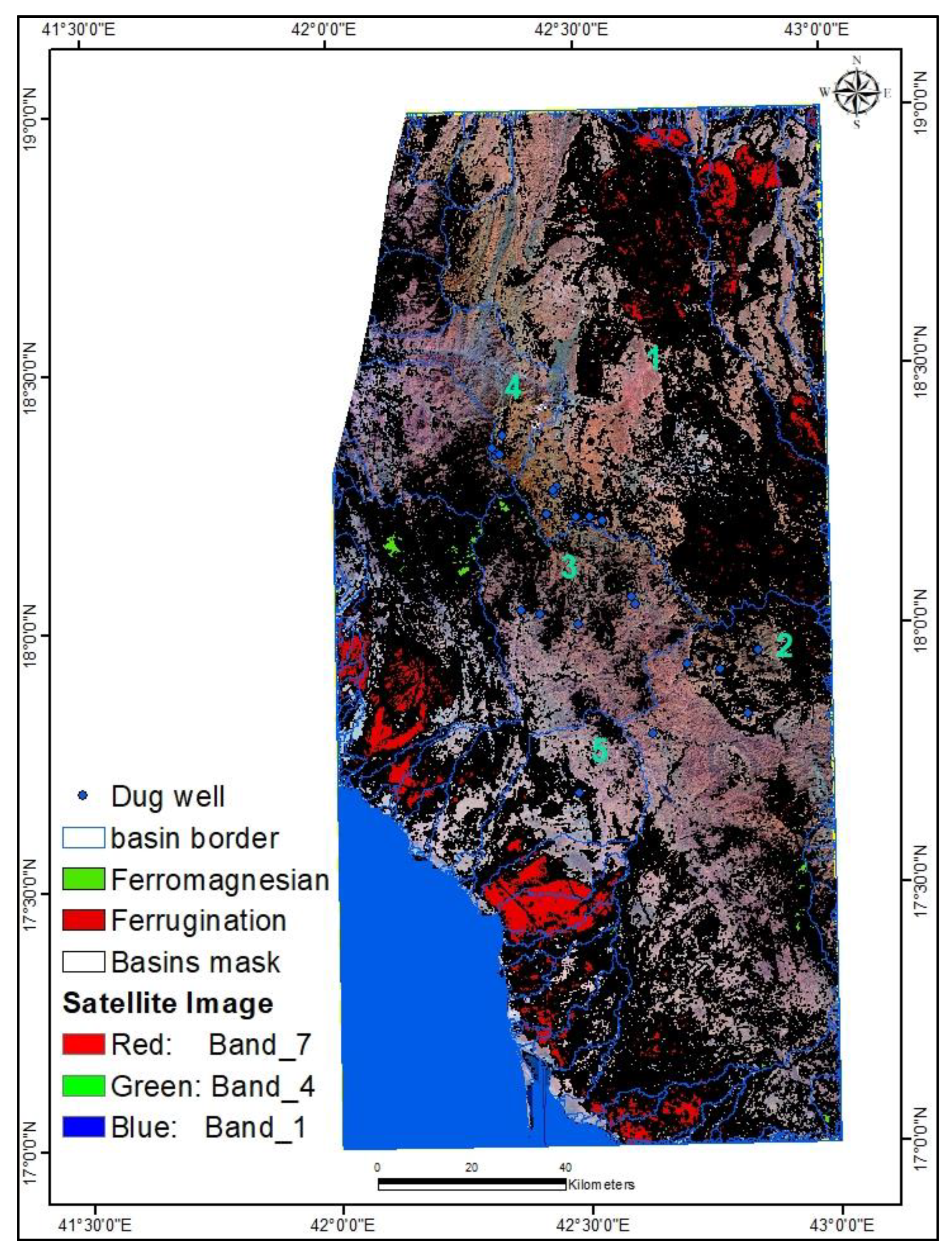
4.4. Remote Sensing
4.4.1. Multispectral Classification
4.4.2. Band Composite and NDVI
4.4.3. Landsat Oli 8 Band Ratio (BR) and Colour Composite Images
5. Conclusions and Recommendation
Supplementary Materials
Author Contributions
Funding
Data Availability Statement
Acknowledgments
Conflicts of Interest
References
- Adelodun, B.; Ajibade, F.O.; Ighalo, J.O.; Odey, G.; Ibrahim, R.G.; Kareem, K.Y.; Bakare, H.O.; Tiamiyu, A.O.; Ajibade, T.F.; Abdulkadir, T.S.; et al. Assessment of socioeconomic inequality based on virus-contaminated water usage in developing countries: A review. Environ. Res. 2021, 192, 110309. [Google Scholar] [CrossRef]
- Pandey, B.; Pathak, J.; Singh, P.; Kumar, R.; Kumar, A.; Kaushik, S.; Thakur, T.K. Microplastics in the Ecosystem: An Overview on Detection, Removal, Toxicity Assessment, and Control Release. Water 2022, 15, 51. [Google Scholar] [CrossRef]
- Agbasi, J.C.; Chukwu, C.N.; Nweke, N.D.; Uwajingba, H.C.; Khan MY, A.; Egbueri, J.C. Water pollution indexing and health risk assessment due to PTE ingestion and dermal absorption for nine human populations in Southeast Nigeria. Groundw. Sustain. Dev. 2023, 21, 100921. [Google Scholar] [CrossRef]
- Khan MY, A.; ElKashouty, M.; Abdellattif, A.; Egbueri, J.C.; Taha, A.I.; Al Deep, M.; Shaaban, F. Influence of natural and anthropogenic factors on the hydrogeology and hydrogeochemistry of Wadi Itwad Aquifer, Saudi Arabia: Assessment using multivariate statistics and PMWIN simulation. Ecol. Indic. 2023, 151, 110287. [Google Scholar] [CrossRef]
- Khan MY, A.; ElKashouty, M.; Khan, N.; Subyani, A.M.; Tian, F. Spatio-temporal evaluation of trace element contamination using multivariate statistical techniques and health risk assessment in groundwater, Khulais, Saudi Arabia. Appl. Water Sci. 2023, 13, 123. [Google Scholar] [CrossRef]
- Khan MY, A.; ElKashouty, M.; Zaidi, F.K.; Egbueri, J.C. Mapping Aquifer Recharge Potential Zones (ARPZ) Using Integrated Geospatial and Analytic Hierarchy Process (AHP) in an Arid Region of Saudi Arabia. Remote Sens. 2023, 15, 2567. [Google Scholar] [CrossRef]
- Food and Agriculture Organization of the United Nation (FAO). Saudi Arabia irrigation in the Middle East regions in figure. Aquatat Survey 2008. In Land FAO and Water Division Report; Freken, K., Ed.; FAO: Rome, Italy, 2009; Volume 34, pp. 325–337. [Google Scholar]
- Khan MY, A.; El Kashouty, M.; Gusti, W.; Kumar, A.; Subyani, A.M.; Alshehri, A. Geo-temporal signatures of physicochemical and heavy metals pollution in Groundwater of Khulais region—Makkah Province, Saudi Arabia. Front. Environ. Sci. 2022, 9, 699. [Google Scholar] [CrossRef]
- Ouda, O.K.M.; Shawesh, A.; Al-Olabi, T.; Younes, F.; Al-Waked, R. Review of domestic water conservation practices in Saudi Arabia. Appl. Water Sci. 2013, 3, 689–699. [Google Scholar] [CrossRef]
- Okada, K.; Ishii, M. Mineral and lithological mapping using thermal infrared remotely sensed data from ASTER simulator. In Proceedings of the International Geosciences and Remote Sensing Symposium Better Understanding of Earth Environment, Tokyo, Japan, 18–21 August 1993; Volume 93, pp. 126–128. [Google Scholar]
- Bedell, R.L. Geological mapping with ASTER satellite: New global satellite data that is a significant leap in remote sensing geologic and alteration mapping. Spec. Publ. Geo. Soc. Nev. 2001, 33, 329–334. [Google Scholar]
- Vincent, P. Saudi Arabia: An Environmental Overview; Taylor and Francis: London, UK, 2008. [Google Scholar] [CrossRef]
- Khan MY, A.; ElKashouty, M.; Subyani, A.M.; Tian, F.; Gusti, W. GIS and RS intelligence in delineating the groundwater potential zones in Arid Regions: A case study of southern Aseer, southwestern Saudi Arabia. Appl. Water Sci. 2022, 12, 3. [Google Scholar] [CrossRef]
- Crósta, A.P.; Filho, C.R.d.S. Searching for gold with ASTER. Earth Obs. Mag. 2003, 12, 38–41. [Google Scholar]
- Khan MY, A.; ElKashouty, M.; Tian, F. Mapping Groundwater Potential Zones Using Analytical Hierarchical Process and Multicriteria Evaluation in the Central Eastern Desert, Egypt. Water 2022, 14, 1041. [Google Scholar] [CrossRef]
- Dimple, D.; Rajput, J.; Al-Ansari, N.; Elbeltagi, A.; Zerouali, B.; Santos CA, G. Determining the Hydrological Behaviour of Catchment Based on Quantitative Morphometric Analysis in the Hard Rock Area of Nand Samand Catchment, Rajasthan, India. Hydrology 2022, 9, 31. [Google Scholar] [CrossRef]
- Yangchan, J.; Jain, A.K.; Tiwari, A.K.; Sood, A. Morphometric Analysis of Drainage Basin through GIS: A Case study of Sukhna Lake Watershed in Lower Shiwalik, India. Int. J. Sci. Eng. Res. 2015, 6, 1015–1023. [Google Scholar]
- Strahler, A.N. Quantitative Geomorphology of drainage basins and channel networks. In Handbook of Applied Hydrology; Chow, V.T., Ed.; McGraw-Hill: New York, NY, USA, 1964; pp. 439–476. [Google Scholar]
- Horton, R.E. Erosional Development of Streams and Their Drainage Basins. hydrophysical approach to quantitative morphology. Bull. Geol. Soc. Am. 1945, 56, 275–370. [Google Scholar] [CrossRef]
- Prakash, K.; Rawat, D.; Singh, S. Morphometric analysis using SRTM and GIS in synergy with depiction: A case study of the Karmanasa River basin, North central India. Appl. Water Sci. 2019, 9, 13. [Google Scholar] [CrossRef]
- Markose, V.J.; Dinesh, A.; Jayappa, K. Quantitative analysis of morphometric parameters of Kali River basin, southern India, using bearing azimuth and drainage (bAd) calculator and GIS. Environ. Earth Sci. 2014, 72, 2887–2903. [Google Scholar] [CrossRef]
- Benukantha, D.; Nagaraju, M.S.S.; Sahu, N.; Nasre, R.A.; Mohekar, D.S.; Srivastava, R.; Singh, S.K. Morphometric Analysis for Planning Soil and Water Conservation Measures Using Geospatial Technique. Int. J. Curr. Microbiol. App. Sci. 2019, 8, 2719–2728. [Google Scholar] [CrossRef]
- John Wilson, J.S.; Chandrasekar, N.; Magesh, N.S. Morphometric analysis of major sub-watersheds in Aiyar and Karai Pottanar Basin, central Tamil Nadu, India usingremote sensing and GIS techniques. Bonfring. Int. J. Ind. Eng. Manag. Sci. 2012, 2, 8–15. [Google Scholar]
- Prakash, K.; Singh, S.; Shukla, U.K. Morphometric changes of the Varuna river basin, Varanasi district, Uttar Pradesh. J. Geom. 2016, 10, 48–54. [Google Scholar]
- Perucca, P.L.; Angilieri, E.Y. Morphometric characterization of Del Molle basin applied to the evaluation of flash floods hazard, Iglesia Department, San Juan, Argentina. Quatern. Int. 2011, 233, 81–86. [Google Scholar] [CrossRef]
- Soni, S. Assessment of morphometric characteristics of Chakra watershed in Madhya Pradesh India using the geospatial technique. Appl. Water Sci. 2016, 7, 2089–2102. [Google Scholar] [CrossRef]
- Kaushik, P.; Ghosh, P. Morphometric analysis of Mej subbasin, Rajasthan, India, using remote sensing and GIS applications. Int. J. Create. Res. Thoughts 2018, 6, 1379–1392. [Google Scholar]
- Puno, G.R.; Puno, R.C.C. Watershed conservation prioritization using geomorphometric and land use-land cover parameters. Glob. J. Environ. Sci. Manag. 2019, 5, 279–294. [Google Scholar] [CrossRef]
- Bharath, A.; Kumar, K.K.; Maddamsetty, R.; Manjunatha, M.; Tangadagi, R.B.; Preethi, S. Drainage morphometry based sub-watershed prioritization of Kalinadi basin using geospatial technology. Environ. Chall. 2021, 5, 100277. [Google Scholar] [CrossRef]
- Benzougagh, B.; Meshram, S.G.; Dridri, A.; Boudad, L.; Baamar, B.; Sadkaoui, D.; Khedher, K.M. Identification of critical watersheds at risk of soil erosion using morphometric and geographic information system analysis. Appl. Water Sci. 2022, 12, 8. [Google Scholar] [CrossRef]
- Abboud, I.A.; Nofal, R.A. Morphometric analysis of wadi Khumal basin, western coast of Saudi Arabia, using remote sensing and GIS techniques. J. Afr. Earth Sci. 2017, 126, 58–74. [Google Scholar] [CrossRef]
- Bajabaa, S.; Masoud, M.; Al-Amri, N. Flash flood hazard mapping based on quantitative hydrology, geomorphology and GIS techniques (case study of wadi Al Lith, Saudi Arabia). Arab. J. Geosci. 2014, 7, 2469–2481. [Google Scholar] [CrossRef]
- Mahmoud, S.H.; Alazba, A.A. Geomorphological and geophysical information system analysis of major rainwater-harvesting basins in Al-Baha region, Saudi Arabia. Arab. J. Geosci. 2015, 8, 9959–9971. [Google Scholar] [CrossRef]
- Singh, S.; Singh, A.K.; Kumar, P.; Jaiswal, M.K. Morphotectonic analysis of the Bihar River, Madhya Pradesh, India. Proc. Indian Natl. Sci. Acad. 2021, 87, 163–174. [Google Scholar] [CrossRef]
- Bashar, B. Morphometric Parameters and Geospatial Analysis for Flash Flood Susceptibility Assessment: A Case Study of Jeddah City along the Red Sea Coast, Saudi Arabia. Water 2023, 15, 870. [Google Scholar] [CrossRef]
- Subyani, A.M. Hydrogeological and Hydrochemical Features of Wadi Adam, Makkah Al-Mukarramah Area. Earth Sci. 2005, 16, 1012–8832. [Google Scholar] [CrossRef]
- Khan, M.Y.A.; ElKashouty, M.; Bob, M. Impact of rapid urbanization and tourism on the groundwater quality in Al Madinah city, Saudi Arabia: A monitoring and modeling approach. Arab. J. Geosci. 2020, 13, 922. [Google Scholar] [CrossRef]
- Biswas, M.R.; Chakraborty, S. Watershed prioritization based on geo-morphometry and land use parameters–an approach to watershed development using remote sensing and GIS, Neora Watershed, Darjeeling and Jalpaiguri Districts, West Bengal, India. J. Appl. Geol. Geophys. 2016, 4, 36–49. [Google Scholar]
- Benzougagh, B.; Dridri, A.; Boudad, L.; Kodad, O.; Sdkaoui, D.; Bouikbane, H. Evaluation of natural hazard of Inaouene watershed river in northeast of Morocco: Application of morphometric and geographic information system approaches. Int. J. Innov. Appl. Stud. 2017, 19, 85–97. [Google Scholar]
- Meshram, S.G.; Meshram, C.; Abul Hasan, M.; Khan, M.A.; Islam, S. Morphometric deterministic model for prediction of sediment yield index for selected watersheds in upper Narmada Basin. Appl. Water Sci. 2022, 12, 153. [Google Scholar] [CrossRef]
- Al-Ibrahim, A.A. Excessive use of groundwater resources in Saudi Arabia: Impacts and policy options. Ambio 1991, 20, 34–37. [Google Scholar]
- MWE. Supporting Documents for King Hassan II Great Water Prize. 2012. Available online: http://www.worldwatercouncil.org/fileadmin/wwc/Prizes/Hassan_II/Candidates_2011/16.Ministry_ (accessed on 16 November 2022).
- World Bank. A Water Sector Assessment Report on Countries of the Cooperation Council of the Arab State of the Gulf; Report No. 32539-MNA; World Bank: Washington, DC, USA, 2005. [Google Scholar]
- Ouda, O. Water demand versus supply in Saudi Arabia: Current and future challenges. Int. J. Water Resour. Dev. 2014, 30, 335–344. [Google Scholar] [CrossRef]
- Raj, N.J.; Prabhakaran, A.; Muthukrishnan, A. Quantitative stream network analysis for assessing form and hydrological processes of the watersheds of Kolli hills, Tamil Nadu, India. Arab. J. Geosci. 2021, 14, 2646. [Google Scholar] [CrossRef]
- Odiji, C.A.; Aderoju, O.M.; Eta, J.P.; Shehu, I.; Mai-Bukar, A.; Onuoha, H. Morphometric analysis and prioritization of upper Benue River watershed, Northern Nigeria. Appl. Water Sci. 2021, 11, 41. [Google Scholar] [CrossRef]
- Kaushik, P.; Ghosh, P. 3D DEM delineation of Chambal river basin from SRTM data using remote sensing and GIS technology. Int. J. Remote Sens. Geosci. 2015, 4, 1–6. [Google Scholar]
- Patel, A.; Katiyar, K.S.; Prasad, V. Performances evaluation of different open source DEM using diferential global positioning system (DGPS). Egypt. J. Remote Sens. Space Sci. 2016, 19, 7–16. [Google Scholar]
- Asfaw, D.; Workineh, G. Quantitative analysis of morphometry on Ribb and Gumara watersheds: Implications for soil and water conservation. Int. Soil Water Conserv. Res. 2021, 7, 150–157. [Google Scholar] [CrossRef]
- Torrefranca, T.; Otadoyc, R.E. GIS-based watershed characterization and morphometric analysis in Bohol Watersheds, Philippines. Geol. Ecol. Landsc. 2022. [Google Scholar] [CrossRef]
- Masoud, M.H.; Basahi, J.M.; Rajmohan, N. Impact of flash flood recharge on groundwater quality and its suitability in the Wadi Baysh Basin, Western Saudi Arabia: An integrated approach. Environ. Earth Sci. 2018, 77, 395. [Google Scholar] [CrossRef]
- Karim, A.A. Assessment of the Expected Flood Hazards of the Jizan-Abha Highway, Kingdom of SaudiArabia by Integrating Spatial-Based Hydrologic and Hydrodynamic Modeling. Glob. J. Res. Eng. 2019, 19, 27–35. [Google Scholar]
- Strahler, A.N. Quantitative Analysis of Watershed Geomorphology. Transactions. Am. Geophys. Union 1957, 38, 913–920. [Google Scholar] [CrossRef]
- Gajbhiye, S.; Mishra, S.K.; Pandey, A. Prioritizing erosion-prone area through morphometric analysis: An RS and GIS perspective. Appl. Water Sci. 2015, 4, 51–61. [Google Scholar] [CrossRef]
- Gutema, D.; Kassa, T.; Sifan, A.K. Morphometric Analysis to Identify Erosion Prone Areas on The Upper Blue Nile Using Gis (Case Study of Didessa and Jema Sub-Basin, Ethiopia). Int. Res. J. Eng. Technol. 2017, 4, 1773–1784. [Google Scholar]
- Subba Rao, N. A numerical scheme for groundwater development in a watershed basin of basement terrain: A case study from India. Hydrogeol. J. 2009, 17, 379–396. [Google Scholar] [CrossRef]
- Ghosh, M.; Gope, D. Hydro-morphometric characterization and prioritization of sub-watersheds for land and water resource management using fuzzy analytical hierarchical process (FAHP): A case study of upper Rihand watershed of Chhattisgarh State, India. Appl. Water Sci. 2021, 11, 17. [Google Scholar] [CrossRef]
- Biswas, S.S. Analysis of GIS Based Morphometric Parameters and Hydrological Changes in Parbati River Basin, Himachal Pradesh, India. J. Geogr. Nat. Disast. 2016, 6, 175. [Google Scholar] [CrossRef]
- Avijit, M. The significance of morphometric analysis to understand the hydrological and morphological characteristics in two different morpho climatic settings. Appl. Water Sci. 2020, 10, 33. [Google Scholar] [CrossRef]
- Dubey, S.K.; Sharma, D.; Mundetia, N. Morphometric Analysis of the Banas River Basin Using Geographical Information System, Rajasthan, India. Hydrology 2015, 3, 47–57. [Google Scholar] [CrossRef]
- Nageswara, R.K.; Swarna, L.P.; Arun, K.P.; Hari, K.M. Morphometric Analysis of Gostani River Basin in Andhara Pradesh State, India Using Spatial Information Technology. Int. J. Geomat. Geosci. 2010, 1, 179–187. [Google Scholar]
- López-Pérez, A.; Fernández-Reynoso, D.S. Watershed prioritization using morphometric analysis and vegetation index: A case study of Huehuetan river sub-basin, Mexico. Arab. J. Geosci. 2021, 14, 1852. [Google Scholar] [CrossRef]
- Magesh, N.; Jitheshlal, K.; Chandrasekar, N.; Jini, K. Geographical information system based morphometric analysis of Bharathapuzha river basin, Kerala, India. Appl. Water Sci. 2013, 3, 467–477. [Google Scholar] [CrossRef]
- Sreedevi, P.D.; Subrahmanyam, K.; Ahmed, S. The significance of morphometric analysis for obtaining groundwater potential zones in a structurally controlled terrain. Environ. Geol. 2004, 47, 412–420. [Google Scholar] [CrossRef]
- Yadav, S.K.; Singh, S.K.; Gupta, M.; Srivastava, P.K. Morphometric analysis of Upper Tons basin from Northern Foreland of Peninsular India using CARTOSAT satellite and GIS. Geocarto Int. 2014, 29, 895–914. [Google Scholar] [CrossRef]
- Nag, S.K.; Chakraborty, S. Influence of rock type and structure development of drainage network in hard rock terrain. J. Indian Soc. Remote Sens. 2003, 31, 25–35. [Google Scholar] [CrossRef]
- Rawat, K.S.; Mishra, A.K.; Tripathi, V.K. Hydro-morphometrical analyses of sub-himalyan region in relation to small hydro-electric power. Arab. J. Geosci. 2012, 6, 2889–2899. [Google Scholar] [CrossRef]
- Ajaykumar, K.K.; Tasadoq, H.J.; Sanjay, S.K.; Bhavana, N.U.; Rabindranath, N.S. Identification of erosion-prone areas using modified morphometric prioritization method and sediment production rate: A remote sensing and GIS approach. Geomat. Nat. Hazards Risk 2019, 10, 986–1006. [Google Scholar] [CrossRef]
- Chow, V.T. Handbook of Applied Hydrology; McGraw-Hill: New York, NY, USA, 1964. [Google Scholar]
- Kanhaiya, S.; Singh, B.P.; Singh, S.; Mittal, P.; Srivastava, V.K. Morphometric analysis, bed-load sediments and weathering intensity in the Khurar River Basin, Central India. Geol. J. 2019, 54, 466–481. [Google Scholar] [CrossRef]
- Harinath, V.; Raghu, V. Morphometric Analysis using Arc GIS Techniques A Case Study of Dharurvagu, South Eastern Part of Kurnool District, Andhra Pradesh, India. Int. J. Sci. Res. 2013, 2, 182–187. [Google Scholar]
- Pande, C.B.; Moharir, K.N.; Khadri SF, R. Watershed planning and development based on morphometric analysis and remote sensing and GIS techniques: A case study of semi-arid watershed in Maharashtra, India. In Groundwater Resources Development and Planning in the Semi-Arid Region; Springer: Cham, Switzerland, 2021; pp. 199–220. [Google Scholar]
- Gravelius, H. Flusskunde. Goschen Verlagshan dlung Berlin. In Morphometry of Drainage Basins; Zavoianu, I., Ed.; Elsevier: Amsterdam, The Netherlands, 1941. [Google Scholar]
- Hack, J.T. Studies in Longitudinal Stream Profiles in Virginia and Maryland; US Geological Survey Professional Paper 249-B; US Government Printing Office: Washington, DC, USA, 1957; pp. 45–97.
- Millar, J.P. High mountaineous streams Effect of geology on channel characteristics and bed material, Mem. New Maxico Bur. Mines Mineral. Resource 1958, 4, 1–51. [Google Scholar]
- Miller, O.M.; Summerson, C.H. Slope zone map. Geogr. Rev. 1960, 50, 194–202. [Google Scholar] [CrossRef]
- Chorley, R.J. Introduction to Physical Hydrology; Methuen and Co. Ltd.: Suffolk, UK, 1969; p. 211. [Google Scholar]
- Prasad, G. Environmental Geomorphology; Discovery Publishing House: New Delhi, India, 2008. [Google Scholar]
- Jasmin, I.; Mallikarjuna, P. Morphometric analysis of Araniar river basin using remote sensing and geographical information system in the assessment of groundwater potential. Arab. J. Geosci. 2013, 6, 3683–3692. [Google Scholar] [CrossRef]
- Smith, K.G. Standards for grading textures of erosional topography. Am. J. Sci. 1950, 248, 655–668. [Google Scholar] [CrossRef]
- Albaroot, M.; Nabil MAl Hamdi, S.A.; Mohammed, A.; Saleh, A.G. Quantification of Morphometric Analysis using Remote Sensing and GIS Techniques in the Qa’ Jahran Basin, Thamar Province, Yemen. Int. J. New Technol. Res. 2018, 4, 12–22. [Google Scholar]
- Schumm, S.A. Evolution of drainage systems and slopes in badlands at Perth Amboy, New Jersey. Geol. Soc. Am. Bull. 1956, 67, 597–646. [Google Scholar] [CrossRef]
- Singh, P.; Gupta, A.; Singh, M. Hydrological inferences from the watershed analysis of water resource management using remote sensing and techniques. Egypt J. Remote Sens. Space Sci. 2014, 17, 111–121. [Google Scholar] [CrossRef]
- Mohammed, O.A.; Sayl, K.N. Determination of Groundwater potential zone in arid and semi-arid regions: A review. In Proceedings of the 2020 13th International Conference on Developments in eSystems Engineering (DeSE), Virtual Conference, 14–17 December 2020; IEEE: New York, NY, USA, 2020; pp. 76–81. [Google Scholar]
- Mohammed, S.S.; Sayl, K.N.; Kamel, A.H. Ground water recharge mapping in Iraqi Western desert. Int. J. Des. Nat. Ecodyn. 2022, 17, 913–920. [Google Scholar] [CrossRef]
- Mohammed, O.A.; Sayl, K.N. A GIS-based multicriteria decision for groundwater potential zone in the west desert of Iraq. In IOP Conference Series: Earth and Environmental Science; IOP Publishing: Bristol, UK, 2021; Volume 856, p. 012049. [Google Scholar]
- Lecia Geosystems & GIS Mapping Division. Erdas Field Guide, 7th ed; Erdas LLC.: Atlanta, GA, USA, 2003; 698p. [Google Scholar]
- Lillesand, T.M.; Kiefer, R.W. Remote Sensing and Image Interpretation, 4th ed.; John Wiley & Sons, Inc.: New York, NY, USA, 2000; 724p. [Google Scholar]
- Blank, R.; Johnson, P.; Gettings, M.; Simmons, G. Explanatory Notes to the Geologic Map of the Jazan Quadrangle; Deputy Minister for Mineral Resources: Jiddah, Saudi Arabia, 1985; p. 24.
- Mogren, S.; Batayneh, A.; Elawadi, E.; Al-Bassam, A.; Ibrahim, E.; Qaisy, S. Aquifer boundaries explored by geoelectrical measurements in the Red Sea coastal plain of Jazan area, South west Saudi Arabia. Int. J. Phys. Sci. 2011, 6, 3768–3776. [Google Scholar]
- Basahel, A.; Bahafzalla, A.; Mansour, H.; Omara, S. Primary structures and depositional environ of the Haddat Ash Sham sedimentary sequence, northwest of Jeddah, Saudi Arabia Arab Gulf. J. Sci. Res. 1983, 1, 143–155. [Google Scholar]
- Hussain, M.; Ibrahim, K. Electric resistivity, geochemical and hydrogeological of Wadi deposits, Western Saudi Arabia. J. King Abdel Aziz Univ. Earth Sci. 1997, 9, 55–72. [Google Scholar]
- Drury, S.A. Image Interpretation in Geology, 2nd ed.; Chapman & Hall: New York, NY, USA, 1993; xii 271–283p. [Google Scholar]
- Lillesand, T.M.; Kiefer, R.W. Remote Sensing and Image Interpretation, 3rd ed.; John Wiley & Sons: Hoboken, NJ, USA, 1994; pp. xvi + 750. [Google Scholar] [CrossRef]
- Gupta, R.P. Remote Sensing Geology; Springer: Berlin/Heidelberg, Germany, 1991; pp. xvi + 356. [Google Scholar] [CrossRef]


| Number of Streams (NuT) of Different Stream Order (u) | Total Stream Lengths LuT (km) | ||||||||||||||
|---|---|---|---|---|---|---|---|---|---|---|---|---|---|---|---|
| Basin No. | I | II | III | IV | V | VI | ∑NuT | Basin No. | I | II | III | IV | V | VI | ∑LuT, km |
| 1-Wadi Ishran | 998 | 221 | 46 | 11 | 1 | 1 | 1278 | 1 | 1707.7 | 252.3 | 92.2 | 9.6 | 0.4 | 1.2 | 2063.4 |
| 2-Wadi Baysh | 815 | 177 | 33 | 9 | 1 | 2 | 1037 | 2 | 1393.5 | 674.4 | 457.3 | 130.3 | 148.2 | 9.5 | 2823.2 |
| 3-Wadi Itwad | 381 | 82 | 18 | 4 | 1 | 486 | 3 | 623.2 | 310.5 | 43.3 | 60.6 | 77 | 1114.6 | ||
| 4-Wadi Tabab | 135 | 28 | 4 | 1 | 168 | 4 | 214.9 | 89.8 | 58.8 | 40.6 | 404.1 | ||||
| 5-Wadi Bayd | 155 | 34 | 7 | 4 | 1 | 201 | 5 | 276 | 138.4 | 96.3 | 31.5 | 27.3 | 293.5 | ||
| ∑ Nu | 2484 | 542 | 108 | 29 | 4 | 3 | Total Nu = 3170 | ∑Lu, km | 3939.3 | 1465.4 | 747.9 | 272.6 | 252.9 | 10.7 | Total Lu = 6688.8 |
| Mean stream length, Lum (km) | Stream length ratio, Lur | ||||||||||||||
| Basin No. | I | II | III | IV | V | VI | II/I | III/II | IV/III | V/IV | VI/V | Mean Lur | |||
| 1-Wadi Ishran | 1.71 | 1.14 | 2 | 0.87 | 0.4 | 1.2 | 0.67 | 1.76 | 0.44 | 0.46 | 3 | 1.26 | |||
| 2-Wadi Baysh | 1.71 | 3.81 | 13.86 | 14.48 | 148 | 4.75 | 2.23 | 3.64 | 1.04 | 10.24 | 0.03 | 3.44 | |||
| 3-Wadi Itwad | 1.64 | 3.79 | 2.41 | 15.15 | 77 | 2.31 | 0.64 | 6.3 | 5.08 | 3.6 | |||||
| 4-Wadi Tabab | 1.59 | 3.21 | 14.7 | 40.6 | 2.01 | 4.58 | 2.76 | 3.1 | |||||||
| 5-Wadi Bayd | 1.8 | 4.07 | 13.76 | 7.88 | 27.3 | 2.3 | 3.38 | 0.57 | 3.47 | 2.4 | |||||
| Basin No. | Bifurcation Ratio Rb (Nu/Nu + 1) | Mean Rb | Rho Coefficient (ρ) | ||||
|---|---|---|---|---|---|---|---|
| (Rbm) | |||||||
| I/II | II/III | III/IV | IV/V | V/VI | |||
| 1-Wadi Ishran | 4.52 | 4.80 | 4.18 | 11.00 | 1.00 | 5.10 | 0.25 |
| 2-Wadi Baysh | 4.61 | 5.36 | 3.67 | 9.00 | 0.50 | 4.60 | 0.75 |
| 3-Wadi Itwad | 4.65 | 4.56 | 4.50 | 4.00 | 4.40 | 0.82 | |
| 4-Wadi Tabab | 4.82 | 7.00 | 4.00 | 5.30 | 0.58 | ||
| 5-Wadi Bayd | 4.56 | 4.86 | 1.75 | 4.00 | 3.80 | 0.63 | |
| Basin No. | Area “A” (Km2) | Perimeter “P” (Km) | Circularity Ratio (Rc) | Compactness Coefficient (Cc) | Length–Area Relation (Lar) |
|---|---|---|---|---|---|
| 1-Wadi Ishran | 5022.9 | 482.15 | 0.27 | 1.9 | 232.65 |
| 2-Wadi Baysh | 4109.77 | 463.55 | 0.24 | 2 | 206.26 |
| 3-Wadi Itwad | 1913.26 | 379.36 | 0.17 | 2.4 | 130.37 |
| 4-Wadi Tabab | 638.52 | 203.58 | 0.19 | 2.3 | 67.49 |
| 5-Wadi Bayd | 777.95 | 237.42 | 0.17 | 2.4 | 75.98 |
| Basin No. | Drainage Density “Dd”; Dd = ∑LuT/A (km/km2) | Length of Overland Flow “Lg”; Lg = l/2 Dd (km2/km) | Stream Frequency “F”; F = ∑NuT/A (km2) | Drainage Intensity “D”; Di = (F/Dd) | Infiltration No. “If”; If = F × Dd | Drainage Texture “T”; T = (Dd × F) | Constant of Channel Maintenance “C”; C = l/Dd (km2/km) |
|---|---|---|---|---|---|---|---|
| 1-Wadi Ishran | 0.41 | 0.21 | 0.25 | 0.62 | 0.1 | 0.1 | 2.43 |
| 2-Wadi Baysh | 0.69 | 0.34 | 0.25 | 0.37 | 0.17 | 0.17 | 1.46 |
| 3-Wadi Itwad | 0.58 | 0.29 | 0.25 | 0.44 | 0.15 | 0.15 | 1.72 |
| 4-Wadi Tabab | 0.63 | 0.32 | 0.26 | 0.42 | 0.17 | 0.17 | 1.58 |
| 5-Wadi Bayd | 0.38 | 0.19 | 0.26 | 0.68 | 0.1 | 0.1 | 2.65 |
Disclaimer/Publisher’s Note: The statements, opinions and data contained in all publications are solely those of the individual author(s) and contributor(s) and not of MDPI and/or the editor(s). MDPI and/or the editor(s) disclaim responsibility for any injury to people or property resulting from any ideas, methods, instructions or products referred to in the content. |
© 2023 by the authors. Licensee MDPI, Basel, Switzerland. This article is an open access article distributed under the terms and conditions of the Creative Commons Attribution (CC BY) license (https://creativecommons.org/licenses/by/4.0/).
Share and Cite
Khan, M.Y.A.; ElKashouty, M.; Subyani, A.M.; Tian, F. Morphometric Determination and Digital Geological Mapping by RS and GIS Techniques in Aseer–Jazan Contact, Southwest Saudi Arabia. Water 2023, 15, 2438. https://doi.org/10.3390/w15132438
Khan MYA, ElKashouty M, Subyani AM, Tian F. Morphometric Determination and Digital Geological Mapping by RS and GIS Techniques in Aseer–Jazan Contact, Southwest Saudi Arabia. Water. 2023; 15(13):2438. https://doi.org/10.3390/w15132438
Chicago/Turabian StyleKhan, Mohd Yawar Ali, Mohamed ElKashouty, Ali Mohammad Subyani, and Fuqiang Tian. 2023. "Morphometric Determination and Digital Geological Mapping by RS and GIS Techniques in Aseer–Jazan Contact, Southwest Saudi Arabia" Water 15, no. 13: 2438. https://doi.org/10.3390/w15132438
APA StyleKhan, M. Y. A., ElKashouty, M., Subyani, A. M., & Tian, F. (2023). Morphometric Determination and Digital Geological Mapping by RS and GIS Techniques in Aseer–Jazan Contact, Southwest Saudi Arabia. Water, 15(13), 2438. https://doi.org/10.3390/w15132438