
Assessing Vulnerability of Regional-Scale Aquifer-Aquitard Systems in East Gulf Coastal Plain of Alabama by Developing Groundwater Flow and Transport Models

Abstract
:1. Introduction
2. Methodology and Model Development
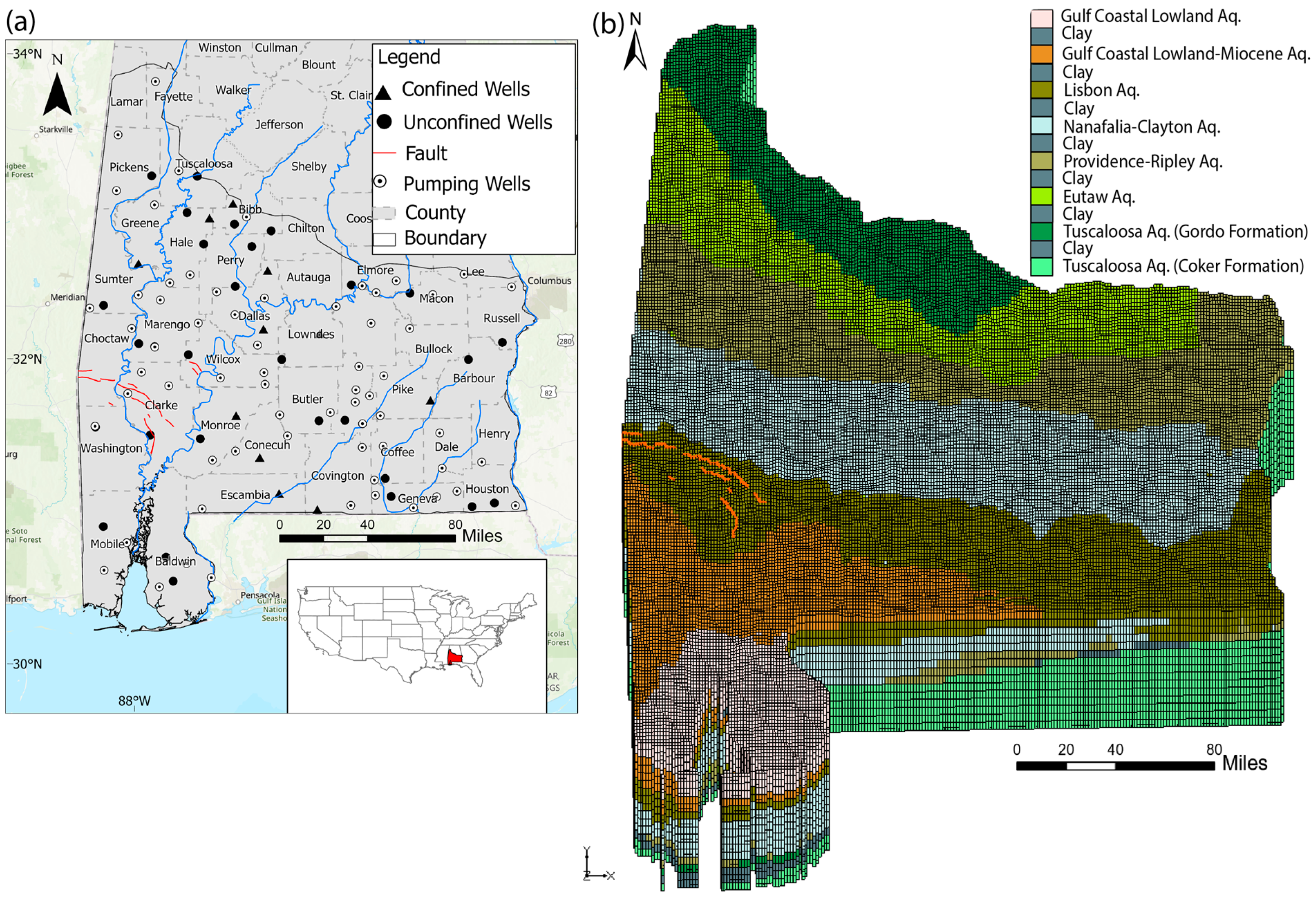
2.1. Study Site: Geology and Hydrogeology Conditions
2.2. Process-Based Numerical Models to Assess GWV
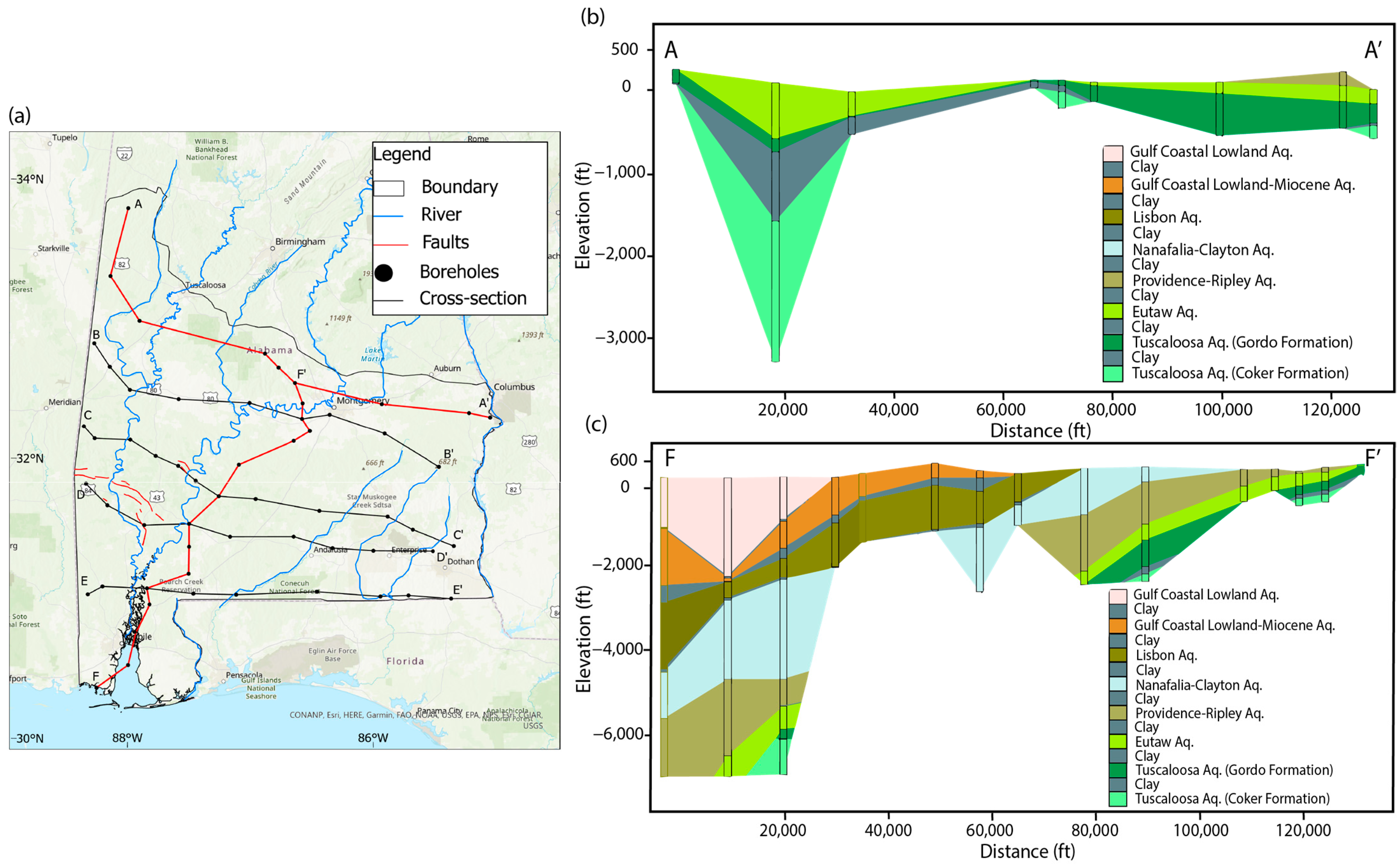
2.2.1. Geology Model for Southern Alabama Aquifers
- (1)
- (2)
- Gordo aquifer. The upper part of the Tuscaloosa Group is composed of the Gordo Formation, which is an important source of groundwater from northwest to east-central Alabama [49]. The Gordo Formation has an average thickness of 300 feet, but it thickens to 500 feet downdip [40]. A nonmarine clay layer in the upper section of the Gordo Formation serves as the confining unit above it [40].
- (3)
- Eutaw aquifer. Provides a significant amount of water for Alabama. Outcrops range in a thickness from 100 to150 ft in the eastern part of the state and 350 to 400 ft in the western part [49]. The Mooreville and Demopolis Chalks form the confining unit above this aquifer. The chalks extend until around Bullock County where they transition to sands and clays of the Blufftown Formation [40].
- (4)
- Providence-Ripley aquifer. The Ripley Formation has a thickness varying from 150 to 250 feet, and the Providence Sand exhibits a thickness increasing from less than 50 feet in Lowndes County to around 300 feet at the eastern boundary of Alabama [40]. It provides a significant groundwater source in south-central and east-central Alabama. There are 117 screened wells in the Ripley aquifer, and their depths vary from 18 ft (below land surface, or bls) in the outcrop area to 1045 ft bls downdip. The confining unit above this aquifer is made up of the Prairie Bluff Chalk, Clayton Formation, and Porters Creek Formation. Meanwhile, in the eastern part of the state, a marine clay layer located in the lower section of the Clayton Formation serves as the confining unit above [40].
- (5)
- Nanafalia-Clayton aquifer. The thickness of this aquifer varies from 250 ft in south-central and southwestern Alabama to 75 ft in southeast Alabama [50]. To the southwest of the state, the confining unit above consists of the Yazoo Clay. In other regions, the confining unit is made up of silt, clay, and clayey sand located near the middle of the Tuscahoma Formation [40].
- (6)
- Lisbon aquifer. Provides the significant public, domestic, agricultural, and industrial water source for Alabama’s EGCP [48]. The Lisbon Formation is 75~165 ft thick from east to west [50]. The confining unit above is located near the middle of the Tuscahoma Formation. It consists of silt, clay, and clayey sand [40].
- (7)
- Gulf-coastal lowland aquifer. This aquifer can be found in southern Mobile and Baldwin Counties and consists of clastic sediments in the Miocene undifferentiated, where a complete Miocene section exists stratigraphic interval of the Miocene section is progressively abbreviated farther north due to erosion [49]. Where present, the entire Miocene thickness ranges from less than 50 to approximately 2500 ft [40]. The confining unit above this aquifer in the southwestern region of the state is the Yazoo Clay. However, in the south-central and southeastern parts, the Yazoo Clay transitions into the Ocala Limestone toward the east. In these regions, the confining unit is a gray clay that is dense and has a soft texture [40].

| Aquifer | Lithology |
|---|---|
| Coker aquifer | Cross-bedded sand, light-colored micaceous, very fine to medium sand, and varicolored micaceous clay [49]. Deposited during a time of marine transgression, the Coker Formation was deposited [51]. |
| Gordo aquifer | Cross-bedded sand, gravelly sand, and lenticular beds of locally carbonaceous clay that are partially mottled moderate-red and pale-red-purple. Pale-yellowish-orange, poorly sorted, cross-bedded gravelly fine to very coarse quartz sand, containing irregular beds of moderate-reddish-brown to pale-red-purple sandy clay [47]. The boundary between marine sediments of the Coker Formation (which consists of massive, marine clay with thin beds of fine-grained sand) and nonmarine sediments of the Gordo Formation formed during a period of significant sea level regression [51]. |
| Eutaw aquifer | The western part is described as light-greenish-gray well-sorted micaceous cross-bedded fine to medium sand. The eastern part is described as light-greenish-gray to yellowish-gray, well-sorted, micaceous, partly fossiliferous fine to medium quartz sand interbedded with dark-gray carbonaceous clay, greenish-gray micaceous sandy clay, and thin beds of glauconitic, fossiliferous sandstone [49]. The Eutaw Formation was primarily formed in a marginal marine setting connected to a barrier island and deltaic environment [51]. |
| Providence-Ripley aquifer | The eastern part consists of light gray to pale-olive massive, micaceous, glauconitic, fossiliferous fine sand, sandy calcareous clay, and thin indurated beds of fossiliferous sandstone. The western part of this formation contains micaceous fine to medium quartz sand, cross-bedded in the upper part, and sandy calcareous clay [49]. Gray, fossiliferous, silty Demopolis chalk in central and western Alabama. The chalk overlies the Mooreville Chalk and grades into the Blufftown and Ripley Formations in the east of the region [51]. |
| Nanafalia-Clayton aquifer | Clayton Formation in eastern Alabama comprises fine sand, medium-gray silty, calcareous clay, sandy fossiliferous limestone, and gravelly, medium to coarse sand containing clay pebbles. Glauconitic sand, massive clay, and fossiliferous sandy clay form the Nanafalia Formation [49,50] The aquifer includes the basal sand of Tuscahoma Formation, and the whole of the Nanafalia and equivalent Baker Hill (in eastern Alabama), Naheola, Porters Creek, and Clayton Formations. However, one or more of these formations is absent at any one geographical location. The aquifer consists mostly of unconsolidated sand and clay beds, but locally includes carbonate rocks [52]. |
| Lisbon aquifer | Sand, limestone, and sandy limestone, highly fossiliferous, glauconitic, quartz sand, and lenses of greenish-gray clay [53]. According to Toulmin and LaMoreaux (1963) [54], the Lisbon Formation in southeast Alabama consists primarily of sand but also contains significant amounts of limestone and sandy limestone. The Gosport Sand is only mapped in the west and central Alabama, between the Alabama River and the Alabama-Mississippi state line, and is comprises highly fossiliferous, glauconitic, quartz sand and lenses of greenish-gray clay [53], with an outcrop thickness ranging from 17 to 30 feet [50]. |
| Gulf-coastal lowland aquifer | Clay, silt, sand, and gravel, with subordinate limestone and lignite beds [48]. |
2.2.2. Groundwater Flow Model Built by MODFLOW
2.2.3. Contaminant Transport Model Using MODPATH
3. Results of Flow and Transport Models
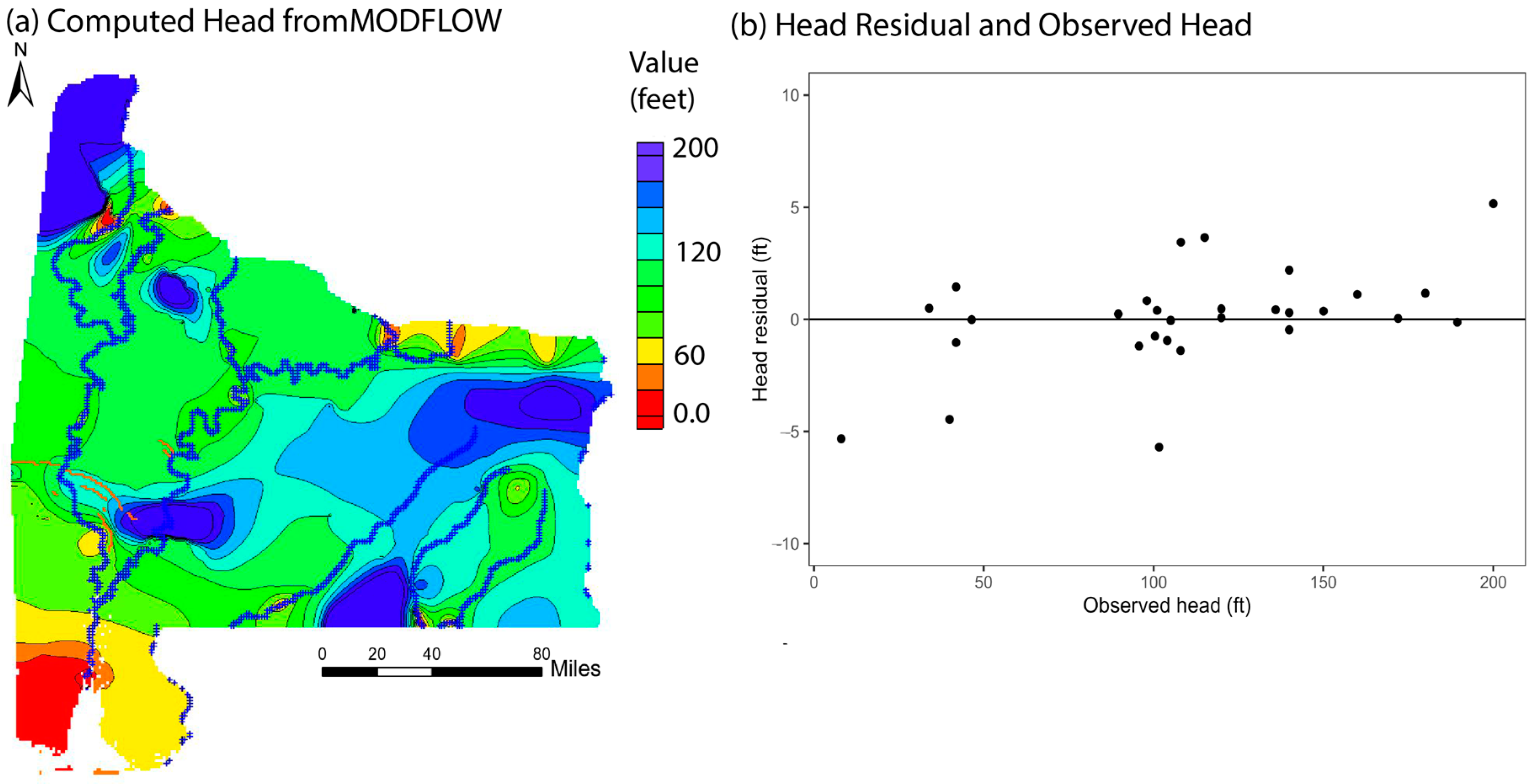
3.1. Steady-State Groundwater Flow Model
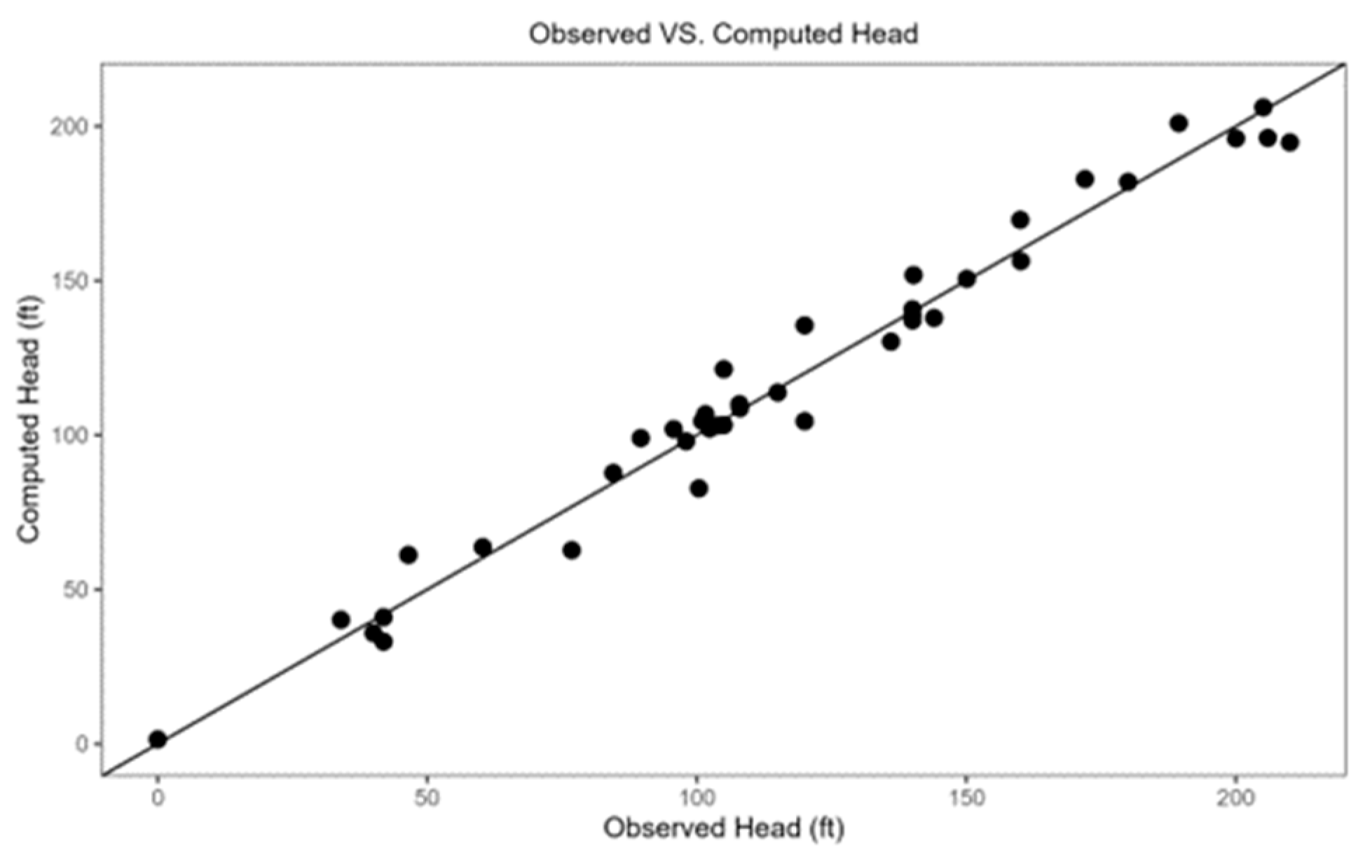
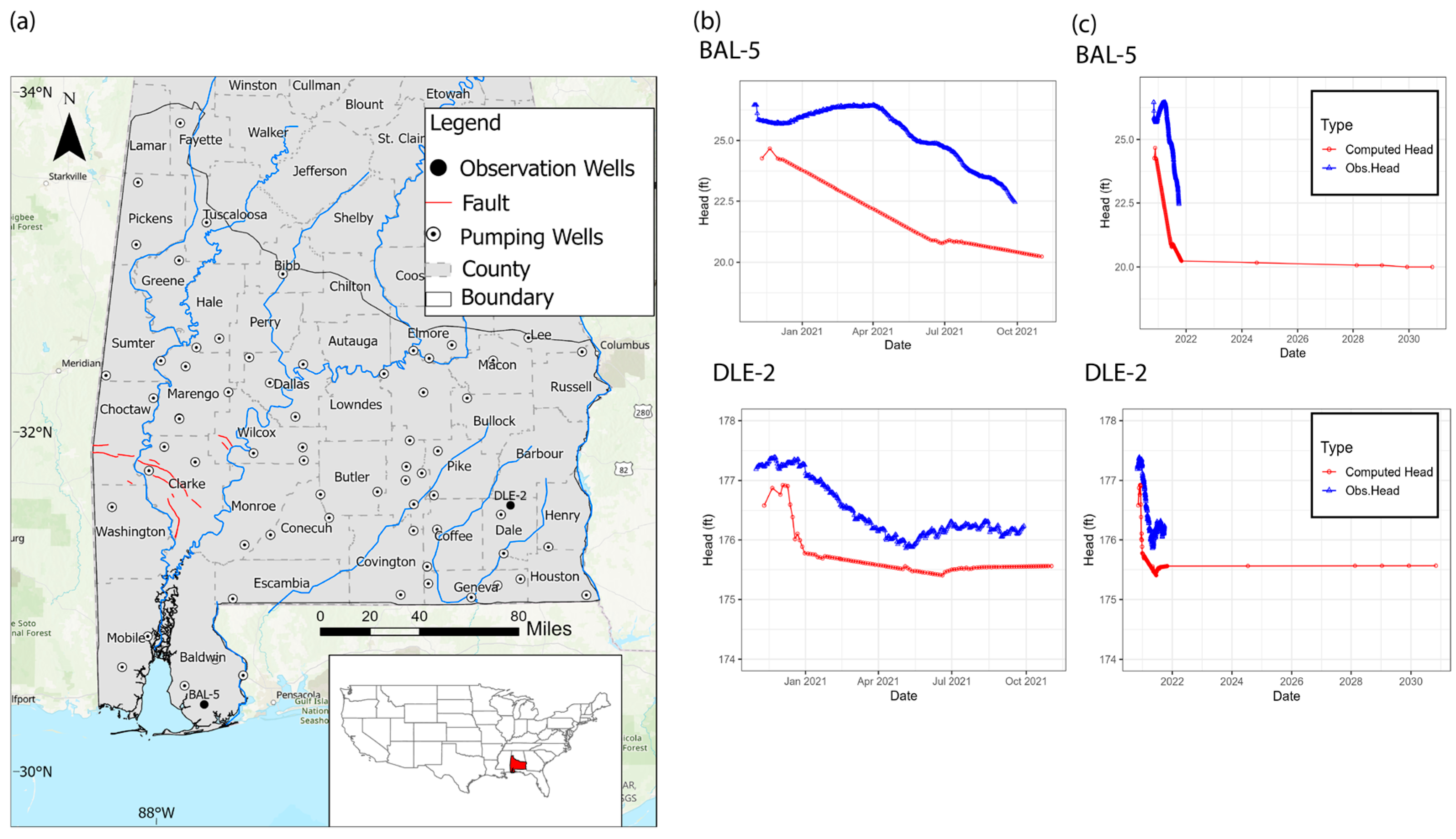
3.1.1. Model Calibration
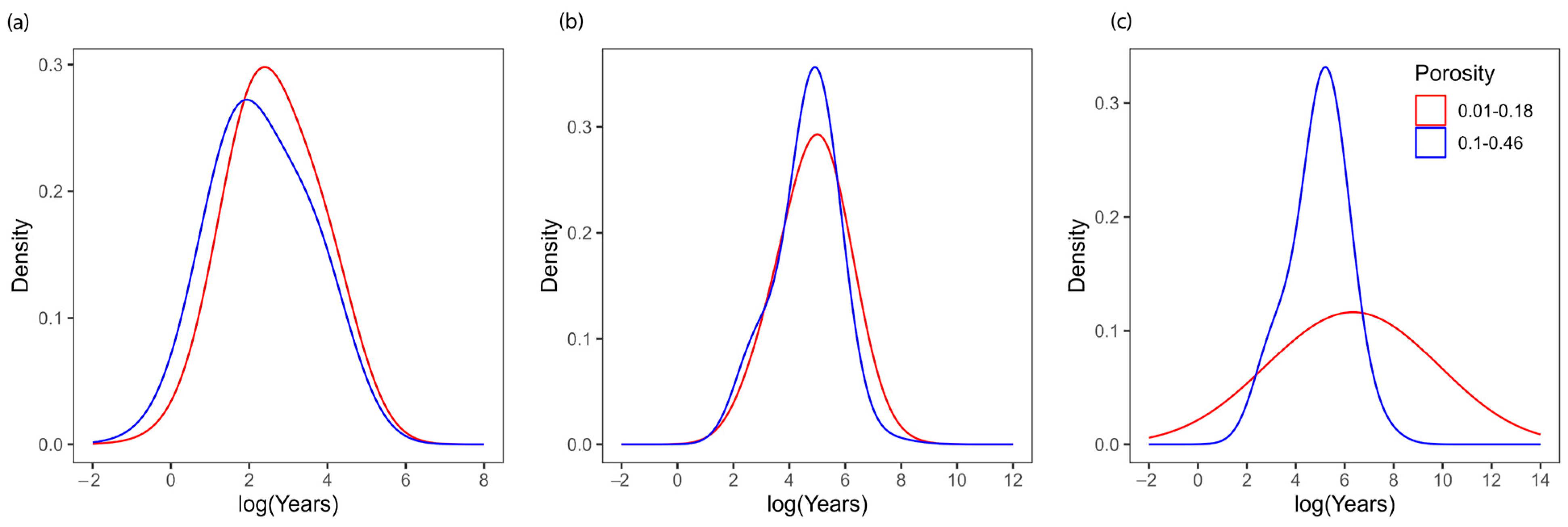
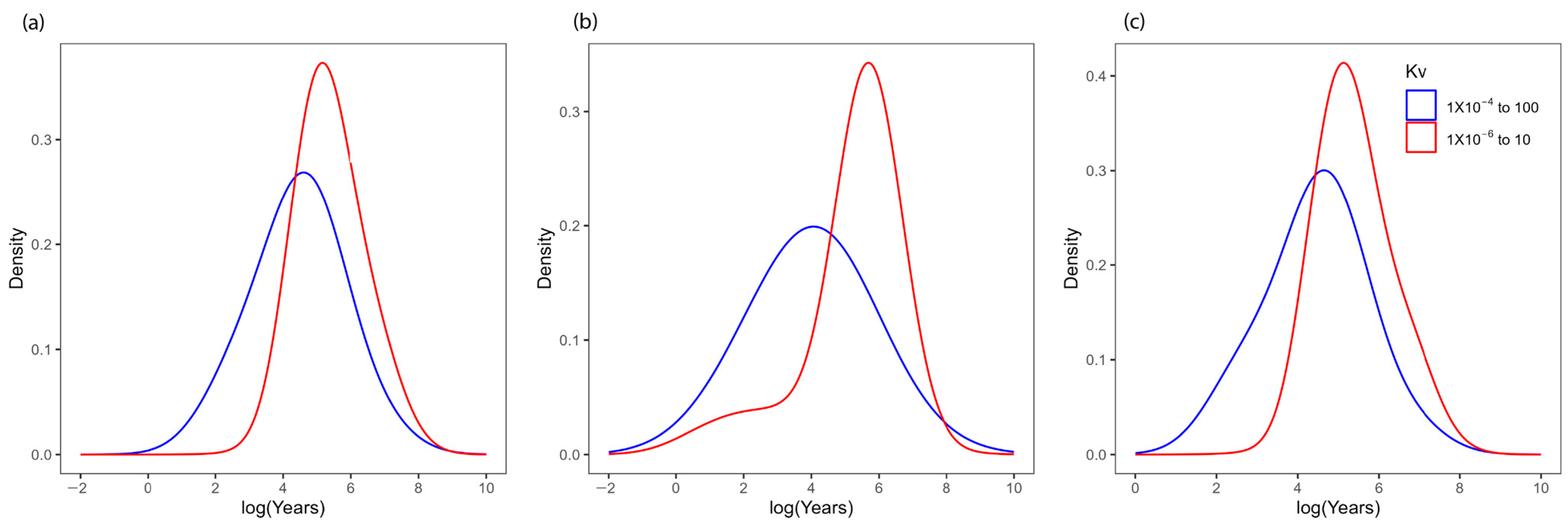
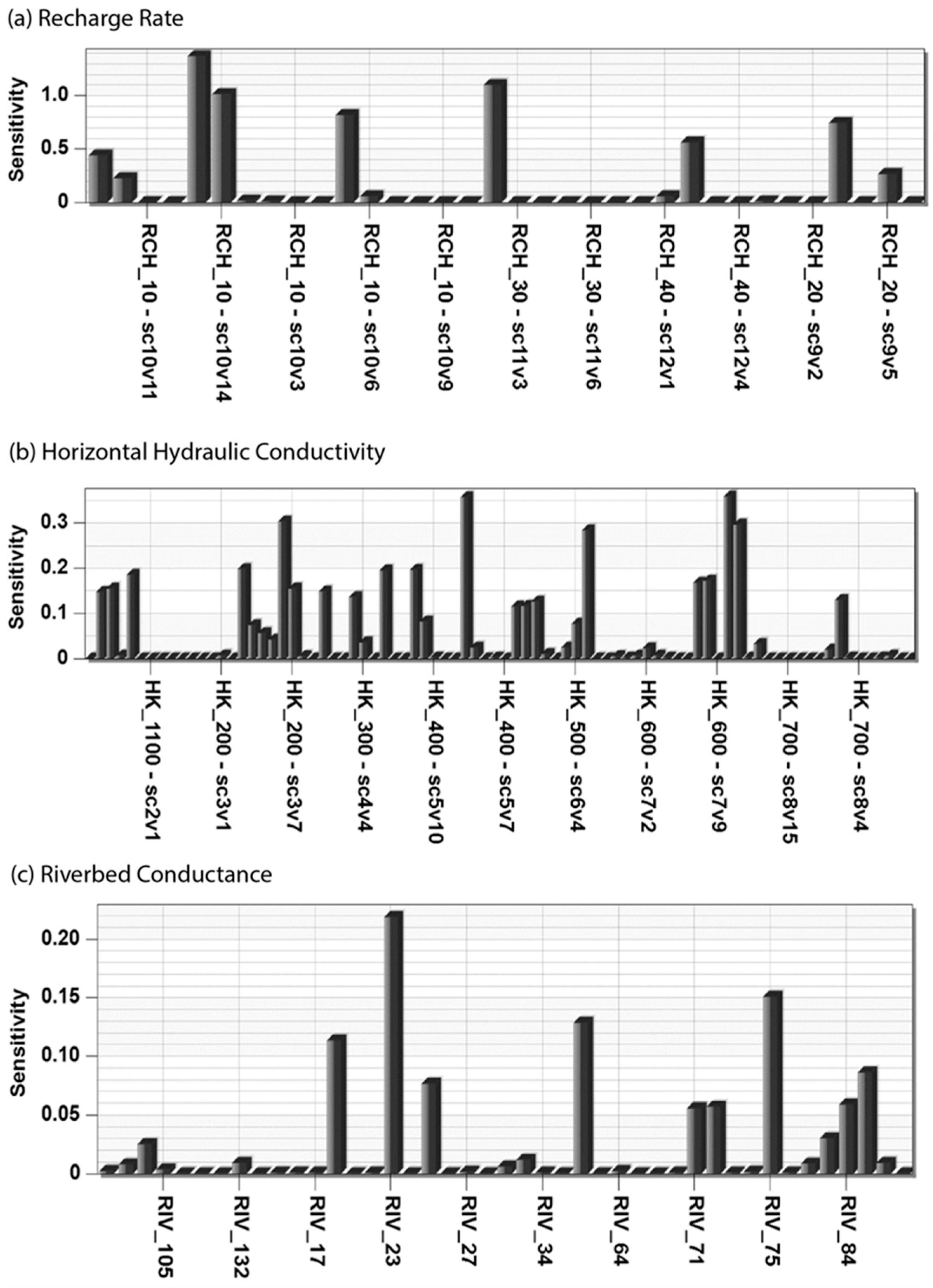
3.1.2. Parameter Sensitive Analysis
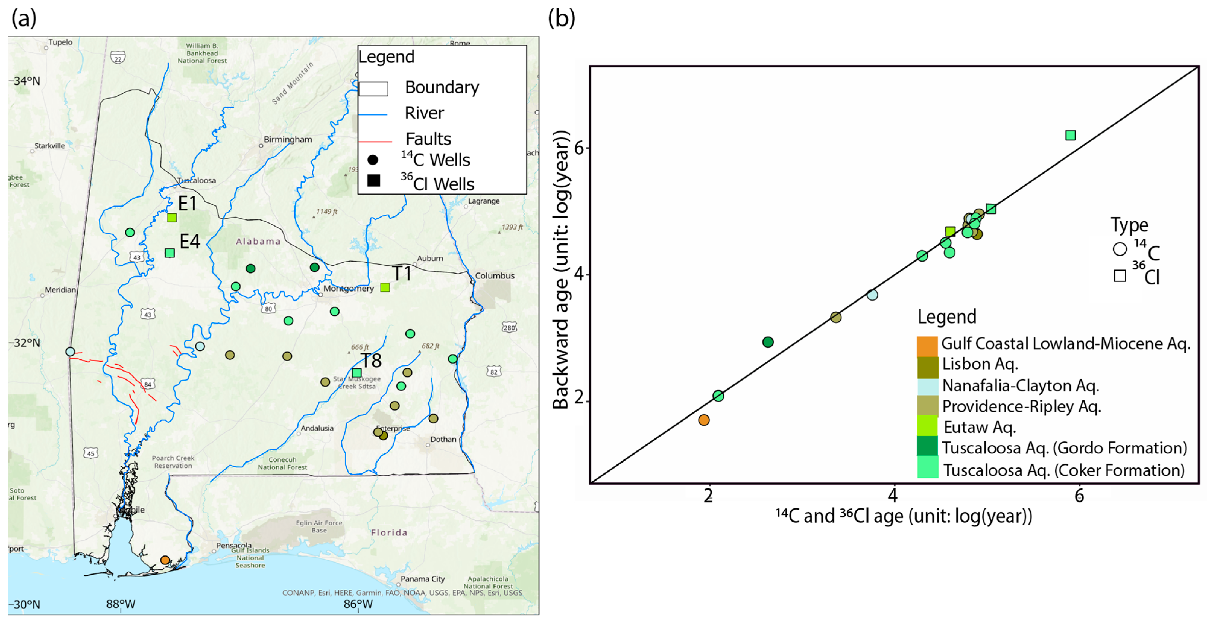
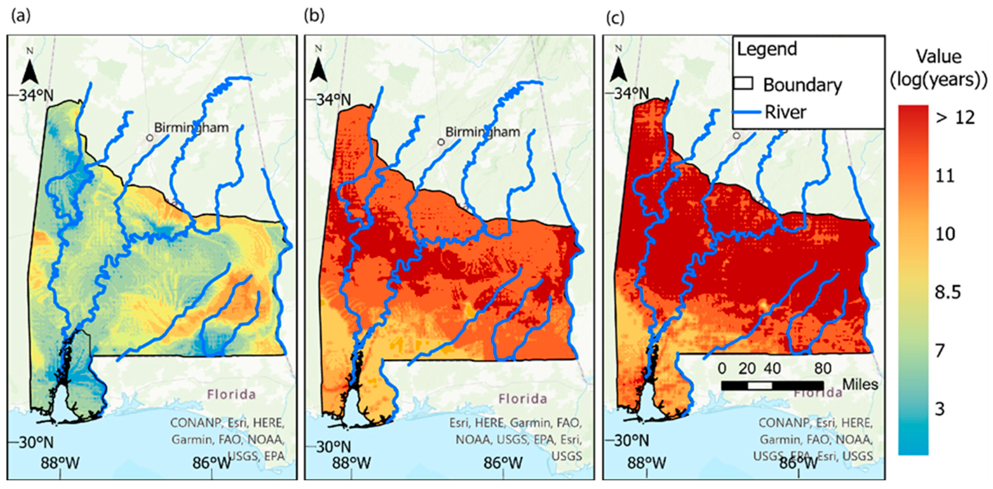
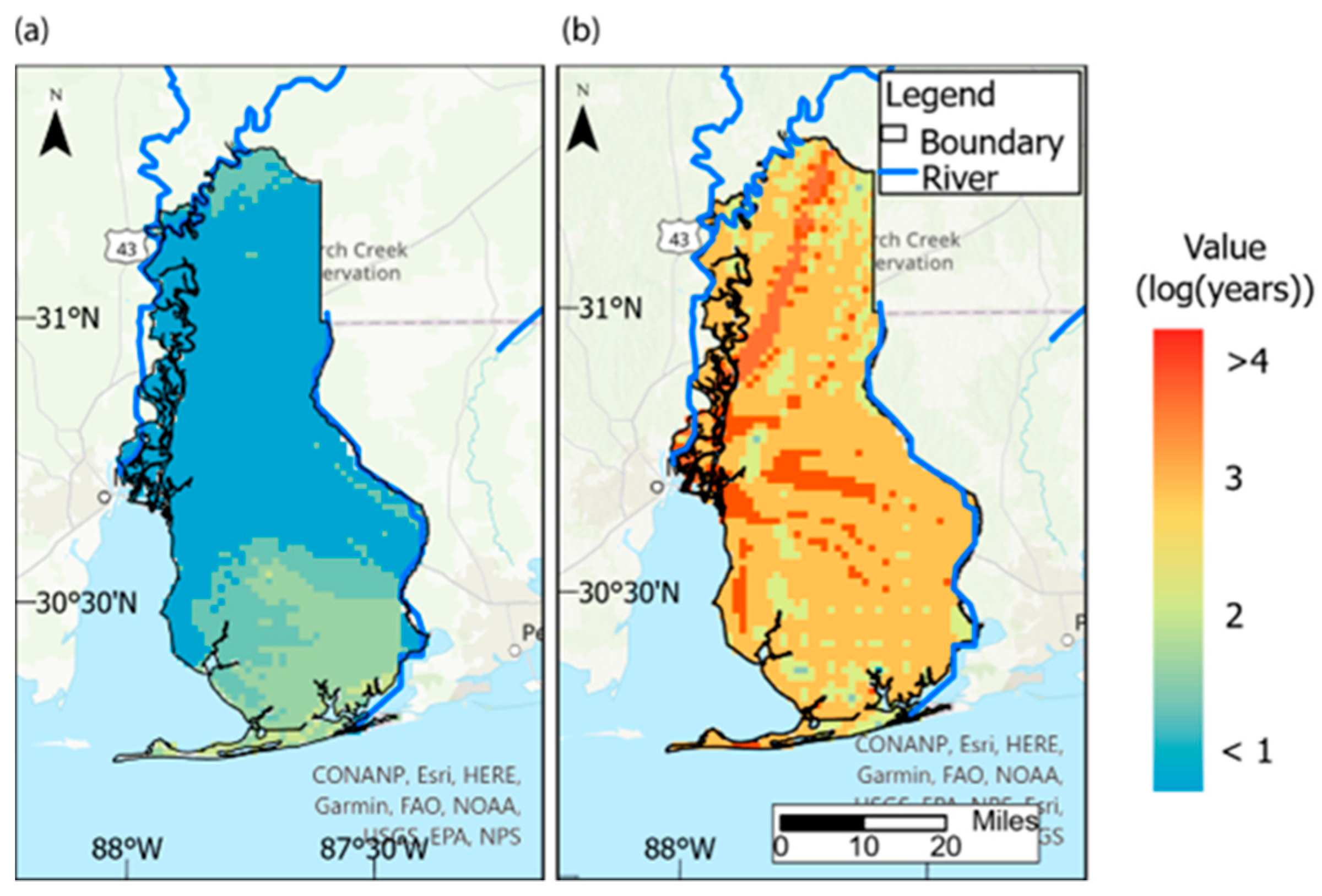
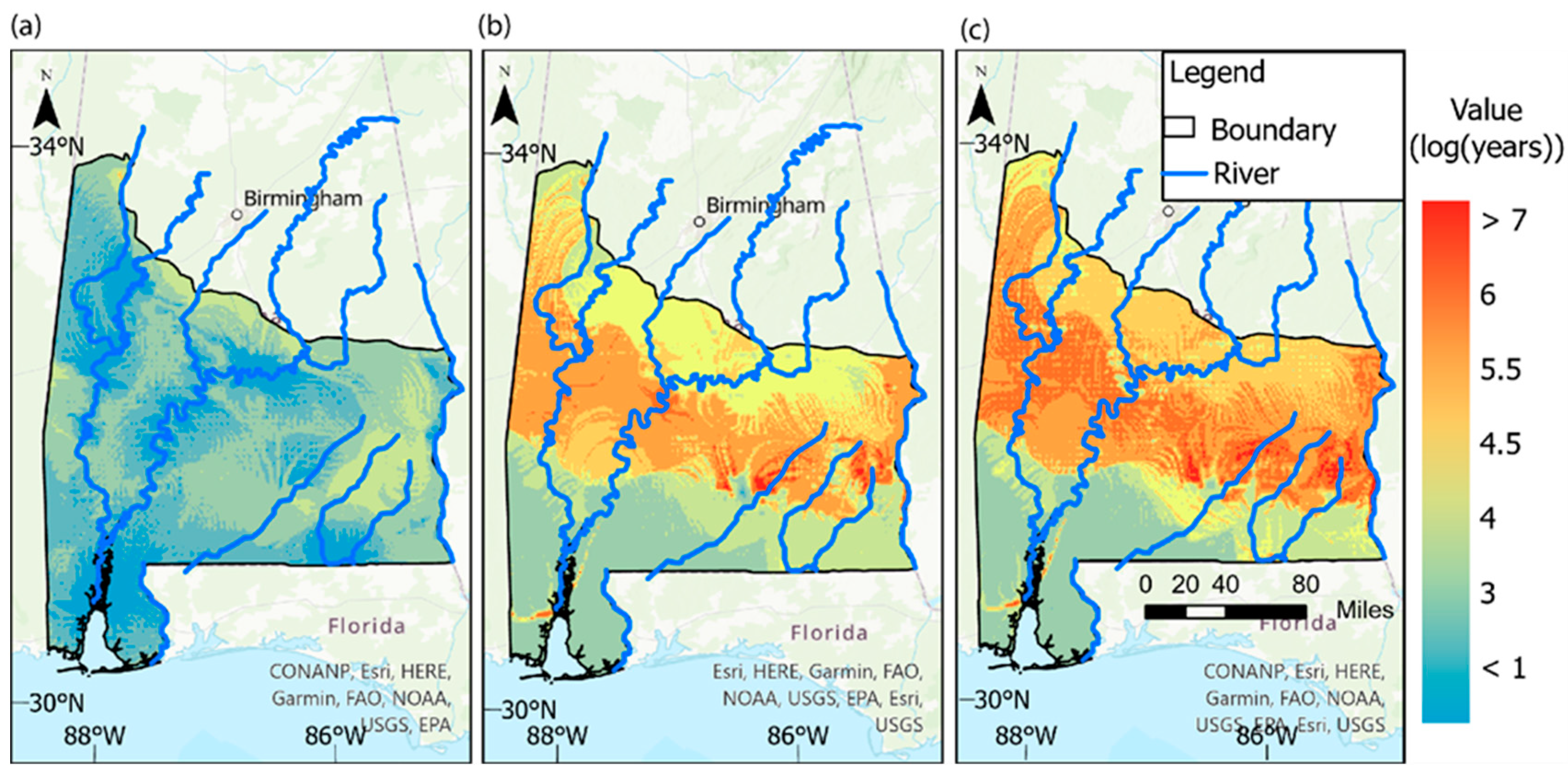
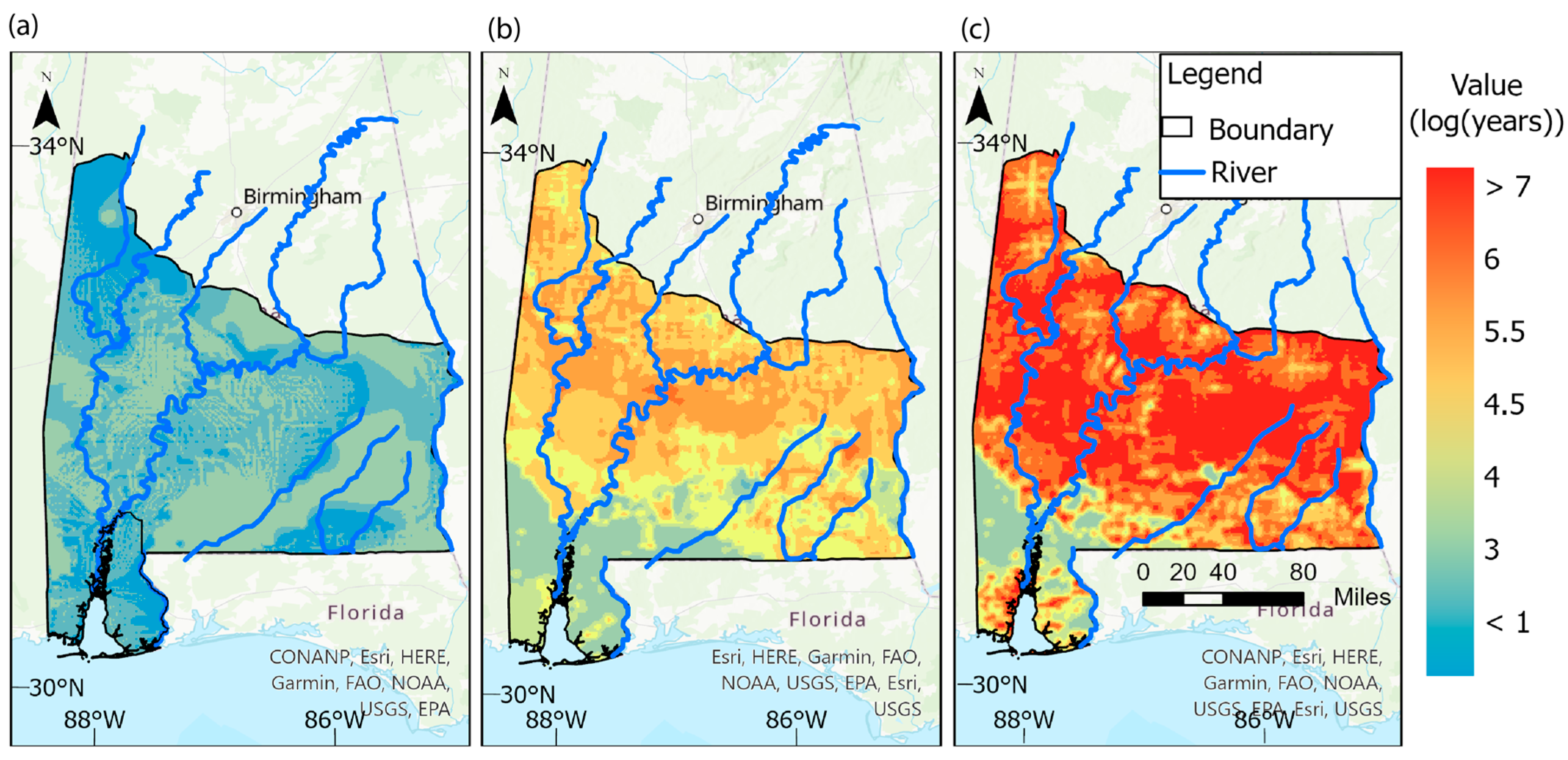
3.2. Groundwater Age and Residence Time
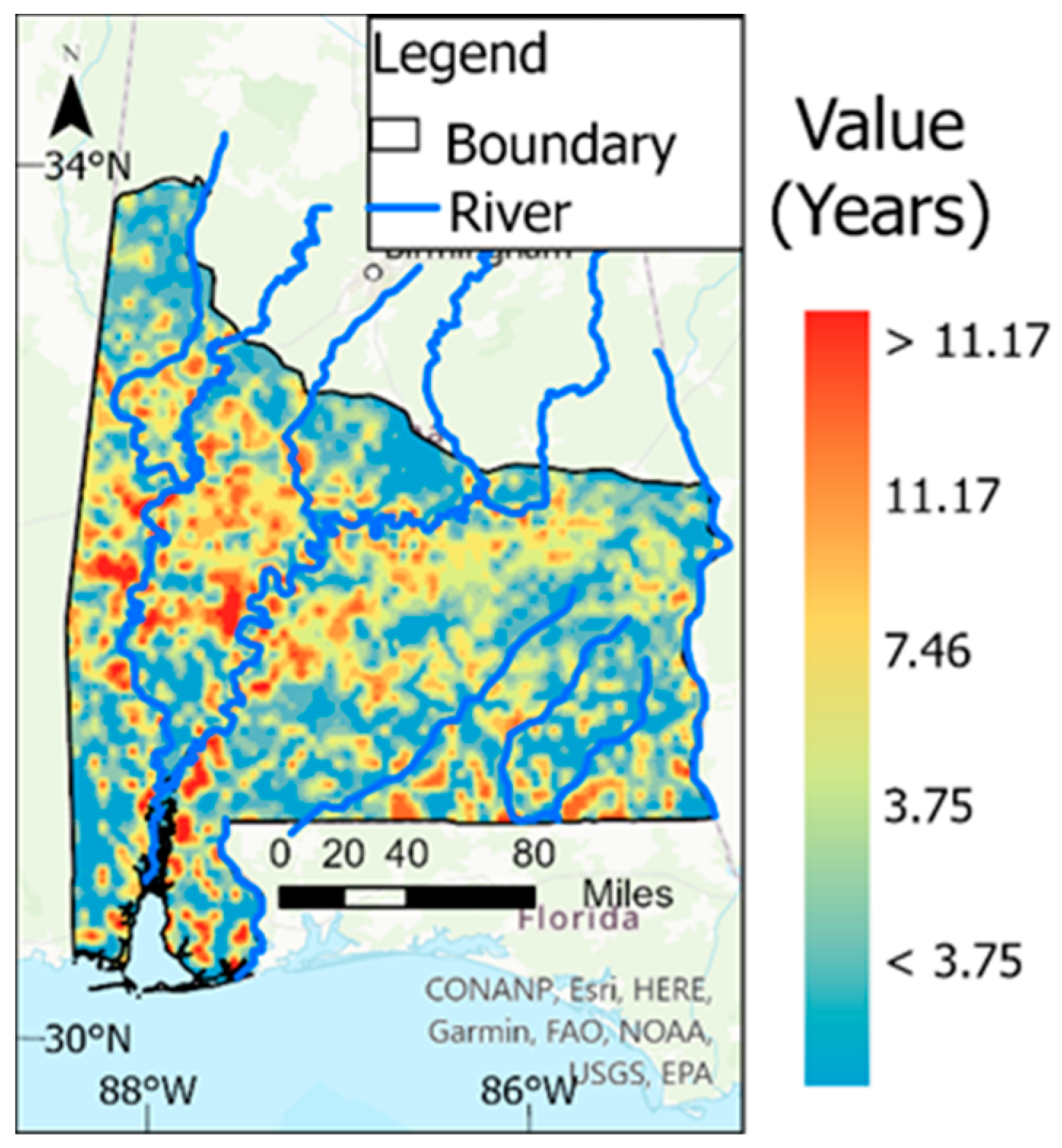
3.2.1. Backward Particle Tracking to Calculate Groundwater Age
3.2.2. Forward Particle Tracking Calculates Residence Time
3.2.3. Total Travel Time
4. Discussion
4.1. Vulnerability of Southern Alabama Aquifers with Broad Groundwater Ages
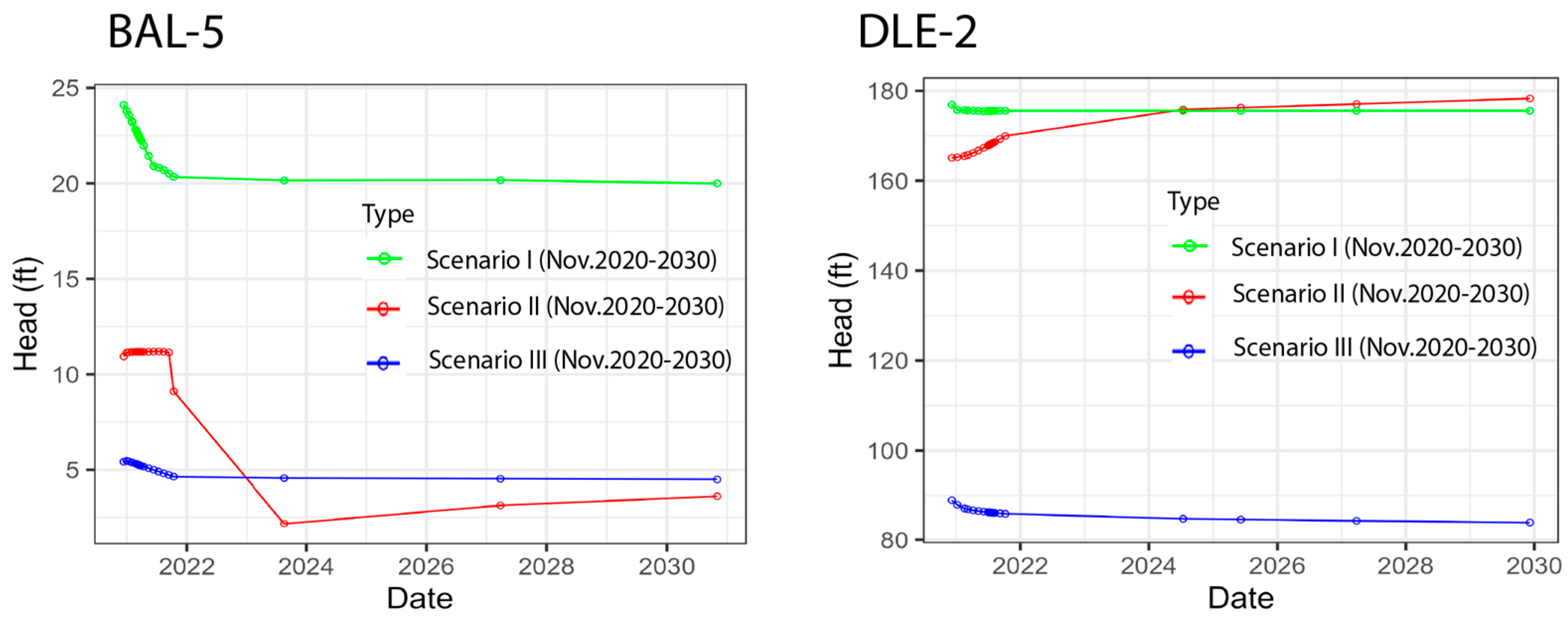
4.2. Extension to Transient Flow: Impact on GWV
5. Conclusions
Author Contributions
Funding
Data Availability Statement
Acknowledgments
Conflicts of Interest
Appendix A. Local Scale Result

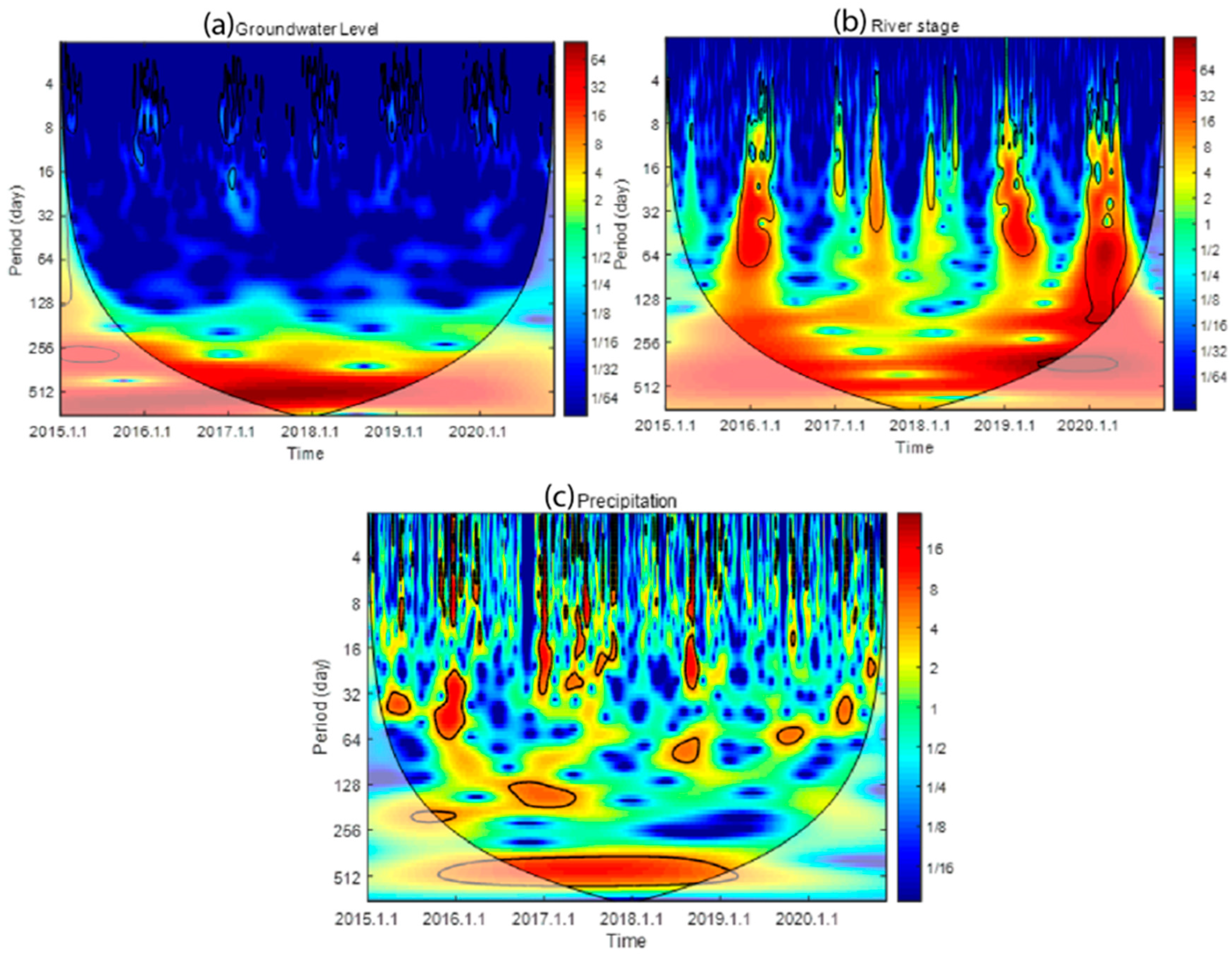
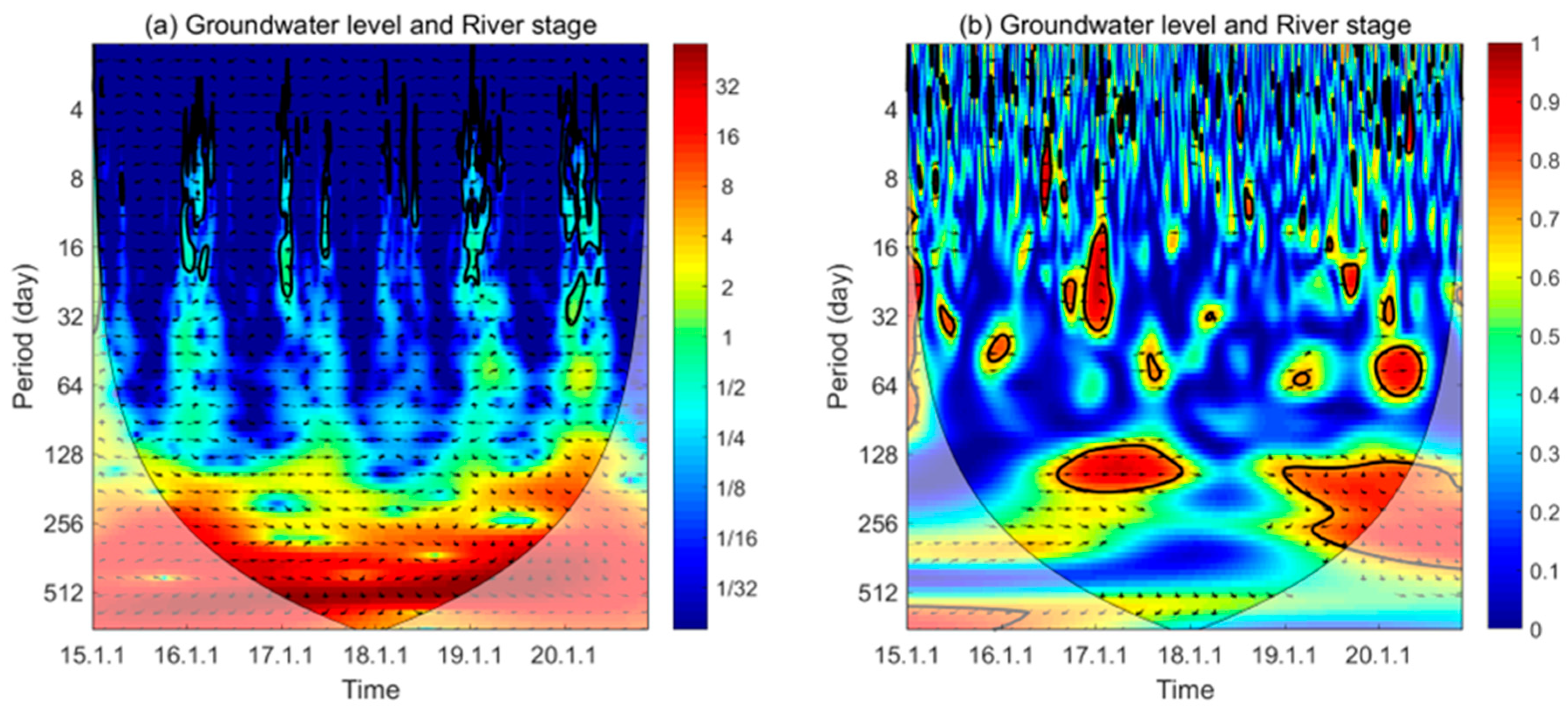
Appendix B. Wavelet Analysis

| Scale | <30 Days | 30–90 Days | 90–180 Days | 180–365 Days | >365 Days | All Scales |
|---|---|---|---|---|---|---|
| AWC | 0.3029 | 0.3103 | 0.3396 | 0.5342 | 0.4411 | 0.3553 |
| PASC | 5.9489 | 7.9546 | 15.5922 | 23.6072 | 7.3281 | 10.2025 |
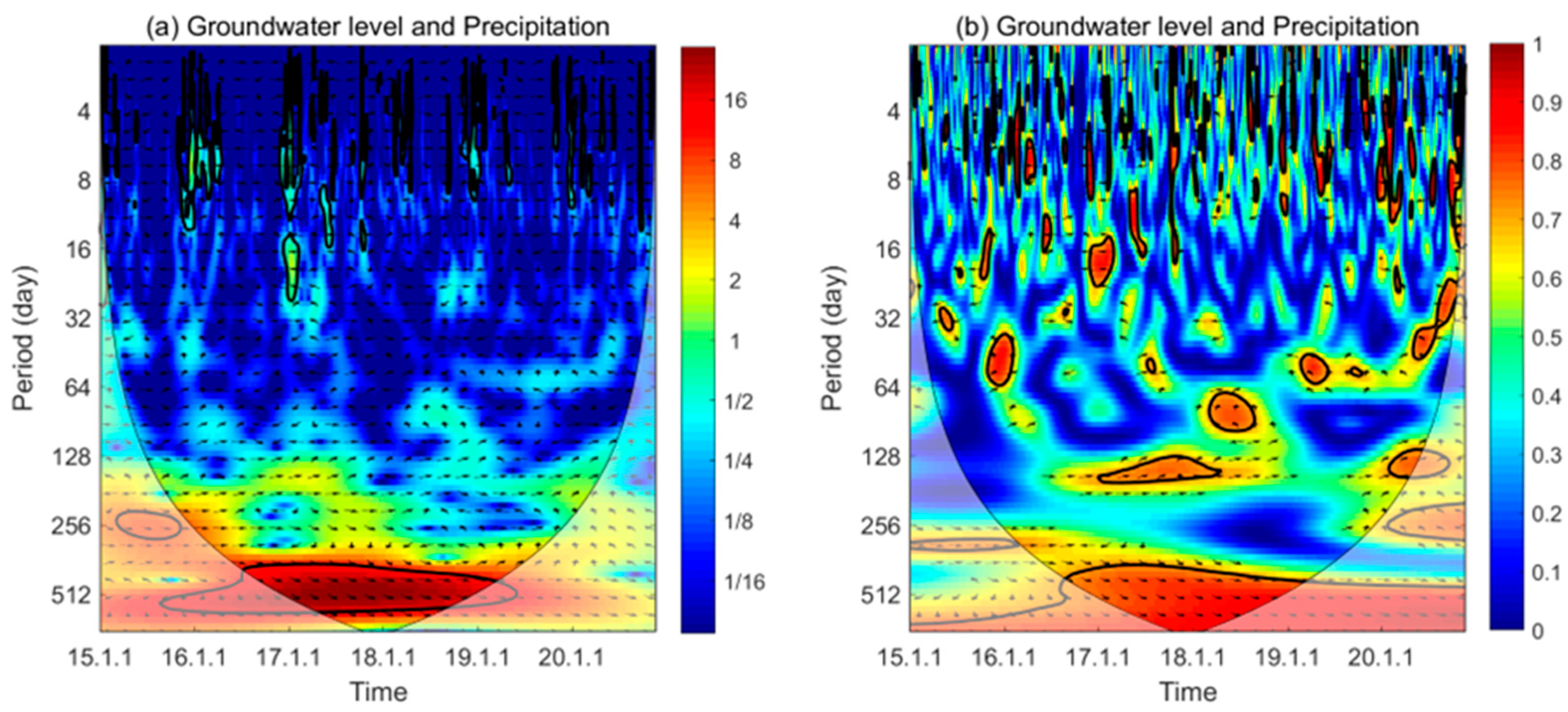
| Scale | <30 Days | 30–90 Days | 90–180 Days | 180–365 Days | >365 Days | All Scales |
|---|---|---|---|---|---|---|
| AWC | 0.3441 | 0.3346 | 0.3753 | 0.4264 | 0.7583 | 0.4066 |
| PASC | 9.1637 | 5.8054 | 9.2687 | 8.6847 | 68.5414 | 15.5819 |
Appendix C. Vadose Zone Age and Model Parameter Table

| Name | Explanation | Parameters | Unit | Original Range | Calibrated Distribution |
|---|---|---|---|---|---|
| Horizontal Hydraulic Conductivity | Gulf coastal lowland aquifer | HK_100—sc1v1 to HK_100—sc1v6 | ft/day | 1~42,000 | 1~35,643 |
| Lisbon aquifer | HK_200—sc3v1 to HK_200—sc3v11 | 0.00833~1000 | 0.0789~1000 | ||
| Nanafalia-Clayton aquifer | HK_300—sc4v1 to HK_300—sc4v7 | 0.01~5000 | 0.0316~5000 | ||
| Providence-Ripley aquifer | HK_400—sc5v1 to HK_400—sc5v9 | 0.0567~5000 | 0.0567~4546 | ||
| Eutaw aquifer | HK_500—sc6v1 to HK_500—sc6v8 | 0.0255~42,000 | 0.0365~28,293 | ||
| Gordo aquifer | HK_600—sc7v1 to HK_600—sc7v5 | 0.0255~42,000 | 0.0255~22,481 | ||
| Coker aquifer | HK_700—sc8v1 to HK_700—sc8v18 | 0.0255~42,000 | 0.0255~219 | ||
| Clay | HK_1100—sc2v1 to HK_1100—sc2v5 | 1 × 10⁻⁶~1 | 0.000105~0.198 | ||
| Recharge rate | Zone 1 | RCH_10—sc10v1 to RCH_10—sc10v8 | ft/day | 1 × 10⁻⁸~1 | 1.3 × 10⁻⁷~0.0338 |
| Zone 2 | RCH_20—sc9v1 to RCH_20—sc9v8 | 1 × 10⁻⁸~5 | 6.9 × 10⁻⁷~0.0280 | ||
| Zone 3 | RCH_30—sc11v1 to RCH_30—sc11v8 | 1 × 10⁻⁸~6 | 8.8 × 10⁻⁶~0.0210 | ||
| Zone 4 | RCH_40—sc12v1 to RCH_40—sc12v5 | 1 × 10⁻⁸~7 | 3.9 × 10⁻⁸~0.0182 | ||
| Riverbed Conductance | Tombigbee River | RIV_11 to RIV_18 | ft2/day | 0.0001~100 | 0.00130~9.97 |
| Alabama River | RIV_21 to RIV_27 | 0.0001~100 | 0.00453~64.87 | ||
| Cahaba River | RIV_31 to RIV_34 | 0.0001~100 | 0.0289~44.46 | ||
| Conecuh River | RIV_61 to RIV_67 | 0.0001~100 | 0.0582~3.09 | ||
| Pea River | RIV_71 to RIV_75 | 0.0001~100 | 0.0217~8.74 | ||
| Choctawhatchee River | RIV_81 to RIV_84 | 0.0001~100 | 0.113~0.14 | ||
| Sipsey River | RIV_91 to RIV_93 | 0.0001~100 | 0.00760~4.17 |
References
- Chitsazan, M.; Akhtari, Y. A GIS-based DRASTIC model for assessing aquifer vulnerability in Kherran Plain, Khuzestan, Iran. Water Resour. Manag. 2009, 23, 1137–1155. [Google Scholar] [CrossRef]
- El-Naqa, A.; Al-Shayeb, A. Groundwater protection and management strategy in Jordan. Water Resour. Manag. 2009, 23, 2379–2394. [Google Scholar] [CrossRef]
- Wu, W.; Yin, S.; Liu, H.; Chen, H. Groundwater vulnerability assessment and feasibility mapping under reclaimed water irrigation by a modified DRASTIC model. Water Resour. Manag. 2014, 28, 1219–1234. [Google Scholar] [CrossRef]
- Sadeghfam, S.; Hassanzadeh, Y.; Nadiri, A.A.; Zarghami, M. Localization of groundwater vulnerability assessment using catastrophe theory. Water Resour. Manag. 2016, 30, 4585–4601. [Google Scholar] [CrossRef]
- Momejian, N.; Abou Najm, M.; Alameddine, I.; El-Fadel, M. Groundwater vulnerability modeling to assess seawater intrusion: A methodological comparison with geospatial interpolation. Water Resour. Manag. 2019, 33, 1039–1052. [Google Scholar] [CrossRef]
- Ahuja, S. Water quality worldwide. In Handbook of Water Purity and Quality; Academic Press: Cambridge, MA, USA, 2021; pp. 19–33. [Google Scholar]
- Foster, S.S.D.; Chilton, P.J. Groundwater: The processes and global significance of aquifer degradation. Philos. Trans. R. Soc. London. Ser. B Biol. Sci. 2003, 358, 1957–1972. [Google Scholar] [CrossRef] [PubMed]
- Fannakh, A.; Farsang, A. DRASTIC, GOD, and SI approaches for assessing groundwater vulnerability to pollution: A review. Environ. Sci. Europe 2022, 34, 77. [Google Scholar] [CrossRef]
- Taghavi, N.; Niven, R.K.; Paull, D.J.; Kramer, M. Groundwater vulnerability assessment: A review including new statistical and hybrid methods. Sci. Total Environ. 2022, 822, 153486. [Google Scholar] [CrossRef]
- Machiwal, D.; Jha, M.K.; Singh, V.P.; Mohan, C. Assessment and mapping of groundwater vulnerability to pollution: Current status and challenges. Earth-Sci. Rev. 2018, 185, 901–927. [Google Scholar] [CrossRef]
- Zhang, Y.; Weissmann, G.S.; Fogg, G.E.; Lu, B.; Sun, H.G.; Zheng, C.M. Assessment of groundwater susceptibility to non-point source contaminants using three-dimensional transient indexes. Int. J. Environ. Res. Public Health 2018, 15, 1177. [Google Scholar] [CrossRef]
- Lindström, R. Groundwater Vulnerability Assessment Using Process-Based Models. Ph.D. Thesis, KTH Royal Institute of Technology, Stockholm, Sweden, 2005. [Google Scholar]
- Goyal, D.; Haritash, A.K.; Singh, S.K. A comprehensive review of groundwater vulnerability assessment using index-based, modelling, and coupling methods. J. Environ. Manag. 2021, 296, 113161. [Google Scholar] [CrossRef] [PubMed]
- Connell, L.D.; Van den Daele, G. A quantitative approach to aquifer vulnerability mapping. J. Hydrol. 2003, 276, 71–88. [Google Scholar] [CrossRef]
- Voss, C.I. A finite element simulation model for saturated-unsaturated fluid density-dependent groundwater flow with energy transport or chemically reactive single-species solute transport. In Water Resource Investigations Report 84-4369; United States Geological Survey: Reston, VA, USA, 1984. [Google Scholar]
- Kalhor, K.; Ghasemizadeh, R.; Rajic, L.; Alshawabkeh, A. Assessment of groundwater quality and remediation in karst aquifers: A review. Groundw. Sustain. Dev. 2019, 8, 104–121. [Google Scholar] [CrossRef] [PubMed]
- Zhao, X.; Wang, D.; Xu, H.; Ding, Z.; Shi, Y.; Lu, Z.; Cheng, Z. Groundwater pollution risk assessment based on groundwater vulnerability and pollution load on an isolated island. Chemosphere 2022, 289, 133134. [Google Scholar] [CrossRef]
- Styczen, M.; Storm, B. Modelling of N-movements on catchment scale—A tool for analysis and decision making. 1. model description. 2. a case study. Fertil. Res. 1993, 36, 1–6. [Google Scholar] [CrossRef]
- Kassem, A.H.; Doummar, J.; Gurdak, J.J. Sensitivity of an integrated groundwater flow model to model parameters—Application to vulnerability assessment of karst aquifers. Groundw. Sustain. Dev. 2022, 17, 100737. [Google Scholar] [CrossRef]
- Šejna, M.; Šimůnek, J.; van Genuchten, M.T. The HYDRUS Software Package for Simulating Two- and Three-Dimensional Movement of Water, Heat, and Multiple Solutes in Variably-Saturated Media, Version 3.01; User Manual; PC-Progress: Prague, Czech Republic, 2018; p. 322. [Google Scholar]
- Miao, J.; Ma, Z.; Liu, H.; Guo, X.; Bai, Y.; Lan, T.; Wang, F.; Cao, Y. Evaluation of the vulnerability of a leaky aquifer considering the retardation effect of an aquitard for specific pollutants: Case study in the Tongzhou Plain, China. Hydrogeol. J. 2020, 28, 687–701. [Google Scholar] [CrossRef]
- Sonnenborg, T.O.; Scharling, P.B.; Hinsby, K.; Rasmussen, E.S.; Engesgaard, P. Aquifer vulnerability assessment based on sequence stratigraphic and 39Ar transport modeling. Groundwater 2016, 54, 214–230. [Google Scholar] [CrossRef]
- Medici, G.; Engdahl, N.B.; Langman, J.B. A basin-scale groundwater flow model of the Columbia Plateau regional aquifer system in the Palouse (USA): Insights for aquifer vulnerability assessment. Int. J. Environ. Res. 2021, 15, 299–312. [Google Scholar] [CrossRef]
- Snyder, D.T.; Wilkinson, J.M.; Orzol, L.L. Use of a Ground-Water Flow Model with Particle Tracking to Evaluate Ground-Water Vulnerability; US Geological Survey: Washington, DC, USA, 1999.
- Molson, J.W.; Frind, E.O. On the use of mean groundwater age, life expectancy and capture probability for defining aquifer vulnerability and time-of-travel zones for source water protection. J. Contam. Hydrol. 2012, 127, 76–87. [Google Scholar] [CrossRef]
- Klaas, D.K.; Imteaz, M.A.; Arulrajah, A. Development of groundwater vulnerability zones in a data-scarce eogenetic karst area using Head-Guided Zonation and particle-tracking simulation methods. Water Res. 2017, 122, 17–26. [Google Scholar] [CrossRef] [PubMed]
- Ponprasit, C.; Zhang, Y.; Wei, W. Backward location and travel time probabilities for pollutants moving in three-dimensional aquifers: Governing equations and scale effect. Water 2022, 14, 624. [Google Scholar] [CrossRef]
- Pryet, A.; Matran, P.; Cousquer, Y.; Roubinet, D. Particle tracking as a vulnerability assessment tool for drinking water production. Front. Earth Sci. 2022, 10, 975156. [Google Scholar] [CrossRef]
- Šrajbek, M.; Kranjčević, L.; Kovač, I.; Biondić, R. Groundwater nitrate pollution sources assessment for contaminated wellfield. Water 2022, 14, 255. [Google Scholar] [CrossRef]
- Martinelli, G.; Cervi, F.; Dadomo, A.; Medioli, G. A preliminary assessment of young water fractions in groundwater from alluvial aquifers facing the northern Italian Apennines. Water 2022, 14, 659. [Google Scholar] [CrossRef]
- Soriano, M.A., Jr.; Deziel, N.C.; Saiers, J.E. Regional scale assessment of shallow groundwater vulnerability to contamination from unconventional hydrocarbon extraction. Environ. Sci. Technol. 2022, 56, 12126–12136. [Google Scholar] [CrossRef]
- Maxwell, R.M.; Condon, L.E.; Kollet, S.J. A high-resolution simulation of groundwater and surface water over most of the continental US with the integrated hydrologic model ParFlow v3. Geosci. Model Dev. 2015, 8, 923–937. [Google Scholar] [CrossRef]
- Toth, J. A theoretical analysis of groundwater flow in small drainage basins. J. Geophys. Res. 1963, 68, 4795–4812. [Google Scholar] [CrossRef]
- Chen, Z.; Nie, Z.; Zhang, Z.; Qi, J.; Nan, Y. Isotopes and sustainability of groundwater resources, North China Plain. Groundwater 2005, 43, 485–493. [Google Scholar] [CrossRef]
- Hinsby, K.; Rasmussen, E.S. The Miocene Sand Aquifers, Jutland, Denmark. In Natural Groundwater Quality; Edmunds, W.M., Shand, P., Eds.; Blackwell Publishing Ltd.: Oxford, UK, 2008; p. 306. [Google Scholar]
- Harper, M.J.; Littlepage, T.M.; Johnston, D.D., Jr.; Atkins, J.B. Estimated 2015 Water Use and Surface Water Availability in Alabama, the Office of Water Resources, a Division of ADECA (Alabama Department of Economic and Community Affairs). Available online: https://adeca.alabama.gov/water-management/publications-reports-and-information (accessed on 15 December 2022).
- Cook, M.R.; Jennings, S.P.; Moss, N.E. Assessment of Aquifer Recharge, Ground-Water Production Impacts, and Future Ground-Water Development in Southeast Alabama; Geological Survey of Alabama: Tuscaloosa, AL, USA, 2007. [Google Scholar]
- Hairston, J.E.; Rodekohr, D.; Brantley, E.; Kensler, M. Water Resources in Alabama. 2008. Available online: http://www.encyclopediaofalabama.org/article/h-1645 (accessed on 15 December 2022).
- Gleeson, T.; VanderSteen, J.; Sophocleous, M.A.; Taniguchi, M.; Alley, W.M.; Allen, D.M.; Zhou, Y. Groundwater sustainability strategies. Nat. Geosci. 2010, 3, 378–379. [Google Scholar] [CrossRef]
- Davis, M.E. Stratigraphic and Hydrogeologic Framework of the Alabama Coastal Plain; U.S. Geological Survey Water-Resources Investigations Report 87-4112; United States Department of the Interior, Geological Survey: Reston, VA, USA, 1987.
- Slack, L.J.; Planert, M. Alabama Ground-Water Quality; US Geological Survey Open-File Report; United States Department of the Interior, Geological Survey: Reston, VA, USA, 1987; p. 0711.
- Murgulet, D.; Tick, G.R. The extent of saltwater intrusion in southern Baldwin County, Alabama. Environ. Geol. 2008, 55, 1235–1245. [Google Scholar] [CrossRef]
- Murgulet, D.; Tick, G.R. Assessing the extent and sources of nitrate contamination in the aquifer system of southern Baldwin County, Alabama. Environ. Geol. 2009, 58, 1051–1065. [Google Scholar] [CrossRef]
- Gillett, B.; Raymond, D.E.; Moore, J.D.; Tew, B.H. Hydrogeology and vulnerability to contamination of major aquifers in Alabama: Area 13. Geol. Surv. Ala. Circ. A 2000, 199, 68. [Google Scholar]
- Guthrie, M.G.; Puckett, M.P.; Hastert, G. A Shallow Aquifer Recharge Potential Model for Alabama; Geological Survey of Alabama: Tuscaloosa, AL, USA, 2022. [Google Scholar]
- Harbaugh, A.W. MODFLOW-2005, the US Geological Survey Modular Ground-Water Model: The Ground-Water Flow Process; US Department of the Interior, US Geological Survey: Reston, VA, USA, 2005.
- Pollock, D.W. User’s Guide for MODPATH/MODPATH-PLOT, Version 3: A Particle Tracking Post-Processing Package for MODFLOW the U.S. Geological Survey Finite-Difference Ground-Water Flow Model; Open-File Report 94-464, United States Geological Survey: Reston, VA, USA, 1994. [Google Scholar]
- Geological Survey of Alabama (GSA). Assessment of Groundwater Resources in Alabama, 2010–2016. Geol. Surv. Ala. Bull. 2018, 186, 426. [Google Scholar]
- Szabo, M.W.; Osborne, W.E.; Copeland, C.W.; Neathery, T.L., Jr. Geologic Map of Alabama (1:250,000); Alabama Geological Survey Special Map 220; Geological Survey of Alabama, Stratigraphy and Paleontology Division: Tuscaloosa, AL, USA, 1998. [Google Scholar]
- Raymond, D.E. Alabama Stratigraphy (No. 140); Geological Survey of Alabama, Stratigraphy and Paleontology Division: Tuscaloosa, AL, USA, 1988. [Google Scholar]
- Cook, M.R. The Eutaw Aquifer in Alabama; No. 156; Geological Survey of Alabama, Hydrogeology Division: Tuscaloosa, AL, USA, 1993. [Google Scholar]
- Williams, J.S.; Planert, M.; DeJarnette, S.S. Potentiometric Surface, Ground-Water Withdrawals, and Recharge Area for the Providence-Ripley Aquifer in Alabama, Fall 1982; United States Geological Survey: Reston, VA, USA, 1986.
- Osborne, E.W.; Szabo, M.W.; Copeland, C.W.; Neathery, T.L. Geologic Map of Alabama; Scale 1: 250,000; Alabama Geological Survey: Tuscaloosa, AL, USA, 1989. [Google Scholar]
- Toulmin, L.D.; LaMoreaux, P.E. Stratigraphy Along Chattahoochee River, Connecting Link Between Atlantic and the Gulf Coastal Plains. AAPG Bull. 1963, 47, 385–404. [Google Scholar] [CrossRef]
- Clark, B.R.; Hart, R.M. The Mississippi Embayment Regional Aquifer Study (MERAS): Documentation of a Groundwater-Flow Model Constructed to Assess Water Availability in the Mississippi Embayment. 2009. Available online: https://pubs.usgs.gov/sir/2009/5172/ (accessed on 15 December 2022).
- Domenico, P.A.; Schwartz, F.W. Physical and Chemical Hydrogeology; John Wiley & Sons: Hoboken, NJ, USA, 1997. [Google Scholar]
- Faye, R.E.; Smith, W.G. Relations of Borehole Resistivity to the Horizontal Hydraulic Conductivity and Dissolved-Soils Concentration in Water of Clastic Coastal Plain Aquifers in the Southeastern United States (No. 2414); United States Government Publishing Office: Washington, DC, USA, 1994.
- Martin, A.; Whiteman, C.D. Geohydrology and Regional Ground-Water Flow of the Coastal Lowlands Aquifer System in Parts of Louisiana, Mississippi, Alabama, and Florida—A Preliminary Analysis; United States Department of the Interior, Geological Survey: Reston, VA, USA, 1989; Volume 88.
- Sun, R.J.; Johnston, R.H. Regional Aquifer-System Analysis Program of the US Geological Survey, 1978–1992; United States Government Publishing Office: Washington, DC, USA, 1994; Volume 1099. [Google Scholar]
- Mallory, M.J. Hydrogeology of the Southeastern Coastal Plain Aquifer System in Parts of Eastern Mississippi and Western Alabama; No. 1410-G; United States Government Publishing Office: Washington, DC, USA, 1993.
- Benettin, P.; Rinaldo, A.; Botter, G. Tracking residence times in hydrological systems: Forward and backward formulations. Hydrol. Process. 2015, 29, 5203–5213. [Google Scholar] [CrossRef]
- Hill, M.C. Methods and Guidelines for Effective Model Calibration. In Building Partnerships; American Society of Civil Engineers: Minneapolis, MN, USA, 2000; pp. 1–10. [Google Scholar] [CrossRef]
- Hill, M.C.; Tiedeman, C.R. Effective Groundwater Model Calibration: With Analysis of Data, Sensitivities, Predictions, and Uncertainty; Wiley: New York, NY, USA, 2007; p. 464. [Google Scholar]
- Solder, J.E. Groundwater Age and Susceptibility of South Atlantic and Gulf Coast Principal Aquifers of the Contiguous United States; U.S. Geological Survey Scientific Investigations Report 2020–5050; United States Geological Survey: Reston, VA, USA, 2020; p. 46. [CrossRef]
- Penny, E.; Lee, M.K.; Morton, C. Groundwater and microbial processes of Alabama coastal plain aquifers. Water Resour. Res. 2003, 39, 1320. [Google Scholar] [CrossRef]
- Gardner, R.A. Model of the Ground-Water Flow System of the Gordo and Eutaw Aquifers in West-Central Alabama; Geological Survey of Alabama: Tuscaloosa, AL, USA, 1981. [Google Scholar]
- LaMoreaux, P.E.; Toulmin, L.D. Geology and Ground-Water Resources of Wilcox County, Alabama; The University of Alabama: Tuscaloosa, AL, USA, 1959. [Google Scholar]
- Newton, J.; Sutcliffe, H.; LaMoreaux, P.E. Geology and Ground-Water Resources of Marengo County, Alabama; Geological Survey of Alabama: Tuscaloosa, AL, USA, 1961. [Google Scholar]
- Jurgens, B.C.; Faulkner, K.; McMahon, P.B.; Hunt, A.G.; Casile, G.; Young, M.B.; Belitz, K. Over a third of groundwater in USA public-supply aquifers is Anthropocene-age and susceptible to surface contamination. Commun. Earth Environ. 2022, 3, 153. [Google Scholar] [CrossRef]
- Jasechko, S.; Perrone, D.; Befus, K.M.; Cardenas, B.; Ferguson, G.; Gleeson, T.; Luijendijk, E.; McDonnell, J.J.; Taylor, R.G.; Wada, Y.; et al. Global aquifers dominated by fossil groundwaters but wells vulnerable to modern contamination. Nat. Geosci. 2017, 10, 425–429. [Google Scholar] [CrossRef]
- Cornaton, F.; Perrochet, P. Groundwater age, life expectancy and transit time distributions in advective–dispersive systems; 2. Reservoir theory for sub-drainage basins. Adv. Water Resour. 2006, 29, 1292–1305. [Google Scholar] [CrossRef]
- Zhang, Y.; Brusseau, M.L.; Neupauer, R.M.; Wei, W. General backward model to identify the source for contaminants undergoing non-Fickian diffusion in water. Environ. Sci. Technol. 2022, 56, 10743–10753. [Google Scholar] [CrossRef] [PubMed]
- Zhang, Y. Backward particle tracking of anomalous transport in multi-dimensional aquifers. Water Resour. Res. 2022, 58, e2022WR032396. [Google Scholar] [CrossRef]
- Chandler, R.V.; Moore, J.D.; Gillett, B. Ground-Water Chemistry and Salt-Water Encroachment, Southern Baldwin County, Alabama (No. 126); Geological Survey of Alabama, Water Resources Division: Tuscaloosa, AL, USA, 1985. [Google Scholar]
- Walter, G.R.; Kidd, R.E.; Lamb, G.M. Ground-Water Management Techniques for the Control of Salt-Water Encroachment in Gulf-Coast Aquifers; Summary Report; United States Geological Survey: Reston, VA, USA, 1979.


Disclaimer/Publisher’s Note: The statements, opinions and data contained in all publications are solely those of the individual author(s) and contributor(s) and not of MDPI and/or the editor(s). MDPI and/or the editor(s) disclaim responsibility for any injury to people or property resulting from any ideas, methods, instructions or products referred to in the content. |
© 2023 by the authors. Licensee MDPI, Basel, Switzerland. This article is an open access article distributed under the terms and conditions of the Creative Commons Attribution (CC BY) license (https://creativecommons.org/licenses/by/4.0/).
Share and Cite
Ponprasit, C.; Zhang, Y.; Gu, X.; Goodliffe, A.M.; Sun, H. Assessing Vulnerability of Regional-Scale Aquifer-Aquitard Systems in East Gulf Coastal Plain of Alabama by Developing Groundwater Flow and Transport Models. Water 2023, 15, 1937. https://doi.org/10.3390/w15101937
Ponprasit C, Zhang Y, Gu X, Goodliffe AM, Sun H. Assessing Vulnerability of Regional-Scale Aquifer-Aquitard Systems in East Gulf Coastal Plain of Alabama by Developing Groundwater Flow and Transport Models. Water. 2023; 15(10):1937. https://doi.org/10.3390/w15101937
Chicago/Turabian StylePonprasit, Chaloemporn, Yong Zhang, Xiufen Gu, Andrew M. Goodliffe, and Hongguang Sun. 2023. "Assessing Vulnerability of Regional-Scale Aquifer-Aquitard Systems in East Gulf Coastal Plain of Alabama by Developing Groundwater Flow and Transport Models" Water 15, no. 10: 1937. https://doi.org/10.3390/w15101937