Article

Concept and Practices Involved in Comprehensive River Control Based on the Synergy among Flood Control, Ecological Restoration, and Urban Development: A Case Study on a Valley Reach of Luanhe River in a Semiarid Region in North China

1
School of Water Resources, North China University of Water Resources and Electric Power, Jinshui East Road, No 136, Jinshui District, Zhengzhou 450046, China
2
Henan Land Consolidation and Rehabilitation Center, Department of Natural Resources of Henan Province, Jinshui East Road, No 18, Jinshui District, Zhengzhou 450016, China
*
Author to whom correspondence should be addressed.
Water 2022, 14(9), 1413; https://doi.org/10.3390/w14091413
Submission received: 31 March 2022 / Revised: 24 April 2022 / Accepted: 26 April 2022 / Published: 28 April 2022
(This article belongs to the Section Water Resources Management, Policy and Governance)

Abstract

:
Many rivers in semiarid areas have ecological degradation and flood control problems that need to be addressed urgently. In order to maintain river health and to promote the sustainable development of cities near these rivers, a comprehensive river regulation project must be carried out. In this study, first, the factors influencing river health are discussed, and the principles and main restrictions involved in comprehensive regulations are studied. The scientific regulation mode is proposed, and new financing channels for water conservancy construction are also suggested. Second, a river reach adjacent to a city in the middle part of the Luanhe River in North China is used as a case study. The health status of the river is analyzed, and a comprehensive river regulation plan combined with urban development is put forward on this basis. The plan includes embankment construction, river regulations, multilevel rubber dam storage, ecological restoration, and artificial lake and riverside landscape construction. The influence of the engineering treatment on the river flood discharge capacity is examined, and the treatment effect is verified by a hydraulic scale model. After implementation of the comprehensive river regulations, the flood control safety of the city and river ecological environment are found to be significantly improved, with the hidden danger of dust storms eliminated. The treatment project incurs environmental, social, and economic benefits and preliminarily achieves the coordination and mutual promotion of river regulation and urban development.

1. Introduction

Ecological restoration and maintenance of the flood-carrying capacity of a river are two essential features required to guarantee river health, which provides harmony between the river and humans [1,2]. Since the 1980s, the downstream channels of many rivers in Northwest and North China have diminished, or even disappeared, due to intercepted runoffs from reservoirs built in the upstream parts of the rivers [3]. On one hand, this has decreased the streambed formation function and the flood-carrying capacity of the channels; on the other hand, river ecological environments have worsened, as shown by the drying of watercourses, degradation of vegetation, and reduction in the biological population, leading bare river sediment to become sources of sandstorms. In addition, these effects have led to regional groundwater lowering and an imbalance between the exploitation and supplementation of water resources. In recent years, construction of waterfront city areas adjacent to rivers has developed rapidly, and the population density along the banks and beaches has increased constantly [4]. These factors have increased the burden associated with flood control and flood inundation loss. Furthermore, the discharge of urban sewage and wastewater to the river, disordered sand mining in the river, and damage to natural river landscapes all have serious negative impacts on flood control, river dredging, floodplain ecological environments, and waterfront city environments [5,6]. A flood control project with low security and a poor river ecological environment restricts the construction development of a waterfront city. At the same time, the weakness in construction development within the waterfront city leads to a lack of sufficient investment in flood control engineering and ecological environmental regulation.
Presently, improving the river ecological environment has become a key aspect of sustainable development in many riverfront cities. Determining how to deal with the various contradictions and how to coordinate the relationship between the city and adjacent river are extremely important and urgent problems. These problems incorporate determining how to ensure that flood carrying capacity is preserved, how to repair the river ecological environment, how to improve the living environment and create ideal development conditions for the city near the river, and how to make the comprehensive river regulations and city construction form a mutually reinforcing and benign development mechanism [7,8].

2. Research Status

Many researchers, starting from Leopold and Langbein [9] et al., have studied natural bed adjustment mechanisms that create and maintain balance. In the 1960s, Qian Ning conducted research on the river equilibrium state under human influence from the angle of dissipation of the energy distribution, and then put forward the maximum entropy (minimum energy consumption rate) theory on the dissipative river system [10,11,12]. After the 1970s, along with large-scale river transformation, some river ecosystems deteriorated to different degrees. Since then, researchers have analyzed the negative effects of water conservancy projects on river ecological systems from different perspectives and proposed that the pressure on river ecological systems should be relieved, various kinds of environmental factors should be compensated, and the original functions of the rivers should be restored. From this, concepts of “river restoration” and corresponding engineering technology have begun to appear [13,14,15,16]. River ecological recovery requires a balance between water ecosystem health and sustainability. Moreover, an improved planning method for water engineering must be developed, in which the diversity of the biotic community and biodiversity should be taken into account. The requirements related to ecosystem remedy and overall landscape design should be considered.
Domestic and other scholars worldwide have also presented the concept of “green ways” formed by vegetation [17,18]. “green ways” include community paths and habitat corridors that do not hinder wild animals from seasonal migration and also permit movement from urban waterfronts to riparian areas that are far from the city. This concept has comprehensive functions. green ways should be important components of the restorative development of the urban waterfront. Because they are recreational and natural, the combination of various green ways and open spaces creates a riverside urban green framework. It has been suggested that green ways should form a multilevel network system, through which the city and the adjacent river system are organically connected.
“Living by water” is a basic rule of human survival and development. The contradiction between being close to water and being far from water has haunted us. Focusing on how to manage the relationship of being inseparable and independent from rivers, scholars and experts have conducted research from different perspectives. However, theoretical research and engineering practices remain inadequate on problems such as how to conform to river flood control standards appropriately, how to manage the construction of flood control works in cities, and how to choose the source of capital properly [19,20].

3. Theory and Methods

3.1. Basic Theory

3.1.1. The Concept of Comprehensive Regulation

In recent years, some researchers have advocated the idea of “maintaining river health”. These ideas are based on the reality of humans using the river and seeking a balance between environmental protection and water resource development. On this basis, river management decisions determine the corresponding engineering measures required [21,22,23,24].
1. Systematic river flood control must be established. The relationships between upstream and downstream areas, left and right banks, urban and rural areas, and flood diversion and detention and protection areas must be well managed. Considering the influence of the urban section channel project on upstream and downstream flooding [25], the protective relocation of residents in river floodplains must be handled well.
2. The relationship between social development of cities adjacent to rivers and river ecological environment renewal and improvement must be dealt with well. The vitality and charisma of rivers are embodied in the harmony between the watershed and human settlements. In addition, the input and output efficiencies need to be considered simultaneously [26,27].

3.1.2. Main Factors Influencing River Health

River runoff situation: In recent years, the shortage of river water resources is the major reason for the lack of life-energy in rivers. Human activity factors have had greater influences than natural factors [28,29,30].
River habitat condition: The deterioration of river habitat conditions have directly affected the stability of river ecosystem biodiversity and productivity for the past few years. Fragile ecosystem resilience may lead to different degrees of river ecosystem damage.
City construction disturbance regime: Massive changes to the river environment caused by city construction often places pressure on the river ecological system, leading to varying degrees of destruction to the river ecological system [31].
Restorative ability of the ecological environment: The range, degree, and trends associated with ecological environment recovery are all related to the characteristics of the river system and the extent of the surrounding environment adjustment. Moreover, the ability to restore habitats is conditional and limited.

3.2. Research Methods

3.2.1. Investigation and Evaluation of the River Ecological Environment and Health Status

Initially, the hydrology, geography, ecological environment, and social conditions should be fully investigated. The factors influencing river flooding and the ecological environment should be analyzed. Then, the water resources, environmental pressure, and ecological elasticity of the basin should be evaluated to understand the river’s health status and lay the foundation for the regulation plan. The flood control capacity and environmental quality can be improved synchronously through river regulation and ecological restoration.

3.2.2. Comprehensive Regulation Plan for Keeping Harmonious Relations

Comprehensive regulations that encourage harmonious relations between city and river should include the following aspects:
  • Combined with city construction, there should be a modern flood control building project.
To ensure that levee construction and city planning complement each other, an ecological dike structure with high standards should be adopted. The new dike can be a safety barrier for city flood control together with an essential part of the city’s traffic system. At the same time, it can extend the city to the riverside through a green way.
2.
Combined with environmental management, a river ecological restoration project should be conducted.
On the premise of ensuring flood release safety, a suitable ecological water conservation project can be constructed to lessen the pressure on the river ecosystem by restoring wetlands and planting trees and grass. The restoration project should be based on geomorphic features and rely mainly on the natural succession process to achieve the goal of ecological restoration. The diversity of the biotic community can be regarded as the main criterion for ecological restoration [32,33,34,35].
3.
Combined with landscape construction, the waterfront environment should be improved.
Flood control engineering and ecological restoration engineering should incorporate natural and human landscapes along the margins of the river. The naturally vegetated areas, green roads, gardens, waterfront platforms, artificial lakes and islands, wetland parks, and public cultural facilities should be built comprehensively to make river banks attractive to the residents of the adjacent city and form a beautiful landscape to increase the rate of city development [36,37,38,39].

3.2.3. Feasibility Study of the Comprehensive Regulation Scheme

To ensure the scientific nature and feasibility of the regulation plan, it is also necessary to carry out comprehensive research on the river reach under consideration. First, based on similarity theory, a hydraulic scale model should be established to study the efficacy of various training schemes and their impacts on the river reach. Second, hydraulic modeling with different floods and different boundaries should be performed to determine the feasibility of the comprehensive regulation schemes.

4. Research Object (Typical River Reach Adjacent to a City)

4.1. Overview of the Research Project

The Luanhe River is located in a semiarid area of North China, where there is a large difference between peak discharge and base flow. Qian’an City is located on the left bank of the middle part of the Luanhe River. After the river enters Qian’an Basin from Dong Gorge, its longitudinal slope decreases and the river broadens, so it is a typical braided river. Affected by the landform, the upper part of the main stream is divided into three channels: the east, west, and middle tributaries. The area between the left channel and right channel is the flood diversion area of the Luanhe River, and there are 19 villages in this area. In the lower segment of the main stream, the river bed narrows, and the three branches become unified due to the limitations set by the mountains on both sides of the river (Figure 1). Luanhe River is an important supply of surface water and groundwater for the city adjacent to its east tributary and plays irreplaceable roles in climate adjustment and the urban environment.

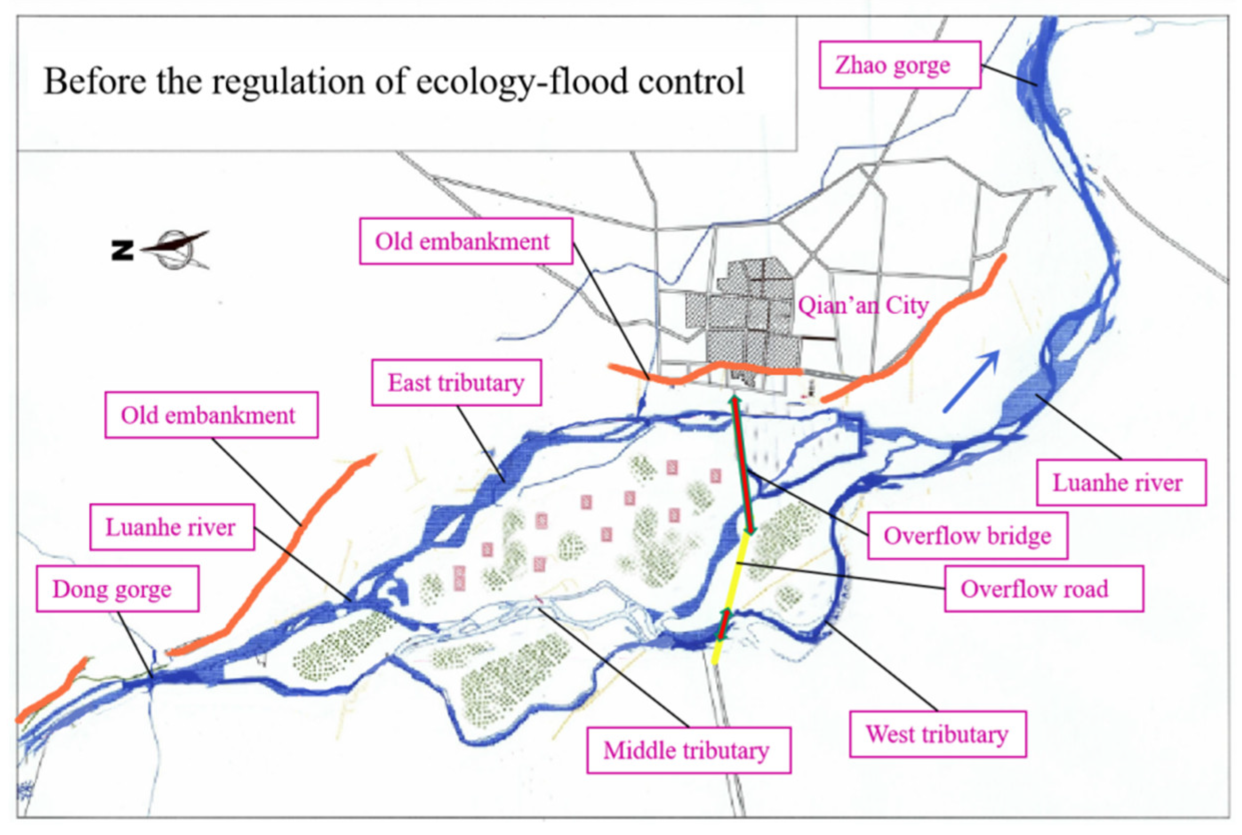
4.2. Current Environment in the Research Area

In recent years, rivers in the region have at times entirely lost flow, and sediment deposition has reduced the size of river channels. The flood transfer capacity has also decreased owing to the sedimentation of river beds caused by water shortages and human activities. Groundwater is also scarce in the study area (Figure 2). The wide floodplain has turned into barren sandy land, which is the source of seasonal spring sandstorms. The river ecological environment has deteriorated.

5. Research Results (Comprehensive Regulation in River Reaches Adjacent to the City)

5.1. Research Results of the Current Environmental Quality in the Research Region

To study the ecological environmental quality of the region, a survey and analysis were conducted, mainly using the following three environmental indicators.
  • Expression model of the ecological elasticity index:
    C S I e c o = i = 1 n S i e c o W i e c o ,
Here, S i e c o represents the characteristic elements within an ecosystem. W i e c o is the corresponding weight value of element i.
2.
Resource bearing index expression mode:
C S I r e s = i = 1 n S i r e s W i r e s ,
Here, S i r e s is the resource component and n = 4. W i r e s is the corresponding weight value of element i.
3.
Environment hosts exponential expressions:
The environmental carrying capacity includes the water, air, and soil environments:
C S I e n v = i = 1 n S i e n v W i e n v ,
Here, S i e n v is the environmental component and n = 3. W i e n v is the corresponding weight value of element i.
By referring to relevant research materials, the weight values used for each expression were determined through an expert evaluation method. The expert evaluation method, also known as the brainstorming method, is commonly used in decision-making processes involved in operations research. It is used to design tables based on the knowledge, experience, and discipline of experts, and the experts determine the weight value of each element in the model calculation based on their own specialty (Table 1).
The survey found an ecosystem resilience index CSIeco value of 39.06 in this area, indicating that capabilities of resisting external forces and undergoing ecosystem recovery are poor. The water resource carrying index CSIres value was found to be 21.34, which can be seen as a low bearing capacity level. The environment carrying capacity index CSIenv was found to be 36.75, which indicates a low level of resources and environmental carrying capacity, indicating weak pressure and a low load level (see Table 1). The flood levee standard for Qian’an City area near the original Luanhe River left bank is very low and some individual sections are incomplete, while there is almost no dike on the right bank. The control project system is imperfect, and the regulation line arrangement is unreasonable. Therefore, the sudden flood threat to city has increased, and the ecological environment quality in the city has deteriorated owing to the condition of the river. This has restricted the development of the waterfront city. The relationship between the river and the adjacent city needs to be improved through comprehensive control.

5.2. Principles and Schemes Involved in Comprehensive Regulation

5.2.1. Basic Principles of the Comprehensive Regulation

Based on the characteristics of the Qian’an reach of the Luanhe River, river flood control should be combined with ecological regulation and city development. Comprehensive regulation measures, including engineering, ecology, and management, could aid river control and ecological restoration and improve the environment during the city’s development, with the aim being to form a harmonious and mutual promotion relationship between the city and the river. During the comprehensive regulation of the river, unity among environmental, economic, and social benefits should be pursued [40].

5.2.2. River Health Assessment

First, based on the characteristics of the riparian zone ecosystem in the Qian’an reach of the Luanhe River, the concept of a healthy river was defined scientifically, and an evaluation index system established. The health hierarchy in the beach ecosystem was divided, and the environmental quality of rivers and beaches was evaluated and analyzed using GIS spatial stack analysis technology support. A flowchart for the study is shown in Figure 3.

5.2.3. Finance Channels for Construction Funds

The regulation of the Qian’an reach of Luanhe River should be closely combined with the planning of urban development near the river, and an integrated renovation program for flood prevention and ecology should be conducted. Funds should be raised for river training from urban construction, taking advantage of the benefits of flood control and the environment to promote the development of the city.

5.2.4. Comprehensive Regulation Schemes

The regulation plans for the Qian’an reach were designed according to the principle noted above. Individual projects are shown in Figure 4, and this is divided into three specific schemes.
  • The levee construction scheme combined with urban traffic network: The embankment was designed with high standards, including enhanced flood control (for levee height), expanded traffic requirements (for levee width), and augmented environment protection (for ecological levee). The sturdy embankment can resist a 50-year recurrent flood; the six-lane broad embankment was designed as a main riverside road in the city’s traffic network through the green way connecting the city and the river; and the green embankment was designed with ecological slope protection materials (such as gabion mesh and grass), forming a beautiful landscape near the river.
  • The river ecosystem restoration construction scheme: The five-stage rubber dams were designed for water conservancy to restore the ditch braided wetland. On the basis of dredging and improving the capacity of river channels, the floodplain wasteland regulation and the green ways along the river channel were designed with high standards to increase the production capacity of the river ecosystem and the biodiversity of the river environment and to restore the ecology elasticity of the river system.
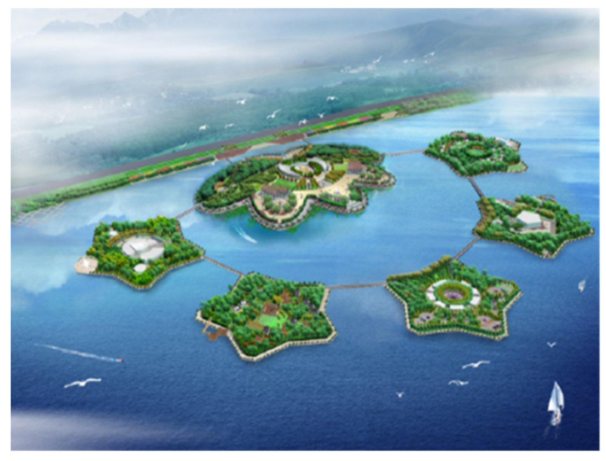
  • The natural and cultural riverside landscape construction scheme: The artificial Huangtai lake and six leisure islands on the lake were designed on the basis of the safety of flood discharge. Scenic river locations and cultural facilities for citizen leisure were developed, and the retreat road was designed to allow citizens to escape flooding. The barren wasteland near the river was changed into high-value urban development land by designing a beautiful environment near the river.

5.3. Study on the Comprehensive Regulation Schemes by Hydraulic Modeling

5.3.1. Constructing the Hydraulic Scale Model

The simulated river is 27 km long and is wide and shallow. The design of the model takes into account the length of the river, test site, water supply capacity, model roughness technology, and flow pattern similarity requirements. According to the gravity similarity and turbulent resistance similarity criteria, a distorted model was designed. The plane geometric scale λl of the overall model was determined to adopt 490. The depth scale λh was 70, so the geometric distortion was η = 7. The velocity scale λv (λv = λh1/2) was approximately 8.37 and Manning roughness scale values λn (λn =λh2/3/λl1/2) approximately 0.77. The two scenarios of the model are called Case S1 (before regulation) and Case S2 (after regulation) (Figure 5).
The flow discharge in the experiment was controlled by an E-mag electromagnetic flow meter, and the flow velocity was measured by a propeller current meter. Surface flow velocity fields were acquired using the VDMS measurement system based on buoy flow measurements. The boundary materials of the river model determined by the roughening test met the model roughness requirements of the trough and beach. Through verification of the historical flood mark, the model was found to meet the requirements of similar resistance (see Table 2).

5.3.2. Results of the Hydraulic Model Test

To investigate the flood characteristics of the studied reach, experiments were conducted using the two river scenarios: Case S1 and Case S2. The design flood was constructed using two standards: a flood return period of P1 = 10% (Q1 = 9000 m3/s) for general town (today’s Qian’an city); and P2 = 2% (Q2 = 19,000 m3/s) for larger cities considering the future development of Qian‘an city.
In Case S1, the river flood performance showed that water flow was divided into left and right branches, and the split ratio of the left bank near city was higher when the flow velocity was 3–4 m/s. The flow was scattered and unstable.
After carrying out the comprehensive regulation project (Case S2), the discharge capacity in the right tributary was found to be enhanced, and the flow was more concentrated in the deep trough. The flood routed smoothly with the new embankment and was not negatively influenced by the regulating projects. The Huangtai artificial lake stabilized the flow along the left bank adjacent to the city, so the nearby flood level was reduced by 0.1–0.2 m when the flow velocity was 2.5–3.0 m/s. In the design flood conditions, the flow fields at Case S1 and Case S1 are shown in Figure 6 and Figure 7 (velocity obtained by the VDMS measurement system in the model test). A comparison of the flow velocity along the left bank between the two schemes (S1 and S2) is shown in Figure 8. The new embankment was found to resist erosion from flooding characterized by a hydraulic slope of 0.11%. This shows that the regulating measures have improved flood discharge capacity in flood channels (Figure 9 and Table 3), and the lakes formed by multistage rubber dams also showed restored ecological function in the non-flood season. This indicates that the comprehensive regulation scheme is reasonable and feasible.

5.4. Major Measures and Effects of the Comprehensive Regulations

5.4.1. Flood Control and Ecological Restoration Engineering

  • A flood control dike with high standards to prevent 50-year recurrent flooding was constructed. According to river flood regulations, a two-sided dike was constructed, regulating a total length of 50.9 km in the Qian’an reach of the Luanhe River. The new flood control dike expanded the urban traffic network. The left bank (adjacent to city) segment length is 24.2 km and the right bank segment length is 26.7 km. A 5.2 km long dike road was built in the urban section with six lanes and a width of 50 m, which meets the high standards required of urban road construction (Figure 10 and Figure 11). The protection side slope of the dike was constructed with pervious ecological slope protection materials such as gabion mesh and interlocking concrete blocks (Figure 12), and grass planted on the waterfront slope and shrubs planted on the back slope. The new dike became a safe green barrier for flood control as well as a convenient traffic artery of Qian’an City. In order to meet the retreat requirements of residents within the river flood zone before the occurrence of flooding, a 6 km long flood control evacuation road and seven retreat bridges were constructed around the lake which form a green way network connecting the city and river.
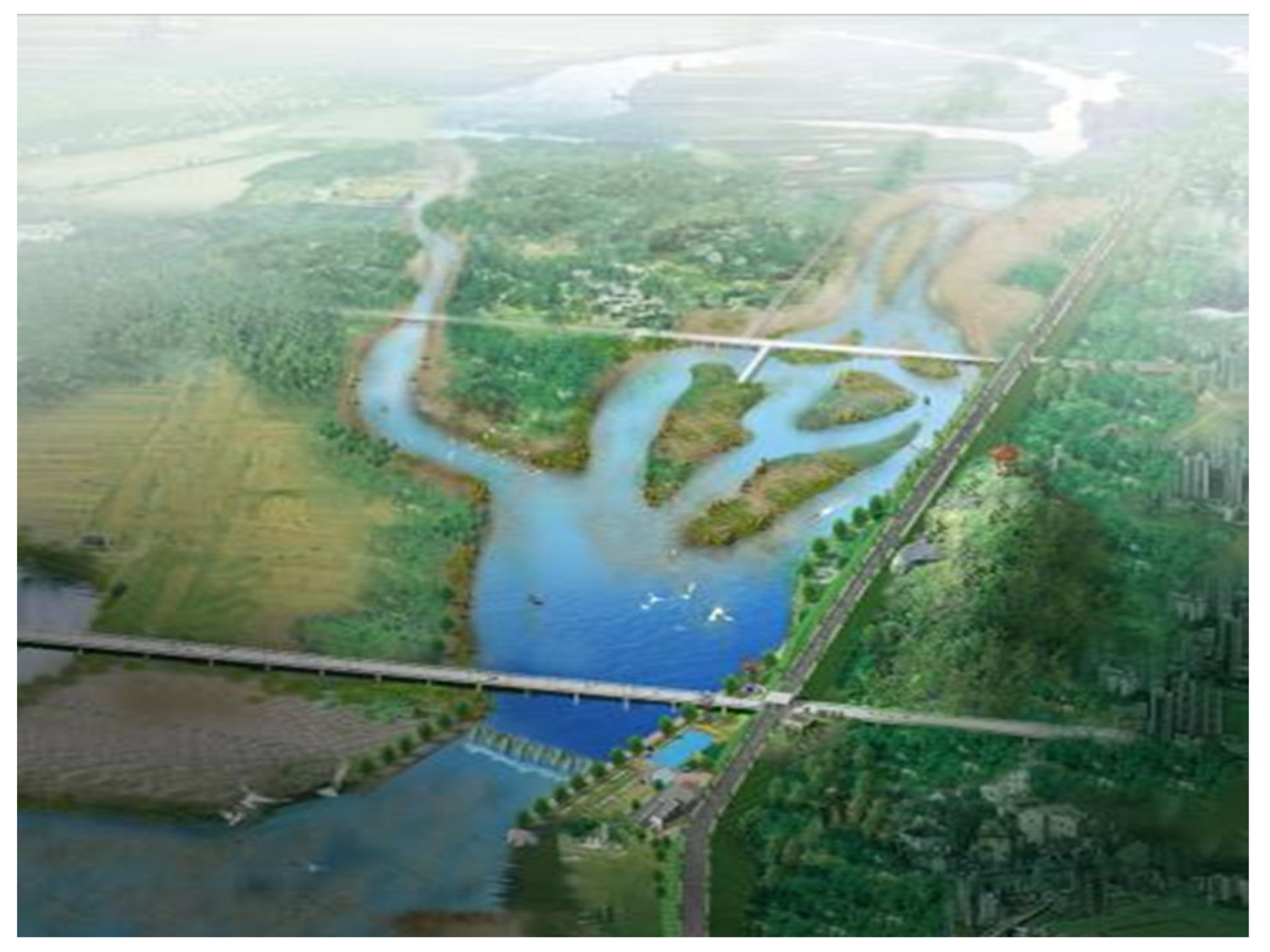
  • A ditch regulation project was conducted using various methods, such as cleaning the riverbed, dredging the braided ditch, and rechanneling shrunk streams for the purpose of resolving the contradictions between flood discharge and development in the floodplain. The layout and scale of regulation engineering were determined based on scientific research conducted under the conditions of the design flood. Rectification projects included the right branch diversion at the middle tributary, detention basin construction between two branches, an artificial lake, water diversion projects in the west tributary, also strengthening of the flood carrying capacity by excavation and dredging on the left side of the main channel (Figure 7).
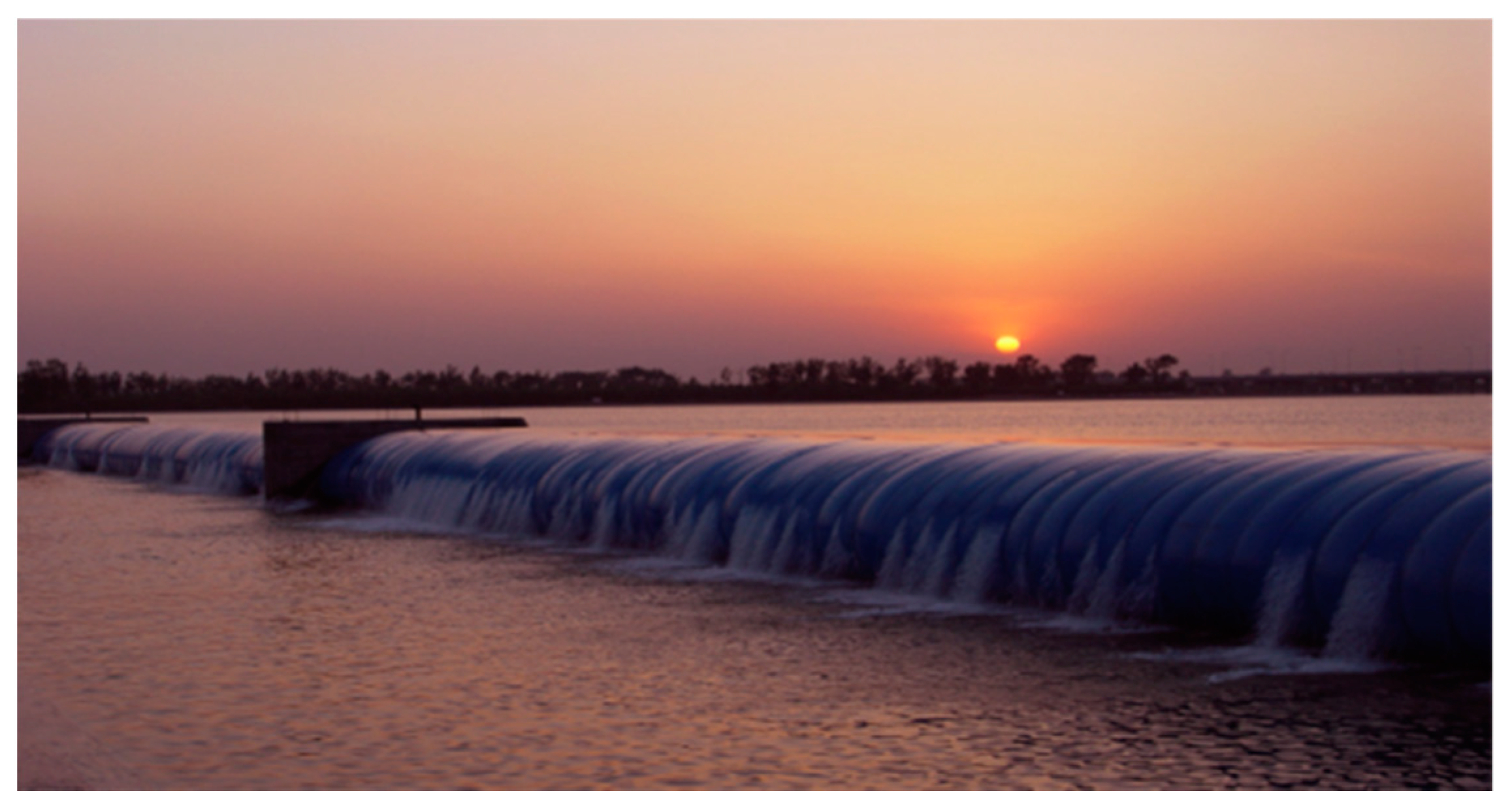
  • Multistage rubber dams were constructed through environmental regulation projects to eliminate the harsh ecological environments of the river and address the shortage of underground water (Figure 12). A cascade control project with five rubber dams was established to supply underground water and transform the sandy wasteland. The formation of water storage bodies can beautify the urban environment and improve local ecological and climatic conditions. Rubber Dam 1 was constructed upstream from the Qian’an valley, where there is a watershed of two branches, similar in shape to a “fish mouth”. Two separating sluices were built in the two branches and were used to control and distribute runoff. The tail water of the final flood was able to flow into the left branch of the planned wetland and artificial lake to achieve flood resource utilization. Rubber Dam 3 is located downstream of the Huangtai artificial lake. It is 330 m long and 2 m high and can store water to form an artificial lake in the left branch. This was done to improve the local environment and eliminate sand dust storms in spring (Figure 13). Rubber Dam 2 is located upstream from the Huangtai lake in the east tributary (near the urban areas), and Rubber Dam 4 is located at the flow intersection downstream from the Huangtai lake. The main role of the two dams is to adjust the water head, restore wetlands, transform sandy wastelands, and improve the river’s ecological environment. Rubber Dam 5 is located at the end of Luanhe River valley to form ecological wetlands. It is 355 m long and 2 m high. The five rubber dams were shown to raise the local river water level appropriately to increase water storage capacity and water area of the river, not only improving the river’s ecological environment but also increasing the water diversion and ecological restoration of the river system significantly. All rubber dams should become flat to discharge water before flooding occurs.

5.4.2. Lake Scenic Engineering for the Non-flood Season

  • Water Storage Projects in the Lake District
This is an important part of typical river ecological engineering, which in this case involved areas including the artificial lake, Lotus Island, and the five star-shape islands. A special embankment protection project was also conducted along the left bank. The excavation of the lake and the filling of islands were conducted according to the natural river regime and the original beach features, using model testing. By using rubber dams in the non-flood season, the water surface maintained an area of 2798 acres, with an average depth of 2–3 m and a maximal depth of 3.5 m in the Huangtai artificial lake. Its storage capacity is as much as 4.3 million m3, forming the rippling lake district (Figure 14). The results of the model test showed that the planned artificial island had little effect on flood discharge, and the left embankment had sufficient strength to prevent flooding. Rubber dams become flat in devastating floods, causing the artificial island to overflow, overtopping naturally, which can guarantee the flood capacity of the river and the safety of the dike.
2.
Wetland Restoration and Renovation Project in the Sandy Wasteland Area
Two large wetland protection areas (wetland parks) around the Huangtai lake and a biological protected area near Dong Gorge were established (Figure 4, Figure 15 and Figure 16). With the rise in water level by rubber dams and the improvement of the flow system by water diversion projects, soil and water conservation projects and partitioned ecological restoration projects were carried out, which included planting trees or grass in the sandy wasteland area of the floodplain. Meanwhile, many green ways were built along the channels. All of these measures greatly improved the river environment.
3.
Landscape Engineering in the Riverfront Region Near the City
A riverfront park with an area of 170,000 m2 was established, forming a beautiful green corridor. Along the riverfront region, many flower terraces, trees, sculptures, landscape stones, monuments, craft lanterns, and various leisure facilities were constructed. This created a riparian quality ecological space accessible both by day and night (Figure 17). The artificial lake and riverfront park complement each other.
By improving the ecological environment of the riverfront, the rapid development of the urban waterfront was promoted, and the river management objective of developing a harmonious relationship between humans and water was realized. The inter-relationships among the city, river, and ecological environment of the river are shown in Figure 18.

5.4.3. Analysis of the Comprehensive Benefits

The degree of development and utilization of land and water resources was determined reasonably through the comprehensive regulation schemes. Since the gradual implementation of the dike project and ecological engineering projects, such as the Huangtai lake and wetland restoration, the river ecological environment improved significantly. There is an abundance of fish in the lake, and the population of fish increased more than tenfold. The area of river wetlands greatly increased, and a large number of birds returned to habitats within the lake district and the river, resulting in the formation of a very beautiful natural landscape and superior ecological environment. The surrounding groundwater level rose significantly, and groundwater resources increased by 80 million m3 in Qian’an City. About 6.5 million acres of riverfront land are now protected from flooding, and 5300 acres of former wasteland transformed into high-value urban construction land. The implementation of the project ensured the safety of river flood control, improved the river and its surrounding ecological environment, and promoted city development. The comprehensive regulation projects not only achieved good economic benefits, but also led to significant environmental and social benefits, which obtained from four aspects are shown in Figure 19. which preliminarily achieved harmony between the river and humans. The goal of harmony between the river and humans has been preliminarily achieved.

6. Conclusions

  • According to the concept of harmony between humans and rivers, the basic theory of comprehensive river regulation adjacent to a city is described. The relations among flood control, environment improvements, and urban development during river regulation should be dealt with carefully. A new financing channel for water conservation construction funds has been recommended in order to obtain sufficient financial support from city development.
  • As a typical case study example, taking a reach of the Luanhe River adjacent to a city in North China, a comprehensive regulation model was proposed based on an assessment of current river health. The schemes included a flood control project, river regulation, ecological restoration, landscape construction, multipurpose road building, and the configuration relationship. The scheme feasibility was studied and verified through a hydraulic scale model test.
  • In the regulated reach of the river, a flood control embankment (taking the urban traffic into account), multilevel rubber dams, an artificial lake, and a riverfront landscape belt were constructed, and river dredging, wetland restoration, and improvement of the layout of green ways were carried out. The engineering practices showed obvious effects of the implementation of comprehensive river regulation. Good economic benefits and significant environmental and social benefits were achieved. The harmony between the river and humans improved, and mutual promotion and coordinated development of the city and the river was preliminarily realized.

Author Contributions

Conceptualization, M.D. and D.S.; methodology, L.Y.; software, M.L.; validation, L.Y., J.Z. and M.D.; formal analysis, M.D.; investigation, M.L.; resources, J.Z.; data curation, D.S.; writing—original draft preparation, M.D.; writing—review and editing, D.S.; visualization, M.D.; supervision, L.Y.; project administration, L.Y.; funding acquisition, M.L. All authors have read and agreed to the published version of the manuscript.

Funding

This research was funded by National Natural Science Foundation of China, grant number 52079053, 41930643; Key Scientific Research Projects in Colleges and Universities of Henan Province, grant number 21A570002. And The APC was funded by 52079053.

Institutional Review Board Statement

Not applicable.

Informed Consent Statement

Not applicable.

Data Availability Statement

Not applicable.

Acknowledgments

The present study is carried out under the financial support of the National Natural Science Foundation of China (Grant Nos. 52079053, 41930643); Key Scientific Research Projects in Colleges and Universities of Henan Province (Grant Nos. 21A570002). The authors gratefully acknowledge this support.

Conflicts of Interest

The authors declare no conflict of interest.

References

  1. Zuo, Q.; Luo, Z.; Ding, X. Harmonious development between socio-economy and river-lake water systems in xiangyang city, china. Water 2016, 8, 509. [Google Scholar] [CrossRef] [Green Version]
  2. Sofi, M.S.; Bhat, S.U.; Rashid, I.; Kuniyal, J.C. The natural flow regimea: Master variable for maintaining river ecosystem health. Ecohydrology 2020, 13, e2247. [Google Scholar] [CrossRef]
  3. Macklin, M.G.; Panyushkina, I.P.; Toonen, W.; Chang, C.; Prins, M.A. The influence of late pleistocene geomorphological inheritance and holocene hydromorphic regimes on floodwater farming in the talgar catchment, southeast kazakhstan, central asia. Quat. Sci. Rev. 2015, 129, 85–95. [Google Scholar] [CrossRef]
  4. Olsson, G. Urban water supply automation—Today and tomorrow. AQUA—Water Infrastruct. Ecosyst. Soc. 2020, 70, 420–437. [Google Scholar]
  5. Izham, M.Y.; Aznarahayu, R.; Azni, M.A.N.; Norashila, M.N. The river basin spatial informative nesting (e-basin) framework as an alternative approach for flood disaster management. IOP Conf. Ser. Earth Environ. Sci. 2019, 380, 012005. [Google Scholar] [CrossRef]
  6. Nurhamidah, N.; Junaidi, A.; Nz, A.H. Decision support system for flood management in batang arau river basin. E3S Web Conf. 2020, 156, 04005. [Google Scholar] [CrossRef] [Green Version]
  7. Wang, H.; Zhao, Y. Preliminary study on harnessing strategies for yellow river in the new period. J. Hydraul. Eng. 2019, 50, 1291–1298. [Google Scholar]
  8. Zhao, H.J.; Jin, Y.D.; Liu, J. Application of roughening with the grass cushions in the hydraulic model of comprehensive harness of qian’an reach of luan river. Appl. Mech. Mater. 2013, 405–408, 2096–2099. [Google Scholar] [CrossRef]
  9. Mecklenburg, D.E.; Jayakaran, A.D. Dimensioning the Sine-Generated Curve Meander Geometry. J. Am. Water Resour. Assoc. 2012, 48, 635–642. [Google Scholar] [CrossRef]
  10. Qian, N. Fluvial Process Theory; Science Press: Beijing, China, 1988. [Google Scholar]
  11. Wong, M.; Parker, G. Reanalysis and correction of bed-load relation of Meyer-Peter and Müller using their own database. J. Hydraul. Eng. 2006, 132, 1159–1168. [Google Scholar] [CrossRef] [Green Version]
  12. Han, Q. Exchange between coarse and fine particles during deposition and erosion along river. In Proceedings of the tenth International Symposium on River Sedimentation, Moscow, Russia, 1–4 August 2007; pp. 136–144. [Google Scholar]
  13. Wang, W.; Li, C.Q. River corridor and Ecosystem restoration. Water Resour. Hydropower Eng. 2003, 34, 56–58. [Google Scholar]
  14. Guimares, L.F.; Teixeira, F.C.; Pereira, J.N.; Becker, B.R.; Miguez, M.G. The challenges of urban river restoration and the proposition of a framework towards river restoration goals. J. Clean. Prod. 2021, 316, 128330. [Google Scholar] [CrossRef]
  15. Shang, J.; Zhang, W.; Chen, X.; Li, Y.; Zhang, H. How environmental stress leads to alternative microbiota states in a river ecosystem: A new insight into river restoration. Water Res. 2021, 203, 117538. [Google Scholar] [CrossRef] [PubMed]
  16. Fu, B.; Ying, L.; Wang, Y.; Campbell, A.; Jin, X. Evaluation of riparian condition of songhua river by integration of remote sensing and field measurements. Sci. Rep. 2017, 7, 2565. [Google Scholar] [CrossRef] [Green Version]
  17. Bin-Yi, L.; Chang, Y.U. Greenway Networks Planning of USA and Its Apocalypse to Us. J. Chin. Landsc. Archit. 2001, 6, 77–81. [Google Scholar]
  18. Steiner, F.R. The Living Landscape: An Ecological Approach to Landscape Planning, 2nd ed.; Island Press: Washington, DC, USA, 2003. [Google Scholar]
  19. Chen, M. Approach to the Design of Building an Ecologic River. Pearl River 2005, 26, 11. [Google Scholar]
  20. Sadat, M.A.; Guan, Y.; Zhang, D.; Shao, G.; Cheng, X.; Yang, Y. The associations between river health and water resources management lead to the assessment of river state. Ecol. Indic. 2020, 109, 105814. [Google Scholar] [CrossRef]
  21. Wei, Z.; Wang, G.; Liu, L. Flood control impact assessment of tai’an viaduct (across panwen river) on qingdao lanzhou expressway. IOP Conf. Ser. Earth Environ. Sci. 2021, 643, 012132. [Google Scholar] [CrossRef]
  22. Gao, J.; Zhang, M.; Hu, Z.; Shan, W. Influence of expressway construction on the ecological environment and the corresponding treatment measures: A case study of changyu (changchun-fuyu lalin river) expressway, china. Nat. Environ. Pollut. Technol. 2020, 19, 1195–1201. [Google Scholar]
  23. Rees, G.N.; Cook, R.A.; Ning, N.; Mcinerney, P.J.; Nielsen, D.L. Managed floodplain inundation maintains ecological function in lowland rivers. Sci. Total Environ. 2020, 727, 138469. [Google Scholar] [CrossRef]
  24. Markussen, L.M.; Hansen, S.B.; Olsen, L.K. Groundwater challenges in the limestone during construction of metro and roadway tunnels to a new waterfront city district in Copenhagen. In Engineering in Chalk: Proceedings of the Chalk 2018 Conference; ICE Publishing: London, UK, 2018; pp. 175–180. [Google Scholar]
  25. Zhou, G.; Zhou, L.; Ji, Y.; Lv, X.; Zhou, M. Basin integrity and temporal-spatial connectivity of the water ecological carrying capacity of the yellow river. Chin. J. 2021, 66, 2785–2792. [Google Scholar] [CrossRef]
  26. Zhang, H.; Cheng, X.; Jin, L.; Zhao, D.; Zheng, K. A method for estimating urban flood-carrying capacity using the vis-w underlying surface model: A case study from wuhan, china. Water 2019, 11, 2345. [Google Scholar] [CrossRef] [Green Version]
  27. Xiao, H.; Jia, J.; Chu, Q.; Liu, L. Effect of river ecological restoration by symbiotic system of aquatic plants. IOP Conf. Ser. Earth Environ. Sci. 2021, 621, 012086. [Google Scholar] [CrossRef]
  28. Wang, W.; Li, C.Q. Investigation on landscape design for urban river. J. Hydraul. Eng. 2003, 8, 42–47. [Google Scholar]
  29. Wang, Y.H. Advances in landscape ecology research. J. Yangtze Univ. Nat. Sci. Ed. Agric. Sci. 2005, 2, 79–83. [Google Scholar]
  30. Liu, J.; Wang, Y.; Zhao, L.; Guo, H. Urban river landscape planning based on landscape evaluation: A case study of panlong river in kunming. Acta Sci. Nat. Univ. Pekinensis. 2019, 55, 189–196. [Google Scholar]
  31. Shi, H.; Lu, J.; Zheng, W.; Sun, J.; Ding, D. Evaluation system of coastal wetland ecological vulnerability under the synergetic influence of land and sea: A case study in the yellow river delta, china. Mar. Pollut. Bull. 2020, 161, 111735. [Google Scholar] [CrossRef]
  32. He, S.Y.; Yang, H.J. Scale of ecological recovery in urban river. Water Resour. Hydropower Northeast. China 2005, 10, 40–42. [Google Scholar]
  33. Li, J.; Chen, X.; Zhang, X.; Huang, Z.; Zhang, C. Fish biodiversity conservation and restoration, yangtze river basin, china, urgently needs ‘scientific’ and ‘ecological’ action. Water 2020, 12, 3043. [Google Scholar] [CrossRef]
  34. Yi, S.; Wu, P.; Peng, X.; Tang, Z.; Guo, W. Biodiversity, environmental context and structural attributes as drivers of aboveground biomass in shrublands at the middle and lower reaches of the yellow river basin. Sci. Total Environ. 2021, 774, 145198. [Google Scholar] [CrossRef]
  35. Muftin, F.S.; Nashaat, M.R.; Farhan, R.K. The epipelic algal community in tigris river and the effect of rasheed power plant effluents on its biodiversity. J. Phys. Conf. Ser. 2020, 1664, 012132. [Google Scholar] [CrossRef]
  36. Dong, H.P.; Huang, W. Brief Talk on City River Realignment and Landscape Design. Des. Hydroelectr. Power Stn. 2005, 2, 48–51. [Google Scholar]
  37. Zheng, Y.H.; Wang, Y.P.; Liu, C.R.; Ying, Z. Study on landscape ecology compensatory design of old urban riverside area. In Proceedings of the 2011 International Conference on Consumer Electronics, Communications and Networks (CECNet), Xianning, China, 16–18 April 2011; pp. 1711–1714. [Google Scholar]
  38. Deng, D.J.; Chen, Q.; Chen, L.H.; Xie, X.C. Research on design approach to river landscape in small cities and towns--taking the dongyang river of zhouning county as an example. J. Hebei North. Univ. Soc. Sci. Ed. 2015, 31, 61–64. [Google Scholar]
  39. Zhang, T.T.; Zhao, F.; Wang, S.K.; Zhuang, P. Inspiration of the chesapeake bay project on ecological restoration of fishery for the yangtze river estuary. Mar. Fish. 2017, 39, 713–722. [Google Scholar]
  40. Tang, T.; Cai, Q.; Liu, J. River ecosystem health and its assessment. Chin. J. Appl. Ecol. 2002, 13, 1191–1194. [Google Scholar]
Figure 1. Sketch of the Qian’an reach of the Luanhe River.
Water 14 01413 g001
Figure 2. Distribution of groundwater resources in the Qian’an region.
Water 14 01413 g002
Figure 3. The working procedure used for the river health assessment.
Water 14 01413 g003
Figure 4. The working procedure and specific techniques used.
Water 14 01413 g004
Figure 5. The hydraulic model of the regulated reach of the Luanhe River. (a) The model before regulation (Case S1). (b) The model after regulation (Case S2).
Water 14 01413 g005
Figure 6. Flood field after implementation of the regulations along the Luanhe River for the design flood. (a) The flood field after implementation of the regulations across the whole river (Case S2). (b) Local velocity field of the artificial lake (Case S2).
Water 14 01413 g006
Figure 7. The flow field (water level and velocity) for cases S1 and S2 for the design flood. (a) Case S1; (b) Case S2.
Water 14 01413 g007
Figure 8. Comparison between Case S1 and Case S2 for the velocity along the left bank.
Water 14 01413 g008
Figure 9. Comparison between Case S1 and Case S2 for the water surface along the left bank (two flood frequencies Q1 and Q2).
Water 14 01413 g009
Figure 10. Green dikes adopting ecological slope protection materials.
Water 14 01413 g010
Figure 11. Water storage projects in the Huangtai lake district.
Water 14 01413 g011
Figure 12. Ecological protection slope with different materials. (a) Gabion mesh in the building. (b) Interlocking concrete blocks. (c) Ecological protection slope of the dike.
Water 14 01413 g012
Figure 13. The landscape at Rubber Dam 3.
Water 14 01413 g013
Figure 14. Artificial lake and islands by rubber dams.
Water 14 01413 g014
Figure 15. Wetland restoration projects.
Water 14 01413 g015
Figure 16. Wetland restoration and renovation project in the sandy wasteland area.
Water 14 01413 g016
Figure 17. Scenic area of the riverfront landscape. (a) Cultural landscape. (b) Riverside park.
Water 14 01413 g017
Figure 18. The inter-relationships among the city, river and ecological environment addressed in Luanhe River regulation projects.
Water 14 01413 g018
Figure 19. The economic benefits of the comprehensive treatment project.
Water 14 01413 g019
Table 1. Results of ecological assessment of regional water environment.
Ecological Elasticity IndexResource Carrying IndexEnvironmental Carrying IndexWater Resources Carry PressureLand Carry Pressure
Assignment39.0621.3436.7511.6141.88
Assessment levelThe ability to resist external forces and recover is relatively poor.Water resources have a low carrying capacityThe carrying capacity of environmental resources is low.Severe water shortage.There is a large surplus of land resources in the watershed.
Overall ratingThe bearing capacity of the basin has a low load and weak pressure degreeConservation and regulation of water resources is needed, as is land development
Table 2. Comparison validation of water levels investigated from the past flood mark and measured using the model.
Location of the Flood Mark Investigated Water Level at the Flood Mark in 1994 (m)Measured Water Level at the Flood Mark by the Model (m)Error (m)
Left bank166.7466.60−0.14
Right bank163.9063.970.07
Left bank262.4362.520.09
Left bank349.6449.770.13
Right bank249.3249.180.16
Right bank345.8845.980.10
Table 3. Flood level at the left and right banks (P2 = 2%, Q2 = 19,000 m3/s).
Flood Water Level along the Left BankFlood Water Level along the Right Bank
No.Distance
(km)
Zb
(m)
Za
(m)
Difference (m)No.Distance
(km)
Zb
(m)
Za
(m)
Difference (m)
10.16 67.87 67.79 0.08 24.19 64.34 64.18 0.16
33.91 63.51 63.52 0.00 510.52 54.97 55.01 −0.05
48.74 58.36 58.35 0.01 714.96 52.88 52.68 0.20
613.29 53.42 53.15 0.27 818.18 50.11 50.10 0.01
1023.51 47.89 47.74 0.14 922.73 49.08 48.97 0.10
Note: Zb and Za represent the flood level before and after implementation of the regulations, respectively.
Publisher’s Note: MDPI stays neutral with regard to jurisdictional claims in published maps and institutional affiliations.

