
Application of the HEC-RAS Program in the Simulation of the Streamflow Hydrograph for Air Lakitan Watershed


Abstract
:1. Introduction
2. Methods
2.1. Data and Investigation
- Location (administrative, coordinates, river name, and others).
- Determination of the measurement location boundary and topographic reference point.
- Water sources and irrigation water availability.
- Condition of irrigation networks (maps and schemes).
- Irrigation management status.
- Water supply, distribution, and water supply plans, cropping plans, drying plans, etc.
- Estimated area of the service area to be irrigated.
- Estimated benefits derived from plans for building a water divider building (tapping building).
- Institutional irrigation Operation and Maintenance (OM).
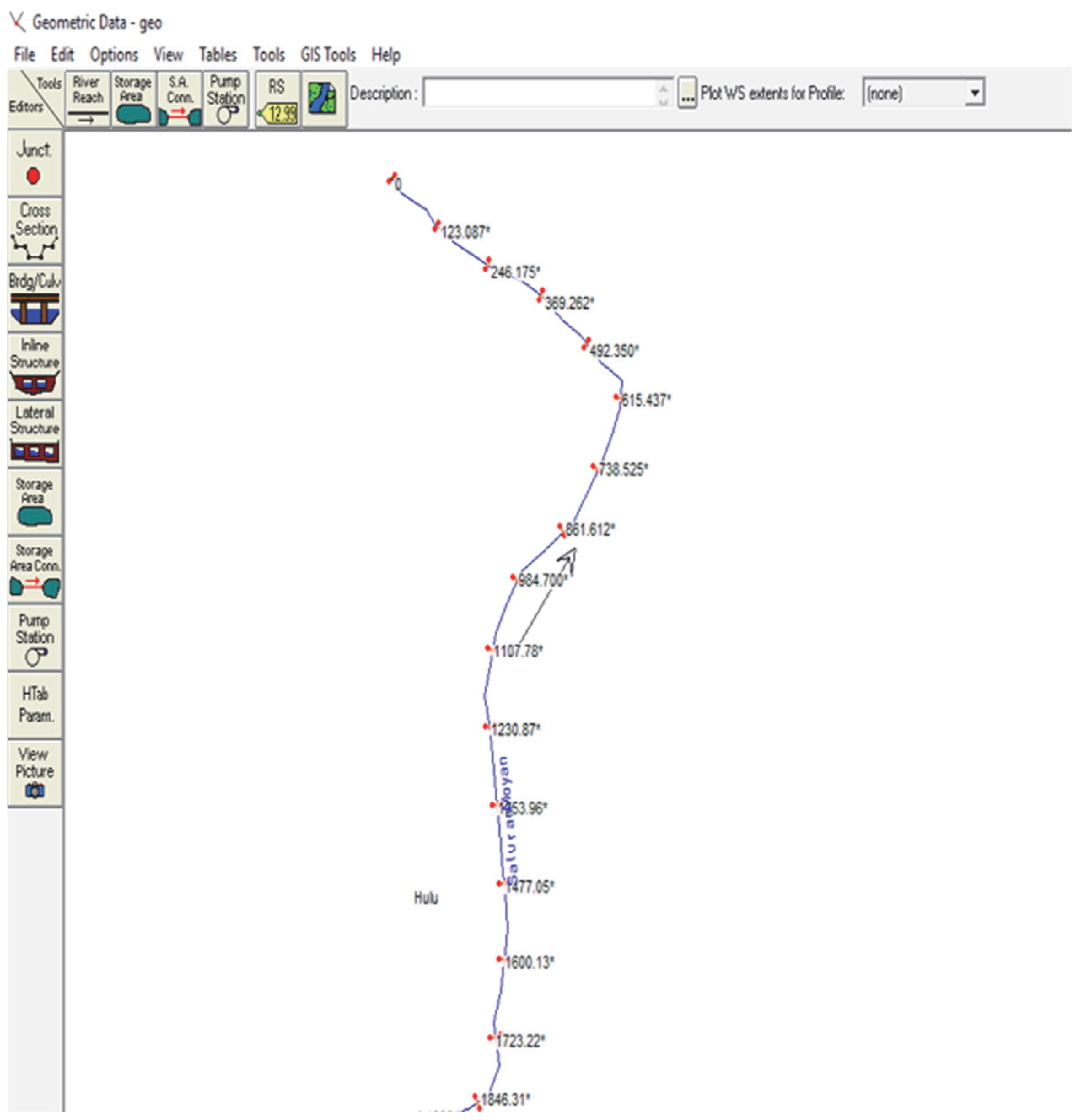
2.2. Research Location
3. Hydrograph Stream Flow Analysis
- (1)
- Dispersion of logarithms is normally distributed (two parameters). Characteristics: the constants Cs = 3 Cv and Cs are always positive; mathematical formula for a probability line: x(t) = x + K; x(t) = rainfall depth, with t being the return period (years); K = frequency factor.
- (2)
- Probability is spread out evenly in a normal fashion. Characteristics: expected value of Cs = 0; P(x − S) = 15.87%; P(x) = 50.00%; P(x + S) = 84.14%. Variables with values between −S and +S have a 68.27% chance of occurring, while values between −X and +X have a 95.44% chance.
- (3)
- Dispersion of Gumbel type I. Characteristics: Cs = 1.3960 cv; Ck = 5.4002; mathematical formula for a probability line:with: yn is the mean value and σn is reduced variated of standard deviation; y is reduced variated and σ is standard deviation.
- (4)
- Log-Pearson Type III distribution. There is no evidence that the statistical data follows any of the three aforementioned distributions. The accumulated precipitation is converted to its natural logarithm, with xi values replaced by ln xi. Once this is done, it can be computed for the mean, standard deviation, and skewness coefficient:
- Determination of the length of the rain data series (for example, n years).
- Data for each year are broken down from large to small.
- For each year, the data are taken (k + 1) the largest data, where k is the number of events equaled or exceeded in the desired year. n years are obtained from n × (k + 1) data.
- The new data set is sorted from large to small.
- Rainfall with probability equaled or exceeded k times a year is data in order (n × k + 10).
4. Results and Discussion
4.1. Statistical Data Analysis
4.2. Time of Concentration (tc)
4.2.1. Kraven Formula
4.2.2. Rhiza Formula
4.2.3. Kirpich Formula
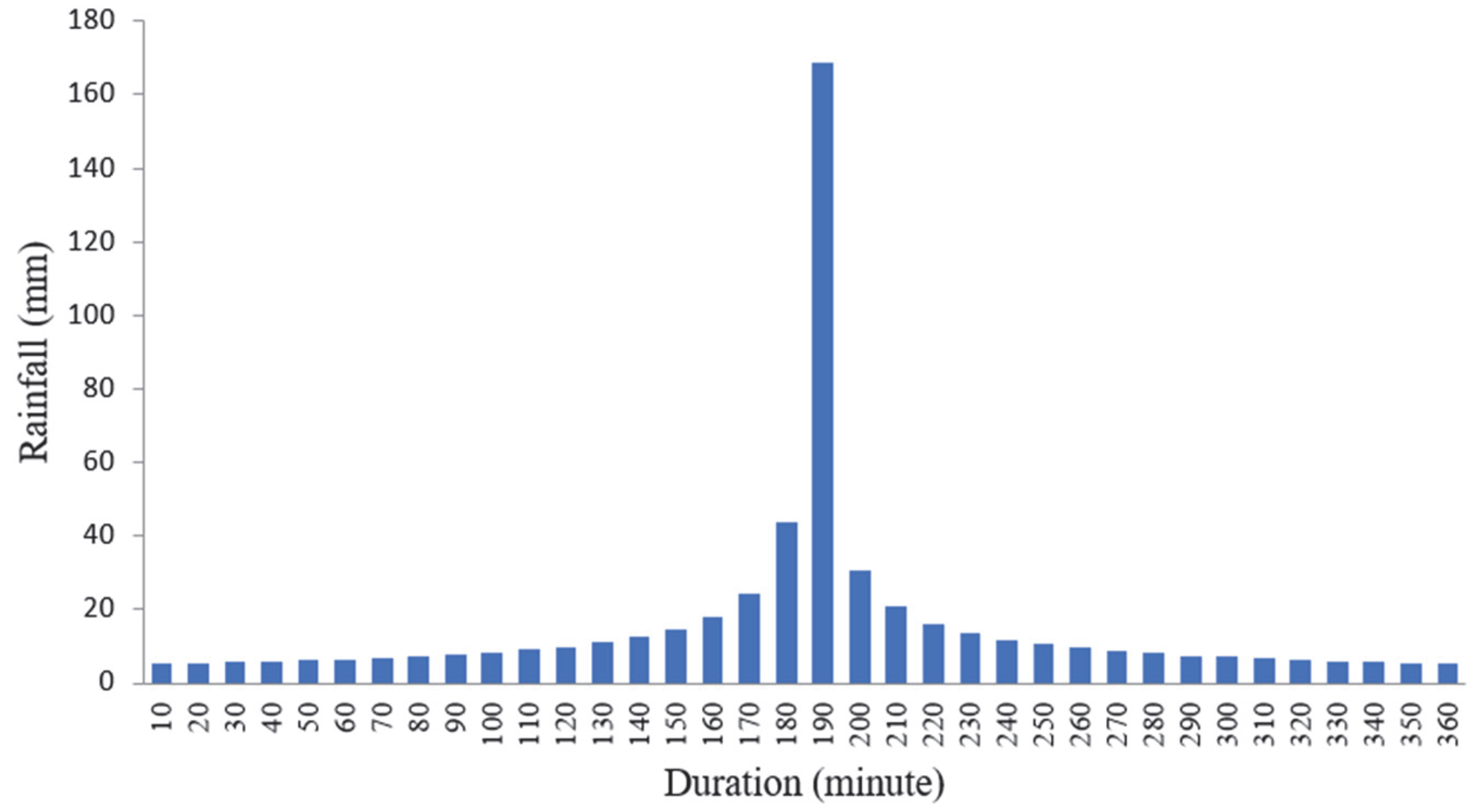
4.3. Rainfall Intensity
4.3.1. Ishiguro
4.3.2. Mononobe
4.4. Hydrodynamic Modeling Analysis
4.5. HEC-RAS Program
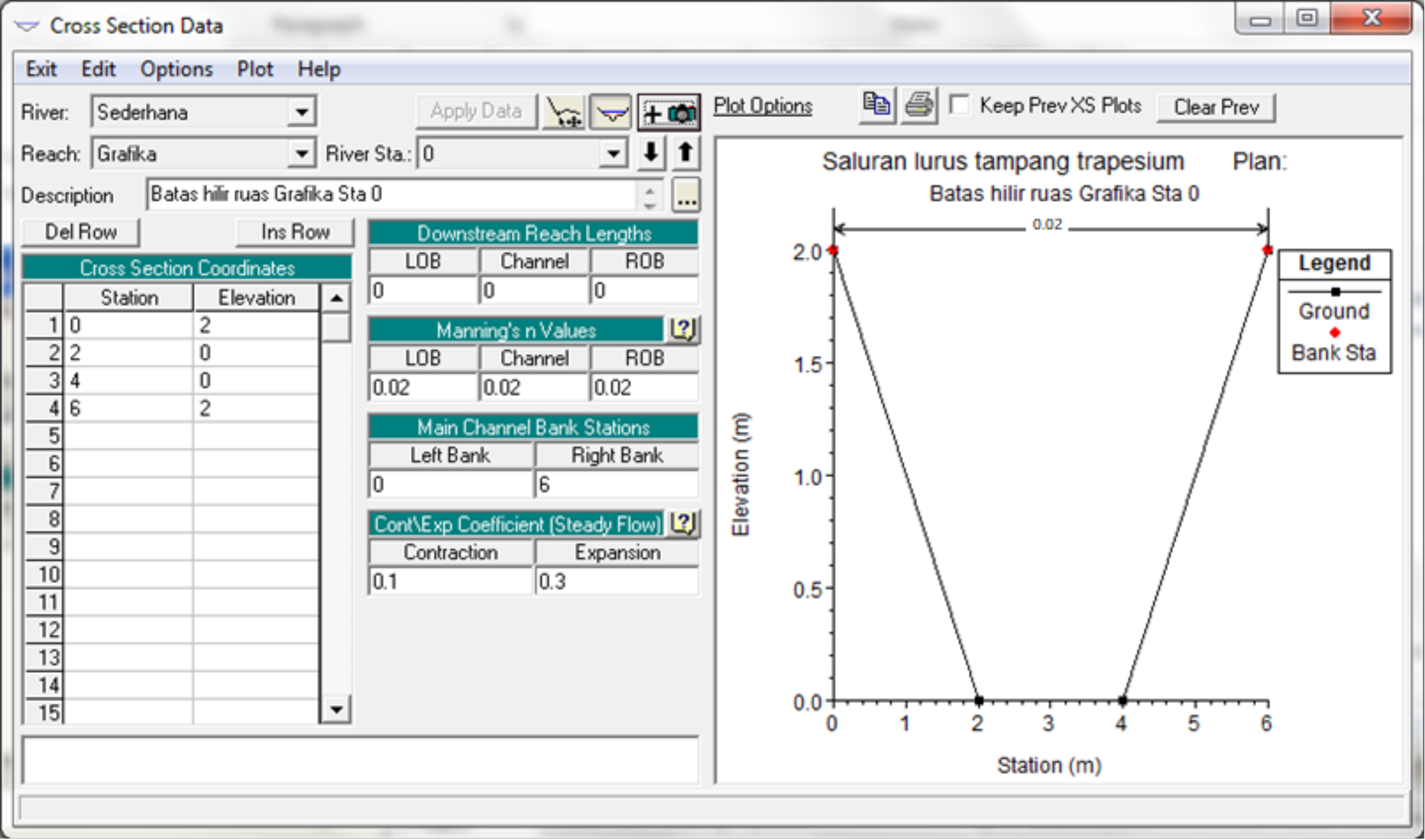
Cross Section Data
- The coordinates (Station, Elevation) of the latitude points on the River Sta are as follows: (0, 3), (2, 1), (4, 1), (6, 3). Remember, the base slope of the channel is 0.001 so the elevation at River Sta “1000” is 1 m above the elevation at River Sta “0” [18].
- Fill in the distance of the River Sta section “1000” to the downstream reach lengths with the number “1000” (the unit of length is meters), both for LOB, Channel, and ROB [19].
- Fill in Manning’s n Values, Main Channel Bank Stations, and Cont\Exp Coefficients do not need to be changed [20].
4.6. Data Input
5. Conclusions
- The Log-Pearson Type III distribution is the frequency distribution that matches the hydrological analysis in the research area. This method can be applied in analyses of river levels in other areas with heavy rainfall.
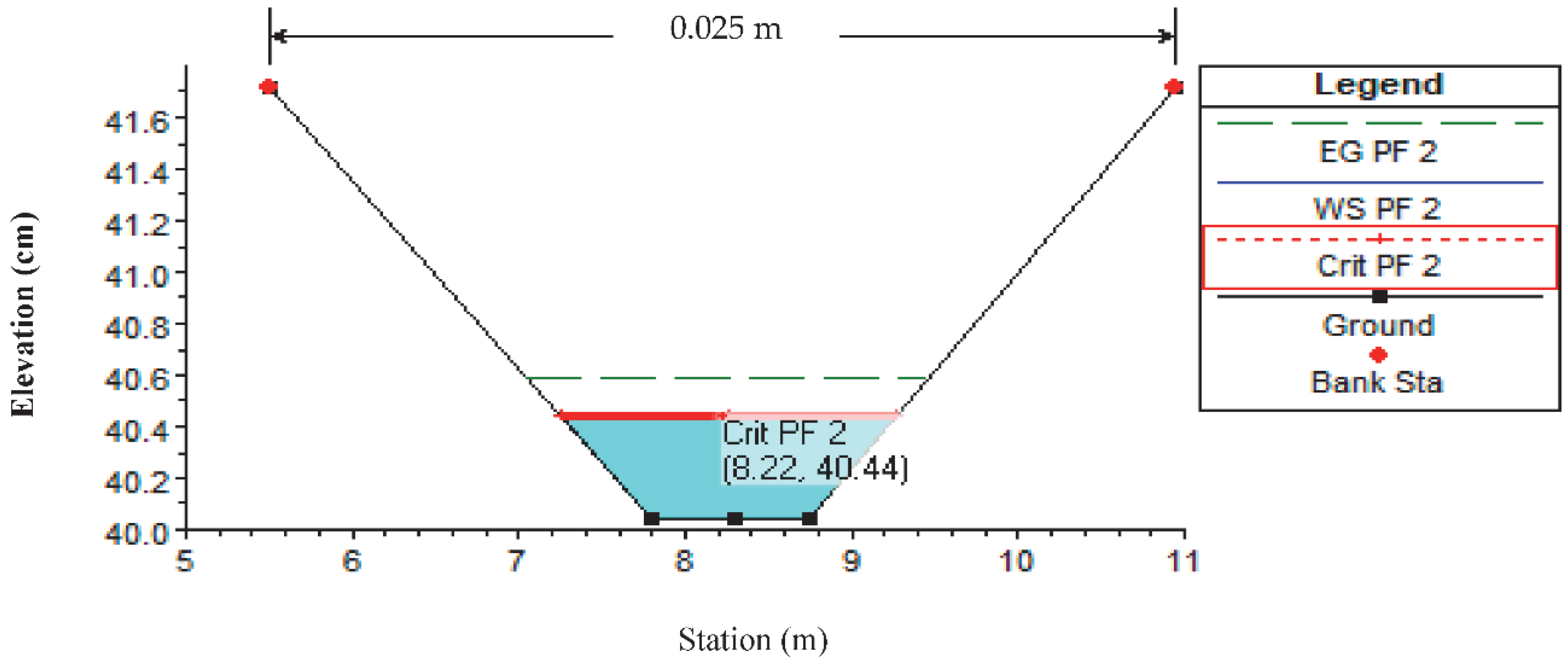
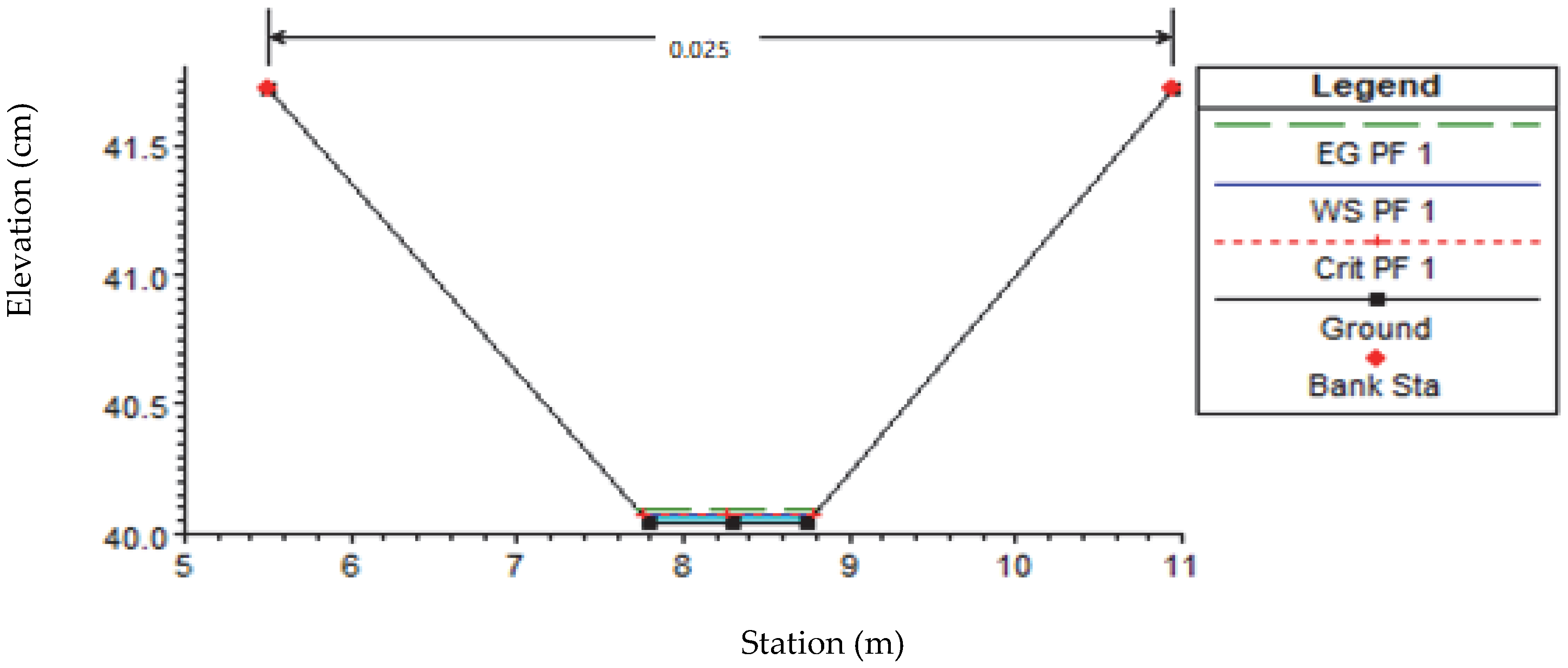
- The water level upstream and downstream is the same at 0.41 m with a discharge of 1 m3/s.
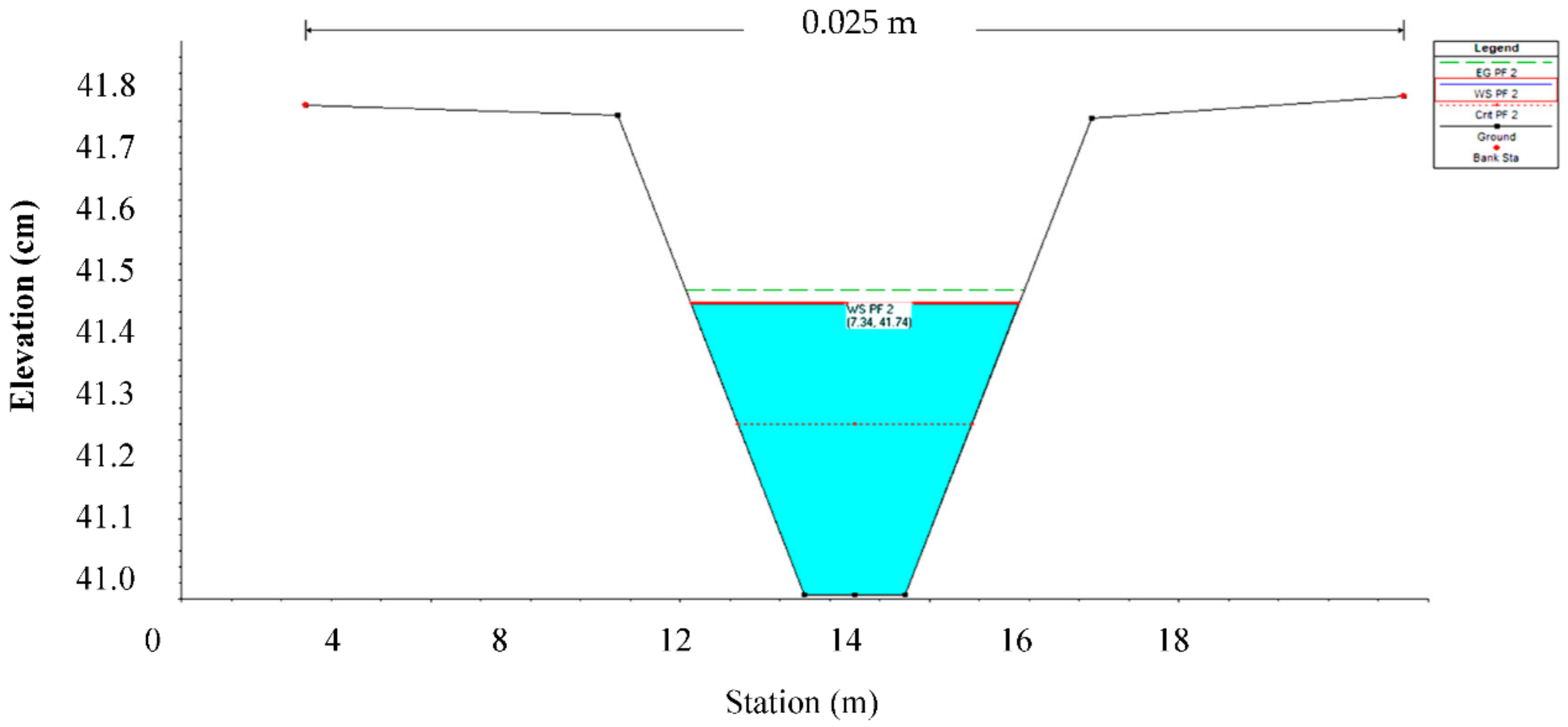
- The river cross-section downstream with the existing discharge of 0.024 m3/s produces water height as high as 0.08 m.
- With a flow rate of 0.783 m/s, the water level at the downstream cross-section is filled up to 0.75 m high, and the water level downstream of the irrigation channel is up to 0.40 m.
Author Contributions
Funding
Acknowledgments
Conflicts of Interest
References
- The Republic of Indonesia Directorate General of Water Resources Ministry of Public Works and Housing. The Project for Assessing and Integrating Climate Change Impacts into the Water Resources Management Plans for Brantas and Musi River Basins (Water Resources Management Plan); Final Report, Volume II Main Report; Japan International Cooperation Agency, Nippon Koei Co., Ltd.: Jakarta, Indonesia, 2019. [Google Scholar]
- Rahardjo, H.; Satyanaga, A.; Harnas, F.R.; Leong, E.C. Use of Dual Capillary Barrier as Cover System for a Sanitary Landfill in Singapore. Indian Geotech. J. 2016, 46, 228–238. [Google Scholar] [CrossRef]
- Rahardjo, H.; Satyanaga, A.; Leong, E.C. Effects of rainfall characteristics on the stability of tropical residual soil slope. In Proceedings of the E-UNSAT 2016, E3S Web of Conferences, Paris, France, 9 September 2016; Volume 15004, pp. 1–6. [Google Scholar] [CrossRef] [Green Version]
- Syarifudin, A.; Satyanaga, A.; Wijaya, M.; Moon, S.-W.; Kim, J. Sediment Transport Patterns of Channels on Tidal Lowland. Fluids 2022, 7, 277. [Google Scholar] [CrossRef]
- CV Tata P’Setya. Final Report Assesment of River Discharge Data Air Lakitan Watershed; Department of Cipta Karya and Musi Rawas Regency Spatial Planning Public Works: Muara Beliti, Indonesia, 2017. [Google Scholar]
- Satyanaga, A.; Rahardjo, H. Unsaturated Shear Strength of Soil with Bimodal Soil-water Characteristic Curve. Geotechnique 2019, 69, 828–832. [Google Scholar] [CrossRef]
- Satyanaga, A.; Rahardjo, H. Stability of Unsaturated Soil Slopes Covered with Melastoma Malabathricum in Singapore. Geotech. Eng. 2020, 7, 393–403. [Google Scholar] [CrossRef]
- Ministry of Public Works and Public Housing of Indonesia. Law Number 7 Concerning Water Resources; Ministry of Public Works and Public Housing of Indonesia: Jakarta, Indonesia, 2004.
- Ministry of Public Works and Public Housing of Indonesia. Law Number 16 Concerning the Formation of the North Musi Rawas Regency; Ministry of Public Works and Public Housing of Indonesia: Jakarta, Indonesia, 2013.
- Syarifudin, A. Applied Hydrology; Andi Publishing Company: Yogyakarta, Indonesia, 2017; pp. 45–48. [Google Scholar]
- Yani, P.R.Y.; Saidah, H.; Wirahman, L. Hourly Rainfall Distribution Pattern at the Cliff Sate Rainfall Station and the Lingkok Lime Rainfall Station in the Central Lombok Region. Civ. Spectr. J. 2021, 8, 41–54. [Google Scholar] [CrossRef]
- Baitullah, A.A.M. HEC-RAS Short Tutorial for Beginners; Faculty of Civil Engineering, Sriwijaya University: Palembang, Indonesia, 2016. [Google Scholar]
- Istiarto. 1-D HEC-RAS Hydrodynamic Program Package for Basic Level of Flow Simulation: Simple Geometry River, Training Module; Springer Nature: Cham, Switzerland, 2014. [Google Scholar]
- Istiarto. Flood Inundation (HEC-GeoRAS), Technical Guidance; Istiarto: Yogyakarta, Indonesia, 2015. [Google Scholar]
- Syarifudin, A.; HRDestania, I.D.F. Curve Patterns for Flood Control of Air Lakitan river of Musi Rawas Regency. In the IOP Conference Series: Earth and Environmental Science, Proceedings of the 1st International Conference on Environment, Sustainability Issues and Community Development, Central Java, Indonesia, 23–24 October 2019; IOP Publishing: Bristol, UK, 2020; Volume 448. [Google Scholar]
- Syarifudin, A.; Destania, H.R. Water Overflow of the Riveranalysis Based on the Computerprogram Simulations (CPS); IAEME Publication: Palavakkam, India, 2020; Volume 11, pp. 125–136. [Google Scholar]
- Syarifudin, A. Environmentally Urban Drainage; Andi Publishing Company: Yogyakarta, Indonesia, 2017; pp. 38–42. [Google Scholar]
- Satyanaga, A.; Wijaya, M.; Zhai, Q.; Moon, S.-W.; Pu, J.; Kim, J.R. Stability and Consolidation of Sediment Tailings Incorporating Unsaturated Soil Mechanics. Fluids 2021, 6, 423. [Google Scholar] [CrossRef]
- Chua, Y.S.; Rahardjo, H.; Satyanaga, A. Structured Soil Mixture for Solving Deformation Issue in GeoBarrier System. Transp. Geotech. 2022, 33, 100727. [Google Scholar] [CrossRef]
- Satyanaga, A.; Rangarajan, S.; Rahardjo, H.; Li, Y.; Kim, Y. Soil Database for Development of Soil Properties Envelope. Eng. Geol. 2022, 304, 106698. [Google Scholar] [CrossRef]
- Li, X.; Wei, X.; Wei, N. Correlating check dam sedimentation and rainstorm characteristics on the Loess Plateau, China. Geomorphology 2016, 265, 84–97. [Google Scholar] [CrossRef]
- Satyanaga, A.; Bairakhmetov, N.; Kim, J.R.; Moon, S.-W. Role of Bimodal Water Retention Curve on the Unsaturated Shear Strength. Appl. Sci. 2022, 12, 1266. [Google Scholar] [CrossRef]
- Syarifudin, A.; Sartika, D. A Scouring Patterns around Pillars of Sekanak River Bridge. J. Phys. IOP Conf. Ser. 2019, 1167, 12019. [Google Scholar] [CrossRef]
- Yongmin, K.; Rahardjo, H.; Nistor, M.M.; Satyanaga, A.; Leong, E.C.; Sham, A.W.L. Assessment of Critical Rainfall Scenarios for Slope Stability Analyses based on Historical Rainfall Records in Singapore. Environ. Earth Sci. 2022, 81, 1–13. [Google Scholar]


| Years | Rainfall (X) | LOG X | (X − Xaverage)2 | (X − Xaverage)3 | (X − Xaverage)4 |
|---|---|---|---|---|---|
| 1989 | 346 | 2.539 | 0.009 | −0.000805 | 0.000075 |
| 1990 | 448 | 2.651 | 0.000 | 0.000007 | 0.000000 |
| 1991 | 518 | 2.714 | 0.007 | 0.000556 | 0.000046 |
| 1993 | 441 | 2.644 | 0.000 | 0.000002 | 0.000000 |
| 1994 | 468 | 2.670 | 0.001 | 0.000055 | 0.000002 |
| 1995 | 417 | 2.620 | 0.000 | −0.000002 | 0.000000 |
| 1996 | 231 | 2.364 | 0.072 | −0.019358 | 0.005198 |
| 1997 | 298 | 2.474 | 0.025 | −0.003937 | 0.000622 |
| 1998 | 558 | 2.747 | 0.013 | 0.001502 | 0.000172 |
| 1999 | 365 | 2.562 | 0.005 | −0.000340 | 0.000024 |
| 2000 | 347 | 2.540 | 0.008 | −0.000773 | 0.000071 |
| 2001 | 626 | 2.797 | 0.027 | 0.004448 | 0.000731 |
| 2014 | 545 | 2.736 | 0.011 | 0.001134 | 0.000118 |
| 2015 | 417 | 2.620 | 0.000 | −0.000002 | 0.000000 |
| 2016 | 634 | 2.802 | 0.029 | 0.004910 | 0.007059 |
| Amount of data | 15 | ||||
| Amount | 39.482 | 0.113 | 0.0144 | 0.014118 | |
| Average | 2.632 | Cs | |||
| Standard of deviation | 0.090 | Ck |
| Distribution Type | Terms | Calculation | Conclusion |
|---|---|---|---|
| Normal | Cs ≈ 0 | Cs = 1.9245 | No, fulfill |
| Ck ≈ 3 | Ck = 9.831 | ||
| Gumbel | Cs = 1.1396 | Cs = 1.9245 | No, fulfill |
| Ck = 5.4002 | Ck = 9.831 | ||
| Log Normal | Cs (ln x) = 0 | Cs (ln x) = −0.2133 | No, fulfill |
| Ck (ln x) = 3 | Ck (ln x) = 3.4689 | ||
| Log-Pearson Type III | Apart from top value | Cs = −0.2133 | Fulfill |
| Ck = 3.4689 |
| T | P(%) | Cs | G | Log X | X (mm) |
|---|---|---|---|---|---|
| 2 | 50 | 0.2133 | −0.0373 | 2.0576 | 114 |
| 5 | 20 | 0.2133 | 0.8376 | 2.1894 | 155 |
| 10 | 10 | 0.2133 | 1.3117 | 2.2608 | 182 |
| 20 | 5 | 0.2133 | 1.7461 | 2.3262 | 212 |
| 25 | 4 | 0.2133 | 1.8329 | 2.3393 | 218 |
| 50 | 2 | 0.2133 | 2.1723 | 2.3904 | 246 |
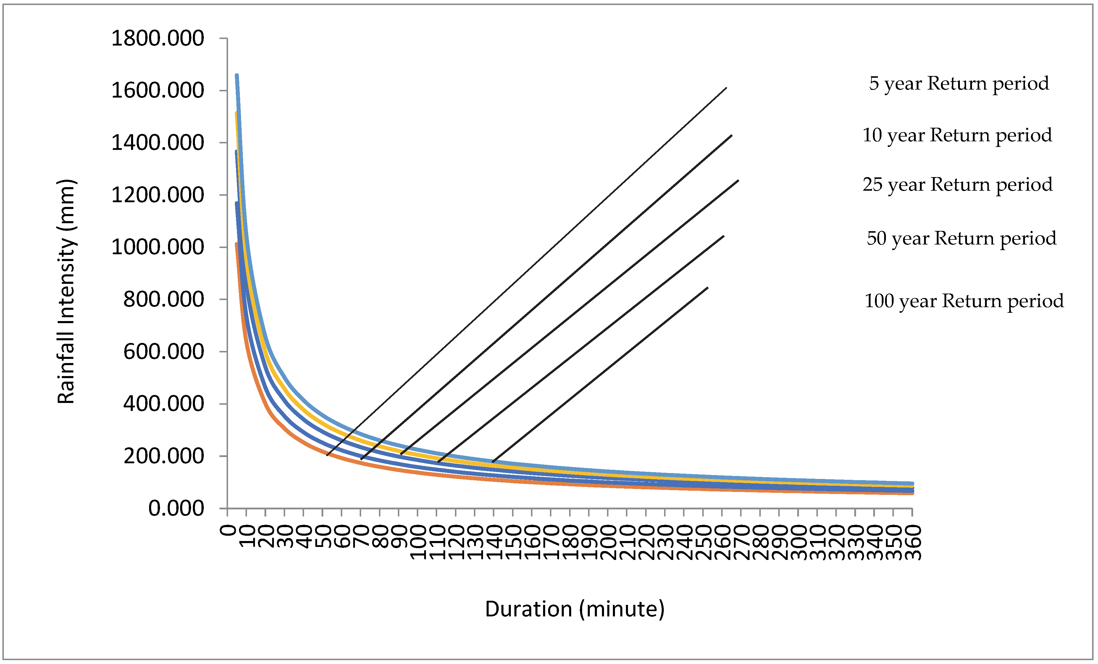
| Tr (Year) | R24 (mm) | I (mm/h) |
|---|---|---|
| 5 | 114 | 45,0343 |
| 10 | 155 | 60,9973 |
| 25 | 182 | 71,8987 |
| 50 | 212 | 83,5867 |
| 100 | 218 | 86,1431 |
Publisher’s Note: MDPI stays neutral with regard to jurisdictional claims in published maps and institutional affiliations. |
© 2022 by the authors. Licensee MDPI, Basel, Switzerland. This article is an open access article distributed under the terms and conditions of the Creative Commons Attribution (CC BY) license (https://creativecommons.org/licenses/by/4.0/).
Share and Cite
Syarifudin, A.; Satyanaga, A.; Destania, H.R. Application of the HEC-RAS Program in the Simulation of the Streamflow Hydrograph for Air Lakitan Watershed. Water 2022, 14, 4094. https://doi.org/10.3390/w14244094
Syarifudin A, Satyanaga A, Destania HR. Application of the HEC-RAS Program in the Simulation of the Streamflow Hydrograph for Air Lakitan Watershed. Water. 2022; 14(24):4094. https://doi.org/10.3390/w14244094
Chicago/Turabian StyleSyarifudin, Achmad, Alfrendo Satyanaga, and Henggar Risa Destania. 2022. "Application of the HEC-RAS Program in the Simulation of the Streamflow Hydrograph for Air Lakitan Watershed" Water 14, no. 24: 4094. https://doi.org/10.3390/w14244094
APA StyleSyarifudin, A., Satyanaga, A., & Destania, H. R. (2022). Application of the HEC-RAS Program in the Simulation of the Streamflow Hydrograph for Air Lakitan Watershed. Water, 14(24), 4094. https://doi.org/10.3390/w14244094