Landscape Ecological Risk Assessment and Planning Enlightenment of Songhua River Basin Based on Multi-Source Heterogeneous Data Fusion
Abstract
:1. Introduction
2. Materials and Methods
2.1. Study Area
2.2. Dataset and Landscape Ecological Risk Assessment Method
2.2.1. Data Sources
- (1)
- Natural dimension indicator data.
- (2)
- Social dimension indicator data.
- (3)
- Landscape pattern dimension indicator data.
2.2.2. Extraction of Land Use Types
2.2.3. Accuracy Verification
2.3. Landscape Ecological Risk Assessment Method
2.3.1. Index Selection of Landscape Ecological Risk Assessment
- (1)
- Natural dimension indicators.
- (2)
- Social dimension indicators.
- (3)
- Landscape pattern dimension indicators.
2.3.2. Landscape Ecological Risk Assessment Method Based on SPCA
3. Results and Discussion
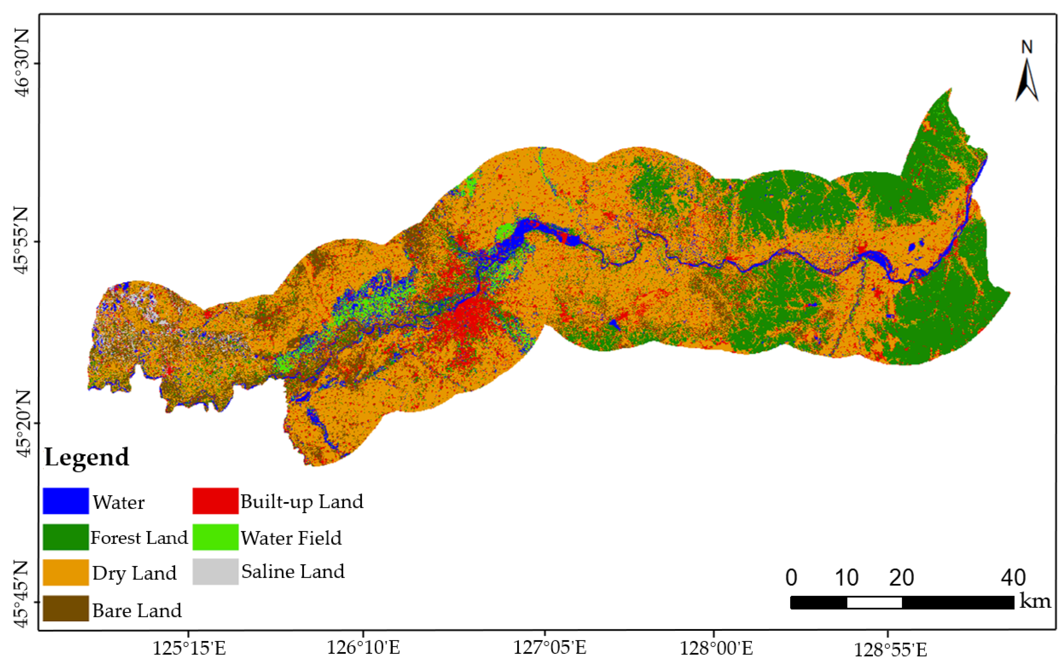
3.1. Extraction of Land Use Types
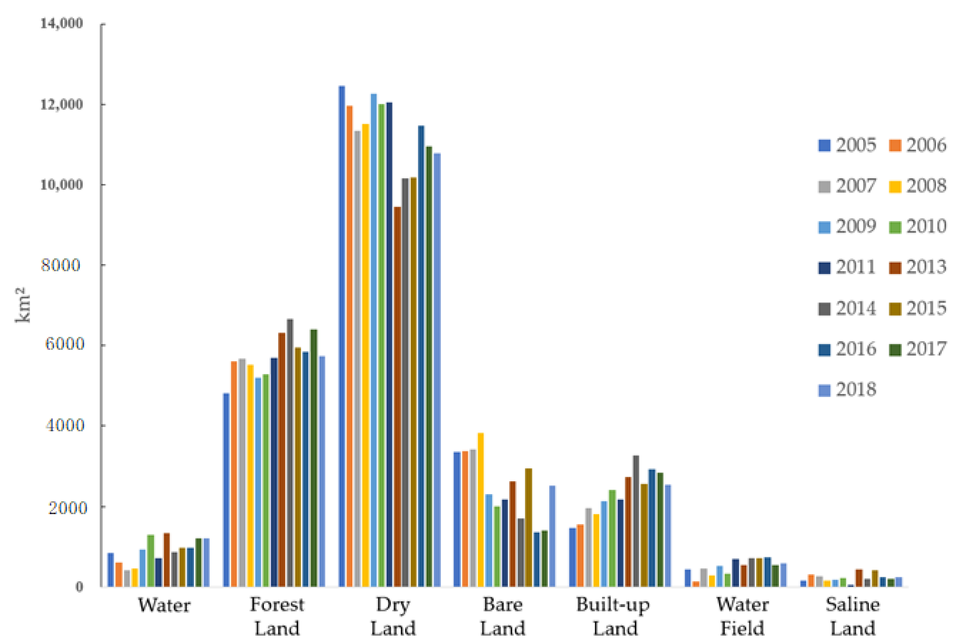
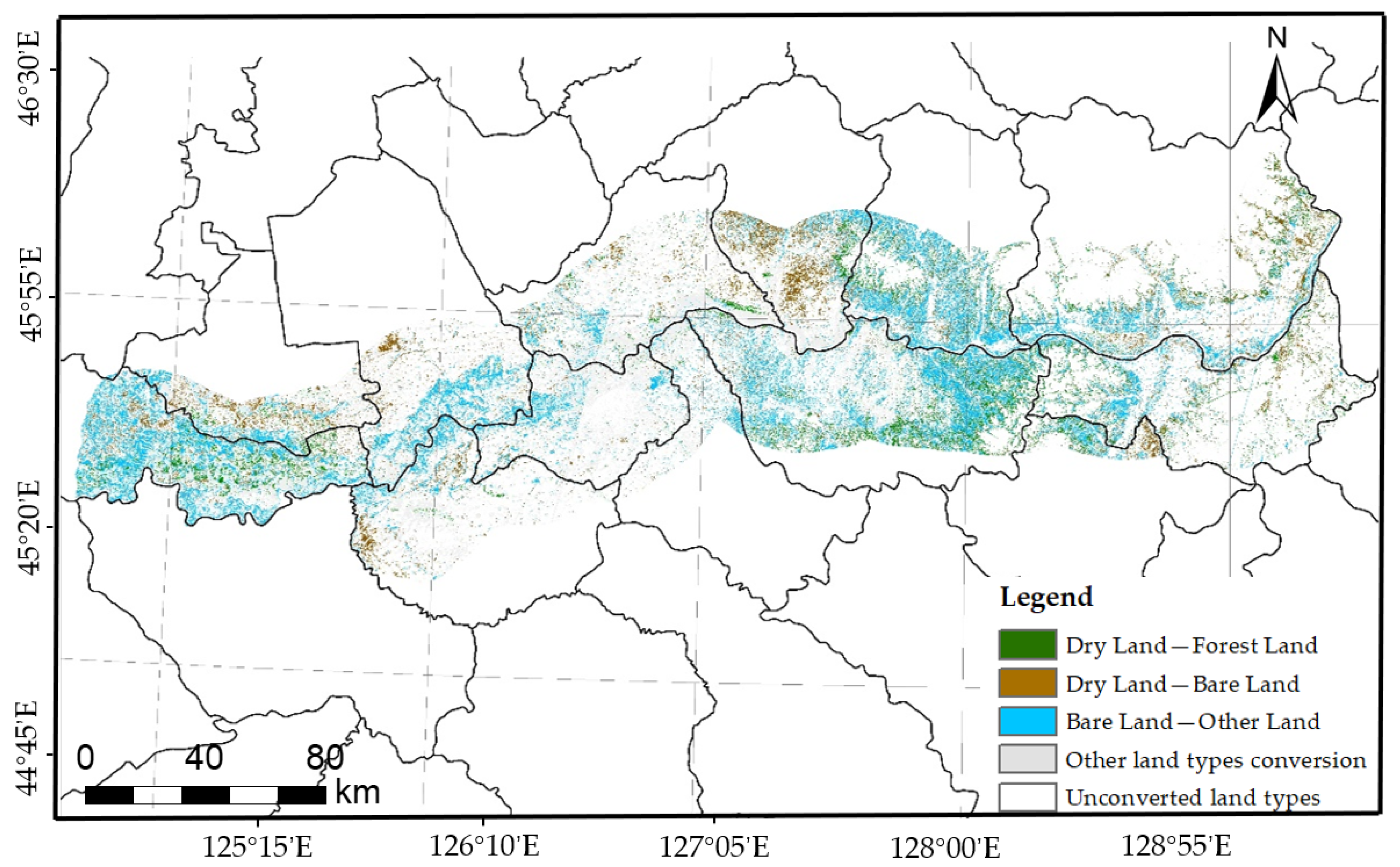
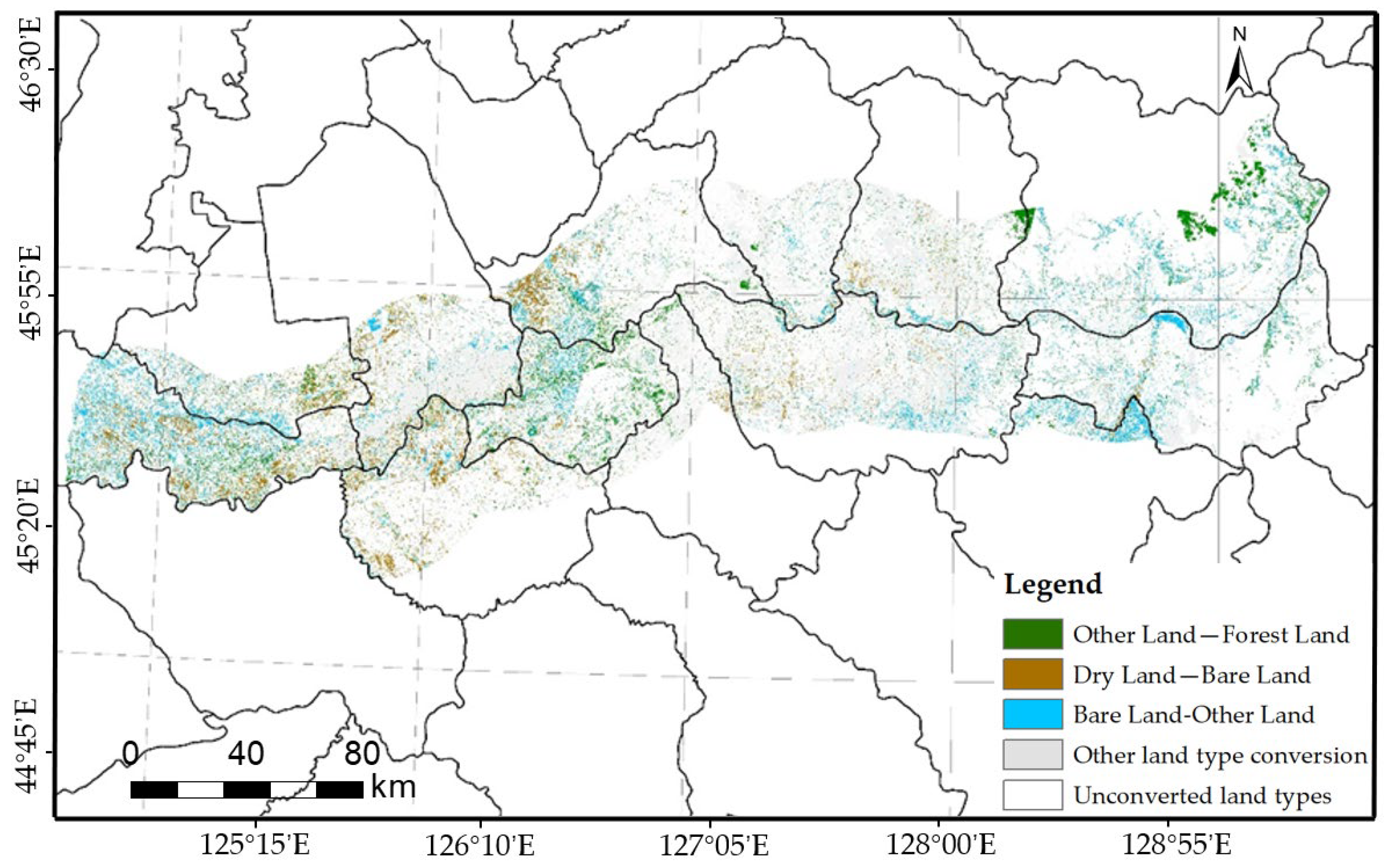
3.2. Analysis of Land Use Evolution in River Basin
3.2.1. Analysis of Land Use Area Change
3.2.2. Analysis on Spatial Transfer of Land Use Types
3.2.3. Analysis on Driving Factors of Land Use Change
- (1)
- Natural driving factors
- (2)
- Socio-economic driving factors
3.3. Risk Assessment Results and Analysis
3.3.1. Results of the SPCA
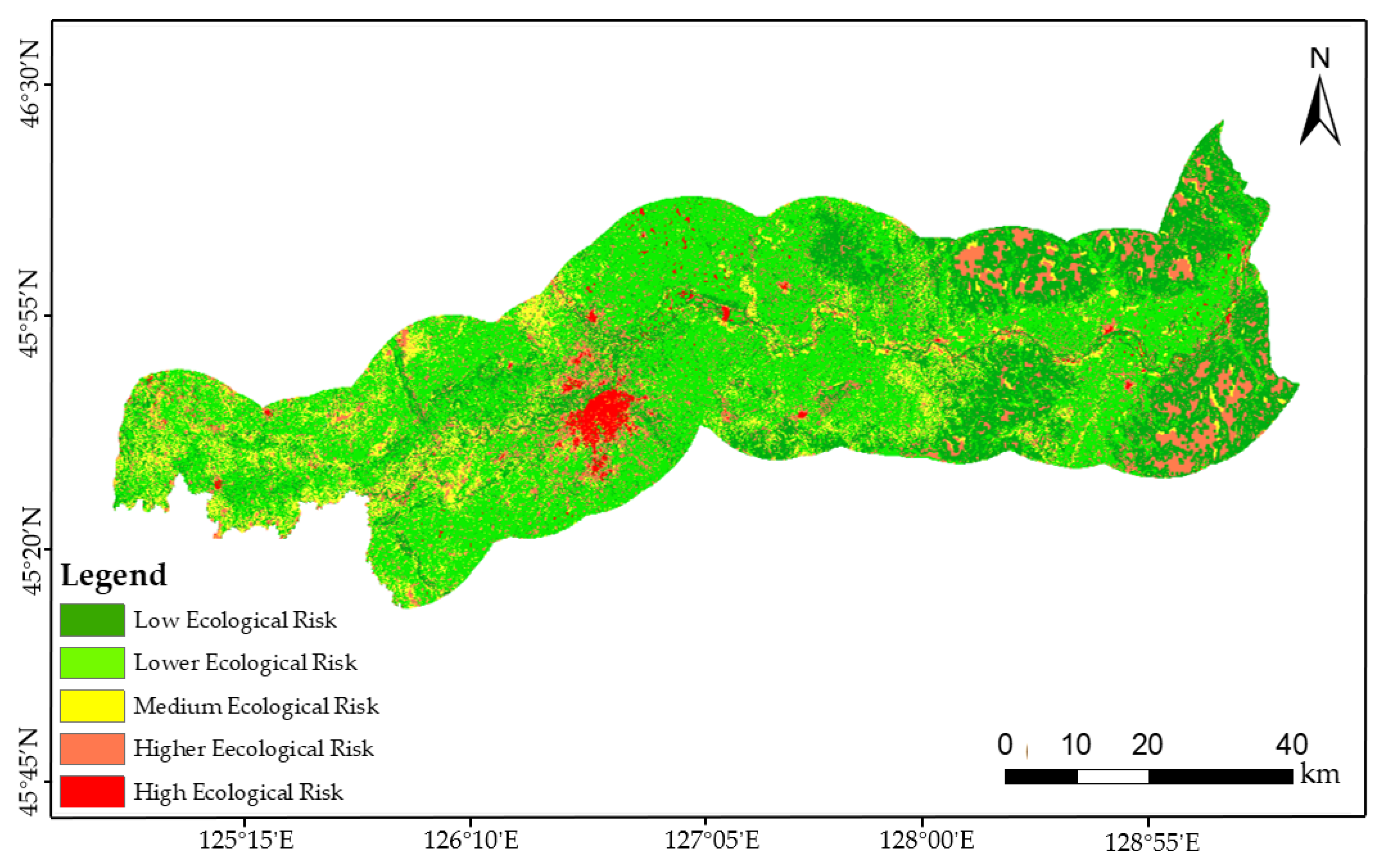
3.3.2. Ecological Risk Assessment of The River Basin Landscape
- (1)
- Regional assessment of low ecological risk level
- (2)
- Regional assessment of medium-low ecological risk level
- (3)
- Regional assessment of medium ecological risk level
- (4)
- Regional assessment of medium-high ecological risk level
- (5)
- Regional assessment of high ecological risk level
3.4. Ecological Protection and Planning Enlightenment
4. Conclusions
- (1)
- The application of study on driving factors of land use change complements the deficiency of the application of unstructured image data in the ecological environment. At the same time, it can better promote the application of big data technology in the field of the ecological environment and make up for the shortcomings of existing research.
- (2)
- The evaluation system of multi-source data fusion can improve the accuracy and comprehensiveness of landscape ecological risk assessment results and provide an effective basis for watershed ecological protection and planning. At the same time, the integration of multi-source data can better promote the application of big data technology in the field of ecological environment and make up for the deficiencies of existing research. In the landscape ecological risk assessment, multi-source data were fused, and the landscape pattern index data extracted from remote sensing images were used. The influences of natural and social factors on the landscape ecological risk were comprehensively considered, a three-dimensional comprehensive index system of nine influencing factors of the natural, social and landscape pattern was constructed, and the SPCA method was used to evaluate the landscape ecological risk in the study area comprehensively.
- (3)
- The landscape ecological risk assessment method based on spatial principal component analysis (SPCA) is effective and has good replicability of applications in other regions. The comprehensive landscape ecological risk assessment results were obtained by a weighted superposition of five principal component scores. The results showed that the overall risk index value of the buffer zone was between 0.166 and 0.838. The results were divided into five levels by the Natural Breaks method: low ecological risk, medium-low ecological risk, medium ecological risk, medium-high ecological risk, and high ecological risk. In this study, the spatial distribution characteristics of each ecological risk area and the characteristics of each index were analyzed and evaluated, providing basic information for mining the influencing factors of environmental ecological risk.
- (4)
- In future research, based on the results of landscape ecological risk assessment and the characteristics of risk sources in each risk level area, the ecological protection and planning enlightenment suitable for each risk level area can be obtained effectively. Thus, future research can provide ideas and evidence for environmental managers to formulate ecological risk protection countermeasures and reduce the impact of ecological risk threat factors.
Author Contributions
Funding
Data Availability Statement
Conflicts of Interest
References
- Zhou, S. Study on the Evaluation and Forewarning of Wetland Landscape Ecological Security for the Col Resource-Based Cities Based on Scenario Simulation. Ph.D. Thesis, China University of Mining and Technology, Xuzhou, China, 2020. [Google Scholar]
- Yang, M. Current Situation of Prevention and Control of Water Pollution in Songhua River Basin in Jinlin Province. Master’s Thesis, Jilin University, Changchun, China, 2019. [Google Scholar]
- Peng, J.; Dang, W.; Liu, Y.; Zong, M.; Hu, X. Review on landscape ecological risk assessment. Acta Geogr. Sin. 2015, 70, 664–677. [Google Scholar] [CrossRef]
- Sun, R.; Sun, L.; Su, X.; Chen, L. Study on the coupling of landscape pattern and ecological process: Inheritance and innovation. Acta Ecol. Sin. 2021, 41, 415–421. [Google Scholar]
- Liu, Q. Development history and future research focus of landscape ecology in China. Hous. Real Estate 2018, 19, 82. [Google Scholar]
- Mansourian, S. From landscape ecology to forest landscape restoration. Landsc. Ecol. 2021, 36, 2443–2452. [Google Scholar] [CrossRef]
- Hersperger, A.M.; Gradinaru, S.R.; Daunt, A.B.P.; Imhof, C.S.; Fan, P.L. Landscape ecological concepts in planning: Review of recent developments. Landsc. Ecol. 2021, 36, 2329–2345. [Google Scholar] [CrossRef]
- Chi, Y.; Zhang, Z.W.; Gao, J.H.; Xie, Z.L.; Zhao, M.W.; Wang, E.K. Evaluating landscape ecological sensitivity of an estuarine island based on landscape pattern across temporal and spatial scales. Ecol. Indic. 2019, 101, 221–237. [Google Scholar] [CrossRef]
- Kang, P.; Chen, W.P.; Hou, Y.; Li, Y.Z. Linking ecosystem services and ecosystem health to ecological risk assessment: A case study of the Beijing-Tianjin-Hebei urban agglomeration. Sci. Total Environ. 2018, 636, 1442–1454. [Google Scholar] [CrossRef]
- Chen, D.; Chen, Z.; Peng, B. Spatial differentiation and coupling effect between land ecosystem services value and economic development: A case study of West Dongting Lake area. Geogr. Res. 2018, 37, 1692–1703. [Google Scholar]
- Xie, L. Land Use Change and Landscape Ecological Risk Assessment of Ecological Function Zone in the Upper Yellow River. Master’s Thesis, Northwest Normal University, Lanzhou, China, 2021. [Google Scholar]
- Li, S.C.; Xiao, W.; Zhao, Y.L.; Lv, X.J. Incorporating ecological risk index in the multi-process MCRE model to optimize the ecological security pattern in a semi-arid area with intensive coal mining: A case study in northern China. J. Clean. Prod. 2020, 247, 119143. [Google Scholar] [CrossRef]
- Jin, X.; Jin, Y.X.; Mao, X.F. Ecological risk assessment of cities on the Tibetan Plateau based on land use/land cover changes—Case study of Delingha City. Ecol. Indic. 2019, 101, 185–191. [Google Scholar] [CrossRef]
- Darvishi, A.; Yousefi, M.; Marull, J. Modelling landscape ecological assessments of land use and cover change scenarios. Application to the Bojnourd Metropolitan Area (NE Iran). Land Use Policy 2020, 99, 105098. [Google Scholar] [CrossRef]
- Arfaeinia, H.; Dobaradaran, S.; Moradi, M.; Pasalari, H.; Mehrizi, E.A.; Taghizadeh, F.; Esmaili, A.; Ansarizadeh, M. The effect of land use configurations on concentration, spatial distribution, and ecological risk of heavy metals in coastal sediments of northern part along the Persian Gulf. Sci. Total Environ. 2019, 653, 783–791. [Google Scholar] [CrossRef]
- Wei, X. Landscape Ecological Risk Study of Shiyang River Basin Based on GIS and RS Approach. Master’s Thesis, Northwest Normal University, Lanzhou, China, 2016. [Google Scholar]
- Wang, B.B.; Ding, M.J.; Li, S.C.; Liu, L.S.; Ai, J.H. Assessment of landscape ecological risk for a cross-border basin: A case study of the Koshi River Basin, central Himalayas. Ecol. Indic. 2020, 117, 106621. [Google Scholar] [CrossRef]
- Zhang, X.; Dong, T.; Du, H.; Yuan, C.; Liao, C.; Wang, F. Analysis on spatial heterogeneity of landscape ecological risk in Fujiang River Basin. Res. Soil Water Conserv. 2022, 29, 156–163. [Google Scholar] [CrossRef]
- Zhang, Y.; Qu, J.; Ye, M. Landscape ecological risk assessment of Harbin section of Songhua River basin. J. Fuzhou Univ. (Nat. Sci. Ed.) 2020, 48, 361–367. [Google Scholar]
- Kang, Z.; Zhang, Z.; Wei, H.; Liu, L.; Ning, S.; Zhao, G.; Wang, T.; Tian, H. Landscape ecological risk assessment in Manas River Basin based on land use chang. Acta Ecol. Sin. 2020, 40, 6472–6485. [Google Scholar]
- Zhang, X.M.; Du, H.M.; Wang, Y.; Chen, Y.; Ma, L.; Dong, T.X. Watershed landscape ecological risk assessment and landscape pattern optimization: Take Fujiang River Basin as an example. Hum. Ecol. Risk Assess. 2021, 27, 2254–2276. [Google Scholar] [CrossRef]
- Xu, W.X.; Wang, J.M.; Zhang, M.; Li, S.J. Construction of landscape ecological network based on landscape ecological risk assessment in a large-scale opencast coal mine area. J. Clean. Prod. 2021, 286, 125523. [Google Scholar] [CrossRef]
- Cao, Q.W.; Zhang, X.W.; Lei, D.M.; Guo, L.Y.; Sun, X.H.; Kong, F.E.; Wu, J.S. Multi-scenario simulation of landscape ecological risk probability to facilitate different decision-making preferences. J. Clean. Prod. 2019, 227, 325–335. [Google Scholar] [CrossRef]
- He, Y.; Gong, Z.; Lin, K. Simulation of fine spatial distribution of regional future population based on geographical big data and multisource fused method: A case of the Pearl River Delta. Sci. Total Environ. 2022, 42, 426–435. [Google Scholar] [CrossRef]
- Liu, W.; Zhang, C.; Yu, B.; Li, Y.; Assoc Comp, M. A General Multi-Source Data Fusion Framework. In Proceedings of the 11th International Conference on Machine Learning and Computing (ICMLC), Zhuhai, China, 22–24 February 2019; pp. 285–289. [Google Scholar]
- Qian, W.; Yu, S.; Yang, J.; Wang, Y.; Zhang, J. Multi-label feature selection based on information entropy fusion in multi-source decision system. Evol. Intell. 2020, 13, 255–268. [Google Scholar] [CrossRef]
- Zhang, X.; Zhao, Y.; Guo, L. Aquatic ecological functional zoning of Songhua River Basin based on data fusion technology. J. Harbin Inst. Technol. 2019, 51, 80–87. [Google Scholar]
- Lepczyk, C.A.; Wedding, L.M.; Asner, G.P.; Pittman, S.J.; Goulden, T.; Linderman, M.A.; Gang, J.; Wright, R. Advancing Landscape and Seascape Ecology from a 2D to a 3D Science. Bioscience 2021, 71, 596–608. [Google Scholar] [CrossRef]
- Marvin, D.C.; Koh, L.P.; Lynam, A.J.; Wich, S.; Davies, A.B.; Krishnamurthy, R.; Stokes, E.; Starkey, R.; Asner, G.P. Integrating technologies for scalable ecology and conservation. Glob. Ecol. Conserv. 2016, 7, 262–275. [Google Scholar] [CrossRef] [Green Version]
- Nitoslawski, S.A.; Wong-Stevens, K.; Steenberg, J.W.N.; Witherspoon, K.; Nesbitt, L.; Konijnendijk van den Bosch, C.C. The Digital Forest: Mapping a Decade of Knowledge on Technological Applications for Forest Ecosystems. Earths Future 2021, 9, e2021EF002123. [Google Scholar] [CrossRef]
- Ge, X.; Yang, Y.; Peng, L.; Chen, L.; Li, W.; Zhang, W.; Chen, J. Spatio-Temporal Knowledge Graph Based Forest Fire Prediction with Multi Source Heterogeneous Data. Remote Sens. 2022, 14, 3496. [Google Scholar] [CrossRef]
- Sun, H.; Dang, Y.; Mao, W. A Decision-Making Method with Grey Multi-Source Heterogeneous Data and Its Application in Green Supplier Selection. Int. J. Environ. Res. Public Health 2018, 15, 446. [Google Scholar] [CrossRef] [Green Version]
- Ju, H.; Zuo, L.; Zhang, Z.; Zhao, X.; Wang, X.; Wen, Q.; Liu, F.; Xu, J.; Lin, B.; Yi, L.; et al. Methods research on describing the spatial pattern of land use types in China. Acta Geogr. Sin. 2020, 75, 143–159. [Google Scholar]
- Liu, T. Evolution and prospect of land use classification system in China. Urban. Archit. 2020, 17, 38–39+42. [Google Scholar] [CrossRef]
- Montano, V.; Jombart, T. An Eigenvalue test for spatial principal component analysis. BMC Bioinform. 2017, 18, 562. [Google Scholar] [CrossRef] [Green Version]
- Rahman, M.R.; Shi, Z.H.; Cai, C.; Zhu, D. Assessing soil erosion hazard—A raster based GIS approach with spatial principal component analysis (SPCA). Earth Sci. Inform. 2015, 8, 853–865. [Google Scholar] [CrossRef]
- Takane, S. Effect of domain selection for compact representation of spatial variation of Head-Related Transfer Function in all directions based on Spatial Principal Components Analysis. Appl. Acoust. 2016, 101, 64–77. [Google Scholar] [CrossRef]
- Li, Q.; Zhang, Z.; Wan, L.; Yang, C.; Zhang, J.; Ye, C.; Chen, Y. Landscape pattern optimization in Ningjiang River based on landscape ecological risk assessment. Acta Geogr. Sin. 2019, 74, 1420–1437. [Google Scholar]
- Ding, Y. Statistical Analysis; Publishing House of Electronics Industry: Beijing, China, 2019; p. 240. [Google Scholar]


| Number | Land Use Type | Interpretation Sign | Image Display |
|---|---|---|---|
| 1 | Water | Its geometric boundary is clear and distinct, smooth. The color is dark blue. |  |
| 2 | Forest Land | It is mostly found in mountainous areas and has a clear trend. The color is dark green. |  |
| 3 | Dry Land | It has a regular and continuous distribution with different spectral characteristics and is smooth. The color is orange. |  |
| 4 | Bare Land | It is distributed at the top or bottom of the mountain, and its texture is rough. The color is brownish. |  |
| 5 | Built-up Land | It is planar in distribution, with a rough texture and distinct borders. The color is red. |  |
| 6 | Water Field | It is distributed near the river, lumpy. The color is light green. |  |
| 7 | Saline Land | It shows a planar distribution, distributed on the edge of the bare ground of the pond with obvious borders. The color is grayish-white. |  |
| Time | Overall Classification Accuracy (%) | Kappa Coefficient |
|---|---|---|
| 2005 | 85.73 | 0.8113 |
| 2006 | 80.65 | 0.7642 |
| 2007 | 79.81 | 0.7218 |
| 2008 | 82.94 | 0.8073 |
| 2009 | 76.18 | 0.7186 |
| 2010 | 82.25 | 0.7752 |
| 2011 | 82.47 | 0.7762 |
| 2012 | 84.33 | 0.8013 |
| 2013 | 85.40 | 0.8065 |
| 2014 | 83.80 | 0.7916 |
| 2015 | 80.33 | 0.7592 |
| 2016 | 75.28 | 0.7122 |
| 2017 | 83.21 | 0.7863 |
| 2018 | 79.84 | 0.7546 |
| Principal Component | Eigenvalues | Contribution Rates | Cumulative Contribution Rates |
|---|---|---|---|
| pc1 | 3.451 | 41.7% | 41.7% |
| pc2 | 2.846 | 26.7% | 68.4% |
| pc3 | 2.152 | 10.1% | 78.5% |
| pc4 | 1.617 | 8.1% | 86.6% |
| pc5 | 1.359 | 5.8% | 92.4% |
| Comprehensive Evaluation Factors | Original Index | pc1 | pc2 | pc3 | pc4 | pc5 |
|---|---|---|---|---|---|---|
| Landscape pattern factors | Land use types | 0.792 | 0.567 | 0.111 | 0.185 | 0.024 |
| SHDI | 0.496 | 0.526 | 0.099 | 0.555 | 0.305 | |
| CONTAG | 0.297 | 0.627 | 0.263 | 0.588 | 0.191 | |
| NDVI | 0.126 | 0.075 | 0.718 | 0.100 | 0.604 | |
| Social factors | Population density | 0.031 | 0.020 | 0.136 | 0.368 | 0.003 |
| GDP per unit area | 0.107 | 0.089 | 0.112 | 0.097 | 0.045 | |
| Natural factors | Soil types | 0.125 | 0.042 | 0.068 | 0.416 | 0.316 |
| Soil texture | 0.009 | 0.006 | 0.600 | 0.313 | 0.635 | |
| Elevation | 0.081 | 0.021 | 0.098 | 0.144 | 0.046 |
Publisher’s Note: MDPI stays neutral with regard to jurisdictional claims in published maps and institutional affiliations. |
© 2022 by the authors. Licensee MDPI, Basel, Switzerland. This article is an open access article distributed under the terms and conditions of the Creative Commons Attribution (CC BY) license (https://creativecommons.org/licenses/by/4.0/).
Share and Cite
Zhao, Y.; Tao, Z.; Wang, M.; Chen, Y.; Wu, R.; Guo, L. Landscape Ecological Risk Assessment and Planning Enlightenment of Songhua River Basin Based on Multi-Source Heterogeneous Data Fusion. Water 2022, 14, 4060. https://doi.org/10.3390/w14244060
Zhao Y, Tao Z, Wang M, Chen Y, Wu R, Guo L. Landscape Ecological Risk Assessment and Planning Enlightenment of Songhua River Basin Based on Multi-Source Heterogeneous Data Fusion. Water. 2022; 14(24):4060. https://doi.org/10.3390/w14244060
Chicago/Turabian StyleZhao, Ying, Zhe Tao, Mengnan Wang, Yuanhua Chen, Rui Wu, and Liang Guo. 2022. "Landscape Ecological Risk Assessment and Planning Enlightenment of Songhua River Basin Based on Multi-Source Heterogeneous Data Fusion" Water 14, no. 24: 4060. https://doi.org/10.3390/w14244060


