Article

Compatibility between Continental Shelf Deposits and Sediments of Adjacent Beaches along Western Sardinia (Mediterranean Sea)

by
Giovanni De Falco
1,
Simone Simeone
1,*,
Alessandro Conforti
1,
Walter Brambilla
1 and
Emanuela Molinaroli
1,2
1
CNR—IAS Istituto per lo Studio Degli Impatti Antropici e Sostenibilità in Ambiente Marino, 00146 Rome, Italy
2
Department of Environmental Sciences, Informatics and Statistics, University Ca’ Foscari of Venice, Via Torino 155, 30170 Venezia, Italy
*
Author to whom correspondence should be addressed.
Water 2022, 14(23), 3971; https://doi.org/10.3390/w14233971
Submission received: 16 November 2022 / Revised: 30 November 2022 / Accepted: 2 December 2022 / Published: 6 December 2022

Abstract

:
The compatibility of sediments in terms of grain size, composition and colour among beaches and strategic sediment deposits (SSD) along Western Sardinia (Western Mediterranean Sea) were assessed to explore management strategy in the protection and adaptation to counteract the beach erosion and the effect of sea level rise along sandy shores. Twelve beaches, mainly conditioned by geological control, due to the presence of extensive rocky outcrops in the sea, enclosed in seven sedimentary cells (defined by the continuity of sediment transport pathways and by identification of boundaries where there are discontinuities), were characterised in terms of sediment composition and grain size. One hundred ninety-three beach sediments and one hundred sediments from SSDs were collected and analysed for sediment grain size, carbonate content and sediment colour. The beach sediments are composed by gravel to fine sands (D50: from 81 µm to 4986 µm) with siliciclastic and biogenic carbonate sediments mixed in different proportions (0–100% in CaCO3). The SSDs sediments are gravels to medium-fine sand (D50: from 96 µm to 1769 µm) composed by biogenic carbonate sands mixed with siliciclastic grains (0–100% in CaCO3). To be able to evaluate the compatibility between the beaches and SSDs, a multivariate statistical procedure was applied to grain size dataset. Our results show that 8 beaches have strategic deposits of compatible grain size and composition, whereas only 2 beaches have compatible strategic deposits of both grain size and colour. This may be related to the different sediment sources and depositional processes of sediment along the coastal cells and the continental shelf.

1. Introduction

Beach and barriers are complex systems that characterize about the 30% of the ice-free world shorelines [1]. They protect the landward areas from flooding and storms, they host precious ecosystems and can provide important income for recreational tourism economy [2,3]. Recent studies indicate that over a period of 33 years (1984–2016), 24% of the world’s sandy beaches were eroded at rates exceeding 0.5 m yr−1, while 28% were accreted and 48% were stable. On a global scale, the overall surface of eroded land is about 28,000 km2, twice the surface of gained land in the same period [1,4].
Over a long-term perspective, the climate change can be considered the most important forcing that would have an impact on the coastal area. Thousands of kilometres of the world’s sandy beaches could face severe erosion by the end of the century and millions of coastal inhabitants would be forced to move [5,6].
Among the climate change drivers, storms and sea level rise (SLR) are the most relevant from coastal hazard perspective [7]. In the Mediterranean Sea storminess is not expected to increase [8,9], instead the SLR can be one of the main forcing which will influence the coastal areas and in particular the coastal plains, including beach and barriers [6,10,11,12]. The SLR may imply a redistribution of the sediments of the coastal system leading to a shoreline retreat and a change on sediment budget of the littoral cells that can promote a reorganisation of the configuration of the coast [13]. A further factor which may influence the sediment budget of carbonate beaches is ocean acidification, both by affecting the ecosystems which provide biogenic sands and promoting dissolution of carbonates [14].
The prediction of beach evolution following climate change is of particular importance to develop long-term strategic adaptation plans [15]. The adaptation of coastal systems refers to an adjustment in natural or human systems as a means of moderating the adverse impacts and includes three basic approaches: (1) protect, (2) accommodate and (3) retreat [15,16]. The ‘accommodate’ option involves the continued occupancy and use of vulnerable zones by increasing the ability to cope with the effects of extreme events, also providing space for coastal processes [16,17]. In some case it could be possible to shift inland the artefacts which limits the accommodation space applying the ‘retreat’ option.
The soft protection of beaches is generally performed by sand nourishment, and this approach includes the availability of strategic sediment deposits (SDDs). The SSDs are supplies of sediment of appropriate characteristics that are available for replenishment of the coastal zone, either temporarily or in the long term [18]. Due to their importance SSDs have been mapped along the Mediterranean continental shelves to include the availability of sand in beach management plans [19,20,21,22].
A further aspect to be considered in sediment management plans is the compatibility between the materials of SSDs over the continental shelf and the sediments of the beaches facing the adjacent coastal sectors. Particularly, beach sediments of coastal areas characterised by high geomorphological variability may derive from multiple sources (small rivers, cliff erosion, coastal ecosystems) thus resulting extremely variable in grain size and composition [23,24,25]. The availability of compatible sediments is a key factor to implement the adaptation strategies of coastal systems with respect to long term scenarios related to the global change.
This study provides a new approach based on multivariate statistics apply to grain size dataset to assess the compatibility between the sediments of a large marine sand deposit over the continental shelf and the sediments of adjacent beaches. Then, results of the multivariate were used to point out the chromatic compatibility between the sets of samples. The study examined a coastal sector of the Western Sardinia (Western Mediterranean Sea), 100 km long, with 12 beaches partially geologically constrained [26], composed by various sediment types forming several coastal cells. The specific aim is to highlight a new approach to assess, for each coastal cell, the availability of compatible sediments from the sand deposits located in the continental shelf. In the future, this new approach might be applied to other beaches mainly conditioned by geological control.

2. Study Area

The study area is the coastal sector of the Central Western Sardinia Island (Western Mediterranean Sea) and extends from the Sinis Peninsula to the Gulf of Oristano (Figure 1). The Sinis Peninsula is a structural high, formed by a sequence of volcanic and sedimentary rocks (marls, sandstone, and limestone), dating from the Neogene to the Quaternary [27]. The Gulf of Oristano is bordered to the west by rocky capes and has a mostly sandy shoreline which also includes several marshes and lagoons. The Tirso River is the major source of terrigenous sediments [28], the mouth of which is in the north-eastern part of the Gulf (Figure 1). The geological setting of the basin draining into the gulf includes Palaeozoic crystalline basement, Oligocene-lower Miocene calco-alkaline volcanic formations, Miocene and Pliocene sedimentary formations and Pliocene and Quaternary basaltic deposits.
The continental shelf is sediment-starved, with limited land-to-sea sedimentary run-off. The absence of sediment run-off allowed the colonisation of the seabed by extended Posidonia oceanica seagrass meadows (Figure 1). The transgressive deposits associated with the last post-glacial sea level rise are characterised by siliciclastic sands and calcareous bioclastic sands [29,30,31,32,33] along the inner shelf, as well as clays and calcareous mud along the outer shelf [34]. Along this area, several submerged sand deposits, from 25 to 140 m depth, were detected and characterised in terms of grain size, stratigraphy, composition, and available volume [22,30,31].
The Sinis Peninsula is partially included in a Marine Protected Area (MPA Penisola del Sinis and Isola di Mal di Ventre) and is characterised by a low degree of urbanizations, except for two small villages mainly occupied during summer season. Local hotspots of coastal erosion were highlighted in two beaches (Is Arutas, Su Pallosu, [35]). The shore of the Gulf of Oristano is characterised by the presence of a commercial port, two touristic marinas, a small village developed on the backshore along the northern side of the Gulf, cross-shore dikes and artificial lagoon inlets. The inland drainage system was modified during the last 100 years; a large part of the wetlands was reclaimed, and large dune fields were smoothed for agriculture and residential purposes.
The Gulf of Oristano is considered vulnerable with respect to sea level rise due to the low elevation of the Campidano plane [10,36].
Despite that some beaches of the studied area showed a shoreline retreat [35] no nourishment project was realised in the investigated area. Considering the Island of Sardinia two nourishments were realised in the last 40 years [37]. The first was fulfilled in Cala Gonone by using residual grains and cobbles from a limestone quarry and involved about 80,000 m3; the second, more important was realised in Poetto Beach. In this nourishment ~ 400,000 m3 of material was dredged from a depth of ~40 m and used to nourish the beach.

3. Materials and Methods

3.1. Sedimentological Data Set

A total 98 sediment samples were collected from 8 beaches (1, 2, 3, 4, 5, 10, 11, and 12, Figure 1 and Table 1) by using PVC pipes (10 cm length, 5 cm diameter) along transects normal to the shoreline in the backshore, foreshore, upper offshore. These samples were integrated with sediment data collected in previous studies in the remanent 4 beaches (6, 7, 8, and 9, Figure 1 and Table 1; [14,23,33]) to obtain a dataset composed by a total of 193 sediment samples. The whole dataset was processed in this study.
Sediment samples along the continental shelf were collected during the years 2007–2013 for a total of 100 samples and sediment data were already published in previous studies [30,31,32]. Table S1 (see Supplementary Materials) report the whole sedimentological data set for a total of 293 sediment samples.
All samples were processed with the same methodologies in the CNR-IAS laboratory. Specifically, gravelly sandy sediments were carefully washed to remove salt, and grain size distribution was measured using dry sieving for the gravel/sand fraction between >4000 and 90 μm at half-phi intervals; the finer fraction (<90 μm) was analysed using a Galai CIS 1 laser system at 0.5 μm intervals [42]. Statistical parameters of grain size data distributions were computed using the momentum method using the GRADISTAT spreadsheet [43]. The carbonate fraction of sediments is of biogenic origin [23,33]. The carbonate contents of both sets of sediments samples were determined by using the Dietrich-Fruhling calcimeter. The samples were classified into three groups based on biogenic carbonate contents: siliciclastic (carbonate 0–20%), mixed (20–60%) and biogenic carbonate (60–100%).
Sediment colour assessment was determined by the matching of each sediment sample with the closest Munsell Soil Colour Charts. The Munsell system is easy to use and respects the progressiveness with which we perceive colour differences. What is difficult is to measure these differences that are essential for expressing them objectively. The California Coastal Commission [44] refers to it for determining the colour of native and nourishment sands. The precision with which a colour can be visually characterised with the Munsell system is estimated at 0.5 Hue, 0.1 Value, and 0.4 Chroma (ASTM D1535) [45]. A more objective method to determine the compatibility between borrow and natural sediments is reported in [46] and [47]. In these studies, the CIEL*a*b* colour space appears to be the most reliable method and allows an exact quantification of the chromatic distance between two samples.

3.2. Littoral Cells

A littoral cell is a coastal compartment that contains a complete cycle of sedimentation including sources, transport paths, and sinks [48]. Cells and sub-cells can be defined examining the continuity of sediment transport pathways and by the identification of boundaries where discontinuity occurs [49]. Along urbanised areas the man-made boundaries can further separate a cell into sub-cells [50]. In this study the littoral cells were identified considering the longshore sediment transport direction, the presence of headlands causing discontinuity, and with the characterisation of the beach sediments [24].
The mean wave energy flux (MWEF) directions coupled with the main headlands position were considered in first instance to delimitate the boundaries of the littoral cells. This because the longshore sediment transport is correlated to the wave exposure and longshore component of wave power. The MWEF for the whole Western Sardinian coast was determined by Atzeni et al. [51], whereas a more detailed description of the MWEF for the northern sector of the investigated area was provided by Sulis et al. [52]. The MWEF is mainly related to storms forced by the Mistral wind (coming from the 0northwest) along the Western Sardinia coastal sector [51]. In correspondence of main headlands, the Mistral storms can promote opposite directions of the MWEF which can be used to establish the boundaries of the littoral cells [51,52].
Furthermore, the beach sediment grain size and composition were used to infer the sediment source [23,53,54], thus providing additional information which were used to delimit the littoral cells and sub-cells.

3.3. Multivariate Statistics

The grain size fractions of the beach sediment sample (Table S1) were subjected to Entropy-Max analysis (EM) [48,49,55,56,57]. The software is designed to ensure optimal grouping, maximising the inequality between groups of samples and minimising the inequality within the groups, so that the distributions in each group have similar shapes, and the shapes of the distributions differ mainly between groups [56]. EM allows optimal classification of samples into self-similar groups.
Discriminant analysis (DA) was applied to grain size data of both beach sediments and SSDs. With an “a priori” criterion, i.e., the results of the EM, DA is employed to group the SSDs in relation to the variables that have greater discriminating power. Data were previously transformed, by using the ranking method, to avoid artifacts due to the closure to 100 of grain size data [58].

3.4. Assessment of the Availability of SSDs

To assess the availability of SSDs grouped by the DA, a partitioning of the area in which the deposits are located was realised. A square grid of 4 km on each side was considered. Each square includes an area of 16 km2 which is equivalent to 1.6 107 m3 of available sediment, with at least 1 m of thickness. The minimum thickness of 1 m was measured through the analysis of seismic surveys previously performed in the study area [22]. A specific type of sediment was assigned to each square based on the number of samples falling inside and on their statistical classification. SSDs were considered available if at least 5 stations fell into the square. Moreover, the assignment of single square to a specific DA group was carried out when at least half of the samples fell into a single group.

4. Results

4.1. Beach Geomorphology and Littoral Cells

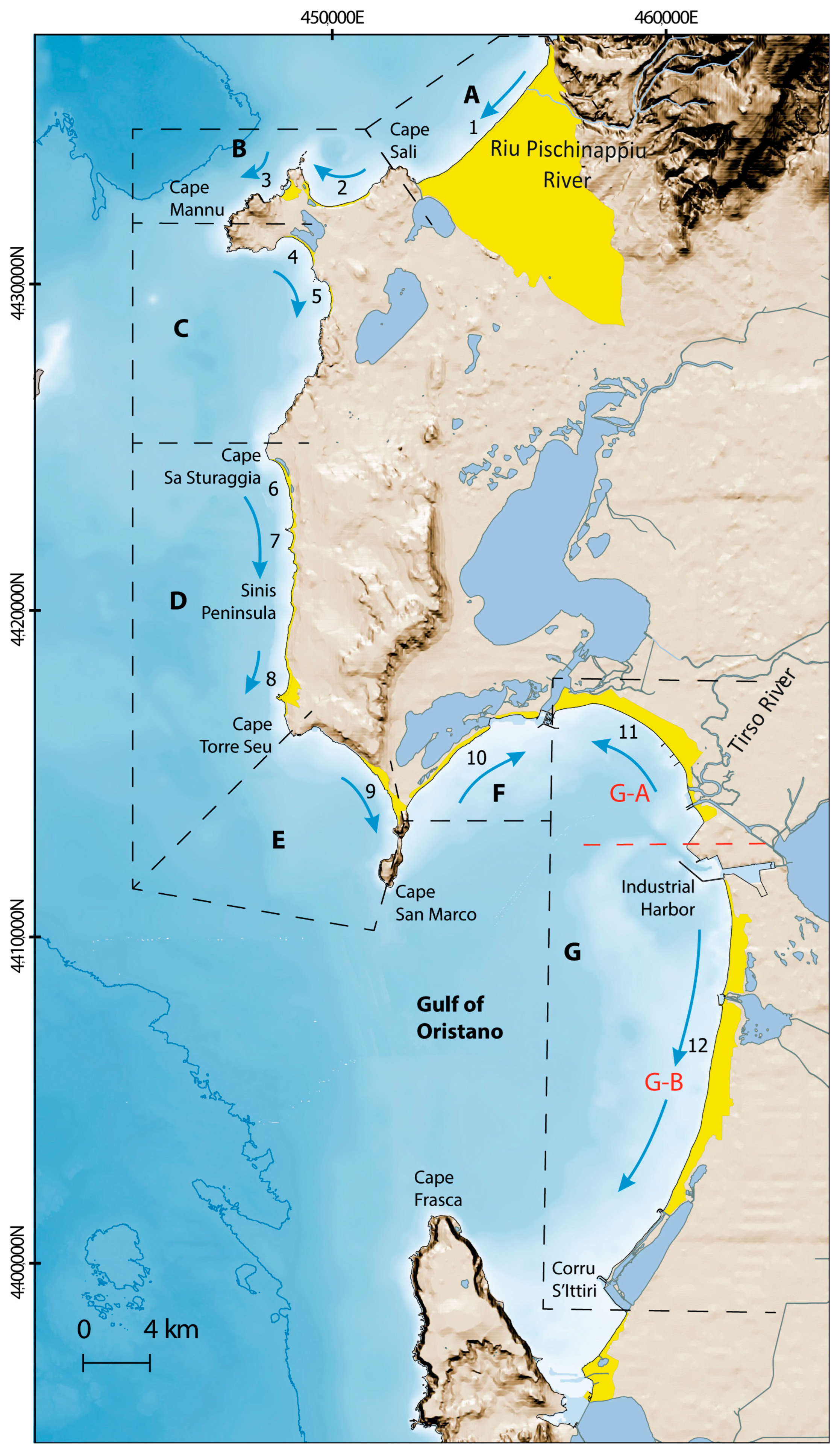
A total of 7 littoral cells were identified (Figure 2 and Table 1). Each cell is separated by the adjacent one by the opposite ways of the longshore directions of the mean wave energy flux (MWEF). The MWEF directions (as they were reported by [51,52]) were showed in Figure 2. The MWEF diverges in correspondence of three headlands: Cape Mannu, Cape Sa Sturaggia and Cape San Marco. The other headlands (Cape Sali and Cape Seu, Figure 2) and lagoon inlets separate beaches which were characterised by sediments with different composition (Table 1).
Cell A include Is Arenas beach, a large beach characterised by a wide dune field. The MWEF and the related longshore sediment transport directions are oriented from SW to NE. A small river flows into the northern sector of the beach (Figure 2). Sediments are mixed gravelly sands and origins from the reworking of riverine sediments and biogenic sediments derive from coastal ecosystems facing the beach (Table 1). Sediment colours are light yellowish and pale brown (Table 2).
Cell B extends from Cape Sali to Cape Mannu (Figure 2). The MWEF is oriented from west to east [52]. Two beaches are enclosed in this cell (Sa Rocca Tunda and Sa Mesa Longa, Table 1; numbers 2 and 3 in Figure 2). Beach sediments are mixed sands, with a predominant biogenic carbonate component: they derive from ecosystems production and cliff erosion, while there is not any contribution from rivers (Table 1). Colour of sediments for these beaches are light grey to pink (Table 2).
Cell C extends from Cape Mannu to Cape Sa Sturaggia and enclose two beaches (Putzu Idu and S’Arena Scoada, Table 1; numbers 4 and 5 in Figure 2). The MWEF is oriented to the south. Putzu Idu Beach is a barrier–lagoon system while S’Arena Scoada beach is bordered by a cliff. Sediments are medium-fine sands with a dominant siliciclastic component. Sediment colour is light grey and white (Table 2).
Cape Sa Sturaggia is the boundary among Cells C and D. The MWEF flux is oriented to the south [51]. Cell D enclosed three beaches. Mari Ermi (Table 1, number 6 in Figure 2) is a barrier–lagoon system, Is Arutas (Table 1, number 7 in Figure 2) is an embayed beach and Maimoni (Table 1, number 8 in Figure 2) is a barrier/beach–dune system. The sediment composition deriving from the mixing of coarse siliciclastic sediments and finer bioclastic sediments (Table 1, [23]). The siliciclastic component of the sediments is formed by gravels and coarse sands, the biogenic components is formed by medium-fine sands. Sediment colours are pinkish, grey, and white (Table 2).
Cell E is located between Cape Seu and Cape San Marco. The MWEF flux is oriented to the south [51]. The San Giovanni beach (Table 1, number 9 in Figure 2), located in this cell, is a semi-constrained beach and dune system [33,54]. Sediments of this cell are mainly sand and slightly gravelly sand and are characterised by the prevalence of bioclastic components deriving from ecosystem carbonate-producers ([33], Table 1). Sediment colours are pale brown and light brownish grey (Table 2).
Two cells can be identified inside the Gulf of Oristano (Figure 2). Cell F extends between Capo San Marco and the inlet of the Cabras lagoon. The beach of Su Siccu, located in cell F (Table 1, number 10 in Figure 2), is a barrier enclosing a wide lagoon and is composed by fine mixed siliciclastic and carbonate biogenic sands (Table 1). Sediment colours are light brownish grey and pale brown (Table 2).
The inlet of Cabras lagoon marks a drastic change of sediment composition, separating cells F and G. Cell G is the main cell of the Gulf of Oristano. The system is characterised by a wide beach, running for several km from the north to the south of the Gulf. The cell is interrupted by the industrial Port of Oristano that subdivide the main cell in two sub cells: Ga and Gb. The mouth of the Tirso river is part of the southern area of the cell Ga (Figure 2). The flux is from SE to NW in cell Ga, whereas in Gb is from north to south [51]. Sediments of this cell range from gravelly sand to sand, they are siliciclastic, with lack of mixed and carbonate sediments and originate from river supply and reworking of alluvial deposits (Table 1 [29]). Sediment colours are light grey, grey, and pale brown (Table 2).

4.2. SSDs vs. Beach Sediments

The grain size data and carbonate content of sediment collected over the SSDs located in the central western continental shelf of Sardinia are reported in Table S1 (Supplementary Materials). Multivariate statistical techniques were applied to classify beach and SSDs sediment samples into sedimentary facies to distinguish sample groups both from grain size and compositional characteristics. Different steps of data analysis were applied due to the mixing nature of the sediments (siliciclastic and carbonate).
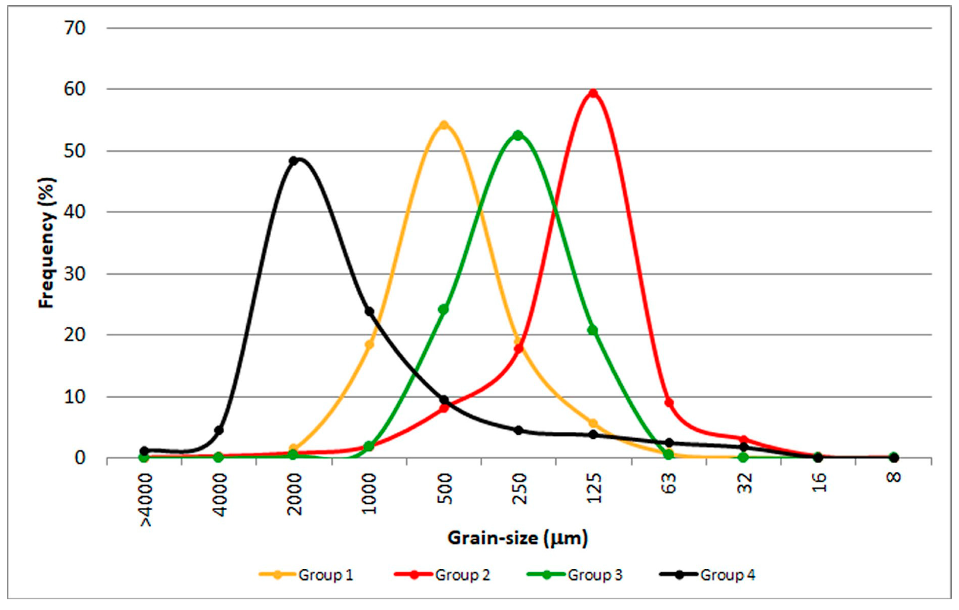
In order to better understand the role of grain size distributions rather than single grainsize intervals EM analysis was applied to the raw data of beach sediments samples (Figure 3). Eleven intervals per sample were used and the main result of this kind of statistical representation indicated the best grouping solution in four groups. The four groups of distributions resulting from the entropy analysis are displayed in Figure 3. The groups are numbered from 1 to 4, the standard deviation are 1.84 phi and 1.97 phi for groups 1 and 2, respectively; and 1.69 phi and 2.75 phi for groups 3 and 4. Skewness for groups 1 and 4 is negative (−0.54 and −1.70, respectively), whereas it is positive for groups 2 and 3 (0.82 and 0.34, respectively).
The grain size characteristics corresponding to the four groups are as follows: (1) a slightly gravelly sand, with a mode at 500 μm (coarse sand); (2) a slightly gravelly sand, with a sand mode 125 μm (from medium to fine sand); (3) as lightly gravelly sand, sandy gravel and sand with a mode at 250 μm (medium sand); (4) a gravel, sandy gravel and gravelly sand with a mode at 2000 μm (from very fine gravel to very coarse sand).
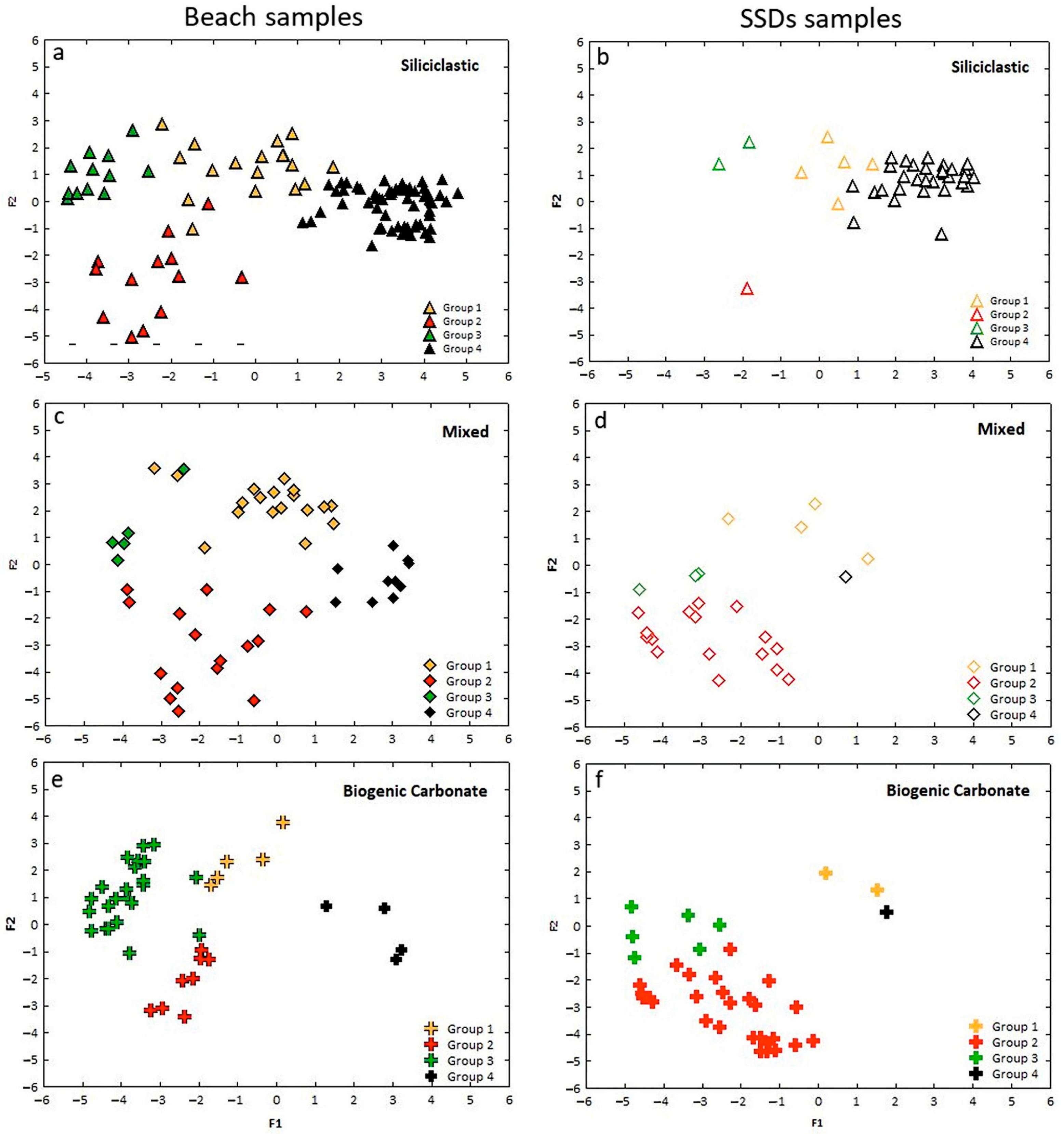
To evaluate the similarity between the grain size of beach sediments and the grain size of submerged sediment deposits (SSDs) a Discriminant analysis (DA) was applied to the 4 groups pre-defined by the EM and to the grain size data of SSDs. The SSDs were initially included as unknow samples; the DA is a statistical procedure able to classifies unknown samples and the probability of their classification into a certain group. The results of DA for the 293 samples are summarised in Figure 4, in which discriminant scores are scatter-plotted for the two discriminant functions.
Six variables significantly contributed to the separation between the groups and two Discriminant functions explain 96% of the total variance of the samples. Function 1 explained 73% of the total variance and Function 2 explained 23% of the total variance.
The grain size fractions with greater discriminating power were: (a) the very fine gravel, the very coarse and fine sand fractions (4000–2000, 2000–1000, and 250–125 μm) for function 1, separating especially groups 4 from 2 and 3 and slightly from group 1; (b) the medium, very fine sand and coarse silt (500–250, 125–63, and 63–32 μm) for function 2, which clearly separates group 2 (negative values) from groups 1, 3, and 4 (positive values). Table 3 summarises the results.
In Figure 4, together with the result of the DA, the biogenic carbonate content for each group of beaches and SSDs samples is also shown (Figure 4a–f). The siliciclastic (0–20% carbonate) sediments are mostly concentrated in group 4 both in beaches and SSDs samples with prevailing fine gravel and very coarse sands. Siliciclastic sediments are also present in beaches of groups 1, 2, and 3. Only few samples from the SSDs sediments are reached in siliciclastic components in groups 1, 2, and 3 (Figure 4a,b). The mixed (20–60% carbonate) carbonate/siliciclastic sediments in beach samples are scattered in groups 1 and 2 with prevailing medium and very fine sand few samples are accounted also in groups 3 and 4. Mixed sediments include several SSDs samples of group 2, while there are only few in groups 1, 3, and 4 (Figure 4c,d). The biogenic carbonate (60–100% carbonate) sediments are mainly present in beaches and SSDs sediment samples in groups 2 and 3 with prevailing the finer fractions, whereas there are few samples of both beaches and SSDs clustered in groups 1 and 4 with high biogenic carbonate contents (Figure 4e,f).
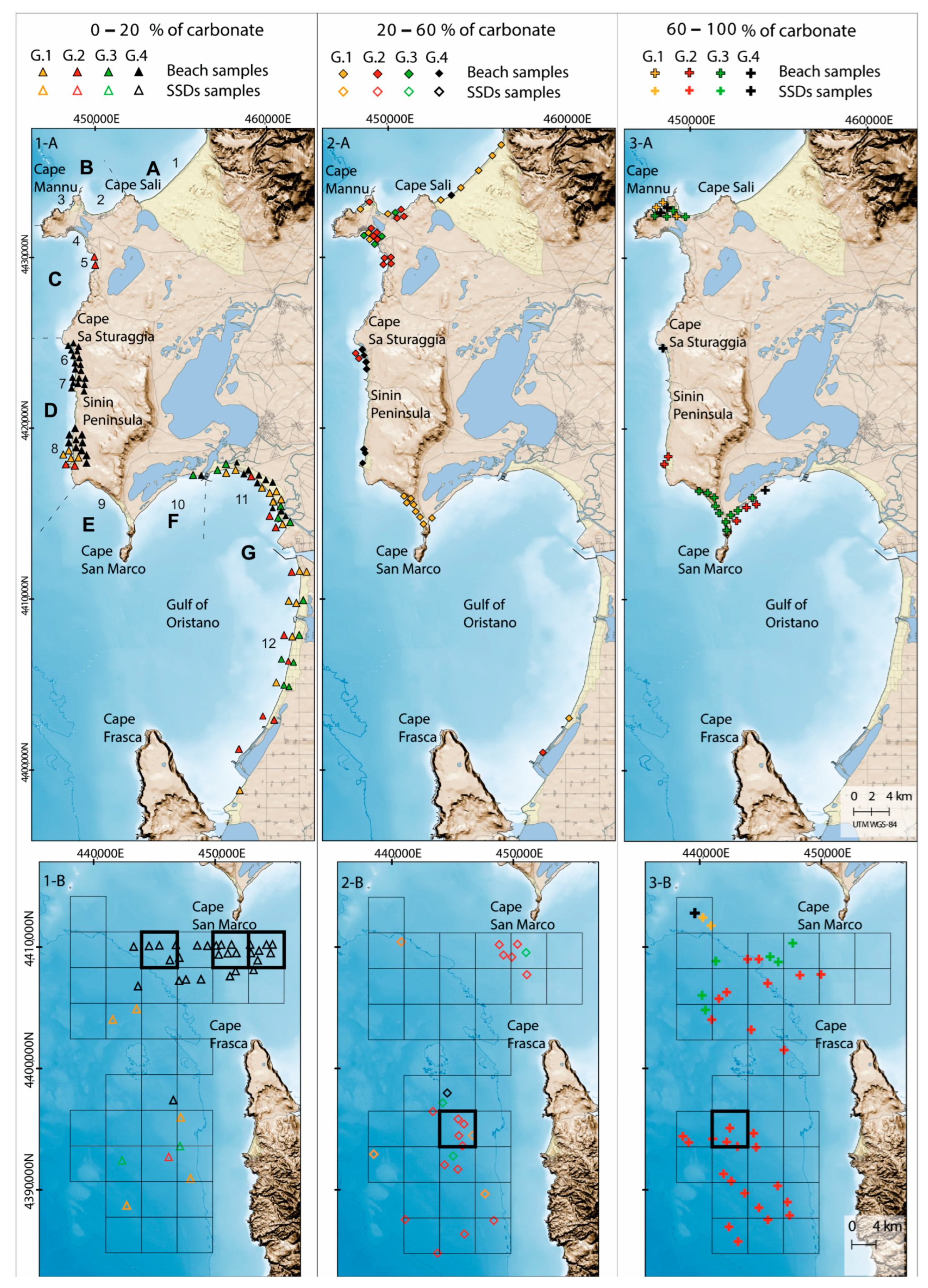
The compatibility analysis between beaches and SSDs sediments Is shown in Figure 5. The Figure 5 (Panels 1-A, 2-A, and 3-A) shows the location of the beach sediment samples split into 4 grain size groups identified by the multivariate statistical analysis (G1, G2, G3, and G4) and belonging to the three compositional groups based on the calcium carbonate content (siliciclastic: 0–20%, mixed: 20–60%, and biogenic carbonate: 60–100%). Figure 5 (Panels 1-B, 2-B, and 3-B) shows the location of the SDDs samples divided into the 4 grain size groups (G1, G2, G3, and G4) and their belonging to compositional groups described above. In Panels 1-B, 2-B, and 3-B, a grid of 4 km of side was superimposed to the map, and this was useful to assess the availability of SSDs to a specific group based on the number of samples falling inside each square of the grid (see Section 3 for the description of the criteria used).
The beaches characterised by siliciclastic sediments (0–20%) are mainly located in cells D, western sector of the Sinis Peninsula and G, Gulf of Oristano (Figure 5, Panel 1-A). Sediments of cell D fall predominantly in group G4 and partially in group G1 (sub-cell 8). Sediments of cell G are heterogeneous: all the four groups are present in sub-cell 11, while 3 groups (G1, G2, and G3) are present in sub-cell 12. The SSDs characterised by siliciclastic deposits fall almost exclusively in group G1 (Figure 5, Panel 1-B). Two squares grid (Figure 5, Panel 1-B) contain 5 stations belonging mainly to group G4. With regard to grain size and compositional compatibility, it was highlighted that beaches of cell D (sub-cells 6, 7, and 8) and one beach of cell G (sub-cell 11) have a deposit of sediment equivalent in size and composition located in the SDDs.
Beaches characterised by mixed sediments (20–60%) are mainly located in cells A, B, C, and E (Figure 2 and Figure 5, Panel 2-A) in the Sinis Peninsula. Some mixed sediment samples are also present in cell D. The mixed sediments of the beaches are quite heterogeneous and fall into the four groups (G1, G2, G3, and G4, Figure 5, Panel 2-A). The SSDs of mixed sediment fall almost exclusively in group G2 (square highlighted in Figure 5, Panel 2-B). One square grid (Figure 5, Panel 2-B) contains 5 stations belonging mainly to group G2. Concerning grain size and compositional compatibility, it was highlighted that sub-cells 2, 4, and 5 have an equivalent sediment in marine deposits, while sub-cells 1, and 9 have no sediment reserves at sea.
The beaches characterised by carbonate sediments (60–100%) are mainly located in cells B, E, and F (Figure 2 and Figure 5, Panel 3-A) in the Sinis Peninsula and a few in cell D. The sediments of the beaches with carbonate composition fall into all the 4 groups (G1, G2, G3, and G4, Figure 5, Panel 3-A). The SSDs deposits of carbonate sediments fall predominantly in group G2 (Figure 5, Panel 3-B). One square grid (Figure 5, Panel 3-B) contains 4 stations belonging mainly to group G2. Sub-cells 10 has an equivalent sediment in marine deposits, while sub-cells 3 and 9 have no sediment reservoir at sea.
Beach sediments and SSDs were also characterised by colour. Table 2 shows the colours of each littoral cell and sub-cell (corresponding to the beaches) together with the colour of SSDs partitioned in groups identified by the DA.
The sediments of the beaches are characterised by light colours (light grey, light yellowish, pale brown, white, pink, etc., Table 2). Regarding the sediments of SSDs, two sediment groups (G1 and G4) are characterised by reddish/yellow colours, while the remaining two groups (G2 and G3) are characterised by light colours (light grey, light brown, and very pale brown; Table 2).
The results of the grain size and compositional compatibility analysis are summarised in Table 4.
Out of 12 beaches analysed, 8 beaches have a deposit of marine sediments of similar grain size and composition, while 4 beaches have none. However, the beach sediments of cells B, C, and D are characterised by very light colours with shades from white to pink (Table 4), while marine sediments have yellow/reddish or brownish colours. Therefore, it is possible to state that, taking into consideration also the colour, only two beaches (sub-cell 10 and 11) have compatible sediments in the SDDs (Table 4).

5. Discussion

The adaptation strategy against coastal erosion and coastal flooding can be summarised in four main approaches as listed by Linham and Nicholls [59] and modified by Masselink and Russel [16]: hard protection, soft protection, accommodate and retreat. To better understand which approach might be useful to increase (decrease) the resilience (vulnerability) of a beach and dune system in relation to the climate change effects and to coastal erosion in general the knowledge of the SSDs in terms of availability and compatibility of sediment would be achieved. In a recent study Pranzini et al. [60] investigated a large tract of Italian coastline and propose actions at local and regional scale to counteract effect of coastal erosion considering colour compatibility and sediment budget. This approach allows to explore, and in some case promote, the utilisation of the soft protection approaches to counteract coastal erosion and the effect of climate change along sandy shoreline.
In this framework, the availability of compatible strategic sediment reservoirs is crucial for the planning of soft protection approaches, in particular beach nourishment and dune reconstruction, but also for the sediment management along coastal areas [61]. The analysis of sediment similarity is primarily based on grain size characteristics [62] which is the most important physical variable for the design of a nourishment intervention. General recommendation for borrow sand is: “a nourishment should use fill material with composite media grain diameter equal to that of one of the native beach materials” [62]. This approach could be not suitable in case of polymodal grain size distribution, as occurred along the studied area [23,33]. Different methods can be adopted to determine the similarity of sediment grain size data based on the comparison of statistical moments, specific percentiles, indexes based on the whole grain size spectra [61]. Pranzini et al. [61] introduce the Stability index based on grain size characteristics of native and borrowed sand. The ratio is to ensure a good stability to the borrowed sand, this sand should be coarser than the native sand. The new approach proposed in this study, based on multivariate statistics, has the advantage to consider the whole grain size spectra enabling to compare sediments with a particle size distribution that diverges from the normal Gaussian distribution (i.e., multimodal distribution), originating from the mixture of different populations. The multivariate analysis was able to highlight a good grain size compatibility between the sediments of the beaches and those of the SSDs. Whereas the method proposed by Pranzini [61] has the advantage to provide an indication on the extent of the nourishment project, the approach followed in the present study is mainly focused on the similarity between native sediment and sediment available along the continental shelf that can be used to counteract coastal erosion. This is realised analysing the whole grain size spectra, for both: native and potential borrow sediment.
The mineralogical composition and the colour of the grains determine the aesthetic appearance of the sediments. Beach colour is a primary component of the coastal landscape [63,64] and is determined both by mineral type and/or rock fragments present (e.g., [65,66]) and/or by organic fragment occurrence (e.g., [67,68]) which are frequently mixed in different proportions (e.g., [69,70]).
The colour may influence the selection of holiday sites by summer guests; indeed, tourists’ preferences are for white and golden sand [71], with a progressive dislike of the beach as sand becomes darker in colour [63]. The perception of beachgoers is relevant on the success of a nourishment project. The example of nourishment from the Sardina Island highlight, as it was very criticised by local public for the colour and for the grain size of the borrowed sand [36]. Indeed, the colour of sediment beach is very important for the beachgoers in the choice of the beach [47].
Along our study area 12 beaches enclosed in 7 littoral cells were characterised in terms of grain size, composition and colour of sediment and the comparison of sediment characteristics among beaches and SSDs deposits was highlighted in Table 4. The table shows that compatibility of sediments in terms of grain size and composition occurred for most of the studied beaches (8 out of 12). When the colour data were added to the analyses only few beaches (2 out of 12) showed chromatic compatibility with the SSDs. Therefore, the use of sediments from the SSDs for beach nourishment would entail a drastic change in the appearance of the beaches with the replacement of light-coloured sediments (white and pink) with reddish and yellowish one.
The source to sink process of SSDs and beach sediments are quite different, thus producing marked differences in sediment grain size, composition, and therefore in chromatic appearance. The sediments deposited along the beaches bordering the Sinis Peninsula and the Gulf of Oristano derive from three sources: (i) the riverine input, (ii) reworking of relict sediments of the inner shelf and (iii) biogenic carbonate production associated to coastal ecosystems.
Two main rivers feed sediments to some of the studied beaches. The small Pischinappiu River, flowing in Is Arenas beach (cell A) (Figure 2) drains a basin composed by volcanics, and Tertiary marls and limestones. The Tirso River flowing in the Gulf of Oristano (cell G) (Figure 2), drains a large catchment basin including the Palaeozoic crystalline basement (granite and metamorphic), volcanics and sedimentary rocks.
The bioclastic sediments feed the beaches of cells A-F (Figure 2) and derive from the production of carbonate shells associated with seagrass meadows [33,72,73]. These sediments are mixed, in various proportions, with the terrigenous siliciclastic sediments of transgressive origin that derive from the reworking of relict sediments deposited on the continental shelf [23,74]. The presence of rocky outcrops along the beaches and in the sea area determines the compartmentalisation of the coastal area in several sedimentary cells similarly to what happens in other coastal areas with complex geomorphology [24]. Consequently, the composition of beach sediments varies from one beach to another.
The sediments of the SSDs along the continental shelf are composed of two distinct deposits: (i) sediments of alluvial origin, re-worked during the transgressive phase related to the last sea-level rise, which derive from the catchment area of the Tirso River [28,32,34]; and (ii) a veneer of mixed and bioclastic sediments deriving from the erosion and transport of biogenic sediments produced in the carbonate factories distributed along the shelf (seagrass meadows and coralligenous assemblages [75,76]). The SSDs are present on the form of depositional terraces, which formed during the last rise in sea level [31]. The shelf is typically starved [77] and high-stand deposits are confined in proximity of the Tirso River mouth and the beach wedges [22,28].
To counteract the effect of climate change and of coastal erosion along shores the coastal management plans should include the potential strategy that can be adopted to minimize these effects. These strategies would also include the compatibility analysis of beaches and SSDs sediments. Indeed, as our study highlights, not even the SSDs can provide adequate compatible sediment in terms of grain size, composition, and colour. Consequently, the beaches may not have sufficient strategic sediment reservoirs to cope the climate change effects adopting soft protection approach (sensu [16]). Indeed, in the case of beaches in which compatible sediments are not available, or in which the use of available sediments would drastically change the landscape aspect of the beach it will be necessary explore approach oriented to favour the adaptation and retreat options of coastal infrastructures [15,16] over protection interventions by nourishment in the coastal management plans.

6. Conclusions

To counteract the effect of climate change and coastal erosion, the characterisation of beach sediments and the characterisation of the strategic sediment reservoirs (SSDs) is crucial to plan and promote an adaptation strategy.
A sediments compatibility study was performed (i.e., grain size, composition, and colour) among 12 beaches partially geologically constrained, and the strategic sediment deposits (SSDs) highlights the importance this assessment to address management strategies aimed at decreasing the vulnerability of sandy shores towards coastal erosion and sea level rise.
The results of the present study highlight:
  • A novel approach was presented to compare beach and SSDs sediments. The adopted method was based on multivariate statistics and applied to whole grain size spectra to assess the compatibility between the SSDs and the sediments of adjacent beaches. This methodology can be applied to sediments with a multimodal distribution, originating from the mixture of different populations. This new approach might be applied to other beaches mainly conditioned by geological control.
  • The compatibility of sediments in terms of grain size and composition occurred for most of the studied beaches, 8 out of 12. Additionally, considering the sediment colour, only 2 out of 12 beaches showed chromatic compatibility with the SSDs.
  • The source to sink process of SSDs and beach sediments are quite different, thus producing marked differences in sediment grain size and composition therefore, in chromatic appearance. This is due to the compartmentalization of sediments cells resulting in a high variability of beach sediment grain size and composition.
  • Adaptation and retreat options of coastal infrastructures over protection interventions would be necessary to counteract coastal erosion when compatible sediments are not fully available.

Supplementary Materials

The following supporting information can be downloaded at: https://www.mdpi.com/article/10.3390/w14233971/s1: Table S1: Sedimentological dataset.

Author Contributions

Conceptualization, G.D.F., E.M. and S.S.; methodology, G.D.F. and E.M.; investigation, G.D.F., A.C., W.B., E.M. and S.S.; data curation, E.M., G.D.F., A.C., W.B. and S.S.; writing—original draft preparation, G.D.F., E.M. and S.S.; and writing—review and editing, E.M., S.S. and G.D.F. All authors have read and agreed to the published version of the manuscript.

Funding

This research was funded by the RITMARE project financed by the Italian Ministry of University and Research, grant number not available.

Data Availability Statement

Data are visible at http://sk.oristano.iamc.cnr.it/layers/geonode:campionamenti_tot_spiagge (accessed on 1 April 2019) and http://sk.oristano.iamc.cnr.it/layers/geonode:samples_ssd (accessed on 1 April 2019). The data presented in this study are available by request to the first author ([email protected]).

Acknowledgments

The authors are very grateful to Andrea Satta and to Beppe Piergallini for their help in the field data collection.

Conflicts of Interest

The authors declare no conflict of interest. The funders had no role in the design of the study; in the collection, analyses, or interpretation of the data; in the writing of the manuscript; or in the decision to publish the results.

References

  1. Luijendijk, A.; Hagenaars, G.; Ranasinghe, R.; Baart, F.; Donchyts, G.; Aarninkhof, S. The State of the World’s Beaches. Sci. Rep. 2018, 8, 6641. [Google Scholar] [CrossRef] [PubMed]
  2. Neumann, B.; Vafeidis, A.T.; Zimmermann, J.; Nicholls, R.J. Future Coastal Population Growth and Exposure to Sea-Level Rise and Coastal Flooding—A Global Assessment. PLoS ONE 2015, 10, e0131375. [Google Scholar] [CrossRef] [PubMed] [Green Version]
  3. Monioudi, I.A.; Velegrakis, A.F.; Chatzipavlis, A.E.; Rigos, A.; Karambas, T.; Vousdoukas, M.I.; Hasiotis, T.; Koukourouvli, N.; Peduzzi, P.; Manoutsoglou, E.; et al. Assessment of island beach erosion due to sea level rise: The case of the Aegean archipelago (eastern Mediterranean). Nat. Hazards Earth Syst. Sci. 2017, 17, 449–466. [Google Scholar] [CrossRef] [Green Version]
  4. Mentaschi, L.; Vousdoukas, M.I.; Pekel, J.F.; Voukouvalas, E.; Feyen, L. Global long-term observations of coastal erosion and accretion. Sci. Rep. 2018, 8, 12876. [Google Scholar] [CrossRef] [PubMed] [Green Version]
  5. Hinkel, J.; Nicholls, R.J.; Tol, R.S.J.; Wang, Z.B.; Hamiltong, J.M.; Boot, G.; Vafeidis, A.T.; McFadden, L.; Ganopolski, A.; Klein, R.J.T. A global analysis of erosion of sandy beaches and sea-level rise: An application of DIVA. Glob. Planet. Chang. 2013, 111, 150–158. [Google Scholar] [CrossRef]
  6. Vousdoukas, M.I.; Ranasinghe, R.; Mentaschi, L.; Plomaritis, T.A.; Athanasiou, P.; Luijendijk, A.; Feyen, L. Sandy coastlines under threat of erosion. Nat. Clim. Chang. 2020, 10, 260–263. [Google Scholar] [CrossRef]
  7. Jiménez, J.A.; Valdemoro, H.I.; Bosom, E.; Sánchez-Arcilla, A.; Nicholls, R.J. Impacts of sea-level rise-induced erosion on the Catalan coast. Reg. Environ. Chang. 2017, 17, 593–603. [Google Scholar] [CrossRef] [Green Version]
  8. Lionello, P.; Cogo, S.; Galati, M.B.; Sanna, A. The Mediterranean surface wave climate inferred from future scenario simulations. Glob. Planet. Chang. 2008, 63, 152–162. [Google Scholar] [CrossRef]
  9. Conte, D.; Lionello, P. Characteristics of large positive and negative surges in the Mediterranean Sea and their attenuation in future climate scenarios. Glob. Planet. Chang. 2013, 111, 159–173. [Google Scholar] [CrossRef]
  10. Antonioli, F.M.; Anzidei, A.; Amorosi, V.; Lo Presti, G.; Mastronuzzi, G.; Deiana, G.; De Falco, G.; Fontana, A.; Fontolan, G.; Lisco, S.; et al. Sea-level rise and potential drowning of the Italian coastal plains: Flooding risk scenarios for 2100. Quat. Sci. Rev 2017, 158, 29–43. [Google Scholar] [CrossRef]
  11. Antonioli, F.; De Falco, G.; Lo Presti, V.; Moretti, L.; Scardino, G.; Anzidei, M.; Bonaldo, D.; Carniel, S.; Leoni, G.; Furlani, S.; et al. Relative sea-level rise and potential submersion risk for 2100 on 16 coastal plains of the Mediterranean sea. Water 2020, 12, 2173. [Google Scholar] [CrossRef]
  12. Vousdoukas, M.I.; Ranasinghe, R.; Mentaschi, L.; Plomaritis, T.A.; Athanasiou, P.; Luijendijk, A.; Feyen, L. Reply to: Sandy beaches can survive sea-level rise. Nat. Clim. Chang. 2020, 10, 996–997. [Google Scholar] [CrossRef]
  13. Cooper, J.A.G.; Pile, J. The adaptation-resistance spectrum: A classification of contemporary adaptation approaches to climate-related coastal change. Ocean. Coast. Manag. 2014, 94, 90–98. [Google Scholar] [CrossRef]
  14. Simeone, S.; Molinaroli, E.; Conforti, A.; De Falco, G. Impact of ocean acidification on the carbonate sediment budget of a temperate mixed beach. Clim. Chang. 2018, 150, 227–242. [Google Scholar] [CrossRef]
  15. Nicholls, R.J.; Cazenave, A. Sea-Level Rise and Its Impact on Coastal Zones. Science 2010, 328, 1517–1520. [Google Scholar] [CrossRef]
  16. Masselink, G.; Russel, P. Impacts of climate change on coastal erosion. Mar. Clim. Chang. Impacts Partnersh. Sci. Rev. MCCIP Sci. Rev. 2013, 2013, 71–86. [Google Scholar] [CrossRef]
  17. Jiménez, J.A.; Gracia, V.; Valdemoro, H.I.; Mendoza, E.T.; Sánchez-Arcilla, A. Managing erosion induced problems in NW Mediterranean urban beaches. Ocean Coast. Manag. 2011, 54, 907–918. [Google Scholar] [CrossRef]
  18. Marchand, M.; Sanchez-Arcilla, A.; Ferreira, M.; Gault, J.; Jiménez, J.A.; Markovic, M.; Mulder, J.; van Rijn, L.; Stanic, A.; Sulisz, W.; et al. Concepts and science forcoastal erosion management an introduction to the CONSCIENCE framework. Ocean Coast. Manag. 2011, 54, 859–866. [Google Scholar] [CrossRef]
  19. Correggiari, A.; Remia, A.; Foglini, F.; Grande, V.; Nicoletti, L.; Perini, L.; Piazza, R.; Bertaggia, R. Research and exploitation of shelf marine sand deposit for coastal nourishment: Geodatabase guidelines from northern Adriatic Shelf experience, SHAPE—Shaping an Holistic Approach to Protect the Adriatic Environment between coast and sea. IPA Project, In Proceeding of Final Meeting of IPA project, Lignano, Italy, 16–17 October 2013. [Google Scholar]
  20. Correggiari, A.; Perini, L.; Remia, A.; Luciani, P.; Foglini, F.; Grande, V.; Moscon, G.; Calabrese, L.; Lorito, S. Sistema Informativo per L’utilizzo Della Risorsa Sabbia Offshore nei Progetti di Protezione Costiera: Geodatabase in_Sand. Servizio Geologico Sismico e dei Suoli, Regione Emilia Romagna. Technical Report 2016. Available online: https://ambiente.regione.emilia-romagna.it/it/geologia/temi/costa/pdf/in_sand_web.pdf (accessed on 11 April 2019).
  21. Trobec, A.; Busetti, M.; Zgur, F.; Baradello, L.; Babich, A.; Cova, A.; Gordini, E.; Romeo, R.; Tomini, I.; Poglajen, S.; et al. Thickness of marine Holocene sediment in the Gulf of Trieste (northern Adriatic Sea). Earth Syst. Sci. Data 2018, 10, 1077–1092. [Google Scholar] [CrossRef] [Green Version]
  22. Brambilla, W.; Conforti, A.; Simeone, S.; Carrara, P.; Lanucara, S.; De Falco, G. Data set of submerged sand deposits organised in an interoperable spatial data infrastructure (Western Sardinia). Earth Syst. Sci. Data 2019, 11, 515–527. [Google Scholar] [CrossRef]
  23. De Falco, G.; Molinaroli, E.; Baroli, M.; Bellacicco, S. Grain size and compositional trends of sediments from Posidonia oceanica meadows to beach shore, Sardinia, Western Mediterranean. Est. Coast. Shelf Sci. 2003, 58, 299–309. [Google Scholar] [CrossRef]
  24. Tecchiato, S.; Collins, L.; Stevens, A.; Soldati, M.; Pevzner, R. Carbonate sediment dynamics and compartmentalisation of a highly modified coast: Geraldton, Western Australia. Geomorphology 2016, 254, 57–72. [Google Scholar] [CrossRef]
  25. De Muro, S.; Pusceddu, N.; Buosi, C.; Ibba, A. Morphodynamic of a Mediterranean microtidal wave-dominated beach: Forms, processes and insights for coastal management. J. Maps 2017, 13, 26–36. [Google Scholar] [CrossRef] [Green Version]
  26. Jackson, D.W.T.; Cooper, J.A.G. Geological Control on Beach Form: Accommodation Space and Contemporary Dynamics. J. Coast. Res. 2009, I, 69–72. [Google Scholar]
  27. Marini, A.; Murru, M. Rilevamento geologico della penisola del Sinis (Sardegna centro-occidentale). Rend. Sem. Fac. Sc. Univ. Cagliari. 1977, 43, 459–466. [Google Scholar]
  28. De Falco, G.; Carannante, A.; Del Vais, C.; Gasperini, L.; Pascucci, V.; Sanna, I.; Simeone, S.; Conforti, A. Evolution of a single incised valley related to inherited geology, sea level rise and climate changes during the Holocene (Tirso river, Sardinia, western Mediterranean Sea). Mar. Geol. 2022, 451, 106885. [Google Scholar] [CrossRef]
  29. De Falco, G.; Baroli, M.; Cucco, A.; Simeone, S. Intrabasinal conditions promoting the development of a biogenic carbonate sedimentary facies associated with the seagrass Posidonia oceanica. Cont. Shelf Res. 2008, 28, 797–812. [Google Scholar] [CrossRef]
  30. De Falco, G.; Tonielli, R.; Di Martino, G.; Innangi, S.; Simeone, S.; Parnum, I.M. Relationships between multibeam backscatter, sediment grain size, and Posidonia oceanica seagrass distribution. Cont. Shelf Res. 2010, 30, 1941–1950. [Google Scholar] [CrossRef]
  31. De Falco, G.; Boudillon, F.; Conforti, A.; Di Bitetto, M.; Di Martino, G.; Innangi, S.; Simeone, S.; Tonielli, R. Sorted bedforms over trangressive deposits along the continental shelf of western Sardina (Mediterranean Sea). Mar. Geol. 2015, 359, 75–88. [Google Scholar] [CrossRef]
  32. De Falco, G.; Antonioli, A.; Fontolan, G.; Lo Presti, V.; Simeone, S.; Tonielli, R. Early cementation and accommodation space dictate the evolution of an overstepping barrier system during the Holocene. Mar. Geol. 2015, 369, 52–66. [Google Scholar] [CrossRef]
  33. De Falco, G.; Molinaroli, E.; Conforti, A.; Simeone, S.; Tonielli, R. Biogenic Sediments from Coastal Ecosystems to Beach-Dune Systems: Implications for the Adaptation of Mixed and Carbonate Beaches to Future Sea Level Rise. Biogeosciences 2017, 14, 3191–3205. [Google Scholar] [CrossRef] [Green Version]
  34. Carboni, S.; Lecca, L.; Ferrara, C. La discordanza versiliana sulla piattaforma occidentale della Sardegna. Boll. Soc. Geol. Ital. 1989, 108, 503–519. [Google Scholar]
  35. Simeone, S.; Palombo, L.; De Falco, G. Morphodynamics of a Nontidal Embayed Beach: The Case Study of Is Arutas (Western Mediterranean). Coast. Res. 2013, 291, 63–71. [Google Scholar] [CrossRef]
  36. Marsico, A.; Lisco, S.; Lo Presti, V.; Antonioli, F.; Amorosi, A.; Anzidei, M.; Deiana, G.; De Falco, G.; Fontana, A.; Fontolan, G.; et al. Flooding scenario for four Italian coastal plains using three relative sea level rise models. J. Maps 2017, 13, 961–967. [Google Scholar] [CrossRef] [Green Version]
  37. Pranzini, E. Protection Projects at Poetto and Cala Gonone Beaches (Sardinia, Italy). In Beach Management, Principle and Practices; Williams, A., Micallef, A., Eds.; Routledge: London, UK, 2009. [Google Scholar]
  38. Simeone, S.; Palombo, L.; Molinaroli, E.; Brambilla, W.; Conforti, A.; De Falco, G. Shoreline response to wave forcing and sea level rise along a geomorphological complex coastline (western Sardinia, Mediterranean Sea). Appl. Sci. 2021, 11, 4009. [Google Scholar] [CrossRef]
  39. Simeone, S.; Palombo, A.G.L.; Antognarelli, F.; Brambilla, W.; Conforti, A.; De Falco, G. Sediment budget implications from Posidonia oceanica banquette removal in a starved beach system. Water 2022, 14, 2411. [Google Scholar] [CrossRef]
  40. Simeone, S.; De Falco, G. Morphology and composition of beach-cast Posidonia oceanica litter on beaches with different exposures. Geomorphology 2012, 151, 224–233. [Google Scholar] [CrossRef]
  41. Pascucci, V.; De Falco, G.; Del Vais, C.; Sanna, I.; Melis, R.T.; Andreucci, S. Climate changes and human impact on the Mistras coastal barrier system (W Sardinia, Italy). Mar. Geol. 2018, 395, 271–284. [Google Scholar] [CrossRef]
  42. Molinaroli, E.; Guerzoni, S.; De Falco, G.; Sarretta, A.; Cucco, A.; Como, S.; Simeone, S.; Perilli, A.; Magni, P. Relationships between hydrodynamic parameters and grain size in two contrasting transitional environments: The Lagoons of Venice and Cabras, Italy. Sed. Geol. 2009, 219, 196–207. [Google Scholar] [CrossRef] [Green Version]
  43. Blott, S.J.; Pye, K. GRADISTAT: A grain size distribution and statistics package for the analysis of unconsolidated sediments. Earth Surf. Process. Landf. 2001, 26, 1237–1248. [Google Scholar] [CrossRef]
  44. Ewing, L. Shoreline Protection and Beach Nourishment Projects. Procedural Guidance Document: Monitoring. California Coastal Commission. 1997. Available online: http://www.coastal.ca.gov/pdg/pdg-mon-html (accessed on 1 December 2022).
  45. ASTM D1535; Standard Test Method for Specifying Color by the Munsell System. Available online: http://www.astm.org (accessed on 1 December 2022).
  46. Pranzini, E.; Vitale, G. Beach Sand Colour: The Need for a Standardised Assessment Procedure. J. Coast. Res. 2011, 61, 66–69. [Google Scholar] [CrossRef]
  47. Pranzini, E.; Anfuso, G.; Botero, C.M.; Cabrera, A.; Campos, Y.A.; Martinez, G.C.; Williams, A.T. Sand colour at Cuba and its influence on beach nourishment and management. Ocean Coast. Manag. 2016, 126, 51–60. [Google Scholar] [CrossRef]
  48. Inman, D.L. Littoral Cells. In Encycopledia of Coastal Science; Schwartz, M.L., Ed.; Earth and Science Series; Springer: Dordrecht, The Netherlands, 2018. [Google Scholar] [CrossRef]
  49. Bray, M.J.; Carter, D.J.; Hooke, J.M. Littoral cell definition and budgets for central Southern England. J. Coast. Res. 1995, 11, 381–400. [Google Scholar]
  50. Anfuso, G.; Pranzini, E.; Vitale, G. An integrated approach to coastal erosion problems in northern Tuscany (Italy): Littoral morphological evolution and cell distribution. Geomorphology 2011, 129, 204–214. [Google Scholar] [CrossRef]
  51. Atzeni, A. Effetti idrodinamici sulle spiagge della costa occidentale della Sardegna. Studi Costieri 2003, 7, 61–80. [Google Scholar]
  52. Sulis, S.; Annis, A. Morphological response of a sandy shoreline to a natural obstacle at Sa Mesa Longa Beach, Italy. Coast. Eng. 2014, 84, 10–22. [Google Scholar] [CrossRef]
  53. Tigny, V.; Ozer, A.; De Falco, G.; Baroli, M.; Djenidi, S. Relationship between the Evolution of the Shoreline and the Posidonia oceanica Meadow Limit in a Sardinian Coastal Zone. J. Coast. Res. 2007, 23, 787–793. [Google Scholar] [CrossRef]
  54. Simeone, S.; De Falco, G.; Quattrocchi, G.; Cucco, A. Morphological changes of a Mediterranean beach over one year (San Giovanni Sinis, western Mediterranean). J. Coast. Res. 2014, 70, 217–222. [Google Scholar] [CrossRef]
  55. Woolfe, K.J.; Michibayashi, K. Basic entropy grouping of laser-derived grain size data: An example from the Great Barrier Reef. Comput. Geosci. 1995, 21, 447–462. [Google Scholar] [CrossRef]
  56. Stewart, L.K.; Kostylev, V.E.; Orpin, A.R. Windowsbased software for optimising entropy-based groupings of textural data. Comput. Geosci. 2009, 35, 1552–1556. [Google Scholar]
  57. Molinaroli, E.; Sarretta, A.; Ferrarin, C.; Masiero, E.; Specchiulli, A.; Guerzoni, S. Sediment grain size and hydrodynamics in Mediterranean coastal lagoons: Integrated classification of abiotic parameters. J. Earth Syst. Sci. 2014, 123, 1097–1114. [Google Scholar] [CrossRef] [Green Version]
  58. Guerzoni, S.; Portaro, R.; Trincardi, F.; Molinaroli, E.; Langone, L.; Correggiari, A.; Vigliotti, L.; Pistolato, M.; De Falco, G.; Boccini, V. Statistical analyses of grain-size, geochemical and mineralogical data in core CM92-43, Central Adriatic basin. In Palaeoenvironmental Analysis of Italian Crater Lake and Adriatic Sediments; Guilizzoni, P., Oldfield, F., Eds.; Memorie dell’Istituto Italiano di Idrobiologia: Pallanza, Italy, 1996; Volume 55, pp. 231–245. [Google Scholar]
  59. Linham, M.M.; Nicholls, R. Adaptation technologies for coastal erosion and flooding: A review. Environ. Sci. 2012, 165, 95–112. [Google Scholar] [CrossRef]
  60. Pranzini, E.; Cinelli, I.; Cipriani, L.E.; Anfuso, G. An Integrated Coastal Sediment Management Plan: The Example of the Tuscany Region (Italy). J. Mar. Sci. Eng. 2020, 8, 33. [Google Scholar] [CrossRef] [Green Version]
  61. Pranzini, E.; Anfuso, G.; Muňoz-Perez, J.J. A probabilistic approach to borrow sediment selection in beach nourishment projects. Coast. Eng. 2018, 139, 32–35. [Google Scholar] [CrossRef]
  62. USACE. Coastal Engineering Manual. 2002. V-4-24 EM 1110-2-1100. Available online: http://www.publications.usace.army.mil/USACE-Publications/Engineer-Manuals/ (accessed on 1 March 2021).
  63. Pranzini, E.; Simonetti, D.; Vitale, G. Sand colour rating and chromatic compatibilities. J. Coast. Res. 2010, 265, 798–808. [Google Scholar] [CrossRef]
  64. Tsujimoto, G.; Tamai, M. Analysis of beach sand colour and its application to sedimentation. In Proceedings of the 7th International Conference on Asian and Pacific Coasts (APAC 2013), Bali, Indonesia, 24–26 September 2013; pp. 141–146. [Google Scholar]
  65. Wiegel, R.L. Waimea River mouth to Kekaha beach, Kauai, Hawaii: Two distinctive natural sands. Shore Beach 2006, 74, 25–32. [Google Scholar]
  66. Kasper-Zubillaga, J.J.; Ortiz-Zamora, G.; Dickinson, W.W.; Urrutia-Fucugauchi, J.; Soler-Arechalde, A.M. Textural and compositional controls on modern beach and dune sands, New Zealand. Earth Surf. Process. Landf. 2007, 32, 366–389. [Google Scholar] [CrossRef]
  67. Calhoun, R.S.; Field, M.E. Sand composition and transport history on a fringing coral reef, Molokai, Hawaii. J. Coast. Res. 2008, 24, 1151–1160. [Google Scholar] [CrossRef]
  68. Short, A.D.; Woodroffe, C.D. The Coast of Australia; Cambridge University Press: New York, NY, USA, 2009; p. 288. [Google Scholar]
  69. Carey, M.; Haig, D.; Hegge, B. Origin of the grey carbonate sands on the beaches of Owen Anchorage, Western Australia. In Proceedings of the 19th Australasian Coastal and Ocean Engineering Conference and the 12th Australasian Port and Harbour Conference, Wellington, New Zealand, 16–18 September 2009; pp. 83–89. [Google Scholar]
  70. Gomez-Pujol, L.; Roig-Munar, F.X.; Fornos, J.J.; Balaguer, P.; Mateu, J. Provenance-related characteristics of beach sediments around the island of Menorca, Balearic Islands (western Mediterranean). Geo-Mar. Lett. 2013, 33, 195–208. [Google Scholar] [CrossRef]
  71. Williams, A.T.; Morgan, R. Beach awards and rating systems. Shore Beach 1995, 63, 29–33. [Google Scholar]
  72. Serrano, O.; Mateo, M.A.; REnom, P.; Julià, R. Characterization of soils beneath a Posidonia oceanica meadow. Geoderma 2012, 185, 26–36. [Google Scholar] [CrossRef]
  73. Vacchi, M.; De Falco, G.; Simeone, S.; Montefalcone, M.; Morri, C.; Ferrari, M.; Bianchi, C.N. Biogeomorphology of the Mediterranean Posidonia oceanica seagrass meadows. Earth Surf. Process. Landf. 2016, 42, 42–54. [Google Scholar] [CrossRef] [Green Version]
  74. Forti, S.; Orru, P. Geomorfologia costiera e sottomarina della Penisola del Sinis (Sardegna Occidentale). Boll. Della Soc. Geol. Ital. 1995, 114, 3–21. [Google Scholar]
  75. De Falco, G.; Conforti, A.; Brambilla, W.; Boudillon, F.; Ceccherelli, G.; De Luca, M.; Di Martino, G.; Guala, I.; Innangi, S.; Pascucci, V.; et al. Coralligenous banks along western and northern continental shelf of Sardinia Island (Mediterranean Sea). J. Maps 2022, in press. [Google Scholar] [CrossRef]
  76. Piazzi, L.; De Falco, G.; De Luca, M.; Guala, I.; Borras Palomard, A.; Conforti, A.; Pascucci, V.; Simeone, S.; Ceccherelli, G. Coralligenous assemblages of continental shelf: Multiple spatial scale variability in the western Sardinia. Cont. Shelf Res. 2022, 245, 104790. [Google Scholar] [CrossRef]
  77. Martorelli, E.; Chiocchi, L. Overview of the variability of Late Quaternary continental shelf deposits of the Italian peninsula. Geol. Soc. Lond. Mem. 2014, 41, 171. [Google Scholar] [CrossRef]
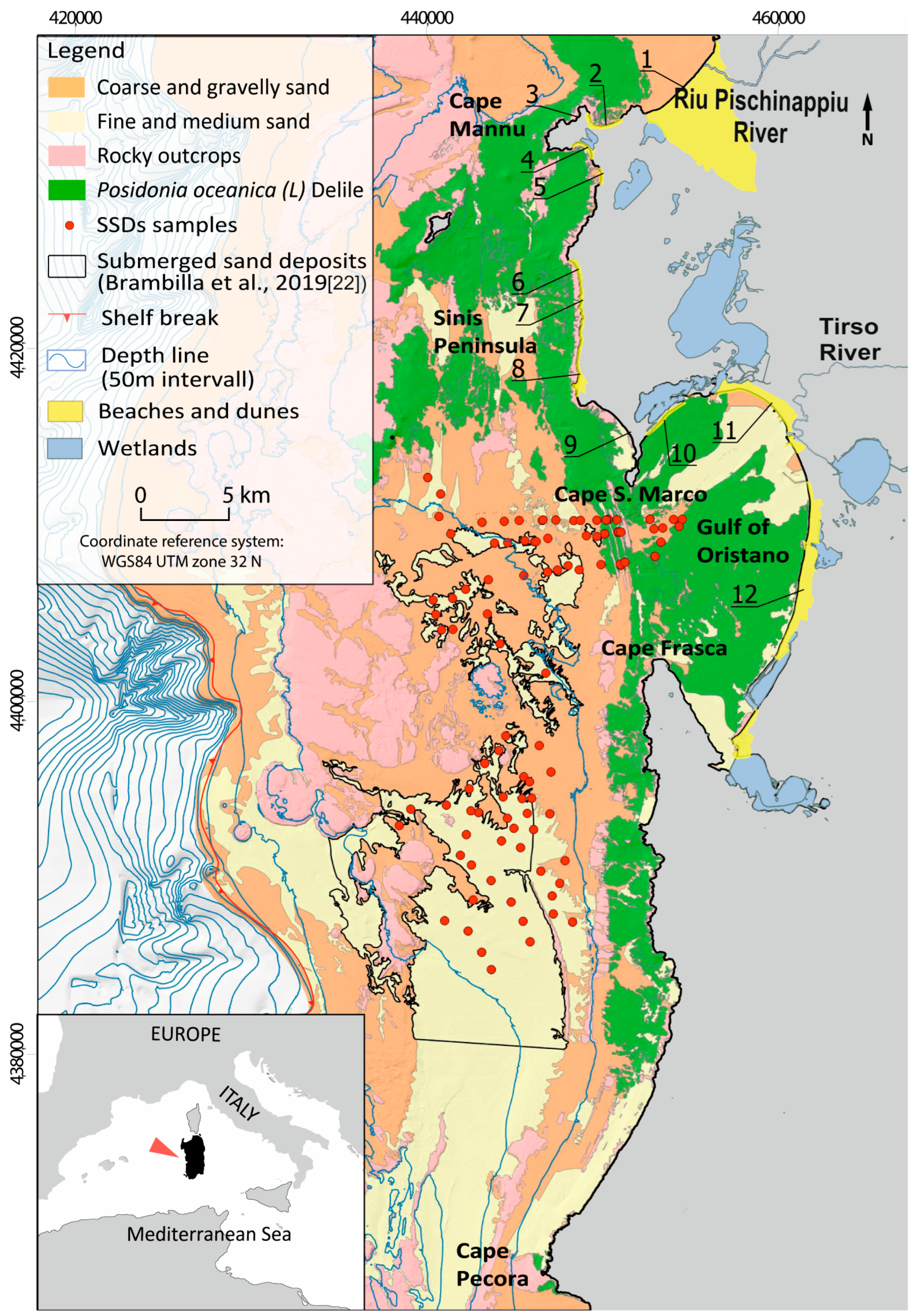
Figure 1. Map of the study area with localities and geomorphic features. Location of continental shelf with samples in the submerged sand deposits and beach areas (numbers from 1 to 12) analysed in this study are also shown.
Water 14 03971 g001
Figure 2. Coastal littoral cells as defined in the present study. (AG): cells or primary compartments. 1–12: beach areas or sub-cells. Blue arrows: longshore sediment transport direction.
Water 14 03971 g002
Figure 3. Mean grain size distribution groups (textural facies) in the beaches of the study area derived from EntropyMax.
Water 14 03971 g003
Figure 4. Discriminant score scatterplot for two discriminant functions: classification of 4 groups of sediment samples obtained by EM analysis (see Figure 2) and the unknown SSDs. Discriminant variables are: 4000 μm, 2000 μm, 500 μm, 250 μm, 125 μm, and 63 μm; (a) discriminant score scatterplot for two discriminant functions for siliciclastic beach sediments; (b) discriminant score scatterplot for two discriminant functions for siliciclastic SSD sediments; (c) discriminant score scatterplot for two discriminant functions for mixed beach sediments; (d) discriminant score scatterplot for two discriminant functions for mixed SSD sediments (e) discriminant score scatterplot for two discriminant functions for biogenic carbonate beach sediments; (f) discriminant score scatterplot for two discriminant functions for biogenic carbonate SSD sediments.
Water 14 03971 g004aWater 14 03971 g004b
Figure 5. Spatial distribution of both beaches and SSDs sediment samples defined by Discriminant analysis and carbonates content. G1, G2, G3, and G4: Groups identified by Discriminant analysis; 0–20% carbonate: siliciclastic sediments; 20–60% carbonate: mixed sediments; 60–100% carbonate: biogenic carbonate sediments. Square (in bold): to assess the availability of SSDs to a specific group (see Section 4 for description). (1-A) spatial distribution of siliciclastic beach sediments; (2-A) spatial distribution of mixed beach sediments; (3-A) spatial distribution of carbonate beach sediments; (1-B) spatial distribution of siliciclastic SSD sediments; (2-B) spatial distribution of mixed SSD sediments; (3-B) spatial distribution of carbonate SSD sediments.
Water 14 03971 g005
Table 1. Characterisation of cells and sub-cells (beaches) of the study area morphology, textural proprieties, composition, and sources of sediments.
SedimentsSediment Source
CellSub-CellBeach NameMorphology Textural Description% CarbonateD50 µm% Gravel% Sand
A1Is ArenasBeach–duneGravelly Sand/Slightly Gravelly SandMean SD47483338011%12%89%12%Riverine and transgressive relict sediments; ecosystem carbonate-producers
Min–Max425144115143%28%72%97%
B2Sa Rocca TundaEmbayedSandMean SD57134213340%0%100%0%Ecosystem carbonate-producers; cliff erosion
Min–Max347217711400%0%100%100%
3Sa Mesa LongaBeach–duneSlightly Gravelly Sand/Sandy GravelMean SD6556586249%18%91%18%
Min–Max557622024490%63%37%100%
C4Putzu IduBarrier–lagoonSlightly Gravelly SandMean SD3243711671%1%99%1%Relict sediment; cliff erosion; ecosystem carbonate-producers
Min–Max27401825970%5%95%100%
5S’Arena ScoadaEmbayedSlightly Gravelly SandMean SD251418571%1%99%1%
Min–Max2431781950%3%97%100%
D6Mari ErmiBarrier–lagoonGravel/Muddy Sandy GravelMean SD15232289109366%26%26%17%Transgressive relict sediments; ecosystem carbonate-producers [23,38,39]
Min–Max0768149860%100%0%61%
7Is ArutasEmbayedGravel/Sandy GravelMean SD0 268226383%13%17%13%
Min–Max 2094314054%100%0%46%
8MaimoniBeach–dune/barrierGravel/Sandy Gravel/Gravelly Sand/Slightly Gravelly SandMean SD921141795835%35%63%34%
Min–Max07022430630%100%0%96%
E9San GiovanniBeach–duneSlightly Gravelly Sand/SandMean SD62225062191%3%99%3%Ecosystem carbonate-producers; transgressive relict sediments; [14,33]
Min–Max2210028510690%16%84%100%
F10MistrasBarrier–lagoonSlightly Gravelly SandMean SD56245534517%13%91%13%Ecosystem carbonate-producers; riverine sediments; [40,41]
Min–Max157411713310%33%67%100%
G11TorregrandeBeach–duneSandy Gravel/Gravelly Sand/Slightly Gravelly Sand/Mean SD0 9965630.100.170.900.17Riverine sediments [28]
Min–Max 20923270%62%38%100%
12ArboreaBeach–duneSlightly Gravelly Sand/SandMean SD663811961%2%99%2%Riverine and transgressive relict sediments [29]
Min–Max1241598120%7%93%100%
Table 2. Colours of the cells and sub-cell together with the colours of the SSDs groups identified by the DA.
CellSub-CellMunsell Colour DescriptionMunsell Colour Code
A1Light Yellowish/Pale Brown10YR6/4–10YR6/3
B2Light Grey/Pink10YR7/2–7.5YR7/3
3Pink7.5YR7/4
C4White/Light Grey10YR8/1–10YR7/1
5Light Grey/White10YR7/1–10YR8/1
D6Pinkish Grey/White7.5YR7/2–7.5YR8/1
7Pinkish White/White7.5YR8/2–5YR8/1
8Pinkish Grey/White7.5YR7/1–7.5YR8/1
E9Pale Brown/Light Brownish Grey10YR6/3–10YR6/2
F10Light Brownish Grey/Pale Brown10YR6/2–10YR6/3
G11Ligth Grey/Pale Brown10YR7/2–10YR6/3
12Grey/Ligth Grey10YR6/1–10YR7/2
SSDs Groups
G1Reddish Yellow/Very Pale Brown7.5YR6/6–10YR7/4
G2Light Grey/Very Pale Brown10YR7/2–10YR7/3–10YR6/2
G3Very Pale/Ligth Brown10YR7/4–10YR7/3–10YR6/3
G4Reddish Yellow/Ligth Brown7.5YR6/6–7.5YR6/4–10YR6/4
Table 3. Group means of the discriminating elements for each function.
Group4000 mm2000 mm500 mm250 mm125 mm63 mm
135442061
2016185418
3002050281
4631151082
Table 4. Summary of the availability of compatible sediments from strategic deposits for each beach taking in account the grain size, the composition, and the colour properties.
CellSub-CellGrain Size
/Composition
Colour
A1NoNo
B2YesNo
3NoNo
C4YesNo
5YesNo
D6YesNo
7YesNo
8YesNo
E9NoNo
F10YesYes
G11YesYes
12NoNo
Publisher’s Note: MDPI stays neutral with regard to jurisdictional claims in published maps and institutional affiliations.