1. Introduction
Structural mitigation of landslides was an expenditure item on which there was substantial investment in the 20th century, especially in associated high-risk areas such as in Europe, North America, and Far East Asia [
1]. However, many of these structures are now increasingly old and damaged, significantly decreasing their capability to reduce risk. In Japan, for example, within 20 years, 60% of the Sabo facilities will exceed 50 years of age [
2]. The major concern about the deterioration of these structures is that this will result in a potential risk even higher than the one prior to the implementation of the countermeasure, such as the Barlin dam (Taiwan) failure in August 2007 that caused the sudden release of over 7.5 Mm
3 of stored sediment [
3,
4].
Three elements must be considered when facing the optimization problem regarding maintenance and/or replacement of old countermeasure works. First, risk aversion and risk tolerance are changing in several countries globally [
5]. Secondly, global population growth is pushing people to expand the road network. As a result, the urbanized areas in new locations may not be as safe as the historically built ones, especially near active debris flow and debris flood fans in mountain areas [
6]. At the same time, the population is becoming older, which means that more and more people require assistance during rapid evacuations. Consequently, the probability of landslides causing disasters and fatalities is increasing since it is also increasing (and changing) the number and types of exposed elements [
7,
8]. Thirdly, the modification of the precipitation patterns that most scientists attribute to climate change has a significant impact on the type and frequency of floods and landslide events [
9], and that should be taken into account in the assessment of the efficacy of structural mitigation works that have been designed 50 years ago considering a different climate.
An excellent example of this is well illustrated in the research of Junichi and Naoki 2020 [
10] about the Japan situation. According to the study, over the last 20 years, landslide processes caused 678 human fatalities in Japan, encompassing 21% of the total deaths due to natural disasters (excluding the Great East Japan Earthquake of 2011), and the most impacted age class is the elderly. Moreover, between 2000 and 2019, the number of landslides increased due to heavy rains and extreme events.
In this framework, it is evident that new countermeasure structures, reinforcements, and continuous maintenance of the old ones are needed. However, before that, each country would have to convert landslide damage into economic terms to evaluate the potential budget that would allow paying for all these works [
11,
12]. Further, some nations assign jurisdiction and responsibility for risk reduction control measures to local authorities, such as regions or even municipalities; in this case, the overall costs of all the required mitigation actions percolate through different institutions and are challenging to assess. One crucial example is Italy. In fact, despite the presence in its territory of two of the most important mountain ranges in Europe, rarely are the costs associated with countermeasure works for landslide stability taken into account by national or regional authorities.
Consequently, mountain municipalities and local communities must assume the critical economic burden of financing infrastructures designed to reduce landslide risk [
13,
14]. However, the annual cost that those small municipalities can bear is often minimal. Therefore, when faced with the issues of funding kindergartens or landslides’ countermeasures, the choice is evident and understandably the first. Moreover, in addition to degradation and sediment deposition in mitigation structures, which requires continuous use of economic resources for maintenance, local communities are often against extensive stabilization intervention that would lead to the appropriation of some of their properties or significant disturbance to the landscape [
15].
A possible strategy to limit the impact on mitigation structures is acting on the triggering factors of the landslide process. Unfortunately, these are not always so easy to identify. The other option is to produce very sophisticated geotechnical models of the landslide risk to design countermeasure works [
16]. However, these require a deep knowledge of the geotechnical and geological characteristics, such as subsoil reconstruction, groundwater regime, and rock/soil parameters burdened by high uncertainties. For this reason, numerical simulations, despite their solid theoretical basis, are not always the best option for producing a landslide model that is functional for mitigation.
On the other hand, careful analysis of an already present long-term series of recorded monitoring datasets such as inclinometric measures, Global Navigation Satellite System (GNSS) surveys, piezometers’ data, acoustic emissions, discharge rate, rainfall, and temperature reports can lead to significant statistical testing for correlation between slope movement and other variables [
17,
18,
19]. If the link is statistically significant, then it can be modeled using a gray-box approach [
20]. The latter requires mainly identifying a correlation between input and output with limited knowledge of the intrinsic process that produces the relationship. Another critical aspect is that the monitoring period should be long enough to catch a few high-intensity events to record the duration and magnitude of a landslide occurrence under these circumstances. This not only reduces the time and cost of modeling but also increases its reliability and predictive value as it is based on actual signals provided by the investigated landslides without introducing uncertainties regarding the rheological property of the landslide mass [
21,
22]. In addition, acting on the triggering factors rather than barring a landslide through steel and concrete deployment is generally cheaper [
23,
24].
Since water is one of the main triggering factors for landslides in the various forms of rainfall, snowmelt, groundwater, or surface runoff, water sequestration is usually one of the most successful forms of “soft countermeasure” [
25,
26,
27]. Given that landslides occur on steep mountain slopes, it is not so futuristic to think about using the potential energy of water runoff and velocity to produce power employing micro-hydropower plants. This has the potential to encourage municipalities to implement this mitigation strategy as it may become self-paying or, in some contexts, even profitable. This approach will be more and more feasible in the forthcoming future as research into and investments for designing efficient micro-hydro power plants are booming [
28].
The case study presented here is an example of this approach. The area is located in the upper Tagliamento Valley, where a main national road crosses through it. A medium-size landslide monitored for more than a decade intercepts the latter. However, despite the considerable risk of a paroxysmal event that would hinder the road’s usability, thus causing major disruption in the life of the valley inhabitants, only monitoring actions have been implemented since the Spring of 2022. This was due to the lack of resources of the municipality and jurisdictional disputes between the national and local authorities. In this context, we proposed a new mitigation strategy in 2019. It consists of pulling out the water that flows above and within the slope and funneling it away from the landslide to reduce the landslide’s movement.
Additionally, the water would not be directly returned to the Rio Verde downstream of the landslide. Thus, the ultimate plan calls for exploiting the available 130 m vertical drop to produce power by installing a micro hydropower plant. This solution would provide a long-term financial return that would pay for the stabilization costs, offer funds for maintenance, and possibly economic revenue.
2. Study Area
A large sector of the Eastern Alps falls within the borders of the Friuli Venezia Giulia region in North-East Italy. The morphology generated by these high reliefs and tectonics favors the existence of numerous areas with an associated high risk of landslides [
29,
30]. Additionally, the abundance of evaporites causes the formation of sinkholes [
31].
The most dominant hydrologic element in the region is the Tagliamento river. Its course is 178 km long with a basin of 2916 km
2 [
32]. Part of its mountain path in the Eastern Alps is closely linked to the Tagliamento fault’s presence [
33]. This relation originated in a 45 km E–W oriented valley traversed by a major national road called the SS52 “Carnica” that connects the upper plains of the Friuli Venezia Giulia Region with the industrial areas of the Cadore (Veneto Region).
The road is located in an area with confined morphology and high relief potential energy. Widespread landslides, such as rockfalls, slides, and snow avalanches, are frequent [
34,
35].
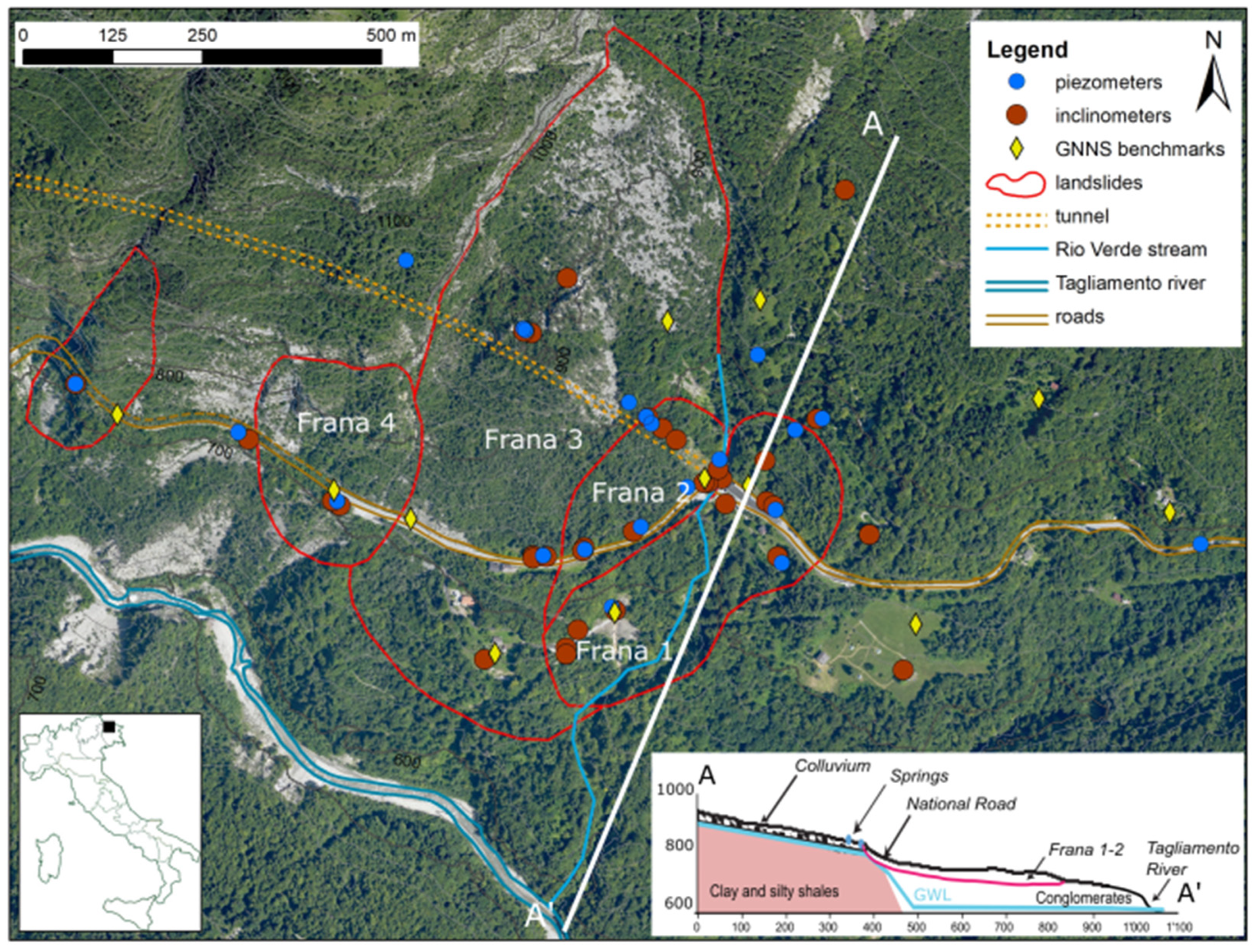
One of the most hazardous segments of the road is located on the left flank of the upper Tagliamento valley between Ampezzo and Forni di Sotto municipalities. It is called Passo della Morte (46.396 N, 12.715 E) (
Figure 1). In this tortuous tract, the avalanche and rockfall relative risk was so high that the construction of a bypass tunnel was needed. The works started in 1994, and finally opened in 2008. In fact, in 1996, during the construction, an extreme precipitation event disrupted part of the infrastructure. The extreme rainfall event allowed the discovery of two major slow slope movements, causing incapacitating road infrastructure problems. The first is a 24 × 10
6 m
3 slow-moving landslide called “Frana 3” [
36]. Frana 3 intercepts the road’s tunnel 300 m from the eastern entrance and in 1996, caused the collapse of the tunnel in this segment [
37]. The same portal and 200 m of the SS52 were affected by another 2.1 × 10
6 m
3 slope movement called “Frana 1-2” [
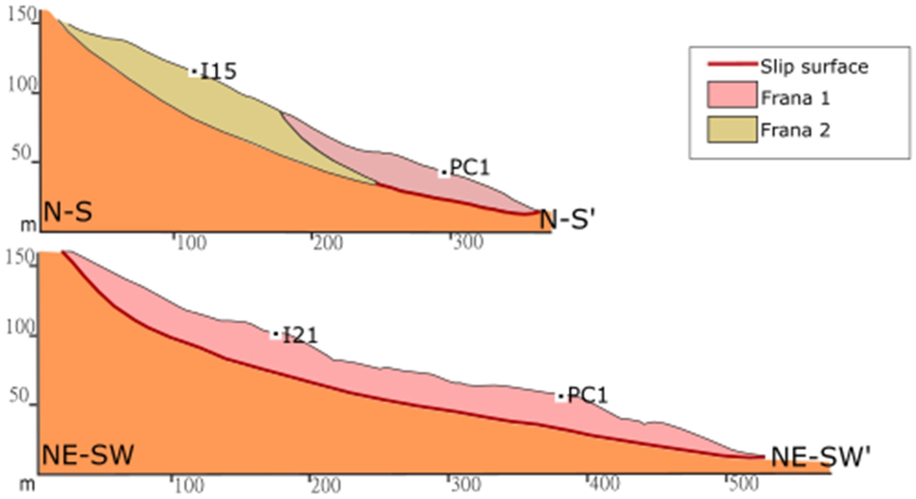
38]. The latter comprises two different rotational landslide bodies in the upper part that converge in the toe with a translational behavior.
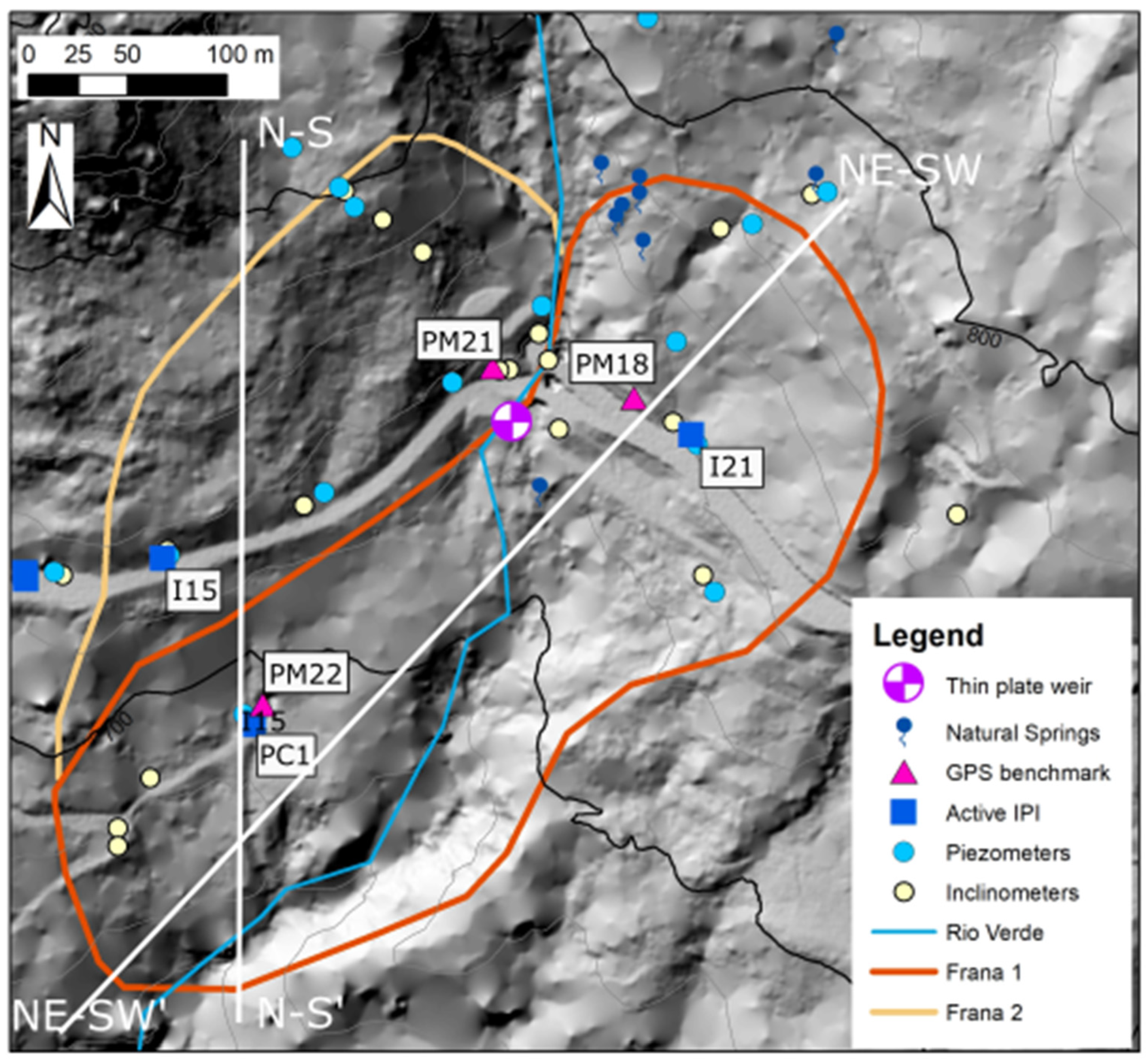
Frana 1-2 is cut across by the Rio Verde torrent. This same stream crosses the new and old national roads below a concrete box culvert. The retaining walls along the SS52 and the road pavement suffer continuous damage due to unremitting movements of heart-shaped landslide. To mitigate the slope movements of both the Frana 3 and the Frana 1-2, a drainage tunnel was drilled underneath the road tunnel in 2007. Despite that, this remediation strategy proved insufficient for a complete solution to the problem.
2.1. Hydrological Context
The Rio Verde basin covers an area of approximately 2 km
2 from 2122 m a.s.l. of Mt. Tinisa to the Tagliamento River at 578 m a.s.l. The upper part of the basin lies over the tectonized dolomitic limestone of the Monte Tiarfin Formation, which is affected by karst phenomena. In a different way, the lower domain is characterized by colluvium and back scarp deposit of Frana 3 consisting of dolomitic boulders. The runoff coming from the upper part of the basin, except for extremely intense rainfall events, is completely infiltrated into the groundwater circulation of the right bank of the Rio Verde and almost does not participate in the water discharge of the lower part of the torrent [
39]. In fact, the flow rate of the stream is mainly sustained by the water flowing from the springs located north of Frana 1-2. The stream guarantees an average “dry base flow” of 40 L/s related to the deep groundwater circulations, with long residence times set in the dolomitic limestone on the hydrographic western area of the Rio Verde Torrent [
40]. This dry baseflow represents an emergency source of water for the aqueduct of the nearby village of Ampezzo, when other sources of freshwater fail to provide enough discharge during arid summers. During extreme rainy events, the discharge from the springs can increase substantially, thanks to the rapid infiltration into the high-permeability debris at the base of the Tinisa massif [
20]. The geological context thus induces the water table to stay shallow near the contact between the clay and silty shales and the colluvium until the scarp of Frana 1-2 (
Figure 1). Then, all the groundwater that did not manage to surface through the springs and reach the Rio Verde, is again rapidly infiltrated into the conglomerates forming the landslide and then dispersed.
2.2. The Vaia Storm (2018) and Other Intense Meteorological Events
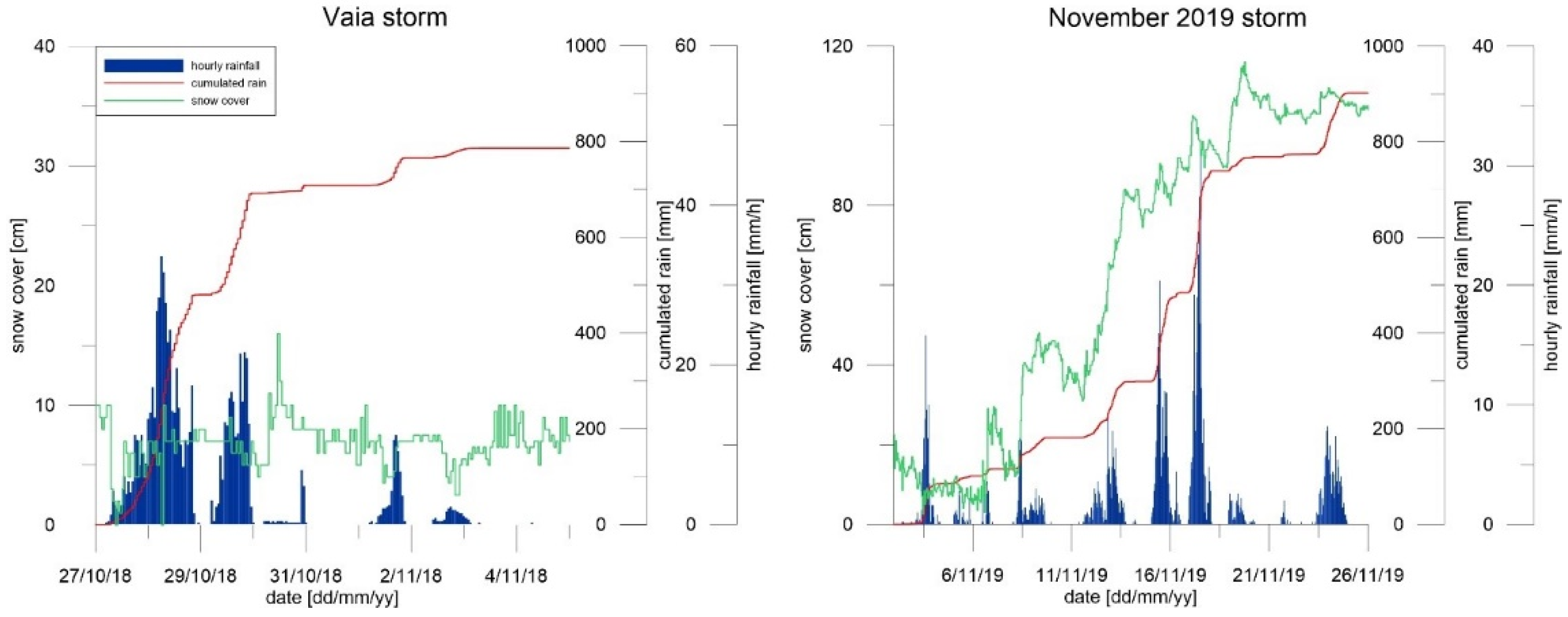
The Vaia storm was an extreme meteorological event that affected the Italian Northeast from 26 to 30 October 2018. The event originated following a perturbation of Atlantic origin. In the context of a strong wave of bad weather over Italy (also affecting the neighboring regions of Switzerland, Austria, and Slovenia), it brought strong winds and persistent, intense rainfall in the region, inducing floods and landslides. At the same time, the wind, blowing between 100 and 200 km/h for several hours, caused the felling of millions of trees, with the consequent destruction of tens of thousands of hectares of alpine coniferous forests. Several peripheral valleys were isolated due to road blocks caused by fallen trees or landslides, and the electric grid was out of operation for days. Vaia was a large-scale multi-hazard natural disaster in the Veneto and Friuli Venezia Giulia mountain areas.
In the Passo della Morte area, the Vaia storm brought a cumulated rainfall of 800 mm, almost 700 mm in the initial three days. Vaia was a hot windstorm, so all the precipitation in the first days was in the form of rain, even at 2000 m above sea level (
Figure 2). To provide a reference measure, this area’s average yearly accumulated rainfall amount is around 1700 mm.
In November 2019, another extreme event hit the Carnian Alps with an accumulated rainfall amount of 908 mm within a week in Passo della Morte. The event was intense; the peak daily accumulated rainfall was 250 mm on 17 November but lasted longer with constant and unremitting precipitation amount for days that were, however, in the form of snow above 1500 m a.s.l.
These two events induced significant disruption in the study area and are presented here since they are essential to interpret the 2018–2019 data and in understanding the following analysis and results.
2.3. Societal Background
As mentioned, the landslides in the Passo della Morte are constantly moving and damaging the road infrastructure [
37]. The Italian National Road Authority (ANAS) manages the new tunnel’s damage and associated risk. On the other hand, the jurisdiction is disputed over the 200 m of the road before the eastern entrance of the tunnel. In fact, several institutions could take charge of the slope’s stabilization. Among them, the Civil Protection of Friuli Venezia Giulia decided to act based on the monitoring data, given the high societal risk linked to the possibility of the failure of the only road serving the valley. In case of road disruptions, the logistical impact would be severe, with traffic detours through another valley and, consequently, damaging the local economy (the extra travel time for the local commuters might reach two hours).
The municipality of Forni di Sotto is also the most invested in resolving the problem. However, the municipality of Forni di Sotto is small (less than 600 inhabitants); consequently, the funds to finance a big slope stabilization plan are difficult to gather. On the other hand, the Civil Protection of the Friuli Venezia Giulia region can act and finance simple, environmentally friendly, and “light” solutions, but in any case, the municipality would be in charge of the maintenance of any countermeasure.
In this framework, the National Research Council of Italy (CNR-IRPI) has been consulted to design a low-cost, low-impact remediation strategy that would at least mitigate, if not stop, the movements of Frana 1-2. This was completed based on a long-lasting monitoring campaign and several modeling tests.
4. Gray Box Modelling
In 2019, Bossi and Marcato [
20] presented a gray-box model that could reproduce the velocity of displacement recorded in IPI I21Ter in function of the discharge of the Rio Verde torrent. The data presented in the paper stopped on 15 July, 2018. Of course, the system continued recording, and until the Vaia storm (end of October 2018), the correlation between the modeled velocities and the actual recorded ones produced a high fit to the model (R
2 = 0.82).
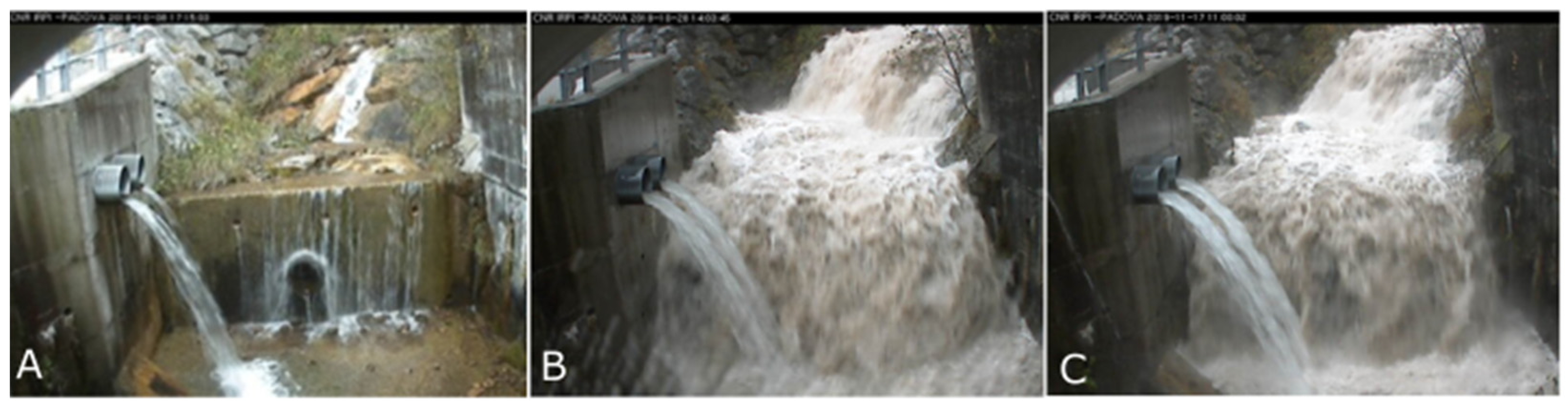
During the Vaia Storm, the peak discharge rate of the Rio Verde reached about 1000 L/s; we cannot be sure of the actual peak discharge of the flow since it was not confined in the small
adit of the measuring section, and in this condition our rating curve becomes imprecise. For the 2019 event, the estimated peak discharge was about 700 L/s. The lower discharge of the 2019 event is linked with the temperature regime that caused snow precipitation above 1300 m a.s.l. (
Figure 6).
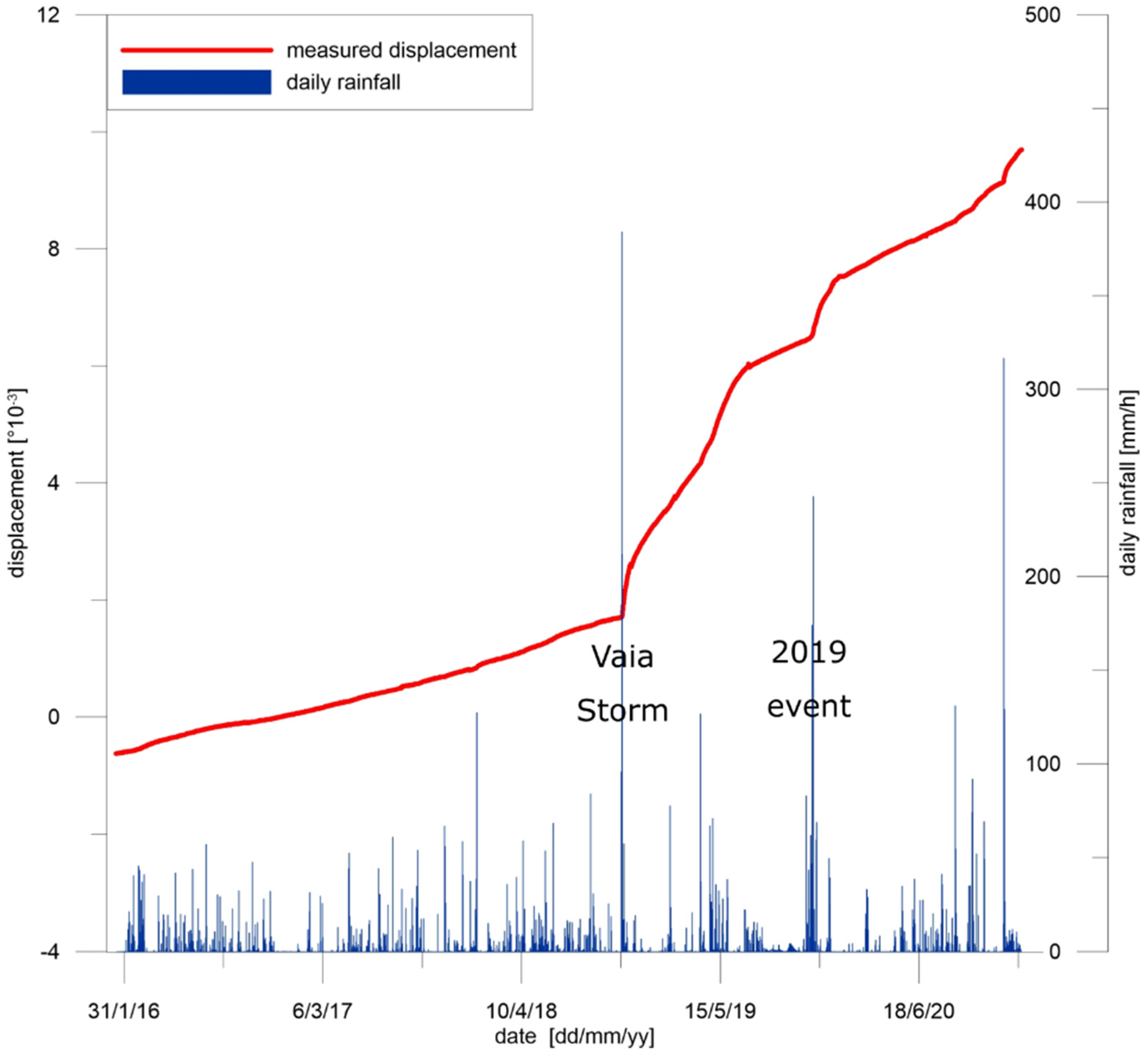
During the Vaia Storm, Frana 1-2 and Frana 3 landslides showed a marked peak acceleration never observed before in more than 12 years of continuous monitoring. It also caused damage to the emergency aqueduct due to the sudden displacement of Frana 1-2.
After Vaia, we also observed a marked change in the baseline velocity of inclinometer I21Ter (
Figure 7) linked to the storm’s effect that increased the landslide’s overall mobility.
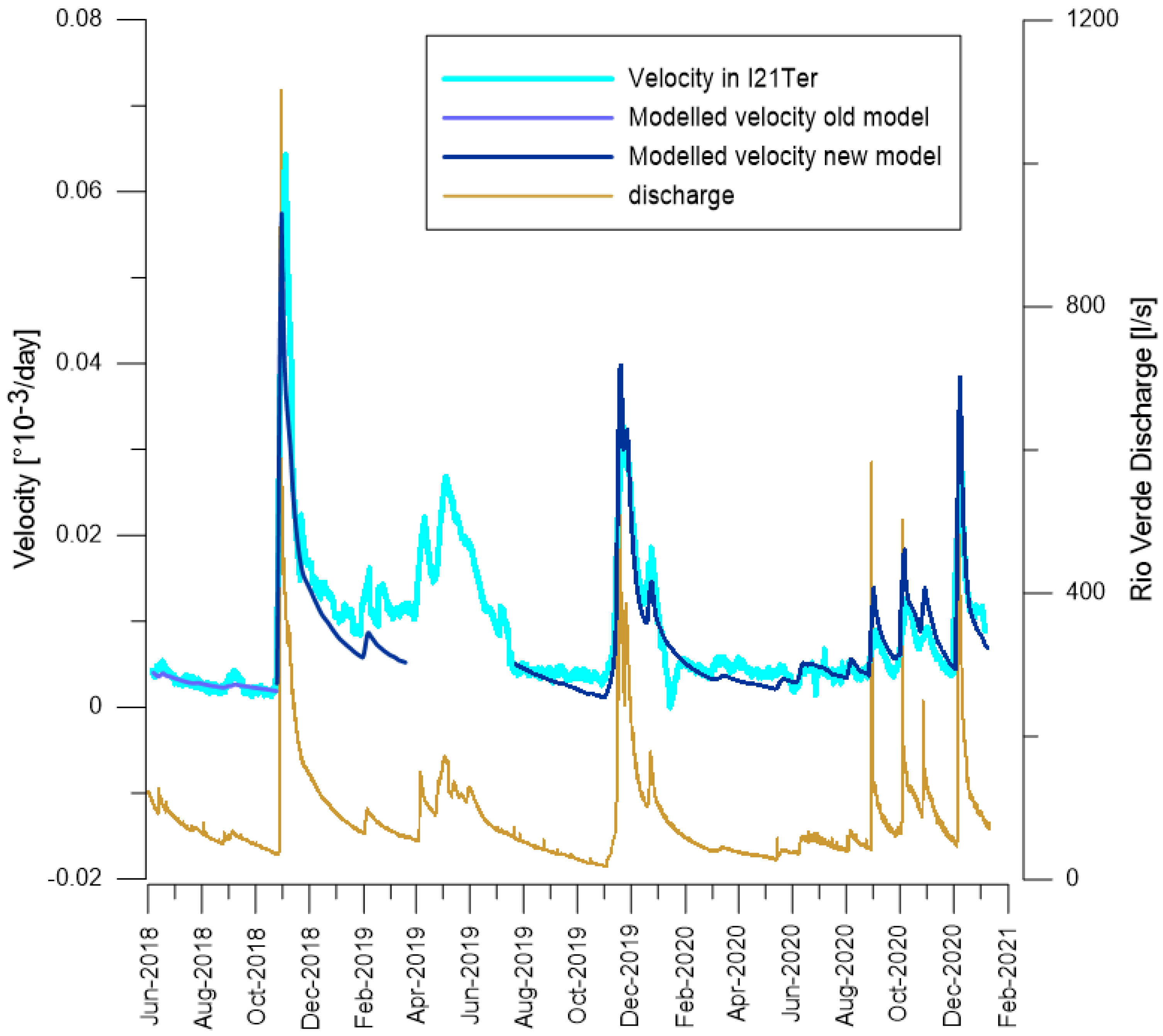
Therefore, a new equation to model the velocity change in the Rio Verde discharge was developed:
where (
) is the average flow calculated over the previous 5 days;
is the average velocity calculated over 10 days. The fit is linear as before [
20] and produces a coefficient of determination (R
2 = 0.86) that indicates a high fit of the data to the model, however, the coefficients differ from the pre-event gray-box model. The base-velocity was estimated based on the data from a dry period (from 1 March 2020 to 1 June 2020), when the discharge was lower and optimized to reduce the systematic error that is the average of the residuals. The new equation that fits the post-Vaia data can also reproduce the landslide dynamic during the 2019 event (
Figure 8). However, some data about the discharge needed to be discarded (from 19 March 2019 to 1 August 2019) as there were reliability issues for the measurements since the sensor was experiencing problems with limescale and sediment accumulation in the stilling basin. In July 2019, part of the accumulated sediment was removed, and the sensor was cleaned and repaired. On 1 August 2019, the rating curve for the discharge was re-tested and validated.
These strong results, showing a long-term direct correlation between the Rio Verde discharge and the displacements, convinced the local authorities (Protezione Civile Friuli Venezia Giulia) to start the realization of remediation works based on the reduction in the flow discharge in the Rio Verde stream.
5. Implementation of the Risk Mitigation Strategy
A cost–benefit analysis was performed to decide the optimum value of discharge to be extracted. The elements that were considered were: (1) the expected reduced displacements; (2) the expected cost of the construction works; (3) the expected economic revenue from the hydro plant; and (4) the environmental impact both in terms of bioenvironmental effects on the stream and from the visual impact on the landscape.
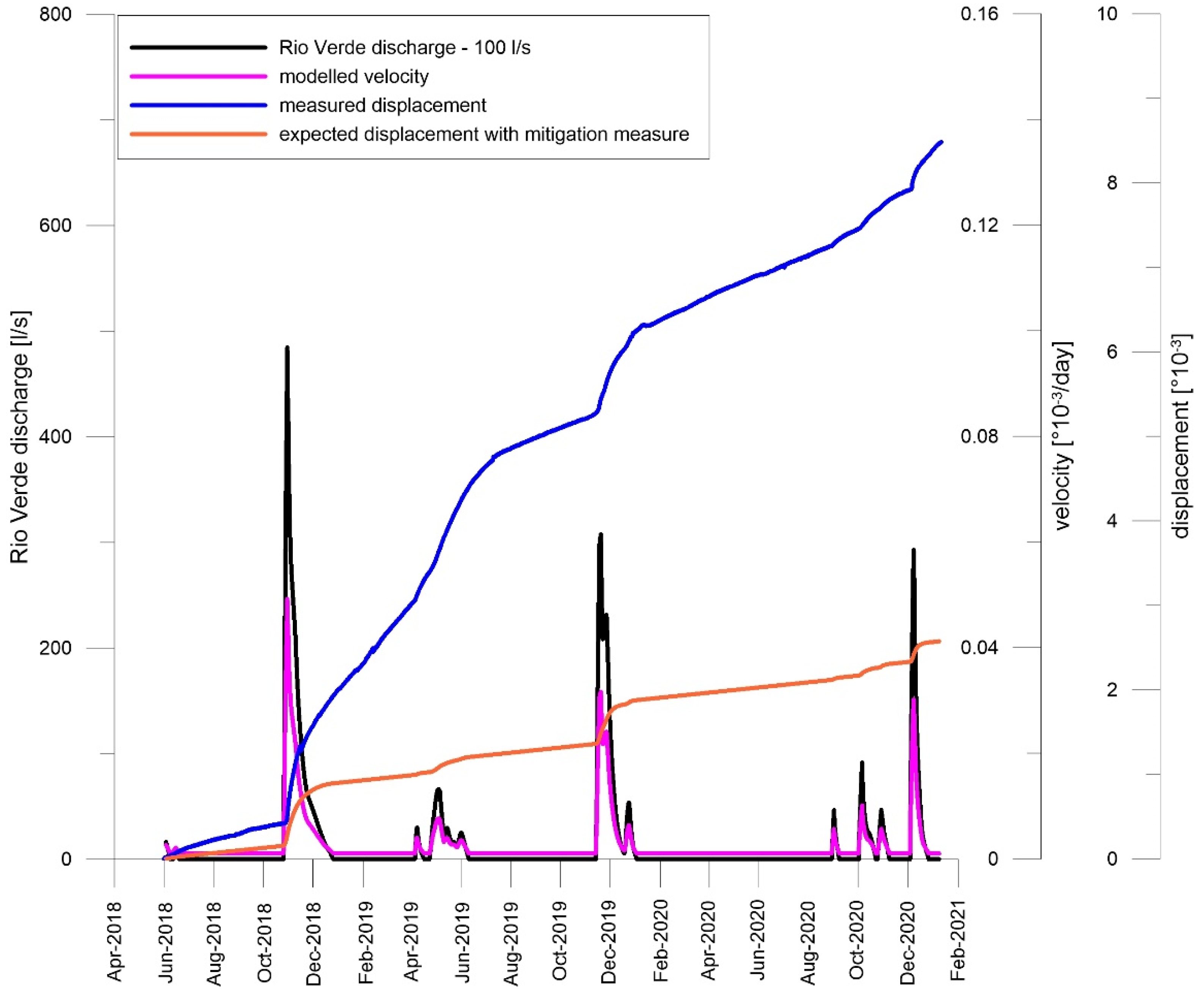
If we calculate, for the period June 2018–January 2021, the expected displacement considering sequestration of 100 L/s with the linear model, and we confront them with the measured displacements, the decrease in the movements reaches about 70% (
Figure 9). The value of 100 L/s represents an optimum considering both the Rio Verde flow regime and the possible countermeasures’ size.
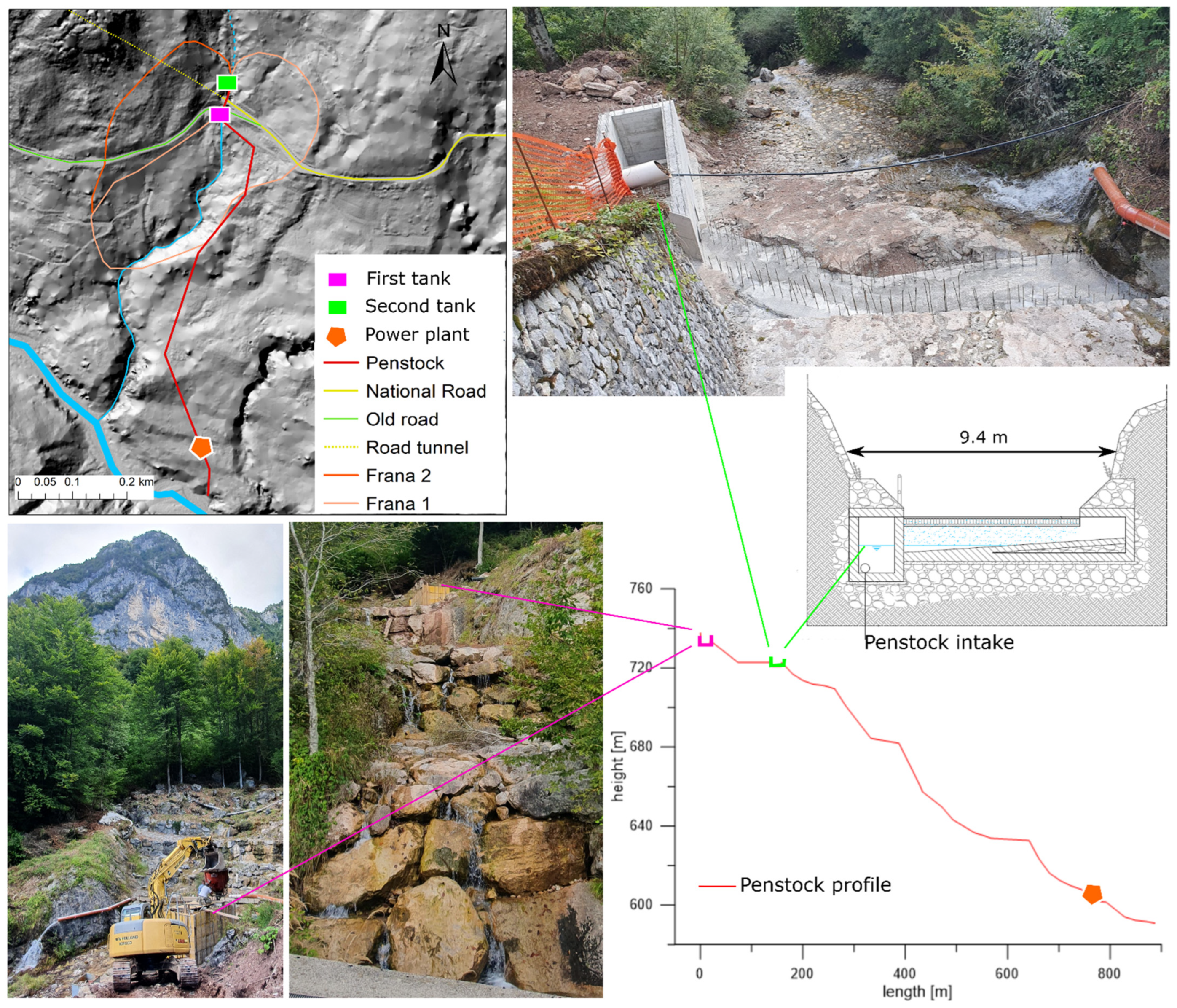
The project calls for constructing two small (10 × 2 m) transversal sedimentation/intake basins in the upper part of the slope (
Figure 10). The need for sediment removal is not so crucial during dry periods when the spring water component is prevalent, but it is fundamental during extreme rainy events.
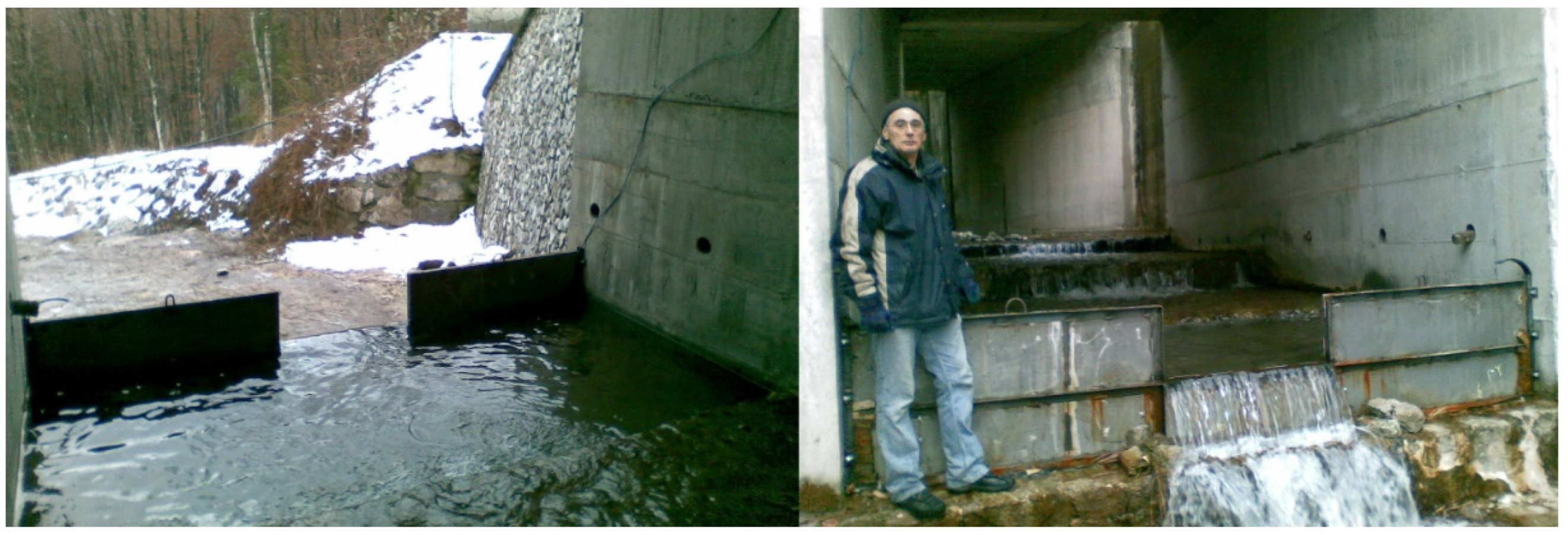
The first tank will be placed on the Rio Verde upstream of the road bridge. Here, the water from the natural springs above the road (except those serving the emergency aqueduct) will be conveyed through sub-horizontal drains and little spillways. Then, with a pipe, the water will reach the second intake basin, placed downstream of the bridge, where all the discharge from the drainage network of the road tunnel will be collected along with the water from lower springs. Funneling the water below the bridge through a pipe is necessary due to large cracks in the culvert below the bridge that could cause water loss through infiltration.
A 900 m long HDPE (High-Density Polyethylene) penstock is currently under construction. It will gather the discharge to the Tagliamento river at an altitude of 590 m a.s.l. The total cost of these works for the Friuli Venezia Giulia Civil Protection will be around 800,000 EUR.
6. Discussion Regarding Costs and Self-Sustainability
As emphasized in the introduction, it is essential to consider economic revenue for the municipalities to incentivize them to implement mitigation strategies and maintain the countermeasure works. That is why, in this study, the integration of the remediation system with a micro-hydro plant has been proposed. In Italy, the latter (5 kW to 100 kW) is subsidized on a national basis, giving 0.22 EUR/kWh. Consequently, for the Forni di Sotto municipality, the micro-hydro plant option is an excellent solution for exploiting the discharge of the Rio Verde stream by producing electric power and selling it to the national network.
For the hydroelectric exploitation of the system, the horizontal axis Pelton turbine is optimal, considering the available 130 m drop and low average flow rates of the torrent. The turbine should be integrated with a three-phase asynchronous generator with a rated power of 100 kW. This generator is cheaper and requires less maintenance than a synchronous generator of the same deliverable power. Additionally, considering the quality of the water entering the hydro plant, which is very poor in terms of the level of sediments, it is believed that the conservation of the turbine will be excellent. This power plant will be located over an old fluvial terrace of the Tagliamento river (603 m a.s.l.). The position is isolated and not subject to landslides or erosion. This will reduce the landscape impact and the risk of damage. In addition, the building will be more than 10 m above the active course of the Tagliamento river to avoid any chance of damage by the river’s floods. To further mitigate the impact on the landscape, the penstock will be buried in the soft colluvium present in the area which is easy to excavate.
The minimum predicted discharge of water funneled into the plant would be around 15 L/s, while the maximum will be 100 L/s with an estimated average of 45 L/s. Considering the 130 m drop, an average nominal power at 58.27 kW has been calculated: the yearly mean production will be 378,000 kWh. This will allow the municipality of Forni di Sotto a profit of 65,745 EUR every year, considering a selling price of 219 EUR/MWh, while the total cost of the hydro-plant will be around 300,000 EUR. As shown in
Table 1, this relevant financial intake will pay for the power plant in less than five years. After that, the additional profit will finance the maintenance of the mitigation strategy of Frana 1-2 and probably provide economic income for the municipality.
Given the relatively low cost of the operation and the possibility of revenue, the local authorities deemed the project worthy of a try. During several meetings the expected output, and the unlikely possibility that the project as it is would not work, were presented. What was crucial from the general risk assessment point of view was the fact that it would be simple to reinstate the fluvial system and the landslide area to its original condition if the expected reduction in displacement targets were not met. Moreover, it would be, in any event, a much easier option than with other structural mitigation works that were considered over the years [
41]. Lastly, the project would not interfere with secondary structural mitigation solutions implemented in a stepwise manner if in the future the target would be stopping the landslide altogether rather than reducing its displacements. Actually, it would have decreased for some time the stresses within the slope, thus allowing smaller “bolts and nails” countermeasures.
The Civil Protection of Friuli Venezia Giulia was so involved in this project that it also financed an additional monitoring campaign consisting of two permanent GNSS stations deployed on the Frana 1-2 landslide. In this way, the reduction in the superficial movements will be assessed with a state of the art technology.
7. Conclusions
A constant flow of money is needed to maintain old landslide mitigation structures and build new ones, given the increasingly risk-averse attitudes from the exposed population. This leads to developing countermeasures that are easier to restore and less expensive.
Most of the time, when dealing with small-to-medium landslides, the usual pipeline followed by engineering geologists is to reduce the monitoring phase to a minimum (due to time and budget constraints), test some soil samples, develop a geotechnical model of the landslide based on laboratory results and on this model design the structural countermeasure works. Unfortunately, due to the high uncertainties linked with this process, the countermeasures are usually over-dimensioned and thus overpriced [
42].
Acting on the triggering factor, when possible, is way more focused and surgical. However, the monitoring activity needs to be pursued in more extended periods than usual and with several different instruments for robustness. While the time factor is in itself a cost, we cannot forget that these slow-moving landslides are usually chronic phenomena that are, in any case, bureaucratically taking a long time to pass through all the phases from the identification to the actual mitigation. Moreover, from the mere actual cost point of view, the cost of a well-designed monitoring network is a tiny fraction of the cost of a classic “walls and nails” mitigation structure.
Thanks to long-term monitoring data in Passo della Morte, a strong correlation and model fit between the velocity of the displacement of Frana 1-2 and the discharge of the Rio Verde stream was found. The gray-box model presented by Bossi 2019 [
20] was validated by the data gathered in the months after publication until the Vaia storm. Then, the landslide dynamic changed, showing an increase in the baseline displacements. In any case, even this new behavior is still strongly linearly correlated with the water discharge in the Rio Verde torrent, as previously stated.
Considering this result, local authorities have started constructing a series of tanks and penstocks to redirect the majority of the stream’s discharge. The cost of this type of mitigation action for the Civil Protection is around 800,000 EUR. With an additional 300,000 EUR from the municipality of Forni di Sotto, this solution could be associated with a micro-hydropower plant that has the potential to payback its cost in five years. The future profits will guarantee the maintenance of the mitigation system itself and probably some economic income for the municipality. Moreover, this kind of countermeasure would drastically reduce the visual impact on the landscape compared to extensive engineering slope stabilization or large Sabo works.
Another advantage of this type of design is that it is scalable. The monitoring system will be maintained and enhanced with a permanent GNSS receiver along with the tanks and penstocks. This will allow for the precise quantification of the displacements, confronting them with the estimate from the gray-box model, and checking to see if the reduction in movements is in line with what was expected. In this case, the Passo del Morte case study serves as a benchmark for implementing this type of low-cost remediation solution.


