Article

A Localized Assessment of Groundwater Quality Status Using GIS-Based Water Quality Index in Industrial Zone of Faisalabad, Pakistan

1
Department of Structures and Environmental Engineering, University of Agriculture, Faisalabad 38040, Pakistan
2
Department of Civil Engineering, Faculty of Engineering & Technology, Islamia University Bahawalpur, Bahawalpur 63100, Pakistan
3
Department of Biosystems and Agricultural Engineering, Oklahoma State University, Stillwater, OK 74078, USA
4
Department of Electrical and Electronic Engineering, Pabna University of Science and Technology, Pabna 6600, Bangladesh
5
National University of Modern Languages Islamabad, Multan Campus, Multan 59300, Pakistan
*
Authors to whom correspondence should be addressed.
Water 2022, 14(20), 3342; https://doi.org/10.3390/w14203342
Submission received: 2 September 2022 / Revised: 12 October 2022 / Accepted: 18 October 2022 / Published: 21 October 2022
(This article belongs to the Special Issue Emerging Contaminants (ECs) in Water)

Abstract

:
Groundwater risks driven by population growth and industrialization in metropolitan cities have become a worldwide problem. Faisalabad is Pakistan’s third largest city with a population of more than 2 million and is renowned for its diverse industries. Many factories in the area dump their untreated effluent into nearby drainage systems, having a direct negative effect on the marine ecosystem. This research focuses on the Madhuana drain and Khurrianwala industrial region of Faisalabad to investigate groundwater quality status. Sixty water samples from groundwater bore wells and open wells were obtained, and all these samples were subjected to lab experiments for physical and chemical analysis. Sixteen physiochemical parameters, namely, electrical conductivity (EC), pH, total dissolved solids (TDS), total suspended solids (TSS), turbidity, carbonate, Ca2+, Fe, HCO3, Cl, Mg2+, SO24−, As, Cr, Cu, and Mn, were examined. To provide a comprehensive picture of water quality from a human perspective, we calculated the water quality index (WQI) by integrating 16 physiochemical criteria. The results revealed that a larger proportion had poor drinking quality due to direct releases of toxins by industries. It was observed that 87% of the water samples showed an unsuitable status of groundwater for drinking purposes in terms of pH, EC, Fe, Mn, Cu, and Cr. The results of this study could be used to build and construct wastewater treatment plant facilities for the Madhuana drain, reducing pollution loads on the drain and river, as well as contaminant seepage rates into groundwater. The research’s resulting maps will help policymakers to manage groundwater supplies more efficiently for sustainable development.

1. Introduction

Excessive pumping from a groundwater aquifer for agricultural and industrial use has not only reduced groundwater levels but also harmed the quality of drinking water [1]. Groundwater is perhaps the most crucial component of our life support system, and it also contributes significantly to economic development [2]. Despite its importance, groundwater has been severely depleted by growing human consumption and industrial activity [3]. According to the Pakistan Bureau of Statistics (2019), Pakistan’s population was barely 32.5 million at the time of its independence, growing exponentially to 207.77 million in 2017. This rising demographic pattern poses significant challenges to the country’s limited natural resources [4]. The once-abundant water supply of Pakistan has dried up, and the nation now is facing a severe water shortage. The availability of water per capita, which was 5300 m3 in 1951, has now decreased to 1105 m3, thereby exceeding the 1000 m3 mark of water scarcity [5]. Increasing population, depleting water storage facilities, and environmental damage to natural water supplies due to drainage of untreated agricultural and sewerage wastes into streams/rivers are the key causes of diminishing water supply [6]. The management of domestic and industrial wastewater is a major concern as it threatens the availability of freshwater, human health, and agricultural development [7]. Due to seepage from drains and settling basins, the consistency of groundwater is impaired [8]. In urban and industrial areas, the issue of major water quality declines is becoming more serious, which have triggered the spread of waterborne diseases and other irrecoverable environmental degradation. Rapid building and industrialization have had a severe impact on the climate and neighboring surroundings [9]. Due to insufficient or inaccessible sewerage facilities and the high cost of alternative wastewater disposal and treatment methods, large volumes of raw wastewater are disposed of in the sewage system, leading to several environmental problems, including the emission of hazardous gases and air emissions over highly polluted cities in Asia [10].
Many Asian countries have transitioned from being mostly reliant on agricultural production to being significantly dependent on industrial output. Foods, electronic components, metallurgy, chemicals, rubber and plastic industries, masonry, and textiles are the fastest-growing industries, and their production has increased by 20–45% in recent years. There are at least 30 Asian and Pacific nations that have industries accounting for more than 20% of their overall GDP [11]. Although there has been an improvement in awareness of climate change in the industrial sector, medium-sized industries still dominate the area, making it difficult to impose regulations and contributing to pollution growth [12]. In particular, for the poor and middle-income countries in the ASEAN region, the measurement of surface water quality is frequently time-consuming, expensive, and tiresome, in addition to being impracticable. The water quality index (WQI), which is based on multiple independent critical criteria, has significant potential and is an effective method in this area [13].
During the colonial period, Faisalabad was a famous agricultural product market town. The growing urban sprawl has resulted in the development in the city of several agro-based textile industries [14]. At the time of liberation, there were only five manufacturing units. In Pakistan, the city has now acquired Manchester status, as there are hundreds of textile industry units with other minor units. Approximately 6.45 m3/s of effluent is created in Faisalabad [15]. WASA Faisalabad has set up a network of tiny urban drainage canals to collect sewerage and industrial waste. Many of these city sewage disposal channels dispose into one channel, that is, Paharang drain, and other channels into the Madhuana drain. The drain of Madhuana begins in Khurrianwala, passes close to the town, takes squander water from the eastern side of the town, and releases it into the Ravi River. The effluent framed in the western pieces of the city is depleted into the River Chenab through the Paharang channel. Most of the drainage system is unlined, which eases the seepage of heavy metals and deteriorates the groundwater quality. It is necessary to investigate the groundwater quality status as no such findings are available for the selected study area.
The evaluation of the quality of groundwater has become highly essential for the sustainable development of fresh groundwater aquifers due to the large number of industries in Faisalabad. The knowledge of the spatial distribution of environmental parameters is essential for evaluating the water quality [16]. Since monitoring is costly, particularly for large areas of groundwater, accurate and versatile instruments are required to assist with such monitoring strategies [17]. These issues can be solved by using modular tools, such as a geographic information system (GIS), as fewer observation wells are required to assess the groundwater quality of the entire area, and the potential cost is also minimized [18,19]. One of the most widely used methods to classify and reflect the water quality situation for a particular location is the GIS-based water quality index (WQI) [20]. A valuable method for water quality control is the mapping of water quality indices within the GIS. It helps to provide three-dimensional patterns in water quality variance to clarify the current situation concerning various parameters of the water quality investigated. Several researchers in different countries have applied WQI to evaluate the water quality of that region [21,22,23,24,25]. Different authors in Pakistan have also assessed groundwater quality maps using WQI. In Faisalabad, a few researchers, such as [4], have checked the groundwater quality in Chokera, which is the western part of Faisalabad, by applying WQI. However, there was no groundwater quality map developed for the eastern side of Faisalabad, where the Madhuana drain collects wastewater from textile mills in the Khurrianwala neighborhood. Most of the textile industries in this region do not have any treatment facility for wastewater and toxic wastewater, which is discharged into the Madhuana drain without any treatment, which seeps down and ultimately affects groundwater quality.
The current study attempted to localize the assessment of groundwater quality status in the industrialized zones of the Khurrianwala region by collecting water samples from over 60 locations. The study aims to assess the groundwater quality of the Khurrianwala region with the help of 16 physiochemical indicators and subsequently prepare a geospatial water quality map using a GIS-based water quality index (WQI) at a distributed scale (10 m2). The subobjectives of this study are to (1) conduct a laboratory scale assessment of groundwater quality by collecting physiochemical data of 16 indicators and (2) weightedly overlay the physiochemical characteristics of the 16 indicators in ArcGIS to generate WQI for an industrial zone.

2. Materials and Methods

2.1. Study Area and Sampling Locations

This study was carried out in Khurrianwala, a Faisalabad city industrial zone located in Punjab Province with a total area of 5856 km2. The average elevation of the study area is 184.14 m (604 feet) above mean sea level (Figure 1).
Sixty sampling stations were established throughout the study region (Figure 1). Open wells and bore wells, which were widely utilized for agriculture, drinking, and other home and industrial uses, provided water samples. Water samples were collected in polypropylene containers that had been properly washed with sample water multiple times before being used. PVC bottles were labeled with the sample code, date, time, drain name, and GPS coordinates before sampling. During the field activity, all water samples were kept in an iced cooler. The samples were kept in a refrigerator at a temperature of 2 to 4 °C in the laboratory. All conceivable steps were taken to limit contamination during sample collection and processing. These samples were collected between January and March and tested using American Public Health Association [26] standard techniques for various physiochemicals.

2.2. Analysis of Samples

Electrical conductivity (EC), pH, total dissolved solids (TDS), total suspended solids (TSS), turbidity, carbonate, Ca 2 + , Fe, HCO 3 , Cl , Mg 2 + , SO 4 2 , As, Cr, Cu, and Mn were the 16 physiochemical parameters that were examined using the standard methods described by [27].
The pH of the samples was determined using a digital pH meter. The electrical conductivity of the samples was determined using an EC meter. Suspended and dissolved solids of samples were determined using the oven-drying method. To conduct this experiment, evaporating dishes were washed and placed in a muffle furnace at 550 °C for 30 min. Dishes were then cooled at room temperature, and the dishes’ empty weight was named W1. An amount of 50 mL of a well-mixed sample was poured into the dish and allowed to evaporate in an oven set to 103–105 °C for 1 h. Then the dish was allowed to cool in the air for a few minutes before placing it in a desiccator to finish cooling in a dry environment. As soon as the dish had cooled fully, it was weighed again and named W2 [24]. The following mathematical expression is used to calculate the total solids (TS):
TS = W 2 W 1 V × 10 6
where V is the volume in mL and TS is calculated in mg/L.
A filter paper was used to measure the concentration of TDS (total dissolved solids). An amount of 500 mL of the sample was filtered using filter paper in an evaporating dish that had been previously prepared and weighed, which was subsequently placed in the oven at 103–105 °C for 1 h. Another weight reading of the dish was taken when it had cooled to room temperature, and then it was labeled W4. The experiment used gram weights for the calculation of TDS. Equations (2) and (3) were used to calculate TDS and TSS values in each sample [28].
TDS = W 4 W 3 V × 10 6
TSS = TS TDS
A turbidity meter was used to determine the turbidity of water. Carbonate and bicarbonate concentrations were determined using a titration method in which samples were titrated in the lab with a 0.02 N HCl solution.
To calculate chlorides, a 10 mL sample of water was taken, and 3 drops of potassium chromate indicator were added. A standard 0.02 M silver nitrate solution was used as titrant, and the endpoint was a pinky yellow color. At that point, burette reading was noted, and chlorides were estimated using Equation (4) [29].
Cl   ( mg L ) = Burrete   Reading   × 35.45
Carbonate was present in the water when the pH of the sample was above 8.3. To perform this test, a 10 mL sample was poured into a beaker, and one drop of phenolphthalein was added. The pink color appeared in the sample. It was then titrated with a solution of 0.02 N HCl until the liquid pink color disappeared. Burette readings were recorded and rerecorded a total of 100 times. Carbonates were measured in parts per million (ppm).
To calculate bicarbonate, a 10 mL sample of water was taken, and 2 drops of methyl orange were added. As a result of the addition of a bright yellow color, a sign of the presence of bicarbonates appeared. Titration was then compared with a solution of 0.02 N HCl until the color changed to orange yellow. Burette readings were noted and multiplied by 100 to calculate bicarbonates at ppm.
To calculate calcium, a 10 mL sample of water was diluted with 10 mL of distilled water. A 0.4 mL NaOH solution and 0.04 g of murexide indicator were added to it, which gave a pink color. Then this solution was titrated with 0.01 M EDTA. The endpoint was a purple color from pink. Equation (5) was used to estimate calcium [26]:
Ca   ( mg L ) = ( D E ) × 400.8 mL   of   Sample
where D was an mL titrant and E was mg CaCO3 equivalent to 1 mL.
Magnesium was estimated using the following Equation (6) [26]:
Mg   ( mg L ) = Total   Hardness   as   CaCO 3 2.5   ( Calcium   in   mg / L ) × 0.243
Heavy metal analysis was performed on a Hanna HI83399 multiparameter photometer [30]. The same approach was used to calculate all heavy metals; however, each time a parameter was altered by utilizing the HR method key on the instrument. An amount of 10 mL of the sample (up to the mark) was filled in a cuvette in a holder each time for every test. Then the Timer button was pressed, the countdown appeared on the screen, then the Measure button was pressed. The meter takes the reading when the timer stops. The instrument showed the final concentration of the concerned heavy metal in the sample in mg/L. Analyses were performed until 95% precision and ±5% precision were achieved.

2.3. GIS Analysis

A geographic information system (GIS) is a user-friendly open-source platform for data analysis (e.g., extracting and interpolating experimental data and creating different spatial maps). A GIS-based water quality index establishes a statistical relation between groundwater parameters and reduces the uncertainty of groundwater parameters to describe the groundwater quality of the region in graphical format [31]. The sampling stations’ latitude and longitude were determined using a handheld GPS unit. The sampling sites with all experimental data were loaded to GIS, and every sample point was given a unique code that was saved in the point attribute table. Separate columns for the values of all the chemical parameters were included in the database file, along with sample codes for each sampling location. There are several interpolation techniques, such as kriging, IDW, and cokriging, to interpolate data spatially; however, these kriging approaches are most widely applied to map water quality parameters [32,33,34]. This study adopted the kriging technique to estimate the unknown values based on the global mean from known point values and was used to create spatial distribution maps of all selected water quality parameters. The OK approach uses the empirical semivariogram model to give weights to observed values based on spatial and statistical correlations, allowing for the prediction of values in unknown places [35]. Additionally, several researchers have used this technique to create spatial maps for a variety of water quality parameters [24,36,37,38]. Groundwater pollution may be understood by individuals and decision makers with the use of interpolated maps, which provide a comprehensive picture of hydrochemical processes alongside the drainage network of the research area [31].

2.4. WQI Analysis

The water quality index is one of the most powerful methods for gathering knowledge on the quality of any water source. The water quality index (WQI) is a statistical formula for transforming large numbers of data on water quality into a single number [39]. For policymakers regarding the efficiency and future uses of any water body, it is simple and easy to understand. Combining complicated data and producing a score that defines water quality status explains water quality concerns. The WQI was used to determine groundwater quality in the research area since it is a valuable technique for assessing drinking water quality in general. According to [40], the WQI development process generally comprises four steps: (1) parameter identification, (2) subindex development, (3) weight assignment, and (4) accumulation of weighted subindices. Different water parameters were chosen, and the World Health Organization (WHO) recommended that drinking water requirements be taken into account for those parameters. The criteria were then given a weight (Wi) ranging from 1 to 5, with 5 representing the highest weight, based on the perceived impact of these contaminants on human health. The following four processes were taken into account to determine the water quality index (WQI):
Step I: Every parameter is given a weighting based on literature values [24], and the relative weightage Wi for each parameter was calculated using the following formula:
W i = w i i = 1 n w i
where
  • W i   = relative weightage of the ith parameter;
  • w i = weight assigned to the ith parameter;
  • n = total number of parameters.
Step II: The quality rating was calculated using the following formula:
Q i = ( c i ) / s i  
where
  • Q = quality rating;
  • ci = concentration of each sampling parameter;
  • si = permissible values of each parameter as recommended by WHO.
Step III: The following formula was used to find the subindex:
SI i =   W i × Q i
where
  • SIi = subindex of ith parameter;
  • Qi = quality rating of ith parameter.
Step IV: Finally the following expression was used for calculating the final water quality index (WQI):
WQI = i = 1 n SI i

3. Results

Understanding groundwater quality is critical because it is the primary determinant of its appropriateness for drinking. Table 1 shows a statistical summary of the selected chemical and physical properties of water from the sampling sites.
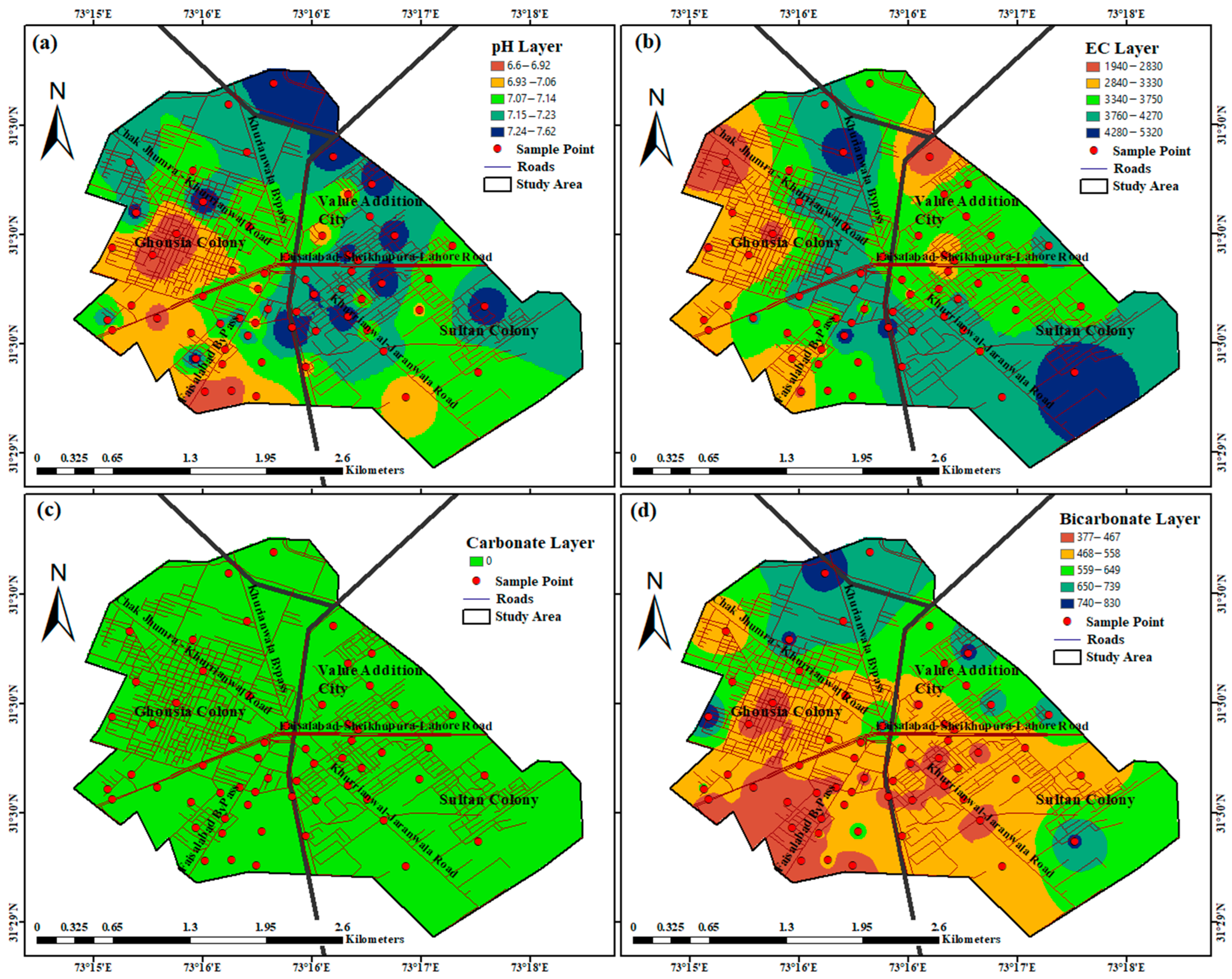
pH status: pH, which has no direct effect on consumers, is typically among the most essential indicators of water quality. The ideal pH level is between 7.0 and 8.5 in most cases. The highest pH acceptable in drinking water, according to the World Health Organization, is 8.5. The pH of the groundwater samples taken ranged from 6.6 to 7.62, with a mean of 7.14 (see Table 1). This indicates that the study area’s groundwater was mostly mildly acidic to alkaline. Figure 2a shows the spatial distributions of pH concentrations. There is a great spatial heterogeneity in pH concentration across the industrial zone with low pH concentrations being more common in the Ghousia Colony than in Value Addition City or the Sultan Colony.
EC status: The availability of multiple dissolved salts determines the electrical conductivity (EC) of water. It varied greatly in the research region, ranging from 1940 to 5320 S/cm on average, with a mean of 1413.45 S/cm. According to WHO’s maximum allowed level of EC, which is 1500 S/cm up to 25 °C, EC values were above the permissible limit in the entire study area (Figure 2b). Especially in the Sultan Colony and Khurrianwala Bypass Road areas, EC values were very high (i.e., 4230–5320 µS/cm). In Value Addition City, most of the EC values were between 3300 and 3750 µS/cm.
Carbonate and bicarbonate status: A standard titration method was used for carbonate and bicarbonate analysis. For groundwater samples, carbonate and bicarbonate analyses were performed. The groundwater testing result in Figure 2c shows that the concentration of carbonate ions in the study region was zero, which is because the pH was less than 8.3. Figure 2d shows the spatial variability in bicarbonate ions. The concentration of bicarbonate ions in groundwater ranged from 377 to 830 mg/L, with an average mean value of 578.68 mg/L. The results showed that the bicarbonate ion concentration in the study area was higher than the permissible limits of WHO. Most of the areas near the Faisalabad–Jaranwala Road and Faisalabad Bypass were having concentrations between 377 and 558 mg/L. The remaining areas were having a higher concentration of bicarbonate ions up to 830 mg/L. The green tint on the map indicates that the cadmium levels in the samples in this area are within the acceptable range.
TSS status: The concentration of TSS in groundwater ranged from 40 to 200 mg/L, with an average mean value of 150.21 mg/L. According to WHO guidelines, the typical TSS value for drinking water is less than or equal to 120 mg/L. The results indicated that the majority of the areas have acceptable TSS concentration in groundwater (Figure 3a). TSS concentrations of more than 126 mg/L were found only in a small portion of the Ghousia Colony and in regions close to the Value Addition City and the Faisalabad Bypass route.
TDS status: The amount of residue remaining after a water sample has been evaporated to dryness represents TDS in water. TDS accounts for inorganic salts (mostly magnesium, calcium, sodium, potassium, chlorides, sulfates, and bicarbonates) and a little amount of dissolved organic matter. As a result, TDS concentrations in water vary substantially, depending on geological conditions. TDS concentrations in the study region ranged from 971 to 2660 mg/L, with an average of 1020.08 mg/L. Figure 3b reveals that the bulk of the region had TDS levels greater than 1500 mg/L, making it unfit for drinking. TDS levels were very high in the Khurrianwala Bypass and Sultan Colony, which shows that the water of these areas was highly unsuitable for drinking.
Turbidity status: A digital turbidity meter was used to perform the weight analysis. As shown in the table of results for groundwater testing, turbidity in groundwater ranges from 0 to 5 NTU, with an average value of 3 NTU. The usual turbidity value for drinking water is less than 5 NTU. The results of the GIS analysis show that the turbidity level in groundwater samples was very low in the majority of the area. As seen in Figure 3c, only some areas of the Value Addition City and Ghousia Colony showed a turbidity of more than 1 NTU.
Chloride status: An argentometric titration method was used to analyze chlorides. As indicated in the groundwater testing result in Table 1, the concentration of chloride ions in groundwater ranged from 172 to 898 mg/L, with an average mean value of 274.21 mg/L. WHO guidelines state that the maximum allowable level of chlorides in drinking water is 250 mg/L. The results revealed that the chloride ions in groundwater samples were higher than the permissible limit. As seen in Figure 3d, the majority of the land has nonacceptable chloride concentration in groundwater. The concentration of chlorides was very high in the Sultan Colony and areas near the Khurrianwala–Jaranwala Road. Some areas of the Value Addition City and Ghousia Colony also had high chloride ion concentrations between 550 and 650 mg/L.
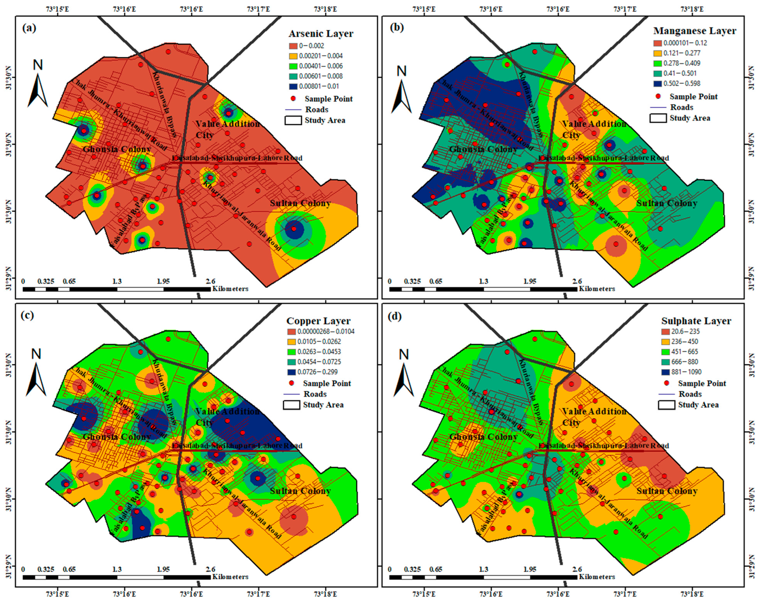
Arsenic status: Arsenic levels in groundwater samples ranged from 0 to 0.01 mg/L, with an average of 0.001 mg/L. Arsenic has a WHO permitted limit of 50 mg/L. The majority of the samples did not contain detectable levels of arsenic. Groundwater quality is acceptable in terms of arsenic pollution, as illustrated in Figure 4a.
Manganese (Mn) status: The levels of Mn in groundwater ranged from 0.001 to 0.5 mg/L, with an average mean value of 0.2 mg/L. According to WHO guidelines, the maximum allowable Mn concentration in drinking water is 0.5 mg/L. Our results revealed that the Mn values in groundwater samples were within the permissible limits in the Value Addition City. Figure 4b demonstrates that the bulk of the research region, which includes Ghousia, the Sultan Colony, and the Chak Jhumra–Khurrianwala Road, has Mn levels over the allowable limits, making the water there unsafe for human consumption.
Copper status: Copper analysis in the groundwater shows that its values varied from 0 to 0.299 mg/L with a mean value of 0.026 mg/L. Further, copper status in groundwater indicated that the entire research area was within the permissible limits of WHO, which is 1 mg/L, as shown in Table 1. Figure 4c shows that the high-concentration zone of copper is located in the Ghousia Colony and Value Addition City, having copper values of 0.0726 to 0.299 mg/L, but this concentration is within the WHO limits, and water is fit for drinking purposes.
Sulfate status: The abundance of the principal anions in the research area was in the following order: SO2 > Cl > HCO3 > CO3. The concentration of sulfate ions in the area was greater. It had a concentration range of 20 to 1090 mg/L, with an average of 441.11 mg/L (Table 1). Figure 4d depicts the geographical distribution of sulfate ion concentration in groundwater. Only 11.3% of the groundwater samples were found to be contaminated, obtained along the Sheikhupura–Lahore route, which were within the maximum permitted limit of 250 mg/L. The remaining area was above the WHO permissible limits and unfit for drinking. Most of the area of the Sultan Colony and Value Addition City was within the range of 236–450 mg/L. Areas near the Madhuana drain and Khurrianwala Bypass showed a high concentration of Sulfate ions of 666–880 mg/L.
Iron status: Water quality in the research area was also evaluated utilizing iron analysis. As indicated in Table 1, the average iron concentration in groundwater is 0.2 mg/L, with a range of 0 to 0.519 mg/L. To comply with World Health Organization standards, the Fe concentration in drinking water must be less than or equal to 0.3 mg/L. Figure 5a illustrates the spatial distribution of Fe concentration in the study region. The results indicated that the Fe level in groundwater samples was very low in the entire area except in some areas near the Ghousia Colony (i.e., 0.3–0.5 mg/L).
Chromium status: The concentration of chromium in groundwater samples from the industrial zone ranged from 0 to 0.016 mg/L. The cadmium level in the majority of the samples is below the allowable limit of 0.05 mg/L (WHO 2011). The geographical variability in chromium is depicted in Figure 5b. The first three classes on the map show that the cadmium levels in the samples over the study area are within the acceptable range. Sultan, Ghousia, and the Value Addition City have the greatest chromium level, with readings between 0.0382 and 0.106 mg/L, yet this concentration is still within WHO guidelines.
Mg and Ca status: Mg was the most prevalent cation in the research area. Its content ranged from 243 to 1070 mg/L, with a mean of 360.54 mg/L (Table 1). According to the WHO guidelines, the maximum acceptable concentration is 50 mg/L, and the entire research area was above the permitted limit. Figure 5c depicts the regional diversity in Mg ion concentrations. Mg ion concentration was high on the Faisalabad Bypass side and Sultan and Ghousia Colonies ranging from 550 to 1070 mg/L. Calcium ion concentrations were lower than magnesium ion concentrations, ranging from 28 to 232 mg/L with a mean value of 125 mg/L (Table 1). Ca levels were higher than the maximum permitted limit of 75 mg/L in 62.9% of the samples. Further spatial distribution of Ca concentration was within the permissible limit of 28–75 mg/L in the areas near the Faisalabad Bypass Road, Khurrianwala Bypass Road, and some areas of the Ghousia Colony (Figure 5d). Ca ion concentration was very high in the Sultan Colony and Value Addition City, indicating an unfit water for drinking purposes. The high total amounts of Ca and Mg in water are major elements that contribute to its hardness.

4. Discussion

Groundwater chemistry has been used for water supply forecasting in a variety of applications, including agriculture and human use [40,41,42,43,44,45,46,47,48,49,50,51]. In this research, a GIS-based water quality index (WQI) was used to determine groundwater quality in the research region since it is a helpful technique for assessing overall water quality for drinking purposes. Unlike other indices, which can only represent the water quality at a single site, our analysis has determined a localized assessment of the water quality status in a small industrial zone, which shows great spatial variability in pollutant concentration. GIS is an effective tool in which by using interpolation and some other statistical tools, results of some specific locations can be interpolated over the entire study area. Sixteen water quality parameters were determined across 60 locations in this study. Every parameter’s GIS sheet was created using the ordinary kriging estimator with a pixel size of 12 × 12 m2. Based on the perceived impact of these contaminants on human health, the criteria given a weight (wi) were assigned to each parameter ranging from 1 to 5, with 5 representing the highest weight as shown in (Table 2). Because of their relevance in determining water quality, factors such as arsenic and chromium were given a maximum weight of 5. pH, iron, and copper were all given 4 out of 5 ratings. Other parameters were given a weight of 1 to 4 based on their significance in determining water quality. The groundwater samples’ computed WQI value varied between 28 and 338. Table 3 shows the calculated water quality index values for each of the 60 water sampling locations. Lower values of WQI are seen at the G5, G12, and G20 sample sites, whereas more often, observed levels are observed at the G34, G54, and G56 locations.
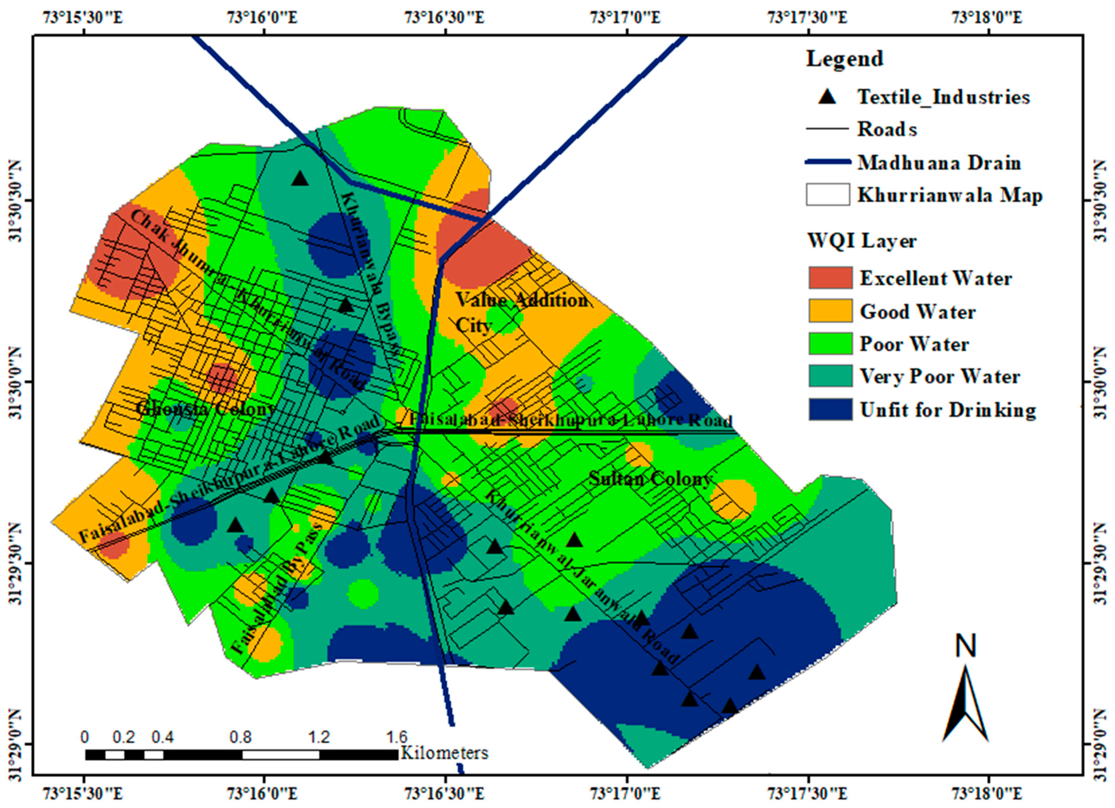
The resulting map of the WQI map made up of all parameter layers is shown in Figure 6. The resulting map showed that the water quality was fit for drinking purposes only in the Value Addition City and some areas near the Ghousia Colony. Around the wastewater outlet point of textile factories on the Khurrianwala–Jaranwala Road, Faisalabad–Sheikhupura Road, and Khurrianwala Bypass, the water quality was poorer. The major source of pollution is the Madhuana drain’s recharge mechanism, which transports 0.56 million m3/day of water. The main reason for the higher metal concentration in this area’s groundwater is that industrialization and urbanization have considerably increased the number of contaminants in the environment, which may be seeping from the soil. Heavy metals are found in water as a result of significant industries that operate at high temperatures, such as textile mills, dye textile units, spinning mills, and pharmaceutical companies. The sewage system and waste disposal are another important source of high concentrations. The resulting map can help the administration and authorities of Khurrianwala City to manage a disposal plan of sewage water into the Madhuana drain. It is overseen that only 5% of the groundwater samples represented “excellent water”, 17% represented “good water”, 32% indicated “poor water”, 29% indicated “very poor water”, and 17% water was unfit for drinking purposes (Table 4).
Keeping in view the drastic effects of inorganic pollutants in groundwater, mitigation is an economical and more effective technique as compared with treatment techniques. As aquifers and groundwater are preferred sources in the study area that are already being contaminated by a nearby industrial zone, water must be used after various treatment methods, such as membrane filtration techniques, which can remove approximately 90–99% of inorganic and organic pollutants from water. On the other hand, dissolution, mobilization, and adsorption techniques are also helpful in the removal of heavy metals. Studies have shown that remediation of heavy metals from water can be obtained by the formation of metal carbonated, ion exchange, and surface absorption techniques [52].
Continuously increasing anthropogenic activities, such as in the form of pesticide and fertilizer manufacturing and usage in industrial and agricultural areas, are also affecting groundwater quality. Therefore, there is a need for strict policies and their implication for government institutions. Several acts are already present, such as the “Agriculture Pesticide Ordinance (1971)”, but these acts are not addressing the negative impacts of these chemicals on the environment [53]. Another mitigation strategy is the introduction of a “state-led impartial water supply system” in the area. Effective working of the system can also lower the dependence of locals on groundwater reservoirs [54]. Rainwater harvesting techniques are also in practice nowadays. The introduction of such strategies will help to save water and will help in recharging groundwater resources [55].

5. Conclusions

Groundwater is a promising supply of freshwater that can be used for both irrigation and consumption. However, contamination from point and nonpoint sources induced by human activities has impaired groundwater quality in recent years, producing socioeconomic and health problems [55]. WQI is particularly efficient and effective in summarizing and providing observed effects to policy authorities to assist them in understanding the current condition of groundwater quality and provide the opportunity for future improved use. The results and analysis demonstrated the value of GIS as a tool for constructing digital thematic layers and maps that illustrate the spatial distribution of various water quality measures.
Drinking water quality in the research area has deteriorated to an alarming level. The constant release of industrial effluents from various companies, particularly those without sewage treatment systems, is thought to be the cause of heavy metal deposition in aquifers. As a result, careful planning is essential. Before release, several treatment procedures for heavy metals and other pollutants in effluents should be used. Currently, the study is only limited to groundwater quality analysis; however, more work is needed to examine the socioeconomic and health effects. Water system authorities and policymakers can use the findings of this study as a baseline for future pollutants’ prevention and groundwater management not only in the current study area but also in similar regions of Pakistan.

Author Contributions

A.S.U. planned, conducted an experiment, and analyzed data; H.R. helped in finalizing the research theme and objectives; S.N.K. guided the experimentation and reviewed the article; A.A. and M.U.A. helped in writing the results and discussion; A.A., M.M.R. and S.M. assisted in the review and editing of the manuscript. All authors have read and agreed to the published version of the manuscript.

Funding

This research received no external funding.

Institutional Review Board Statement

Not applicable.

Informed Consent Statement

Not applicable.

Data Availability Statement

Study did not report any data.

Acknowledgments

The authors acknowledge the help and support from all laboratory and field staff at the Department of Structures and Environmental Engineering, University of Agriculture, Faisalabad.

Conflicts of Interest

The authors declare no conflict of interest.

References

  1. Umar, M.; Khan, S.; Arshad, A.; Anh, D. A modified approach to quantify aquifer vulnerability to pollution towards sustainable groundwater management in Irrigated Indus Basin. Environ. Sci. Pollut. Res. 2022, 29, 27257–27278. [Google Scholar] [CrossRef] [PubMed]
  2. Saatsaz, M.; Chitsazan, M.; Eslamian, S.; Sulaiman, W.N.A. The application of groundwatermodelling to simulate the behavior of groundwaterresources in the Ramhormooz Aquifer, Iran. Int. J. Water 2011, 6, 29–42. [Google Scholar] [CrossRef]
  3. Ramamoorthy, P.; Rammohan, V. Assessment of groundwater potential zone using remote sensing and GIS in Varahanadhi watershed, Tamil Nadu, India. Int. J. Res. Appl. Sci. Eng. Technol. 2015, 3, 695–702. [Google Scholar]
  4. Ahmed, A.; Nasir, A.; Basheer, S.; Arslan, C.; Anwar, S. Ground water quality assessment by using geographical information system and water quality index: A case study of chokera, Faisalabad, Pakistan. Water Conserv. Manag. 2019, 3, 7–19. [Google Scholar] [CrossRef]
  5. Qureshi, A.S. Improving food security and livelihood resilience through groundwater management in Pakistan. Glob. Adv. Res. J. Agric. Sci. 2015, 4, 687–710. [Google Scholar]
  6. Kahlown, M.A.; Ashraf, M.; Hussain, M.; Salam, H.A.; Bhatti, A.Z. Effluents on Water Resources, Sold, Cropsand; Pakistan Council of Research in Water Resources: Hyderabad, Pakistan, 2006.
  7. Qureshi, A.S.; Gill, M.A.; Sarwar, A. Sustainable groundwater management in Pakistan: Challenges and opportunities. Irrig. Drain. 2010, 59, 107–116. [Google Scholar] [CrossRef]
  8. Li, H.; Smith, C.D.; Wang, L.; Li, Z.; Xiong, C.; Zhang, R. Combining spatial analysis and a drinking water quality index to evaluate monitoring data. Int. J. Environ. Res. Public Health 2019, 16, 357. [Google Scholar] [CrossRef] [Green Version]
  9. Nas, B.; Berktay, A. Groundwater quality mapping in urban groundwater using GIS. Environ. Monit. Assess. 2010, 160, 215–227. [Google Scholar] [CrossRef] [PubMed]
  10. Zhao, B.; Wong, Y.; Ihara, M.; Nakada, N.; Yu, Z.; Sugie, Y.; Miao, Y.; Tanaka, H.; Guan, Y. Characterization of nitrosamines and nitrosamine precursors as non-point source pollutants during heavy rainfall events in an urban water environment. J. Hazard. Mater. 2022, 424, 127552. [Google Scholar] [CrossRef]
  11. Economic and Social Commission for Asia and the Pacific. State of the Environment in Asia and the Pacific (Bangkok: United Nations ESCAP); Economic and Social Commission for Asia and the Pacific: Bangkok, Thailand, 2005. [Google Scholar]
  12. Evans, A.E.V.; Hanjra, M.A.; Jiang, Y.; Qadir, M.; Drechsel, P. Water Quality: Assessment of the Current Situation in Asia. Int. J. Water Resour. Dev. 2012, 28, 195–216. [Google Scholar] [CrossRef]
  13. Wong, Y.J.; Shimizu, Y.; He, K.; Nik Sulaiman, N.M. Comparison among different ASEAN water quality indices for the assessment of the spatial variation of surface water quality in the Selangor river basin, Malaysia. Environ. Monit. Assess. 2020, 192, 644. [Google Scholar] [CrossRef] [PubMed]
  14. Nasir, M.S.; Nasir, A.; Rashid, H.; Shah, S.H.H. Spatial variability and long-term analysis of groundwater quality of Faisalabad industrial zone. Appl. Water Sci. 2017, 7, 3197–3205. [Google Scholar] [CrossRef]
  15. Pakistan Council of Research in Water Resources (PCRWR). Water Quality Status of Pakistan, Fifth Monitoring Report 2005–2006. In National Water Quality Monitoring Programme; Pakistan Council of Research in Water Resources: Hyderabad, Pakistan, 2007; p. 133. [Google Scholar]
  16. Solangi, G.S.; Siyal, A.A.; Babar, M.M.; Siyal, P. Evaluation of surface water quality using the water quality index (Wqi) and the synthetic pollution index (spi): A case study of indus delta region of pakistan. Desalin. Water Treat. 2018, 118, 39–48. [Google Scholar] [CrossRef]
  17. Wong, Y.J.; Nakayama, R.; Shimizu, Y.; Kamiya, A.; Shen, S.; Rashid, I.Z.M.; Sulaiman, N.M.N. Toward industrial revolution 4.0: Development, validation, and application of 3D-printed IoT-based water quality monitoring system. J. Clean. Prod. 2021, 324, 129230. [Google Scholar] [CrossRef]
  18. Verma, P.; Singh, P.K.; Sinha, R.R.; Tiwari, A.K. Assessment of groundwater quality status by using water quality index (WQI) and geographic information system (GIS) approaches: A case study of the Bokaro district, India. Appl. Water Sci. 2020, 10, 27. [Google Scholar] [CrossRef] [Green Version]
  19. Murasingh, S. Analysis of Groundwater Potential Zones Using Electrical Resistivity, RS and GIS Techniques in a Typical Mine Area of Odisha. Master’s Thesis, Department of Civil Engineering National Institute of Technology, Rourkela, India, 2014. [Google Scholar]
  20. Mahmood, A.; Muqbool, W.; Mumtaz, M.W.; Ahmad, F. Application of multivariate statisticaltechniques for the characterization of groundwaterquality of Lahore, Gujranwala and Sialkot (Pakistan). Pak. J. Anal. Environ. Chem. 2011, 12, 102–112. [Google Scholar]
  21. Arkoç, O. Application of water quality index with the aid of geographic information system in eastern thrace to assess groundwater quality. Jeol. Mühendisliği Derg. 2016, 40, 189–208. [Google Scholar]
  22. Imtiaz, F.; Ahmad, I.; Ahmad, S.R. Gis based evaluation of groundwater quality of western lahore using water quality index. Pak. J. Agric. Sci. 2018, 55, 653–665. [Google Scholar]
  23. Balakrishnan, P. Groundwater quality mapping using geographic information system (GIS): A case study of Gulbarga City, Karnataka, India. Afr. J. Environ. Sci. Technol. 2011, 5, 1069–1084. [Google Scholar] [CrossRef]
  24. Shabbir, R.; Ahmad, S.S. Use of Geographic Information System and Water Quality Index to Assess Groundwater Quality in Rawalpindi and Islamabad. Arab. J. Sci. Eng. 2015, 40, 2033–2047. [Google Scholar] [CrossRef]
  25. State, A. Groundwater Quality Mapping using GIS: A Case Study of Awka, Anambra state, Nigeria. Int. J. Eng. Manag. Res. 2016, 6, 579–584. [Google Scholar]
  26. APHA. Standard Methods for the Examination of Water and Wastewater, 20th ed.; Method. 5210 B; American Public Health Association: Washington, DC, USA, 2003. [Google Scholar]
  27. Greenberg, A.E.; Clesceri, L.S.; Eaton, A.D. Standard Methods for the Examination of Water and Wastewater; American Public Health Association: Washington, DC, USA, 1992. [Google Scholar]
  28. Boah, D.K.; Twum, S.B.; Pelig-Ba, K.B. Mathematical computation of water quality index of Vea dam in upper east Region of Ghana. Environ. Sci. 2015, 3, 11–16. [Google Scholar] [CrossRef] [Green Version]
  29. Mutasher, A.K.A.; Al-Mohammed, F.M.; Aljibori, H.S.S. Groundwater quality assessment for irrigation purpose using water quality index in Green Belt project in Karbala city—Iraq. J. Eng. Sci. Technol. 2021, 16, 4060–4078. [Google Scholar]
  30. Fernandez, F.J.; Kahn, H.L. Clinical Methods for Atomic Absorption Spectrophotometry. Clin. Chem. Newsl. 1971, 3, 34. [Google Scholar]
  31. Vaiphei, S.P.; Kurakalva, R.M.; Sahadevan, D.K. Water quality index and GIS-based technique for assessment of groundwater quality in Wanaparthy watershed, Telangana, India. Environ. Sci. Pollut. Res. 2020, 27, 45041–45062. [Google Scholar] [CrossRef] [PubMed]
  32. Adimalla, N. Groundwater quality for drinking and irrigation purposes and potential health risks assessment: A case study from semiarid region of South India. Expo. Health 2019, 11, 109–123. [Google Scholar] [CrossRef]
  33. Kumar, S.K.; Logeshkumaran, A.; Magesh, N.S.; Godson, P.S.; Chandrasekar, N. Hydrogeochemistry and application of water quality index (WQI) for groundwater quality assessment, Anna Nagar, part of Chennai City, Tamil Nadu, India. Appl. Water Sci. 2015, 5, 335–343. [Google Scholar] [CrossRef] [Green Version]
  34. Chaurasia, A.K.; Pandey, H.K.; Tiwari, S.K.; Prakash, R.; Pandey, P.; Ram, A. Groundwater quality assessment using water quality index (WQI) in parts of Varanasi District, Uttar Pradesh, India. J. Geol. Soc. India 2018, 92, 76–82. [Google Scholar] [CrossRef]
  35. Yang, R.; Xing, B. A Comparison of the Performance of Different Interpolation Methods in Replicating Rainfall Magnitudes under Different Climatic Conditions in Chongqing Province (China). Atmosphere 2021, 12, 1318. [Google Scholar] [CrossRef]
  36. Alqarawy, A.; El Osta, M.; Masoud, M.; Elsayed, S.; Gad, M. Use of Hyperspectral Reflectance and Water Quality Indices to Assess Groundwater Quality for Drinking in Arid Regions, Saudi Arabia. Water 2022, 14, 2311. [Google Scholar] [CrossRef]
  37. Tiwari, A.K.; Kumar, S.A.; Kumar, S.A.; Singh, M.P. Hydrogeochemical analysis and evaluation of surface water quality of Pratapgarh district, Uttar Pradesh, India. Appl. Water Sci. 2017, 7, 1609–1623. [Google Scholar] [CrossRef] [Green Version]
  38. Zolekar, R.B.; Todmal, R.S.; Bhagat, V.S.; Bhailume, S.A.; Korade, M.S.; Das, S. Hydrochemical characterization and geospatial analysis of groundwater for drinking and agricultural usage in Nashik district in Maharashtra, India. Environ. Dev. Sustain. 2020, 23, 4433–4452. [Google Scholar] [CrossRef]
  39. Sakaa, B.; Elbeltagi, A.; Boudibi, S.; Chaffaï, H.; Islam, A.R.M.; Kulimushi, L.C.; Choudhari, P.; Hani, A.; Brouziyne, Y.; Wong, Y.J. Water quality index modeling using random forest and improved SMO algorithm for support vector machine in Saf-Saf river basin. Environ. Sci. Pollut. Res. 2022, 29, 48491–48508. [Google Scholar] [CrossRef] [PubMed]
  40. Mansouri, Z.; Leghrieb, Y.; Kouadri, S.; Al-Ansari, N.; Najm, H.M.; Mashaan, N.S.; Eldirderi, M.M.A.; Khedher, K.M. Hydro-Geochemistry and Groundwater Quality Assessment of Ouargla Basin, South of Algeria. Water 2022, 14, 2441. [Google Scholar] [CrossRef]
  41. Ma, Z.; Li, J.; Zhang, M.; You, D.; Zhou, Y.; Gong, Z. Groundwater Health Risk Assessment Based on Monte Carlo Model Sensitivity Analysis of Cr and As—A Case Study of Yinchuan City. Water 2022, 14, 2419. [Google Scholar] [CrossRef]
  42. Ye, X.; Zhou, Y.; Lu, Y.; Du, X. Hydrochemical Evolution and Quality Assessment of Groundwater in the Sanjiang Plain, China. Water 2022, 14, 1265. [Google Scholar] [CrossRef]
  43. Singh, R.; Upreti, P.; Allemailem, K.S.; Almatroudi, A.; Rahmani, A.H.; Albalawi, G.M. Geospatial Assessment of Ground Water Quality and Associated Health Problems in the Western Region of India. Water 2022, 14, 296. [Google Scholar] [CrossRef]
  44. Nsabimana, A.; Li, P.; He, S.; He, X.; Alam, S.M.K.; Fida, M. Health Risk of the Shallow Groundwater and Its Suitability for Drinking Purpose in Tongchuan, China. Water 2021, 13, 3256. [Google Scholar] [CrossRef]
  45. Lalumbe, L.; Kanyerere, T. Characterisation of Hydro-Geochemical Processes Influencing Groundwater Quality in Rural Areas: A Case Study of Soutpansberg Region, Limpopo Province, South Africa. Water 2022, 14, 1972. [Google Scholar] [CrossRef]
  46. El Osta, M.; Masoud, M.; Alqarawy, A.; Elsayed, S.; Gad, M. Groundwater Suitability for Drinking and Irrigation Using Water Quality Indices and Multivariate Modeling in Makkah Al-Mukarramah Province, Saudi Arabia. Water 2022, 14, 483. [Google Scholar] [CrossRef]
  47. Reyes-Toscano, C.A.; Alfaro-Cuevas-Villanueva, R.; Cortés-Martínez, R.; Morton-Bermea, O.; Hernández-Álvarez, E.; Buenrostro-Delgado, O.; Ávila-Olivera, J.A. Hydrogeochemical Characteristics and Assessment of Drinking Water Quality in the Urban Area of Zamora, Mexico. Water 2020, 12, 556. [Google Scholar] [CrossRef] [Green Version]
  48. Liu, F.; Zhao, Z.; Yang, L.; Ma, Y.; Li, B.; Gong, L.; Liu, H. Phreatic Water Quality Assessment and Associated Hydrogeochemical Processes in an Irrigated Region Along the Upper Yellow River, Northwestern China. Water 2020, 12, 463. [Google Scholar] [CrossRef] [Green Version]
  49. Haider, H.; Ghumman, A.R.; Al-Salamah, I.S.; Thabit, H. Assessment Framework for Natural Groundwater Contamination in Arid Regions: Development of Indices and Wells Ranking System Using Fuzzy VIKOR Method. Water 2020, 12, 423. [Google Scholar] [CrossRef] [Green Version]
  50. Wang, L.; Mei, Y.; Yu, K.; Li, Y.; Meng, X.; Hu, F. Anthropogenic Effects on Hydrogeochemical Characterization of the Shallow Groundwater in an Arid Irrigated Plain in Northwestern China. Water 2019, 11, 2247. [Google Scholar] [CrossRef] [Green Version]
  51. Haider, H.; Alkhowaiter, M.H.; Shafiquzzaman, M.; AlSaleem, S.S.; Almoshaogeh, M.; Alharbi, F. Spatiotemporal Water Quality Variations in Smaller Water Supply Systems: Using Modified CCME WQI from Groundwater Source to Distribution Networks. Water 2019, 11, 1884. [Google Scholar] [CrossRef] [Green Version]
  52. Kurwadkar, S.; Kanel SRNakarmi, A. Groundwater pollution: Occurrence, detection, and remediation of organic and inorganic pollutants. Water Environ. Res. 2020, 92, 1659–1668. [Google Scholar] [CrossRef]
  53. Agriculture Pesticide Ordinance. 1970. Available online: https://senate.gov.pk/uploads/documents/1658381597_805.pdf (accessed on 5 October 2022).
  54. Altaf, S. Sustainable Urban Groundwater Governance in Faisalabad, Pakistan: Challenges and Possibilities. Ph.D. Thesis, University of Louisville, Louisville, KY, USA, 2021. [Google Scholar] [CrossRef]
  55. Sajjad, M.M.; Wang, J.; Abbas, H.; Ullah, I.; Khan, R.; Ali, F. Impact of Climate and Land-Use Change on Groundwater Resources, Study of Faisalabad District, Pakistan. Atmosphere 2022, 13, 1097. [Google Scholar] [CrossRef]
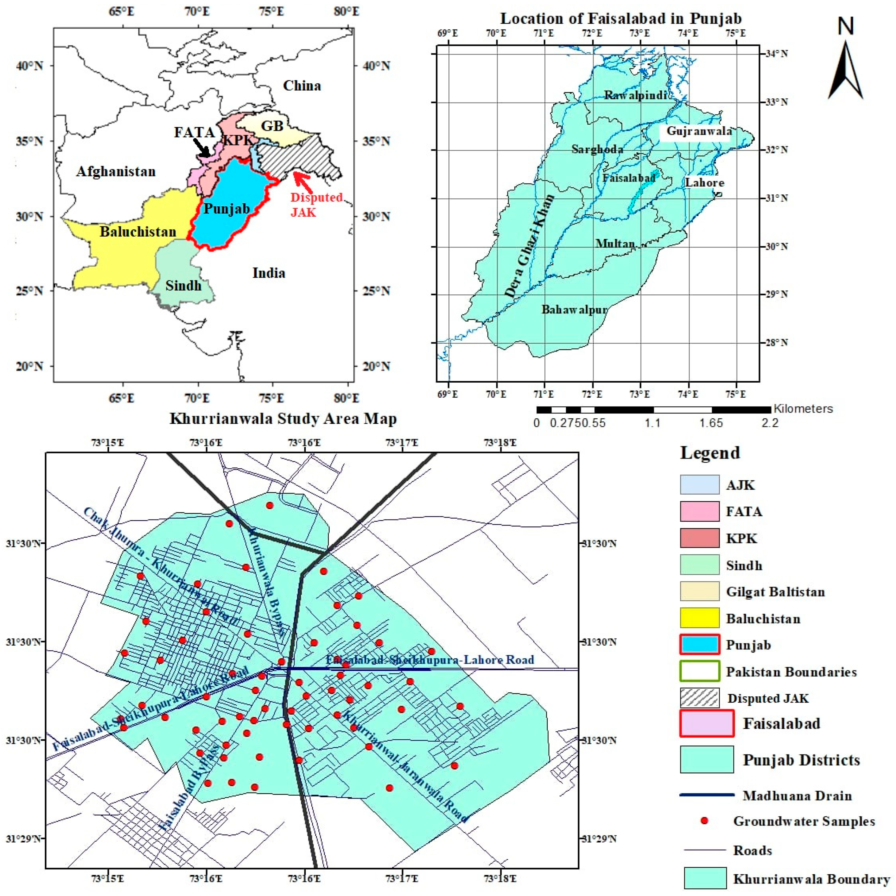
Figure 1. Geographical location of the Faisalabad district in Pakistan and experimental location of the Khurrianwala industrial zone and sampling sites.
Water 14 03342 g001
Figure 2. Spatial variability of pH (a), EC (b), carbonate (c), and bicarbonate (d) in groundwater.
Water 14 03342 g002
Figure 3. Spatial variability of TSS (a), TDS (b), turbidity (c), and chloride (d) in groundwater.
Water 14 03342 g003
Figure 4. Spatial variability of As (a), Mn (b), Cu (c), and sulfate (d) in groundwater.
Water 14 03342 g004
Figure 5. Spatial variability of Fe (a), Cr (b), Mg (c), and Ca (d) in groundwater.
Water 14 03342 g005
Figure 6. Spatial distribution of WQI along with textile industries’ locations in the study Area.
Water 14 03342 g006
Table 1. Statistical results of different parameters tested in the groundwater samples.
Water Quality ParameterUnitsMinimumMaximumMeanWHO Standard Values
TDS(mg/L)971266017941000
TSS(mg/L)40.320098.4120
pH-6.57.627.077
EC(μS */cm)194053203581197.14
Mn(mg/L)0.00010.5980.3560.5
Cl(mg/L)172898557250
As(mg/L)00.010.00150
Fe(mg/L)8.82 × 10−70.5190.04800.3
Sulfate(mg/L)20.61090484250
Turbidity(NTU **)1.37 × 10−550.3555
Bicarbonate(mg/L)377830519120
Ca(mg/L)2823286.8675
Mg(mg/L)243107049450
Cu(mg/L)2.68 × 10−60.2990.04791
Carbonate(mg/L)00060
Cr(mg/L)3.99 × 10−60.1060.050.05
* μS stands for microsiemens. ** NTU stands for nephelometric turbidity unit.
Table 2. WHO standard values, estimated weight, and relative weight of several parameters.
Water Quality ParameterWHO Standard ValueAssigned WeightRelative Weightage
TDS (mg/L)100030.058
TSS (mg/L)12030.058
pH740.078
EC (μS/cm)197.1430.058
Mn (mg/L)0.530.058
Cl (mg/L)25030.058
As (mg/L)5050.098
Fe (mg/L)0.340.078
Sulfate (mg/L)25030.058
Turbidity (NTU)520.039
Bicarbonate (mg/L)12020.039
Ca (mg/L)7520.039
Mg (mg/L)5020.039
Cu (mg/L)140.078
Carbonate (mg/L)6030.058
Cr (mg/L)0.0550.098
Total ∑wi = 511
Table 3. Calculation of the water quality index for individual water samples.
Samples 1–20WQI ValueSamples 20–40WQI ValueSample 40–60WQI Value
G1168.98G21143.98G41182.98
G2166.59G22232.4G42179.94
G3162.73G23173.16G43174.86
G4172.17G24208.94G44171.26
G5125.38G25160.07G45179.38
G6184.79G26193.86G46179.99
G7186.43G27162.57G47181.7
G8169.73G28200.77G48191.73
G9221.22G29231.62G49182.95
G10199.26G30222.12G50178.45
G11177.96G31179.75G51218.6
G12110.32G32155.84G52209.38
G13164.38G33144.08G53196.73
G14181.04G34234.65G54247.09
G15166.18G35155.42G55168.13
G16173.13G36209.12G56243.09
G17223.11G37184G57227.33
G18191.17G38229.55G58207.04
G19184.58G39186.64G59167.95
G20133.85G40211.84G60195.93
Table 4. WQI and water grading standards.
SR.WQI RangeType of Water% Area in Each Class
1.<50Excellent water5
2.50–100Good water17
3.100–200Poor water32
4.200–300Very poor water29
5.>300Unfit for drinking17
Publisher’s Note: MDPI stays neutral with regard to jurisdictional claims in published maps and institutional affiliations.