Article

Simulation-Optimization of Tarbela Reservoir Operation to Enhance Multiple Benefits and to Achieve Sustainable Development Goals

by
Muhammad Mohsin Munir
1,
Abdul Sattar Shakir
1,
Habib-Ur Rehman
1,
Noor Muhammad Khan
1,
Muhammad Usman Rashid
2,
Muhammad Atiq Ur Rehman Tariq
3,4,* and
Muhammad Kaleem Sarwar
5
1
Civil Engineering Department, University of Engineering & Technology, Lahore 54890, Pakistan
2
Civil Engineering Department, University of Management & Technology, Lahore 54770, Pakistan
3
College of Engineering, IT & Environment, Charles Darwin University, Darwin, NT 0810, Australia
4
Institute for Sustainable Industries & Liveable Cities, Victoria University, PO Box 14428, Melbourne 8001, Australia
5
Centre of Excellence in Water Resources, University of Engineering & Technology, Lahore 54890, Pakistan
*
Author to whom correspondence should be addressed.
Water 2022, 14(16), 2512; https://doi.org/10.3390/w14162512
Submission received: 17 June 2022 / Revised: 8 August 2022 / Accepted: 12 August 2022 / Published: 15 August 2022
(This article belongs to the Section Water Use and Scarcity)

Abstract

:
Pakistan’s agriculture and economy rely heavily on the Tarbela Reservoir. The present storage capacity of Tarbela is 8.2 BCM and it has been depleted by more than 40% due to sedimentation since 1976. It also has had a 0.94 percent (0.134 BCM) decrease in gross reservoir capacity every year. Historically, the amount of sediment trapped in the Tarbela Reservoir during the period 1976–2020 was 198.5 million tonnes annually. Based on the current operation by the Water and Power Development Authority (WAPDA), the delta is expected to extend to 2.41 km from the dam in 2035. The reservoir will become a run-of-the-river reservoir with a gross storage capacity of 2.87 BCM. This rapid loss of storage capacity will significantly impact reservoir benefits while also putting turbine performance at risk due to abrasion. Slowing the sediment deposition phenomena by a flexible operational strategy is a worthwhile aim from the dam manager’s viewpoint to achieve Sustainable Development Goals (i.e., poverty and hunger alleviation, clean affordable energy, protecting ecosystem etc.). Therefore, for the safe and long-term operation of the turbines, the existing Standard Operating Procedures (SOPs) adopted by WAPDA need to be appraised to delineate their impact on future optimized operations. The aspect of considering static SOPs on the whole period of reservoir operation has not been attempted earlier. The Tarbela Reservoir was selected as a case study to enhance the existing reservoir operation. The methodology relies upon the use of a 1-D sediment transport model in HEC-RAS to study the impact of the operational strategy on sedimentation. In conjunction, the existing reservoir operation of Tarbela was modelled in HEC-ResSim using its physical, operational, and 10-daily time-series data for simulation of releases and hydropower benefits based on a revised elevation-capacity curve for sedimentation. After calibration and validation, the model was applied to predict future reservoir operation impacts on a 5-year basis from 2025 to 2035 for determining storage capacity, irrigation releases, power production and energy generation. It was predicted that as the storage capacity of the reservoir is depleted (by application of the WAPDA current SOPs in future years), the irrigation releases would be increased in the Kharif season (April–September) by 7% and decreased by 50% in the Rabi season (October–March) with a corresponding increase in power generation by 4% and decrease by 37%, respectively, and the average annual energy generation would be decreased by 6.5%. The results showed that a gradual increase in the minimum operating level will slow down delta movement but it will reduce irrigation releases at times of high demand. The findings may assist water managers to improve the Tarbela Reservoir operation to achieve sustainable development goals and to attain societal future benefits.

1. Introduction

Reservoir development helps the entire world satisfy its food and fibre demands by providing water for agriculture and hydropower, generating rapid monetary growth, and enabling flood management. Simultaneously, current reservoir storage capacities are dwindling worldwide, posing a hazard to agricultural and hydropower generation. With mean yearly reservoir storage capacity reductions ranging from 0.1% to 2.3% owing to sedimentation, there is a scarcity of accurate data on reservoir sedimentation rates worldwide. Despite this, the global annual storage loss is approximately 1.0% [1].
Storage loss in China’s largest reservoir is 2.3%, while the lowest storage loss in the UK is 0.1% [1]. According to the International Commission on Large Dams, there are over 42,000 big dams in the world [2], and the global rate of storage loss and storage capacity owing to sedimentation concerns is around 0.5% to 1% and 7000 km3 annually, respectively. In 2015, 50 km3 of storage capacity was added worldwide annually to compensate for this loss rate, costing over 18 billion dollars [3]. A global crisis of water availability may occur, if communities continue to allow reservoir storage capacity to reduce [4]. The world’s ever-increasing population exacerbates the problem. Although, worldwide, storage volume diminishes, water storage requirements increase as the population expands [5]. Due to a decline in dam construction rate and sedimentation of reservoirs, there is a net reservoir storage capacity deficit [6].
In Venezuela, an extreme event occurred within 15 years of the reservoir operation starting, when the available storage capacity of the Camaré reservoir was lost due to sedimentation [7]. The storage capacity of Zuni Dam in New Mexico declined by 20% of the designed capacity within 25 years of operation commencement. Most of the dams in the United States west of the Mississippi River have yearly sedimentation rates of more than 1.2 percent, with storage loss rates of more than 2 percent in most states [8]. As gross storage decreases, net irrigation releases and production from the reservoir decrease.
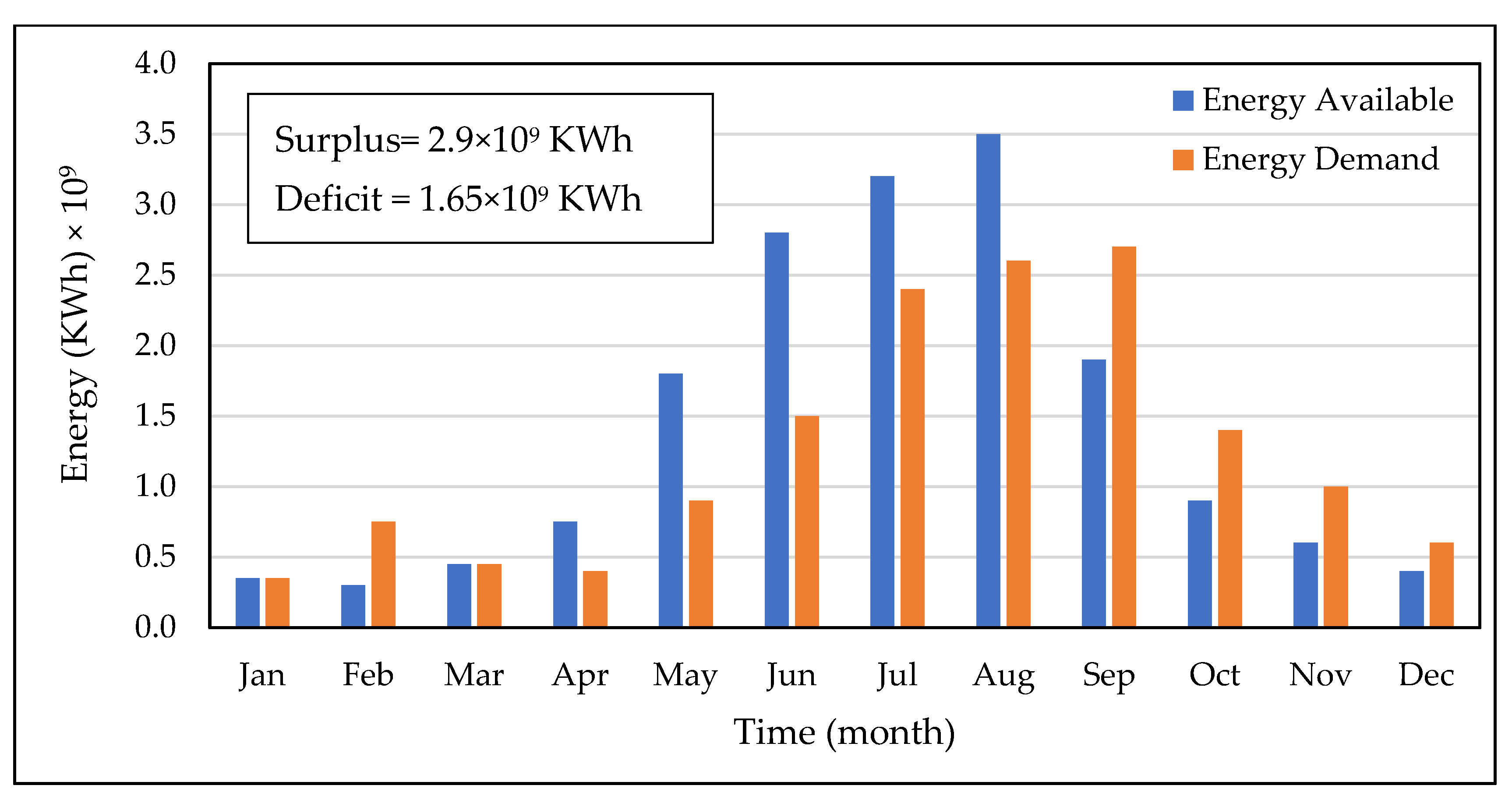
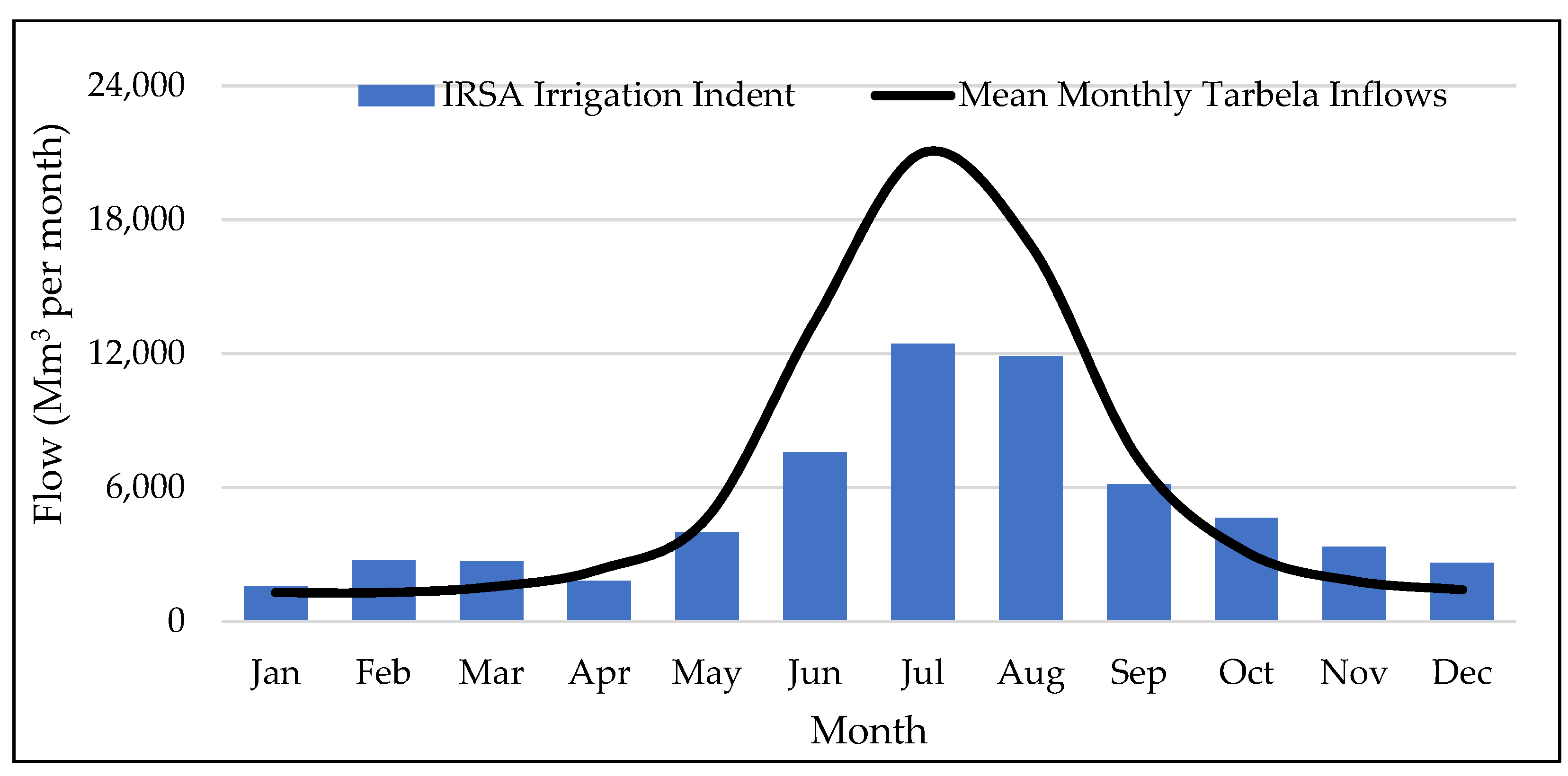
Tarbela is an important part of Pakistan’s Indus Basin plan, which intends to provide better and more consistent water to millions of acres of fertile land, hydroelectricity generation, and flood management. It is one of the world’s most important water resource development projects. The dam is located on the Indus River supplementing 50% of the country’s total food basket and making a 30% contribution to the overall energy benefit. The releases, power production, and durations will decrease with time due to the formation of a massive silt delta in the reservoir. The passage of irrigation water via the tunnels with turbines generates electricity from the Tarbela reservoir, which is Tarbela’s secondary priority. Since construction, however, the energy gains have outweighed the irrigation benefits. The plant is used to provide a base load from early June to October (when considerable, regular discharges occur) and as a peaking supply for the rest of the year. The monthly irrigation and electrical consumption curves from the Tarbela Reservoir are depicted in Figure 1 and Table 1 [9].
The capacity of the Tarbela Reservoir in Pakistan was reduced by 20% during the first two decades of its operation because the dam traps a huge amount of sediment from the Indus River [3]. It has now declined by one-third in 40 years [10]. Modelling of the associated sediment [11] was used to investigate the amount of sediment deposited in the reservoir and the dynamics of the sediment delta as it changes shape and position with incoming flows (in the past as well as in the future). According to these studies, unless remedial action (such as the current study) is taken, the reservoir’s dead and live storage will be largely filled by 2030, with a gradual reduction in the reservoir’s regulated production up to that date, and the intakes will be blocked well before [12].
The Tarbela Reservoir serves as a vital water source for irrigation, flood control, and power generation. The reservoir’s initial capacity has been reduced by 39.04 percent due to sediments [13]. When the Tarbela Reservoir was constructed in 1974, it had a gross storage capacity of 14.34 BCM and a live storage capacity of 11.94 BCM. subsequent reductions have seen the gross and live storage capacities drop to 8.74 BCM and 7.61 BCM, respectively, in 2017 [14].
Sedimentation is diminishing reservoir capacity globally. Annual global reservoir storage capacity losses range from 0.1 to 2.3 percent, with an average of around 1.0 percent. With a mean annual sediment deposition rate of 0.134 BCM/annum, the Tarbela reservoir’s gross storage capacity diminishes by the day [14].
The Tarbela Reservoir annually accumulates around 200 million tonnes of sediments (550,000 tonnes per day on average). The sediment delta pivot point is advancing towards the dam at a rate of roughly 0.386 km per year, according to current reservoir operations. The Tarbela Dam is a key component of the “Indus Basin Water Treaty” alternative works program, which began in 1960. The Tarbela Reservoir stores water from a 169,650-square-kilometre upper catchment area [15]. The Tarbela Dam, with four units generating 700 MW of energy, was completed in 1974. In 1982, four units were added to the power plant, increasing its capacity from 4 to 8 units. Two more 350 MW units, 9 and 10, were constructed in 1985, followed by four 1728 MW units 11–14 in 1992–1993, giving the Tarbela Reservoir a total generation capacity of 3478 MW [16,17,18,19]. For agricultural reasons, the Tarbela Reservoir releases 75.10 BCM of water. The Tarbela Reservoir is the main component of IBIS. During low-flow seasons, it is crucial to meet irrigation demand [20]. The reservoir will be full of sediment by the year 2030 if the current sedimentation trend continues, and the sediment delta will be close to the dam face. The expected sediment inflow rate in the reservoir was 0.294 BCM per year [20] meaning that sediment will fill the Tarbela Reservoir storage volume to 90% in 50 years. Subsequently, the reservoir will only provide 1.2 BCM of live storage.
By following WAPDA’s current operating procedures, the delta is progressing rapidly towards the dam body. The sediment delta pivot point is moving at a rate of 0.386 km/year and is now at a distance of 8.77 km and a height of 422.026 m. Tarbela’s minimum pool level was 396.3 metres at completion, and it is now maintained at 422.8 metres in 2017 [14]. According to the Pakistan WAPDA, spills (uncontrolled discharges) account for 70% of water discharge and do not generate energy [21]. This is concerning because Pakistan’s energy demands are increasing at a 7.9% annual rate (Tarbela now produces 30% of the country’s hydropower). Uncontrolled releases (when the Indus River’s flow surpasses 11,326 m3/s) have also resulted in 13 floods, causing significant damage to the agriculture industry.
The operation of the Tarbela Reservoir is based on a criterion of minimization of the irrigation release deficit. This use of a single criterion is a common approach employed globally but has limitations regarding the strengths and weaknesses of reservoir operations [22,23]. The dam is situated in a region vulnerable to the impact of climate change due to precipitation and snowmelt variability [24,25,26]. Previous research has indicated that climate change impact may shift the of peak inflow event to an earlier time [27]. If such conditions prevailed, the reservoir filling would have to be initiated earlier to attenuate flood peaks. Other research has indicated that climate change may change the crop sowing pattern to an earlier month to achieve maximum yield [28]. Early reservoir irrigation releases and a similarly limited storage volume for the falling limb would be required for this shift in sowing patterns. Due to a low storage coefficient of 0.11 (ratio of live storage to mean annual inflows) and a high draft ratio of 0.97 (ratio of annual demands to mean annual inflows), climate change, in addition to the operational stressors mentioned above, places additional strain on Tarbela Reservoir’s physical aspects [21]. Because of its low storage coefficient, the reservoir’s ability to control excessive hydrological flow fluctuation is limited.
In the 1980s, WAPDA tried to develop a decision support tool, the Indus Basin Model (IBM), for the assessment of the system’s performance aiming for maximization of net economic benefit from agriculture. However, it did not take into account the impact of standard operating procedure on long term releases and hydropower benefits [29]. In addition, previous Tarbela research has mostly concentrated on rule curve optimization approaches for improving reservoir performance [30]. For example, using a genetic algorithm for multi-objective optimization to minimize the irrigation shortfall in Tarbela. This research anticipated a low reservoir level for all months except August and September (as opposed to the present rule curve). Although this strategy reduced the irrigation deficit by a little amount (1.23 km3), there was no improvement in hydropower generation or flood damage mitigation [31]. Taking a similar irrigation-centric rule curve optimization technique recommended lowering the minimum reservoir level from 417 to 396 m. Because Tarbela was built to optimize irrigation deficits, the primary justification for this technique was that rule curves resulting from irrigation deficit reduction should be preferred. To date, no research has been done to inspect the potential effects of modifying the physical reservoir features and evaluating the existing WAPDA Standard Operating Procedures (SOPs) on the future irrigation release patterns and their multiple benefits. The present study primarily emphasizes different operational strategies for a reservoir to manage sediments for the determination of future release hydrographs along with power and energy benefits through optimal utilization coupled with the impact of existing static SOPs on the long-term operation of the reservoir. As a case study, we selected the Tarbela Reservoir in Pakistan. The generation of future optimized release patterns and power benefits were tried. Further, the impact of existing the Standard Operating Procedures (SOPs) on future reservoir operation was assessed, which was not done in earlier studies [30,31].
Simulation of reservoir operation can be efficiently carried out using HEC-ResSim computer model [32]. Assessment of the Jiroft storage dam, Iran, used the HEC-ResSim model. It was concluded that the present system of operation led to serious deficiency and failures in 25% of the operation periods, which could be mitigated by enhancement of irrigation efficiency from 30% to 50% increasing the system resilience by 17% [33]. To optimize hydropower generation and flood management, HEC-Res-Sim modelling was employed to simulate cascade dams across the Omo Gibe River basin. New operation rules were selected which increased the energy generation by 28–45% [34]. The HEC-ResSim model performed hydrologic routing and determined multiple benefits for the Kajakai reservoir in Afghanistan [35]. The HEC-ResSim model was developed for the Lancang Cascade to determine the influence of the cascade on the Lower Mekong River [36]. The HEC-ResSim model was developed for the Mosul dam to simulate the operational behaviour of the reservoir. It was found that the real operation using the current rule curve did not match the original design operating curve [37]. The HEC-ResSim model was used for the Tucuruí Dam located in Brazil. The rules for different zones of the reservoir were assessed based on the capacity of the spillways, the reservoir storage and the flow capacity of the river drainage system downstream [38].
In the Pakistani context, HEC-ResSim was employed for reservoir simulation modelling to study the impact of climate change on the hydropower generation for the Mangla reservoir. As the Mangla reservoir was raised by 12 m in the year 2009, the model was set up for two scenarios, i.e., pre-raising and post raising. Based on the simulations , it was concluded that in future the increase in annual hydropower generation was expected to be 16.6 to 20.4 percent for the pre-raising scenario and 13 to 15.3 percent increase for post-raising scenario. The developed model lacked the capability for updating the elevation capacity relationship caused by long term sedimentation in the reservoir [39].
The numerical model HEC-RAS was employed for the Tarbela Reservoir, Pakistan for the assessment of sedimentation for future operations. It was concluded that the life of reservoir may be extended by 27 years by decreasing the minimum operating level from 457 m to 401 m. However, the study did not estimate the impact on hydropower generation for future scenarios [40]. A GA-based optimization model was developed for maximization of hydropower generation for cascade reservoirs and applied to the Tarbela and Bahsa dams in Pakistan. It was concluded that average annual benefits from hydropower generation can be maximized up to 2724.7 Million US$ by the joint operation of the Tarbela and Bahsa dams [41]. The impact on hydropower generation by varying the operation of the Tarbela Reservoir was carried out using the Evaluation and Planning (WEAP) model. It was concluded that a 13% increase in hydropower generation would be expected. However, the study did not cover the impact of sedimentation for future operational strategies [42].
To achieve plan 2030, global goals or the Sustainable Development Goals (SDGs) have been developed by UNDP in 2015 to mitigate poverty and protection of the planet. Out of 17 SDGs, some of them are covered by efficient, innovative use of the reservoir operation, which include poverty and hunger alleviation, clean and affordable energy, protecting ecosystem from degradation [43]. Use of an efficient operation regarding sedimentation will alleviate food and energy issues along with other socio-economic benefits.
Owing to variability in sediment deposition in the reservoir, the physical condition in the reservoir will fluctuate, which will affect the reservoir operation, power production in peak hours, and hydropower generation. Rapid variation in seasonal high flow and reservoir levels will require new restrictions in operation of the reservoir system. Otherwise, they may have major impacts on power plant machinery and physical components of the dam, like the spillways, power, and irrigation tunnels, and the downstream river conditions and reservoirs. The latter is a new aspect that has been considered in this study. Therefore, determining the most suitable operational strategy based on the reservoir’s physical condition, considering the sediment deposition rate, is a worthwhile aim from the dam manager’s viewpoint. Hence, for the efficient operation of the reservoir, there is a need to explore future optimized reservoir’s operation to gauge future storage, irrigation releases, and power and energy production to achieve sustainable development goals. These include poverty alleviation, clean and economic energy, efficient irrigation, the use of innovative techniques, and preservation of the ecosystem.
The paper aims to review and appraise the existing operation of the Tarbela Reservoir; to carry out an assessment of optimal future irrigation outflows; to optimize the likely future power production and energy benefits and to inspect the impact of the WAPDA static SOPs on the future optimized operation, bearing in mind the time-based reservoir sedimentation and other physical constraints. To accomplish this task, the HEC-RAS 1-D sediment transport model was set up along with the HEC-ResSim reservoir operation model. The prediction of the optimized future operation was assessed on a 5-year basis from 2025 to 2035 for determining storage capacity, irrigation releases, power production and energy generation. Further, the impacts of the operational strategy during Kharif (April to September) and Rabi (October-March) irrigation releases were predicted for future application years along with the impact on reservoir capacity upon sedimentation. The outcome may assist water managers to improve the Tarbela Reservoir operation for its sustainable use to attain future societal benefits. Further, the optimum operation of the reservoir is necessary to achieve sustainable development goals, i.e., poverty and hunger alleviation, clean and affordable energy, protecting ecosystem from degradation.

2. Study Area

2.1. Description of the Case Study

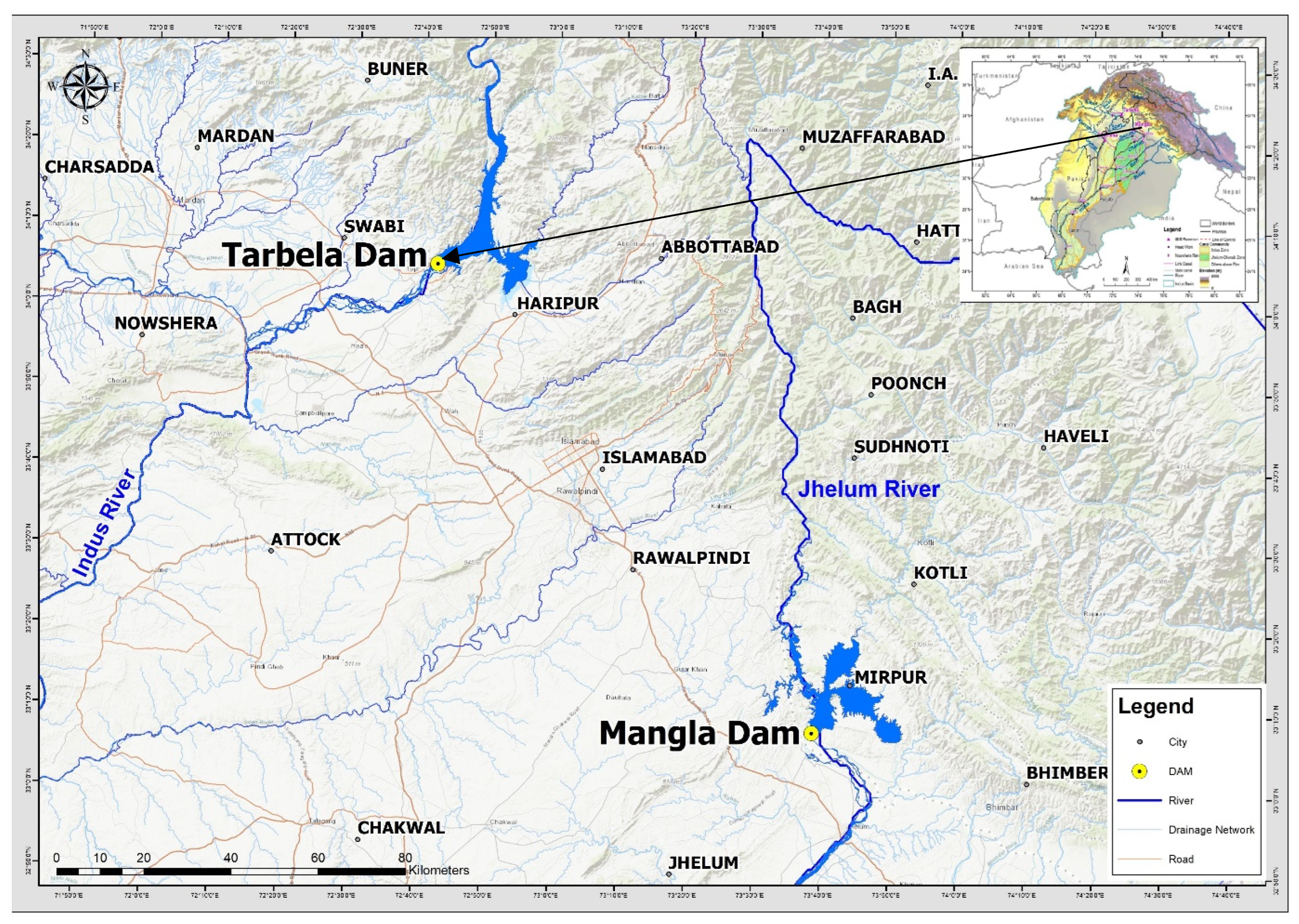
Tarbela Reservoir spans a major portion of the Indus Basin, ensuring a more reliable and consistent water supply for millions of acres of arable land, hydroelectricity generation, and flood control. The Indus catchment area at Tarbela is 169,600 km2, with a mean annual flow of only 79 BCM [44] as shown in Figure 2. It is the world’s largest earth-fill dam and Pakistan’s most important national resource. This dam on the Indus River creates a vast multipurpose reservoir that will supply half of Pakistan’s agricultural water and about a third of the country’s energy demands. Previously, irrigation was the most pressing demand, but hydropower has become increasingly crucial to the economy [9]. The Indus River basin is shared by Pakistan, India, Afghanistan, and China, and is near Thatta, Sindh province’s capital [34].

2.2. Reservoir Operation Using HEC-ResSim

The HEC-ResSim model was established by the Hydrologic Engineering Center (HEC) of the United States Army Corps of Engineers (USACOE) to assist water experts in predicting reservoir behaviour by certain operational changes. The program depicts the reservoir operation decision-making process using an original system with rules and logic specifically designed to explain the process. The HEC-ResSim model is a dynamic tool for simulating reservoir operation and conservation processes in hydropower and irrigation applications [46].
The governing equation can be expressed as:
St+1 = St + It − Rt − Et − Ot,
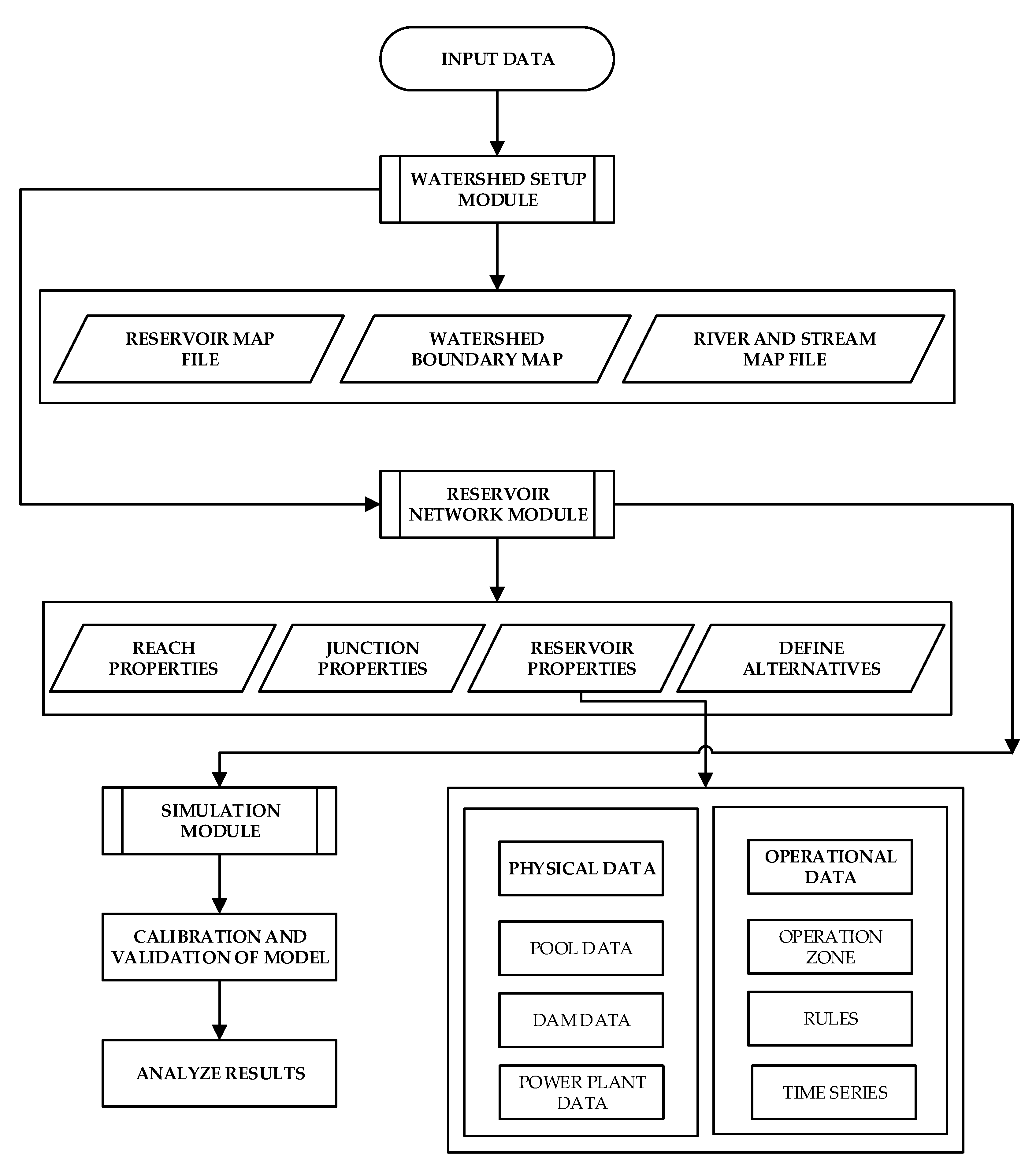
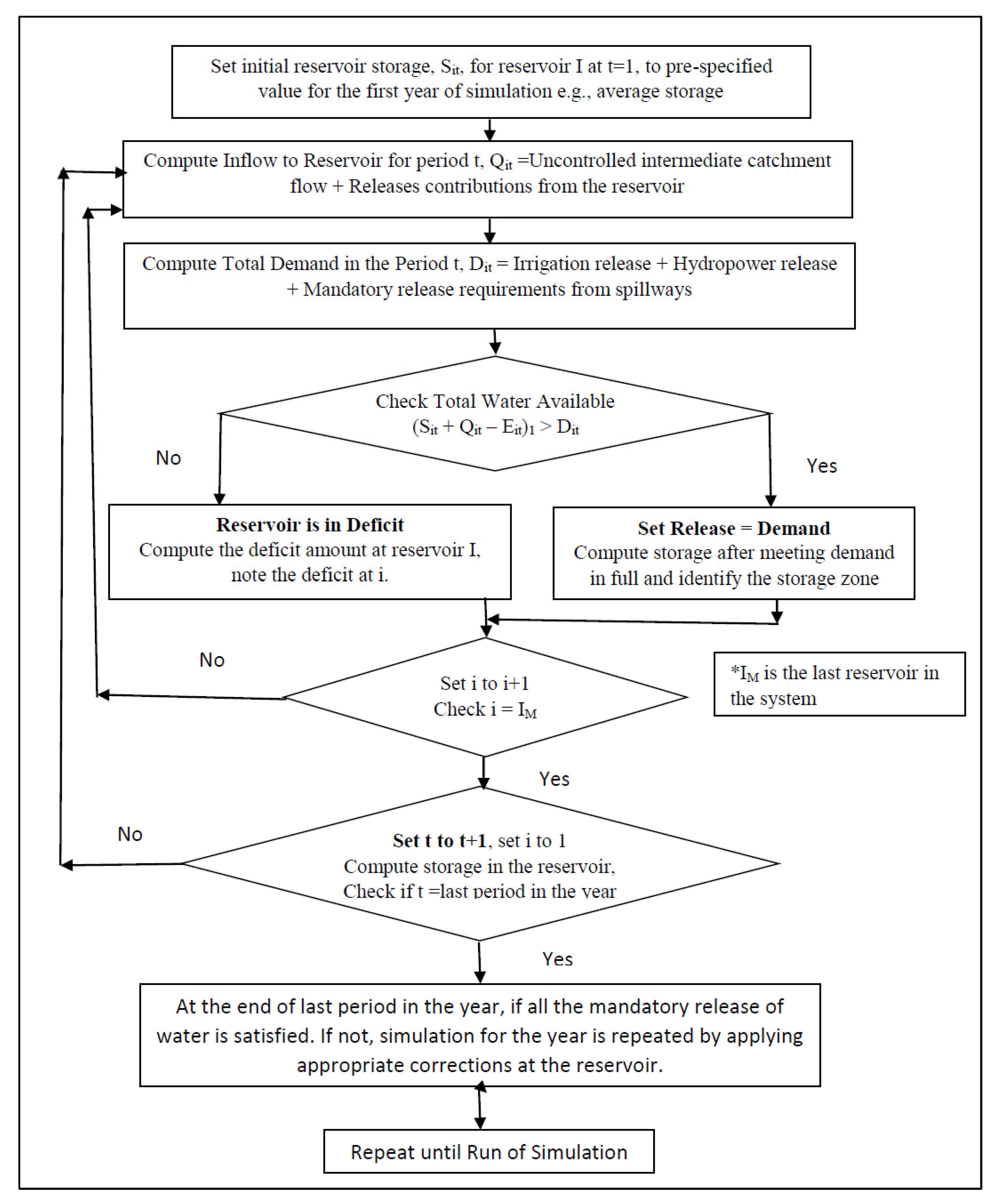
where St is initial storage, It is inflow at start, Rt is the releases required, Et is the evaporation and Ot are the outflows from the reservoir. The flow chart of HEC-ResSim simulation model in given in Figure 3.

2.3. Sedimentation Studies of Tarbela Reservoir

The results of the HEC-RAS model [40,47] for different operating scenarios were investigated by adding around 1.2 m annually to the lowest operating level in scenarios 2, 3, and 4 for modelling sediments in the Minimum Pool Level at 420 m. (Scenario-1).
  • Minimum Pool Level: 426.7 m (Scenario-2)
  • Minimum Pool Level: 441.9 m (Scenario-3)
  • Minimum Pool Level: 457.2 m (Scenario-4)
  • Adding 1.2 m annually in minimum operating level of 420 m of year 2010 (Scenario-5)
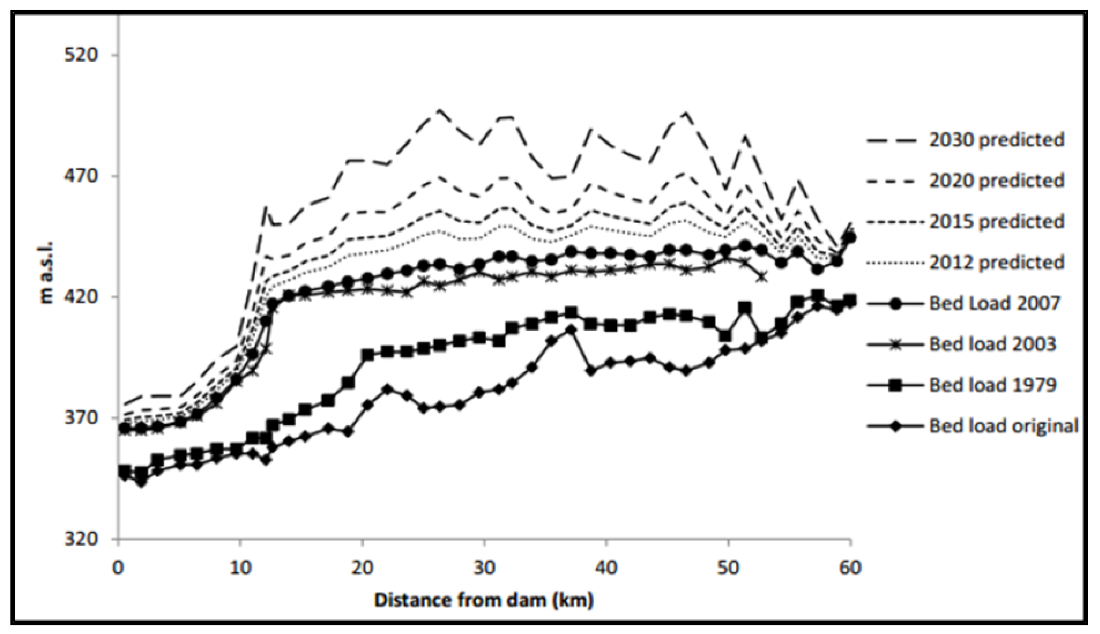
Sediment deposition will occur in Tarbela Lake’s higher reaches if the reservoir is managed according to scenario-5, slowing the average rate of sediment delta progression [47,48]. The reservoir’s maximum life would be up to 2035, according to WAPDA’s present operating mechanism, as its storage capacity would be reduced. If the reservoir is operated at the present WAPDA levels, the pivot point of the delta will be very close to the dam face, and Tarbela will become a run-off-the-river type project with just 2.87 BCM of gross storage by 2035. The pivot point of the sediment delta in 2035 will be 2.41 kilometres from the dam face. The location of the Tarbela Reservoir sediment delta profile is depicted in Figure 4 [40,47].
When the reservoir’s gross capacity is decreased to 20% of its designed capacity, its practical life is deemed to be over. The reservoir at Tarbela was estimated to be usable for 85 years. Due to sedimentation, the reservoir’s live storage capacity would continue to drop, resulting in a progressive reduction in water delivery. Tarbela will become a run-of-the-river project after 2035, with a gross storage capacity of 2.87 billion cubic metres [40,47]. Table 2 indicates that the storage capacity of the Tarbela reservoir under various operational scenarios.
As shown in Figure 5 [49], sediment input has altered the Tarbela Reservoir bed level, resulting in a 100 percent storage capacity loss in the reservoir up to 2030, and hydropower-producing capability will also be threatened.
In other research, a sedimentation study of the Tarbela Reservoir was carried out [50]. The useful life of the reservoir was assumed to be 85 years, however, its live capacity would be constantly in decline and would reduce energy generation and irrigation releases [50]. The Indus River will absolutely fill Tarbela Reservoir with sediment under the current operational strategy. Tarbela is presently losing 123 MCM/year of storage capacity to sedimentation, putting at danger the ability to fulfil downstream irrigation releases and 6338 MW of power generating capacity, including current and under-construction units at Tarbela and Ghazi Barotha headwork, which is absolutely dependent on sediment management strategy at Tarbela [7].
After the 2016 hydrographic survey of the Tarbela reservoir, the revised live and gross storage capacities were estimated as 6.174 and 7.084 MAF, respectively, indicating that the losses in its live and gross storage capacities were 3.505 and 4.536 MAF, which were 36.212 and 39.036%, respectively. Average loss rate in the gross storage capacity of Tarbela Reservoir is 0.108 MAF/year. If the current reservoir sedimentation rate continues in the future, then 80% of the reservoir volume will be filled with sediment in next 52 years. If the average delta advancement rate is considered for future years, then the Pivot Point of the delta will approach the dam face in 22 years. The useful life of the Tarbela Reservoir would be exhausted by 2038 [14] as given in Table 3.

3. Tarbela Reservoir Standard Operating Procedures (SOPs)

The current WAPDA standard operation procedure for Tarbela Reservoir is given below [51];
  • Tunnel Nos. 4 and 5 are generally operated up to the reservoir elevation 458.72 m. The gates of these tunnels are opened at full gate capacity during the operation. These irrigation tunnels operated above 458.72 m only in grave emergency conditions.
  • The reservoir should not be filled at a rate of more than 3 m in a 10-day period while the reservoir levels are more than 460 m to ensure the structural protection of the dam embankments against severe earthquakes.
  • Spillways will be operated between the reservoir elevations 458.72 m and 472.44 m. The operating guidelines for both service and auxiliary spillways are given below:
  • When the reservoir approaches the elevation of 458.72 m, the Auxiliary spillway is put into operation. Its initial operation would be free flow because the flipping process is not possible when the average discharge of the Auxiliary spillway is less than 1415.84 m3/s and the Service spillway is less than 2548.52 m3/s.
  • When the discharging capacity of the Auxiliary spillway approaches or exceeds 5833 m3/s, then the Service spillway is put into operation with a discharge capacity of more than 2548.52 m3/s.
  • When the discharge capacity of the Auxiliary spillway is above 7080 m3/s, then gates no. 2 and 8 are lowered by one third of their capacity.
  • The raising of the Service and Auxiliary spillway gates start from the end gates of both spillways, i.e., in the case of the Auxiliary spillway gate no: 1 and 9, 2and 8, 3 and 7, 4 and 6 and 5 are raised. The gate raising pattern of the Service spillway is just like that of the Auxiliary spillway.
  • The lowering pattern of the spillway gates starts from the centre, i.e., the lowering of Auxiliary spillway gates starts from middle gate no. 5, 4 and 6, 3 and 7, 2 and 8, and 1 and 9.
  • When both the spillways reach free flow condition, all the gates of both spillways are raised equally to protect the d/s gates from turbulence.
  • The service and auxiliary spillway gates are not allowed to operate with a fraction of a foot opening.
  • The operation pattern of all the gates of both spillways is same, but gates no. 2 and 8 of the Auxiliary spillways are suppressed by 1/3 of the opening of the remaining gates to protect the chute walls from splashes.
Rule curves were developed for only the Tarbela Reservoir without considering the conjunctive operation of multiple reservoirs and to fulfil the irrigation demands and power demands as a by-product. The original MOL 396.3 m of Tarbela Reservoir was modified to 401 m, 408 m up to 1995, 412 m after 1995, 417.2 m in 2002, and to 420.3 m in 2010, respectively. The purpose of the increase in MOLs of Tarbela Reservoir by WAPDA was to protect the power tunnels from the advancing sediment delta [40]. The existing Tarbela Reservoir operations rule curves were reviewed and modified according to the 6th Periodic Inspection of Tarbela Reservoir [14] by keeping the minimum operating level 2.1 feet higher than the pivot point elevation of the reservoir sediment delta.

4. Material and Methods

The HEC-ResSim model may incorporate any single- or multifunctional reservoir system due to its flexibility accompanied by new powerful features making it adaptable tool for reservoir operations. As a decision-supporting tool, it aims to satisfy the needs of modelers working on reservoir projects [32].
Using HEC-ResSim, complex flood management procedures may be modelled, promoting the operation of multifunctional reservoir systems. The Corps Water Management System is a significant application for ResSim (CWMS). The primary objective of the CWMS is to assist USACE reservoir system operations in real-time via means of flood control. The ResSim intervals range from 15 to 30 minutes daily [52,53,54]. From DOS to Windows, it has enhanced the user interface. Other HEC systems, such as HEC-HMS, HEC-RAS, etc., have graphical user interface (GUI) capabilities that can be connected. The model was successfully used in many reservoir processes, such flood control, irrigation, hydropower simulation, water supply, and environmental quality control. Rosenberg [46] successfully used HEC-ResSim to model reservoirs in the Sacrament and San Joaquin Basins of the District of California; ref. [55] used HEC-ResSim successfully for flood control on the Columbia River in the United States. Additionally, its application was successful in the Forgotten River part of the Rio Grande/Bravo basin [56]. Further its application was successfully implemented for analysing climate change impacts on future power generation for the Mangla reservoir, Pakistan [39].
The HEC-ResSim model does not possess the capability for including sediments. To obtain release and power values for present and future scenarios considering a sediment effect, the HEC-RAS sediment model was linked with the HEC-ResSim model to acquire updated elevation-capacity relationships. Therefore, considering the worldwide proven accuracy of the HEC-ResSim model, it was decided to develop the model for the present study to simulate the operation of the Tarbela Reservoir to assess the impact of the WAPDA’s present SOPs on the future operation and predicted future power and water releases due to a rapid reduction of its live storage. The prediction of the optimized future operation was assessed on a 5-year basis from 2025 to 2035 to determine storage capacity, irrigation releases, power production and energy generation. Further, the impacts of the operational strategy during the Kharif period (April to September) and Rabi period (October–March) irrigation releases were predicted for future application years along with the impact on reservoir capacity upon sedimentation. To achieve reliability of the model results, the simulated data was compared with observed data—Nash and Sutcliffe Efficiency [57], Index of Agreement (IOA) [58] and Run-off Ratio (RR) [38] tests—were used for calibration and validation of model results.
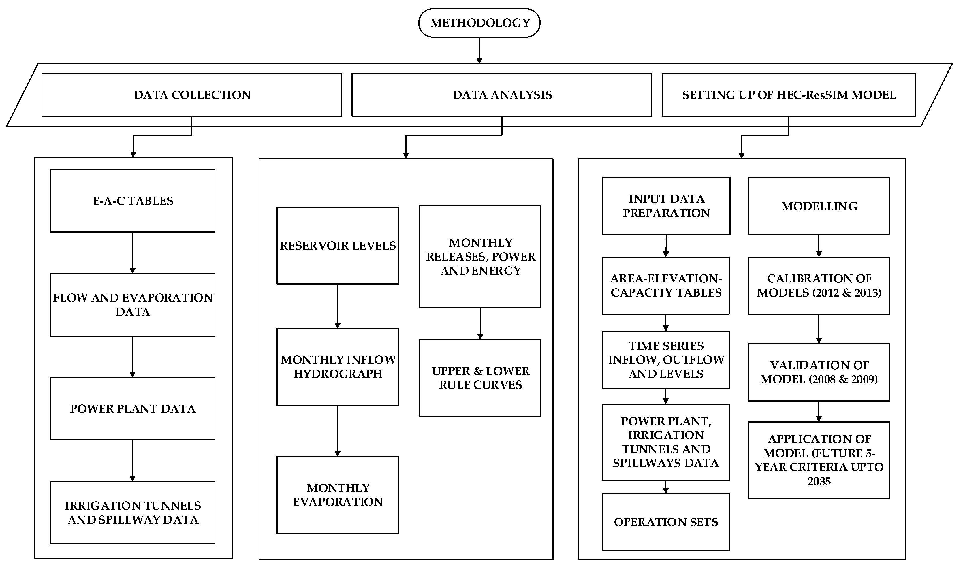
The overall methodology with different stages is described in the flow chart in Figure 6.

4.1. Data Collection

In order to model the reservoir operation of Tarbela, data were collected from the Surface Water Hydrology Project (SWHP), WAPDA, Hydrology and Survey, TDP and from previously carried out studies [40,47] as shown in Table 4. The data includes storage capacities of reservoir at different elevations, time series flow data, time series power generation pattern, area-elevation capacity tables, rule curves, and evaporation data of the reservoir for different years.

4.2. Data Analysis

Data from 2008, 2009, 2012, 2013 and 2020 were collected and analyses of inflow, outflow, reservoir levels, and power and energy generation were carried out to determine the reservoir operation pattern of past years. Data analyses were carried out for the following parameters.

4.3. Monthly Inflow Hydrograph

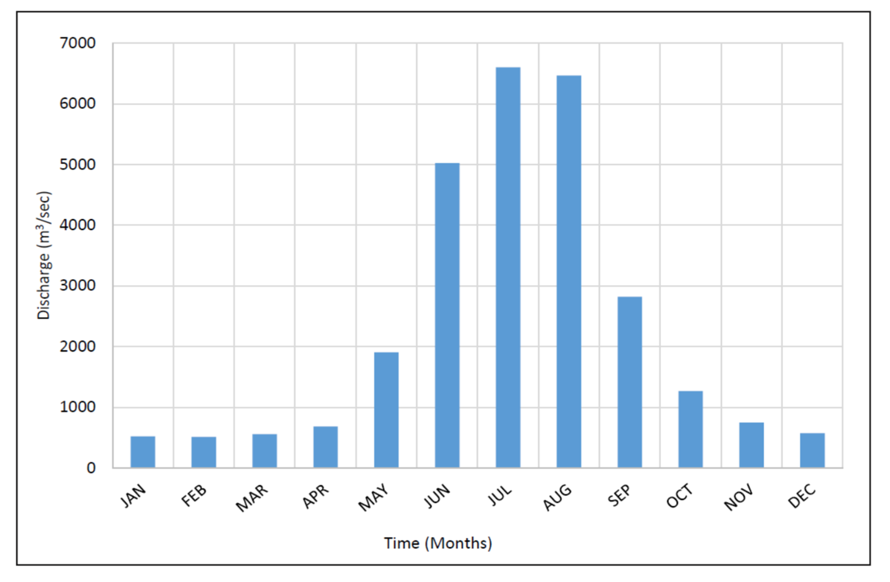
The mean monthly inflows at Besham Qila are shown in Figure 7. Maximum and minimum inflows were in the months of August and February with an average annual flow of is 64 MAF (79 BCM).

4.4. Tarbela Reservoir Levels

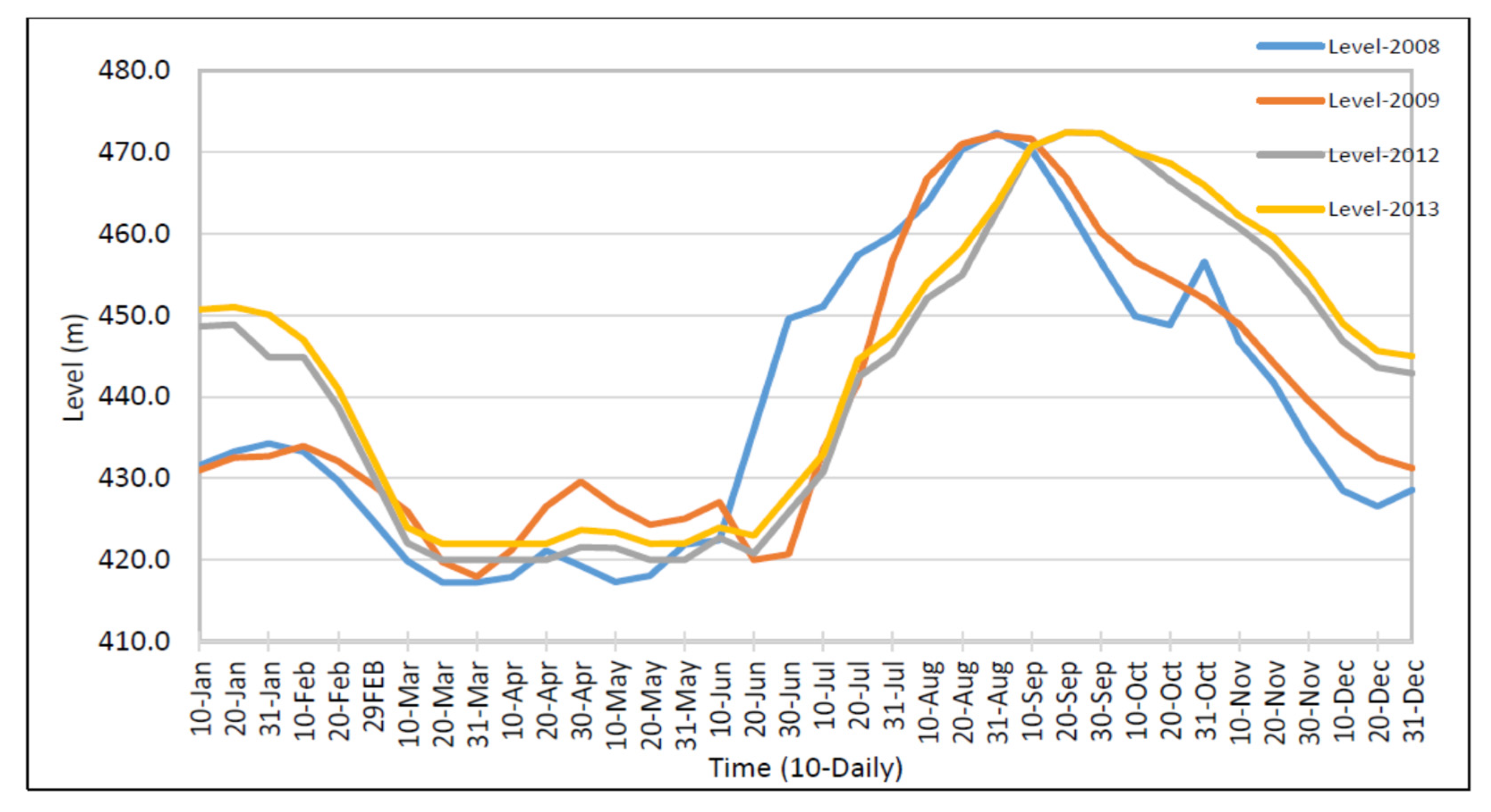
Operating levels at the dam followed a drawdown and fill cycle. Tarbela Reservoir levels were low during the months of March, April, and May, and were high during the months of August, September, and October. During the months of March, April, and May, there was great irrigation demand on downstream of dam and after the sowing season the reservoir was again filled and the reservoir attained the previous maximum reservoir level during the summer season as shown in Figure 8.

4.5. Releases from Tarbela Reservoir

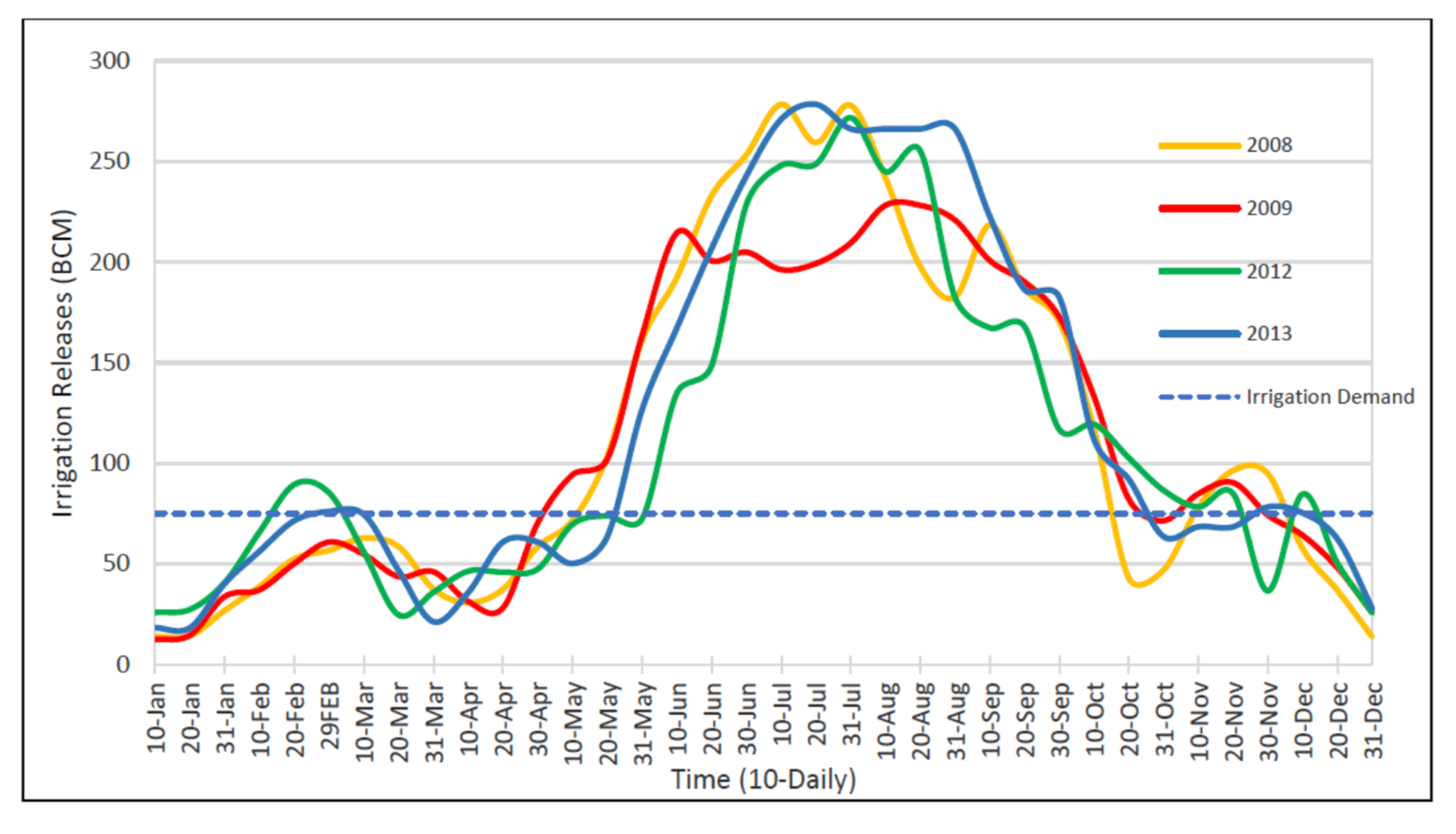
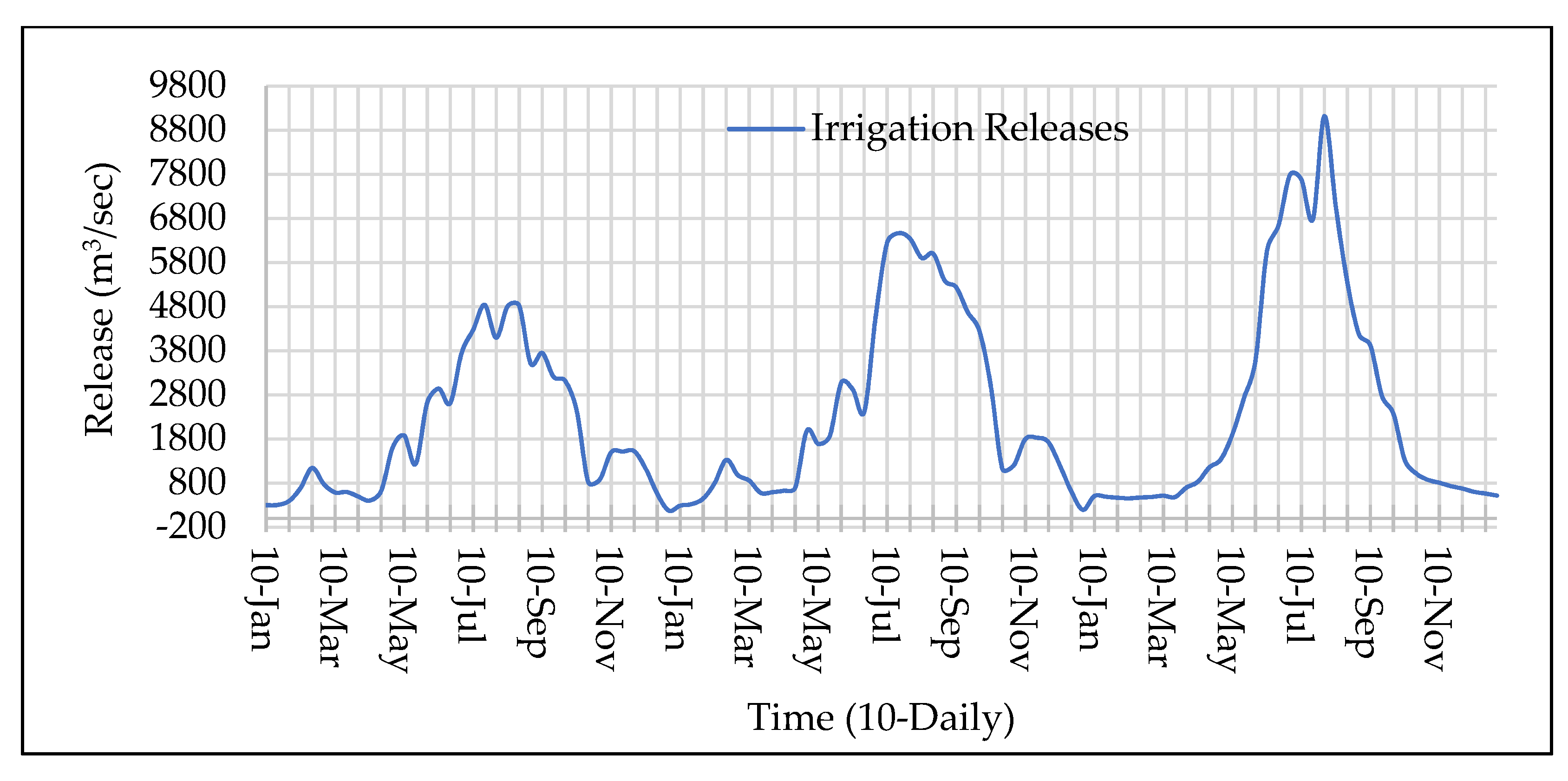
Releases through the reservoir were dependent on the downstream release requirement and available storage at the particular instant. Releases during 2008, 2009, 2012 and 2013 are shown in Figure 9. Rule curves of Tarbela were developed based on the downstream Tarbela command area known as “Kirmani Demands in Pakistan”. Tarbela contribute 75.1 BCM to total annual irrigation supplies for IBIS (10.8BCM for Rabi and 64.3 BCM Kharif).

4.6. Power and Energy Pattern

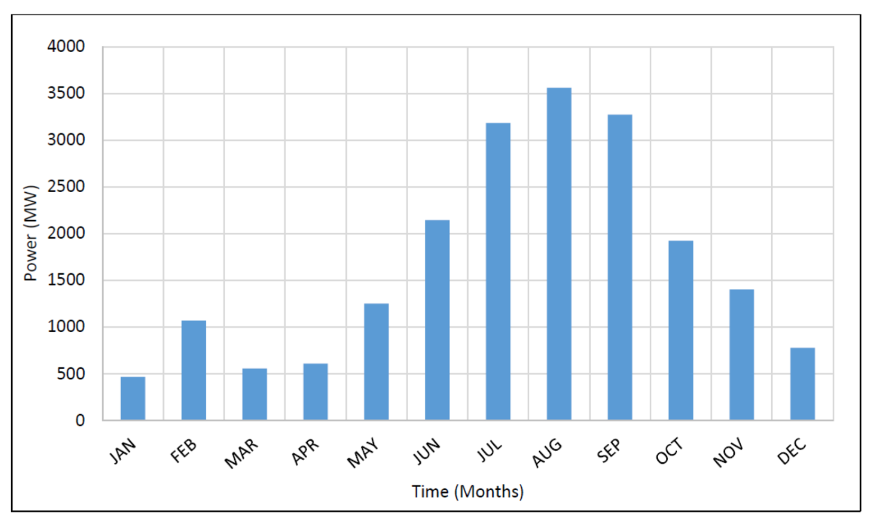
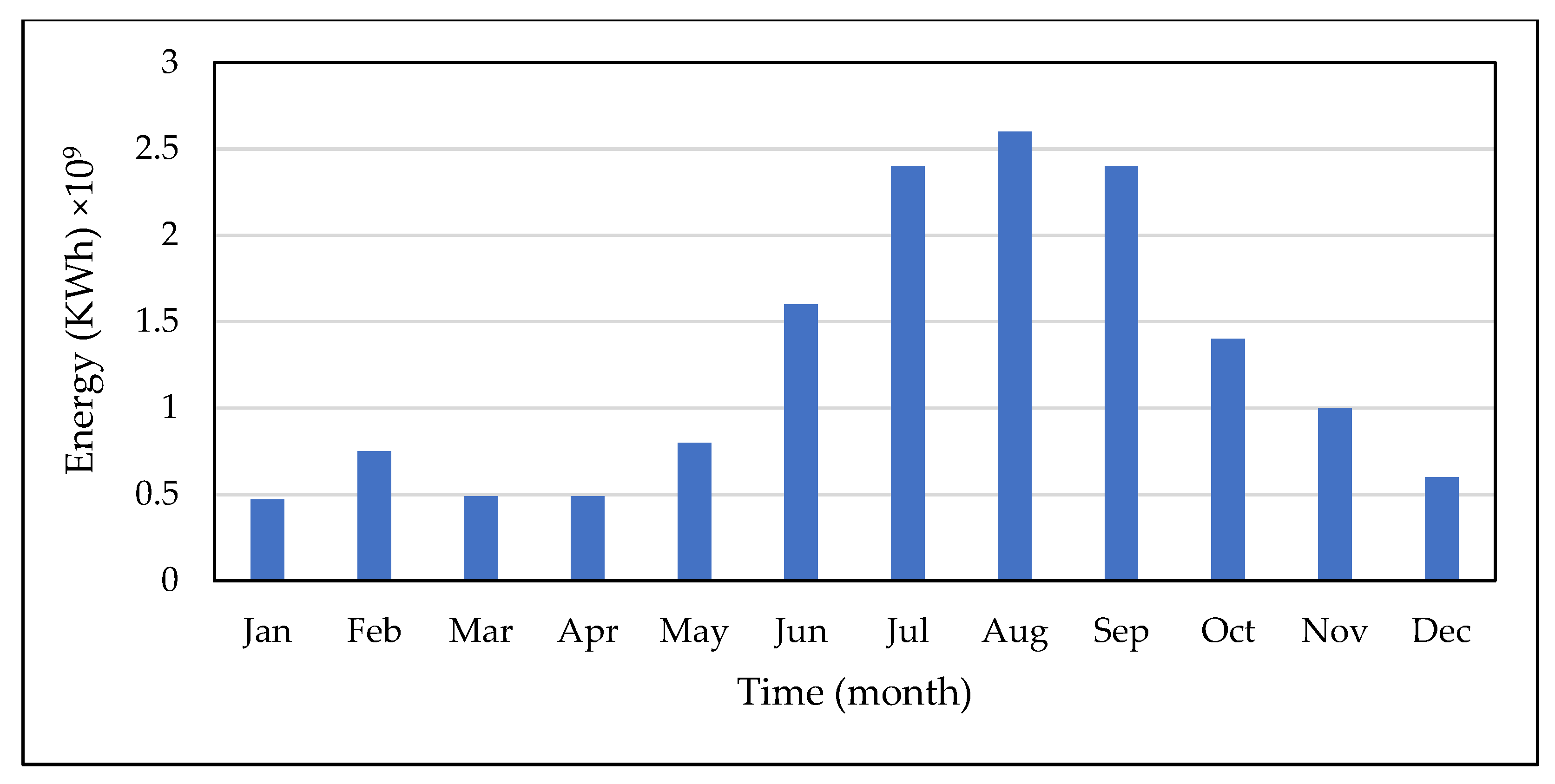
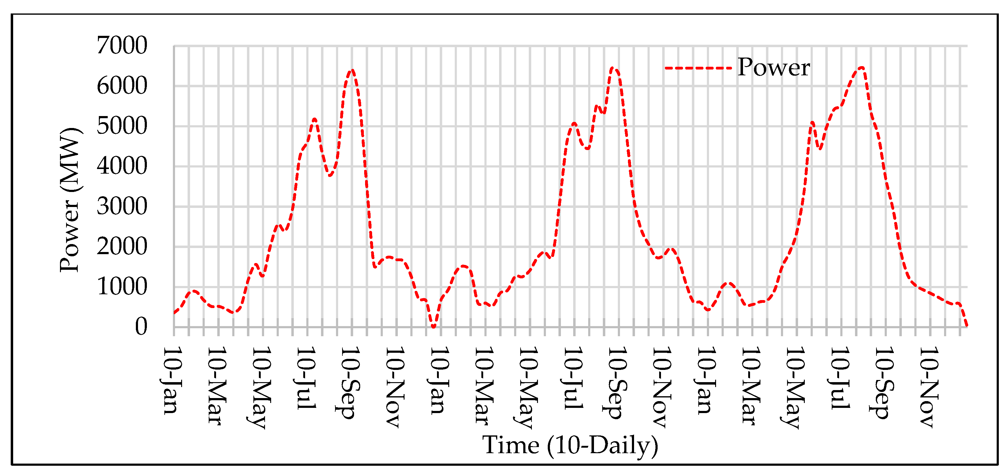
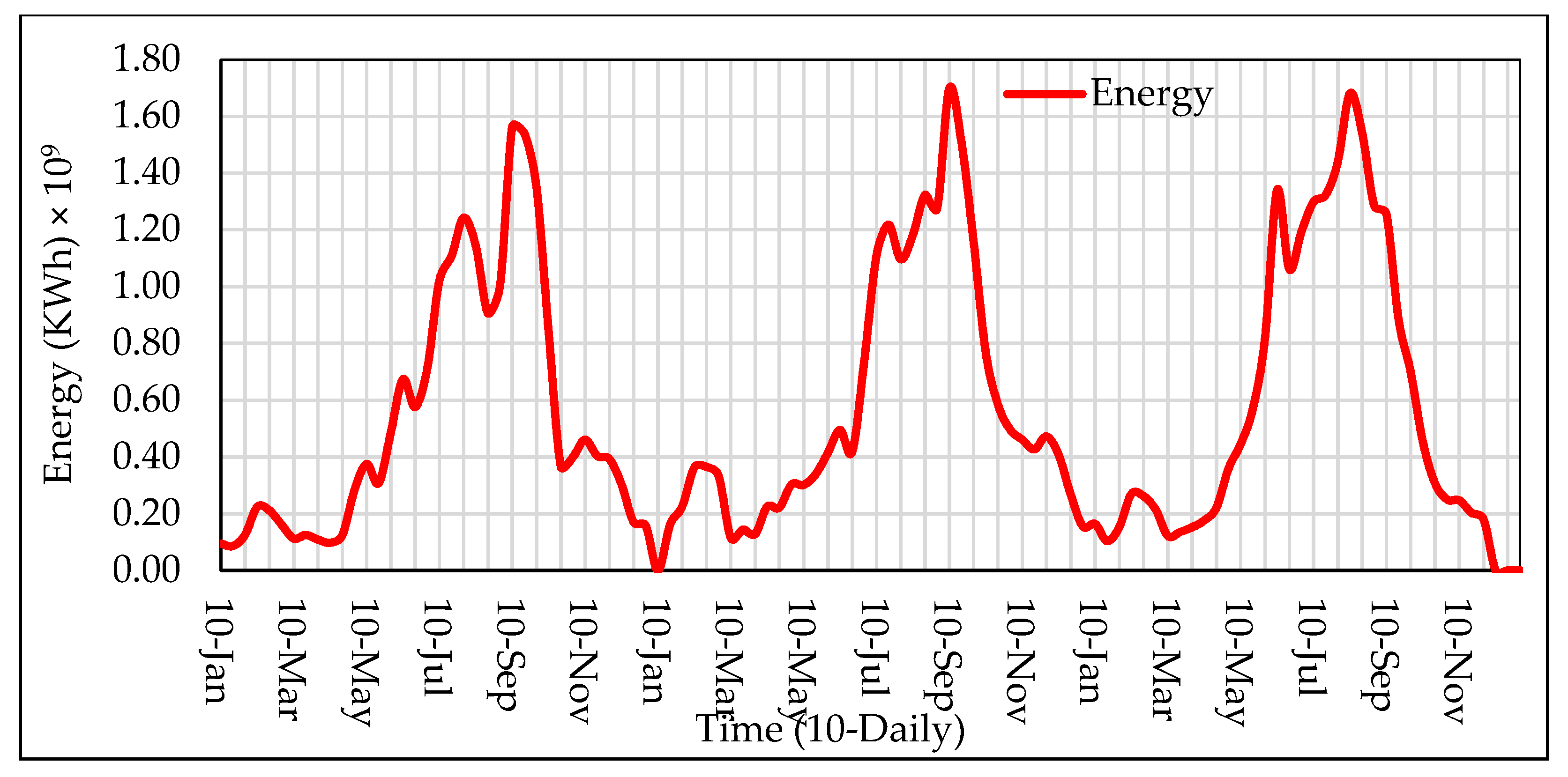
Tarbela is a hydropower dam, where the d/s irrigation demands limit power production. Tarbela Reservoir is an important part of the IBIS system and the releases operations of the reservoir are integrated with IBIS. The irrigation demand during the Kharif season is more on downstream of the reservoir, so, as the releases from the dam increase, the releases are preferred to pass through the power tunnels. Therefore, by fulfilling the irrigation demand, power and energy is generated as by product. The pattern of power generation and energy generation in Figure 10 and Figure 11 indicates that the power and energy generation is maximum during the summer months and low during the winter months.

4.7. Reservoir Storage Capacities

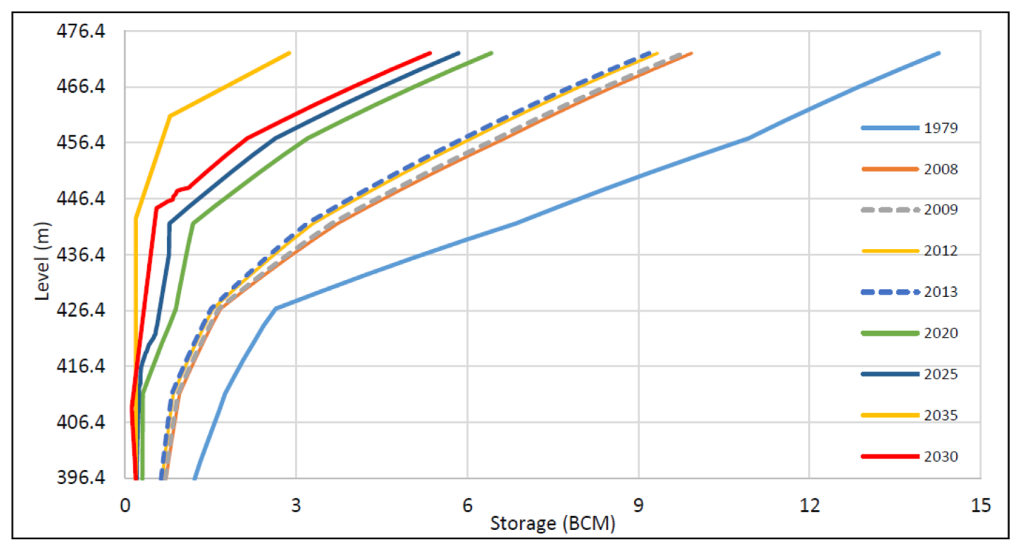
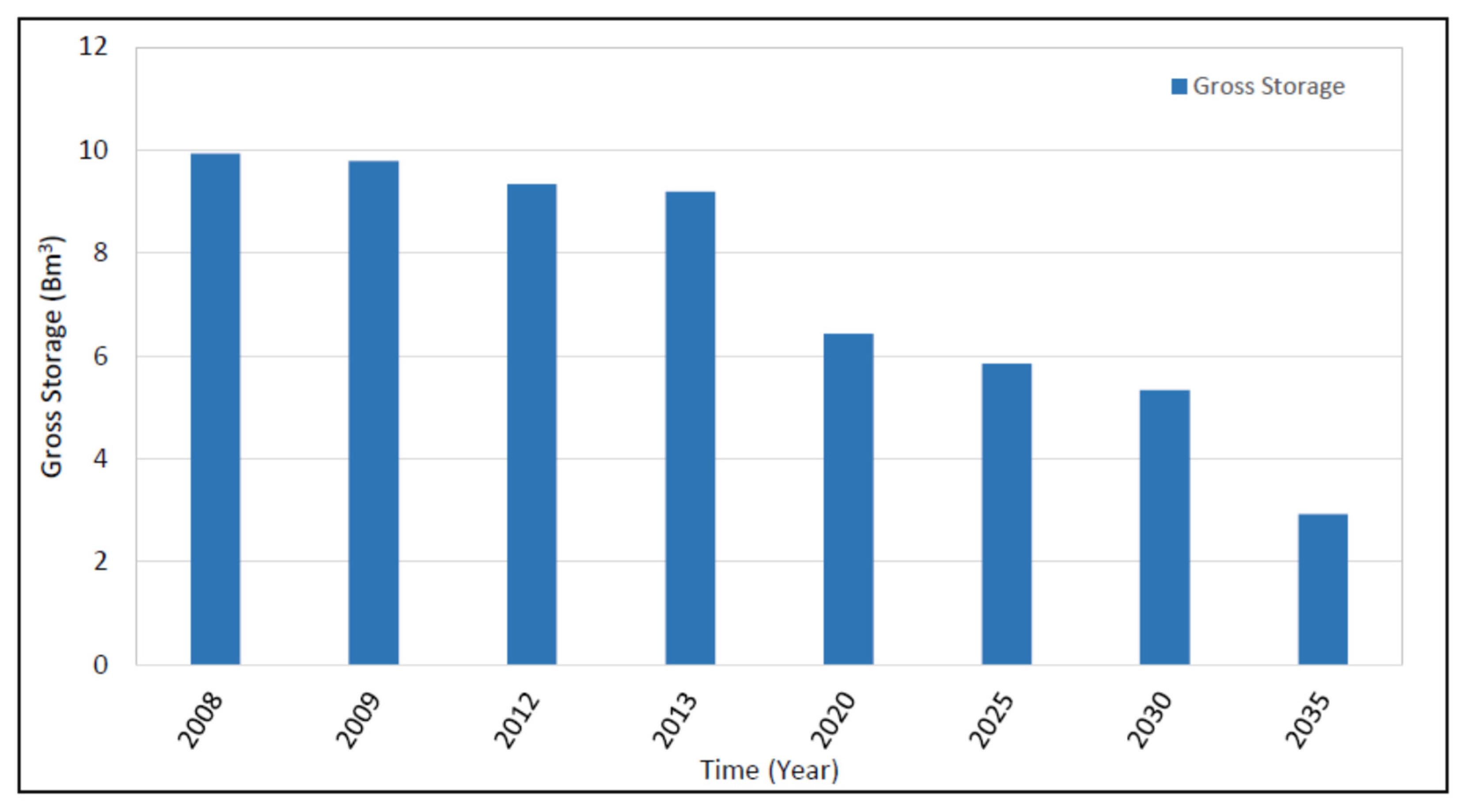
The storage volume of the reservoir is exhausted very quickly due to the erosive nature of the upper catchment. As a result, the rate the reservoir sediment delta pivot point rises and advances is very high. Based on the current progress of the reservoir sediment delta pivot point, it is expected that the gross storage capacity of the reservoir would be fully exhausted very soon, as the average sediment deposition rate is 0.134 BCM/annum. To check the effect of reduction in storage capacity on irrigation releases and power generation pattern, the reservoir storage capacities for different years were used in this study (2008, 2009, 2012, 2013 and 2020) and future applications years (2025, 2030 and 2035). The gross storage capacities of Tarbela Reservoir at different elevations for different years are shown in Figure 12 [40,47].

4.8. Reservoir Rule Curves

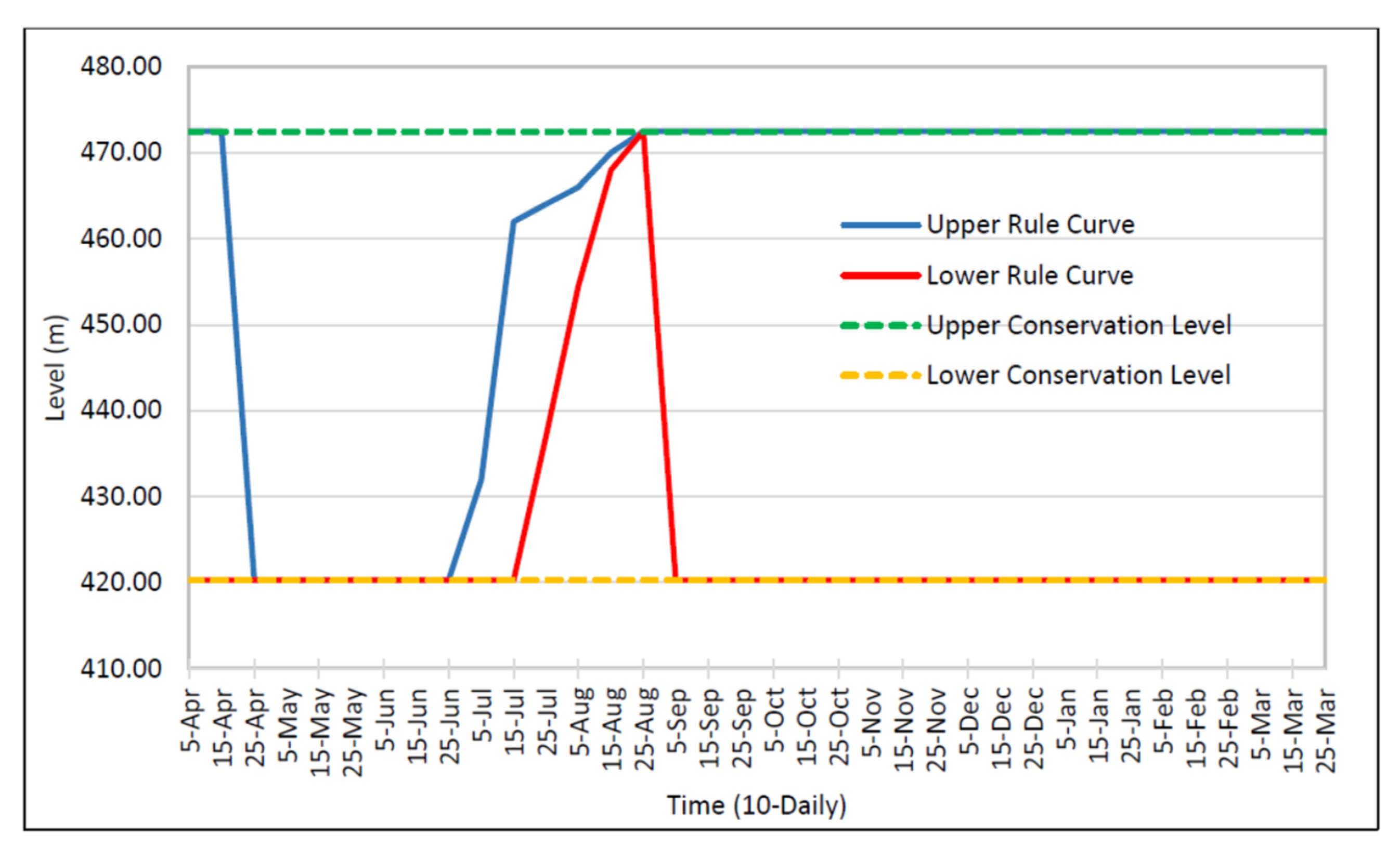
Tarbela Reservoir is being operated using predefined guide curves called rule curves, i.e., maximum and minimum, developed to meet irrigation demands. The original design rule curves were developed based on inflows, losses, present capacity of reservoir, maximum and minimum conservation levels, earthquake, structural and geotechnical safety and with consideration of irrigation requirement as the priority, and hydropower as a by-product. The reservoir should not be allowed to drawdown to its minimum conservation level in the months of late May to early June due to high irrigation demand then. The WAPDA rule curves for Tarbela Reservoir operations are shown in Figure 13 [59].

4.9. Evaporation Data

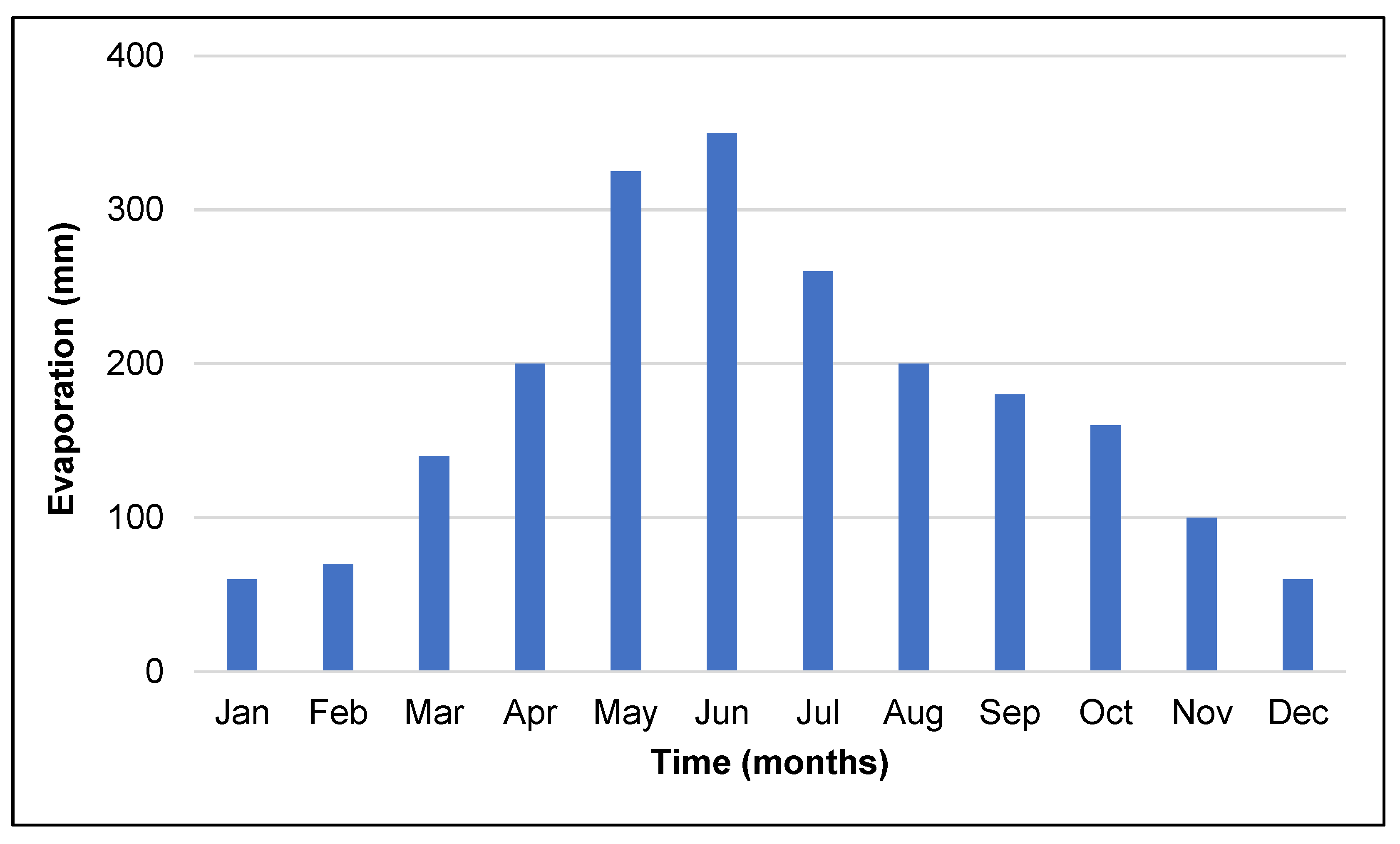
The analysis of pan evaporation presents that evaporation is maximum in June and minimum in December. Evaporation is maximum during the summer season and minimum during the winter season as shown in Figure 14.

5. Tarbela Reservoir Simulation Using Hec-ResSim

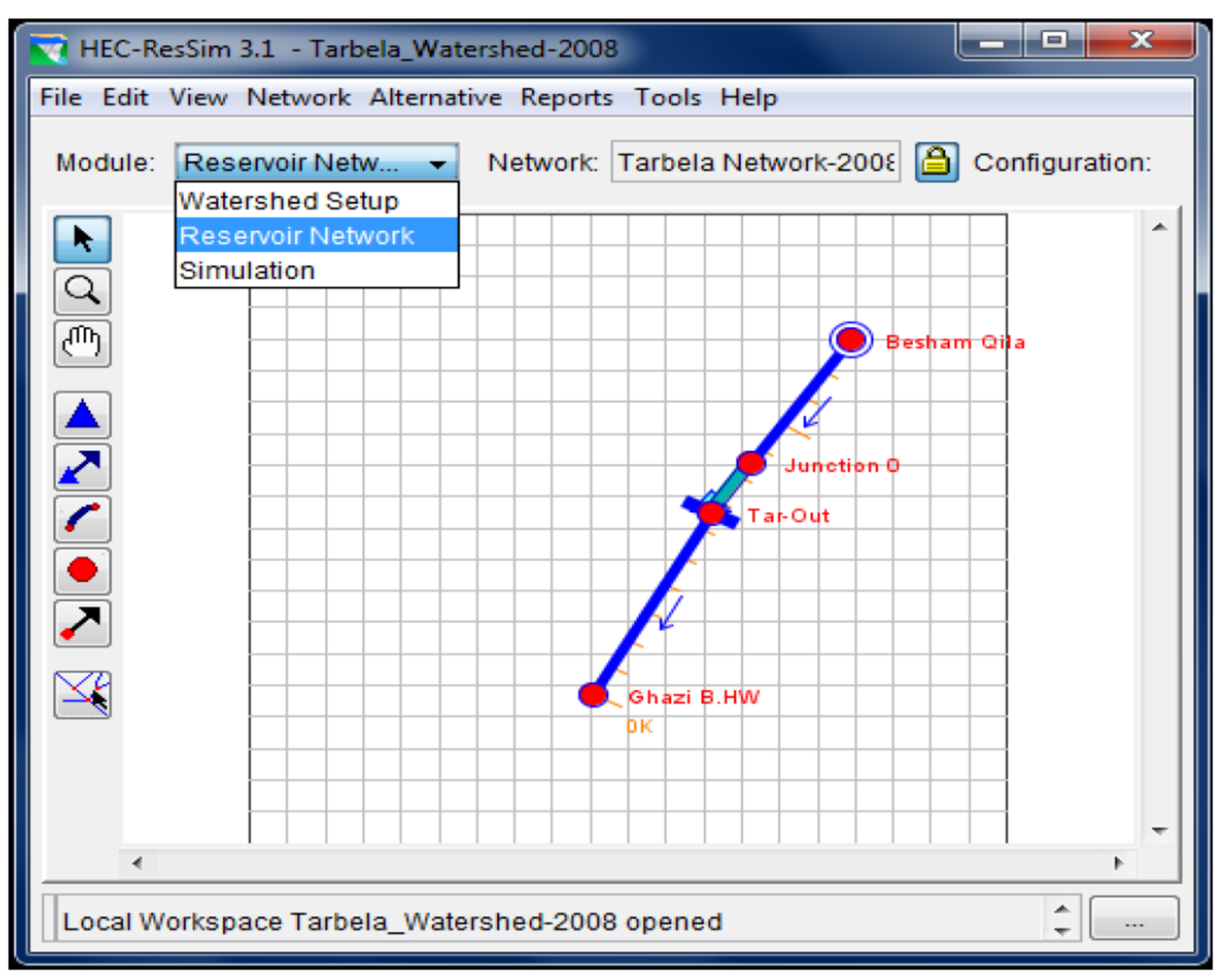
The input screen of Reservoir system modelling using the HEC-ResSim model of the Tarbela Reservoir as shown in Figure 15.
The main objective of the Watershed Setup module was to give a setup to create the watershed. The watershed setup module is the part of other HEC generations like HEC-RAS, HEC-ResSim, HEC-FIA and HEC-HMS. The Tarbela Reservoir watershed is related to the alignment of upstream and downstream reaches of the Indus River and the Tarbela Reservoir in the watershed. The watershed setup module includes all the streams, projects (reservoirs), time-series locations, impact areas, computation points and hydraulic and hydrologic data points for the watershed area. The final configuration of all these elements is used to generate the watershed framework.
The Reservoir Network is the second step and is the most complicated module of the software. In the Reservoir Network module, the river and reservoir schematic diagram shows the operational elements and the physical parts of model, and the new alternatives can be developed so that they can analysed in the simulation. Then the river reaches and the remaining network elements were connected to accomplish the network scheme. The operational and physical data for each element of the network were incorporated on finishing of the schematic figure. Alternatives were developed that describe the operation sets, initial conditions, reservoir network and DSS time series files [60].
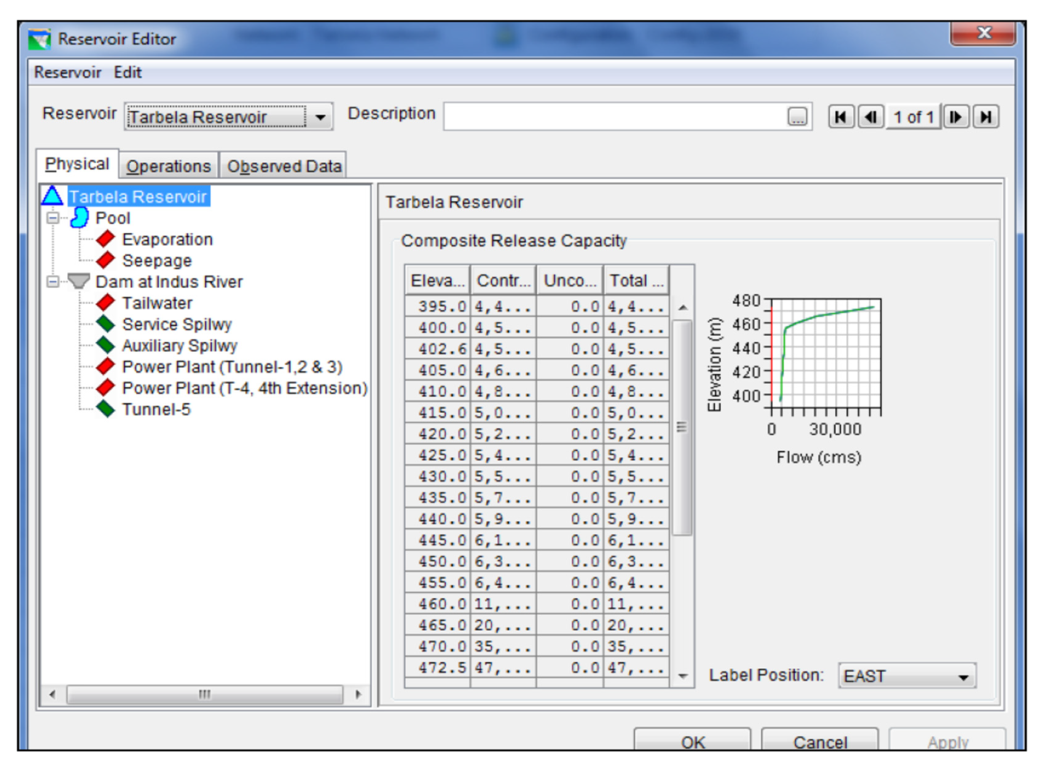
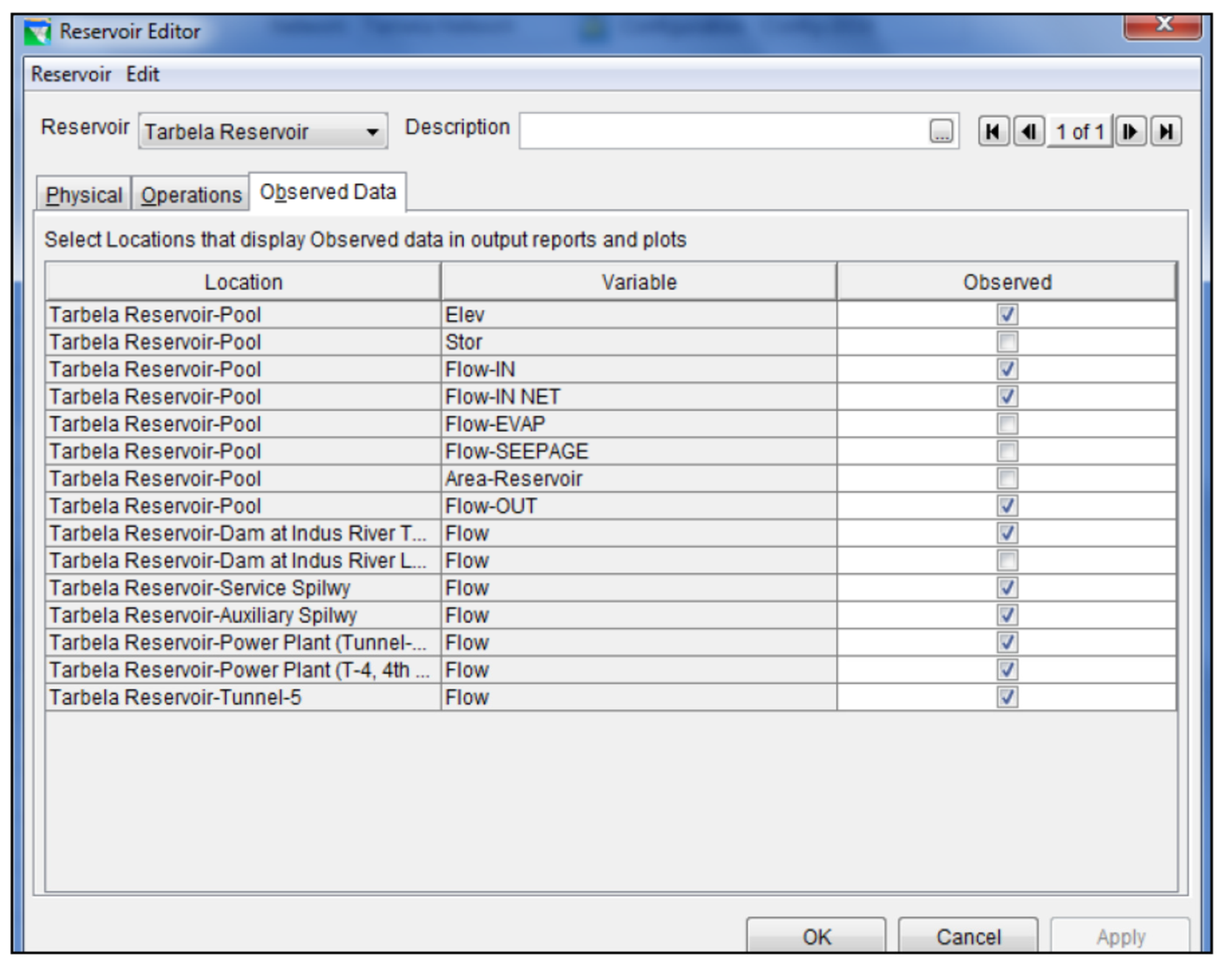
The network parts that are demonstrated by HEC-ResSim may have four types, for example, junctions, routing reaches, reservoirs, and diversions. Different modules of the HEC-ResSim model are shown in Figure 16. The Physical data tab and the Observed data tab of the Reservoir Editor of the Model are shown in Figure 17 and Figure 18, respectively.

6. Simulation Procedure and Results

The simulation module was used to separate the output results from the development of the model. After the definition of the alternatives and completion of model, the module was used to run the simulation. It was required to define the simulation time window, alternatives to be assessed and simulation run interval. The DSS file consisted of all the DSS records that shows the input and output time series data for the considered alternatives. Besides this, elements may be saved and edited for further simulations.
The main concepts of the theoretical development of the reservoir network consists of two parts: A physical part that includes the Tarbela dam and reservoir, spillways, dam structure, tail waters information and correct information of all these is very important for an adequate result. The second part of the reservoir network is the provision of operation rules for the Tarbela Reservoir—that is a basic step in the model development. The description of this portion is really complicated and require a lot of information and hydrological and hydraulics equations are used for calculation. Conditional portrays like if, or, then, and rules are used for the better development of the Tarbela Reservoir simulation model.
The physical part is a very important part in the HEC-ResSim model as even minor changes affect the behaviour of the reservoir system. The physical part input consists of dam parts and reservoir details that consist of the Tarbela power plant detail, spillways, reservoirs storage and pool surface area, dam crest, length of crest of dam was included. The mathematical water flow models for large areas include water inflow in reservoir, flow in open streams, and release from the outlet tunnels (spillways, power, and irrigation tunnels) of dam and power production in hydropower plants. Various types of flows that are considered in this study are:
  • Flow in the Indus River reaches that are interlinked with the Tarbela reservoir.
  • Changes in Tarbela pool storage.
  • Releases from both spillways of Tarbela dam.
  • Releases from irrigation tunnel no. 4 and 5.
  • Releases and power generation from power tunnel no. 1, 2 and 3.
Spillways are the controlled/uncontrolled outlets of a dam to pass the flood safely to d/s stretches of river safely. During the high flow season, the reservoir level increases and results in overflowing of the dam crest. In such condition, the turbine or spillway will cater to pass this surplus discharge to restrain towards the guide curve. In the case of the Tarbela dam, Auxiliary and Service spillways are used to spill the extra water from the reservoir in the flood season, and both spillways are put into operation when the reservoir level reaches 458.72 m. It is safe for the dam structure to operate both spillways up to a level of 472.44 m.
The releases from spillways were estimated by Equation (2). These calculations were crucial in determination of the operational rules and physical considerations. The maximum increase in reservoir level depends on the discharge capacity of both spillways at different reservoir elevations. The operation rules in operation sets for the discharge capacity of both spillways were used to spill excess water at different elevations. Spill from the Auxiliary and Service spillways were calculated with Equation (2):
Q = C·B·a·√2·g·Do,
where ‘Q’ is discharge (m3/s), ‘C’ is discharge coefficient (0.75 for streamlined and 0.6 at the sharp edge), ‘B’ is spillway width, ‘a’ is spillway gate above the threshold, ‘g’ is acceleration and ‘Do’ is water depth over spillway. Equation (3) was used to determine the releases from power tunnels no. 1, 2 and 3 for power generation:
Q = 0.102 × (En/(η × ℎ × t)),
where ‘En’ is the energy generation (MWh), ‘η’ is the efficiency, ‘h’ is Gross head (m), ‘t’ is time (h) and ‘Q’ is reservoir release (m3/s).
Pan evaporation of Tarbela lake was used to determine the change in pool storage due to evaporation. End pool storage after seepage, evapotranspiration and releases from spillways, power and irrigation tunnels was determined by the HEC-ResSim model from continuity Equation (4):
S2 = S1EVAP + (INFLOWOUTFLOWCQS
where ‘S1′ is end of period storage, ‘Evap’ is evaporation during time interval, ‘Outflow’ is power release and leakage, ‘CQS’ is discharge to storage conversation.
Tarbela Reservoir standard operation procedures were used in this study defined by WAPDA rule curves and IRSA according to crop water requirement and power generation d/s of dam that specify the Tarbela pool storage or required releases based on the time of year and the current reservoir storage in the reservoir. Tarbela Reservoir has upper and lower rule curves either in dry or wet season throughout the year.

7. Standard Guide Curve Operation by WAPDA

A reservoir’s targeted elevation at a certain instant is termed as Guide Curve. It is divided into an upper zone (i.e., maximum conservation or flood-control) and a lower zone (i.e., minimum conservation and dead storage). The main objective of Guide curve operation is to ensure releases from the dam and to preserve the reservoir storage level.
As per the standard guide curve operation by WAPDA, the standard release operation of Tarbela Reservoir is:
(i)
release water as quickly as possible when high inflows are trying to intrude into the flood pool
(ii)
limit releases to the minimum required essential to satisfy buffer, conservation, or hydropower demands when inflows are less, and storage level is below the guide curve.
(iii)
with the increase or decrease on inflows, standard guide curve operation will attempt to control the storage level back to the “Guide Curve”.
The standard Tarbela guide curve operations provided by WAPDA are given below in Table 5.
The release decision of HEC-ResSim states that a release is based on the range of release capacity through the physical limitations and defined rules. The maximum release is the total capacity of the controlled and uncontrolled outlets under certain elevation as per rating and the minimum release is also as per minimum capacity of the outlet, usually taken as zero [46].

8. Model Calibration and Validation

The HEC-ResSim Model was calibrated and validated for the releases and power generation from the Tarbela Reservoir throughout the wet and dry seasons according to WAPDA standard operation procedures for the year 2012, 2013 and 2008, 2009 respectively. The flow chart of the HEC-ResSim simulation run is shown in Figure 19.
The various simulations of the HEC-ResSim model indicates that the model was highly sensitive to the power plant efficiency. According to the WAPDA standard operations and by trial and error, the model generates the releases and power generation from Tarbela, and the patterns were approximately similar to the actual observed data throughout the year for the calibrated and validated years 2012, 2013 and 2008, 2009, respectively.

9. Reservoir Operation for Future Prediction

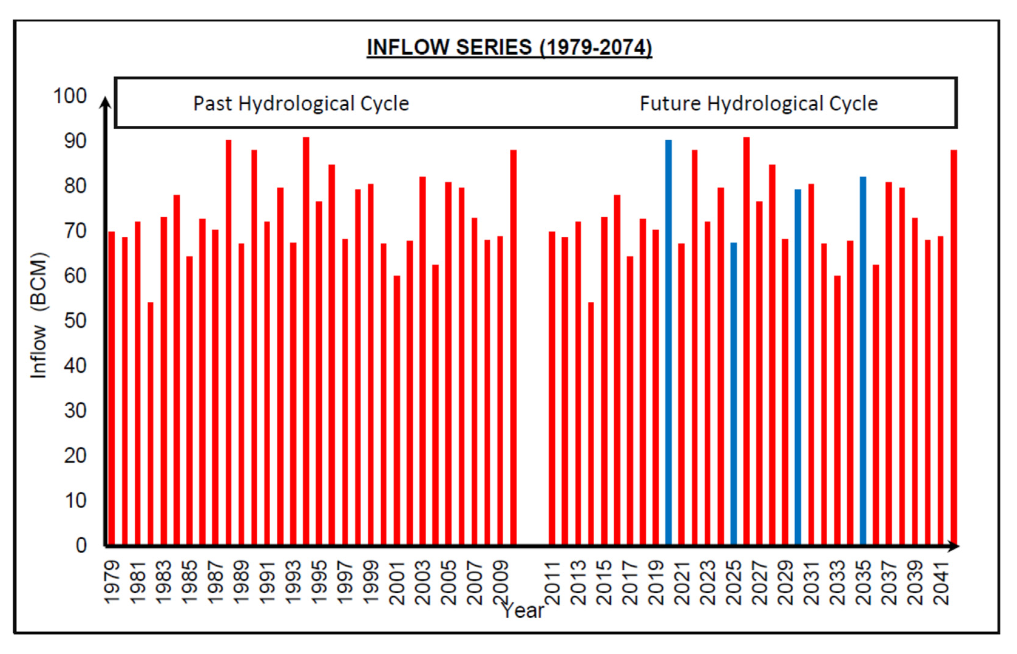
After calibration and validation of model, it was used to predict the future irrigation releases and power generation at different capacity values of the reservoir based on operating scenario-5 (according to WAPDA operations procedure). The inflow data for years 2025, 2030 and 2035 were taken from the two hydrological cycles of [40,47] as indicated in Figure 20.
The simulations for predicting the future conditions of the Tarbela Reservoir were carried out for the years 2025, 2030 and 2035 on a 5-year basis.

10. Coefficient to Check Accuracy of Model

10.1. Coefficient of Efficiency (COE)

Nash and Sutcliffe [57] indicated the coefficient of efficiency ‘E’ in the form of Equation (5). It is defined as the summation of the absolute squared differences between the simulated and the observed values and divided by the variance of the observed Õ values and subtract it all from 1 for the investigation period.
E = 1 i = 1 n ( O i   P i ) 2 i = 1 n ( O i O ¯ ) 2

10.2. Index of Agreement (IOA)

Willmott [58] used this index for comparing results from simulation with the observed data as stated by Krause et al. (2005). Its value varies between (0) and (1). This index can be determined using Equation (6):
ioa = 1 i = 1 n ( O i e i ) 2 i = 1 n ( | O i O ¯ | + | e i e ¯ | ) 2

10.3. Run-Off Ratio (RR)

The Runoff Ratio [38] is the comparison of the timing and magnitude of the observed and simulated data outflow hydrograph and elevation pool time series respectively.
RR = E [ O ^ ] E [ O ]
where O shows observed data and Ô shows the simulated data; RR is the dimensionless ratio and E[O], E[Ô] are the average daily observed and simulated hydrograph or pool elevation variation respectively.

11. Results and Discussion

To investigate the operation patterns of the Tarbela Reservoir, data for irrigation releases, power generation and energy generation from the power plant were collected. The results of the model were compared with these data. These results are presented in the form of a comparison between the observed and predicted dam releases, power, and energy for the existing WAPDA operating scenario for the future years.
According to 6th Periodic Inspection Report of Tarbela Reservoir [14], the minimum operating level of the Tarbela Reservoir is needed to keep the minimum operating level of the reservoir 2.1 ft. (0.640 m) higher than the pivot point elevation of Tarbela sediment delta. The current sediment delta pivot point elevation is 422.6 m, and the minimum operating level is 423.31 m.
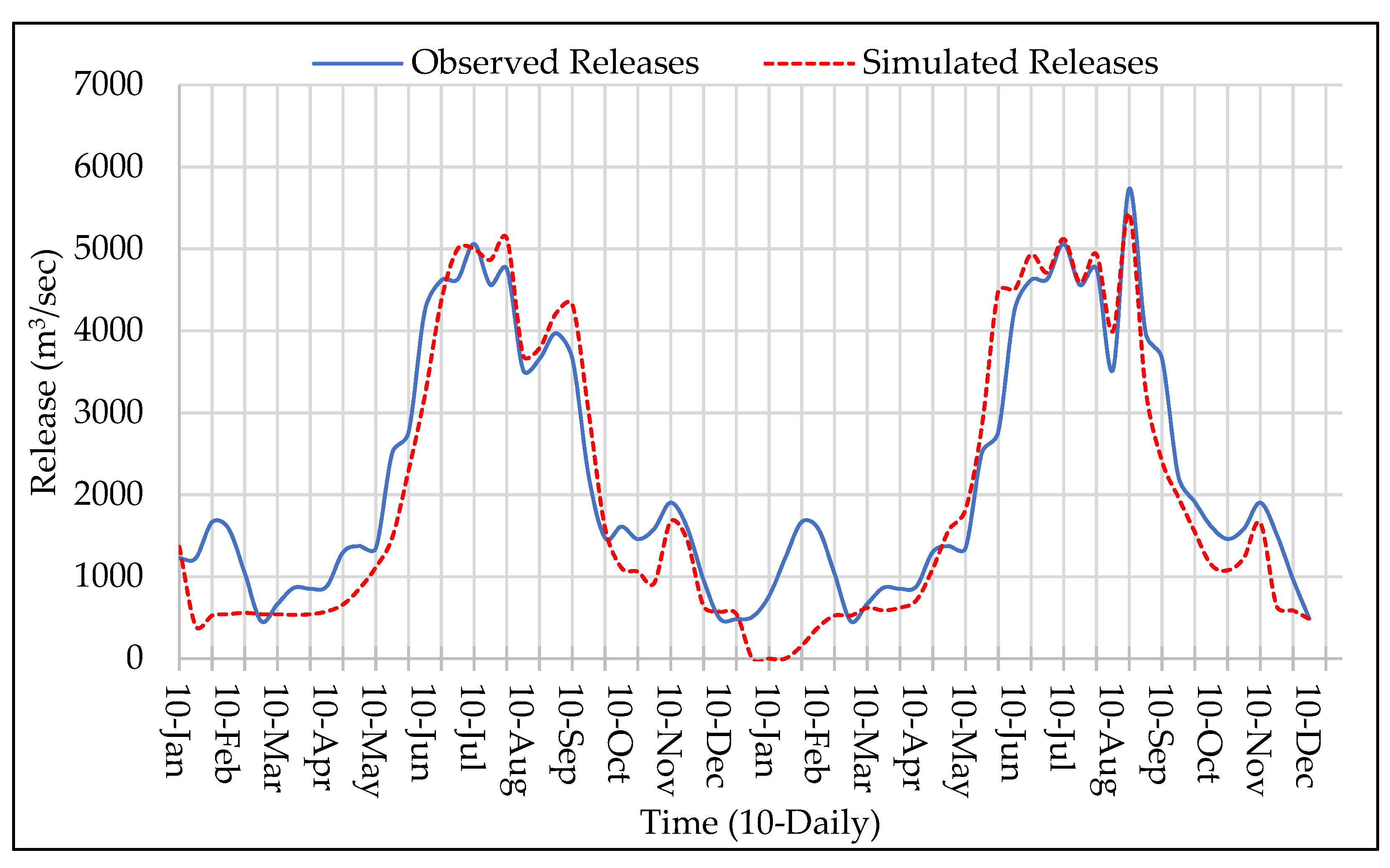
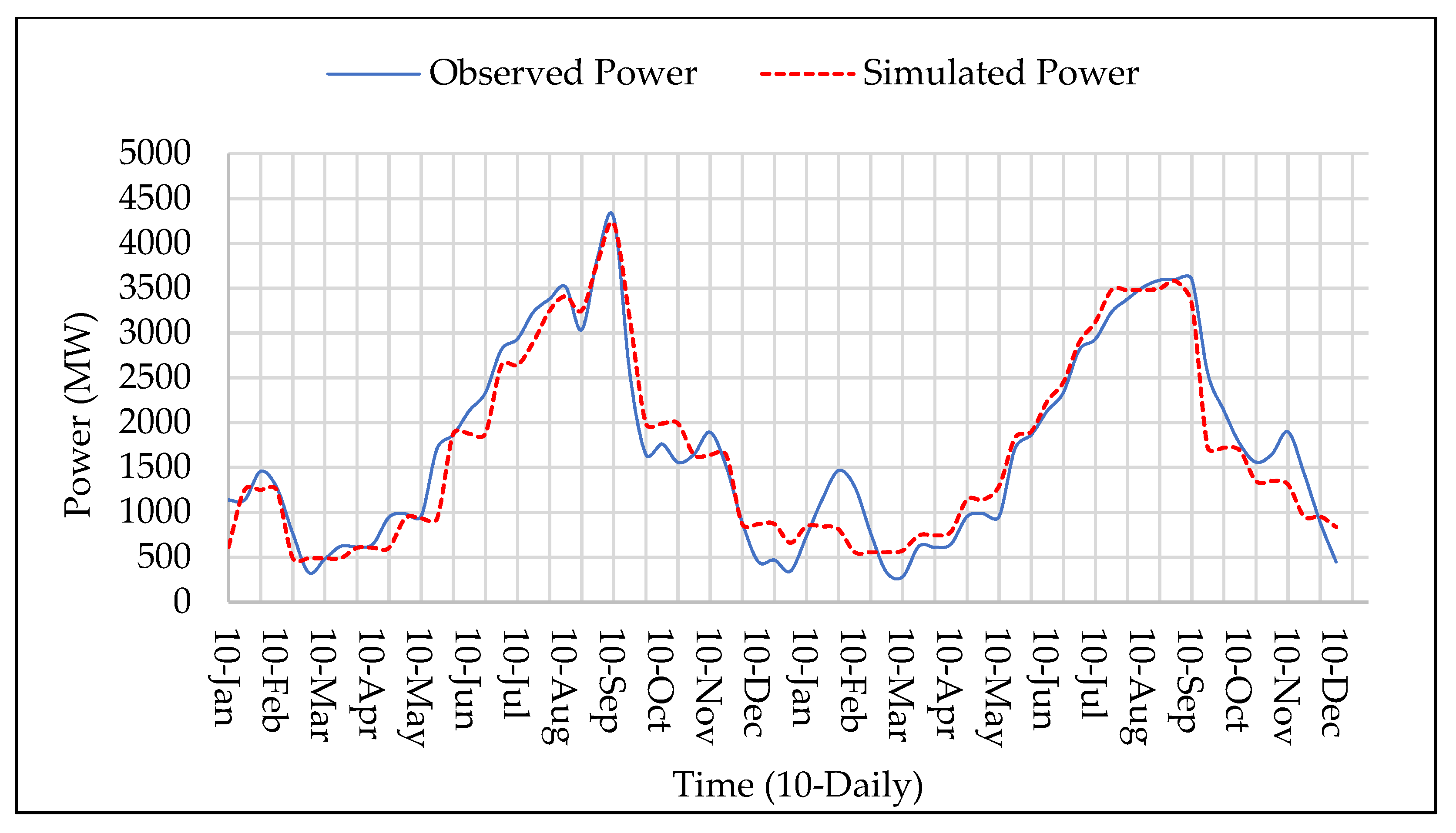
The HEC-ResSim Model was calibrated for the irrigation releases and power generation for the year 2012 and 2013. Results of the Model calibration are indicated in Figure 21 and Figure 22 for irrigation releases and power generation, respectively.
The coefficient of efficiency, index of agreement and run-off ratio indicate the satisfactory values for accuracy of the model as shown in Table 6.
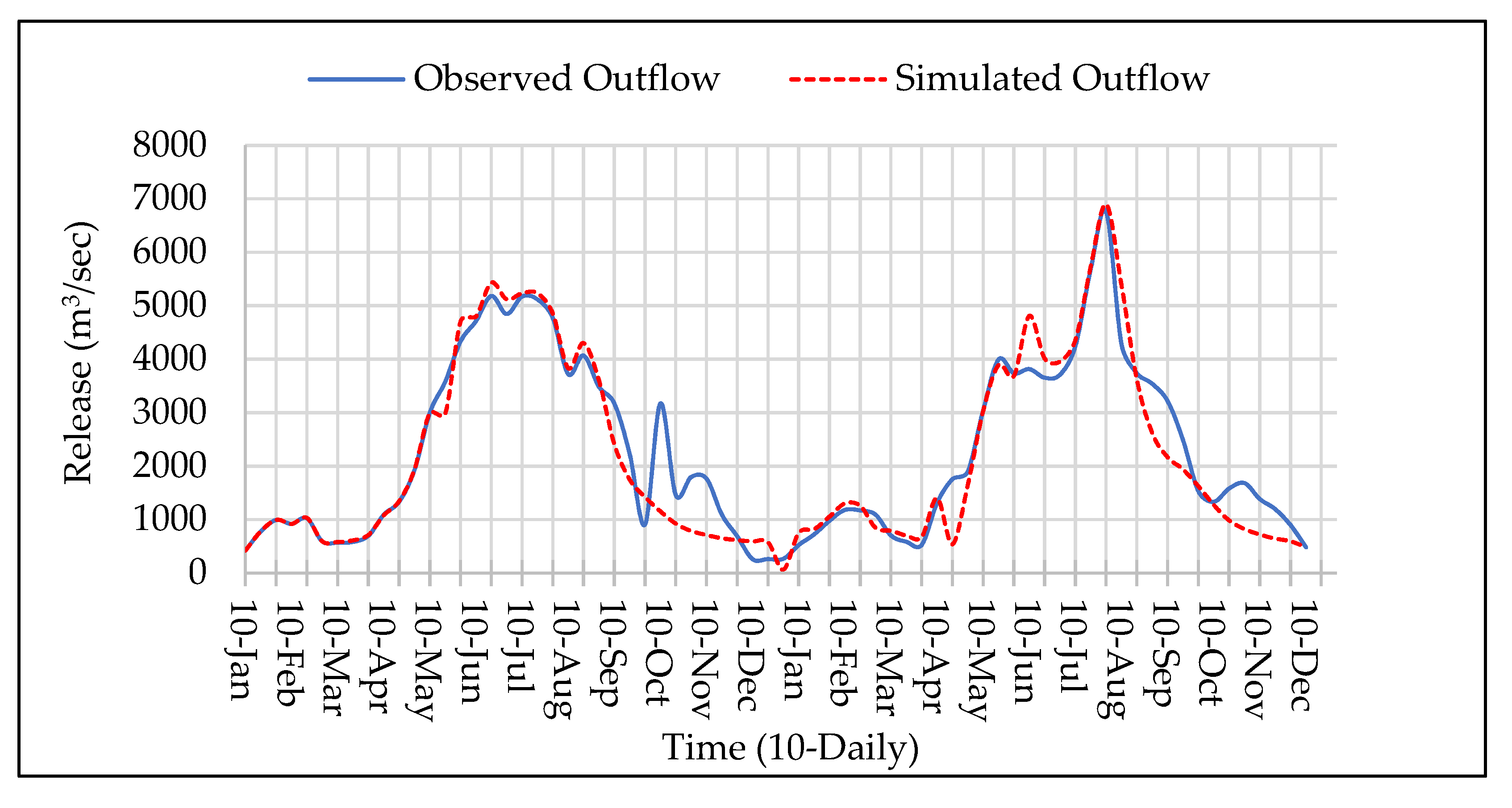
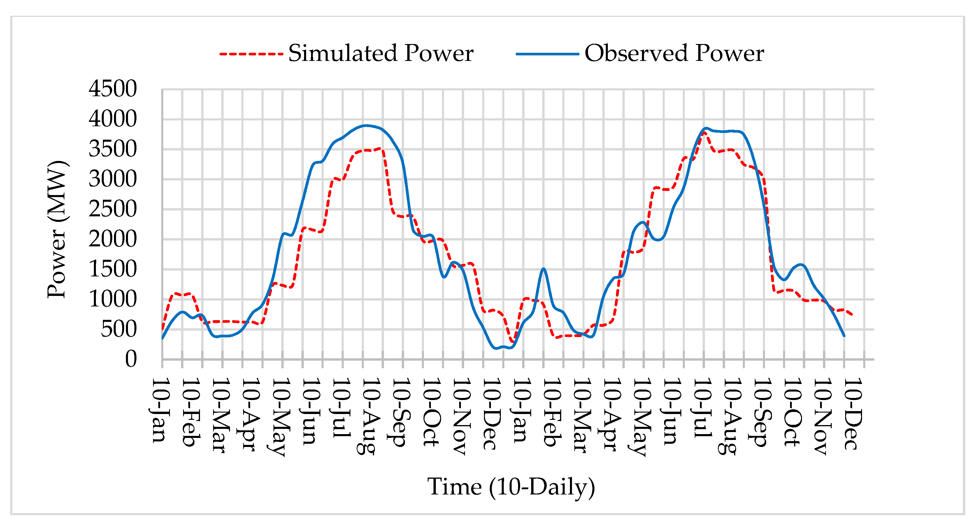
After calibration of the model for the years 2012 and 2013, its validation was carried out using the years 2008 and 2009, see Figure 23 and Figure 24 for irrigation releases and power generation, respectively. The results of validation coincide with the observed value within the satisfactory limits. The resemblance of the simulated values of the model were very closer to the observed values for irrigation releases and power generation, as shown by the IOA, RR and COE in Table 7.
Table 7 shows the quantitative estimation of the deviation between the simulated and observed data. It also includes numerical values of the coefficient of efficiency, index of agreement and run-off ratio also the comparison between the observed and the simulated model for validation of 2008 and 2009.
After the calibration and validation of the model to a satisfactory level, it was employed to predict the possible future irrigation releases and power generation according to WAPDA standard operations procedure. The simulations for predicting future conditions of Tarbela Reservoir were carried out on a 5-year basis for the years 2025, 2030 and 2035 to investigate future irrigation releases, power production and energy generation, as shown in Figure 25, Figure 26 and Figure 27.
With the reduction in storage capacity, the releases during the high inflow period will be more, which will enhance the power production and energy generation as releases are preferred to be passed through the power tunnels.
Application of the model was done on a 5-year basis for 2025, 2030 and 2035. The Tarbela Reservoir was operated according to the existing WAPDA operations for the future years at different minimum operating levels (432.2, 438.2, 444.3 and 450.49 m) and maximum operation level of 472.44 for the year 2025, 2030 and 2035, respectively.
The model was optimized for maximum releases, power, and energy generation according to the modified upper and lower rule curves. When the reservoir capacity is reduced to 20%, then the storage reservoir will be transformed to a run-off-the-river project. The predicted irrigation releases, power, and energy generation of the application model for the year will be reduced, but the power generation and releases from the dam would be maximum (in surplus) during the high flow season.
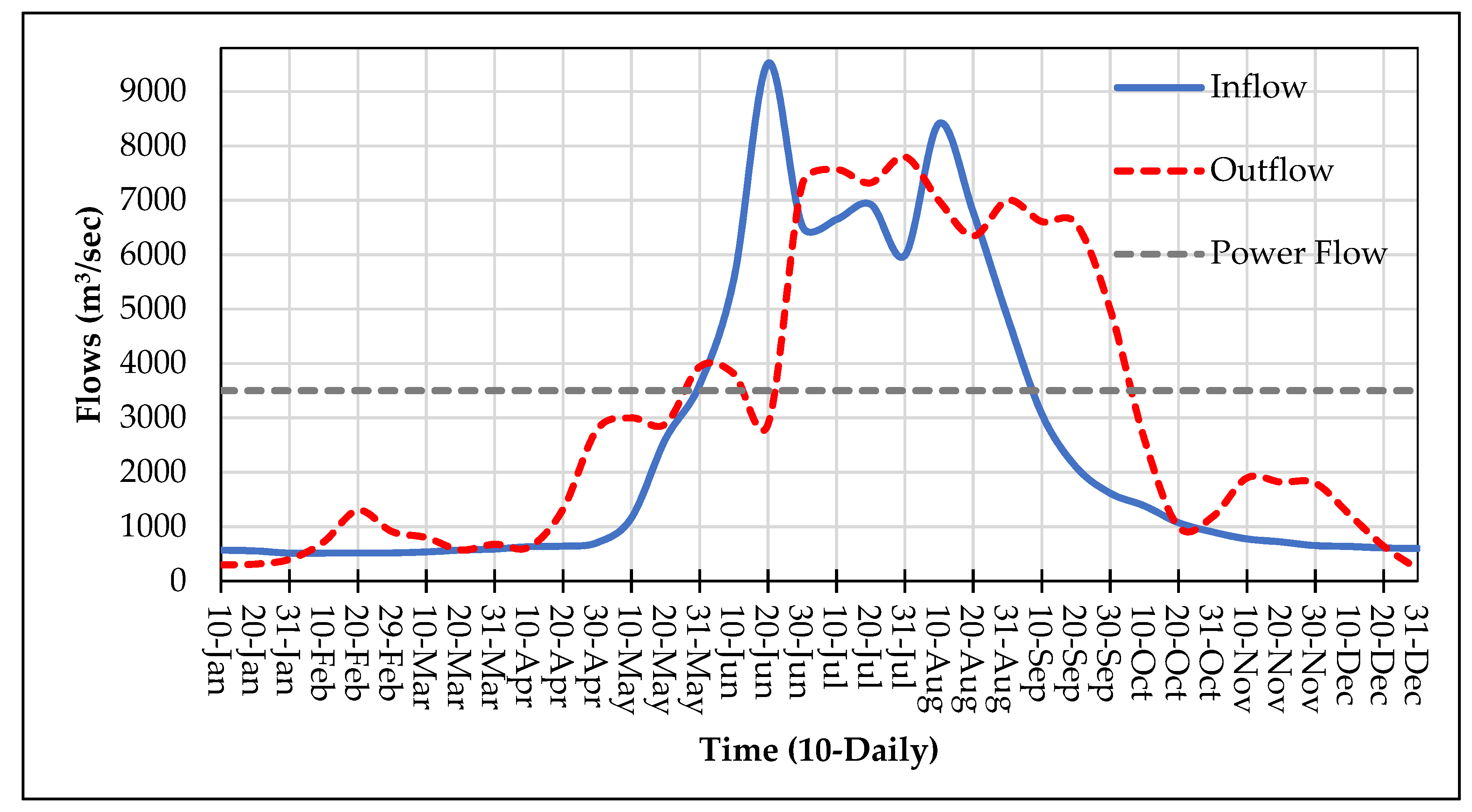
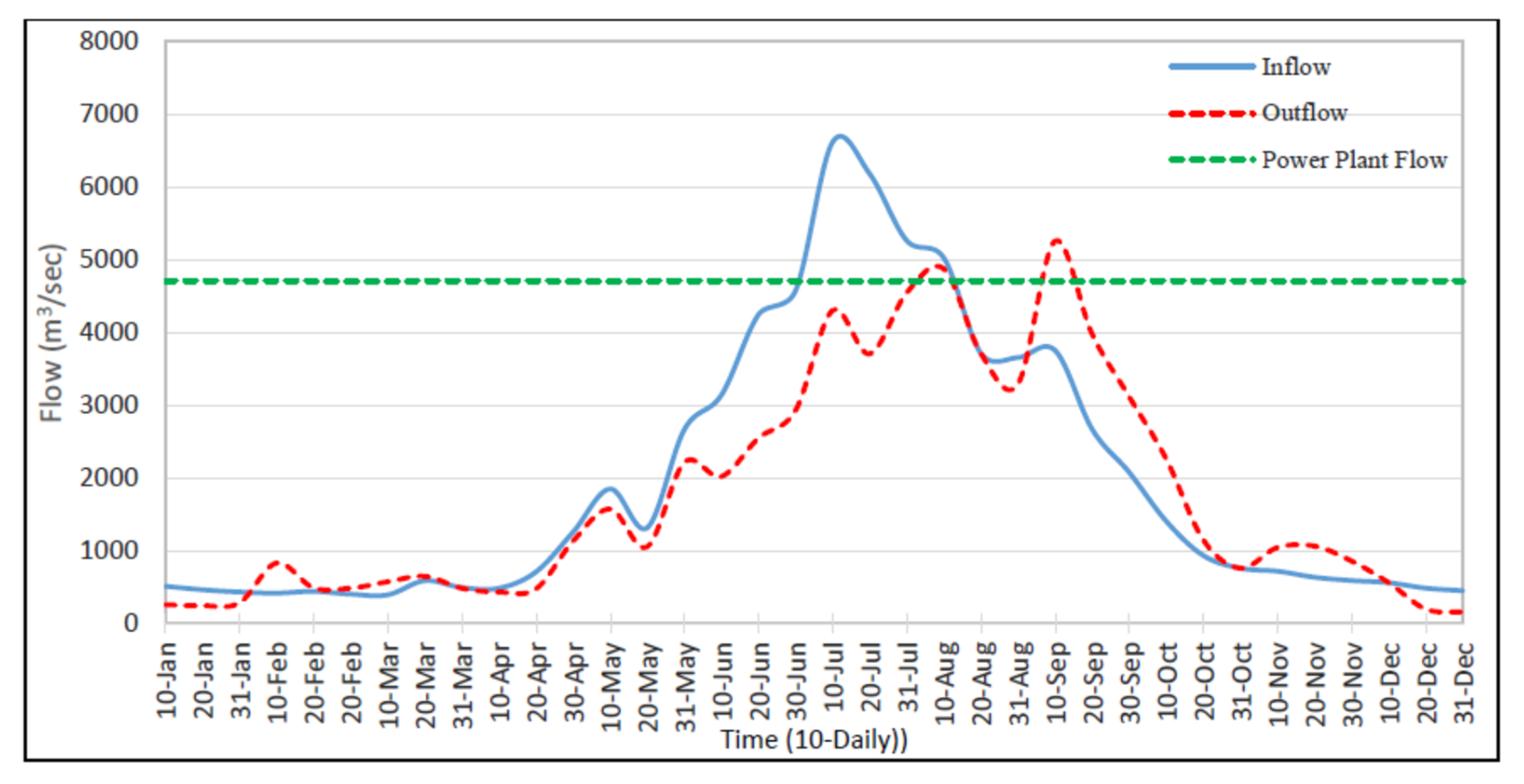
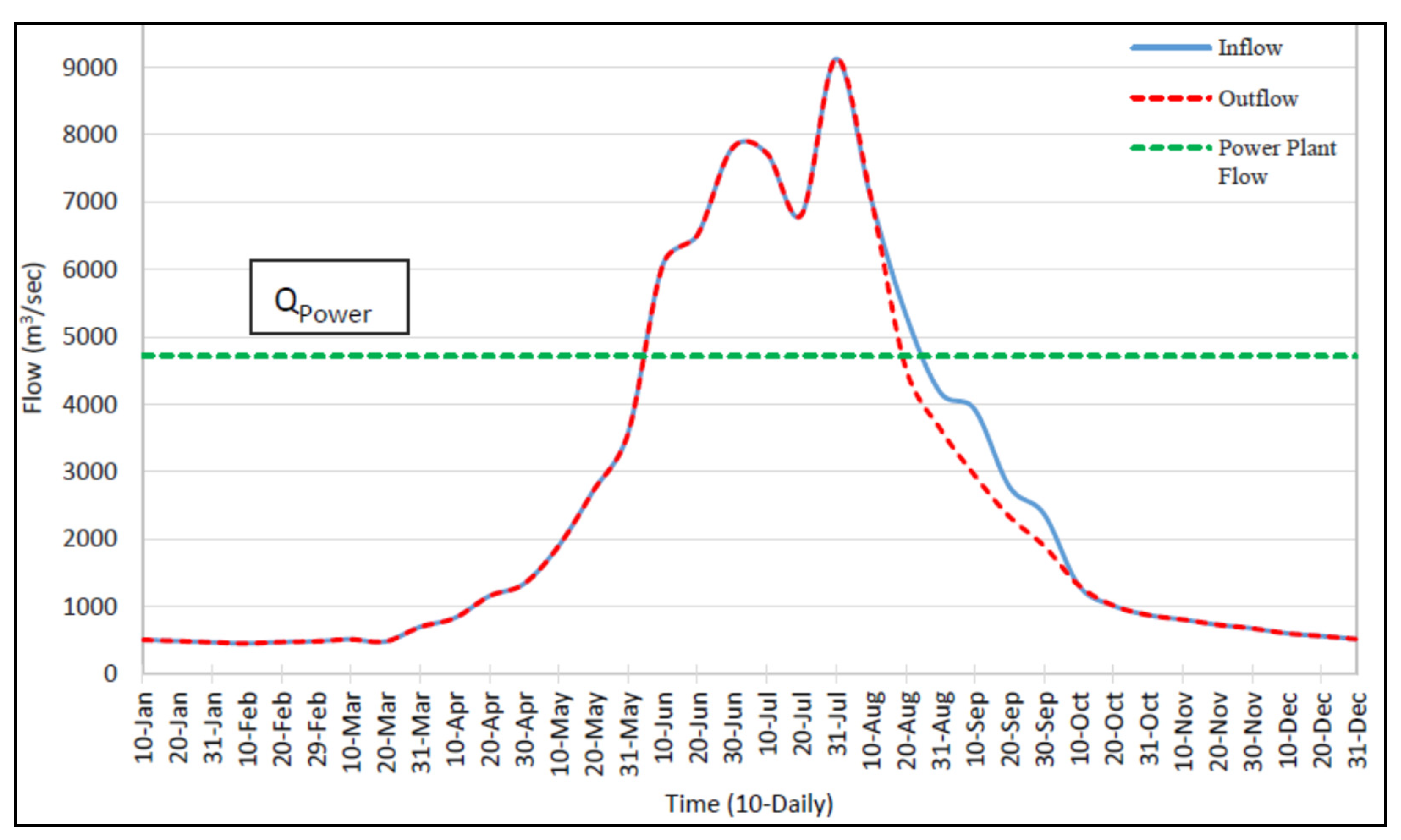
Based on the comparison of inflow and outflow hydrographs of past years (2008, 2009, 2012, 2013) and future years (2025, 2030, 2035), it was observed that there was an increase and decrease in the release patterns in the Kharif and Rabi periods, respectively, by the reduction in storage capacity of the reservoir. As the capacity was reduced due to deposition of high volume of sediments, the releases from the reservoir would increase and up to 2035, it is expected that the inflows would be equal to the outflows from Tarbela (including releases from spillways, irrigation tunnels and power tunnels) due to the reduced storage capacity of 2.87 BCM.
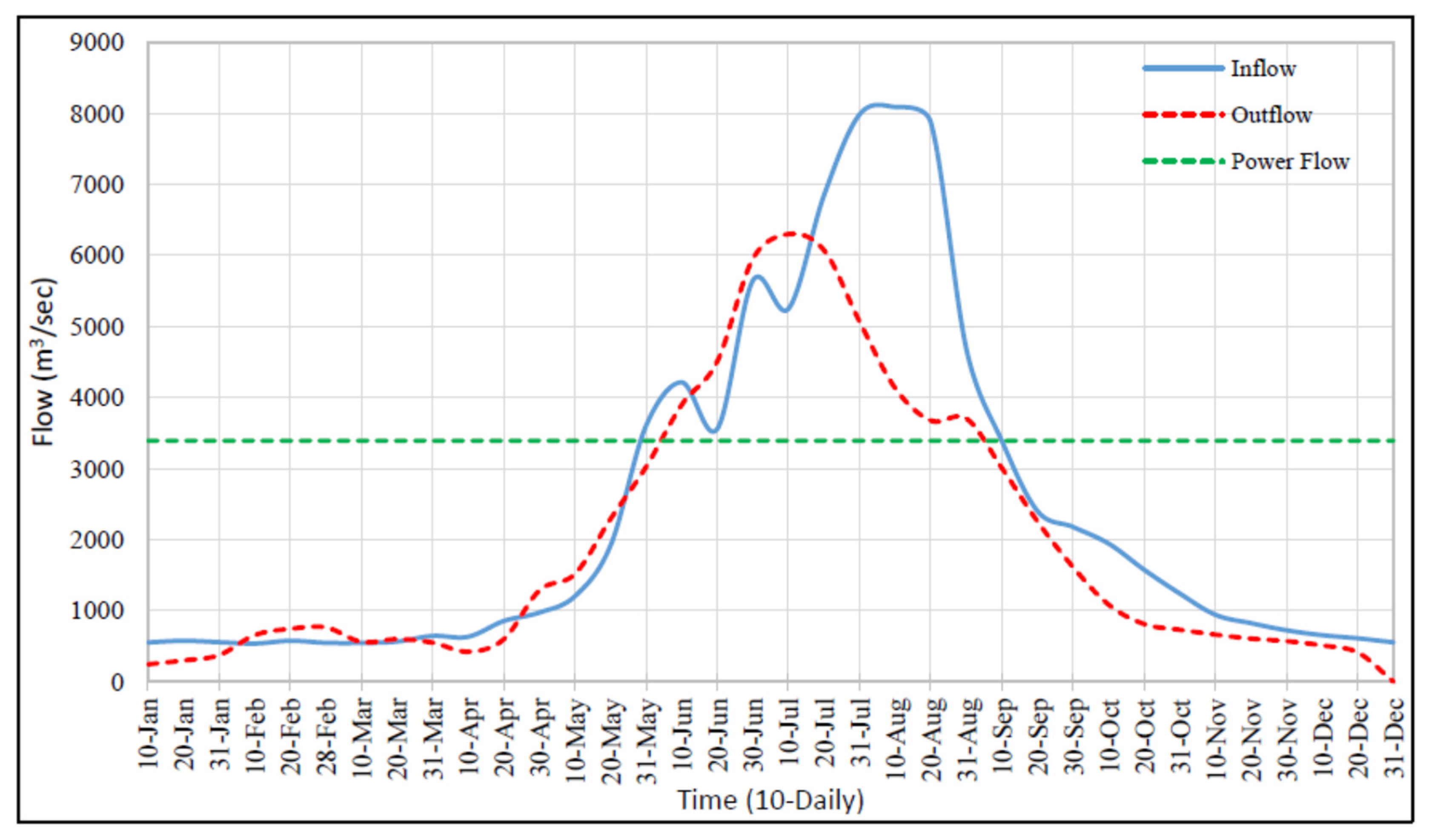
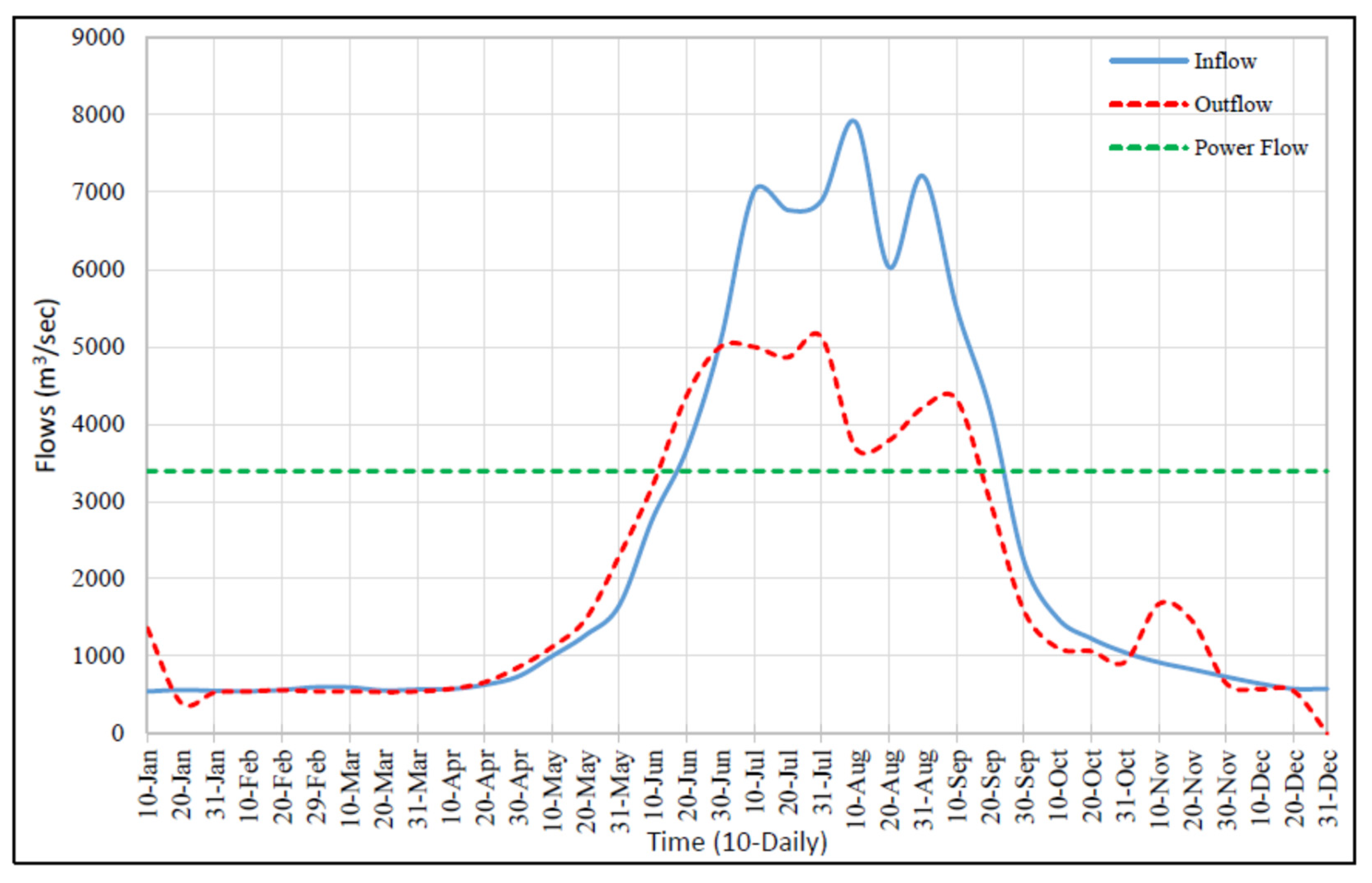
In the past years 2008, 2009, 2012 and 2013, when the storage capacities were 9.932, 9.783, 9.335 and 9.186 BCM, respectively, the storage capacities of Tarbela were enough to operate the reservoir according to the WAPDA standard operation procedures and enough to fulfil the irrigation and power demands d/s of the reservoir throughout the year, as shown in Figure 28, Figure 29, Figure 30 and Figure 31.
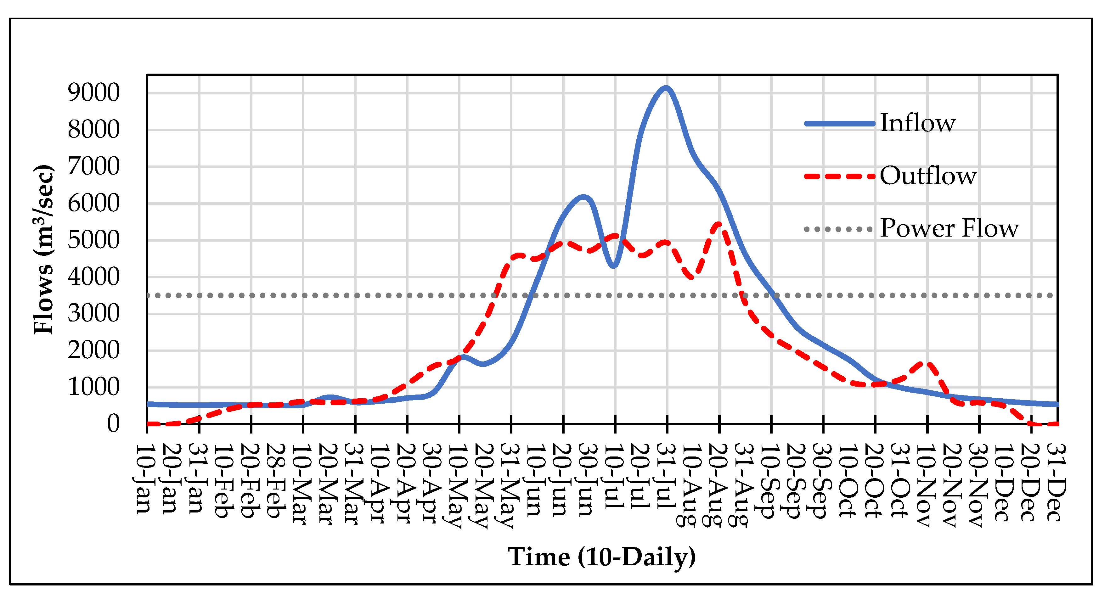
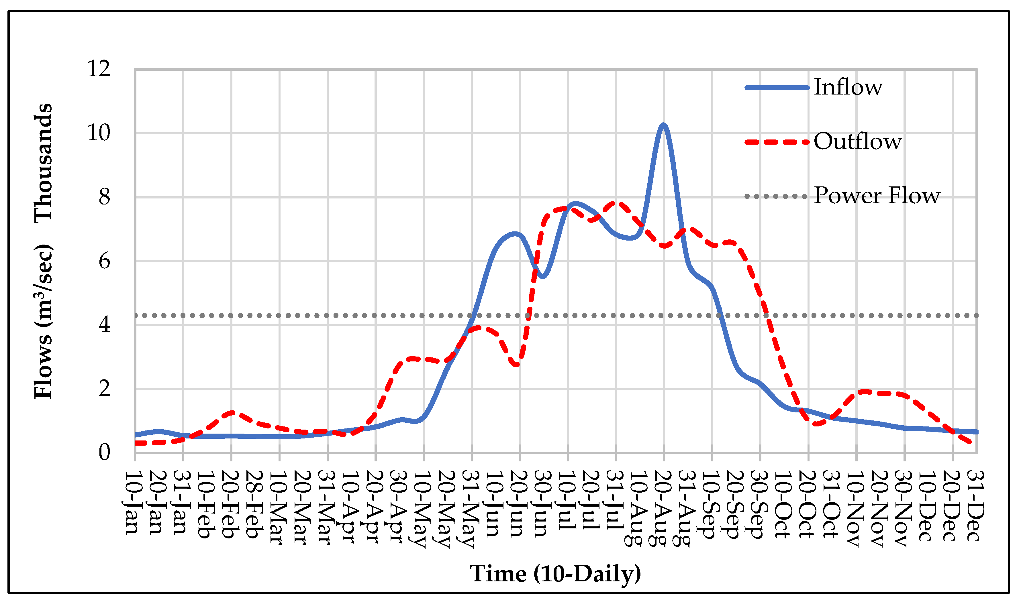
In the future years 2025, 2030 and 2035, when the storage capacities will be 5.855, 5.337 and 2.87 BCM, respectively, the storage capacities of Tarbela would be exhausted such that it would be difficult to operate the reservoir according to the WAPDA standard operation procedures and not enough to fulfil the irrigation and power demands d/s of the reservoir throughout the year, as shown in Figure 32, Figure 33, Figure 34 and Figure 35.
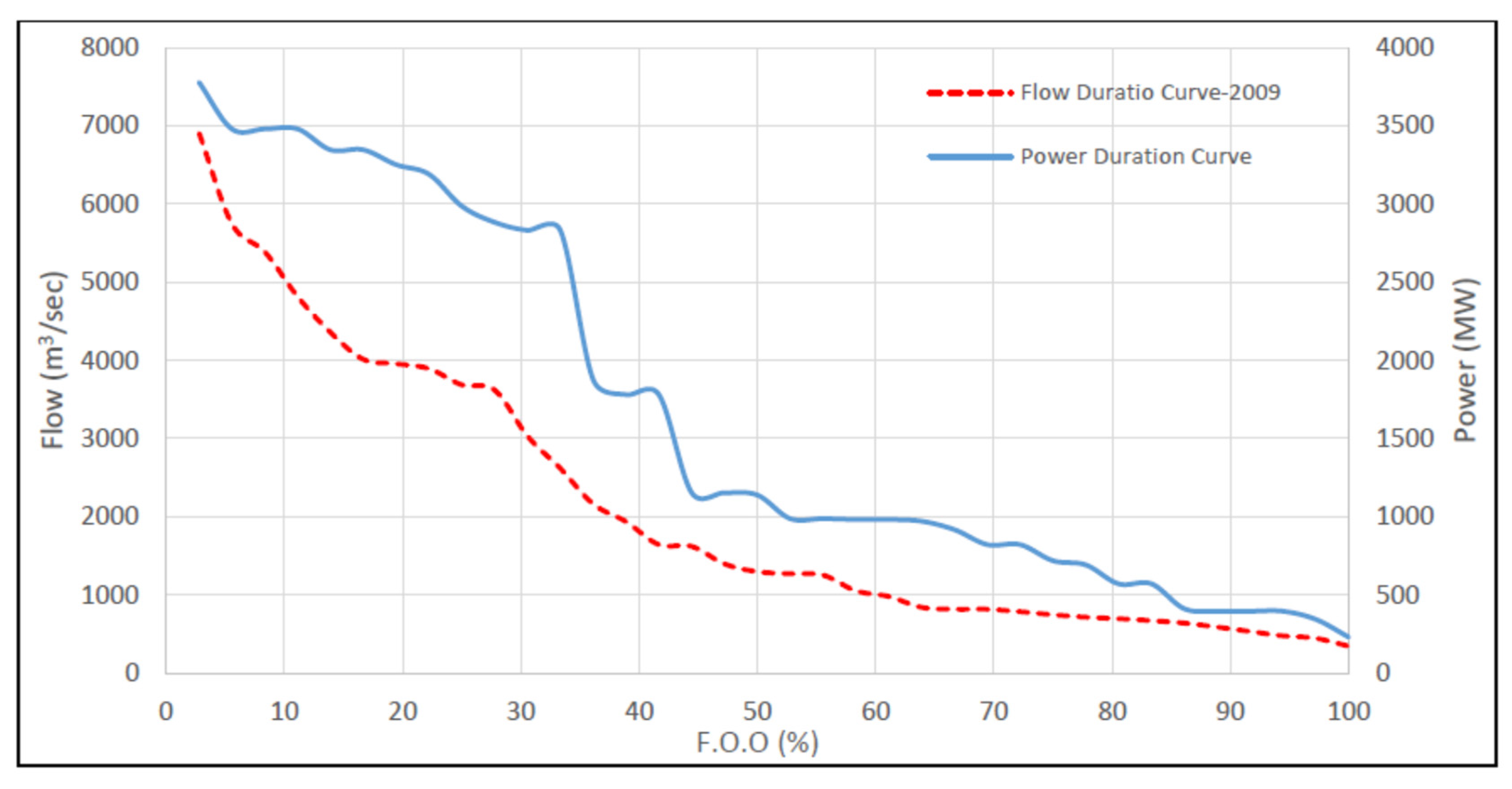
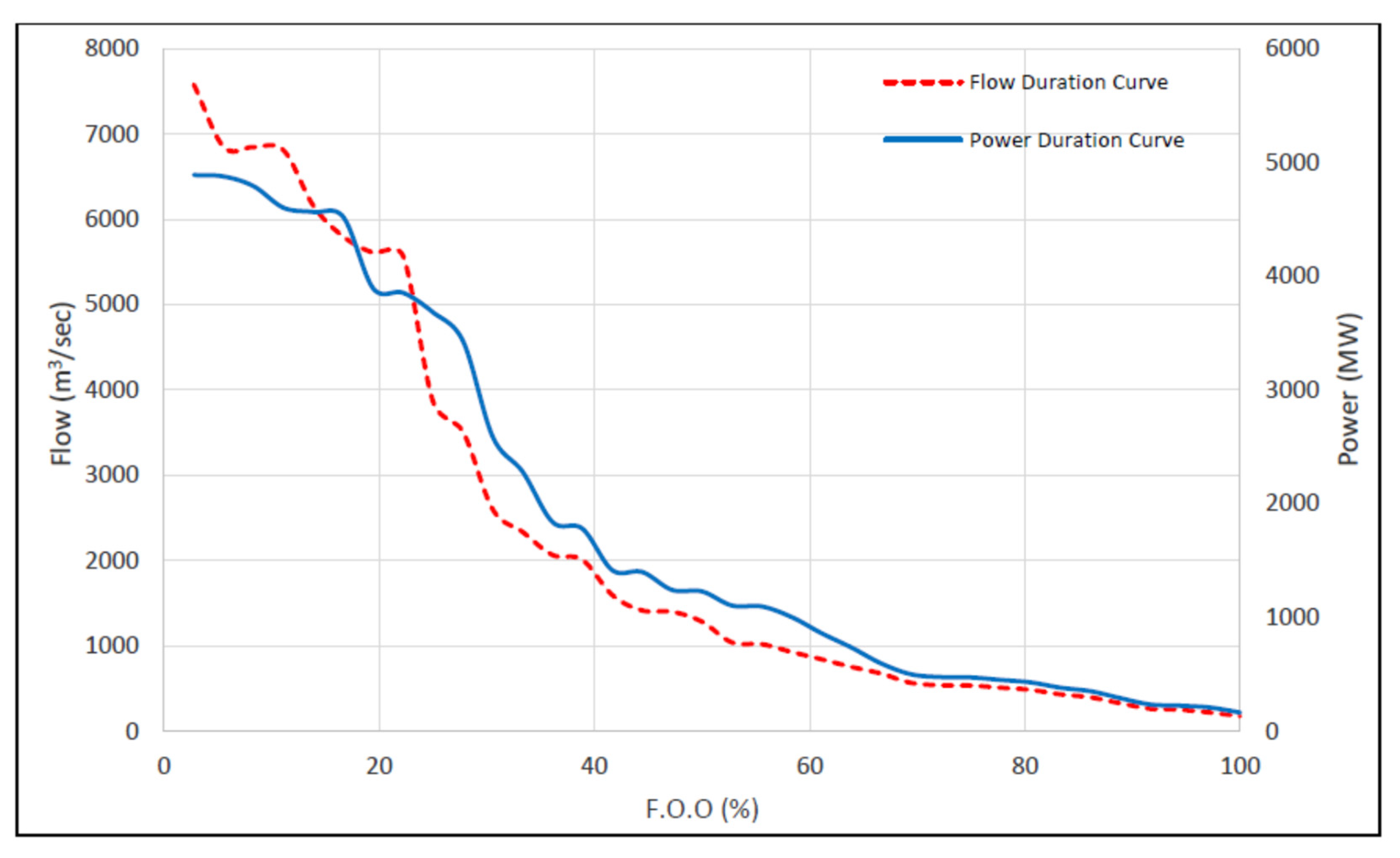
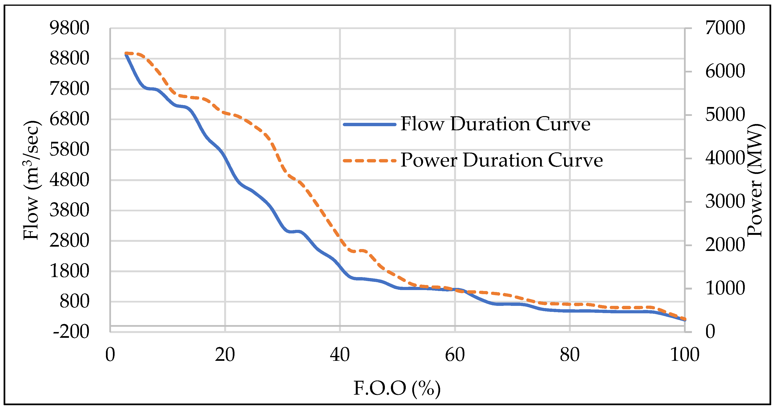
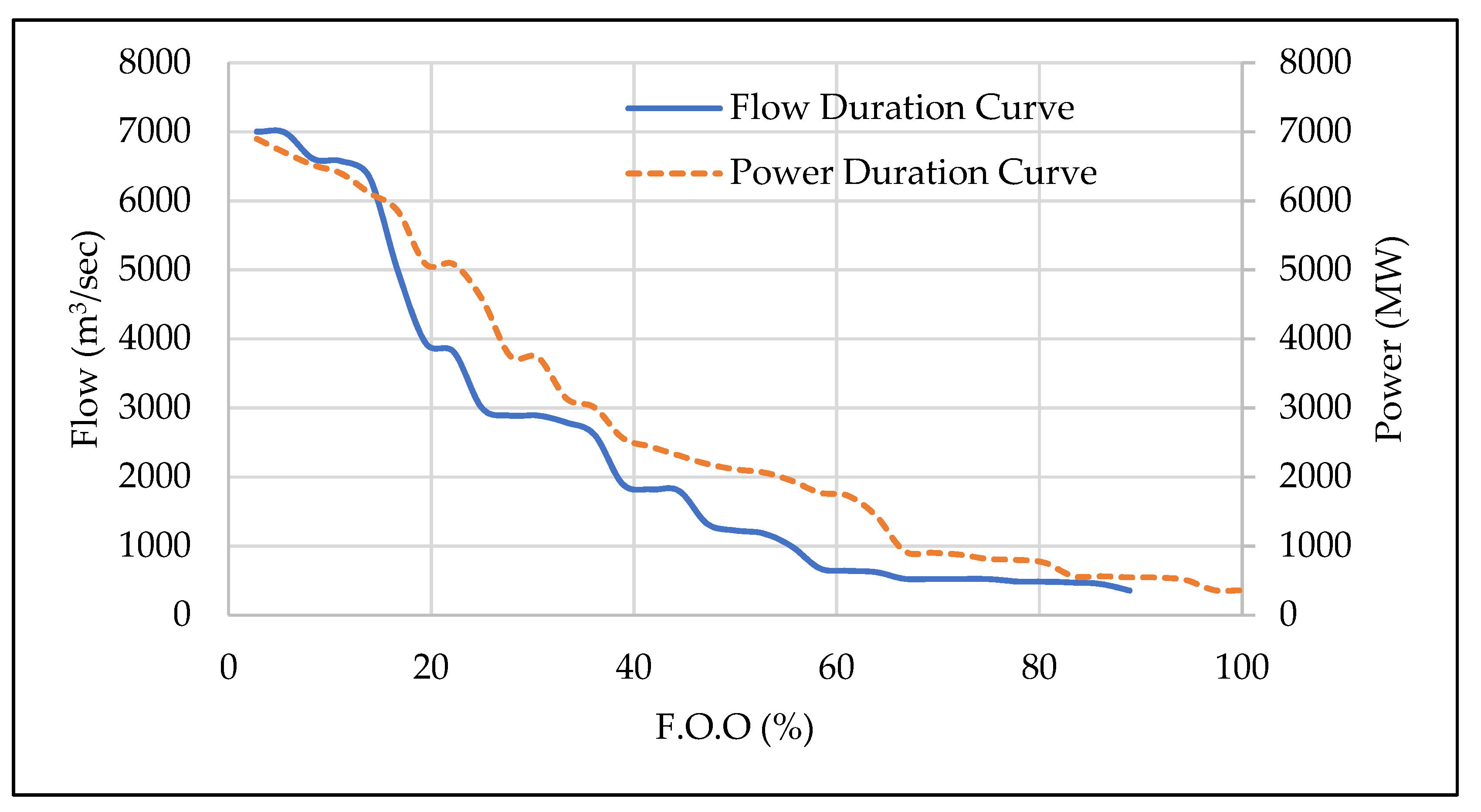
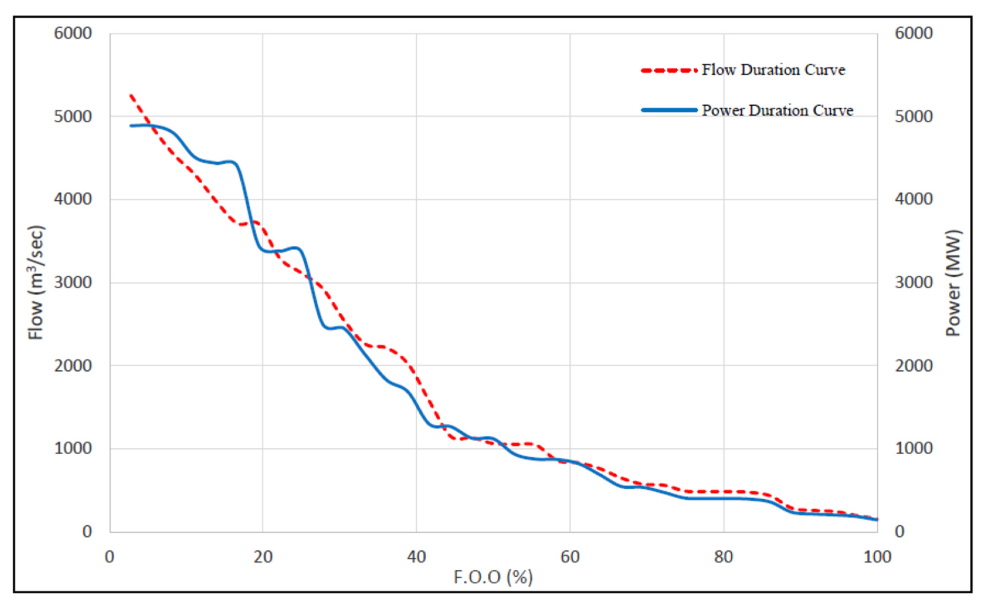
Based on the comparison of flow and power duration curves, as shown in Figure 36, Figure 37 and Figure 38, releases were regulated according to the demand during high, medium, and low flows. However, based on Figure 39, Figure 40 and Figure 41, it can be observed that the flat portion of the flow duration curve predominates, which means that with the passage of time due to the reduction in storage capacity, natural releases would be sustained through the year for river flow regulation, instead of outflows being regulated as per demand as it was in the past years of operation.
The flow and power duration curves of the future application years indicate that the pattern of upper region of both curves in Figure 36, Figure 37 and Figure 38 shows the reservoir would follow the pattern of WAPDA standard operation procedures (when capacity of the reservoir would be enough) and releases and power generation would be according to demand. The medium and lower regions of the flow and power duration curves in Figure 39, Figure 40 and Figure 41 show that, during the low flow season, the inflows in the reservoir would be difficult to fulfil the irrigation and power demand d/s of Tarbela. While the flat pattern of the upper, medium, and lower regions of the flow and power duration curves for year 2035 (when the storage capacity of Tarbela would be expected to fully exhausted) shows in Figure 41 that the inflow would be equal to outflow, and the gross storage would approach 2.87 BCM approximately as shown in Figure 42.
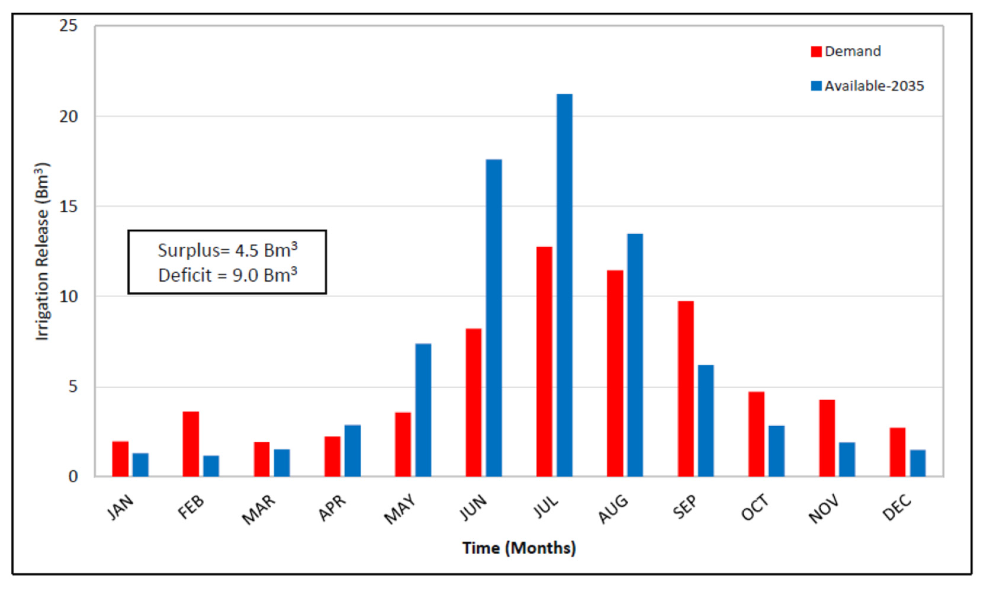
It is observed from Table 8 that the gross storage capacity in year 2035 would be 28% of the original gross storage capacity. This would lead to surplus releases during the kharif season and a deficit in the Rabi season, as demand would be more. The predicted long-lasting irrigation releases in the future year 2035 are shown in Figure 43.
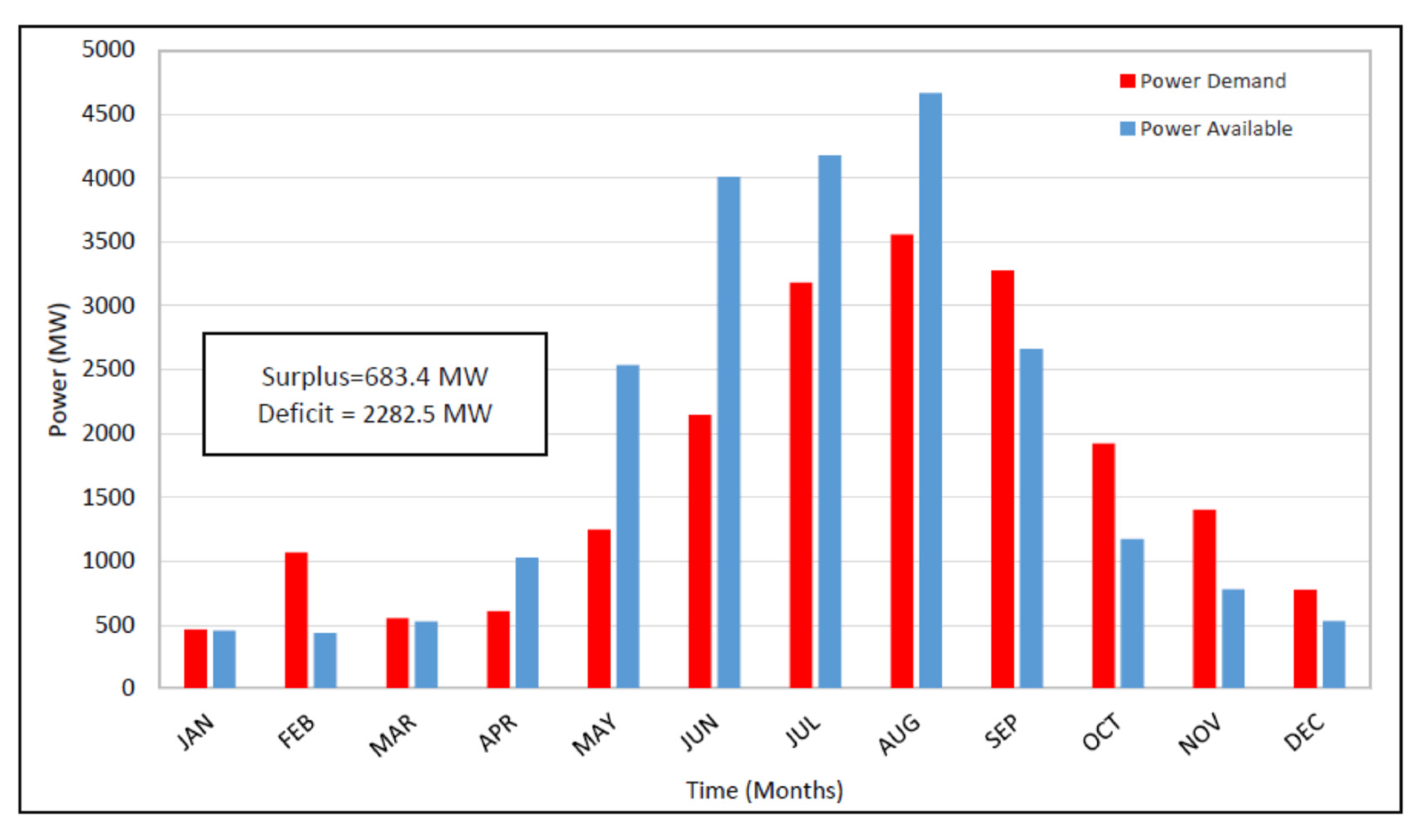
After 2035, when the gross storage capacity of the reservoir would be expected to be fully depleted, the reservoir levels will be higher and most of releases will be preferred to be released through the power tunnels, auxiliary and service spillway. Gross power and energy generation would increase during the high inflow season and will decrease in the low flow season and will not meet the power and energy demand of the country. Power and energy generation would be high in summer season and low during the winter season. The pattern of predicted power and energy generation in 2035 is shown in Figure 44 and Figure 45, respectively.
The simulated results from the study were compared with those of various researchers in the Pakistan region for Tarbela Reservoir [30,31,40,42,45]. The impact on hydropower generation by variation in the operation of Tarbela Reservoir was carried out using the Evaluation and Planning (WEAP) model [42]. It was concluded in that a 13% increase in hydropower generation would be expected by altering the operation and it was recommended that the reliability could be increased or enhanced by restricting releases to through the power units instead of the spillways. Further, it was concluded that shifting of the reservoir level to April-May will raise hydropower generation. However, the study did not compute releases and power generation for future operations. Moreover, the study was devoid of considering impact of sedimentation while altering operational strategies.
The performance assessment of the rule curves for the Tarbela Reservoir was carried out by [45]. Three vital indicators, reliability, resiliency and vulnerability [61], delineating several facets of operational performance, were computed using 44 years of daily time-step dataset from 1976 to 2019. Tradeoff criteria were assessed by earlier researchers [22,62,63] who concluded that the reliability of Tarbela in meeting the irrigation demands could be increased by up to 70% based on present SOPs of WAPDA. The potential impact due to a low performance of Tarbela was evaluated, which entailed that an average annual shortage of 85 MCM was expected to be encountered and this would lead to a reduction in hydropower generation as well. Further, it was demonstrated through intra-annual analysis of maximum and minimum rule curves of Tarbela that maximum variation occurred in the month of April with CV ranges from 0.017 to 0.024 while minimum variation was encountered in August and September with an average CV of 0.003. The greater CV in April showed reduction in performance in fulfilling the downstream demand with a decreasing trend in CV at 0.1% annually [45].
Recently, the RESOOSE model [41] was developed and implemented for maximization of hydropower for cascade reservoirs, i.e., Tarbela and Basha reservoirs. It was concluded that an average annual benefit of 2724 Million US$ by joint operation. Khan et al. developed the ROSSE model [31] for optimization of reservoir operation for Tarbela. It was concluded that while giving priority to hydropower generation, an 8% increase in the net economic benefit may be achieved. In was recommended in the study to establish the model sing HEC-ResSim to validate the results.
Therefore, the present study considered the reservoir operation model coupled with a sediment model. It was found, based on simulation results, that with the predicted reduction in storage capacity, the releases during the high inflow period will be more, which will enhance power production and energy generation as releases would be preferred to be passed through the power tunnels. Application of the model was done on a 5-year basis for the future years 2025, 2030 and 2035. The Tarbela Reservoir was operated according to the existing WAPDA operation procedures for the future years at different minimum operating levels (432.2, 438.2, 444.3 and 450.49 m) and maximum operation level of 472.44 for the year 2025, 2030 and 2035, respectively. The model was optimized for maximum releases, power, and energy generation, according to the modified upper and lower rule curves. The simulated irrigation releases, power, and energy generation of the application model for the year will be reduced but the power generation and releases from the dam would be maximum (in surplus) during the high flow season.
The results of flow and power duration curves for the future application years, see Figure 36, Figure 37 and Figure 38, shows the reservoir would follow the pattern of WAPDA standard operation procedures (when capacity of reservoir would be enough) and releases and power generation would be according to demand. The medium and lower regions of the flow and power duration curves in Figure 39, Figure 40 and Figure 41 shows that during the low-flow season the inflows in the reservoir would be difficult to fulfil the irrigation and power demands d/s of Tarbela. While the flat pattern of the upper, medium, and lower regions of the flow and power duration curves for year 2035 (when the storage capacity of Tarbela would be expected to fully exhausted) shows in Figure 41 that the inflow would be equal to the outflow and the gross storage would approach to 2.87 BCM. The gross power and energy generation would increase during the high inflow season and will decrease in the low flow season and will not meet the power and energy demand of the country. Power and energy generation would be high in the summer season and low during the winter season.
The present simulation study has revealed that while the reservoir consumed 80% of its live storage, power production will be expected to be enhanced during the summer season by 4% and reduced by 37% in the low flow season. However, the impact of gross storage capacity in future will cause a reduction of 6.5% in average annual energy generation because of the limitations imposed by the SOPs of WAPDA being implemented for safely operating the Tarbela dam. The results suggest that with the passage of time, even using optimized rule curves, the reservoir storage capacity will be depleted due to sedimentation.
The flat pattern of the upper, medium, and lower regions of the flow and power duration curves for year 2035 indicate that, by then, the storage capacity of Tarbela would be expected to fully exhausted and inflow would be equal to outflow. The flatness of the flow and power duration curves reinforces the comment that in the month having high flows, inflow becomes equal to outflows due to insufficient storage, while in the low flow season, due to demands higher than inflows, water could not be stored in the reservoir, as irrigation was the primary purpose for construction of the Tarbela reservoir. In 2035, the storage capacity would be exhausted such that it would be difficult to operate the reservoir according to WAPDA standard operation procedures and releases will not be sufficient to meet the irrigation demands throughout the year.
12. Conclusions

In this study, the HEC-ResSim model for Tarbela Reservoir was developed for analysing historic and future reservoir operations considering sedimentation impact using the HEC-RAS sediment model. The constraint of the SOPs implemented by WAPDA are also outlined and modelled in the HEC-ResSim. The new developed methodology was simulated for the Tarbela reservoir, Pakistan for assessment of its future operation. After successful calibration and validation, the model was used for future operation prediction at 5-year intervals, as the reservoir lost 80% of its live storage capacity. The results were then discussed in the context of pre-existing research, by taking existing WAPDA SOPs into account. In addition, future flow duration and power duration curves were developed to discuss the impact of releases through the reservoir during the Rabi (October–March) and Kharif (April–September) seasons. The simulated results will be helpful for policy makes/water managers in deciding flexibility in system constraints.
Based on the results, the following conclusions were made:
  • The simulation results showed that a flat pattern of the upper, medium, and lower region of the flow and power duration curves for the year 2035 indicate when the storage capacity of Tarbela would be expected to fully exhausted and inflow would be equal to outflow. After 2035, Tarbela Reservoir is expected to become a run-of-the-river type project (when reservoir capacity will be exhausted by 80%), and the irrigation releases are likely to be enhanced during Kharif and reduced in Rabi by 7 and 50%, respectively.
  • Based on the scenarios considered in the simulations, the study shows that the power generation is expected to be enhanced during Kharif and reduced in Rabi by 4 and 37%, respectively after 2035.
  • In future, when the project will become the run-off-the-river type, energy generation are likely to increase during Kharif and decrease during Rabi by 36 and 37%, respectively.
  • The impact of reduction in the gross storage capacity of the Tarbela Reservoir in future upon implementation of the WAPDA existing standard operating procedures may result in reducing average annual energy generation by 6.5%.

13. Recommendations

The following recommendations are for the future expected scenario.
  • As in future, when the Tarbela Reservoir will become ineffective for fulfilling the water demands during Rabi and the power demand in the winter season, to achieve sustainable development goals, the construction of the Diamer Basha dam and Kala Bagh dam should be initiated to fulfil the irrigation releases and power generation shortages in future.
  • The use of innovative efficient irrigation systems is recommended for the low flow season, which will alleviate poverty, improving living and sustainable communities.
  • The impact of reservoir storage capacity on future irrigation releases, power and energy should be investigated considering mean daily flows and daily power.
  • The HEC-ResSim model may be applied daily for the future irrigation releases, power and energy assessment.
  • The impact of climate change on future inflows and demands needs to be considered for future research work.

Author Contributions

Conceptualization, H.-U.R.; Data curation, M.M.M.; Formal analysis, M.M.M.; Literature Review, M.M.M.; Methodology, M.M.M.; Project administration, N.M.K. and M.K.S.; Resources, M.U.R.; Software, M.M.M.; Supervision, A.S.S.; Writing—original draft, M.M.M.; Writing—review & editing, M.A.-U.-R.T.; Funding acquisition, M.A.-U.-R.T. All authors have read and agreed to the published version of the manuscript.

Funding

This research work has received no external funding however, the APC was funded by Charles Darwin University.

Data Availability Statement

This study did not report any data.

Acknowledgments

We are grateful to various departments i.e., IRSA, WAPDA, PMD for provision of dataset and continued support for the fulfilment of this research. We are also thankful to Charles Darwin University for providing funding.

Conflicts of Interest

There is no conflict of interest in the present research.

References

  1. Chaudhry, M.A.; Rehman, H.-U. Worldwide Experience of Sediment Flushing Through Reservoirs. Mehran Univ. Res. J. Eng. Technol. 2012, 31, 395–408. [Google Scholar]
  2. International Commissionon Large Dams. World Register of Dams. Int. Comm. Large Dams 2020, I, 2–12. [Google Scholar]
  3. Palmieri, A.; Annandale, G.W.; Dinar, A.; Johndrow, T.B.; Kawashima, S.; Shah, F. RESCON Approach; World Bank: Washington, DC, USA, 2003. [Google Scholar]
  4. Annandale, G. Quenching the Thirst. Sustainable Water Supply and Climate Change; Createspace Independent Publishing Platform: Scotts Valley, CA, USA, 2013. [Google Scholar]
  5. Juracek, K.E. The Aging of America’s Reservoirs: In-Reservoir and Downstream Physical Changes and Habitat Implications. JAWRA J. Am. Water Resour. Assoc. 2015, 51, 168–184. [Google Scholar] [CrossRef]
  6. Kondolf, G.M.; Gao, Y.; Annandale, G.W.; Morris, G.L.; Jiang, E.; Zhang, J.; Cao, Y.; Carling, P.; Fu, K.; Guo, Q.; et al. Sustainable Sediment Management in Reservoirs and Regulated Rivers: Experiences from Five Continents. Earth’s Future 2014, 2, 256–280. [Google Scholar] [CrossRef]
  7. Morris, G.L.; Fan, J. Reservoir Sedimentation Handbook; Aging: Albany, NY, USA, 1998. [Google Scholar]
  8. Graf, W.L.; Wohl, E.; Sinha, T.; Sabo, J.L. Erratum: Sedimentation and Sustainability of Western American Reservoirs (Water Resources Research (2011) 47 (W08901). Water Resour. Res. 2011, 47, W08901. [Google Scholar] [CrossRef]
  9. Tate, E.L.; Farquharson, F.A.K. Simulating Reservoir Management under the Threat of Sedimentation: The Case of Tarbela Dam on the River Indus. Water Resour. Manag. 2000, 14, 191–208. [Google Scholar] [CrossRef]
  10. Sabir, M.A.; Shafiq-Ur-Rehman, S.; Umar, M.; Waseem, A.; Farooq, M.; Khan, A.R. The Impact of Suspended Sediment Load on Reservoir Siltation and Energy Production: A Case Study of the Indus River and Its Tributaries. Pol. J. Environ. Stud. 2013, 22, 219–225. [Google Scholar]
  11. Atkinson, E. Reservoir Operation to Control Sedimentation: Techniques for Assessment. In The Prospect for Reservoirs in the 21st Century; Thomas Telford Ltd.: London, UK, 1998. [Google Scholar] [CrossRef]
  12. Attewill, L.J.S.; White, W.R.; Tariq, S.M.; Bilgi, A. Sediment Management Studies of Tarbela Dam, Pakistan. In The Prospect for Reservoirs in the 21st Century; Thomas Telford Ltd.: London, UK, 1998. [Google Scholar] [CrossRef]
  13. Roca, M. Tarbela Dam in Pakistan. Case Study of Reservoir Sedimentation. In Proceedings of the River Flow 2012–Proceedings of the International Conference on Fluvial Hydraulics, San José, CA, USA, 5–7 September 2012. [Google Scholar]
  14. WAPDA. Tarbela Dam Project-Sixth Periodic Inspection Report; DSO, WAPDA: Lahore, Pakistan, 2018. [Google Scholar]
  15. Rehman, H.-U.; Rehman, M.A.; Naeem, U.A.; Hashmi, H.N.; Shakir, A.S. Possible Options to Slow down the Advancement Rate of Tarbela Delta. Environ. Monit. Assess. 2018, 190, 39. [Google Scholar] [CrossRef] [PubMed]
  16. The World Bank. Tarbela Fourth Extension Hydropower Project; The World Bank: Washington, DC, USA, 2022; pp. 1–9. [Google Scholar]
  17. WAPDA. Annual Report 2016–2017; WAPDA: Lahore, Pakistan, 2017.
  18. WAPDA. Annual Report 2017–2018; WAPDA: Lahore, Pakistan, 2018.
  19. WAPDA. Annual Report 2018–2019; WAPDA: Lahore, Pakistan, 2019.
  20. WCD. Dams and Development–A New Framework for Decision Making; Earthscan Publications Ltd.: London, UK; Sterling, VA, USA, 2000. [Google Scholar]
  21. The World Commission on Dams. Available online: https://energypedia.info/wiki/World_Commission_on_Dams_(WCD)_Report (accessed on 13 June 2022).
  22. Moy, W.-S.; Cohon, J.L.; ReVelle, C.S. A Programming Model for Analysis of the Reliability, Resilience, and Vulnerability of a Water Supply Reservoir. Water Resour. Res. 1986, 22, 489–498. [Google Scholar] [CrossRef]
  23. Vogel, R.M.; Bolognese, R.A. Storage-Reliability-Resilience-Yield Relations for Over-Year Water Supply Systems. Water Resour. Res. 1995, 31, 645–654. [Google Scholar] [CrossRef]
  24. Lutz, A.F.; Immerzeel, W.W.; Shrestha, A.B.; Bierkens, M.F.P. Consistent Increase in High Asia’s Runoff Due to Increasing Glacier Melt and Precipitation. Nat. Clim. Chang. 2014, 4, 587–592. [Google Scholar] [CrossRef]
  25. Wang, W.; Xiang, Y.; Gao, Y.; Lu, A.; Yao, T. Rapid Expansion of Glacial Lakes Caused by Climate and Glacier Retreat in the Central Himalayas. Hydrol. Process. 2015, 29, 859–874. [Google Scholar] [CrossRef]
  26. Khan, A.J.; Koch, M. Selecting and Downscaling a Set of Climate Models for Projecting Climatic Change for Impact Assessment in the Upper Indus Basin (UIB). Climate 2018, 6, 89. [Google Scholar] [CrossRef]
  27. Yu, W.; Yang, Y.-C.; Savitsky, A.; Alford, D.; Brown, C.; Wescoat, J.; Debowicz, D.; Robinson, S. The Indus Basin of Pakistan; World Bank Group: Washington, DC, USA, 2013. [Google Scholar] [CrossRef]
  28. Hunt, J.R.; Lilley, J.M.; Trevaskis, B.; Flohr, B.M.; Peake, A.; Fletcher, A.; Zwart, A.B.; Gobbett, D.; Kirkegaard, J.A. Early Sowing Systems Can Boost Australian Wheat Yields despite Recent Climate Change. Nat. Clim. Chang. 2019, 9, 244–247. [Google Scholar] [CrossRef]
  29. Hassan, D.; Rais, M.N.; Ahmed, W.; Bano, R.; Burian, S.J.; Ijaz, M.W.; Bhatti, F.A. Future Water Demand Modeling Using Water Evaluation and Planning: A Case Study of the Indus Basin in Pakistan. Sustain. Water Resour. Manag. 2019, 5, 1903–1915. [Google Scholar] [CrossRef]
  30. Rashid, M.U.; Latif, A.; Azmat, M. Optimizing Irrigation Deficit of Multipurpose Cascade Reservoirs. Water Resour. Manag. 2018, 32, 1675–1687. [Google Scholar] [CrossRef]
  31. Khan, N.M.; Babel, M.S.; Tingsanchali, T.; Clemente, R.S.; Luong, H.T. Reservoir Optimization-Simulation with a Sediment Evacuation Model to Minimize Irrigation Deficits. Water Resour. Manag. 2012, 26, 3173–3193. [Google Scholar] [CrossRef]
  32. Joan, D.; Klipsch, M.B.; Hurst, G.C.; Modini, D.L.; Black, S.M.O. HEC-ResSim_33_UsersManual.Pdf; US Army Corps of Engineers Institute for Water Resources Hydrologic Engineering Center (HEC): Davis, CA, USA, 2021; p. 670. [Google Scholar]
  33. Babazadeh, H.; Sedghi, H.; Kaveh, F. Performance Evaluation of Jiroft Storage Dam Operation Using Hec-Ressim 2.0. Water Resour. 2007, I, 449–459. [Google Scholar]
  34. Gebresenbet, T.S. Modeling of Cascade Dams and Reservoirs Operation for Optimal Water Use: Application to Omo Gibe River Basin, Ethiopia; Kassel University Press GmbH: Kassel, Germany, 2015. [Google Scholar]
  35. Approved, F.; No, O.M.B.; Needham, J. Water Balance and Regulation Alternative Analysis for Kajakai Reservoir Using HEC-ResSim Phase I and II Final Report. 2007. Available online: www.hec.usace.army.mil (accessed on 27 March 2022).
  36. McKinney, D.C. HEC ResSim Model of Lancang Cascade Dams. 2011, pp. 1–9. Available online: https://www.google.com.hk/url?sa=t&rct=j&q=&esrc=s&source=web&cd=&ved=2ahUKEwjMwafv_8f5AhW2RmwGHZhNBasQFnoECAMQAQ&url=https%3A%2F%2Fn-h-i.org%2Fwp-content%2Fuploads%2F2017%2F02%2FMcKinney__HEC_ResSim_Model_of_Lancang_Cascade_Dams.pdf&usg=AOvVaw1bCDfwZxOXtpocc0GeAmzR (accessed on 27 March 2022).
  37. Jebbo, B.A.; Awchi, T.A. Simulation Model for Mosul Dam Reservoir Using HEC-ResSim 3.0 Package. Zanco J. Pure Appl. Sci. 2016, 28, 92–98. [Google Scholar]
  38. Lara, P.G.; Lopes, J.D.; Luz, G.M.; Bonumá, N.B. Reservoir Operation Employing HEC-ResSim: Case Study of Tucuruí Dam. In Proceedings of the Brazil, 6th International Conference on Flood Management (ICFM6), São Paulo, Brazil, 16–18 September 2014. [Google Scholar]
  39. Mahmood, R. Assessment of Climate Change Impact on Water Resources and Hydropower in the Jhelum River Basin, Pakistan. Ph.D. Thesis, Asian Institute of Technology, Pathum Thani, Thailand, 2013. [Google Scholar]
  40. Rashid, M.U.; Shakir, A.S.; Khan, N.M. Evaluation of Sediment Management Options and Minimum Operation Levels for Tarbela Reservoir, Pakistan. Arab. J. Sci. Eng. 2014, 39, 2655–2688. [Google Scholar] [CrossRef]
  41. Rashid, M.U.; Abid, I.; Latif, A. Optimization of Hydropower and Related Benefits through Cascade Reservoirs for Sustainable Economic Growth. Renew. Energy 2022, 185, 241–254. [Google Scholar] [CrossRef]
  42. Rafique, A.; Burian, S.; Hassan, D.; Bano, R. Analysis of Operational Changes of Tarbela Reservoir to Improve the Water Supply, Hydropower Generation, and Flood Control Objectives. Sustainability 2020, 12, 7822. [Google Scholar] [CrossRef]
  43. Sustainable Development Goals United Nations Development Programme. Available online: https://www.undp.org/sustainable-development-goals (accessed on 13 June 2022).
  44. Haq, I.; Abbas, S.T. Sedimentation of Tarbela & Mangla Reservoirs. In Pakistan Engineering Congress 70th Annual Session Proceedings Paper. No 659 2008; PE Congress; Lahore, Pakistan, 2008; pp. 25–46.
  45. Munir, M.M.; Shakir, A.S.; Rehman, H.-U.; Khan, M.U.R.N.M. Assessment of Operation Rules in Reservoir Systems–A Case Study of Tarbela & Mangla. Fresenius Environ. Bull. 2022, 31, 2914–2934. [Google Scholar]
  46. Klipsch, J.D.; Hurst, M.B. HEC-ResSim Reservoir System Simulation User’s Manual Version 3.1. 2013. No. CPD-82, 556. Available online: www.hec.usace.army.mil (accessed on 27 March 2022).
  47. Mujahid, H. Enhancement of Tarbela Reservoir Life; University of Engg. & Tech.: Lahore, Pakistan, 2013; pp. 76–83. [Google Scholar]
  48. Mazhar, N.; Mirza, A.I.; Butt, Z.S.; Nawaz, M.; Ameer, M.; Akram, N. Advancement of the Pivot Point of Underwater Delta: A Study of Tarbela. J. Himal. Earth Sci. 2021, 54, 40–46. [Google Scholar]
  49. Wesley, M. Energy Security in Asia. In Energy Security in Asia; Routledge: London, UK, 2006; pp. 1–251. [Google Scholar] [CrossRef]
  50. Ahmed, K.B.; Sanchez, M. A Study of the Factors and Processes Involved in the Sedimentation of Tarbela Reservoir, Pakistan. Environ. Earth Sci. 2011, 62, 927–933. [Google Scholar] [CrossRef]
  51. WAPDA. Flood Management Manual. In Survey & Hydrology, Tarbela Dam Project (TDP); WAPDA: Lahore, Pakistan, 2011. [Google Scholar]
  52. Wurbs, R.A. Institutional Framework for Modeling Water Availability and Allocation. Water 2020, 12, 2767. [Google Scholar] [CrossRef]
  53. Wurbs, R.A. Reservoir/River System Management Models. Texas Water J. 2012, 3, 26–41. [Google Scholar]
  54. Wurbs, R.A. Modeling River/Reservoir System Management, Water Allocation, and Supply Reliability. J. Hydrol. 2005, 300, 100–113. [Google Scholar] [CrossRef]
  55. Lee, S.-Y.; Hamlet, A.F.; Fitzgerald, C.J.; Burges, S.J. Optimized Flood Control in the Columbia River Basin for a Global Warming Scenario. J. Water Resour. Plan. Manag. 2009, 135, 440–450. [Google Scholar] [CrossRef]
  56. Teasley, R.L.; Mckinney, D.C.; Gomez, C.P. Modeling the Forgotten River Segment of the Rio Grande/Bravo Basin. Ph.D. Thesis, University of Texas at Austin, Austin, TX, USA, 2005. [Google Scholar]
  57. Nash, J.E.; Sutcliffe, J.V. River Flow Forecasting through Conceptual Models Part I–A Discussion of Principles. J. Hydrol. 1970, 10, 282–290. [Google Scholar] [CrossRef]
  58. Willmott, C.J.; Ackleson, S.G.; Davis, R.E.; Feddema, J.J.; Klink, K.M.; Legates, D.R.; O’Donnell, J.; Rowe, C.M. Statistics for the Evaluation and Comparison of Models. J. Geophys. Res. 1985, 90, 8995–9005. [Google Scholar] [CrossRef]
  59. Agha, A. Tarbela Reservoir: Towards a Sustainable Future. In Proceedings of the 71st Annual session 2011, San Diego, CA, USA, 24–28 June 2011. [Google Scholar]
  60. USACE. HEC-DSSVue Version 2.0. Data Storage System Visual Utility Engine User’s Manual; Hydrologic Engineering Center (HEC), U.S. Army Corps of Engineers: Washington, DC, USA, 2009. [Google Scholar]
  61. Hashimoto, T.; Loucks, D.; Stedinger, J. Reliability, Resiliency, Robustness, and Vulnerability Criteria for Water Resource Systems. Water Resour. Res. 1982, 18, 14–20. [Google Scholar] [CrossRef]
  62. Kundzewicz, Z.W.; Kindler, J. Multiple Criteria for Evaluation of Reliability Aspects of Water Resource Systems; IAHS-AISH Publication: Wallingford, UK, 1995. [Google Scholar]
  63. Fioriti, D.; Lutzemberger, G.; Poli, D.; Micangeli, A. Optimal Sizing and Operation of Isolated Microgrids for Developing Countries: Hedging Uncertainties with Monte Carlo Techniques. In Proceedings of the IEEE PES Innovative Smart Grid Technologies Conference Europe, Delft, The Netherlands, 26–28 October 2020. [Google Scholar] [CrossRef]
Figure 1. IRSA Irrigation Demand Pattern on d/s of Tarbela Reservoir [9].
Water 14 02512 g001
Figure 2. The Indus River System, showing Tarbela Reservoir [45].
Water 14 02512 g002
Figure 3. Flow chart for the HEC-ResSim Simulation.
Water 14 02512 g003
Figure 4. Delta profiles of Tarbela Reservoir [40].
Water 14 02512 g004
Figure 5. Tarbela Reservoir future sediment bed load levels [49].
Water 14 02512 g005
Figure 6. Flow Diagram showing the Methodology of the Study.
Water 14 02512 g006
Figure 7. Mean Monthly Inflow Hydrograph at Besham Qila (2008–2020).
Water 14 02512 g007
Figure 8. Tarbela Reservoir levels.
Water 14 02512 g008
Figure 9. Irrigation Releases from Tarbela Reservoir.
Water 14 02512 g009
Figure 10. Mean Monthly Power generation pattern of Tarbela Reservoir (2008–2020).
Water 14 02512 g010
Figure 11. Mean Monthly Energy generation pattern of Tarbela Reservoir (2008–2020).
Water 14 02512 g011
Figure 12. Tarbela Reservoir storage capacities.
Water 14 02512 g012
Figure 13. Tarbela Reservoir Rule curves.
Water 14 02512 g013
Figure 14. Mean Monthly Evaporation from Tarbela Reservoir (2008–2020).
Water 14 02512 g014
Figure 15. Input Screen of HEC-ResSim for Modelling Tarbela.(Blue line shows river reach while yellow part shows Tarbela reservoir).
Water 14 02512 g015
Figure 16. Schematic of Tarbela Reservoir Network. (Blue line shows river reach while yellow part shows Tarbela reservoir).
Water 14 02512 g016
Figure 17. Physical Input data of Tarbela dam and reservoir.
Water 14 02512 g017
Figure 18. Tarbela Reservoir Editor observed data.
Water 14 02512 g018
Figure 19. Flow Chart for Simulation.
Water 14 02512 g019
Figure 20. Future Application Years Hydrological Cycle.
Water 14 02512 g020
Figure 21. Calibration of the Model for Irrigation Releases (2012 and 2013).
Water 14 02512 g021
Figure 22. Calibration of the Model for Power Generation (2012 and 2013).
Water 14 02512 g022
Figure 23. Validation of the Model for Irrigation Releases (2008 and 2009).
Water 14 02512 g023
Figure 24. Validation of the Model for Power Generation (2008 and 2009).
Water 14 02512 g024
Figure 25. Irrigation releases from Tarbela Reservoir for application years (2025, 2030 and 2035).
Water 14 02512 g025
Figure 26. Power generation from Tarbela Reservoir for application years (2025, 2030 and 2035).
Water 14 02512 g026
Figure 27. Energy generation from Tarbela Reservoir for application years (2025, 2030 and 2035).
Water 14 02512 g027
Figure 28. Inflow-Outflow Hydrograph of year 2008.
Water 14 02512 g028
Figure 29. Inflow-Outflow Hydrograph of year 2009.
Water 14 02512 g029
Figure 30. Inflow-Outflow Hydrograph of year 2012.
Water 14 02512 g030
Figure 31. Inflow-Outflow Hydrograph of year 2013.
Water 14 02512 g031
Figure 32. Inflow-Outflow Hydrographs of year 2020.
Water 14 02512 g032
Figure 33. Inflow-Outflow Hydrographs of Application year 2025.
Water 14 02512 g033
Figure 34. Inflow-Outflow Hydrographs of Application year 2030.
Water 14 02512 g034
Figure 35. Inflow-Outflow Hydrographs of Application year 2035.
Water 14 02512 g035
Figure 36. Flow and Power Duration curves for year 2008.
Water 14 02512 g036
Figure 37. Flow and Power Duration curves for year 2009.
Water 14 02512 g037
Figure 38. Flow and Power Duration curves of year 2020.
Water 14 02512 g038
Figure 39. Flow and Power Duration curves of Application year 2025.
Water 14 02512 g039
Figure 40. Flow and Power Duration curves of Application year 2030.
Water 14 02512 g040
Figure 41. Flow and Power Duration curves of Application year 2035.
Water 14 02512 g041
Figure 42. Comparison of Gross Storage of Tarbela Reservoir for future years [47].
Water 14 02512 g042
Figure 43. Comparison of Expected Irrigation Releases and Demand in 2035.
Water 14 02512 g043
Figure 44. Comparison of Available Power Generation and Demand in 2035.
Water 14 02512 g044
Figure 45. Comparison of Available Energy Generation and Demand in 2035.
Water 14 02512 g045
Table 1. Monthly energy demand profile of Tarbela Reservoir [9].
MonthJanFebMarAprMayJunJulAugSepOctNovDec
Irrigation (Million m3/month)15702735269218164008759612,44211,8986148464733552637
Firm Energy (GWh)250250250250250250500750750750750500
Table 2. Description of 80% deposition against operated scenarios [40,47].
YearsScenario-1Scenario-2Scenario-3Scenario-4Scenario-5
Sediment Deposition (BCM)
20157.117.127.197.257.09
20207.847.908.008.107.89
20258.438.518.608.648.48
20268.608.708.788.808.52
20278.668.778.828.878.63
20288.768.898.928.958.73
20298.778.918.958.978.77
20308.849.009.029.128.99
20359.059.209.339.439.33
20409.219.359.519.659.50
20459.399.449.629.879.74
20509.479.499.699.9510.00
Table 3. Tarbela Reservoir and Sediment Delta Condition in 2017 [14].
ParameterValue
Pivot Point Elevation (m)422.026
Distance from Dam face (km)8.77
Gross Storage (BCM)8.74
Live Storage (BCM)7.61
Delta Average Advancement Rate (km/year)0.386
Delta Elevation Rise Rate (m/year)0.64
Delta Advancement Rate in recent years (km/year)0.153
Useful Life of Reservoir2038
Table 4. Tarbela dam and reservoir data collection sources.
DataYearsSources
Tarbela Reservoir Outflows and Power generation2008, 2009, 2012, 2013, 2020TDP (WAPDA)
Tarbela Reservoir Area-Elevation-Capacity Tables Rule Curves2008, 2009, 2012, 2013, 2020Hydrology and Survey TDP (WAPDA)
Tarbela Reservoir Levels2008, 2009, 2012, 2013, 2020Hydrology and Survey TDP (WAPDA)
Tarbela Reservoir Rule Curves2008, 2009, 2012, 2013, 2020IRSA
Discharge Series (Besham Qila Gauging Station)2008, 2009, 2012, 2013, 2020SWHP (WAPDA)
Table 5. Tarbela Reservoir Operation Set Summary [51].
Tarbela Reservoir Operation Summary
Minimum Operating Levels (MOL) for year 2025, 2030, 2035438.2, 444.3, 450.49 m
Maximum Conservation Level (MCL)472.44 m
Filling of Reservoir (Inflow > Outflow)@3.048 m/Day
Filling from Elev. 460 m to El. 472.22 m@0.3048 m/Day
Maximum Reservoir LevelAugust, 20
Maximum Reservoir Drawdown@0.914 m/Day
Tunnel-5 operation Level 4Up to 462 m
Tunnel 1, 2, 3 and 4 operating LevelFrom 396.3 m to 472.44 m
Releases to be passed through spillways and power-tunnels>460 m
Auxiliary Spillway Opened first at Elevation458.72 m
Auxiliary Spillway Release ≥ 5834 m3/sService Spillway put into Operation
Auxiliary Spillway Release = 7080 m3/sGates No. 2 and 8 are suppressed by 1/3 (same for service spillway)
Table 6. Model efficiency parameters for Model Calibration year 2012 and 2013.
CoefficientsIrrigation ReleasesIrrigation ReleasesPowerPower
2012201320122013
IOA0.970.960.980.97
RR0.890.90--
COE0.870.840.930.92
Table 7. Model efficiency parameters for Model Validation for year 2008 and 2009.
CoefficientsIrrigation ReleasesIrrigation ReleasesPowerPower
2008200920082009
IOA0.970.970.940.97
RR0.940.95--
COE0.920.920.840.89
Table 8. Tarbela Reservoir Past and Future Storage Capacities.
YearGross Storage (BCM)YearGross Storage (BCM)
20089.9320206.43
20099.7820255.85
20129.3320305.34
20139.1820352.87
Publisher’s Note: MDPI stays neutral with regard to jurisdictional claims in published maps and institutional affiliations.