
Water Recharges Suitability in Kabul Aquifer System within the Upper Indus Basin


Abstract
:1. Introduction
2. Materials and Methods
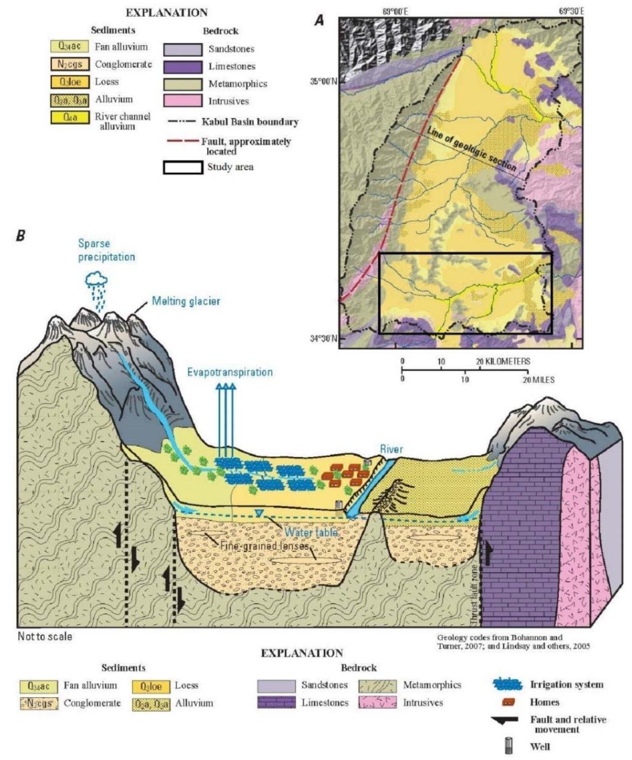
2.1. The Study Area Description
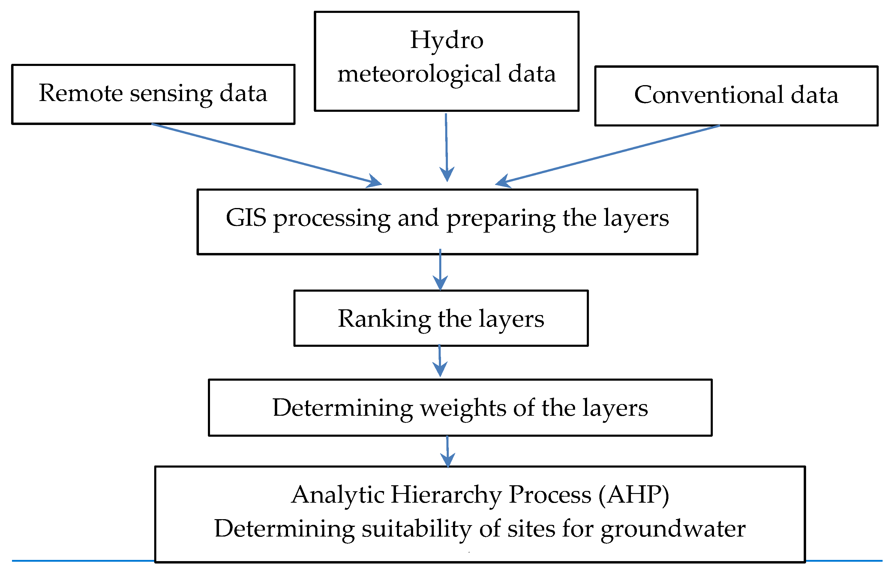
2.2. Overall Methodology
- Identifying criteria and preparing thematic layers,
- Ranking the thematic layers,
- Weighting of the criteria (layers),
- Analyzing the overlay,
- Generating the suitability map
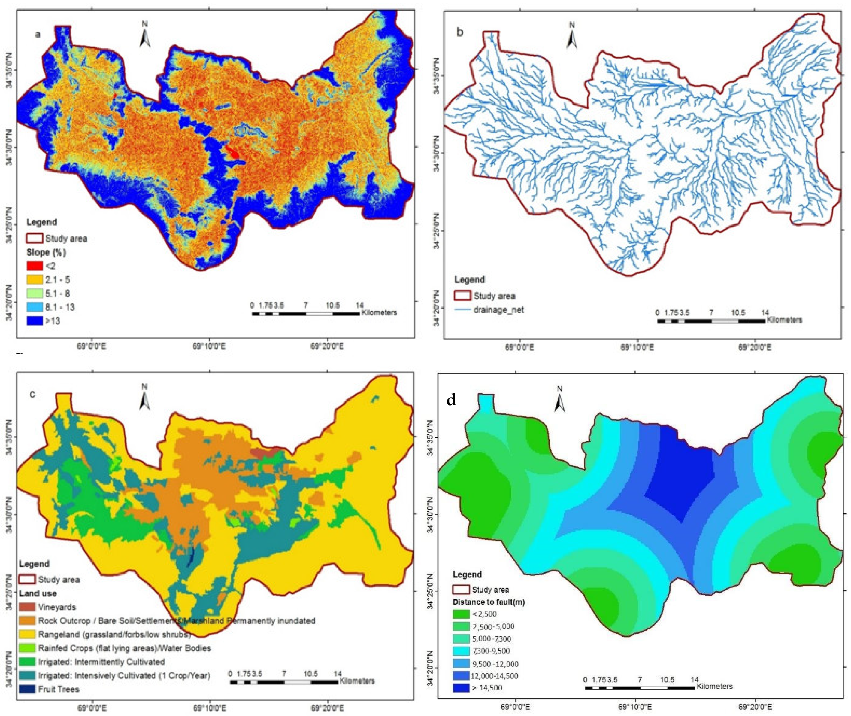
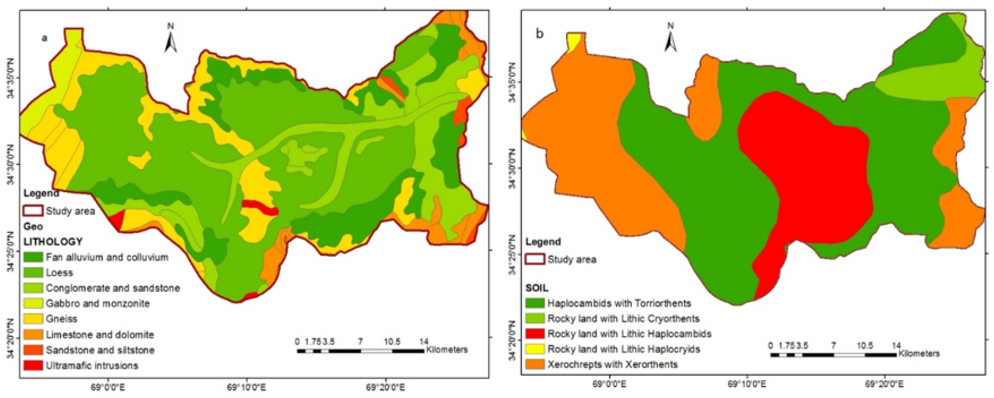
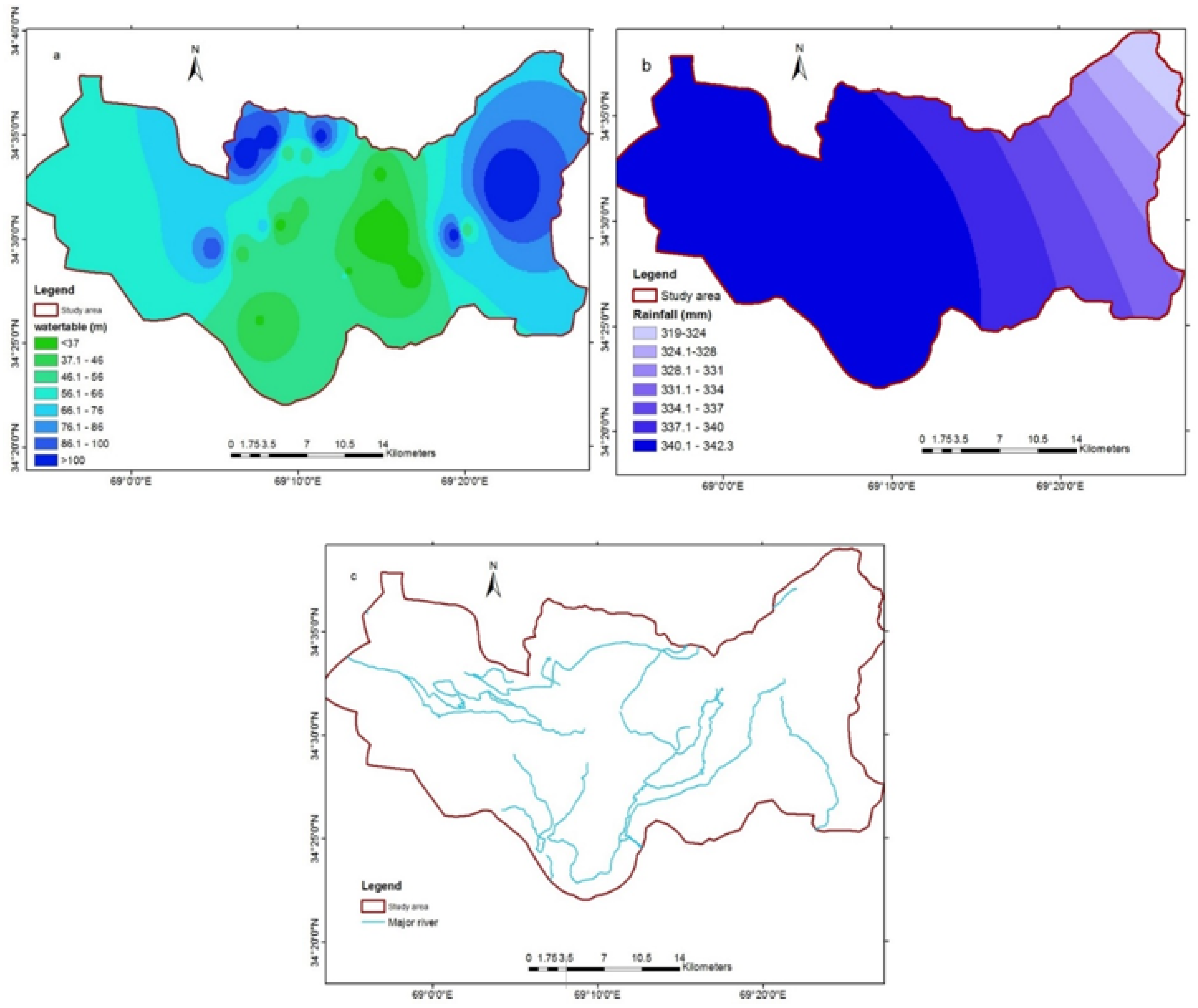
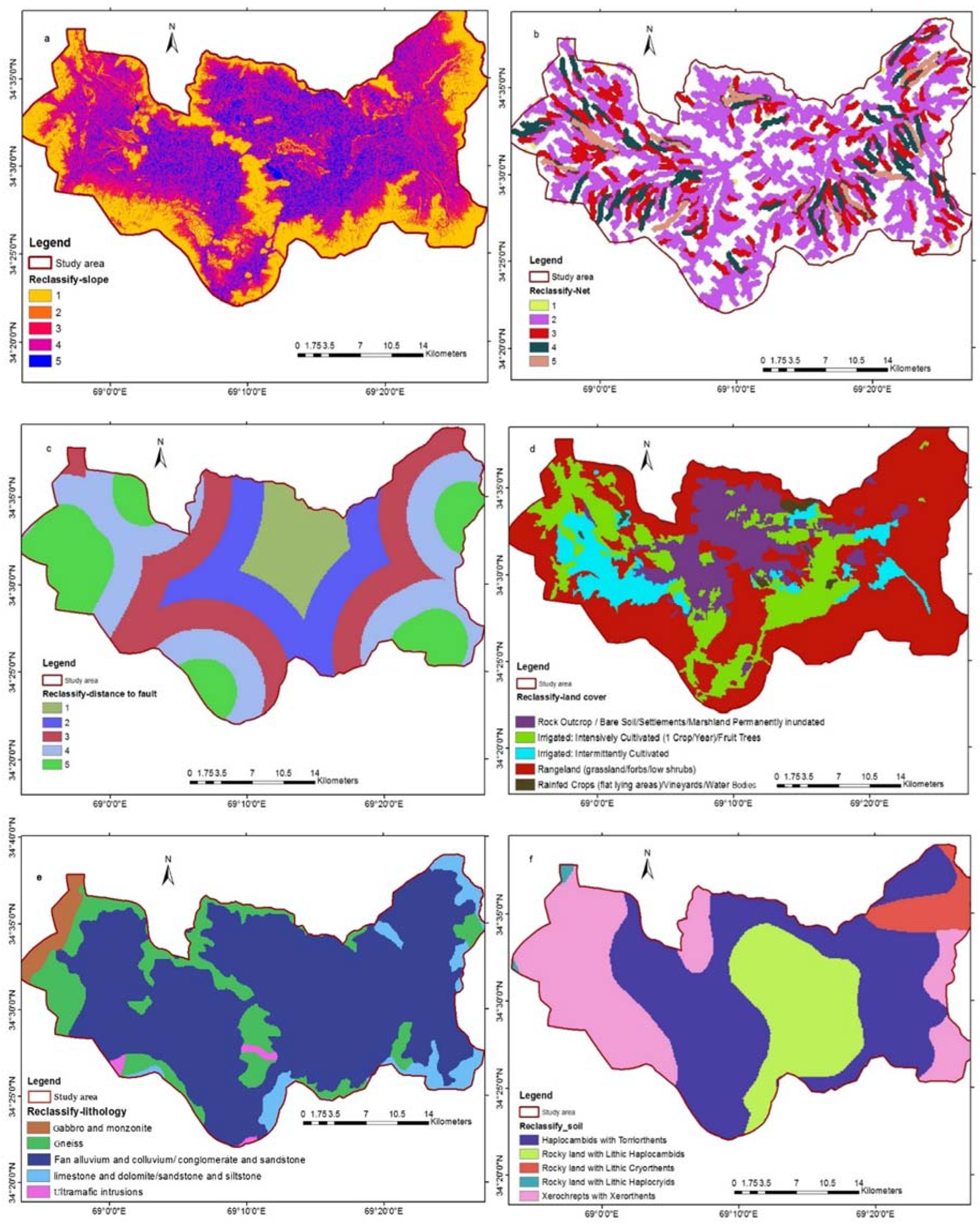
2.3. Identify Criteria and Preparation of Thematic Layers
2.3.1. Remote Sensing Data
2.3.2. Conventional Data
2.3.3. Meteorological Data
2.4. Ranking the Thematic Layers
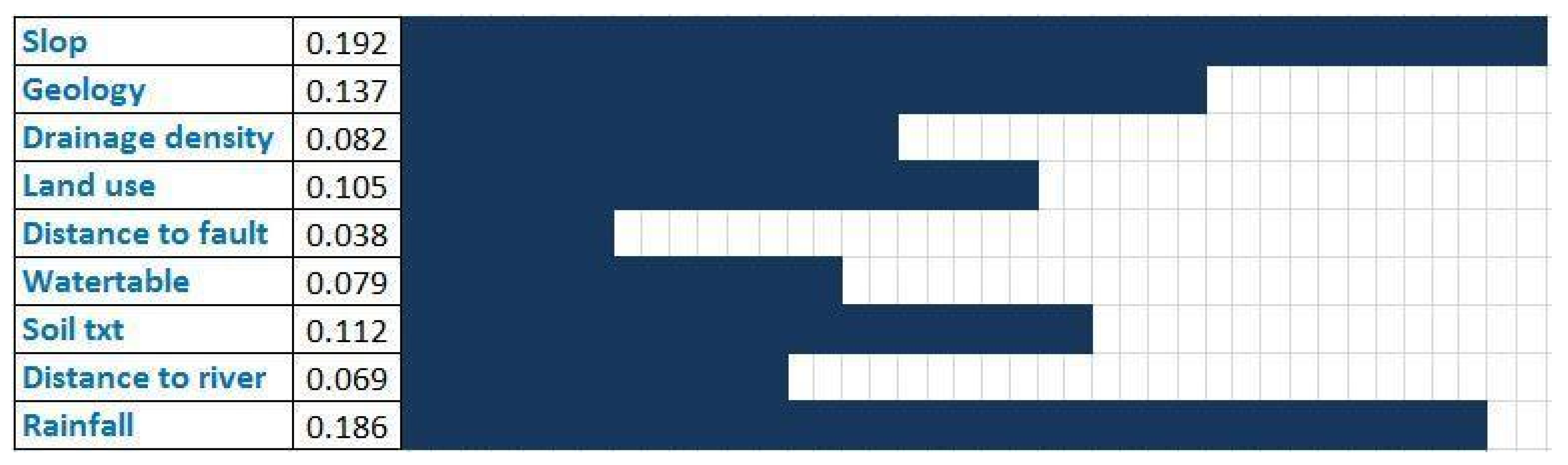
2.5. Determining Weights for the Criteria (Layers)
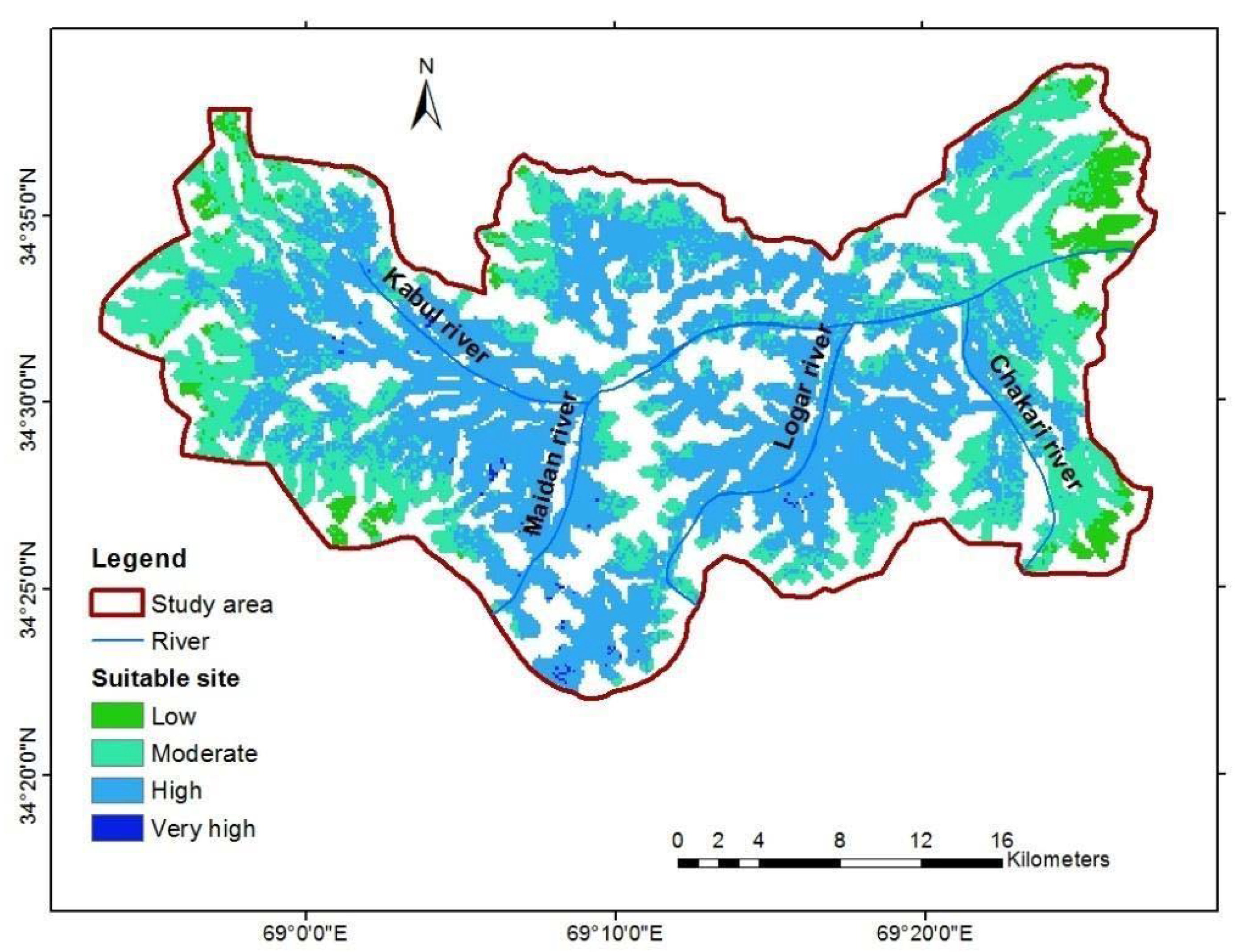
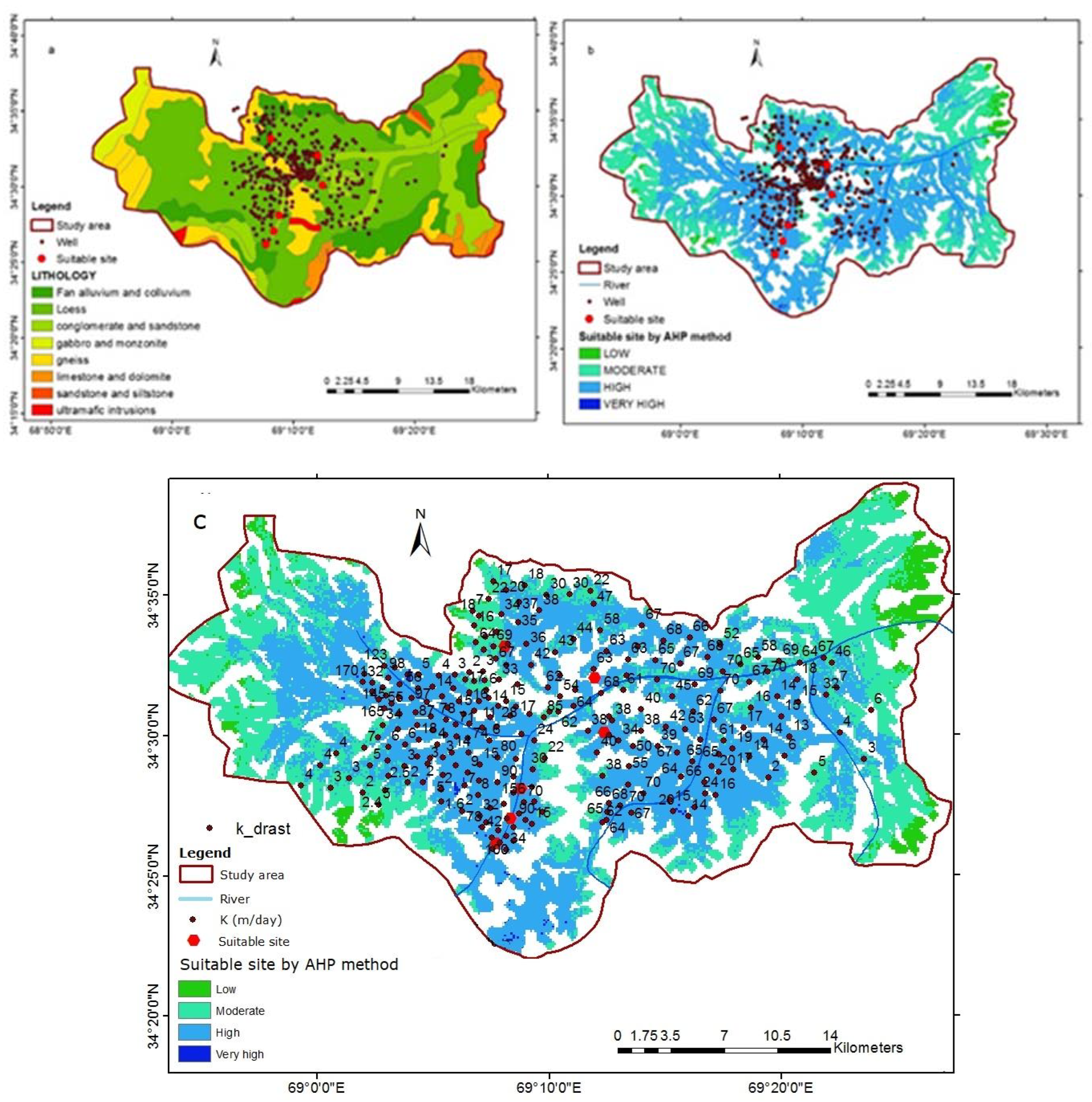
3. Results
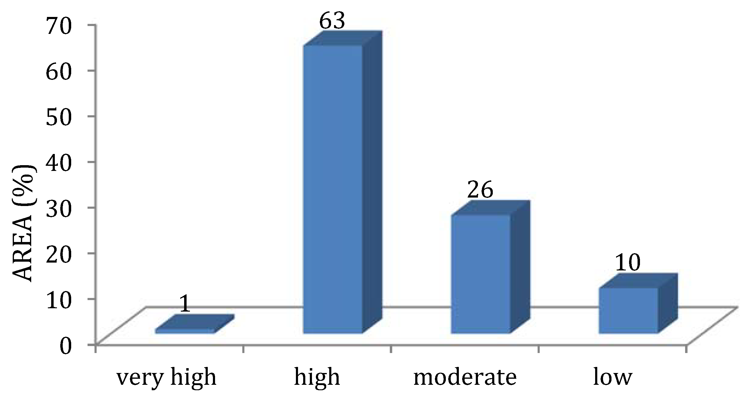
Map of Groundwater Recharge Potential
4. Discussion
4.1. Delineation of Groundwater Potential Recharge Zones
4.2. Validation
5. Conclusions
Author Contributions
Funding
Acknowledgments
Conflicts of Interest
References
- Akbari, M.A.; Tahir, M.; Litke, D.W.; Chornack, M.P. Ground-Water Levels in the Kabul Basin, Afghanistan, 2004–2007; The U.S. Geological Survey: Kabul, Afghanistan, 2007.
- Farahmand, A.; Hussaini, M.S.; Zaryab, A.; Aqili, S.W. Evaluation of Hydrogeoethics approach for sustainable management of groundwater resources in the upper Kabul sub-basin, Afghanistan. Sustain. Water Resour. Manag. 2021, 7, 1–7. [Google Scholar]
- Jawadi, H.A.; Sagin, J.; Snow, D.D. A detailed assessment of groundwater quality in the Kabul Basin, Afghanistan, and suitability for future development. Water 2020, 12, 2890. [Google Scholar] [CrossRef]
- Jawadi, H.A.; Iqbal, M.W.; Naseri, M.; Farahmand, A.; Azizi, A.H.; Eqrar, M.N. Nitrate contamination in groundwater of Kabul Province, Afghanistan: Reasons behind and conceptual management framework discourse. J. Mt. Sci. 2022, 19, 1274–1291. [Google Scholar] [CrossRef]
- Noori, A.R.; Singh, S.K. Status of groundwater resource potential and its quality at Kabul, Afghanistan: A review. Environ. Earth Sci. 2021, 80, 654. [Google Scholar] [CrossRef]
- Noori, A.R.; Singh, S.K. Spatial and temporal trend analysis of groundwater levels and regional groundwater drought assessment of Kabul, Afghanistan. Environ. Earth Sci. 2021, 80, 698. [Google Scholar] [CrossRef]
- Mack, T.J.; Chornack, M.P.; Taher, M.R. Groundwater-level trends and implications for sustainable water use in the Kabul Basin, Afghanistan. Environ. Syst. Decis. 2013, 33, 457–467. [Google Scholar] [CrossRef] [Green Version]
- Taher, M.R.; Chornack, M.P.; Mack, T.J. Groundwater levels in the Kabul Basin, Afghanistan, U.S. Geological Survey Open-File Report 2004–2013; The U.S. Geological Survey: Kabul, Afghanistan, 2013; pp. 1–51.
- Zaryab, A.; Noori, A.R.; Wegerich, K.; Klove, B. Assessment of water quality and quantity trends in Kabul aquifers with an outline for future drinking supplies. Cent. Asian J. Water Res. 2017, 3, 3–11. [Google Scholar]
- Zaryab, A.; Nassery, H.R.; Alijani, F. The effects of urbanization on the groundwater system of the Kabul shallow aquifers, Afghanistan. Hydrogeol. J. 2021, 30, 429–443. [Google Scholar] [CrossRef]
- Zaryab, A.; Nassery, H.R.; Alijani, F. Identification sources of groundwater salinity and major hydrogeochemical processes in the Lower Kabul Basin aquifer, Afghanistan. Environ. Sci. Processes Impacts 2021, 23, 1589–1599. [Google Scholar] [CrossRef] [PubMed]
- Zaryab, A.; Nassery, H.R.; Knoeller, K.; Alijani, F.; Minet, E. Determining nitrate pollution sources in the Kabul Plain aquifer (Afghanistan) using stable isotopes and Bayesian stable isotope mixing model. Sci. Total Environ. 2022, 823, 153749. [Google Scholar] [CrossRef]
- Escalante, E.F.; Gil, R.C.; Fraile, M.Á.S.M.; Serrano, F.S. Economic assessment of opportunities for Managed Aquifer recharge techniques in Spain using an advanced geographic information system (GIS). Water 2014, 6, 2021–2040. [Google Scholar] [CrossRef] [Green Version]
- Fuentes, C.; Chávez, C.; Quevedo, A.; Trejo-Alonso, J.; Fuentes, S. Modeling of artificial groundwater recharge by wells: A model stratified porous medium. Mathematics 2020, 8, 1764. [Google Scholar] [CrossRef]
- Horriche, F.J.; Benabdallah, S. Assessing aquifer water level and salinity for a managed artificial recharge site using reclaimed water. Water 2020, 12, 2–11. [Google Scholar]
- Hussain, F.; Hussain, R.; Wu, R.S.; Abbas, T. Rainwater harvesting potential and utilization for artificial recharge of groundwater using recharge wells. Processes 2019, 7, 623. [Google Scholar] [CrossRef] [Green Version]
- Meaški, H.; Biondić, R.; Loborec, J.; Oskoruš, D. The possibility of managed aquifer recharge (Mar) for normal functioning of the public water-supply of Zagreb, Croatia. Water 2021, 13, 1562. [Google Scholar] [CrossRef]
- Salameh, E.; Abdallat, G.; van der Valk, M. Planning considerations of managed aquifer recharge (MAR) projects in Jordan. Water 2019, 11, 182. [Google Scholar] [CrossRef] [Green Version]
- Chowdhury, A.; Jha, M.K.; Chowdary, V.M. Delineation of groundwater recharge zones and identification of artificial recharge sites in West Medinipur district, West Bengal, using RS, GIS and MCDM techniques. Environ. Earth Sci. 2021, 59, 1209–1222. [Google Scholar] [CrossRef]
- Todd, D.K.; Mays, L.W. Groundwater Hydrology, 3rd ed.; Wiley: Hoboken, NJ, USA, 2004; pp. 547–589. [Google Scholar]
- Jung, H.S.; Lee, S. Remote sensing and geoscience information systems applied to groundwater research. Remote Sens. 2021, 13, 2086. [Google Scholar] [CrossRef]
- Wehbe, Y.; Temimi, M. A remote sensing-based assessment of water resources in the arabian peninsula. Remote Sens. 2021, 13, 247. [Google Scholar] [CrossRef]
- Sagintayev, Z.; Sultan, M.; Khan, S.D.; Khan, S.A.; Mahmood, K.; Yan, E.; Milewski, A.; Marsala, P. A remote sensing contribution to hydrologic modelling in arid and inaccessible watersheds, Pishin Lora basin, Pakistan. Hydrol. Process. 2012, 26, 85–99. [Google Scholar] [CrossRef]
- Shakoor, A.; Khan, Z.M.; Farid, H.U.; Sultan, M.; Ahmad, I.; Ahmad, N.; Mahmood, M.H.; Ali, M.U. Delineation of regional groundwater vulnerability using DRASTIC model for agricultural application in Pakistan. Arab. J. Geosci. 2020, 13, 2–23. [Google Scholar] [CrossRef]
- Lentswe, G.B.; Molwalefhe, L. Delineation of potential groundwater recharge zones using analytic hierarchy process-guided GIS in the semi-arid Motloutse watershed, eastern Botswana. J. Hydrol. Reg. Stud. 2020, 28, 2–22. [Google Scholar] [CrossRef]
- Ozdemir, A. Using a binary logistic regression method and GIS for evaluating and mapping the groundwater spring potential in the Sultan Mountains (Aksehir, Turkey). J. Hydrol. 2011, 405, 123–136. [Google Scholar] [CrossRef]
- Golkarian, A.; Rahmati, O. Use of a maximum entropy model to identify the key factors that influence groundwater availability on the Gonabad Plain, Iran. Environ. Earth Sci. 2018, 77, 2–20. [Google Scholar] [CrossRef]
- Naghibi, S.A.; Pourghasemi, H.R.; Abbaspour, K. A comparison between ten advanced and soft computing models for groundwater qanat potential assessment in Iran. Theor. Appl. Climatol. 2018, 131, 3–4. [Google Scholar] [CrossRef]
- Leblanc, M.; Leduc, C.; Razack, M.; Lemoalle, J.; Dagorne, D.; Mofor, L. Applications of remote sensing and GIS for groundwater modelling of large semiarid areas: Example of the Lake Chad Basin, Africa. Int. Assoc. Hydrol. Sci. Publ. 2003, 278, 186–194. [Google Scholar]
- Tweed, S.O.; Leblanc, M.; Webb, J.A.; Lubczynski, M.W. Remote sensing and GIS for mapping groundwater recharge and discharge areas in salinity prone catchments, southeastern Australia. Hydrogeol. J. 2007, 15, 75–96. [Google Scholar] [CrossRef]
- Pittore, M.; Wieland, M.; Fleming, K. Perspectives on global dynamic exposure modeling for geo-risk assessment. Nat. Hazards 2017, 86, 7–30. [Google Scholar] [CrossRef]
- Ahirwar, S.; Malik, M.S.; Ahirwar, R.; Shukla, J.P. Application of Remote Sensing and GIS for Groundwater Recharge Potential Zone Mapping in Upper Betwa Watershed. J. Geol. Soc. India 2020, 95, 308–314. [Google Scholar] [CrossRef]
- Allafta, H.; Opp, C.; Patra, S. Identification of groundwater potential zones using remote sensing and GIS techniques: A case study of the shatt Al-Arab Basin. Remote Sens. 2021, 13, 112. [Google Scholar] [CrossRef]
- Gaber, A.; Mohamed, A.K.; Elgalladi, A.; Abdelkareem, M.; Beshr, A.M.; Koch, M. Mapping the groundwater potentiality of West Qena area, Egypt, using integrated remote sensing and hydro-geophysical techniques. Remote Sens. 2020, 12, 1559. [Google Scholar] [CrossRef]
- Lee, S.; Hyun, Y.; Lee, S.; Lee, M.J. Groundwater potential mapping using remote sensing and GIS-based machine learning techniques. Remote Sens. 2020, 12, 1200. [Google Scholar] [CrossRef] [Green Version]
- Qadir, J.; Bhat, M.S.; Alam, A.; Rashid, I. Mapping groundwater potential zones using remote sensing and GIS approach in Jammu Himalaya, Jammu and Kashmir. Geo. J. 2020, 85, 487–504. [Google Scholar] [CrossRef]
- Xu, G.; Su, X.; Zhang, Y.; You, B. Identifying potential sites for artificial recharge in the plain area of the daqing river catchment using gis-based multi-criteria analysis. Sustainability 2021, 13, 3978. [Google Scholar] [CrossRef]
- Thapa, R.; Gupta, S.; Guin, S.; Kaur, H. Assessment of groundwater potential zones using multi-influencing factor (MIF) and GIS: A case study from Birbhum district, West Bengal. Appl. Water Sci. 2017, 7, 4117–4131. [Google Scholar] [CrossRef]
- Valis, D.; Hsilova, K.; Forbelska, M. Modeling water distribution network failures and deterioration. In Proceedings of the IEEE International Conference on Industrial and Engineering and Engineering Management, Singapore, 10–13 December 2017; pp. 924–928. [Google Scholar] [CrossRef]
- Gdoura, K.; Anane, M.; Jellali, S. Geospatial and AHP-multicriteria analyses to locate and rank suitable sites for groundwater recharge with reclaimed water. Resour. Conserv. Recycl. 2015, 104, 19–30. [Google Scholar] [CrossRef]
- Kadhem, G.M.; Zubari, W.K. Identifying Optimal Locations for Artificial Groundwater Recharge by Rainfall in the Kingdom of Bahrain. Earth Syst. Environ. 2020, 4, 551–566. [Google Scholar] [CrossRef]
- Ahmadi, H.; Kaya, O.A.; Babadagi, E.; Savas, T.; Pekkan, E. GIS-Based Groundwater Potentiality Mapping Using AHP and FR Models in Central Antalya, Turkey. Environ. Sci. Proc. 2020, 5, 11. [Google Scholar]
- Rajasekhar, M.; Sudarsana Raju, G.; Siddi Raju, R. Assessment of groundwater potential zones in parts of the semi-arid region of Anantapur District, Andhra Pradesh, India using GIS and AHP approach. Modeling Earth Syst. Environ. 2019, 5, 1303–1317. [Google Scholar] [CrossRef]
- Yıldırım, Ü. Identification of Groundwater Potential Zones Using GIS and Multi-Criteria Decision-Making Techniques: A Case Study Upper Coruh River Basin (NE Turkey). ISPRS Int. J. Geo-Inf. 2021, 10, 396. [Google Scholar] [CrossRef]
- Anane, M.; Kallali, H.; Jellali, S.; Ouessar, M. Ranking suitable sites for Soil Aquifer Treatment in Jerba Island (Tunisia) using remote sensing, GIS and AHP-multicriteria decision analysis. Int. J. Water 2008, 4, 121–135. [Google Scholar] [CrossRef]
- Machiwa, J.F. African Journal of Aquatic Science Nature of suspended particulate matter and concentrations of heavy metals in sediment in the southern part of Lake Victoria, East Africa Nature of suspended particulate matter and concentrations of heavy. Afr. J. Aquat. Sci. 2010, 35, 95–101. [Google Scholar] [CrossRef]
- MAIL. Afghanistan Land use Map. National Water Affair Regulation Authority of Afghanistan; FAO: Kabul, Afghanistan, 2020. [Google Scholar]
- USGS. Geologic Faults of Afghanistan; The U.S. Geological Survey: Kabul, Afghanistan, 2006.
- Peters, S.G.; King, T.V.V.; Mack, T.J.; Chornack, M.P. Summaries of Important Areas for Mineral Investment and Production Opportunities of Nonfuel Minerals in Afghanistan; The U.S. Geological Survey: Kabul, Afghanistan, 2011. Available online: https://afghanistan.cr.usgs.gov/ (accessed on 8 February 2022).
- Lindsay, C.R.; Snee, L.W.; Bohannon, R.R. Geologic Map of Quadrangle 3568, Polekhomri (503) and Charikar (504) Quadrangles, Afghanistan; The U.S. Geological Survey: Kabul, Afghanistan, 2005. Available online: https://www.usgs.gov/publications/maps-quadrangle-3568-polekhomri-503-and-charikar-504-quadrangles-afghanistan (accessed on 12 February 2022).
- Bohannon, R.G.; Turner, K.J. Geologic Map of Quadrangle 3468, Chak Wardak-Syahgerd (509) and Kabul (510) Quadrangles, Afghanistan; The U.S. Geological Survey: Kabul, Afghanistan, 2007.
- Mack, T.J.; Akbari, M.A.; Ashoor, M.H.; Chornack, M.P.; Coplen, T.B.; Emerson, D.G.; Hubbard, B.E.; Litke, D.W.; Michel, R.L.; Plummer, L.N.; et al. Conceptual Model of Water Resources in the Kabul Basin, Afghanistan; The U.S. Geological Survey: Kabul, Afghanistan, 2009; 168, p. 255.
- Böckh, E.G. Report on the Groundwater Resources of the City of Kabul-Report for Bundesanstalt fÜr Geowissenschaften und rohstoffe. 1971; unpublished. [Google Scholar]
- USDA. Afghanistan-Soil Map. United States Department of Agriculture; 2001. Available online: https://www.nrcs.usda.gov/ (accessed on 25 February 2022).
- AGEC. Final Well Construction Report for World Bank HQ Building Water Well. 2017. Available online: http://www.afghanite.net/ (accessed on 26 February 2022).
- Genxu, W.; Lingyuan, Y.; Lin, C.; Kubota, J. Impacts of land use changes on groundwater resources in the Heihe River Basin. J. Geogr. Sci. 2005, 15, 405–414. [Google Scholar] [CrossRef]
- Saravanan, S.; Jennifer, J.J.; Singh, L.; Thiyagarajan, S.; Sankaralingam, S. Impact of land-use change on soil erosion in the Coonoor Watershed, Nilgiris Mountain Range, Tamil Nadu, India. Arab. J. Geosci. 2021, 14, 1–15. [Google Scholar] [CrossRef]
- Sims, D.W.; Waiting, D.J.; Morris, A.P.; Franklin, N.M.; Schultz, A.L. Structural framework of the Edwards Aquifer recharge zone in south-central Texas. GSA Bull. 2004, 116, 407–418. [Google Scholar]
- Agarwal, R.; Garg, P.K. Remote Sensing and GIS Based Groundwater Potential & Recharge Zones Mapping Using Multi-Criteria Decision-Making Technique. Water Resour. Manag. 2015, 30, 243–260. [Google Scholar]
- Mogaji, K.A.; Omosuyi, G.O.; Adelusi, A.O. Application of GIS-Based Evidential Belief Function Model to Regional Groundwater Recharge Potential Zones Mapping in Hardrock Geologic Terrain. Environ. Monit. Assess. 2016, 3, 93–123. [Google Scholar]
- Abijith, D.; Saravanan, S.; Singh, L.; Jacinth, J.; Saranya, T.; Parthasarathy, K.S.; Jennifer, J.J.; Saranya, T.; Parthasarathy, K.S. GIS-based multi-criteria analysis for identification of potential groundwater recharge zones—A case study from Ponnaniyaru watershed, Tamil Nadu, India. HydroResearch 2020, 3, 1–14. [Google Scholar] [CrossRef]
- CGWB. Manual on Artificial Recharge of Groundwater; Ministry of Water Resources of India: Faridabad, India, 2007.
- Saaty, T.L. Analytic Hierarchy Process; Wiley Stats Ref: Statistics Reference online; John & Wiley & Sons: Hoboken, NJ, USA, 2014; Volume 1, p. 11. [Google Scholar]
- Selvam, S.; Dar, F.A.; Magesh, N.S.; Singaraja, C.; Venkatramanan, S.; Chung, S.Y. Application of remote sensing and GIS for delineating groundwater recharge potential zones of Kovilpatti Municipality, Tamil Nadu using IF technique. Earth Sci. Inform. 2016, 9, 137–150. [Google Scholar] [CrossRef]
- Magesh, N.S.; Chandrasekar, N.; Soundranayagam, J.P. Delineation of groundwater potential zones in Theni district, Tamil Nadu, using remote sensing, GIS and MIF techniques. Geosci. Front. 2012, 3, 189–196. [Google Scholar] [CrossRef] [Green Version]
- The United Nations World Water Development Report. Groundwater: Making the invisible visible. 2022. Available online: https://www.unwater.org/publications/un-world-water-development-report-2022/ (accessed on 12 February 2022).


| Parameters | Range | Rank |
|---|---|---|
| Slope (Degree) | 0–2 | 5 |
| 2.1–5 | 4 | |
| 5.1–8 | 3 | |
| 8.1–13 | 2 | |
| 13.1–77 | 1 | |
| Lithology | Gneiss | 1 |
| ultramafic intrusions | 2 | |
| gabbro and monzonite | 3 | |
| sandstone and siltstone/carbonates | 4 | |
| Fan alluvium and colluvium/loess/conglomerate and fractured sandstone | 5 | |
| Drainage density | 0–0.17 | 1 |
| 0.17–0.30 | 2 | |
| 0.30–0.46 | 3 | |
| 0.46–0.67 | 4 | |
| >0.67 | 5 | |
| Land-use | Rock Outcrop/ Bare Soil/Settlements/Marshland Permanently inundated | 1 |
| Fruit Trees/Irrigated: Intensively Cultivated (1 crop/Year) | 2 | |
| Irrigated: Intermittently Cultivated/Vineyards | 3 | |
| Rangeland (grassland/forbs/low shrubs) | 4 | |
| Rain fed Crops (flat lying areas)/Water bodies | 5 | |
| ground water table (m) | >60 | 2 |
| 30–60 | 4 | |
| 15–30 | 5 | |
| <15 | 1 | |
| Rainfall (mm) | 319.25–323.86 | 1 |
| 323.861–328.47 | 2 | |
| 328.4701–333.07 | 3 | |
| 333.078–337.6 | 4 | |
| 337.68–342.3 | 5 | |
| Distance to river (m) | 0–50 | 3 |
| 50–300 | 5 | |
| 300–1000 | 4 | |
| 1000–5000 | 2 | |
| >5000 | 1 | |
| Distance to fault (m) | 0–3500 | 3 |
| 3500–6600 | 5 | |
| 6600–9800 | 4 | |
| 9800–13,500 | 2 | |
| >13,500 | 1 | |
| Soil | Haplocambids with Torriorthents | 5 |
| Rocky land with Lithic Haplocambids | 4 | |
| Rocky lands with Lithic Cryorthents | 3 | |
| Xerorthents and Xerochrepts | 2 | |
| Rocky land with Lithic Haplocryids | 1 |
| Intensity of Importance | Interpretation |
|---|---|
| 1 | Equal importance |
| 3 | Moderate importance |
| 5 | Essential |
| 7 | Very strong importance |
| 9 | Extreme importance |
| 2,4,6,8 | Intermediate value between adjacent scale values |
| Parameter | Slope | Geology | Drainage Density | Land Use | Distance to Fault | Water Table | Soil Texture | Distance to River | Rainfall |
|---|---|---|---|---|---|---|---|---|---|
| Slope | 1 | 1.09 | 1.5 | 3 | 5 | 4.5 | 2 | 4 | 1.63 |
| Geology | 0.91 | 1 | 2 | 3 | 2.5 | 1.5 | 2 | 1.02 | 2.16 |
| Drainage Density | 0.66 | 0.5 | 1 | 1.5 | 2.5 | 1.5 | 2.5 | 2 | 3.06 |
| Land use | 0.33 | 0.33 | 0.66 | 1 | 3 | 5 | 1.5 | 2 | 2.58 |
| Distance to fault | 0.2 | 0.4 | 0.4 | 0.33 | 1 | 1.6 | 1.5 | 2.02 | 6.96 |
| Water table | 0.22 | 0.66 | 0.66 | 0.2 | 0.62 | 1 | 1 | 1.01 | 1.07 |
| Soil texture | 0.5 | 0.5 | 0.4 | 0.66 | 0.66 | 1 | 1 | 3 | 1.26 |
| Distance to river | 0.25 | 0.98 | 0.5 | 0.5 | 0.49 | 0.99 | 0.33 | 1 | 1.24 |
| Rainfall | 0.61 | 0.46 | 0.32 | 0.38 | 0.14 | 0.93 | 0.79 | 0.80 | 1 |
| CI | 0.09 |
Publisher’s Note: MDPI stays neutral with regard to jurisdictional claims in published maps and institutional affiliations. |
© 2022 by the authors. Licensee MDPI, Basel, Switzerland. This article is an open access article distributed under the terms and conditions of the Creative Commons Attribution (CC BY) license (https://creativecommons.org/licenses/by/4.0/).
Share and Cite
Mahdawi, Q.; Sagin, J.; Absametov, M.; Zaryab, A. Water Recharges Suitability in Kabul Aquifer System within the Upper Indus Basin. Water 2022, 14, 2390. https://doi.org/10.3390/w14152390
Mahdawi Q, Sagin J, Absametov M, Zaryab A. Water Recharges Suitability in Kabul Aquifer System within the Upper Indus Basin. Water. 2022; 14(15):2390. https://doi.org/10.3390/w14152390
Chicago/Turabian StyleMahdawi, Qasim, Jay Sagin, Malis Absametov, and Abdulhalim Zaryab. 2022. "Water Recharges Suitability in Kabul Aquifer System within the Upper Indus Basin" Water 14, no. 15: 2390. https://doi.org/10.3390/w14152390
APA StyleMahdawi, Q., Sagin, J., Absametov, M., & Zaryab, A. (2022). Water Recharges Suitability in Kabul Aquifer System within the Upper Indus Basin. Water, 14(15), 2390. https://doi.org/10.3390/w14152390