
Flood Disaster Monitoring and Emergency Assessment Based on Multi-Source Remote Sensing Observations


Abstract
:1. Introduction
2. Study Area and Data
2.1. Study Area
2.2. Method
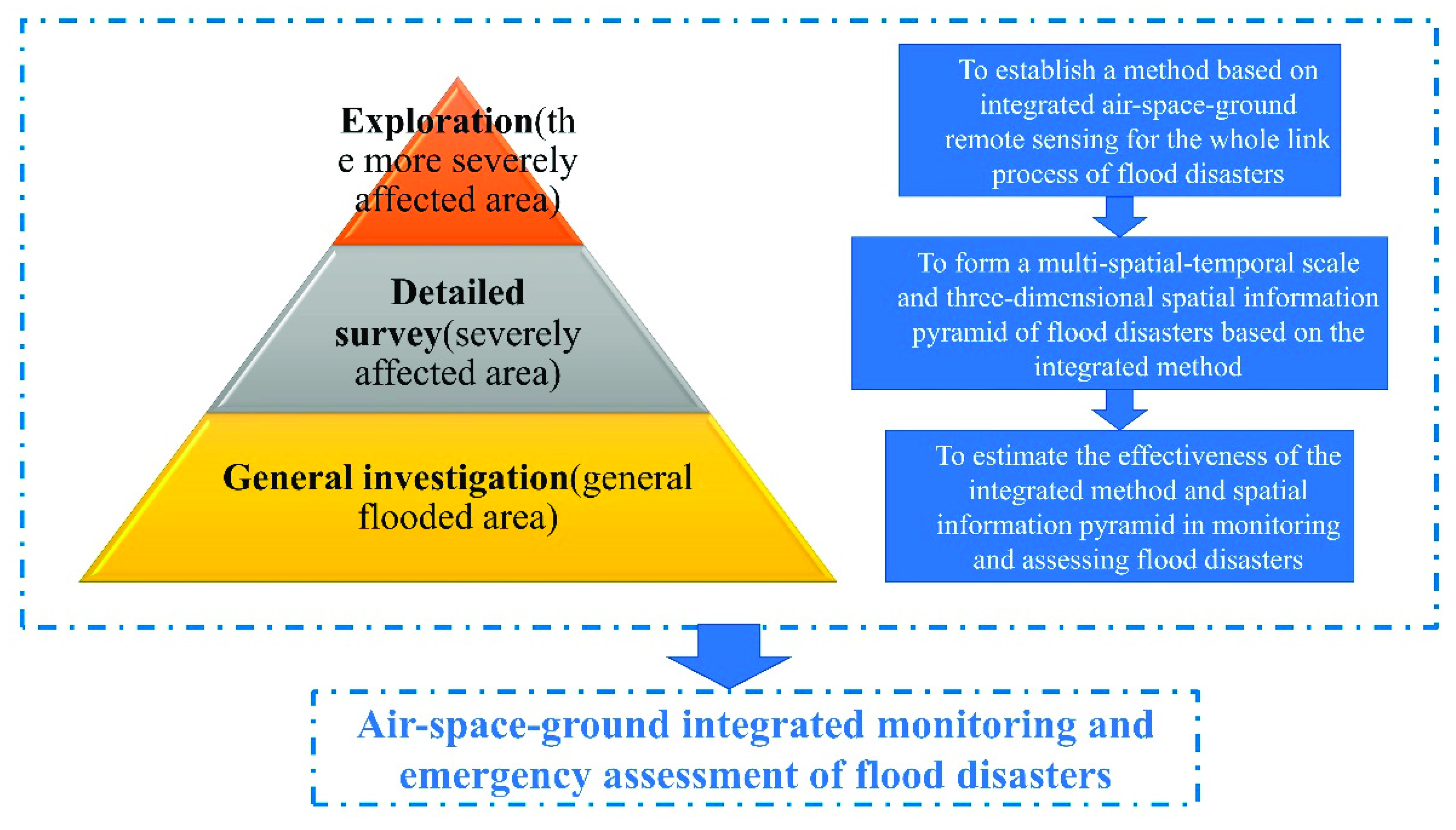
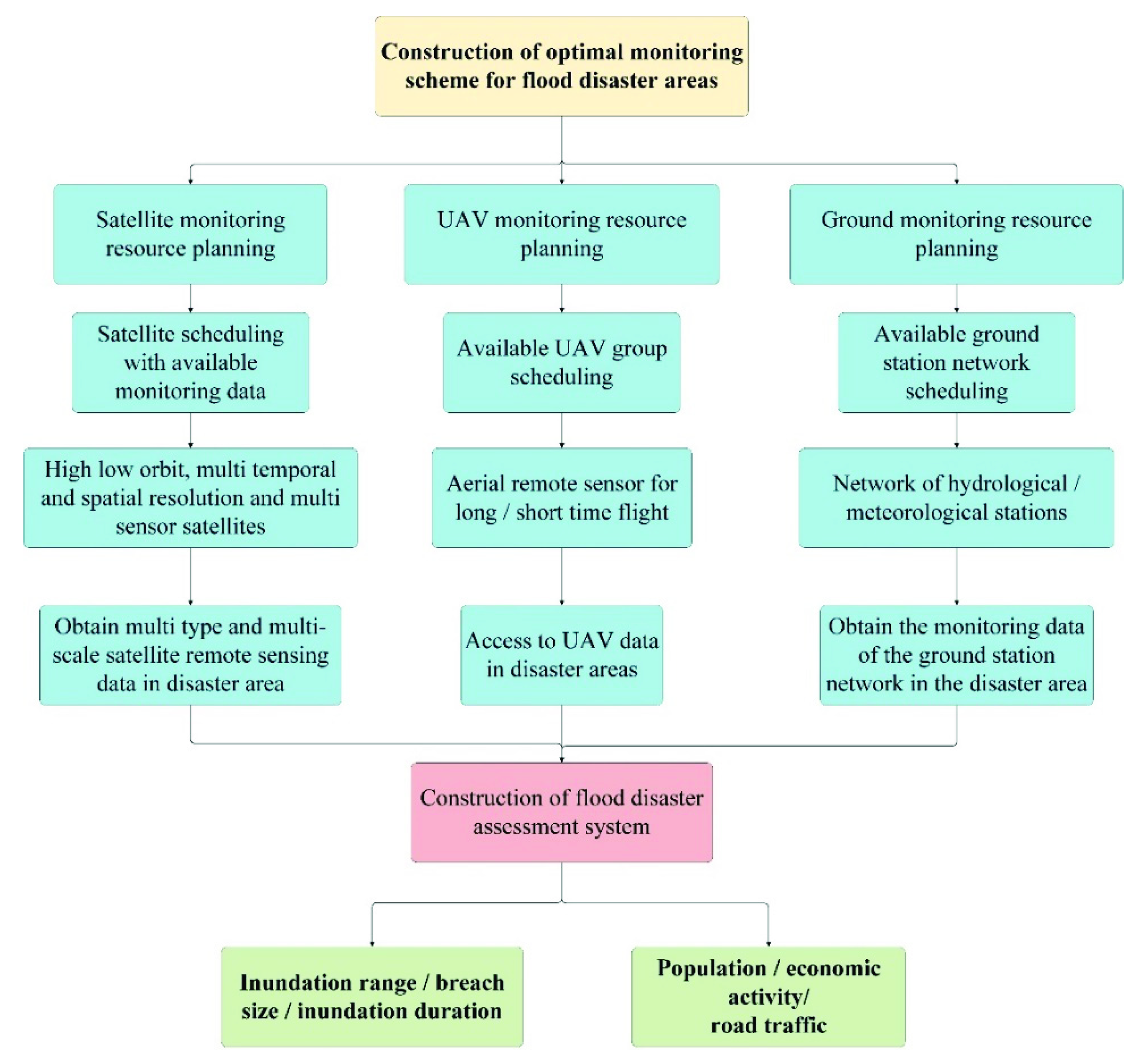
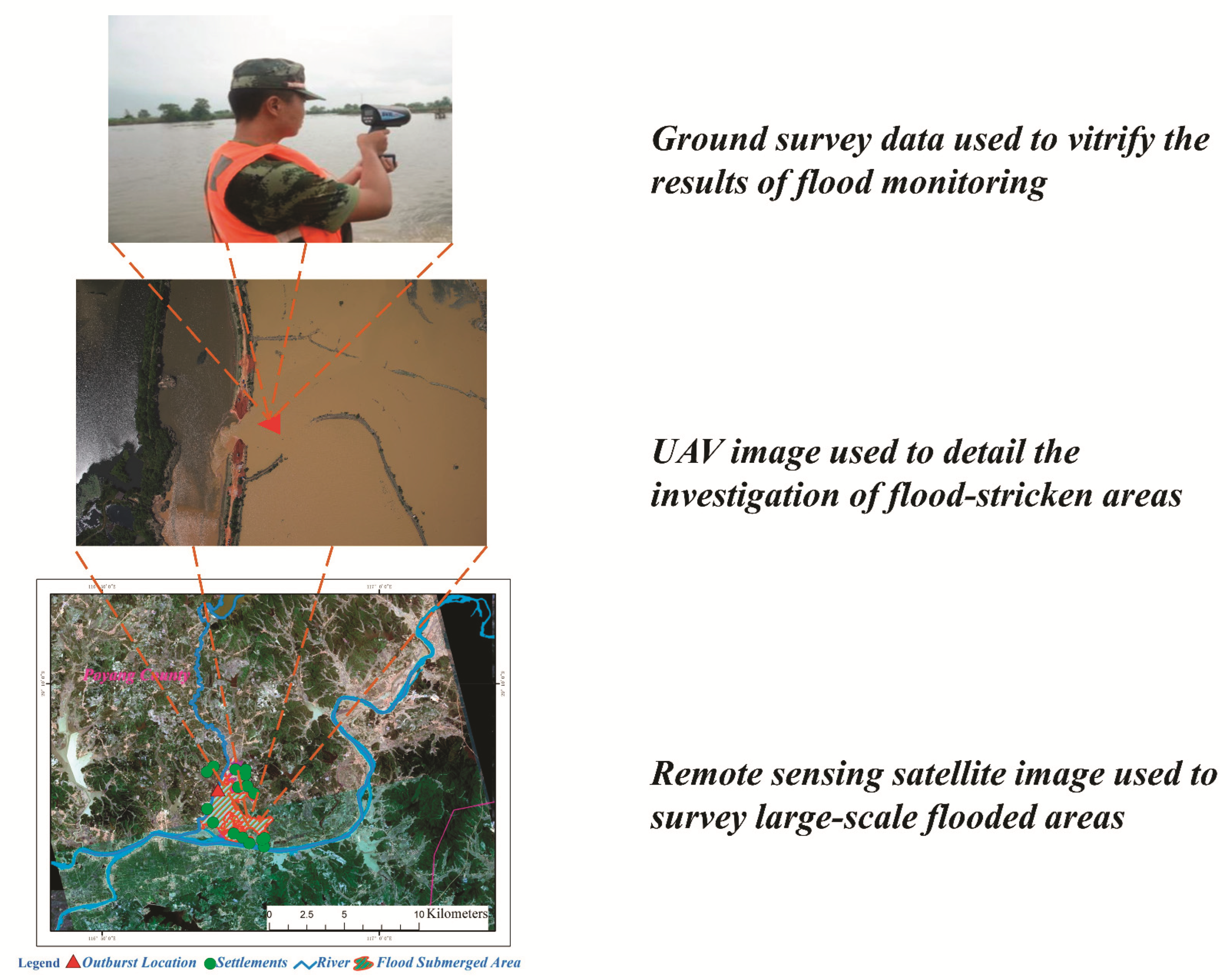
- Satellite remote sensing data, such as high-resolution optical images, were employed to obtain a global panorama of a region on a large scale, highlighting these problematic flood areas and realizing the macro description of the general survey level of the affected cultivated land and villages and towns. That is to say, after a flood disaster occurs, according to the specific conditions of the disaster, analyze and form the optimal joint scheduling and collaborative planning observation acquisition scheme for the aerial observation resources, carry out the coverage analysis and observation planning tasks for the satellite resources in the disaster area, and form the satellite observation data and satellites in the disaster area by analyzing the available high-low orbit, multi-temporal and spatial resolution and multi-sensor satellite resources satellite to earth observation common data products and other acquisition programs. In this process, targeted analysis and focus will be carried out according to the characteristics of flood disasters and the distribution characteristics of key observation targets. This is called the general investigation on macro-scale.
- Detailed assessments can be performed through the development of UAV tilt photography data for elaborating high-resolution relief maps. UAV was used to carry out the detailed investigation of the local flood area and focus on the levee breaches, collapsed houses, roads and bridges and damaged lifeline engineering information. In the case that satellite and aerial remote sensing cannot effectively cover or disaster targets needed to focus on high-precision observation, focusing on the specific needs of on-site information such as emergency response, the detailed spatial information acquisition technology and methods for UAV monitoring of flood disasters were carried out. Combined with brief information on flood disaster mechanism, disaster location and disaster time, the delineation design of priority observation areas such as residential areas, important lifelines (roads), outburst location and severe disaster areas was carried out to form a fine monitoring space network, flight area and route design for UAV with plane and strip combination. It could effectively support the acquisition of monitoring disaster information in key areas and the assessment of disaster situations in severe disaster areas, and ensure the timeliness of large-scale emergency command, rescue and search and rescue operations. This was called the detailed survey on medium-scale. It could make up for the deficiency of satellite remote sensing technology due to the weather, terrain, spatial resolution, etc.
- Third, with the development of a ground mobile disaster real-time verification system or equipment, a village will be a real-time disaster reported to the local flood control command center. This was called the exploration on local small-scale. As a consequence, the ground means were mainly used to accurately mark the flood location and confirm the disaster loss.
2.3. Data Acquisition
3. Results
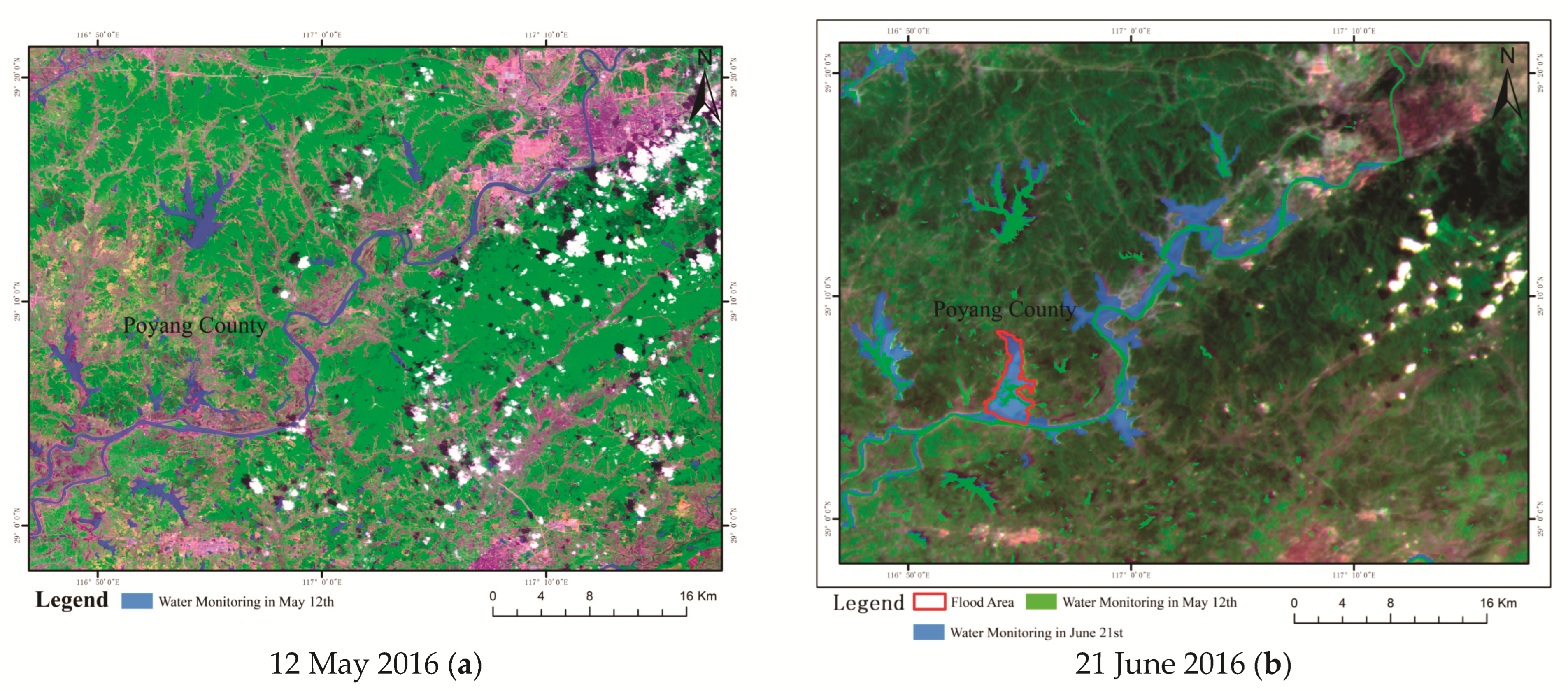
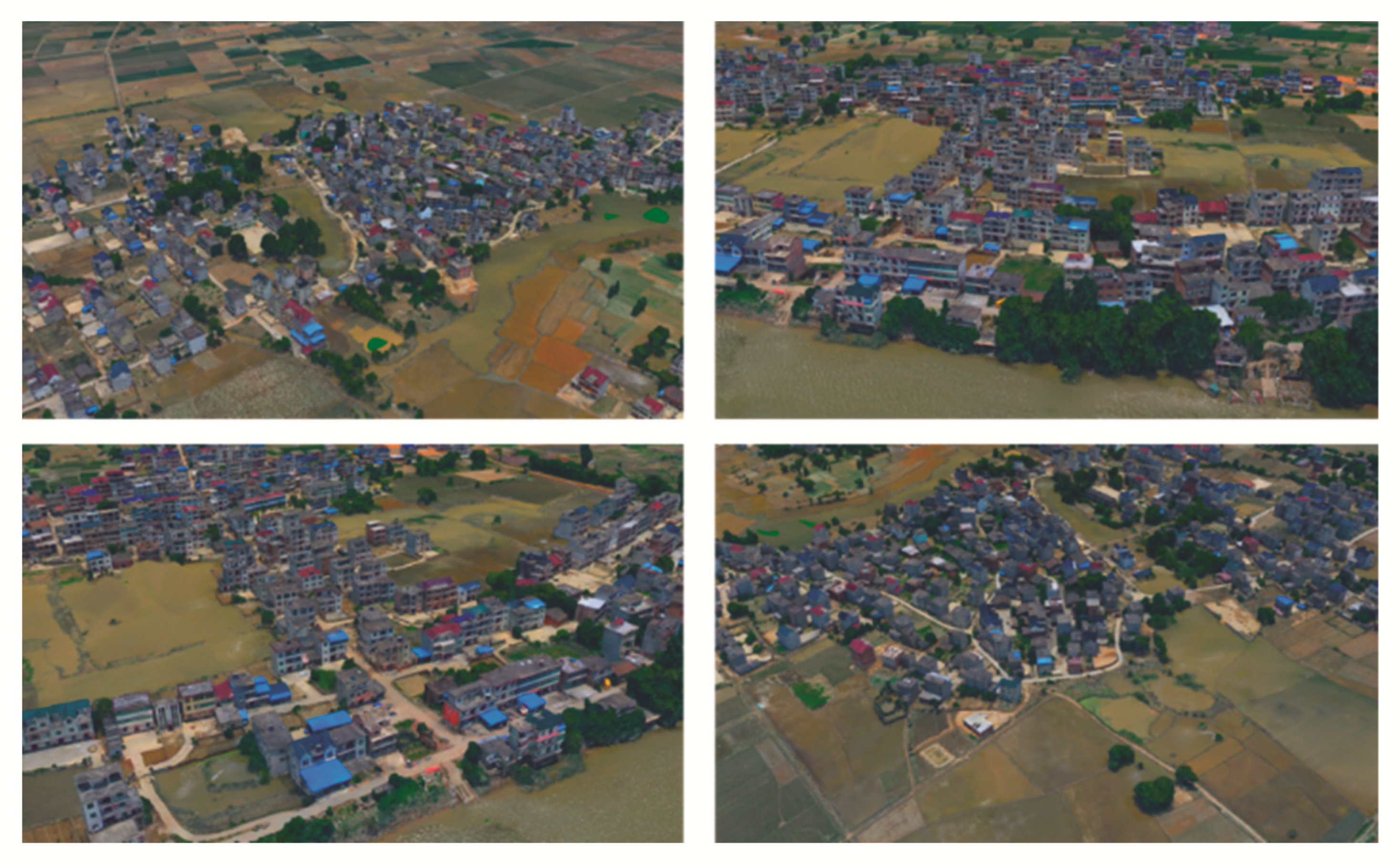
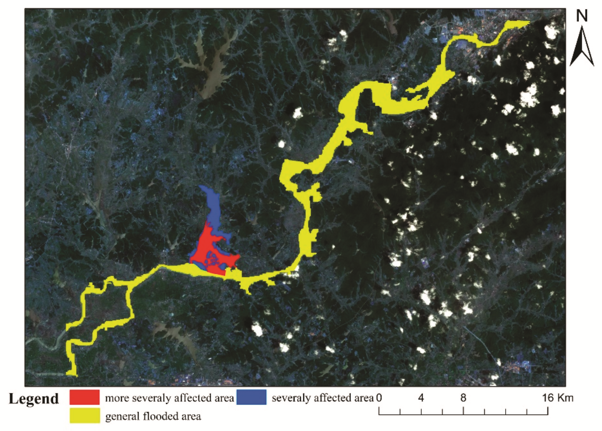
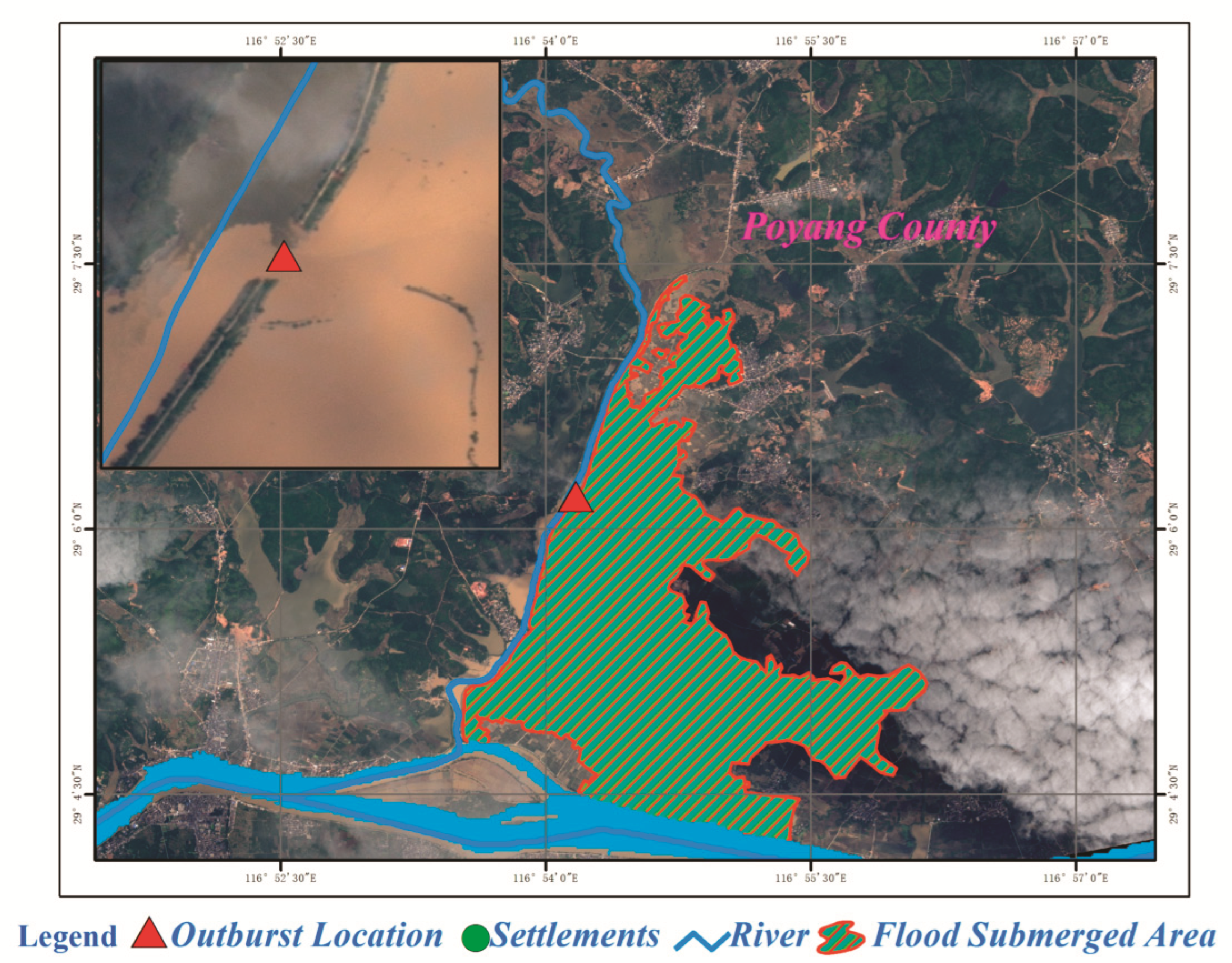
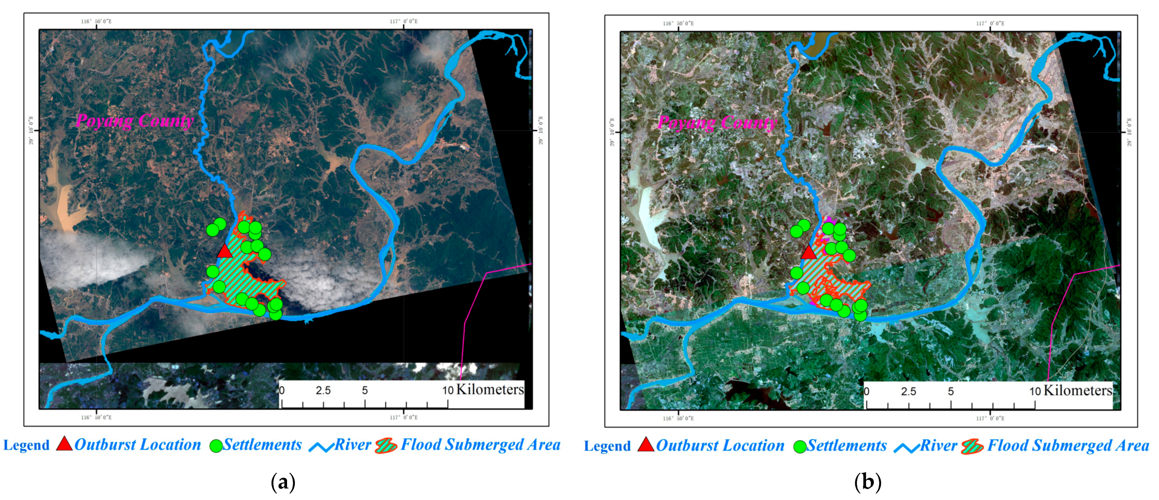
3.1. Gudu Town Flood Disaster Conditions
3.2. Integrated Air-Space-Ground Remote Sensing Monitoring of Flood Disaster
4. Discussion
5. Conclusions
Author Contributions
Funding
Institutional Review Board Statement
Informed Consent Statement
Data Availability Statement
Acknowledgments
Conflicts of Interest
References
- He, B.; Huang, X.; Ma, M.; Chang, Q.; Tu, Y.; Li, Q.; Zhang, K.; Hong, Y. Analysis of flash flood disaster characteristics in China from 2011 to 2015. Nat. Hazards 2018, 90, 407–420. [Google Scholar] [CrossRef]
- Wang, H.; Chen, Y.; Pan, Y.; Li, W. Spatial and temporal variability of drought in the arid region of China and its relationships to teleconnection indices. J. Hydrol. 2015, 523, 283–296. [Google Scholar] [CrossRef]
- Zha, X.; Luo, P.; Zhu, W.; Wang, S.; Lyu, J.; Zhou, M.; Huo, A.; Wang, Z. A bibliometric analysis of the research on Sponge City: Current situation and future development direction. Ecohydrology 2021, 14, e2328. [Google Scholar] [CrossRef]
- Ramírez, I.J.; Briones, F. Understanding the El Niño Costero of 2017: The Definition Problem and Challenges of Climate Forecasting and Disaster Responses. Int. J. Disaster Risk Sci. 2017, 8, 489–492. [Google Scholar] [CrossRef] [Green Version]
- Duan, W.; Maskey, S.; Chaffe, P.L.; Luo, P.; He, B.; Wu, Y.; Hou, J. Recent Advancement in Remote Sensing Technology for Hydrology Analysis and Water Resources Management. Remote Sens. 2021, 13, 1097. [Google Scholar] [CrossRef]
- Rurui, Z.; Di, L.; Bende, W.; Huicheng, Z. Risk Analysis of Raising Reservoir Flood Limited Water Level based on Bayes Theorem and Flood Forecast Error. Trans. Chin. Soc. Agric. Eng. 2016, 32, 135–141. [Google Scholar] [CrossRef]
- Kundzewicz, Z.; Su, B.; Wang, Y.; Xia, J.; Huang, J.; Jiang, T. Flood risk and its reduction in China. Adv. Water Resour. 2019, 130, 37–45. [Google Scholar] [CrossRef]
- Mosavi, A.; Ozturk, P.; Chau, K.-W. Flood Prediction Using Machine Learning Models: Literature Review. Water 2018, 10, 1536. [Google Scholar] [CrossRef] [Green Version]
- Raikes, J.; Smith, T.F.; Baldwin, C.; Henstra, D. Linking disaster risk reduction and human development. Clim. Risk Manag. 2021, 32, 100291. [Google Scholar] [CrossRef]
- Sanyal, J.; Lu, X.X. Application of Remote Sensing in Flood Management with Special Reference to Monsoon Asia: A Review. Nat. Hazards 2004, 33, 283–301. [Google Scholar] [CrossRef]
- Sajjad, A.; Lu, J.; Chen, X.; Chisenga, C.; Saleem, N.; Hassan, H. Operational Monitoring and Damage Assessment of Riverine Flood-2014 in the Lower Chenab Plain, Punjab, Pakistan, Using Remote Sensing and GIS Techniques. Remote Sens. 2020, 12, 714. [Google Scholar] [CrossRef] [Green Version]
- Schumann, G.; Bates, P.D.; Horritt, M.S.; Matgen, P.; Pappenberger, F. Progress in integration of remote sensing–derived flood extent and stage data and hydraulic models. Rev. Geophys. 2009, 47, 4. [Google Scholar] [CrossRef]
- Villanueva, J.R.E.; Martínez, L.I.; Montiel, J.I.P. DEM Generation from Fixed-Wing UAV Imaging and LiDAR-Derived Ground Control Points for Flood Estimations. Sensors 2019, 19, 3205. [Google Scholar] [CrossRef] [PubMed] [Green Version]
- Lu, M.; Liao, X.; Yue, H.; Huang, Y.; Ye, H.; Xu, C.; Huang, S. Optimizing distribution of droneports for emergency monitoring of flood disasters in China. J. Flood Risk Manag. 2020, 13, e12593. [Google Scholar] [CrossRef]
- Merz, B.; Thieken, A.; Gocht, M. Flood Risk Mapping at The Local Scale: Concepts and Challenges. In Landslides in Sensitive Clays; Springer Science and Business Media LLC: Berlin/Heidelberg, Germany, 2007; pp. 231–251. [Google Scholar]
- Ahamed, A.; Bolten, J.; Doyle, C.; Fayne, J. Near Real-Time Flood Monitoring and Impact Assessment Systems. In Remote Sensing of Hydrological Extremes; Springer: Cham, Switzerland, 2017. [Google Scholar]
- Borah, S.B.; Sivasankar, T.; Ramya, M.N.S.; Raju, P.L.N. Flood inundation mapping and monitoring in Kaziranga National Park, Assam using Sentinel-1 SAR data. Environ. Monit. Assess. 2018, 190, 520. [Google Scholar] [CrossRef]
- Wolski, P.; Murray-Hudson, M.; Thito, K.; Cassidy, L. Keeping it simple: Monitoring flood extent in large data-poor wetlands using MODIS SWIR data. Int. J. Appl. Earth Obs. Geoinf. ITC J. 2017, 57, 224–234. [Google Scholar] [CrossRef] [Green Version]
- Li, B.; Qin, Y.; Li, Z. Flood monitoring and analysis over the middle reaches of Yangtze River basin using MODIS time-series imagery. In Proceedings of the Geoscience & Remote Sensing Symposium, Vancouver, BC, Canada, 24–29 July 2011. [Google Scholar]
- Barmpoutis, P.; Papaioannou, P.; Dimitropoulos, K.; Grammalidis, N. A Review on Early Forest Fire Detection Systems Using Optical Remote Sensing. Sensors 2020, 20, 6442. [Google Scholar] [CrossRef]
- Panteras, G.; Cervone, G. Enhancing the temporal resolution of satellite-based flood extent generation using crowdsourced data for disaster monitoring. Int. J. Remote Sens. 2018, 39, 1459–1474. [Google Scholar] [CrossRef]
- Heng, L.U.; Yong-Shu, L.I.; Jing, H.E.; Ren, Z.M. Capture and processing of low altitude remote sensing images by UAV. Eng. Surv. Mapp. 2011, 20, 51–54. [Google Scholar] [CrossRef] [Green Version]
- Wu, H.; Adler, R.F.; Hong, Y.; Tian, Y.; Policelli, F. Evaluation of Global Flood Detection Using Satellite-Based Rainfall and a Hydrologic Model. J. Hydrometeorol. 2012, 13, 1268–1284. [Google Scholar] [CrossRef]
- D′Agostino, F.; Farinelli, A.; Grisetti, G.; Iocchi, L.; Nardi, D. Monitoring and information fusion for search and rescue operations in large-scale disasters. In Proceedings of the Fifth International Conference on Information Fusion, Annapolis, MD, USA, 8–11 July 2003. [Google Scholar] [CrossRef] [Green Version]
- Tripathi, A.; Attri, L.; Tiwari, R.K. Spaceborne C-band SAR remote sensing–based flood mapping and runoff estimation for 2019 flood scenario in Rupnagar, Punjab, India. Environ. Monit. Assess. 2021, 193, 1–16. [Google Scholar] [CrossRef] [PubMed]
- Medvedev, A.; Telnova, N.; Alekseenko, N.; Koshkarev, A.; Kuznetchenko, P.; Asmaryan, S.; Narykov, A. UAV-Derived Data Application for Environmental Monitoring of the Coastal Area of Lake Sevan, Armenia with a Changing Water Level. Remote Sens. 2020, 12, 3821. [Google Scholar] [CrossRef]
- Lopez, T.; Al Bitar, A.; Biancamaria, S.; Güntner, A.; Jäggi, A. On the Use of Satellite Remote Sensing to Detect Floods and Droughts at Large Scales. Surv. Geophys. 2020, 41, 1461–1487. [Google Scholar] [CrossRef]
- Chen, Y.; Tang, L.; Kan, Z.; Bilal, M.; Li, Q. A novel water body extraction neural network (WBE-NN) for optical high-resolution multispectral imagery. J. Hydrol. 2020, 588, 125092. [Google Scholar] [CrossRef]
- He, H.; Liu, X.; Shen, Y. Relative radiometric correction of high-resolution remote sensing images based on feature category. Clust. Comput. 2018, 22, 7933–7941. [Google Scholar] [CrossRef]
- Gargari, A.M.; Ebadi, H.; Esmaeili, F. An Efficient Algorithm for Detection of Image Stretching Error from a Collection of Images Acquired by Unmanned Aerial Vehicles. Arab. J. Sci. Eng. 2018, 44, 489–504. [Google Scholar] [CrossRef]
- Plate, E.J. Flood risk and flood management. J. Hydrol. 2005, 267, 2–11. [Google Scholar] [CrossRef]
- Kellens, W.; Terpstra, T.; De Maeyer, P. Perception and Communication of Flood Risks: A Systematic Review of Empirical Research. Risk Anal. 2013, 33, 24–49. [Google Scholar] [CrossRef] [Green Version]
- Qiang, X.U.; Dong, X.; Weile, L.I. Integrated Space-Air-Ground Early Detection, Monitoring and Warning System for Potential Catastrophic Geohazards. Geomat. Inf. Sci. Wuhan Univ. 2019, 44, 957–966. [Google Scholar] [CrossRef]
- Niethammer, U.; James, M.; Rothmund, S.; Travelletti, J.; Joswig, M. UAV-based remote sensing of the Super-Sauze landslide: Evaluation and results. Eng. Geol. 2012, 128, 2–11. [Google Scholar] [CrossRef]
- Capolongo, D.; Refice, A.; Bocchiola, D.; D′Addabbo, A.; Vouvalidis, K.; Soncini, A.; Zingaro, M.; Bovenga, F.; Stamatopoulos, L. Coupling multitemporal remote sensing with geomorphology and hydrological modeling for post flood recovery in the Strymonas dammed river basin (Greece). Sci. Total Environ. 2018, 651, 1958–1968. [Google Scholar] [CrossRef] [PubMed]
- Khan, S.I.; Hong, Y.; Gourley, J.J.; Khattak, M.U.; De Groeve, T. Multi-Sensor Imaging and Space-Ground Cross-Validation for 2010 Flood along Indus River, Pakistan. Remote Sens. 2014, 6, 2393–2407. [Google Scholar] [CrossRef] [Green Version]
- Chen, W.; Li, Y.; Xue, W.; Shahabi, H.; Li, S.; Hong, H.; Wang, X.; Bian, H.; Zhang, S.; Pradhan, B.; et al. Modeling flood susceptibility using data-driven approaches of naïve Bayes tree, alternating decision tree, and random forest methods. Sci. Total Environ. 2020, 701, 134979. [Google Scholar] [CrossRef]
- Luu, V.-H.; Dao, M.-S.; Nguyen, T.N.-T.; Perry, S.; Zettsu, K. Semi-supervised Convolutional Neural Networks for Flood Mapping using Multi-modal Remote Sensing Data. In Proceedings of the 2019 6th NAFOSTED Conference on Information and Computer Science (NICS), Hanoi, Vietnam, 12–13 December 2019; pp. 342–347. [Google Scholar] [CrossRef]
- Schumann, G.J.-P. Preface: Remote Sensing in Flood Monitoring and Management. Remote Sens. 2015, 7, 17013–17015. [Google Scholar] [CrossRef] [Green Version]
- Hackl, J.; Adey, B. Impact of UAV photogrammetry on the flood simulation process of bridges in mountain regions. Hydrolink 2019, 2029, 19–21. [Google Scholar]
- Ma, X.; Tong, X.; Ma, Z.; Liu, S. Monitoring Ghost Cities at Prefecture Level from Multi-source Remote sensing Data. In Proceedings of the International Workshop on Remote Sensing with Intelligent Processing (RSIP), Shanghai, China, 18–21 May 2017. [Google Scholar]
- Xiang, H.; Tian, L. Method for automatic georeferencing aerial remote sensing (RS) images from an unmanned aerial vehicle (UAV) platform. Biosyst. Eng. 2011, 108, 104–113. [Google Scholar] [CrossRef]
- Tong, X.; Luo, X.; Liu, S.; Xie, H.; Chao, W.; Liu, S.; Makhinov, A.; Makhinova, A.; Jiang, Y. An approach for flood monitoring by the combined use of Landsat 8 optical imagery and COSMO-SkyMed radar imagery. ISPRS J. Photogramm. Remote Sens. 2018, 136, 144–153. [Google Scholar] [CrossRef]
- Al Faisal, A.; Al Kafy, A.; Roy, S. Integration of Remote Sensing and GIS Techniques for Flood Monitoring and Damage Assessment: A Case Study of Naogaon District, Bangladesh. J. Remote Sens. GIS 2018, 7, 1–5. [Google Scholar] [CrossRef]
- Chen, T.; Zhuowei, H.U.; Wei, L.; Shunqiang, H.U. Data Processing and Landslide Information Extraction Based on UAV Remote Sensing. J. Geo-Inf. Sci. 2017, 19, 692–701. [Google Scholar] [CrossRef]
- Erdelj, M.; Natalizio, E. UAV-assisted disaster management: Applications and open issues. In Proceedings of the International Conference on Computing, Networking and Communications, Kauai, HI, USA, 15–18 February 2016; pp. 1–5. [Google Scholar] [CrossRef] [Green Version]
- Imam, R.; Pini, M.; Marucco, G.; Dominici, F.; Dovis, F. UAV-Based GNSS-R for Water Detection as a Support to Flood Monitoring Operations: A Feasibility Study. Appl. Sci. 2019, 10, 210. [Google Scholar] [CrossRef] [Green Version]


| Data Type | Satellite | Spatial Resolution | Time | Data Resource | Data Purpose |
|---|---|---|---|---|---|
| Remote sensing satellite image | GF-1 | 16 m | May 12 | China Resources Satellite Application Centre | Large-scale survey of flooded areas |
| GF-4 | 50 m | June 21 | |||
| Beijing No.2 satellite | 1 m | June 22 | 21st Century Space Technology Application Co., Ltd. | ||
| June 23 | |||||
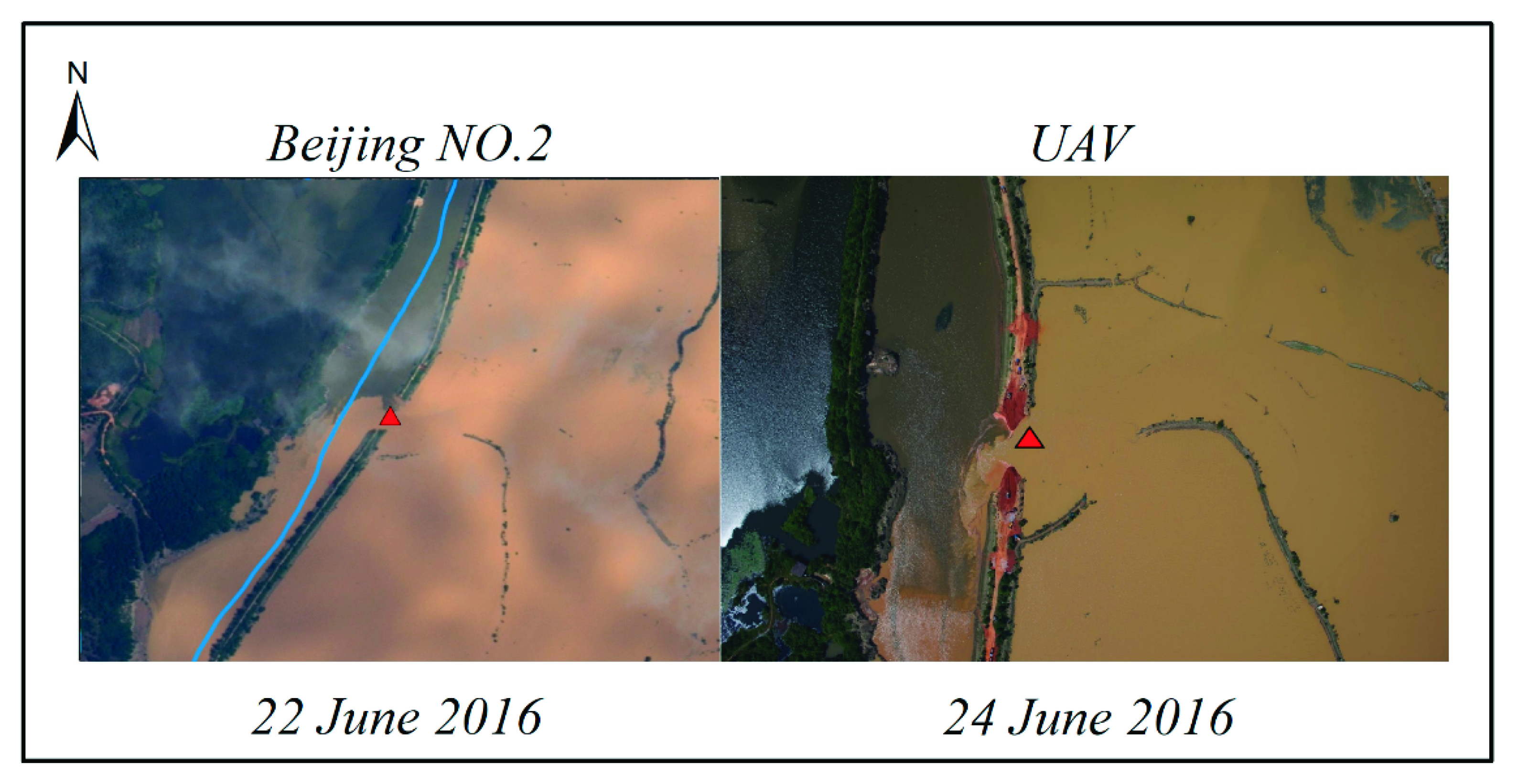
| UAV image | UAV remote sensing system | 0.13 m | June 24 | Detailed investigation of flood-stricken areas | |
| Ground survey data | June 22–24 | Field measurement | Verify the results of flood monitoring |
| Date | Air-Space-Ground Method | Ground Survey Data | Accuracy |
|---|---|---|---|
| 22 June 2016 | 65 | 64 | 98.46% |
| 24 June 2016 | 34.7 | 34 | 97.98% |
Publisher’s Note: MDPI stays neutral with regard to jurisdictional claims in published maps and institutional affiliations. |
© 2022 by the authors. Licensee MDPI, Basel, Switzerland. This article is an open access article distributed under the terms and conditions of the Creative Commons Attribution (CC BY) license (https://creativecommons.org/licenses/by/4.0/).
Share and Cite
Lei, T.; Wang, J.; Li, X.; Wang, W.; Shao, C.; Liu, B. Flood Disaster Monitoring and Emergency Assessment Based on Multi-Source Remote Sensing Observations. Water 2022, 14, 2207. https://doi.org/10.3390/w14142207
Lei T, Wang J, Li X, Wang W, Shao C, Liu B. Flood Disaster Monitoring and Emergency Assessment Based on Multi-Source Remote Sensing Observations. Water. 2022; 14(14):2207. https://doi.org/10.3390/w14142207
Chicago/Turabian StyleLei, Tianjie, Jiabao Wang, Xiangyu Li, Weiwei Wang, Changliang Shao, and Baoyin Liu. 2022. "Flood Disaster Monitoring and Emergency Assessment Based on Multi-Source Remote Sensing Observations" Water 14, no. 14: 2207. https://doi.org/10.3390/w14142207
APA StyleLei, T., Wang, J., Li, X., Wang, W., Shao, C., & Liu, B. (2022). Flood Disaster Monitoring and Emergency Assessment Based on Multi-Source Remote Sensing Observations. Water, 14(14), 2207. https://doi.org/10.3390/w14142207