
Spatial Estimates of Flood Damage and Risk Are Influenced by the Underpinning DEM Resolution: A Case Study in Kuala Lumpur, Malaysia

 , , and
Abstract
:1. Introduction
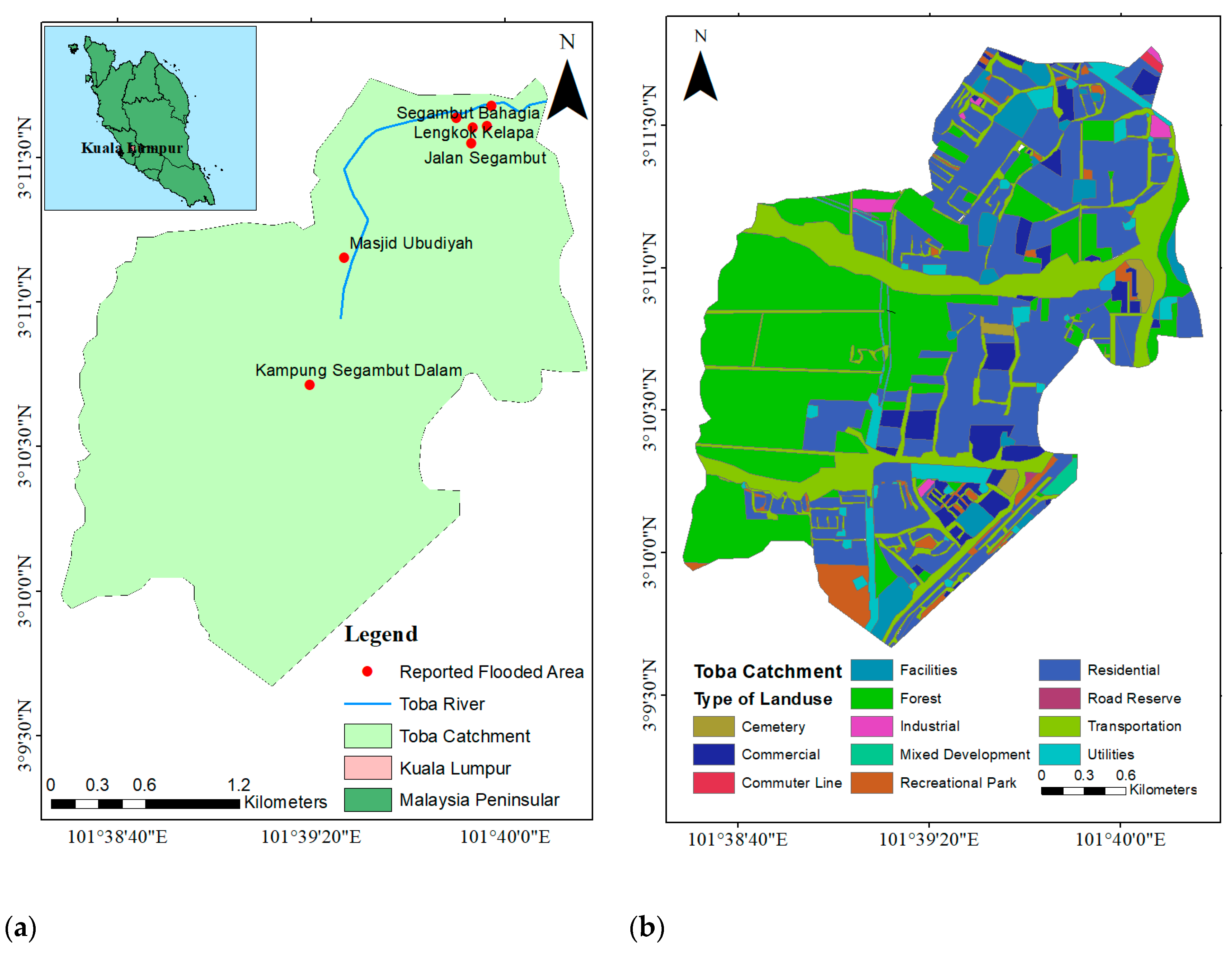
2. Study Area
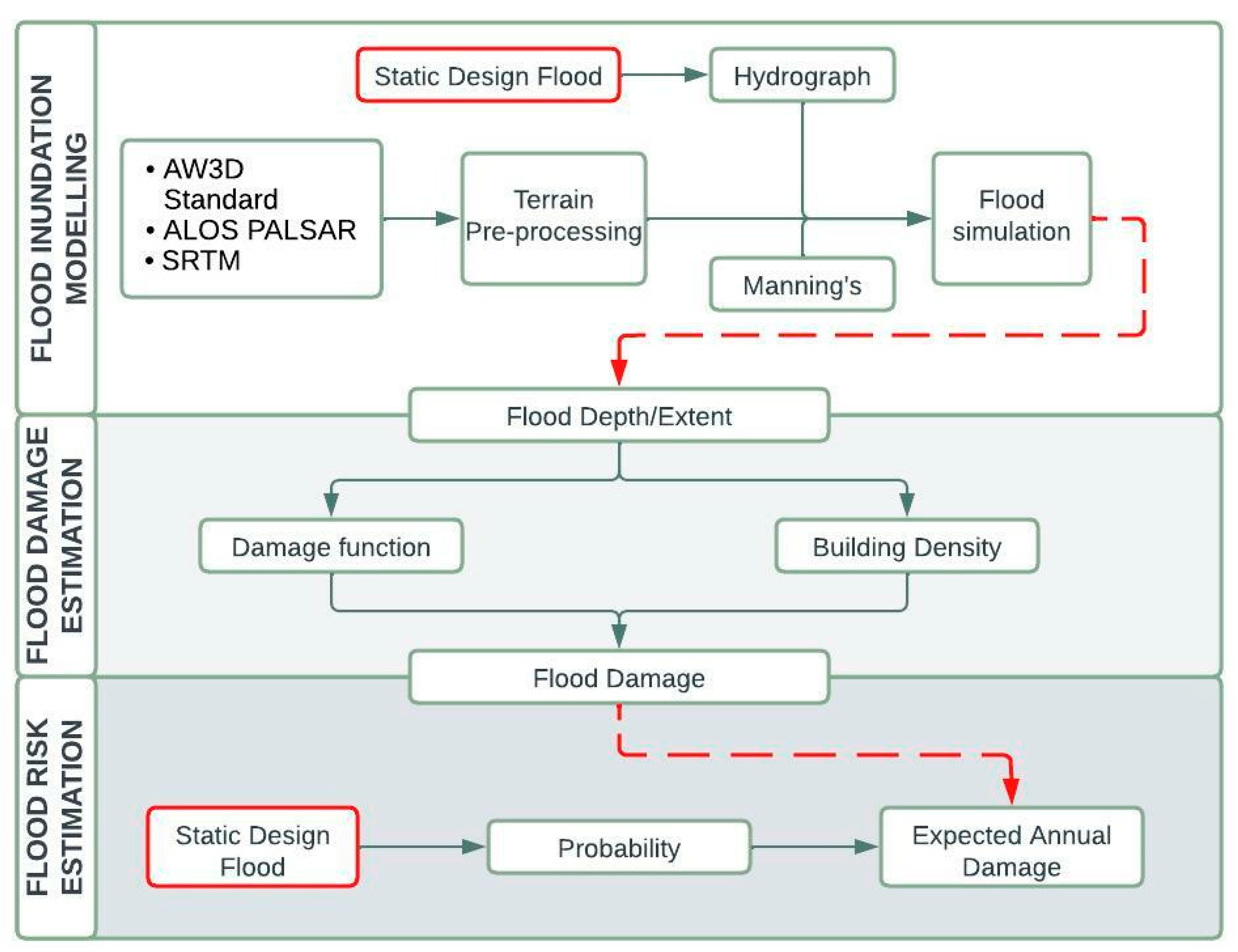
3. Methodology and Data
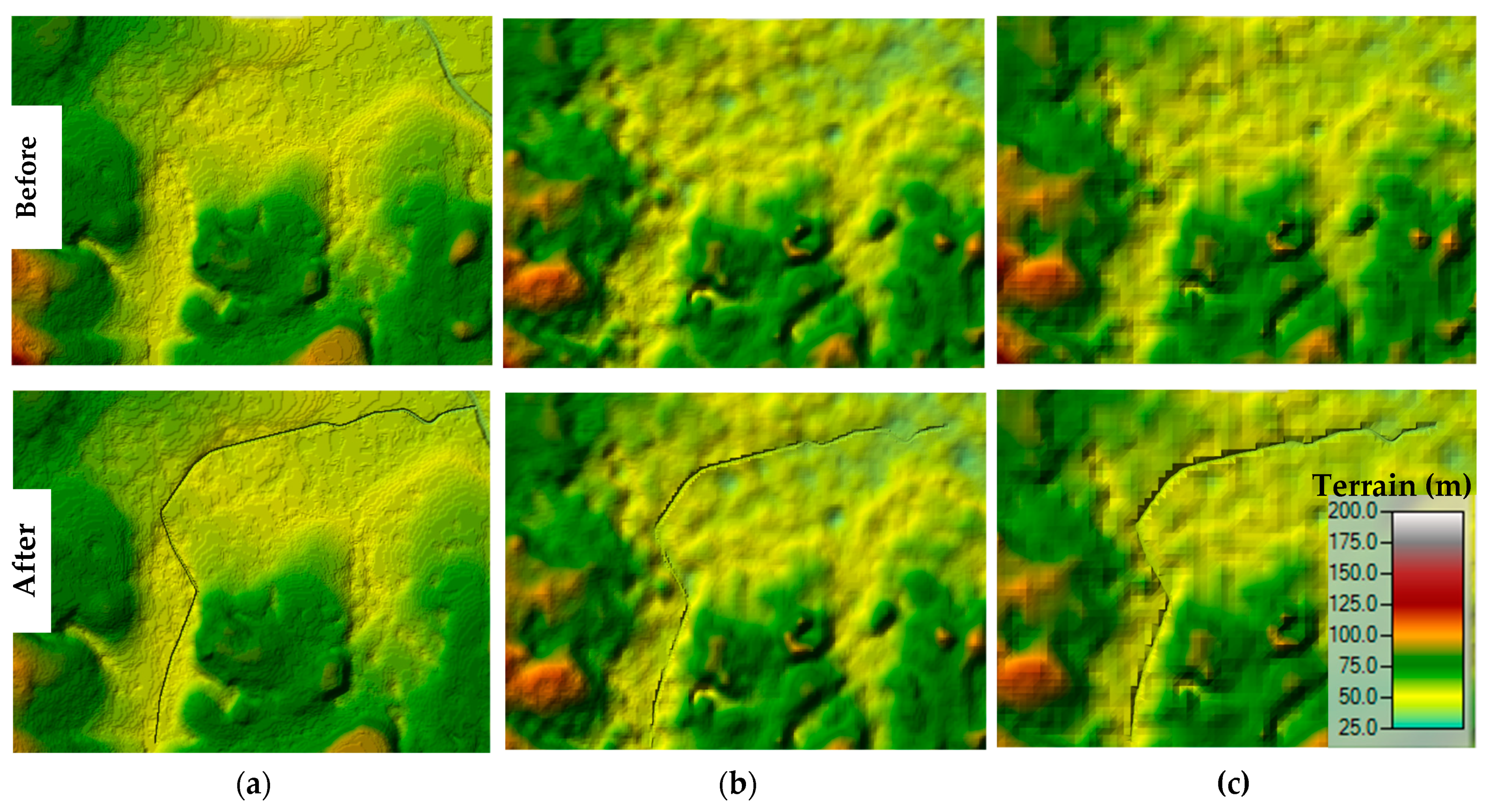
3.1. DEM Data
3.2. Flow Data
3.3. Land Use, Cross-Sections and Manning’s Data
3.4. Flood Inundation Modelling
3.5. Flood Damage Estimation
3.5.1. Depth–Damage Relationship
3.5.2. Direct Damage of Flood
3.6. Flood Risk Estimation
4. Results and Discussion
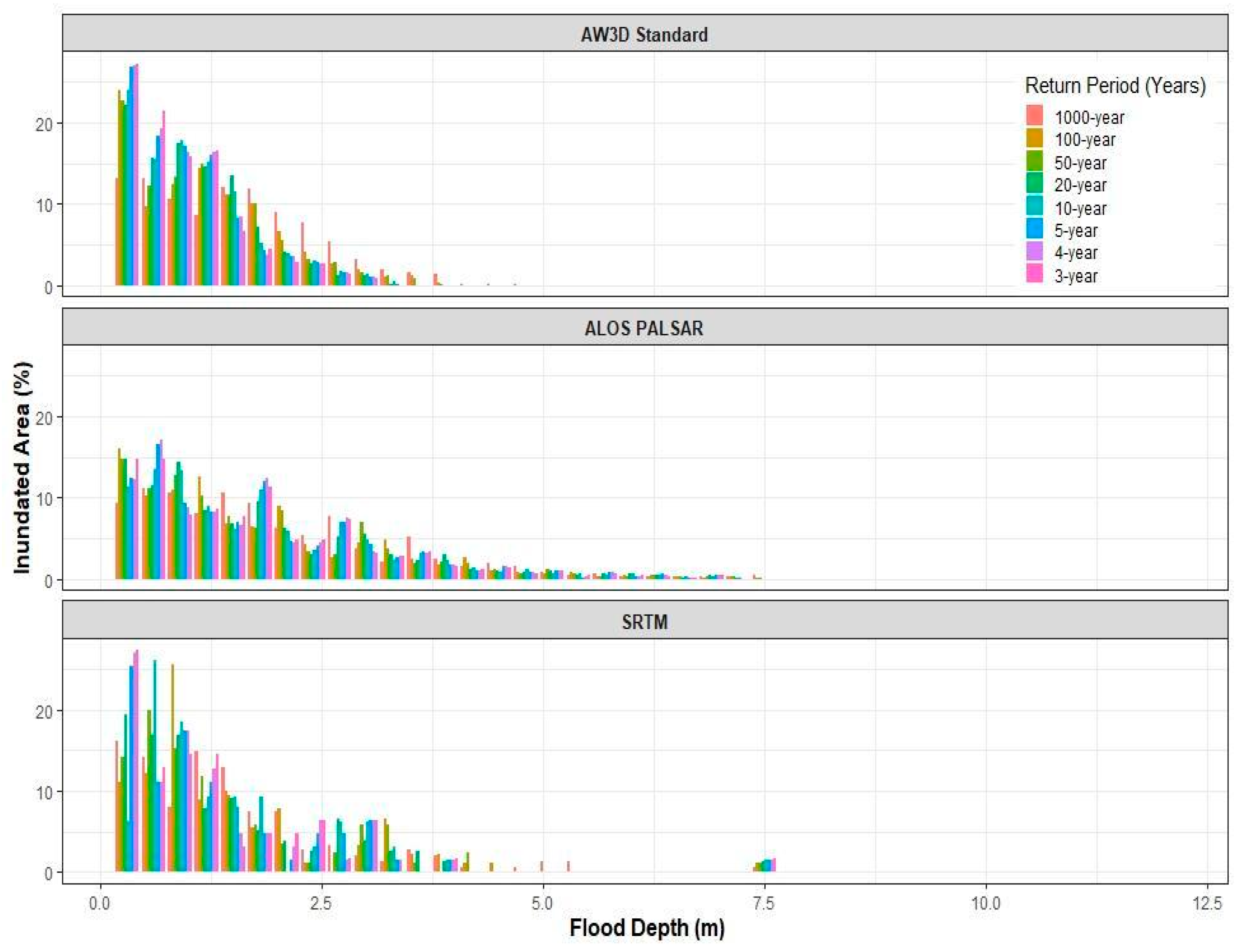
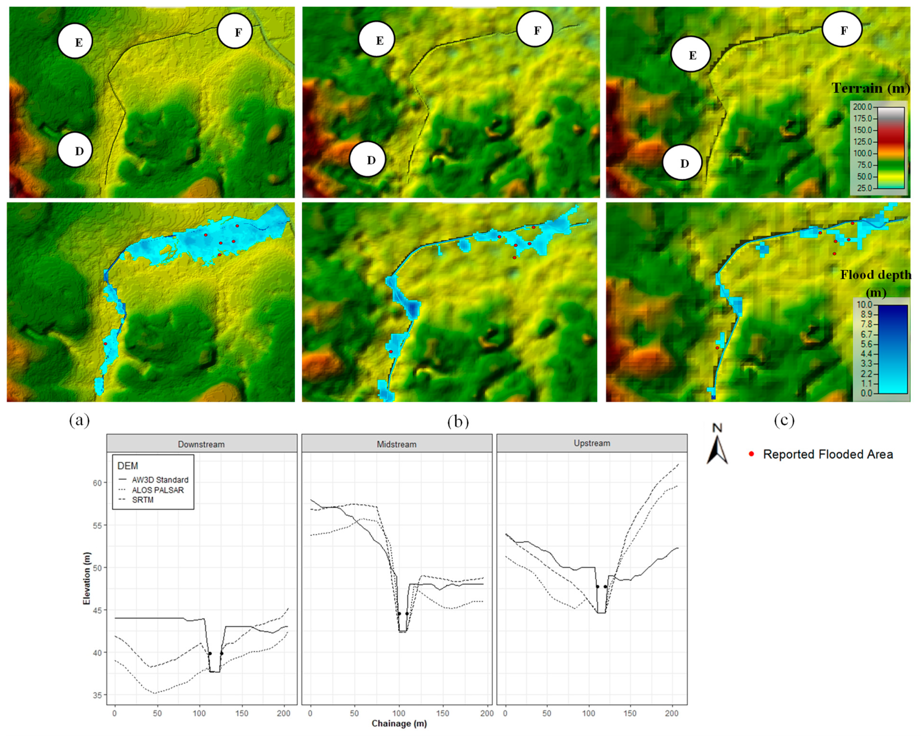
4.1. Flood Inundations
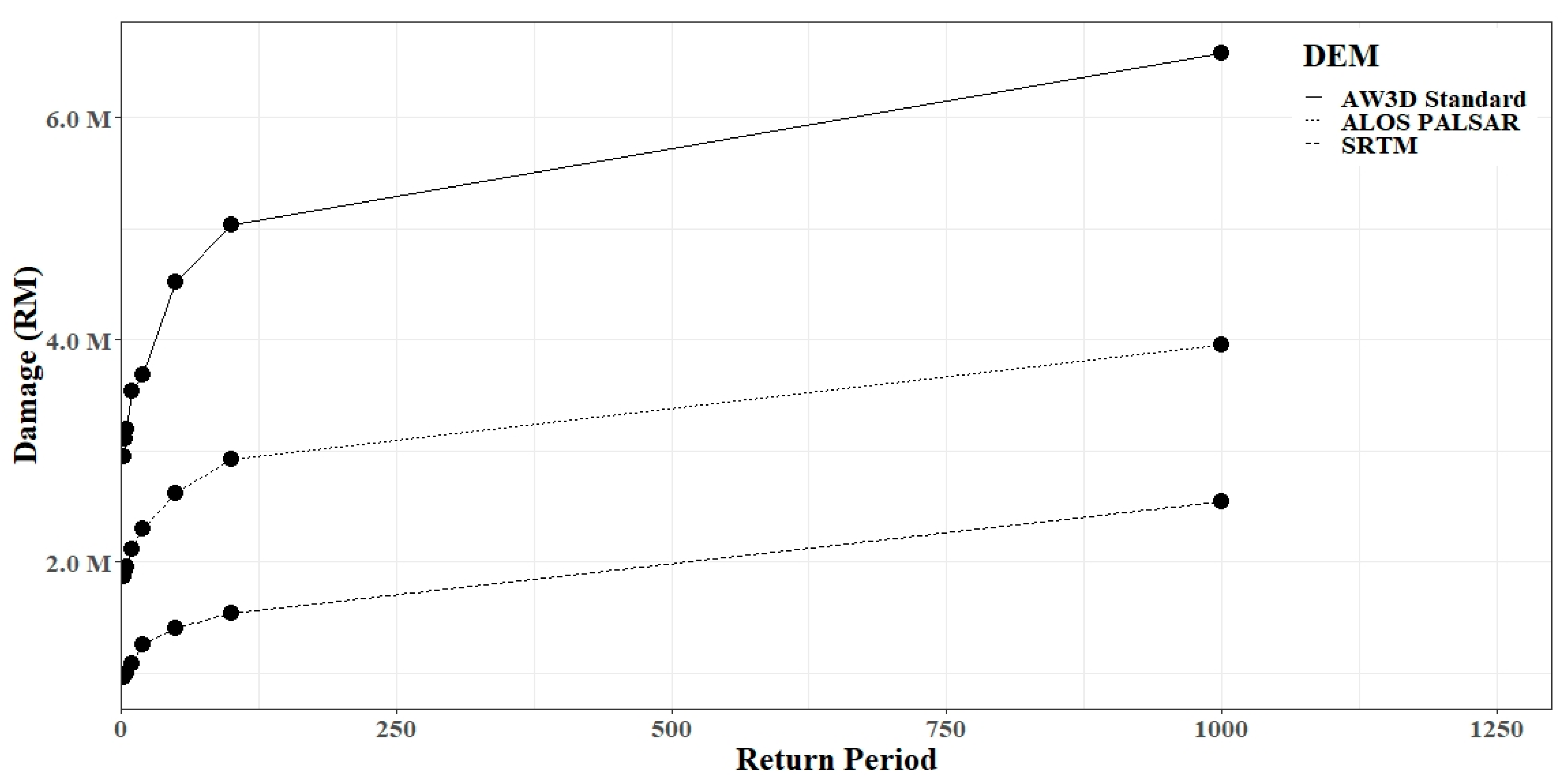
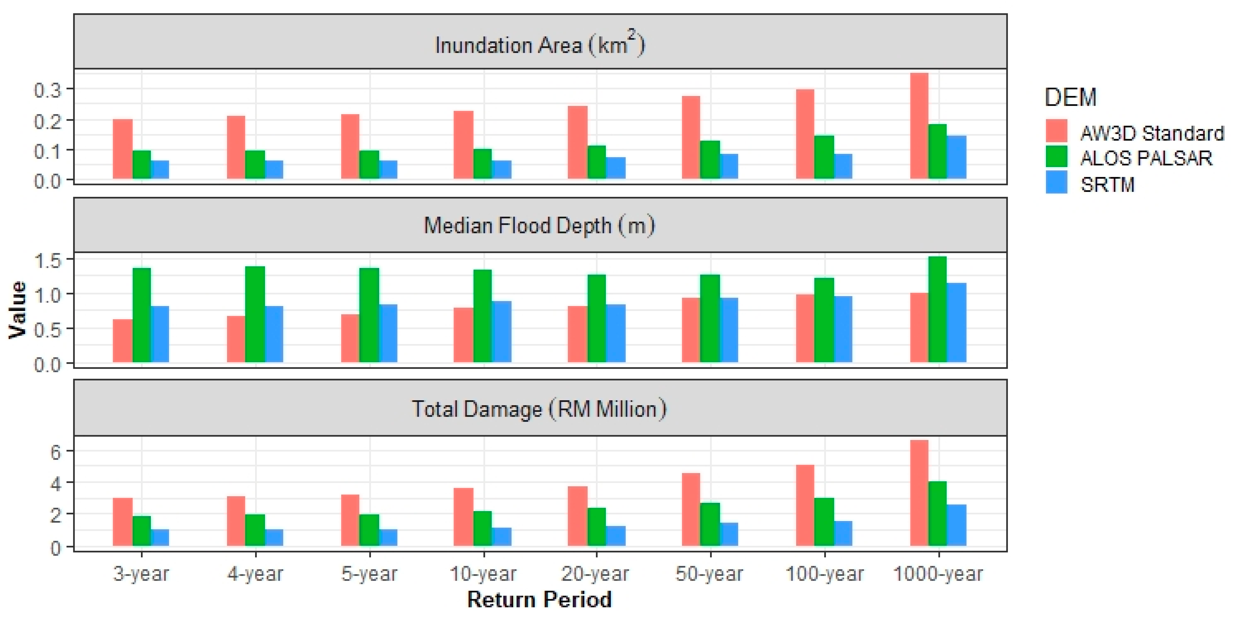
4.2. Estimation of Flood Damage and Risk
4.3. Limitations and Recommendations for Future Works
5. Conclusions
Author Contributions
Funding
Institutional Review Board Statement
Informed Consent Statement
Data Availability Statement
Acknowledgments
Conflicts of Interest
Appendix A
- ALOS PALSAR DEM: https://search.asf.alaska.edu/#/ (accessed on 22 June 2020).
- SRTM DEM: https://earthexplorer.usgs.gov/ (accessed on 22 June 2020).
References
- United Nations Office for Disaster Risk Reduction (UNISDR); Centre for Research on the Epidemiology (CRED). Economic Losses, Poverty and Disasters 1998–2017; United Nations Office for Disaster Risk Reduction: Geneva, Switzerland, 2017. [Google Scholar]
- Jongman, B.; Ward, P.J.; Aerts, J.C.J.H. Global Exposure to River and Coastal Flooding: Long Term Trends and Changes. Glob. Environ. Chang. 2012, 22, 823–835. [Google Scholar] [CrossRef]
- Jha, A.K.; Bloch, R.; Lamond, J. Cities and Flooding: A Guide to Integrated Urban Flood Risk Management for the 21st Century; The World Bank: Washington, DC, USA, 2012. [Google Scholar]
- Salman, A.M.; Li, Y. Flood Risk Assessment, Future Trend Modeling, and Risk Communication: A Review of Ongoing Research. Nat. Hazards Rev. 2018, 19, 04018011. [Google Scholar] [CrossRef]
- Quesada-Román, A. Flood Risk Index Development at the Municipal Level in Costa Rica: A Methodological Framework. Environ. Sci. Policy 2022, 133, 98–106. [Google Scholar] [CrossRef]
- Aroca-Jiménez, E.; Bodoque, J.M.; García, J.A. How to Construct and Validate an Integrated Socio-Economic Vulnerability Index: Implementation at Regional Scale in Urban Areas Prone to Flash Flooding. Sci. Total Environ. 2020, 746, 140905. [Google Scholar] [CrossRef] [PubMed]
- Prakash Mohanty, M.; Nithya, S.; Nair, A.S.; Indu, J.; Ghosh, S.; Mohan Bhatt, C.; Srinivasa Rao, G.; Karmakar, S. Sensitivity of Various Topographic Data in Flood Management: Implications on Inundation Mapping over Large Data-Scarce Regions. J. Hydrol. 2020, 590, 125523. [Google Scholar] [CrossRef]
- Granados-Bolaños, S.; Quesada-Román, A.; Alvarado, G.E. Low-Cost UAV Applications in Dynamic Tropical Volcanic Landforms. J. Volcanol. Geotherm. Res. 2021, 410, 107143. [Google Scholar] [CrossRef]
- Yan, K.; Tarpanelli, A.; Balint, G.; Moramarco, T.; Baldassarre, G. Di Exploring the Potential of SRTM Topography and Radar Altimetry to Support Flood Propagation Modeling: Danube Case Study. J. Hydrol. Eng. 2015, 20, 04014048. [Google Scholar] [CrossRef]
- McClean, F.; Dawson, R.; Kilsby, C. Implications of Using Global Digital Elevation Models for Flood Risk Analysis in Cities. Water Resour. Res. 2020, 56. [Google Scholar] [CrossRef]
- Bhuyian, M.N.M.; Kalyanapu, A. Accounting Digital Elevation Uncertainty for Flood Consequence Assessment. J. Flood Risk Manag. 2018, 11, S1051–S1062. [Google Scholar] [CrossRef]
- Merz, B.; Kreibich, H.; Schwarze, R.; Thieken, A. Review Article “Assessment of Economic Flood Damage.”. Nat. Hazards Earth Syst. Sci. 2010, 10, 1697–1724. [Google Scholar] [CrossRef]
- Thieken, A.H.; Apel, H.; Merz, B. Assessing the Probability of Large-Scale Flood Loss Events: A Case Study for the River Rhine, Germany. J. Flood Risk Manag. 2015, 8, 247–262. [Google Scholar] [CrossRef] [Green Version]
- Winter, B.; Schneeberger, K.; Huttenlau, M.; Stötter, J. Sources of Uncertainty in a Probabilistic Flood Risk Model. Nat. Hazards 2018, 91, 431–446. [Google Scholar] [CrossRef] [Green Version]
- Quesada-Román, A.; Ballesteros-Cánovas, J.A.; Granados-Bolaños, S.; Birkel, C.; Stoffel, M. Improving Regional Flood Risk Assessment Using Flood Frequency and Dendrogeomorphic Analyses in Mountain Catchments Impacted by Tropical Cyclones. Geomorphology 2022, 396, 108000. [Google Scholar] [CrossRef]
- Quesada-Román, A.; Villalobos-Chacón, A. Flash Flood Impacts of Hurricane Otto and Hydrometeorological Risk Mapping in Costa Rica. Geogr. Tidsskr.-Danish J. Geogr. 2020, 120, 142–155. [Google Scholar] [CrossRef]
- Pinos, J.; Orellana, D.; Timbe, L. Assessment of Microscale Economic Flood Losses in Urban and Agricultural Areas: Case Study of the Santa Bárbara River, Ecuador. Nat. Hazards 2020, 103, 2323–2337. [Google Scholar] [CrossRef]
- Zambri, A. DBKL Giat Tangani Limpahan Air Hujan 2020. Available online: https://www.wilayahku.com.my/dbkl-giat-tangani-limpahan-air-hujan/ (accessed on 10 June 2022).
- Department of Irrigation and Drainage (DID). Laporan Banjir Tahunan; Department of Irrigation and Drainage (DID): Kuala Lumpur, Malaysia, 2010–2020.
- de Moel, H.; Jongman, B.; Kreibich, H.; Merz, B.; Penning-Rowsell, E.; Ward, P.J. Flood Risk Assessments at Different Spatial Scales. Mitig. Adapt. Strateg. Glob. Chang. 2015, 20, 865–890. [Google Scholar] [CrossRef] [Green Version]
- Murnane, R.; Simpson, A.; Jongman, B. Understanding Risk: What Makes a Risk Assessment Successful? Int. J. Disaster Resil. Built Environ. 2016, 7, 186–200. [Google Scholar] [CrossRef]
- Zhou, Q.; Mikkelsen, P.S.; Halsnæs, K.; Arnbjerg-Nielsen, K. Framework for Economic Pluvial Flood Risk Assessment Considering Climate Change Effects and Adaptation Benefits. J. Hydrol. 2012, 414–415, 539–549. [Google Scholar] [CrossRef]
- Li, J.; Zhao, Y.; Bates, P.; Neal, J.; Tooth, S.; Hawker, L.; Maffei, C. Digital Elevation Models for Topographic Characterisation and Flood Flow Modelling along Low-Gradient, Terminal Dryland Rivers: A Comparison of Spaceborne Datasets for the Río Colorado, Bolivia. J. Hydrol. 2020. [Google Scholar] [CrossRef]
- Takaku, J.; Tadono, T.; Tsutsui, K.; Ichikawa, M. Validation of “AW3D” global dsm generated from alos prism. ISPRS Ann. Photogramm. Remote Sens. Spat. Inf. Sci. 2016, III–4, 25–31. [Google Scholar] [CrossRef] [Green Version]
- Takaku, J.; Tadono, T.; Tsutsui, K. Generation of High Resolution Global DSM from ALOS PRISM. Int. Arch. Photogramm. Remote Sens. Spat. Inf. Sci. 2014, XL–4, 243–248. [Google Scholar] [CrossRef] [Green Version]
- Alaska Satellite Facility Distributed Active Archive Centre. ALOS PALSAR RTC Radiometric Terrain Corrected High-Res 2014. Available online: https://search.asf.alaska.edu/#/ (accessed on 22 June 2020).
- Earth Resources Observation And Science (EROS) Center Shuttle Radar Topography Mission ({Srtm}) 1 Arc-Second Global 2017. Available online: https://earthexplorer.usgs.gov/ (accessed on 22 June 2020).
- Cook, A.; Merwade, V. Effect of Topographic Data, Geometric Configuration and Modeling Approach on Flood Inundation Mapping. J. Hydrol. 2009, 377, 131–142. [Google Scholar] [CrossRef]
- Prakash, M.; Rothauge, K.; Cleary, P.W. Modelling the Impact of Dam Failure Scenarios on Flood Inundation Using SPH. Appl. Math. Model. 2014, 38, 5515–5534. [Google Scholar] [CrossRef]
- Yan, K.; Baldassarre, G.; Di Solomatine, D.P. Exploring the Potential of SRTM Topographic Data for Flood Inundation Modelling under Uncertainty. J. Hydroinf. 2013, 15, 849–861. [Google Scholar] [CrossRef]
- Muthusamy, M.; Casado, M.R.; Butler, D.; Leinster, P. Understanding the Effects of Digital Elevation Model Resolution in Urban Fluvial Flood Modelling. J. Hydrol. 2021, 596. [Google Scholar] [CrossRef]
- Saksena, S. Investigating the Role of DEM Resolution and Accuracy on Flood Inundation Mapping. In Proceedings of the World Environmental and Water Resources Congress 2015, Austin, TX, USA, 15 May 2015; American Society of Civil Engineers: Reston, VA, USA, 2015; pp. 2236–2243. [Google Scholar]
- Kuala Lumpur City Hall. Cadangan Menyediakan Pelan Induk (Master Plan) Untuk Sistem Saliran Dan Pengurusan Air Hujan Bagi Bandaraya Kuala Lumpur; Kuala Lumpur City Hall: Kuala Lumpur, Malaysia, 2015.
- Chow, V. Te Open-Channel Hydraulics; McGraw-Hill Book Company: New York, NY, USA, 1959. [Google Scholar]
- Curtis, J. Manning’s n Values for Various Land Covers. To Use for Dam Breach Analyses by NRCS in Kansas. 2016, pp. 1–2. Available online: https://rashms.com/wp-content/uploads/2021/01/Mannings-n-values-NLCD-NRCS.pdf (accessed on 8 April 2020).
- Brunner, G.W. HEC-RAS River Analysis System, 2D Modeling User’s Manual Version 5.0. 2016, pp. 1–171. Available online: https://www.hec.usace.army.mil/software/hec-ras/documentation/HEC-RAS%205.0%202D%20Modeling%20Users%20Manual.pdf (accessed on 31 May 2020).
- Werner, M.G.F. Impact of Grid Size in GIS Based Flood Extent Mapping Using a 1D Flow Model. Phys. Chem. Earth, Part B Hydrol. Ocean. Atmos. 2001, 26, 517–522. [Google Scholar] [CrossRef]
- Horritt, M.S.; Bates, P.D. Effects of Spatial Resolution on a Raster Based Model of Flood Flow. J. Hydrol. 2001, 253, 239–249. [Google Scholar] [CrossRef]
- Bates, P.; De Roo, A.P. A Simple Raster-Based Model for Flood Inundation Simulation. J. Hydrol. 2000, 236, 54–77. [Google Scholar] [CrossRef]
- Ghimire, E. Evaluation of One-Dimensional and Two-Dimensional HEC-RAS Models for Flood Travel Time Prediction and Damage Assessment Using HAZUS-MH: A Case Study of Grand River, Ohio. Master’s Thesis, Youngstown State University, Youngstown, OH, USA, 2019. [Google Scholar]
- Casulli, V. A High-Resolution Wetting and Drying Algorithm for Free-Surface Hydrodynamics. Int. J. Numer. Methods Fluids 2009, 60, 391–408. [Google Scholar] [CrossRef]
- Martínez-Gomariz, E.; Forero-Ortiz, E.; Russo, B.; Locatelli, L.; Guerrero-Hidalga, M.; Yubero, D.; Castan, S. A Novel Expert Opinion-Based Approach to Compute Estimations of Flood Damage to Property in Dense Urban Environments. Barcelona Case Study. J. Hydrol. 2021, 598, 126244. [Google Scholar] [CrossRef]
- Notaro, V.; De Marchis, M.; Fontanazza, C.M.; La Loggia, G.; Puleo, V.; Freni, G. The Effect of Damage Functions on Urban Flood Damage Appraisal. Procedia Eng. 2014, 70, 1251–1260. [Google Scholar] [CrossRef] [Green Version]
- Rehan, B.M. An Innovative Micro-Scale Approach for Vulnerability and Flood Risk Assessment with the Application to Property-Level Protection Adoptions. Nat. Hazards 2018, 91, 1039–1057. [Google Scholar] [CrossRef] [Green Version]
- Romali, N.S.; Yusop, Z. Flood Damage and Risk Assessment for Urban Area in Malaysia. Hydrol. Res. 2021, 52, 142–159. [Google Scholar] [CrossRef]
- Wagenaar, D.J.; Dahm, R.J.; Diermanse, F.L.M.; Dias, W.P.S.; Dissanayake, D.M.S.S.; Vajja, H.P.; Gehrels, J.C.; Bouwer, L.M. Evaluating Adaptation Measures for Reducing Flood Risk: A Case Study in the City of Colombo, Sri Lanka. Int. J. Disaster Risk Reduct. 2019, 37, 101162. [Google Scholar] [CrossRef]
- Wang, H.; Zhou, J.; Tang, Y.; Liu, Z.; Kang, A.; Chen, B. Flood Economic Assessment of Structural Measure Based on Integrated Flood Risk Management: A Case Study in Beijing. J. Environ. Manage. 2021, 280, 111701. [Google Scholar] [CrossRef] [PubMed]
- Freni, G.; La Loggia, G.; Notaro, V. Uncertainty in Urban Flood Damage Assessment Due to Urban Drainage Modelling and Depth-Damage Curve Estimation. Water Sci. Technol. 2010, 61, 2979–2993. [Google Scholar] [CrossRef] [PubMed]
- Department of Irrigation and Drainage Malaysia (DID). Updating of Condition of Flooding and Flood Damage Assessment in Malaysia; National Flood Forecasting and Warning Centre (PRABN): Kuala Lumpur, Malaysia, 2012; Volume 2.
- Miller, J.; Kaelin, A.; Binti, B.; Rehan, M.; Sayers, P.; Davies, H.; Stewart, L. National Exposure & Vulnerability Data and Methods for the Malaysian Peninsula; Centre of Ecology and Hydrology: Wallingford, UK, 2020. [Google Scholar]
- Banjara, S.; Acharya, T.R.; Deuja, S.; Thapa, S. Flood Risk Mapping of Upper Bagmati Basin. Bachelor’s Thesis, Kathmandu University, Dhulikhel, Nepal, 2011. [Google Scholar]
- Pappenberger, F.; Frodsham, K.; Beven, K.; Romanowicz, R.; Matgen, P. Fuzzy Set Approach to Calibrating Distributed Flood Inundation Models Using Remote Sensing Observations. Hydrol. Earth Syst. Sci. 2007, 11, 739–752. [Google Scholar] [CrossRef] [Green Version]
- Zhang, Y. Using LiDAR-DEM Based Rapid Flood Inundation Modelling Framework to Map Floodplain Inundation Extent and Depth. J. Geogr. Sci. 2020, 30, 1649–1663. [Google Scholar] [CrossRef]
- Xu, K.; Fang, J.; Fang, Y.; Sun, Q.; Wu, C.; Liu, M. The Importance of Digital Elevation Model Selection in Flood Simulation and a Proposed Method to Reduce DEM Errors: A Case Study in Shanghai. Int. J. Disaster Risk Sci. 2021, 12, 890–902. [Google Scholar] [CrossRef]
- Garrote, J. Free Global DEMs and Flood Modelling—A Comparison Analysis for the January 2015 Flooding Event in Mocuba City (Mozambique). Water 2022, 14, 176. [Google Scholar] [CrossRef]
- Hsu, Y.C.; Prinsen, G.; Bouaziz, L.; Lin, Y.J.; Dahm, R. An Investigation of DEM Resolution Influence on Flood Inundation Simulation. Procedia Eng. 2016, 154, 826–834. [Google Scholar] [CrossRef]
- Saksena, S.; Merwade, V. Incorporating the Effect of DEM Resolution and Accuracy for Improved Flood Inundation Mapping. J. Hydrol. 2015, 530, 180–194. [Google Scholar] [CrossRef] [Green Version]
- Sanders, B.F. Evaluation of On-Line DEMs for Flood Inundation Modeling. Adv. Water Resour. 2007, 30, 1831–1843. [Google Scholar] [CrossRef]
- Yan, K.; Di Baldassarre, G.; Solomatine, D.P.; Schumann, G.J.P. A Review of Low-Cost Space-Borne Data for Flood Modelling: Topography, Flood Extent and Water Level. Hydrol. Process. 2015, 29, 3368–3387. [Google Scholar] [CrossRef]
- Nafari, R.H. Flood Damage Assessment in Urban Areas. Ph.D. Thesis, University of Melbourne, Melbourne, Australia, 2018. [Google Scholar]
- Vozinaki, A.-E.K.; Karatzas, G.P.; Sibetheros, I.A.; Varouchakis, E.A. An Agricultural Flash Flood Loss Estimation Methodology: The Case Study of the Koiliaris Basin (Greece), February 2003 Flood. Nat. Hazards 2015, 79, 899–920. [Google Scholar] [CrossRef]
- Zahari, R.K.; Ariffin, R.N.R. Risk Communications: Flood-Prone Communities of Kuala Lumpur. Procedia Environ. Sci. 2013, 17, 880–888. [Google Scholar] [CrossRef] [Green Version]
- Ward, P.J.; de Moel, H.; Aerts, J.C.J.H. How Are Flood Risk Estimates Affected by the Choice of Return-Periods? Nat. Hazards Earth Syst. Sci. 2011, 11, 3181–3195. [Google Scholar] [CrossRef] [Green Version]
- Hawker, L.; Rougier, J.; Neal, J.; Bates, P.; Archer, L.; Yamazaki, D. Implications of Simulating Global Digital Elevation Models for Flood Inundation Studies. Water Resour. Res. 2018, 54, 7910–7928. [Google Scholar] [CrossRef] [Green Version]


| Reported Locations | Date of Occurrence | Reported Depth (m) | Rainfall Information | |
|---|---|---|---|---|
| Storm Duration (h) | Probability of Exceedance 1 | |||
| Masjid Ubudiyah | 6-Feb-09 | 0.5 | n.a.2 | n.a. |
| 14-Oct-19 | 0.3–0.9 | 1 | 88 | |
| 14-Feb-20 | 0.1–0.9 | 1.5 | 38 | |
| 18-Jul-20 | 0.3 | n.a. | n.a. | |
| Jalan Segambut | 18-Apr-12 | 0.3–0.6 | 3 | n.a. |
| 16-Sep-16 | 0.3–1.0 | n.a. | n.a. | |
| Jalan Kelapa Muda | 18-Apr-12 | 0.3–0.6 | 3 | n.a. |
| 21-Aug-12 | 0.3–0.6 | 3 | n.a. | |
| 16-Sep-16 | 0.3–1.0 | n.a. | n.a. | |
| 3-Apr-18 | 0.2–0.5 | 1 | 0 | |
| Segambut Bahagia | 18-Apr-12 | 0.3–0.6 | 3 | n.a. |
| 21-Aug-12 | 0.3–0.6 | 3 | n.a. | |
| 12-Sep-12 | 0.3–0.6 | 3 | n.a. | |
| 6-May-13 | 0.3–0.7 | 3 | 55 | |
| 24-Apr-14 | 0.4–1.0 | n.a. | n.a. | |
| 13-Aug-15 | 1.5 | 1 | 29 | |
| 4-Sep-15 | 0.3 | n.a. | n.a. | |
| 15-Nov-15 | 0.3–0.6 | 1 | n.a. | |
| 4-Mar-16 | 0.3–0.6 | 1.5 | 30 | |
| 16-Sep-16 | 0.3–1.0 | n.a. | n.a. | |
| Segambut | 10-Apr-13 | 0.3–0.5 | 2 | 15 |
| 0.3–0.6 | 2 | 20 | ||
| 3-May-13 | 0.3–0.7 | 1 | 70 | |
| 10-Oct-13 | 0.3 | 3 | 20 | |
| Segambut Dalam | 13-Aug-15 | 1.5 | 1 | 29 |
| 15-Nov-15 | 0.3–0.6 | 1 | n.a. | |
| Segambut Bahagia Tambahan | 16-Sep-16 | 0.3–1.0 | n.a. | n.a. |
| Segambut Tambahan | 26-Apr-17 | 0.3–1.0 | 2 | 13 |
| Lot 1593 Kg. Segambut Dalam | 14-Feb-20 | 0.1–0.9 | 1.5 | 38 |
| Lengkok Kelapa | 16-Sep-16 | 0.3–1.0 | n.a. | n.a. |
| Jalan Kolam Air | 4-Sep-15 | 0.3 | n.a. | n.a. |
| Return Period (Year) | Inundation Area (km2) | Median Floodplain Depth (m) | Total Damage (RM in Million) | Expected Annual Damage (RM in Million) | ||||||||
|---|---|---|---|---|---|---|---|---|---|---|---|---|
| A3 | AP | SR | A3 | AP | SR | A3 | AP | SR | A3 | AP | SR | |
| 3 | 0.20 | 0.09 | 0.06 | 0.62 | 1.36 | 0.80 | 2.95 | 1.88 | 0.96 | 1.15 | 0.70 | 0.37 |
| 4 | 0.21 | 0.09 | 0.06 | 0.67 | 1.37 | 0.80 | 3.11 | 1.93 | 0.99 | |||
| 5 | 0.21 | 0.10 | 0.06 | 0.68 | 1.35 | 0.83 | 3.2 | 1.96 | 1.00 | |||
| 10 | 0.23 | 0.10 | 0.06 | 0.78 | 1.34 | 0.89 | 3.54 | 2.11 | 1.08 | |||
| 20 | 0.24 | 0.11 | 0.07 | 0.81 | 1.25 | 0.84 | 3.68 | 2.30 | 1.25 | |||
| 50 | 0.27 | 0.13 | 0.08 | 0.93 | 1.25 | 0.92 | 4.52 | 2.62 | 1.41 | |||
| 100 | 0.30 | 0.14 | 0.09 | 0.98 | 1.21 | 0.94 | 5.03 | 2.93 | 1.54 | |||
| 1000 | 0.35 | 0.18 | 0.14 | 1.01 | 1.52 | 1.13 | 6.58 | 3.95 | 2.55 | |||
Publisher’s Note: MDPI stays neutral with regard to jurisdictional claims in published maps and institutional affiliations. |
© 2022 by the authors. Licensee MDPI, Basel, Switzerland. This article is an open access article distributed under the terms and conditions of the Creative Commons Attribution (CC BY) license (https://creativecommons.org/licenses/by/4.0/).
Share and Cite
Fatdillah, E.; Rehan, B.M.; Rameshwaran, P.; Bell, V.A.; Zulkafli, Z.; Yusuf, B.; Sayers, P. Spatial Estimates of Flood Damage and Risk Are Influenced by the Underpinning DEM Resolution: A Case Study in Kuala Lumpur, Malaysia. Water 2022, 14, 2208. https://doi.org/10.3390/w14142208
Fatdillah E, Rehan BM, Rameshwaran P, Bell VA, Zulkafli Z, Yusuf B, Sayers P. Spatial Estimates of Flood Damage and Risk Are Influenced by the Underpinning DEM Resolution: A Case Study in Kuala Lumpur, Malaysia. Water. 2022; 14(14):2208. https://doi.org/10.3390/w14142208
Chicago/Turabian StyleFatdillah, Eva, Balqis M. Rehan, Ponnambalam Rameshwaran, Victoria A. Bell, Zed Zulkafli, Badronnisa Yusuf, and Paul Sayers. 2022. "Spatial Estimates of Flood Damage and Risk Are Influenced by the Underpinning DEM Resolution: A Case Study in Kuala Lumpur, Malaysia" Water 14, no. 14: 2208. https://doi.org/10.3390/w14142208
APA StyleFatdillah, E., Rehan, B. M., Rameshwaran, P., Bell, V. A., Zulkafli, Z., Yusuf, B., & Sayers, P. (2022). Spatial Estimates of Flood Damage and Risk Are Influenced by the Underpinning DEM Resolution: A Case Study in Kuala Lumpur, Malaysia. Water, 14(14), 2208. https://doi.org/10.3390/w14142208