Hydrogeological Survey, Radiometric Analysis and Field Parametric Measurements: A Combined Tool for the Study of Porous Aquifers
Abstract
:1. Introduction
- The oxidizing zone: Uranium is in the oxidation state +6, chemically stable and highly soluble. Here, uranium acts as a conservative tracer and is enriched as (234U).
- The transition zone (downstream of the oxidizing zone): the uranium concentration and isotope ratio (234U/238U) increase.
- The reducing zone: The activity ratio (234U/238U) decreases slowly, approximately linearly, as a function of the residence time, while the uranium concentration is maintained at a relatively constant very low level [4].
2. Materials and Methods
- A structural lithological reconstruction of the study area, which may be based on bibliographic data, where there is sufficient reliable data for a medium-scale reconstruction of the structural lithological characteristics of the examination area. Otherwise, if the data available are not representative enough, this information can be obtained through a geological structural survey in the field. In each case, the surface data needs to be integrated with survey stratigraphies or indirect surveys for a more detailed reconstruction.
- The identification of the existing wells or piezometers in the examination area, which affect the same aquifer (in the case of multilayer aquifers) and whose depths, stratigraphy and construction characteristics are known and accessible for on-site measurements and the sourcing of samples. These wells or piezometers have to be distributed, as much as possible, in a homogeneous way to be representative of the studied aquifer. The set of surveyed wells will form the monitoring network for the subsequent phases.
- The monitoring of groundwater for the hydrogeological survey of the static level of the aquifer, parametric measurements of the redox potential (Eh), dissolved oxygen (O2) and groundwater temperature (T) and water sampling for radiometric investigations. The monitoring period must be extended to at least to one hydrological year which, especially in the case of phreatic shallow aquifers, reflects the local rainfall regime. The hydrogeological survey, parametric measurements taken in the field and sampling must be carried out during the periods of maximum oscillation in terms of the groundwater (flood/lean).
- The reconstruction of the piezometric surface of the aquifer from the hydrogeological survey data.
- The interpretation of the piezometric morphology, either for the identification of recharge and drainage areas in terms of the groundwater, preferential directions of water flow, underground watersheds or a qualitative estimate of hydraulic gradient (i) and transmissivity (T).
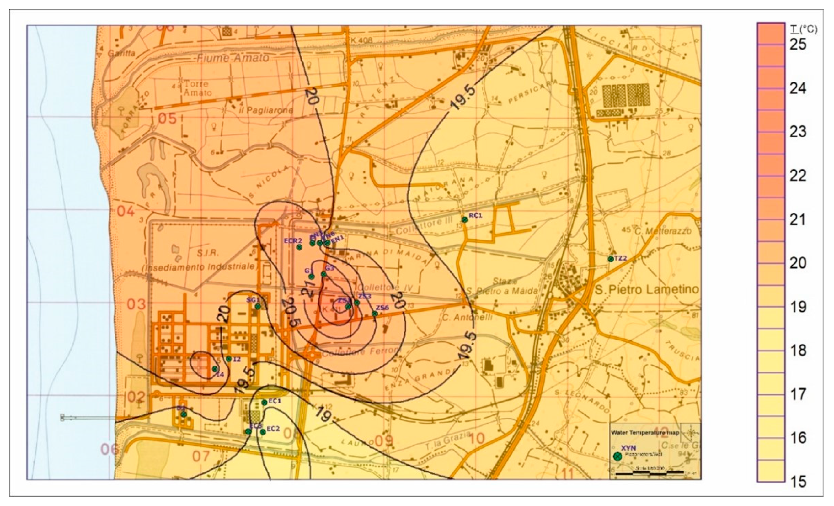
- A reconstruction of the isotherms map, for the evaluation of variations in temperature in the various sectors of the aquifer.
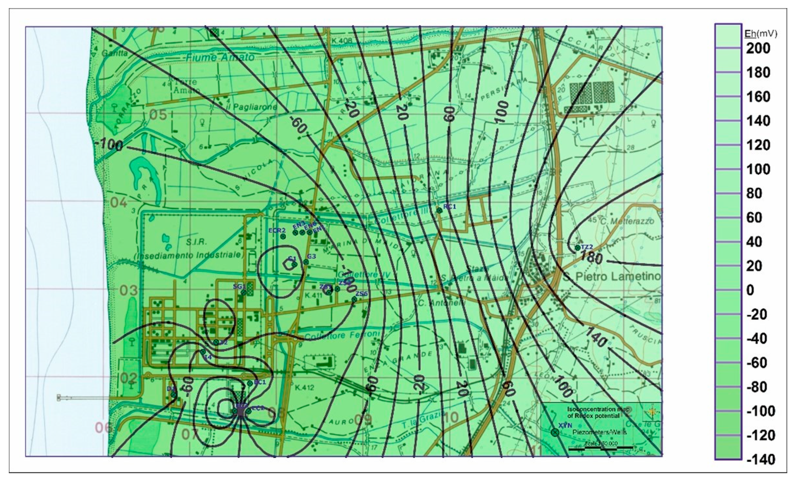
- A reconstruction of the redox isopotential map, to evaluate variations in this parameter in the different sectors of the aquifer.
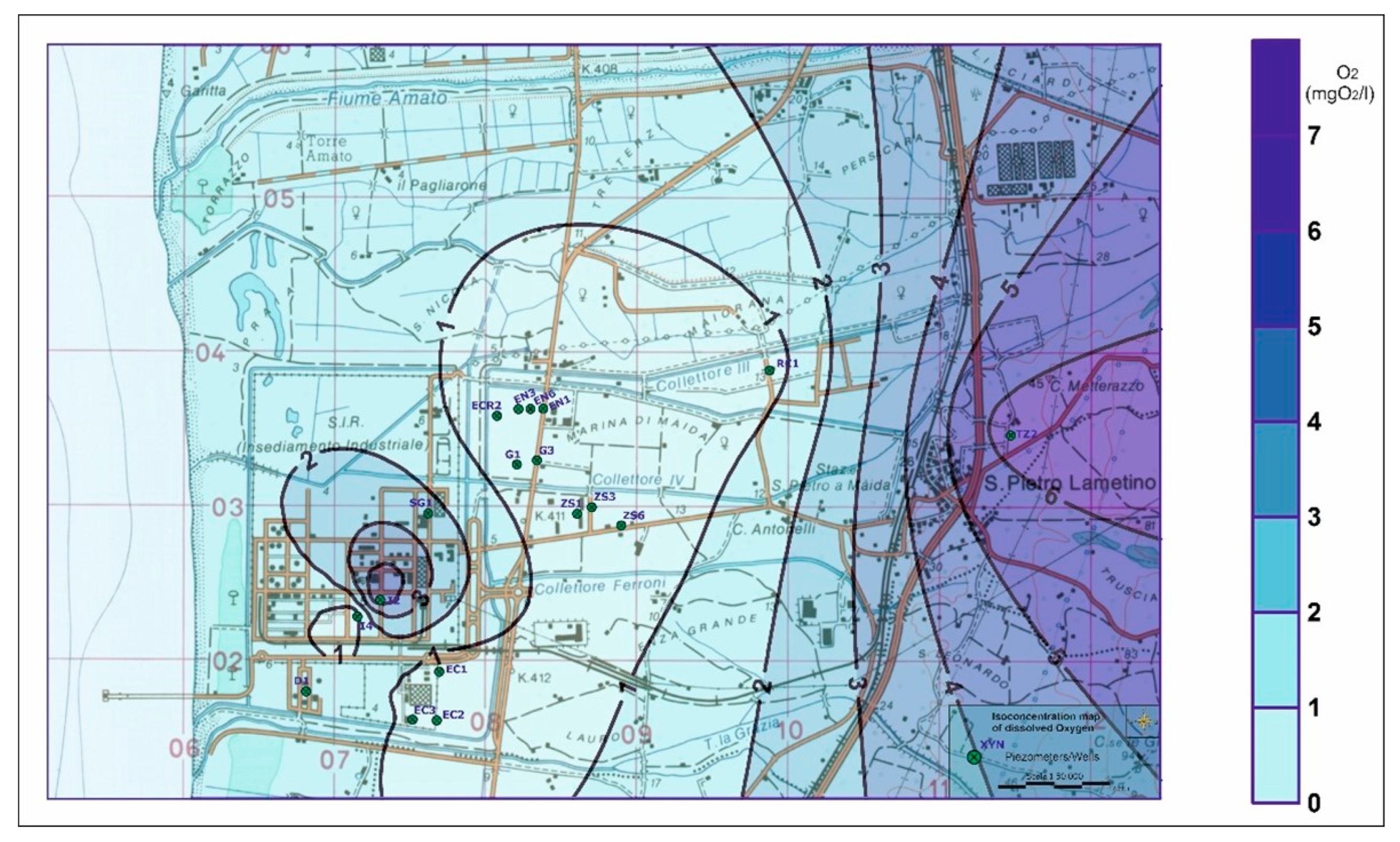
- A reconstruction of the dissolved oxygen isocentration map, to evaluate this parameter in the different sectors of the aquifer.
- The determination of radioactive tracers in water samples in the laboratory. In particular, for fluid matrices (air and water), the “volumetric or massive activity concentration” of a radioactive substance must be defined, i.e., the number of disintegrations occurring in the volume or mass unit expressed in Becquerel per liter (Bq/L), Becquerel per cubic meter (Bq/m3) or Becquerel per kilogram (Bq/kg).
- The restitution of radiometric data determined in the laboratory, with representative tables and graphs or with an isodistribution map of the radioisotopes in the various aquifer sectors. The analysis of radiometric data provides additional information to identify the recharge and drainage areas of the aquifer.
- The manometric technique for measuring radon gas, using the test procedure “Determination of the activity concentration of radon gas (222Rn) in water” performed according to the ISO method [7];
- The ICP—mass technique for the determination of the isotope ratio of 234U/238U in the samples to be analyzed using the test procedure “ASTM C1345–08—Standard Test Method for Analysis of Total and Isotopic Uranium and Total Thorium in Soils by Inductively Coupled Plasma-Mass Spectrometry” [8].
3. Results
3.1. Methodology Application—Case Study
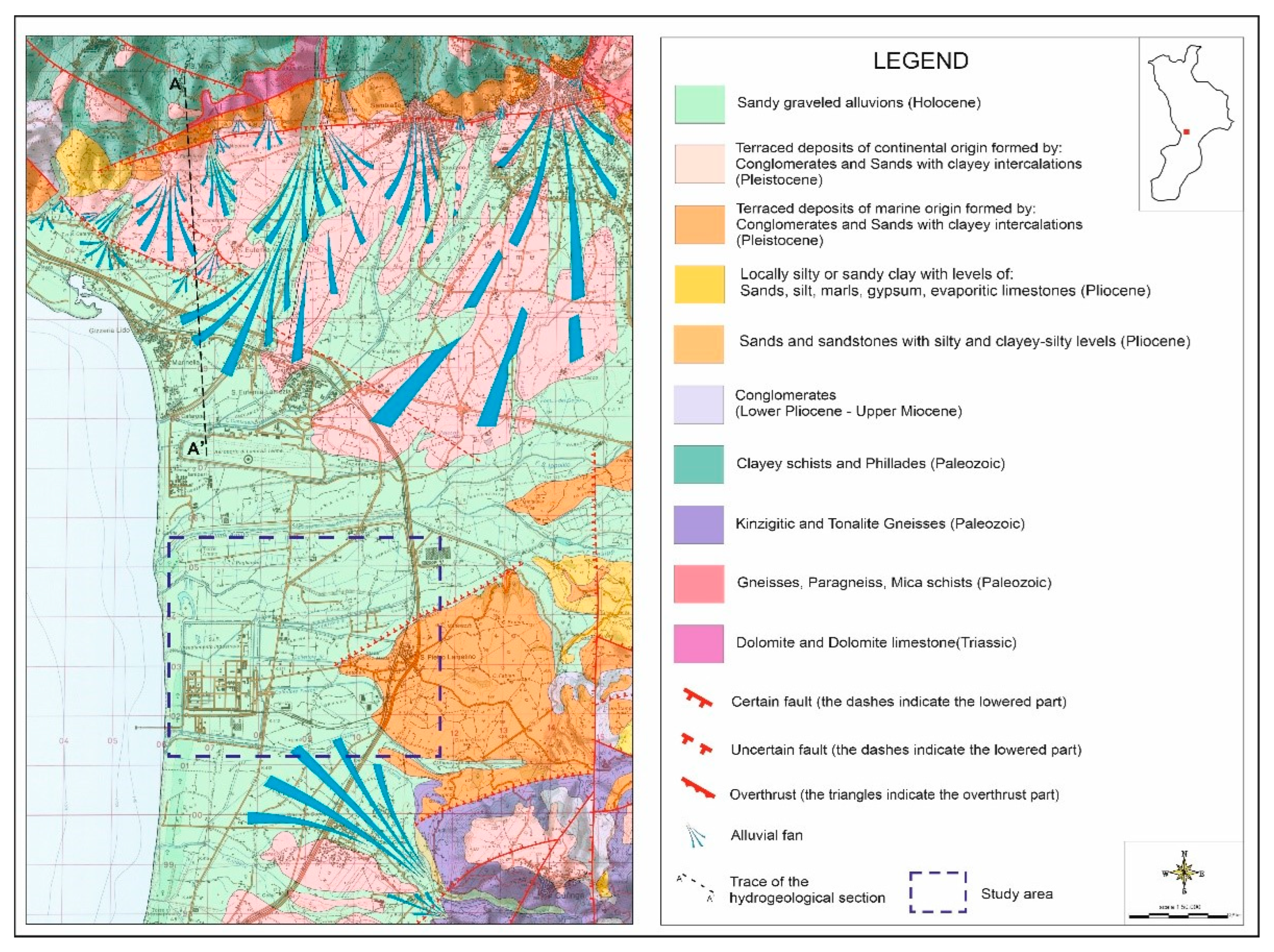
3.1.1. Geological, Lithological–Structural and Hydrogeological General Framework of Study Area
3.1.2. Hydrogeological Survey—Construction of the Piezometric Map
3.1.3. Analysis of Parametric Data Detected in the Field
3.1.4. Radiometric Analyses
4. Discussion
- -
- A recharging area, located in the innermost zones of the northern sector where the rivers feed the shallow aquifer, with reduced hydraulic paths, high differences in levels, low transmissivity and hydraulic conductivity.
- -
- A draining area in the coastal strip of the study area where the shallow aquifer feeds the rivers characterized by greater hydraulic paths and low gradients, high transmissivity and hydraulic conductivity.
- -
- A transition area located between the previous two where the characters described progressively vary from East to West while passing from one zone to another.
- -
- An innermost area, corresponding to the well (PZT2), where positive values in terms of the redox potential show the presence of an oxygenated area.
- -
- An external area along the coast, roughly between the piezometer (PZS6) and the well (PZD1), characterized by negative redox potential values, indicating the presence of a poorly oxygenated area in reducing conditions.
- -
- A transition zone, whose boundaries cannot be clearly defined, which lies between the other two areas and is roughly located between the well (PZRC1) and the piezometer (PZS6), where a progressive transition in terms of the redox potential towards negative values is observed.
- -
- An internal area, where high redox potential (Eh) and dissolved oxygen (O2) values indicate the presence of an oxygenated area.
- -
- An external area along the coast characterized by low Eh and O2 values, which indicate the presence of a poorly oxygenated area in reducing conditions.
- -
- A transition zone, whose boundaries cannot be clearly defined, which lies between the first two, where the progressive passage of the redox potential towards negative values corresponds to the decrease in the concentrations of dissolved oxygen.
5. Conclusions
- -
- A more internal sector characterized by colder and more mobile, well-oxygenated waters, with a positive redox potential, high value in terms of the uranium isotope ratio and high concentrations in terms of radon volumetric activity, with denser and convex isopiezometric lines, showing high hydraulic gradients and low transmissivity, and flow lines oriented towards the coast. This sector corresponds to the groundwater recharge area since these characteristics are common to the recharge areas of alluvial aquifers.
- -
- A coastal sector characterized by: warmer and slower waters, which are poorly oxygenated with a negative redox potential, low values in terms of the uranium isotope ratio and a low concentration in terms of radon volumetric activity, distinguished by more sparse and concave isopiezometric lines, showing low hydraulic gradients and high transmissivity, with flowing lines towards the coast. This sector corresponds to the drainage areas of the aquifer, as these characteristics are common in the drainage areas of alluvial aquifers. Furthermore, in this sector, from the available stratigraphies, the presence of peat was observed, which, acting as redox driver, amplifies the reaction, making Eh values more negative. Finally, also in this sector, by crossing the hydrogeological and temperature survey data, the paleo riverbed of the Turrina torrent was identified, with a NW–SE vergence.
- -
- A central sector characterized by intermediate values lying between those found in the two previous sectors for all the tracers used.
Author Contributions
Funding
Institutional Review Board Statement
Informed Consent Statement
Data Availability Statement
Conflicts of Interest
References
- Cuiuli, E. Quick analysis of the characteristic hydrogeological parameters of an aquifer, using empirical forumlas and the implementation of the clay substrate map: The case study of the shallow aquifer of the S. Eufemia Lamezia plain (Central Calabria, Italy). Acque Sotter. Ital. J. Groundw. 2018, 4/154, 61–71. [Google Scholar] [CrossRef]
- Di Sabatino, V.; Manetta, M.; Sciannamblo, D.; Spizzico, M.; Tallini, M. Radon as a spring water tracer aimed at the vulnerability of complex carbonate aquifers: The example of the Rio Arno spring group (Gran Sasso, central Italy). Gior. di Geol. Appl. 2005, 2, 413–419. [Google Scholar] [CrossRef]
- UNSCEAR—VV.AA. Sources and Effects of Ionising Radiation—Annex B; United Nations: New York, NY, USA, 1977; 727p. [Google Scholar]
- Mebus Geyl. Enviromental Isotopes in the Hydrogeological Cycle—Principles and Applications; UNESCO: Paris, France, 2000; Volume IV, 196p. [Google Scholar]
- IUPAC. Data Series: Krypton, Xenon and Radon Gas-Solubilities; Clever, H.L., Ed.; Pergamon Press: Oxford, UK, 1979; Volume 2, 35p, ISBN 9781483285481. [Google Scholar]
- Cuiuli, E.; Costabile, A.; Reillo, O.; Migliorino, C. Study of anomalous concentration values of pollutants found in groundwater of Lamezia Terme Industrial Zone—Final Report. 2019; Agreement between Environment department of Calabria region and Regional Agency for the Protection of the Environment of Calabria (Rep.Reg. 689/17). Internal Document—Unpublished. [Google Scholar]
- ISO Standard n. 13164-3; Water Quality—Radon-222—Part 3: Test Method Using Emanometry. ISO—International Organization for Standardization: Geneva, Switzerland, 2013.
- Method C1345-08; Standard Test Method for Analysis of Total and Isotopic Uranium and Total Thorium in Soils by Inductively Coupled Plasma-Mass Spectrometry. ASTM: West Conshohocken, PA, USA, 2008.
- Amodio Morelli, L.; Bonardi, G.; Colonna, V.; Dietrich, D.; Giunta, G.; Ippolito, F.; Liguori, V.; Lorenzoni, S.; Paglionico, A.; Perrone, V.; et al. The Calabrian-Peloritanian Arc in the Apennine-Magrebid orogen. Mem. Soc. Geol. It. 1976, 17, 1–60. [Google Scholar]
- Gullà, G.; Antronico, L.; Sorriso-Valvo, M.; Tansi, C. Methodological proposal for the evaluation of indicators of hazard and landslide risk at intermediate scales: The area of the Catanzaro Graben (Calabria—Italy). Geol. Rom. 2005, 38, 97–121. [Google Scholar]
- Cuiuli, E. Remarks on the hydrogeological setting of S. Eufemia Lamezia Plain through the developement of the top surface of the intermediate confined aquifer. Acq. Sott. It. J. Groundwat. 2015, 141/3, 45–52. [Google Scholar] [CrossRef] [Green Version]
- Mouton, J. Special Project 26—Organic Study of Water Resources in Calabria—Atlas of Piezometric and Water Quality Maps (sc.1:25,000); Cassa per il Mezzogiorno; Poligrafica: Ercolano, Italy, 1978; 180p. [Google Scholar]
- Sappa, G.; Bianchini, B. Hydrogeological characterization of the S. Eufemia Plain using thermocoductometric methods. Ing. Geol. Degli Aquiferi 1999, 13, 19–294. [Google Scholar]
- Cuiuli, E. Contribution to the knowledge of the hydrogeological characteristics of S. Eufemia Lamezia Plain (Calabria)—First Results. Acq. Sott. It. J. Grounwat. 2012, 127, 19–32. [Google Scholar]
- Cuiuli, E. The intrinsic vulnerability map of the surface aquifer of the S. Eufemia Lamezia Plain (Calabria). Acq. Sott. It. J. Grounwat. 2013, 132/2, 15–23. [Google Scholar] [CrossRef]
- Celico, P.; De Vita, P.; Monacelli, G.; Scalise, A.R.; Tranfaglia, G. Illustrative Notes of the Hydrogeological Map of Southern Italy. [sc. 1:250,000]; APAT—Univ. Fed. II Na; Istituto Poligrafico e Zecca dello Stato S.p.A.: Roma, Italy, 2007; 211p, ISBN 88-448-0215-5. [Google Scholar]
- Castany, G. Prospection et Espoitation des Eaux Souterraines; Dunot: Paris, Italy, 1968; 718p. [Google Scholar]
- Celico, P. Hydrogeological Prospecting; Liguori Editore: Naples, Italy, 1986; Volume 1, 735p, ISBN 88-207-1331-4. [Google Scholar]
- Rotiroti, M.; Bonomi, T.; Fumagalli, L.; Azzoni, A.; Pisaroni, B.; Demicheli, G. Methodological approach in the analysis of Arsenic, Iron and Manganese contamination phenomena in shallow aquifer, the case of the Cremona area. Eng. Hydro Environ. Geol. 2012, 15, 117–128. [Google Scholar] [CrossRef]
- Israelson, C.; Bjork, S.; Hawkesworth, C.J.; Noe Nygaard, N. Uranium-series isotopes from Eemian lake deposits, Hollemp, Denmark. Bull. Geol. Soc. Den. 1998, 44, 173–179. [Google Scholar] [CrossRef]
- UNSCEAR—VV.AA. Sources and Effects of Ionising Radiation, Volume I—Sources—Annex E; United Nations: New York, NY, USA, 2000; 659p, ISBN 92-1-142238-8. [Google Scholar]
- Maringo, R.; Torretta, M. Stochastic modeling of radon gas distribution in the unsaturated as a function of groudwater depth. In Proceedings of the XXXVI Convegno Nazionale di Radioprotezione (AIRP), Palermo, Italy, 18–20 September 2013; ISBN 978-88-88648-38-5. [Google Scholar]


| Type of Rock | 238U [Bq kg −1] | 232 Th [Bq kg −1] | 40K [Bq kg −1] |
|---|---|---|---|
| Acidic Igneous Rocks | 59.2 | 81.4 | 999.0 |
| Middle Igneous Rocks | 22.9 | 32.6 | 703.0 |
| Mafic Igneous Rocks | 11.5 | 11.1 | 240.5 |
| Ultra-Basic Igneous Rocks | 0.4 | 24.4 | 148.0 |
| Limestones | 27.7 | 6.7 | 88.8 |
| Carbonatic Rocks | 26.6 | 7.8 | - |
| Sandstones | 18.5 | 11.1 | 370.0 |
| Mudstones | 44.4 | 44.4 | 703.0 |
| Piezometer | Redox Potential (mV) * | Dissolved Oxygen (mg O2/L) ** |
|---|---|---|
| PZEC1 | −41.5 | 0.45 |
| PZEC2 | −118.5 | 0.45 |
| PZEC3 | 28 | 0.95 |
| PZD1 | −87.5 | 1.5 |
| PZRC1 | 62.5 | 0.45 |
| PZSG1 | −110.5 | 2.3 |
| PZEN6 | −110.0 | 0.45 |
| PZEN3 | −114.0 | 0.90 |
| PZEN1 | −110.5 | 0.95 |
| PZECR2 | −114.5 | 0.40 |
| PZG1 | −69.0 | 0.50 |
| PZG3 | −112.5 | 0.40 |
| PZS1 | −122.5 | 0.45 |
| PZS3 | −119.0 | 0.75 |
| PZS6 | −103.5 | 0.40 |
| PZI2 | −139.0 | 5.1 |
| PZI4 | -57.0 | 0.45 |
| PZTZ2 | 184.5 | 6.35 |
| Piezometer | Temperature (°C) |
|---|---|
| PZEC1 | 18.55 |
| PZEC2 | 18.15 |
| PZEC3 | 19.4 |
| PZD1 | 19.0 |
| PZRC1 | 19.25 |
| PZSG1 | 19.8 |
| PZEN6 | 21.35 |
| PZEN3 | 20.9 |
| PZEN1 | 19.4 |
| PZECR2 | 20.9 |
| PZG1 | 20.75 |
| PZG3 | 21.65 |
| PZS1 | 22.45 |
| PZS3 | 20.75 |
| PZS6 | 20.5 |
| PZI2 | 19.75 |
| PZI4 | 20.95 |
| PZTZ2 | 19.4 |
| Piezometer | Concentration [Bq/L] | Measurement Uncertainty | Seasonal Factor |
|---|---|---|---|
| PZSG1 | 2.0 | 1.0 | 0.85 |
| PZI2 | 3.5 | 0.4 | 0.86 |
| PZG3 | 7.0 | 0.8 | 0.83 |
| PZS6 | 7.6 | 0.93 | 0.88 |
| PRC1 | 11.6 | 3.5 | 0.87 |
| PZEC1 | 12.8 | 1.9 | 0.81 |
| PZEN1 | 36.9 | 4.4 | 0.85 |
| PTZ2 | 158 | 25 | 0.85 |
| Piezometer | Uranium Isotope Ratios (234U/238U) [mBq/L] |
|---|---|
| PZEC1 | 1.5 |
| PZI2 | 1.5 |
| PSG1 | 1.1 |
| PZG3 | 1.8 |
| PZS6 | 1.9 |
| PZEN1 | 2.0 |
| PRC1 | 2.2 |
| PTZ2 | 3.1 |
Publisher’s Note: MDPI stays neutral with regard to jurisdictional claims in published maps and institutional affiliations. |
© 2022 by the authors. Licensee MDPI, Basel, Switzerland. This article is an open access article distributed under the terms and conditions of the Creative Commons Attribution (CC BY) license (https://creativecommons.org/licenses/by/4.0/).
Share and Cite
Cuiuli, E.; Procopio, S. Hydrogeological Survey, Radiometric Analysis and Field Parametric Measurements: A Combined Tool for the Study of Porous Aquifers. Water 2022, 14, 2173. https://doi.org/10.3390/w14142173
Cuiuli E, Procopio S. Hydrogeological Survey, Radiometric Analysis and Field Parametric Measurements: A Combined Tool for the Study of Porous Aquifers. Water. 2022; 14(14):2173. https://doi.org/10.3390/w14142173
Chicago/Turabian StyleCuiuli, Enzo, and Salvatore Procopio. 2022. "Hydrogeological Survey, Radiometric Analysis and Field Parametric Measurements: A Combined Tool for the Study of Porous Aquifers" Water 14, no. 14: 2173. https://doi.org/10.3390/w14142173


